
Assessment of Wave Energy Resources in China


Abstract
1. Introduction
2. Data
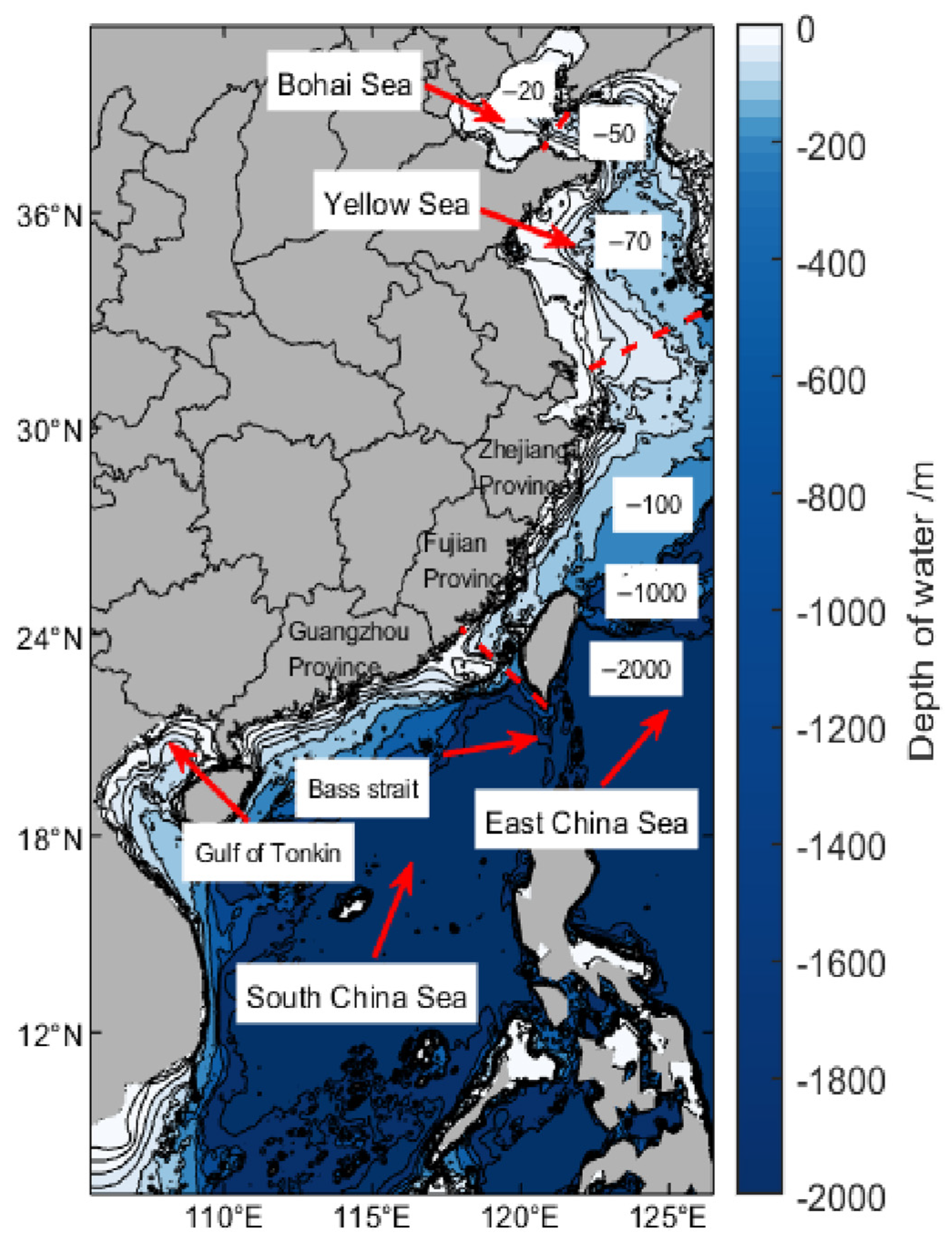
2.1. Study Area
2.2. Data Sources
3. Methods
Wave Energy Estimation
4. Result
4.1. The Annual Wave Energy Distribution
4.2. The Seasonal Wave Energy Distribution
4.3. The Monthly Wave Energy Distribution
5. The Long-Term Tendency of Wave Energy
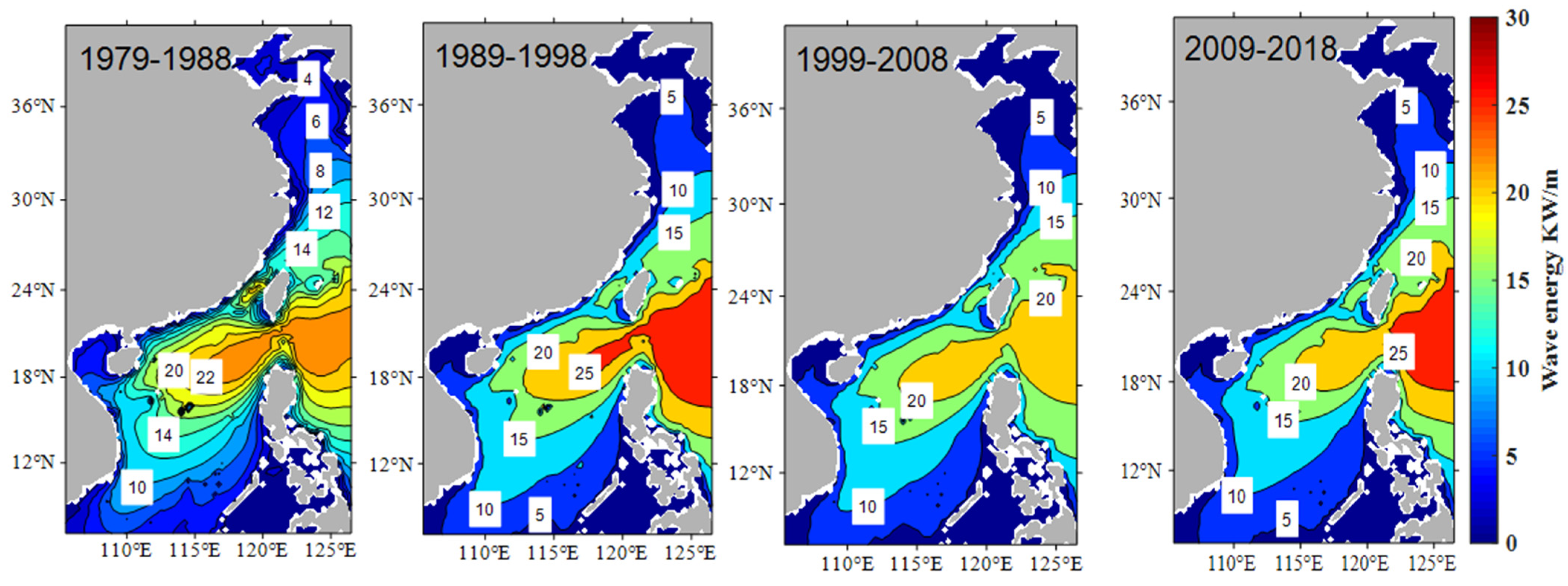
5.1. The Decade Distribution of Wave Energy Density
5.2. The Decade Distribution of Seasonal Wave Energy
6. The Extreme Wave Height
6.1. The Annual Mean Extreme Wave Height
6.2. The Seasonal Extreme Wave Heights
7. The Key Recommended Area of Wave Energy
7.1. The Area with Suitable Significant Wave Height and Water Depth
7.2. Key Recommended Areas of Wave Energy Utilization
8. Conclusions
Author Contributions
Funding
Institutional Review Board Statement
Informed Consent Statement
Data Availability Statement
Conflicts of Interest
References
- Li, N.; García-Medina, G.; Cheung, K.F.; Yang, Z. Wave energy resources assessment for the multi-modal sea state of Hawaii. Renew. Energy 2021, 174, 1036–1055. [Google Scholar] [CrossRef]
- Greenwood, C.; Christie, D.; Venugopal, V.; Morrison, J.; Vogler, A. Modelling performance of a small array of Wave Energy Converters: Comparison of Spectral and Boussinesq models. Energy 2016, 113, 258–266. [Google Scholar] [CrossRef]
- Audet, C.; Tribes, C. Mesh-based NeldereMead algorithm for inequality constrained optimization. Comput. Optim. Appl. 2018, 71, 331–352. [Google Scholar] [CrossRef]
- Kumar, V.S.; Naseef, T.M. Performance of ERA-Interim Wave Data in the Nearshore Waters around India. J. Atmos. Ocean. Tech. 2015, 32, 1257–1269. [Google Scholar] [CrossRef]
- Iglesias, G.; Carballo, R. Wave energy resource in the Estaca de Bares area (Spain). Renew. Energy 2010, 35, 1574–1584. [Google Scholar] [CrossRef]
- Iglesias, G.; Carballo, R. Offshore and inshore wave energy assessment: Asturias (Spain). Energy 2010, 35, 1964–1972. [Google Scholar] [CrossRef]
- Iglesias, G.; Carballo, R. Wave resource in El Hierro-an island towards energy self-sufficiency. Renew. Energy 2011, 36, 689–698. [Google Scholar] [CrossRef]
- Stopa, J.E.; Filipot, J.F.; Li, N.; Cheung, K.F.; Chen, Y.L.; Vega, L. Wave energy resources along the Hawaiian Island chain—ScienceDirect. Renew. Energy 2013, 55, 305–321. [Google Scholar] [CrossRef]
- Mollison, D. Wave climate and the wave power resource. In Hydrodynamics of Ocean Wave-Energy Utilization; Springer: Berlin/Heidelberg, Germany, 1986; pp. 133–156. [Google Scholar]
- Chiu, F.C.; Huang, W.Y.; Tiao, W.C. The spatial and temporal characteristics of the wave energy resources around Taiwan. Renew. Energy 2013, 52, 218–221. [Google Scholar] [CrossRef]
- Young, I.R. Seasonal variability of the global ocean wind and wave climate. Int. J. Climatol. 1999, 19, 931–950. [Google Scholar] [CrossRef]
- Hemer, M.A.; Church, J.A.; Hunter, J.R. Variability and trends in the directional wave climate of the Southern Hemisphere. Int. J. Climatol. 2010, 30, 475–491. [Google Scholar] [CrossRef]
- Woolf, D.K.; Challenor, P.G.; Cotton, P.D. The variability and predictability of North Atlantic wave climate. J. Geophys. Res.-Oceans 2002, 107, 3145. [Google Scholar] [CrossRef]
- Young, I.R.; Zieger, S.; Babanin, A.V. Global trends in wind speed and wave height. Science 2011, 332, 451–455. [Google Scholar] [CrossRef]
- Shi, H.Y.; Cao, X.F.; Li, Q.J.; Li, D.L.; Sun, J.; You, Z.; Sun, Q. Evaluating the Accuracy of ERA5 Wave Reanalysis in the Water around China. J. Ocean Univ. China 2021, 20, 1–9. [Google Scholar] [CrossRef]
- Le Traon, P.Y. From satellite altimetry to Argo and operational oceanography: Three revolutions in oceanography. Ocean Sci. 2013, 10, 1127–1167. [Google Scholar] [CrossRef]
- Arinaga, R.A.; Cheung, K.F. Atlas of global wave energy from 10 years of reanalysis and hindcast data. Renew. Energy 2012, 39, 49–64. [Google Scholar] [CrossRef]
- Folley, M.; Whittaker, T.J.T. Analysis of the nearshore wave energy resource. Renew. Energy 2009, 34, 1709–1715. [Google Scholar] [CrossRef]
- Rusu, E.; Onea, F. Evaluation of the wind and wave energy along the Caspian Sea. Energy 2013, 50, 1–14. [Google Scholar] [CrossRef]
- Neill, S.P.; Hashemi, M.R. Wave power variability over the northwest European shelf seas. Appl. Energy 2013, 106, 31–46. [Google Scholar] [CrossRef]
- Pontes, M.T.; Barstow, S.; Bertotti, L.L.; Cavaleri, H. Use of numerical wind-wave models for assessment of the offshore wave energy resource. J. Offshore Mech. Arct. Eng. 1997, 119, 184–190. [Google Scholar] [CrossRef]
- Pontes, M.T. Assessing the European wave energy resource. J. Offshore Mech. Arct. Eng. 1998, 120, 226–231. [Google Scholar] [CrossRef]
- Rusu, E.; Soares, C.G. Wave energy pattern around the Madeira Islands. Energy 2012, 45, 771–785. [Google Scholar] [CrossRef]
- Reguero, B.G.; Losada, I.J.; Mendez, F.J. A global wave power resource and its seasonal, interannual and long-term variability. Appl. Energy 2015, 148, 366–380. [Google Scholar] [CrossRef]
- Bechtle, P.; Schelbergen, M.; Schmehl, R.; Zillmann, U.; Watson, S. Airborne wind energy resource analysis. Renew. Energy 2019, 141, 1103–1116. [Google Scholar] [CrossRef]
- Mahmoodi, K.; Ghassemi, H.; Razminia, A. Temporal and spatial characteristics of wave energy in the Persian Gulf based on the ERA5 reanalysis dataset. Energy 2019, 187, 115991. [Google Scholar] [CrossRef]
- Wan, Y.; Zhang, J.; Meng, J.; Wang, J. Exploitable wave energy assessment based on ERA-Interim reanalysis data—A case study in the East China Sea and the South China Sea. Acta Oceanol. Sin. 2015, 34, 143–155. [Google Scholar] [CrossRef]
- Wan, Y.; Zhang, J.; Meng, J.; Wang, J. A wave energy resource assessment in the China’s seas based on multi-satellite merged radar altimeter data. Acta Oceanol. Sin. 2015, 34, 115–124. [Google Scholar] [CrossRef]
- Zheng, C.W.; Pan, J.; Li, J.X. Assessing the China Sea wind energy and wave energy resources from 1988 to 2009. Ocean Eng. 2013, 65, 39–48. [Google Scholar] [CrossRef]
- Liang, B.C.; Fan, F.; Yin, Z.; Shi, H.; Lee, D. Numerical modelling of the nearshore wave energy resources of Shandong peninsula China. Renew. Energy 2013, 57, 330–338. [Google Scholar] [CrossRef]
- Beji, S. Improved explicit approximation of linear dispersion relationship for gravity waves. Coast. Eng. 2013, 73, 11–12. [Google Scholar] [CrossRef]
- You, Z.J. A close approximation of wave dispersion relation for direct calculation of wavelength in any coastal water depth. Appl. Ocean Res. 2008, 30, 113–119. [Google Scholar] [CrossRef]
- Dee, D.P.; Uppala, S.M.; Simmons, A.J.; Berrisford, P.; Poli, P.; Kobayashi, S.; Andrae, U.; Balmaseda, M.A.; Balsamo, G.; Bauer, D.P.; et al. The ERA-Interim reanalysis: Configuration and performance of the data assimilation system. Q. J. R. Meteorol. Soc. 2011, 137, 553–597. [Google Scholar] [CrossRef]
- Hersbach, H.; Dee, D. ERA5 reanalysis is in production. ECMWF Newsl. 2016, 147, 5–6. [Google Scholar]
- Czernecki, B.; Taszarek, M.; Marosz, M.; Półrolniczak, M.; Kolendowicz, L.; Wyszogrodzki, A.; Szturc, J. Application of machine learning to large hail prediction—The importance of radar reflectivity, lightning occurrence and convective parameters derived from ERA5. Atmos. Res. 2019, 227, 249–262. [Google Scholar] [CrossRef]
- Rohrer, M.; Martius, O.; Raible, C.C.; Brönnimann, S. Sensitivity of Blocks and Cyclones in ERA5 to Spatial Resolution and Definition. Geophys. Res. Lett. 2020, 47, e2019GL085582. [Google Scholar] [CrossRef]
- Lavers, D.A.; Simmons, A.; Vamborg, F.; Rodwell, M.J. Anevaluation of ERA5 precipitation forclimate monitoring. Q. J. R. Meteorol. Soc. 2022, 148, 3152–3165. [Google Scholar] [CrossRef]
- Liang, B.; Shao, Z.; Wu, G.; Shao, M.; Sun, J. New equations of wave energy assessment accounting for the water depth. Appl. Energy 2017, 188, 130–139. [Google Scholar] [CrossRef]
- Wan, Y.; Fan, C.; Dai, Y.; Li, L.; Sun, W.; Zhou, P.; Qu, X. Assessment of the joint development potential of wave and wind energy in the South China Sea. Energies 2018, 11, 398. [Google Scholar] [CrossRef]
- Wan, Y.; Zheng, C.; Li, L.; Dai, Y.; Esteban, M.D.; López-Gutiérrez, J.S.; Qu, X.; Zhang, X. Wave energy assessment related to wave energy convertors in the coastal waters of China. Energy 2020, 202, 117741. [Google Scholar] [CrossRef]


Publisher’s Note: MDPI stays neutral with regard to jurisdictional claims in published maps and institutional affiliations. |
© 2022 by the authors. Licensee MDPI, Basel, Switzerland. This article is an open access article distributed under the terms and conditions of the Creative Commons Attribution (CC BY) license (https://creativecommons.org/licenses/by/4.0/).
Share and Cite
Shi, H.; Zhang, X.; Du, W.; Li, Q.; Qu, H.; You, Z. Assessment of Wave Energy Resources in China. J. Mar. Sci. Eng. 2022, 10, 1771. https://doi.org/10.3390/jmse10111771
Shi H, Zhang X, Du W, Li Q, Qu H, You Z. Assessment of Wave Energy Resources in China. Journal of Marine Science and Engineering. 2022; 10(11):1771. https://doi.org/10.3390/jmse10111771
Chicago/Turabian StyleShi, Hongyuan, Xuri Zhang, Wenyan Du, Qingjie Li, Hengliang Qu, and Zaijin You. 2022. "Assessment of Wave Energy Resources in China" Journal of Marine Science and Engineering 10, no. 11: 1771. https://doi.org/10.3390/jmse10111771
APA StyleShi, H., Zhang, X., Du, W., Li, Q., Qu, H., & You, Z. (2022). Assessment of Wave Energy Resources in China. Journal of Marine Science and Engineering, 10(11), 1771. https://doi.org/10.3390/jmse10111771