
Modeling and Assessing Potential Soil Erosion Hazards Using USLE and Wind Erosion Models in Integration with GIS Techniques: Dakhla Oasis, Egypt

 ,
, 
 , and
, and 
Abstract
:1. Introduction
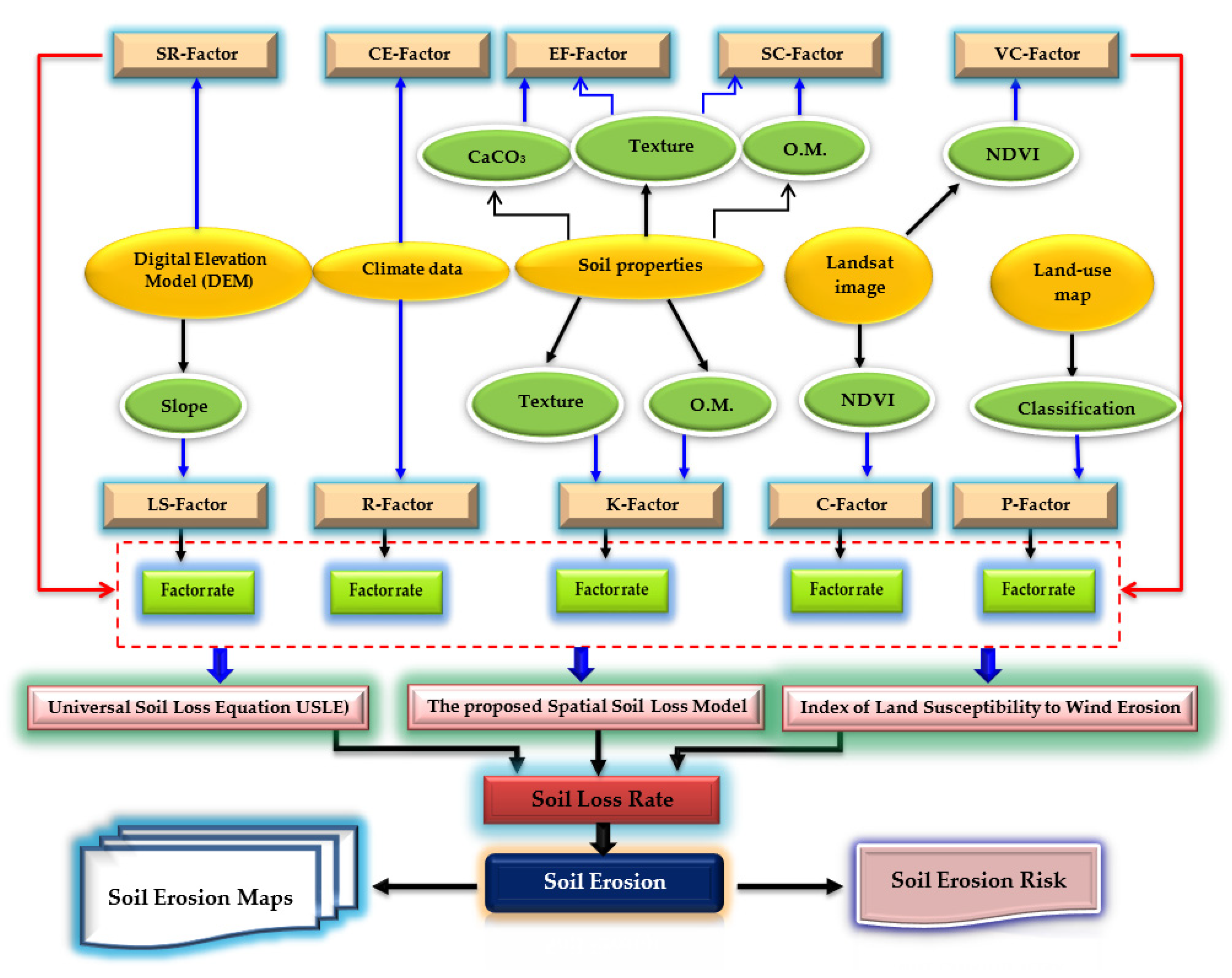
2. Materials and Methods
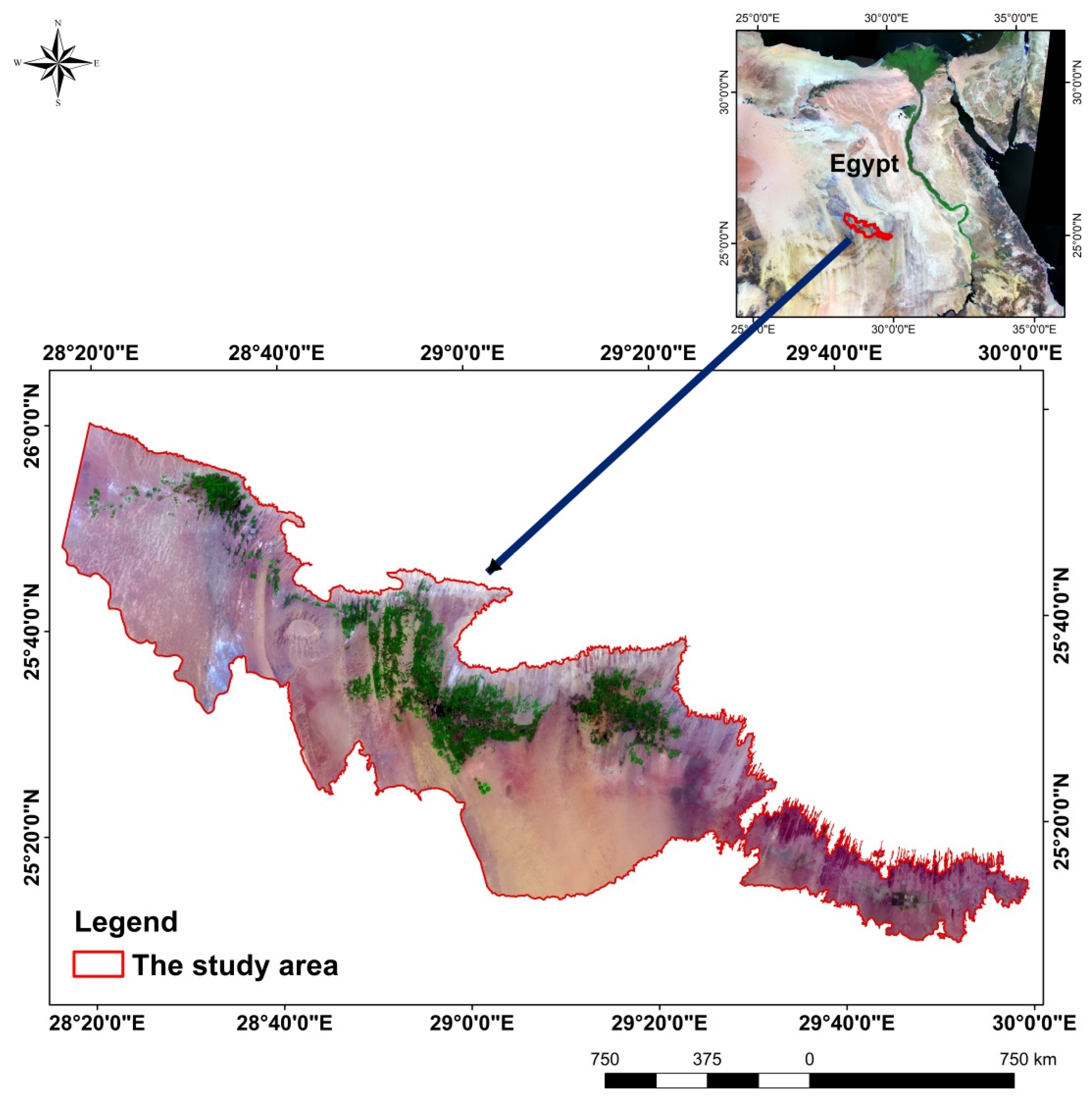
2.1. Study Area Description
2.2. Digital Images Processing
2.3. Field Survey and Laboratory Analyses
2.4. The Universal Soil Loss Equation (USLE) Model
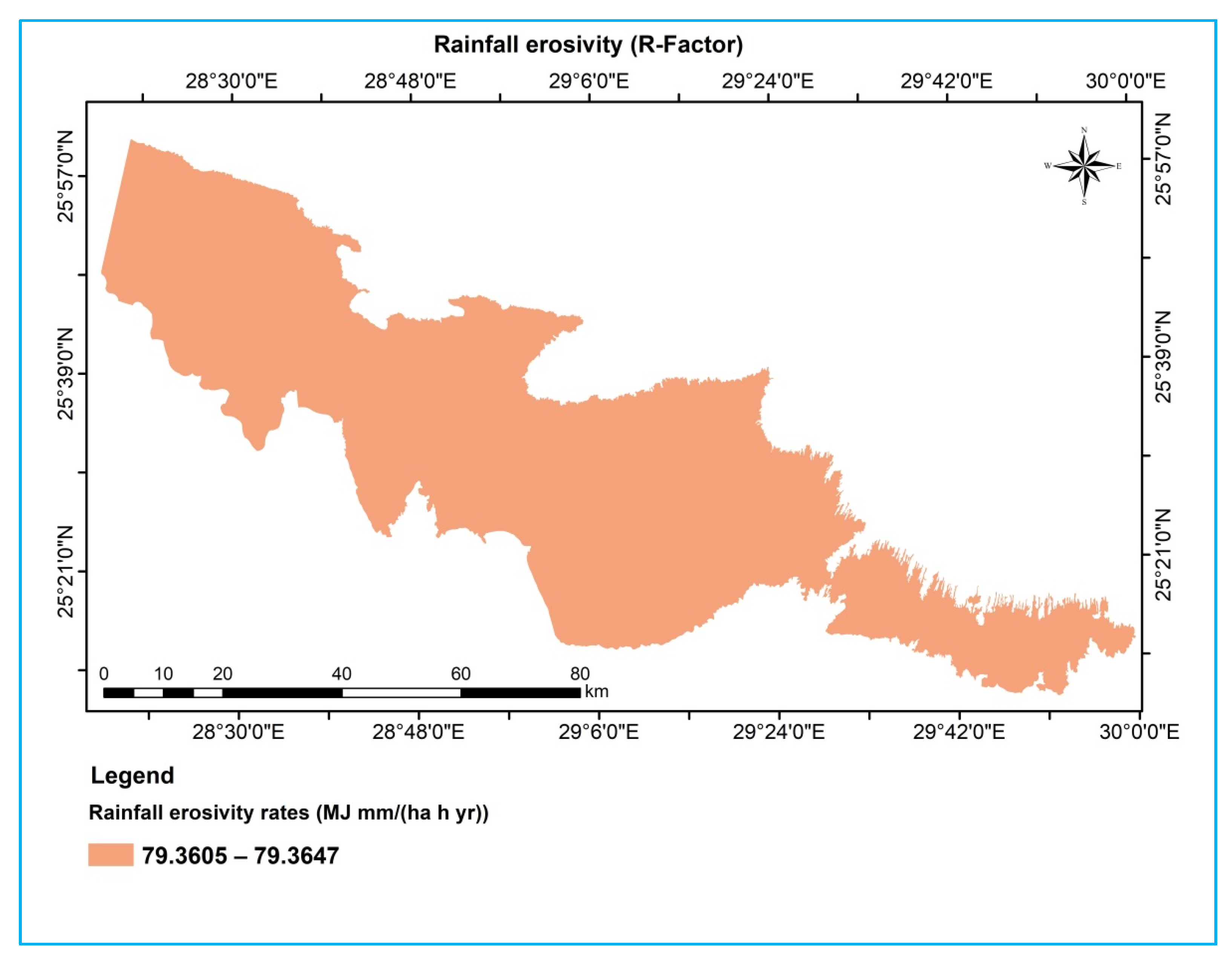
2.4.1. Rainfall Erosivity (R-Factor)
2.4.2. Soil Erodibility (K-Factor)
2.4.3. Slope Length and Slope Gradient (LS-Factor)
2.4.4. Cropping Management (C-Factor)
2.4.5. Conservation Practice (P-Factor)
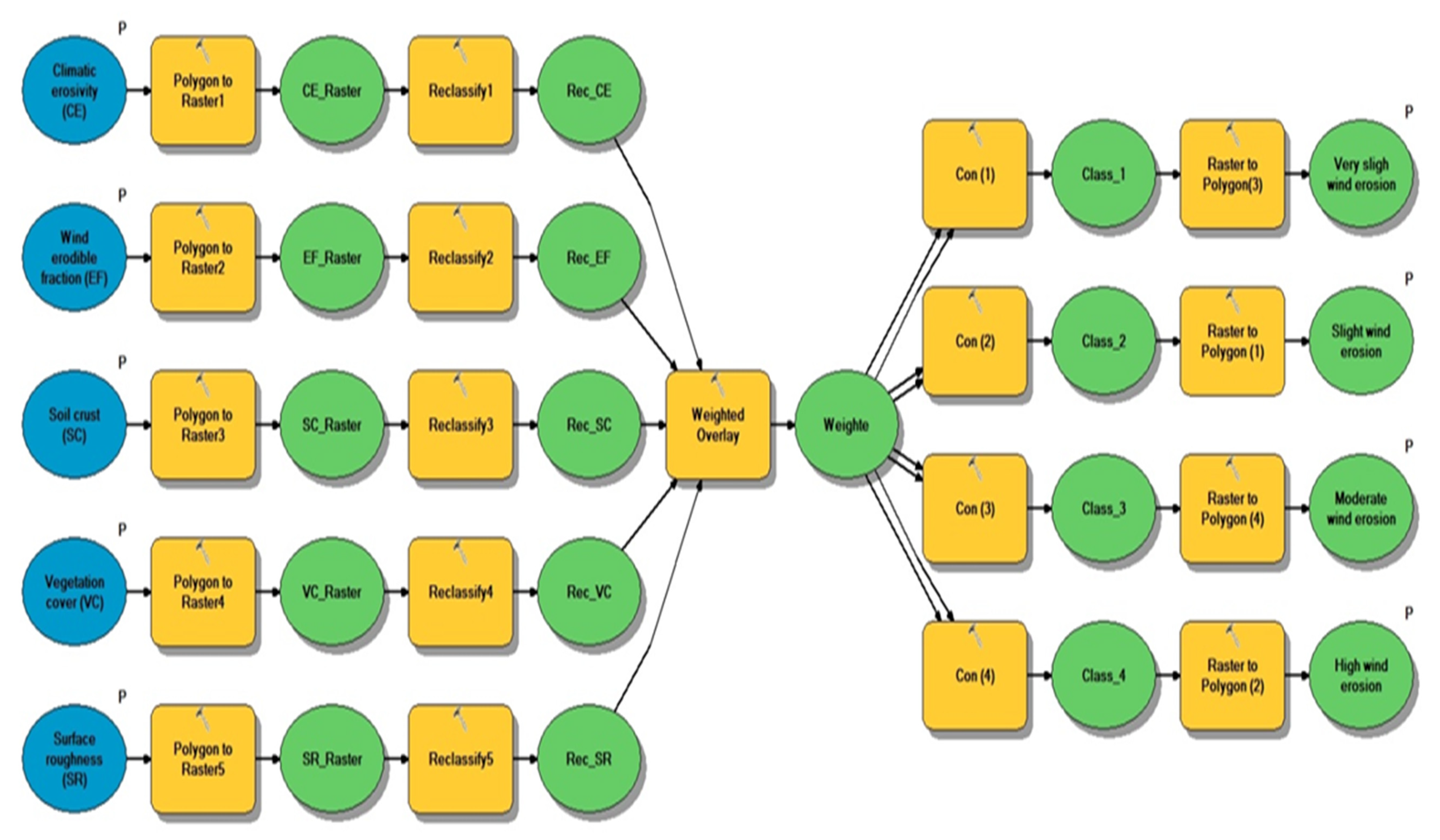
2.5. Index of Land Susceptibility to Wind Erosion (ILSWE) Model
2.5.1. Climatic Erosivity (CE-Factor)
2.5.2. Wind-Erodible Fraction (EF-Factor)
2.5.3. Soil Crust (SC-Factor)
2.5.4. Vegetation Cover Factor (VC-Factor)
2.5.5. Surface Roughness Factor (SR-Factor)
2.6. Spatial Soil Loss Model (SSlM) Designing
2.7. Model Validation
3. Results and Discussion
3.1. Study Area Characteristics
3.2. Determination and Spatial Distribution of the USLE Model Factors
3.2.1. Rainfall Erosivity Factor (R-Factor)
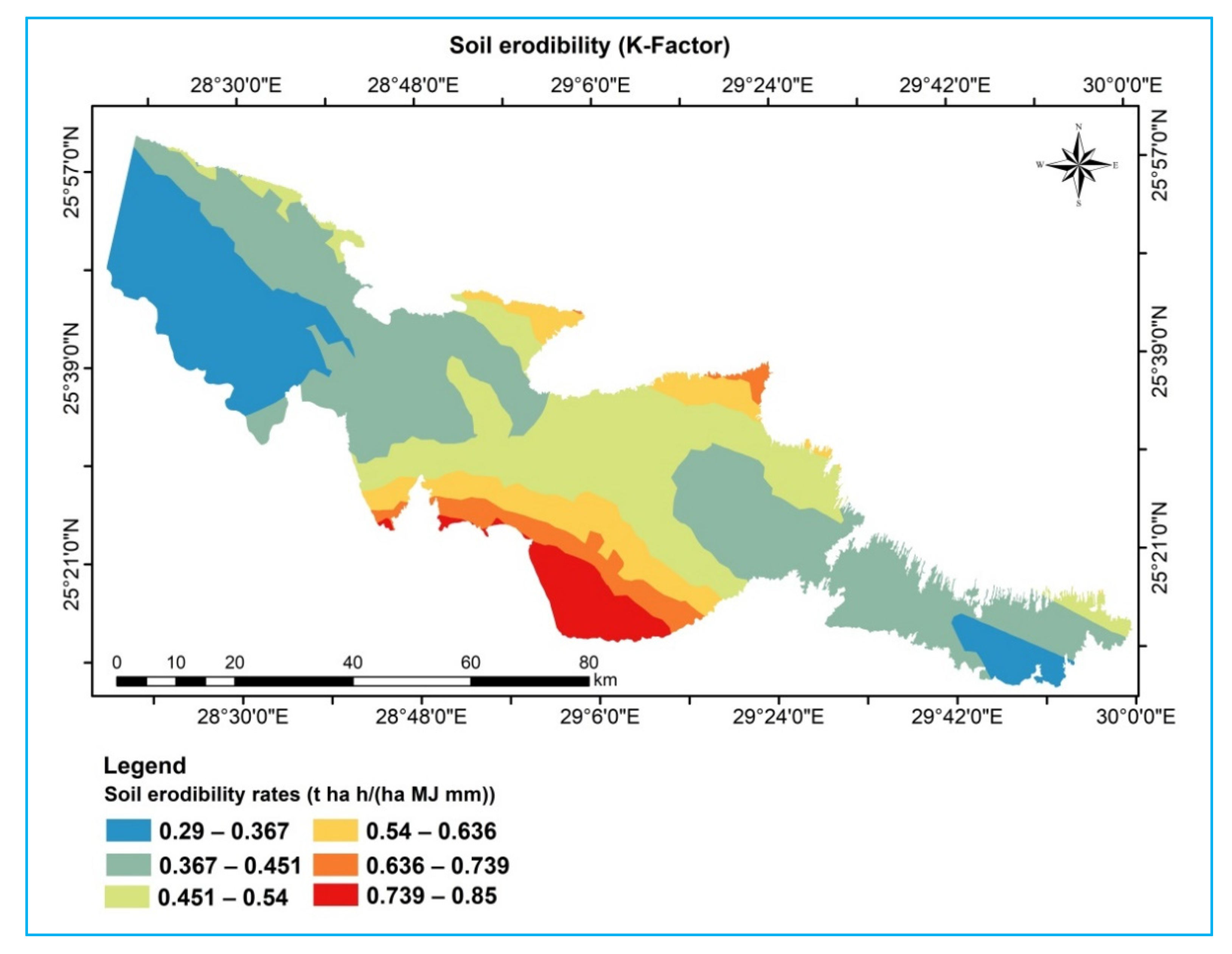
3.2.2. Soil Erodibility Factor (K-Factor)
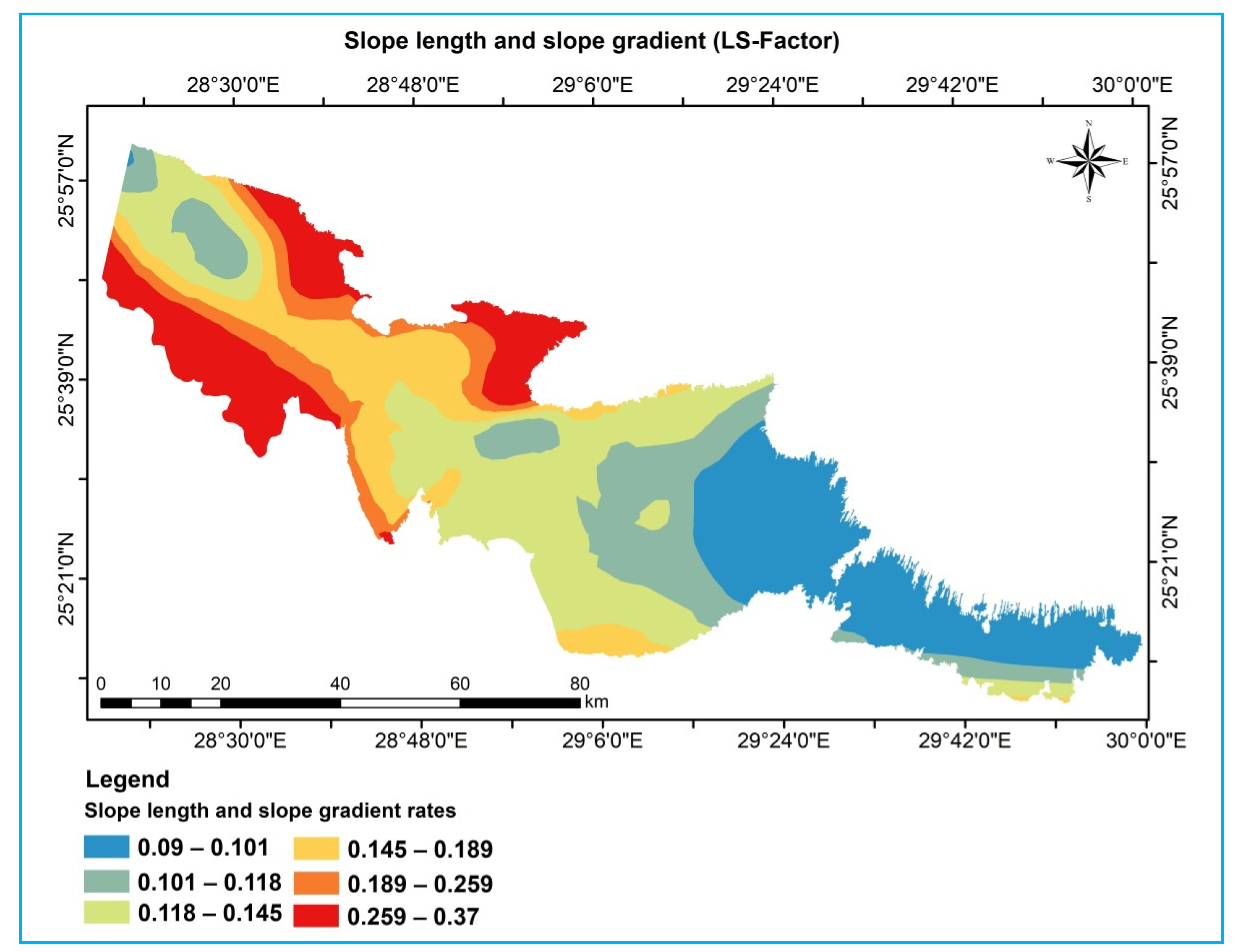
3.2.3. Slope Length and Slope Gradient Factor (LS-Factor)
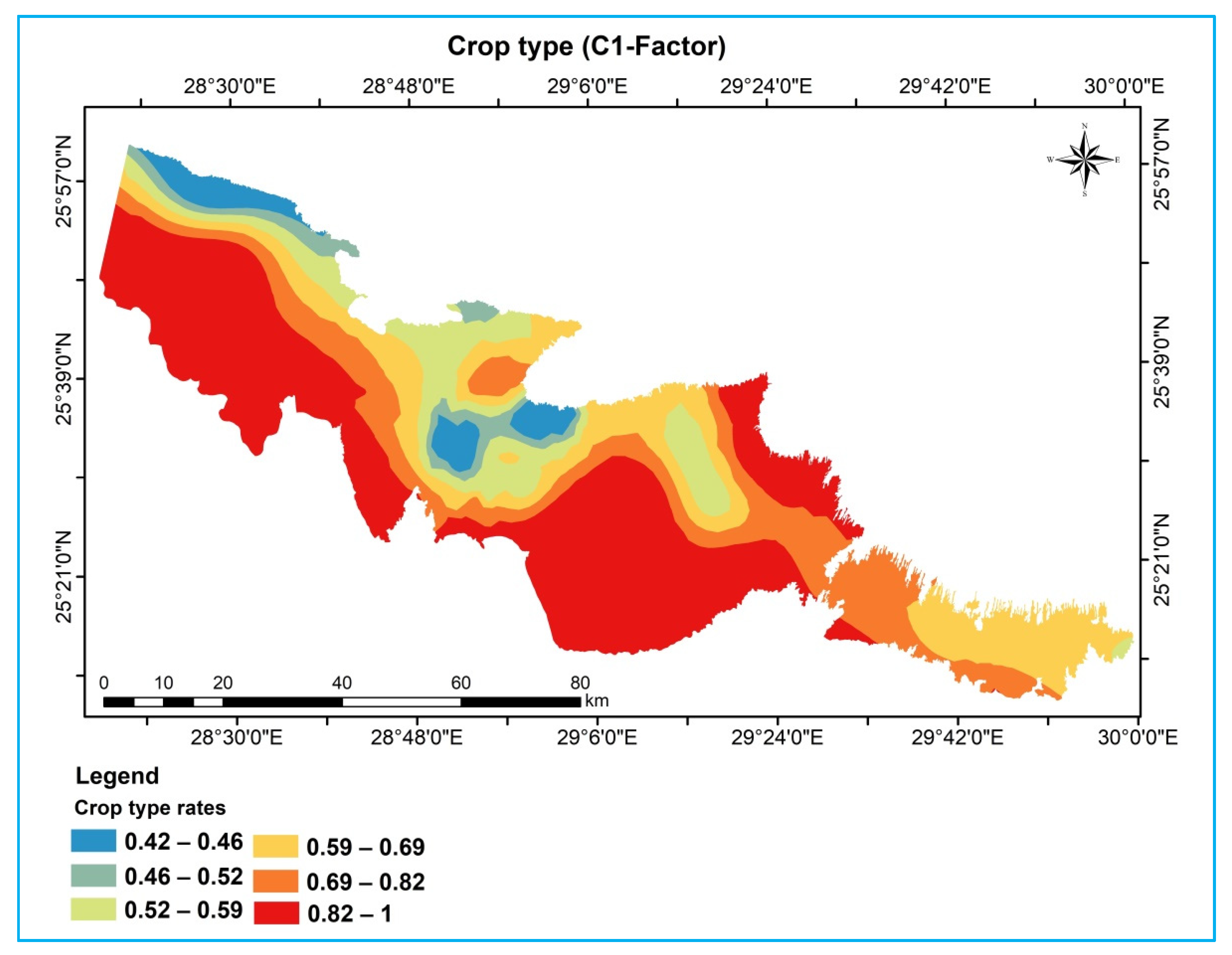
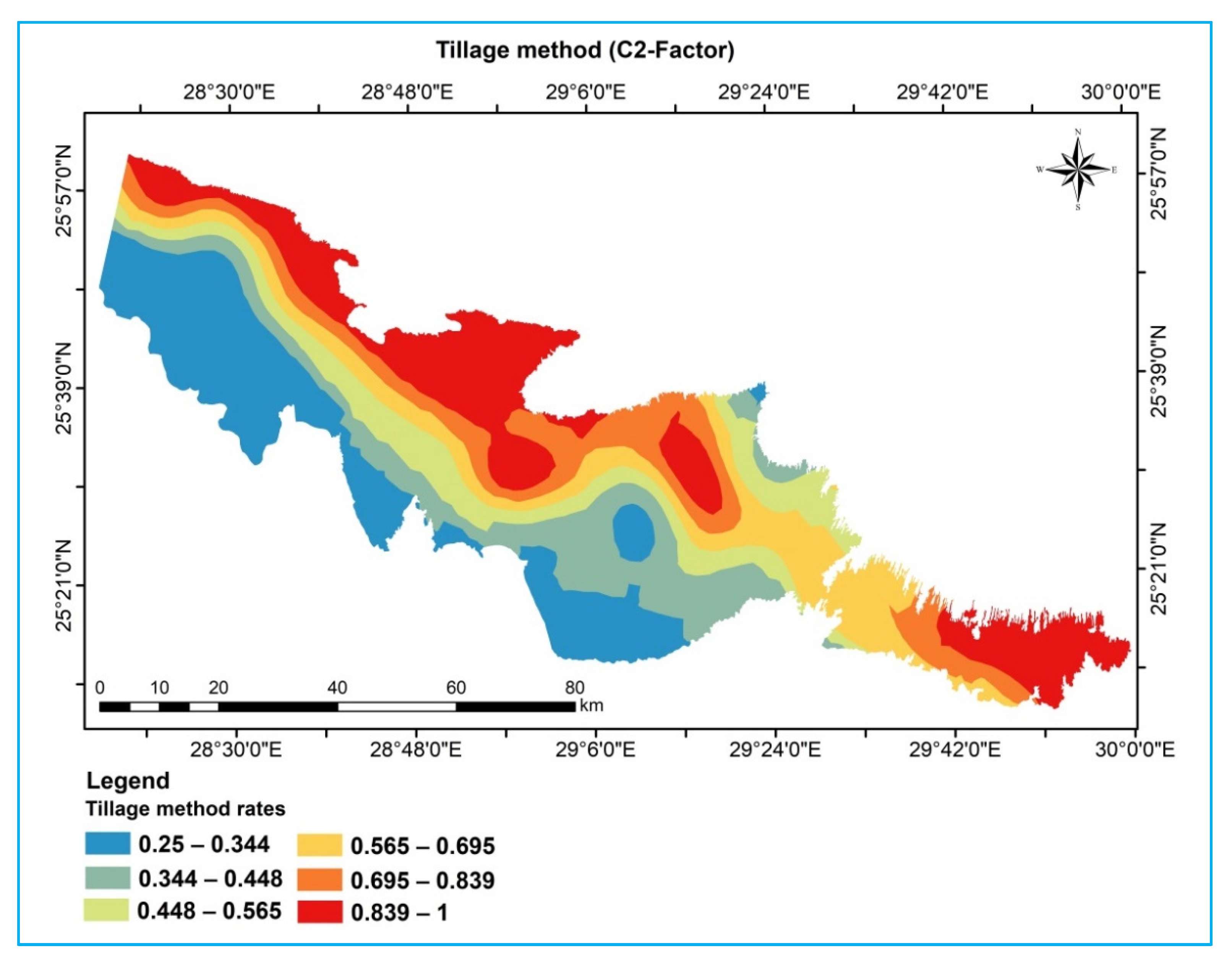
3.2.4. Cover Management Factor (C-Factor)
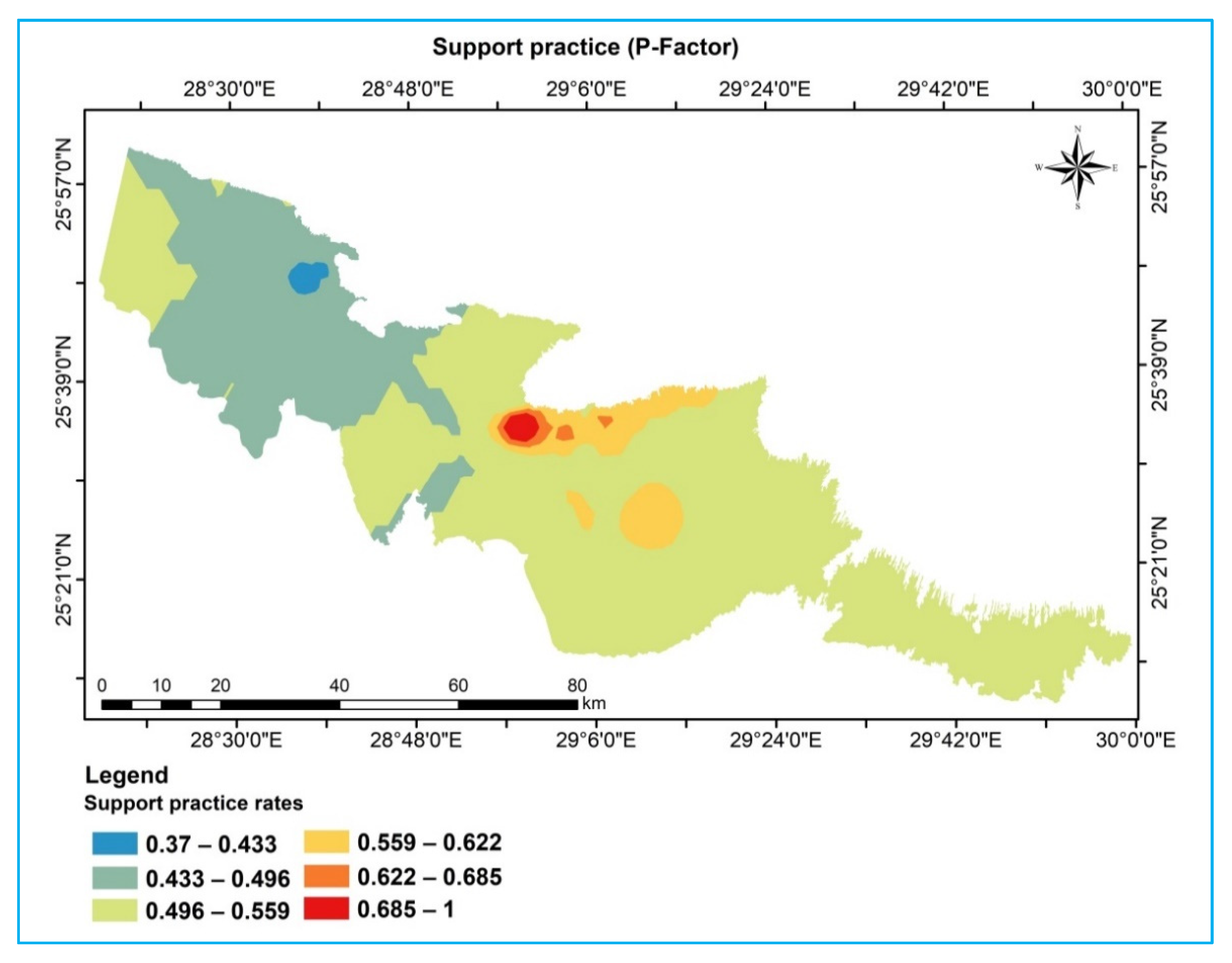
3.2.5. Conservation Practice (P-Factor)
3.3. Soil Erosion Assessment
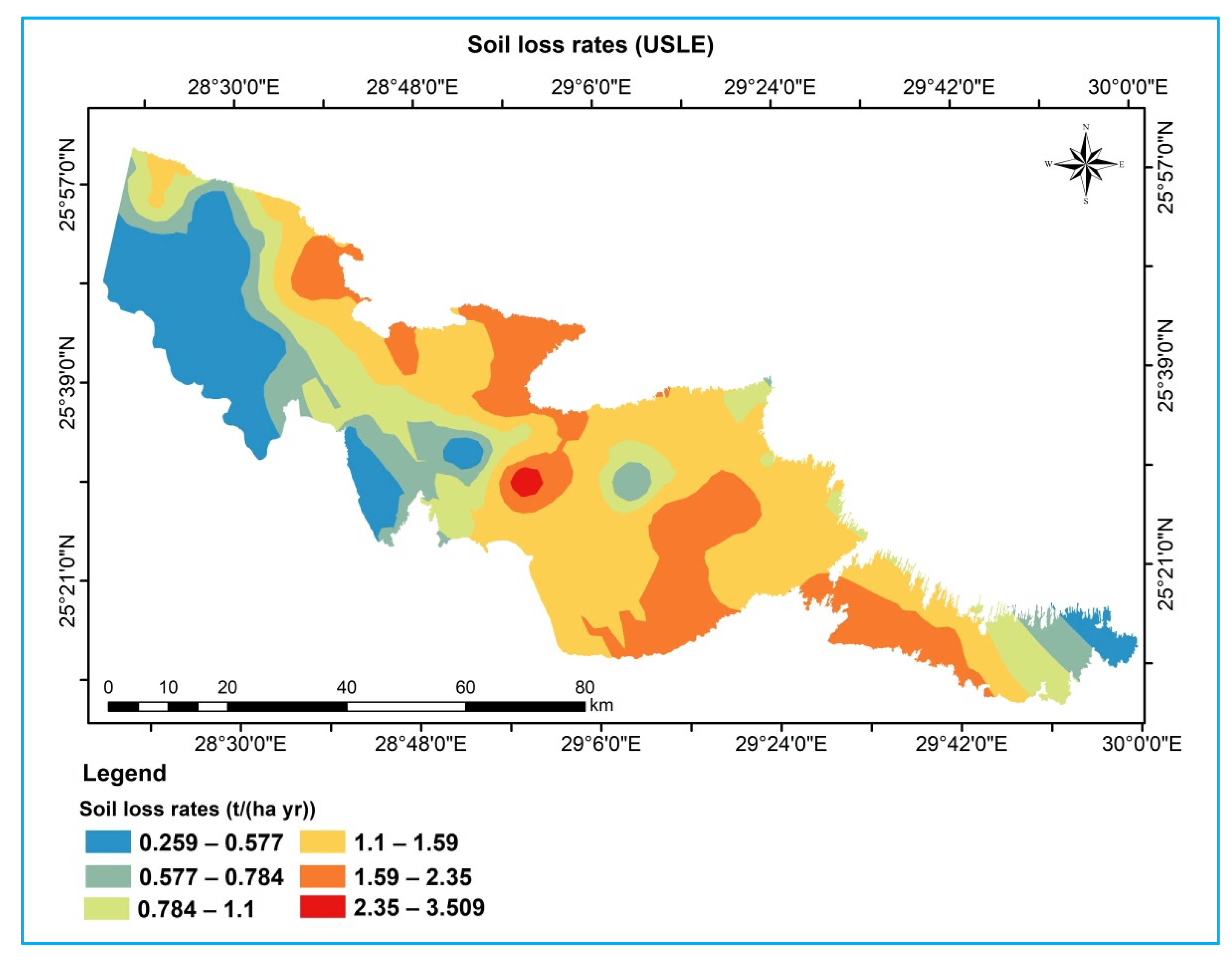
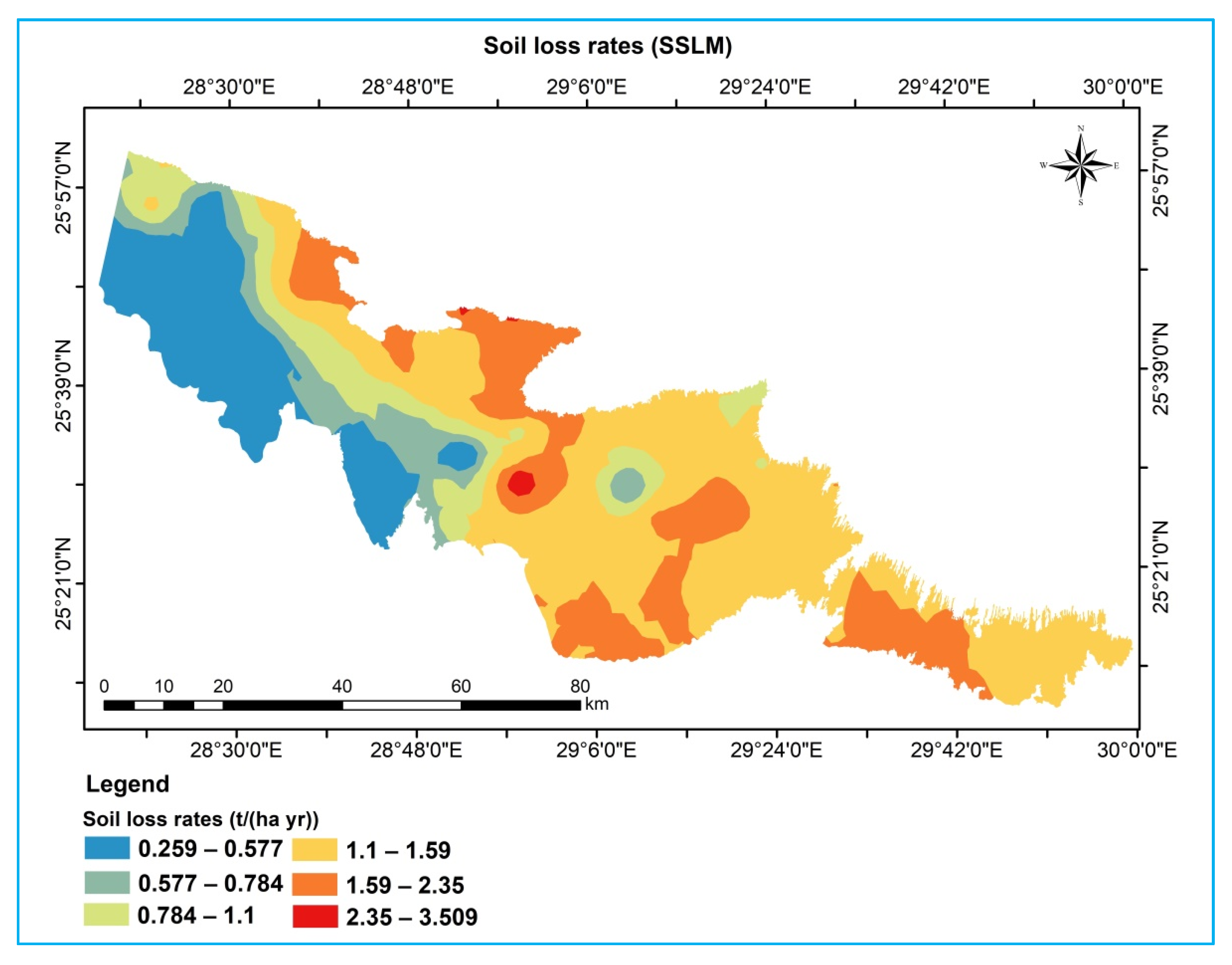
3.3.1. Water Erosion
- 1.
- Based on the USLE model
- 2.
- Based on the SSLM
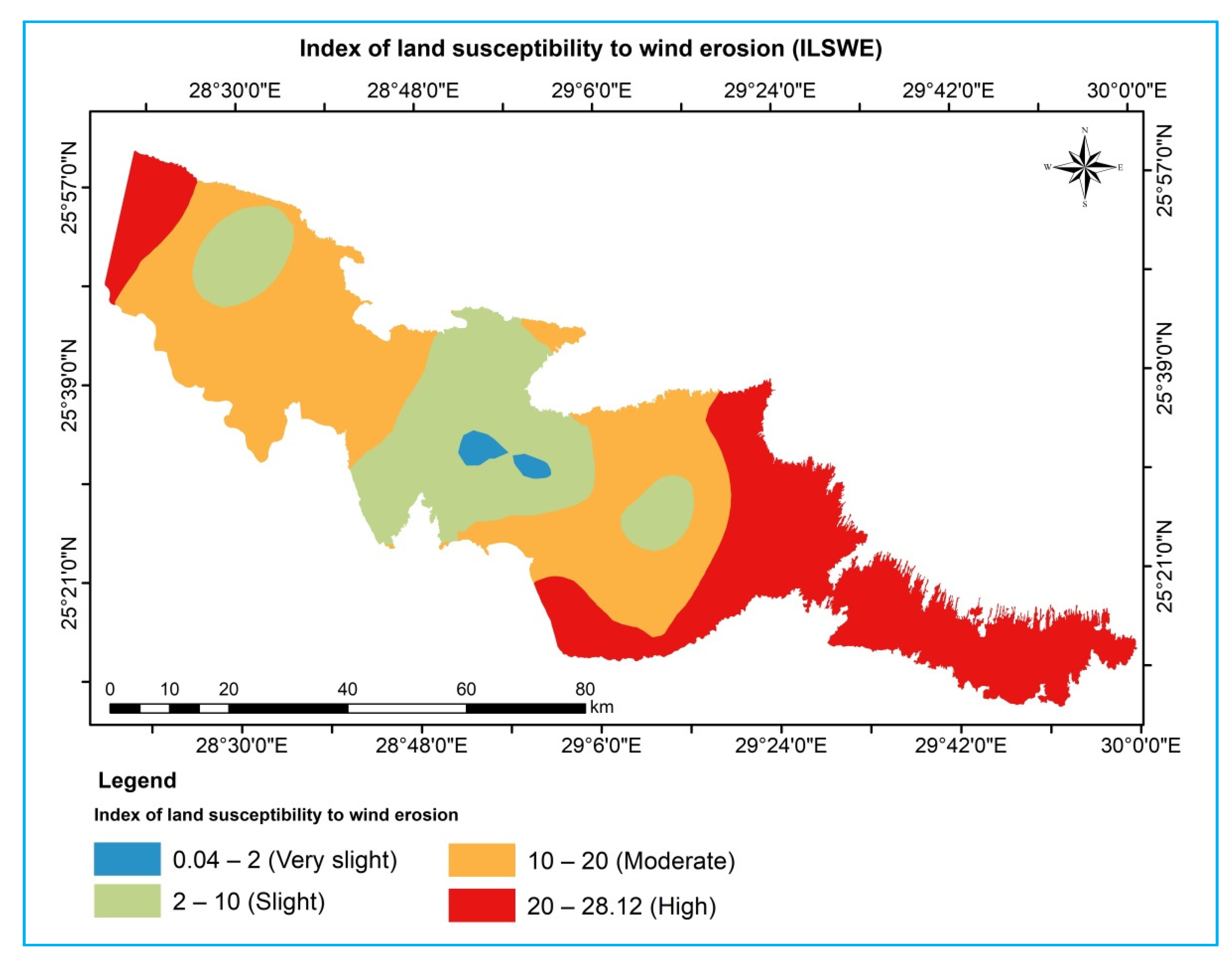
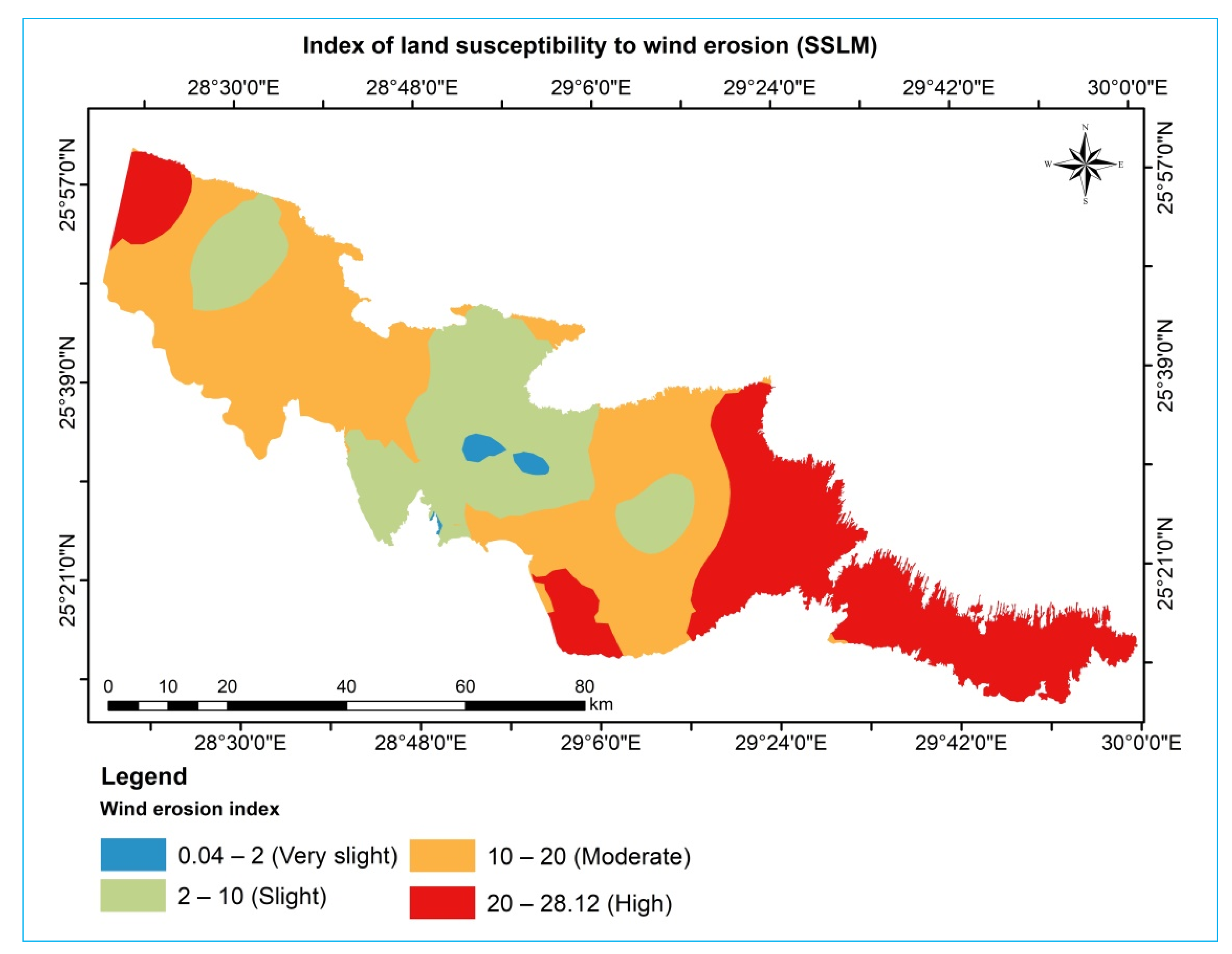
3.3.2. Wind Erosion
- 1.
- Based on the ILSWE model
- 2.
- Based on the SSLM
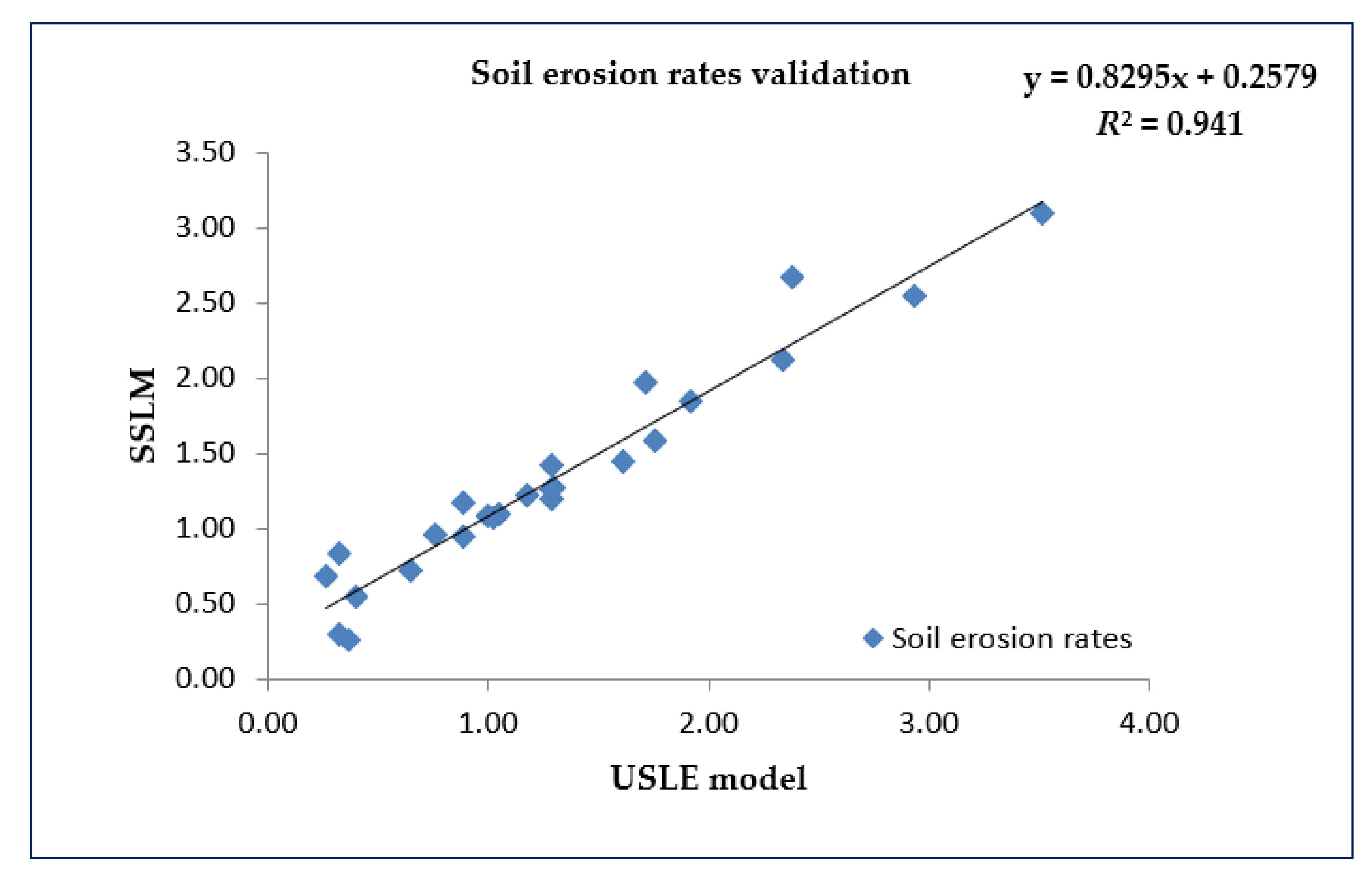
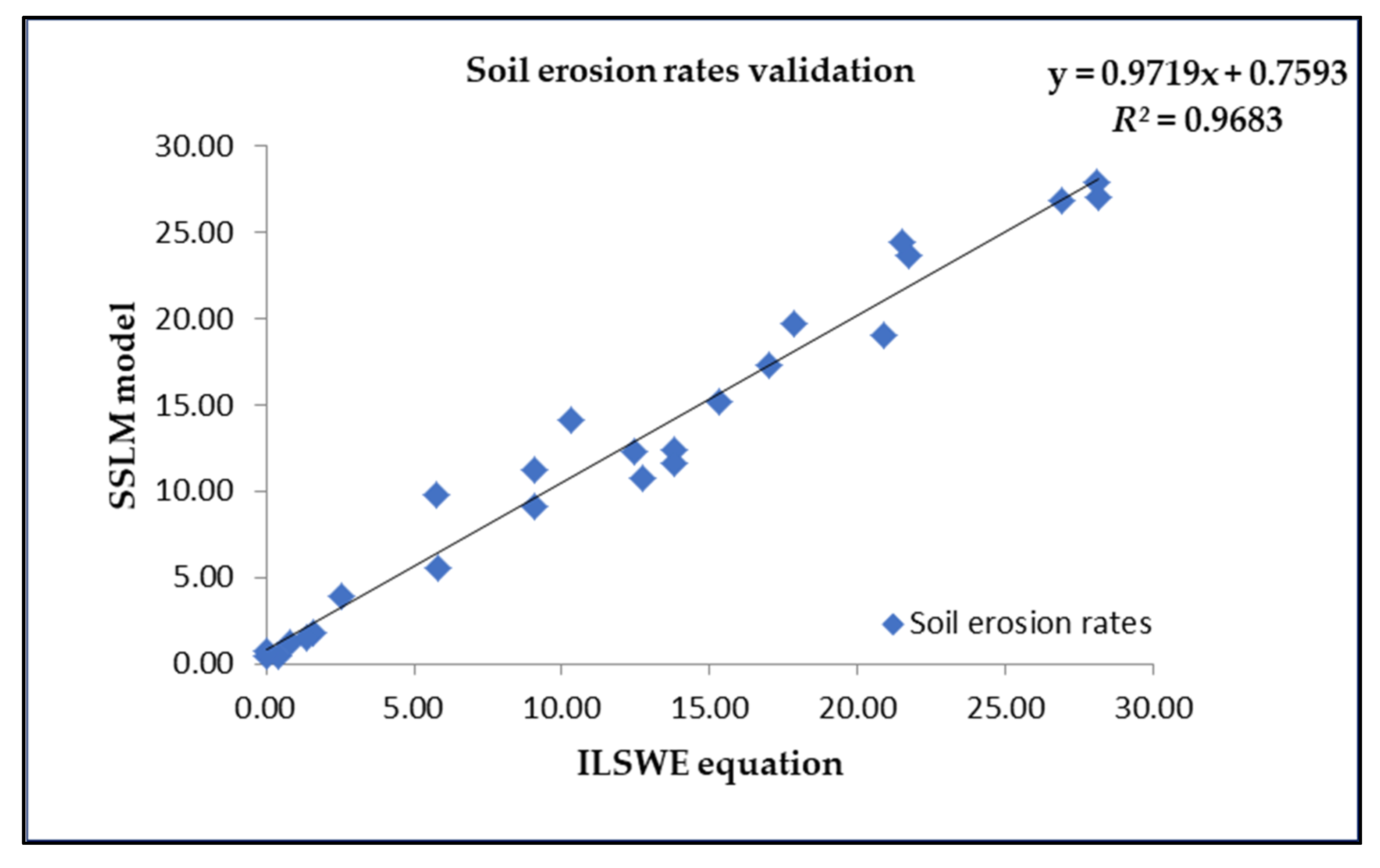
3.4. Model Validation
4. Conclusions
Author Contributions
Funding
Institutional Review Board Statement
Informed Consent Statement
Data Availability Statement
Acknowledgments
Conflicts of Interest
References
- Rahman, M.R.; Shi, Z.H.; Chongfa, C. Soil erosion hazard evaluation—An integrated use of remote sensing, GIS and statistical approaches with biophysical parameters towards management strategies. Ecol. Modell. 2009, 220, 1724–1734. [Google Scholar] [CrossRef]
- Panagos, P.; Borrelli, P.; Meusburger, K.; Yu, B.; Klik, A.; Lim, K.J.; Yang, J.E.; Ni, J.; Miao, C.; Chattopadhyay, N.; et al. Global rainfall erosivity assessment based on high-temporal resolution rainfall records. Sci. Rep. 2017, 7, 1–12. [Google Scholar] [CrossRef] [PubMed] [Green Version]
- Lal, R. Soil degradation by erosion. Land Degrad. Dev. 2001, 12, 519–539. [Google Scholar] [CrossRef]
- Lal, R. Soil erosion and the global carbon budget. Environ. Int. 2003, 29, 437–450. [Google Scholar] [CrossRef]
- FAO; ITPS. Status of the World’s Soil Resources (SWSR)—Main Report, 1st ed.; Luco, M., Victor, C., Kazuyuki, Y., Pavel, K., Seyed, K.A.P., de Lourdes, M.M., Dan, P., Neil, M., Eds.; Food and Agriculture Organization of the United Nations and Intergovernmental Technical Panel on Soils: Rome, Italy, 2015; p. 607. [Google Scholar]
- Cerdà, A.; Flanagan, D.C.; Le Bissonnais, Y.; Boardman, J. Soil erosion and agriculture. Soil Tillage Res. 2009, 106, 107–108. [Google Scholar] [CrossRef]
- Edwards, W.M.; Owens, L.B. Large storm effects on total soil erosion. J. Soil Water Conserv. 1991, 46, 75–78. [Google Scholar]
- Ananda, J.; Herath, G. Soil erosion in developing countries: A socio-economic appraisal. J. Environ. Manag. 2003, 68, 343–353. [Google Scholar] [CrossRef]
- Merritt, W.S.; Letcher, R.A.; Jakeman, A.J. A review of erosion and sediment transport models. Environ. Model Softw. 2003, 18, 761–799. [Google Scholar] [CrossRef]
- Rizeei, H.M.; Saharkhiz, M.A.; Pradhan, B.; Ahmad, N. Soil erosion prediction based on land cover dynamics at the Semenyih watershed in Malaysia using LTM and USLE models. Geocarto Int. 2016, 31, 1158–1177. [Google Scholar] [CrossRef]
- Karydas, C.G.; Panagos, P.; Gitas, I.Z. A classification of water erosion models according to their geospatial characteristics. Int. J. Digit. Earth 2014, 7, 229–250. [Google Scholar] [CrossRef]
- Labrière, N.; Locatelli, B.; Laumonier, Y.; Freycon, V.; Bernoux, M. Soil erosion in the humid tropics: A systematic quantitative review. Agric. Ecosyst. Environ. 2015, 203, 127–139. [Google Scholar] [CrossRef]
- Wischmeier, W.H.; Smith, D.D. Predicting Rainfall Erosion Losses—A Guide to Conservation Planning; Agriculture Handbook No. 537; USDA-Science and Education Administration: Hyattsville, MD, USA, 1978; p. 67. [Google Scholar]
- Dabral, P.P.; Baithuri, N.; Pandey, A. Soil erosion assessment in a hilly catchment of north eastern India using USLE, GIS and remote sensing. Water Resour. Manag. 2008, 22, 1783–1798. [Google Scholar] [CrossRef]
- Karamage, F.; Zhang, C.; Kayiranga, A.; Shao, H.; Fang, X.; Ndayisaba, F.; Nahayo, L.; Mupenzi, C.; Tian, G. USLE-based assessment of soilerosion by water in the Nyabarongo River catchment, Rwanda. Int. J. Environ. Res. Public Health 2016, 13, 835. [Google Scholar] [CrossRef] [PubMed] [Green Version]
- Pham, T.G.; Degener, J.; Kappas, M. Integrated universalsoil loss equation (USLE) and Geographical Information System (GIS) for soil erosion estimation in a sap basin: Central Vietnam. Int. Soil Water Conserv. Res. 2018, 6, 99–110. [Google Scholar] [CrossRef]
- Melalih, A.; Mazour, M. Using RUSLE and GIS for the soil loss assessment in arid regions: The case of the Ain Sefra catchment in the Ksour Mountains, Algeria. J. Water Land Dev. 2021, 48, 205–214. [Google Scholar] [CrossRef]
- Jemai, S.; Kallel, A.; Agoubi, B.; Abid, H. Soil erosion estimation in arid area by USLE model applying GIS and RS: Case of Oued El Hamma catchment, south-eastern Tunisia. J. Indian Soc. Remote. Sens. 2021, 29, 1293–1305. [Google Scholar] [CrossRef]
- Othman, A.A.; Obaid, A.K.; Al-Manmi, D.A.M.A.; Al-Maamar, A.F.; Hasan, S.E.; Liesenberg, V.; Shihab, A.T.; Al-Saady, Y.I. New insight on soil loss estimation in the northwestern region of the Zagros fold and thrust belt. ISPRS Int. J. Geo-Inf. 2021, 10, 59. [Google Scholar] [CrossRef]
- Renard, K.G.; Foster, G.R.; Weesies, G.A.; McCool, D.K.; Yoder, D.C. Predicting Soil Erosion by Water: A Guide to Conservation Planning with the Revised Universal Soil Loss Equation (RUSLE); United States Department of Agriculture: Washington, DC, USA, 1997; p. 384. [Google Scholar]
- Gessesse, B.; Bewket, W.; Bräuning, A. Model-based characterization and monitoring of runoff and soil erosion in response to land use/land cover changes in the Modjo watershed, Ethiopia. Land Degrad. Dev. 2015, 26, 711–724. [Google Scholar] [CrossRef]
- Sepuru, T.K.; Dube, T. An appraisal on the progress of remote sensing applications in soil erosion mapping and monitoring. Remote Sens. Appl. Soc. Environ. 2018, 9, 1–9. [Google Scholar] [CrossRef]
- Vrieling, A.; Sterk, G.; de Jong, S.M. Satellite-based estimation of rainfall erosivity for Africa. J. Hydrol. 2010, 395, 235–241. [Google Scholar] [CrossRef]
- Rahman, M.R.; Shi, Z.H.; Chongfa, C.; Dun, Z. Assessing soil erosion hazard -a raster based GIS approach with spatial principal component analysis (SPCA). Earth Sci. Inform. 2015, 8, 853–865. [Google Scholar] [CrossRef]
- Pradhan, B.; Chaudhari, A.; Adinarayana, J.; Buchroithner, M.F. Soil erosion assessment and its correlation with landslide events using remote sensing data and GIS: A case study at Penang Island, Malaysia. Environ. Monit. Assess. 2012, 184, 715–727. [Google Scholar] [CrossRef] [PubMed]
- Zeng, Z.Y.; Cao, J.Z.; Gu, Z.J.; Zhang, Z.L.; Zheng, W.; Cao, Y.Q.; Peng, H.Y. Dynamic monitoring of plant cover and soil erosion using remote sensing, mathematical modeling, computer simulation and GIS techniques. Am. J. Plant Sci. 2013, 4, 1466–1493. [Google Scholar] [CrossRef]
- Seutloali, K.E.; Dube, T.; Mutanga, O. Assessing and mapping the severity of soil erosion using the 30-m Landsat multispectral satellite data in the former South African homelands of Transkei. Phys. Chem. Earth 2017, 100, 296–304. [Google Scholar] [CrossRef]
- Tralli, D.M.; Blom, R.G.; Zlotnicki, V.; Donnellan, A.; Evans, D.L. Satellite remote sensing of earthquake, volcano, flood, landslide and coastal inundation hazards. ISPRS J. Photogramm. Remote Sens. 2005, 59, 185–198. [Google Scholar] [CrossRef]
- Brits, A.; Burke, M.; Li, T. Improved modelling for urban sustainability assessment and strategic planning: Local government planner and modeller perspectives on the key challenges. Aust. Plan. 2014, 51, 76–86. [Google Scholar] [CrossRef] [Green Version]
- Pradhan, B.; Abokharima, M.H.; Jebur, M.N.; Tehrany, M.S. Land subsidence susceptibility mapping at Kinta Valley (Malaysia) using the evidential belief function model in GIS. Nat. Hazards 2014, 73, 1019–1042. [Google Scholar] [CrossRef]
- Danumah, J.H.; Odai, S.N.; Saley, B.M.; Szarzynski, J.; Thiel, M.; Kwaku, A.; Kouame, F.K.; Akpa, L.Y. Flood risk assessment and mapping in Abidjan district using multi-criteria analysis (AHP) model and geoinformation techniques, (cote d’ivoire). Geoenviron. Disasters 2016, 3, 10. [Google Scholar] [CrossRef] [Green Version]
- Fenta, A.A.; Tsunekawa, A.; Haregeweyn, N.; Poesen, J.; Tsubo, M.; Borrelli, P.; Panagos, P.; Vanmaercke, M.; Broeckx, J.; Yasuda, H.; et al. Land susceptibility to water and wind erosion risks in the East Africa region. Sci. Total Environ. 2020, 703, 135016. [Google Scholar] [CrossRef]
- Khan, S.D.; Fathy, M.S.; Abdelazeem, M. Remote sensing and geophysical investigations of Moghra Lake in the Qattara Depression, Western Desert, Egypt. Geomorphology 2014, 207, 10–22. [Google Scholar] [CrossRef]
- Abdel Meguid, M. Key features of the Egypt’s water and agricultural resources. In Conventional Water Resources and Agriculture in Egypt, 1st ed.; Negm, A.M., Ed.; Springer: Berlin/Heidelberg, Germany, 2017; pp. 39–99. [Google Scholar] [CrossRef]
- AbdelRahman, M.A.E.; Natarajan, A.; Hegde, R.; Prakash, S.S. Assessment of land degradation using comprehensive geostatistical approach and remote sensing data in GIS-model builder. Egypt. J. Remote Sens. Space Sci. 2019, 22, 323–334. [Google Scholar] [CrossRef]
- Mohamed, E.S.; Schüttb, B.; Belal, A. Assessment of environmental hazards in the north western coast -Egypt using RS and GIS, Egypt. Egypt. J. Remote Sens. Space Sci. 2013, 16, 219–229. [Google Scholar] [CrossRef] [Green Version]
- Abuzaid, A.S.; Fadl, M.E. Land evaluation of eastern Suez Canal, Egypt using remote sensing and GIS. Egypt. J. Soil Sci. 2016, 56, 537–548. [Google Scholar] [CrossRef]
- Abuzaid, A.S.; Abdellatif, A.D.; Fadl, M.E. Modelling soil quality in Dakahlia Governorate, Egypt using GIS Techniques. Egypt. J. Remote. Sens. Space Sci. 2021, 24, 255–264. [Google Scholar] [CrossRef]
- Abuzaid, A.S.; Fadl, M.E. Mapping potential risks of long-term wastewater irrigation in alluvial soils, Egypt. Arab. J. Geosci. 2018, 11, 433. [Google Scholar] [CrossRef]
- Zaghloul, E. A Geology of Dakhla Oasis, Western Desert, Egypt. In Sustainable Water Solutions in the Western Desert, Egypt: Dakhla Oasis, 1st ed.; Iwasaki, E., Negm, A.M., Elbeih, S.F., Eds.; Part of the Earth and Environmental Sciences Library book series (EESL); Springer: Cham, Switzerland, 2021; pp. 29–44. [Google Scholar] [CrossRef]
- Soil Survey Staff. Keys to Soil Taxonomy, 12th ed.; USDA-Natural Resources Conservation Service: Washington, DC, USA, 2014; p. 360. [Google Scholar]
- National Oceanic and Atmospheric Administration (NOAA). Dakhla Climate Normals Appendix I: Meteorological Data. Available online: https://www.noaa.gov/ (accessed on 17 January 2019).
- Selmy, S.A.H. Studies on Some Shale-Derived Soils in the New Valley, Egypt. Master’s Thesis, Assiut University, Assiut, Egypt, 2005. [Google Scholar]
- Selmy, S.; Abd El-Aziz, S.; Gameh, M.; Abdelsalam, A. Characterization and mapping spatial variability of Entisols derived from shale in Dakhla Oasis, Egypt. Arab. J. Geosci. 2020, 13, 592. [Google Scholar] [CrossRef]
- ITT. ITT Corporation; Westchester Avenue: White Plains, NY, USA, 2017. [Google Scholar]
- ESRI. ArcMap Version 10.2.2. User Manual; ESRI: Redlands, CA, USA, 2014. [Google Scholar]
- Soil Science Division Staff. Soil Survey Manual; Ditzler, C., Scheffe, K., Monger, H.C., Eds.; Government Printing Office: Washington, DC, USA, 2017; p. 587. [Google Scholar]
- Soil Survey Staff. Soil Survey Field and Laboratory Methods Manual—Soil Survey Investigations. Report No. 51, 2 nd ed.; Burt, R., Soil Survey Staff, Eds.; USDA-Natural Resources Conservation Service: Washington, DC, USA, 2014; p. 457. [Google Scholar]
- Robert, P.; Stone, P.; Don, H. Universal Soil Loss Equation (USLE); Ministry of Agriculture, Food and Rural Affairs: Ontario, ON, Canada, 2012. Available online: http://www.omafra.gov.on.ca/english/engineer/facts/12-051.htm (accessed on 20 January 2019).
- Xu, Y.Q.; Shao, X.M.; Kong, X.B.; Peng, J.; Cai, Y.L. Adapting the RUSLE and GIS to model soil erosion risk in a mountains karst watershed, Guizhou Province, China. Environ. Monit. Assess. 2008, 141, 275–286. [Google Scholar] [CrossRef]
- Choudhury, M.K.; Nayak, T. Estimation of soil erosion in Sagar Lake catchment of Central India. In Proceedings of the International Conference on Water and Environment, Bhopal, India, 15–18 December 2003; pp. 387–392. [Google Scholar]
- Panagos, P.; Meusburger, K.; Ballabio, C.; Borrelli, P.; Alewell, C. Soil erodibility in Europe: A high-resolution dataset based on LUCAS. Sci. Total Environ. 2014, 479–480, 189–200. [Google Scholar] [CrossRef]
- Efthimiou, N. The importance of soil data availability on erosion modeling. Catena 2018, 165, 551–566. [Google Scholar] [CrossRef]
- Wischmeier, W.H.; Johnson, C.B.; Cross, B.V. A soil erodibility nomograph for farmland and construction sites. J. Soil Water Cons. 1971, 26, 189–193. [Google Scholar]
- Kouli, M.; Soupios, P.; Vallianatos, F. Soil erosion prediction using the revised universal soil loss equation (RUSLE) in a GIS frame-work, Chania, Northwestern Crete, Greece. Environ. Geol. 2009, 57, 483–497. [Google Scholar] [CrossRef]
- Funk, R.; Reuter, H.I. Wind erosion. In Soil Erosion in Europe; Boardman, J., Poesen, J., Eds.; Wiley: Chichester, UK, 2006; pp. 563–582. [Google Scholar] [CrossRef]
- Skidmore, E.L. Wind erosion climatic erosivity. Clim. Chang. 1986, 9, 195–208. [Google Scholar] [CrossRef]
- FAO. A Provisional Methodology for Soil Degradation Assessment; Food and Agriculture Organization: Rome, Italy, 1979. [Google Scholar]
- Fryrear, D.W.; Krammes, C.A.; Williamson, D.L.; Zobeck, T.M. Computing the wind erodible fraction of soils. J. Soil Water Conserv. 1994, 49, 183–188. [Google Scholar]
- Zhang, K.L.; Li, S.; Peng, W.; Yu, B. Erodibility of agricultural soils on the Loess Plateau of China. Soil Till. Res. 2004, 76, 157–165. [Google Scholar] [CrossRef] [Green Version]
- Fryrear, D.W.; Saleh, A.; Bilbro, J.D.; Schomberg, H.M.; Stout, J.E.; Zobeck, T.M.; Revised Wind Erosion Equation (RWEQ). Wind Erosion and Water Conservation Research Unit, USDA-ARS, Southern Plains Area Cropping Systems Research Laboratory. Technical Bulletin, 1998, No. 1. p. 185. Available online: https://www.csrl.ars.usda.gov/wewc/rweq/rweq.pdf (accessed on 22 June 2019).
- Jain, P.; Ramsankaran, R. GIS-based modelling of soil erosion processes using the modified-MMF (MMMF) model in a large watershed having vast agro-climatological differences. Earth Surf. Process. Landf. 2018, 43, 2064–2076. [Google Scholar] [CrossRef]
- Shalaby, A.; Khedr, H.S. Remote Sensing and GIS for Land Use/Land Cover Change Detection in Dakhla Oasis. In Sustainable Water Solutions in the Western Desert, Egypt: Dakhla Oasis, 1st ed.; Iwasaki, E., Negm, A.M., Elbeih, S.F., Eds.; Part of the Earth and Environmental Sciences Library book series (EESL); Springer: Cham, Switzerland, 2021; pp. 145–159. [Google Scholar] [CrossRef]
- Selmy, S.A.H.; Abd Al-Aziz, S.H.; Jiménez-Ballesta, R.; Jesús García-Navarro, F.; Fadl, M.E. Soil Quality Assessment Using Multivariate Approaches: A Case Study of the Dakhla Oasis Arid Lands. Land 2021, 10, 1074. [Google Scholar] [CrossRef]
- Wilding, L.P. Spatial variability: Its documentation, accommodation, and implication to soil surveys. In Soil Spatial Variability; Nielsen, D.R., Bouma, J., Eds.; Pudoc: Wageningen, The Netherlands, 1985; pp. 166–194. [Google Scholar]
- Wang, Y.; Yang, F.; Qi, S.; Cheng, J. Estimating the Effect of Rain Splash on Soil Particle Transport by Using a Modified Model: Study on Short Hillslopes in Northern China. Water 2020, 12, 2318. [Google Scholar] [CrossRef]
- Gelagay, H.S.; Minale, A.S. Soil loss estimation using GIS and Remote sensing techniques: A case of Koga watershed, Northwestern Ethiopia. Int. Soil Water Conserv. Res. 2016, 4, 126–136. [Google Scholar] [CrossRef] [Green Version]
- Fu, B.J.; Wang, Y.F.; Lu, Y.H.; He, C.S.; Chen, L.D.; Song, C.J. The effects of land-use combinations on soil erosion: A case study in the Loess Plateau of China. PPG Earth Environ. 2009, 33, 793–804. [Google Scholar] [CrossRef]
- Wang, B.; Zheng, F.L.; Römkens, M.J.M. Comparison of soil erodibility factors in USLE, RUSLE2, EPIC and Dg models based on a Chinese soil erodibility database. Acta Agric. Scand. B Soil Plant Sci. 2012, 63, 69–79. [Google Scholar] [CrossRef]
- Falcão, K.S.; Panachuki, E.; Monteiro, F.N.; Menezes, R.S.; Rodrigues, D.B.B.; Sone, J.S.; Oliveira, P.T.S. Surface runoff and soil erosion in a natural regeneration area of the Brazilian Cerrado. Int. Soil Water Conserv. Res. 2020, 8, 124–130. [Google Scholar] [CrossRef]
- Parveen, R.; Kumar, U. Integrated Approach of Universal Soil Loss Equation (USLE) and Geographical Information System (GIS) for Soil Loss Risk Assessment in Upper South Koel Basin, Jharkhand. J. Geogr. Inf. Syst. 2012, 4, 588–596. [Google Scholar] [CrossRef] [Green Version]


| Month | Jan | Feb | Mar | Apr | May | Jun | Jul | Aug | Sep | Oct | Nov | Dec | Year |
|---|---|---|---|---|---|---|---|---|---|---|---|---|---|
| High tem. °C | 33 | 40 | 45 | 46 | 48 | 50 | 45 | 46 | 45 | 44 | 39 | 33 | 49.5 |
| Daily mean tem. °C | 12 | 14 | 18 | 24 | 28 | 31 | 31 | 30 | 28 | 24 | 18 | 14 | 22.8 |
| Low tem. °C | 3.5 | 5.1 | 8.7 | 13 | 18 | 22 | 22 | 22 | 20 | 16 | 9.9 | 5.3 | 13.8 |
| Precipitation average (mm) | 1.0 | 0.1 | 0.1 | 0.99 | 0.99 | 0.1 | 0.1 | 0.99 | 0.99 | 0.1 | 0.1 | 0.1 | 0.1 |
| Relative humidity (%) | 47 | 41 | 35 | 29 | 26 | 24 | 26 | 28 | 31 | 36 | 43 | 47 | 34.4 |
| Evapotranspiration (mm) | 3.3 | 4.1 | 5.4 | 6.9 | 8.6 | 8.8 | 8.9 | 8.2 | 7.1 | 5.6 | 3.9 | 2.9 | 6.1 |
| Wind velocity (ms−1) | 2.5 | 2.5 | 2.7 | 3.1 | 3.6 | 3.3 | 3.1 | 3.1 | 3.1 | 3.1 | 2.5 | 2.5 | 2.9 |
| No. | Physiographic Unit | Code | Area (km2) | Area (%) |
|---|---|---|---|---|
| 1 | Depression | D | 1921.65 | 38.8 |
| 2 | Palaya plains | BP | 181.12 | 3.7 |
| 3 | Sand dunes | SD | 268.14 | 5.4 |
| 4 | Sand sheets | SSH | 343.74 | 6.9 |
| 5 | Barren land | RL | 2104.48 | 42.5 |
| 6 | Mesa | M | 61.13 | 1.2 |
| 7 | Residual hills | RH | 45.32 | 0.9 |
| 8 | Waterbodies | L | 26.57 | 0.5 |
| Total | 4952.15 | 100.0 | ||
| Factor | Management Strategies | Example |
|---|---|---|
| R | The R factor for a field cannot be change. | - |
| K | The K factor for a field cannot be change. | - |
| LS | Terraces may be constructed to reduce the slope length resulting in lower soil losses. | Terracing requires additional investment and will cause some inconvenience in farming. Investigate other soil conservation practices first. |
| C | Crop types and tillage methods that result in the lowest possible C factor will result in less soil erosion. | Cropping systems that will provide maximum protection for the soil. Use minimum tillage systems where possible. |
| P | Support practice that has the lowest possible factor associated with it will result in lower soil losses. | Use support practices such as cross-slope farming that will cause deposition of sediment to occur close to the source. |
| Soil Erosion Class | Soil Loss Rate (t ha−1 yr−1) |
|---|---|
| Very low (tolerable) | <6.7 |
| Low | 6.7–11.2 |
| Moderate | 11.2–22.4 |
| High | 22.4–33.6 |
| Severe | >33.6 |
| Soil Texture | K-Factor Rate | Soil Texture | K-Factor Rate | ||||
|---|---|---|---|---|---|---|---|
| O.M. Mean | O.M. < 2% | O.M. > 2% | O.M. Mean | O.M. < 2% | O.M. > 2% | ||
| Clay | 0.49 | 0.54 | 0.47 | Loamy very fine sand | 0.87 | 0.99 | 0.56 |
| Clay loam | 0.67 | 0.74 | 0.63 | Sand | 0.04 | 0.07 | 0.02 |
| Coarse sandy loam | 0.16 | – | 0.16 | Sandy clay loam | 0.45 | – | 0.45 |
| Fine sand | 0.18 | 0.20 | 0.13 | Sandy loam | 0.29 | 0.31 | 0.27 |
| Fine sandy loam | 0.40 | 0.49 | 0.38 | Silt loam | 0.85 | 0.92 | 0.83 |
| Heavy clay | 0.38 | 0.43 | 0.34 | Silty clay | 0.58 | 0.61 | 0.58 |
| Loam | 0.67 | 0.76 | 0.58 | Silty clay loam | 0.72 | 0.79 | 0.67 |
| Loamy fine sand | 0.25 | 0.34 | 0.20 | Very fine sand | 0.96 | 1.03 | 0.83 |
| Loamy sand | 0.09 | 0.11 | 0.09 | Very fine sandy loam | 0.79 | 0.92 | 0.74 |
| Slope (%) | L.S-F | Slope (%) | L.S-F | Slope (%) | L.S-F | Slope (%) | L.S-F | Slope (%) | L.S-F | Slope (%) | L.S-F | |
|---|---|---|---|---|---|---|---|---|---|---|---|---|
| Slope Length (m) | 30.5 | 61 | 122 | 244 | 488 | 975 | ||||||
| 10 | 1.38 | 10 | 1.95 | 10 | 2.76 | 10 | 3.90 | 10 | 5.52 | 10 | 7.81 | |
| 8 | 1.00 | 8 | 1.41 | 8 | 1.99 | 8 | 2.82 | 8 | 3.99 | 8 | 5.64 | |
| 6 | 0.67 | 6 | 0.95 | 6 | 1.35 | 6 | 1.91 | 6 | 2.70 | 6 | 3.81 | |
| 5 | 0.54 | 5 | 0.76 | 5 | 1.07 | 5 | 1.52 | 5 | 2.15 | 5 | 3.03 | |
| 4 | 0.40 | 4 | 0.53 | 4 | 0.70 | 4 | 0.92 | 4 | 1.21 | 4 | 1.60 | |
| 3 | 0.30 | 3 | 0.39 | 3 | 0.52 | 3 | 0.68 | 3 | 0.90 | 3 | 1.19 | |
| 2 | 0.20 | 2 | 0.25 | 2 | 0.30 | 2 | 0.37 | 2 | 0.46 | 2 | 0.57 | |
| 1 | 0.13 | 1 | 0.16 | 1 | 0.20 | 1 | 0.24 | 1 | 0.30 | 1 | 0.36 | |
| 0 | 0.07 | 0 | 0.08 | 0 | 0.09 | 0 | 0.11 | 0 | 0.12 | 0 | 0.14 | |
| Crop Type | C1-Factor | Crop Type | C1-Factor |
|---|---|---|---|
| Grain corn | 0.40 | Agriculture | 0.6 |
| Silage corn, beans, and canola | 0.50 | Forest | 0.13 |
| Cereals (spring and winter) | 0.35 | Waste land | 0.85 |
| Seasonal horticultural crops | 0.55 | Orchids | 0.42 |
| Fruit trees | 0.10 | Bare lands | 1 |
| Hay and pasture | 0.02 | - | - |
| Tillage Method | C2-Factor | Tillage Method | C2-Factor | Tillage Method | Factor |
|---|---|---|---|---|---|
| Fall plow | 1.0 | Mulch tillage | 0.60 | Zone tillage | 0.25 |
| Spring plow | 0.90 | Ridge tillage | 0.35 | No-till | 0.25 |
| Support Practice | P-Factor | Support Practice | P-Factor | Support Practice | P-Factor |
|---|---|---|---|---|---|
| Up-and-down slope | 1.0 | Contour farming | 0.50 | Strip cropping, contour | 0.25 |
| Cross slope | 0.75 | Strip cropping, cross slope | 0.37 | - | - |
| P. No. | Slope (%) | Slope Length (m) | Texture | OM (g kg−1) | Crop Management | Tillage Method | Support Practice | Rainfall (mm yr−1) |
|---|---|---|---|---|---|---|---|---|
| 1 | 0.4 | 75 | SL | 3.60 | Bare lands | Ridge tillage | Contour farming | 1.01 |
| 2 | 0.5 | 80 | L | 3.45 | Crops | Fall plow | Contour farming | 1.00 |
| 3 | 0.3 | 92 | SCL | 8.40 | Agriculture lands | Fall plow | Contour farming | 1.00 |
| 4 | 0.4 | 60 | SCL | 8.70 | Bare lands | Ridge tillage | Contour farming | 1.00 |
| 5 | 0.5 | 122 | SL | 3.40 | Bare lands | Ridge tillage | Contour farming | 1.00 |
| 6 | 0.5 | 160 | C | 12.6 | Agriculture lands | Fall plow | Contour farming | 1.00 |
| 7 | 2.2 | 88 | C | 20.4 | Agriculture lands | Fall plow | Strip cropping | 1.00 |
| 8 | 0.9 | 245 | C | 19.8 | Crops | Fall plow | Contour farming | 1.00 |
| 9 | 1.1 | 360 | SL | 2.40 | Bare lands | No-till | Cross slope | 1.00 |
| 10 | 0.1 | 340 | SiL | 1.03 | Bare lands | Ridge tillage | Contour farming | 0.99 |
| 11 | 0.1 | 258 | L | 6.47 | Agriculture lands | Fall plow | Contour farming | 1.00 |
| 12 | 0.1 | 378 | SL | 6.50 | Crops and Pasture | Mulch tillage | Contour farming | 1.00 |
| 13 | 0.2 | 364 | C | 12.3 | Agriculture lands | Fall plow | Contour farming | 1.00 |
| 14 | 0.1 | 465 | L | 3.21 | Crops | Fall plow | Contour farming | 1.00 |
| 15 | 0.1 | 410 | C | 6.42 | Agriculture lands | Fall plow | Contour farming | 1.00 |
| 16 | 0.1 | 136 | SCL | 5.30 | Crops | Fall plow | Contour farming | 1.00 |
| 17 | 0.1 | 187 | C | 6.10 | Crops and Pasture | Mulch tillage | Up and down slope | 1.00 |
| 18 | 2.1 | 289 | SCL | 10.4 | Agriculture lands | Fall plow | Strip cropping | 1.00 |
| 19 | 0.1 | 246 | L | 2.60 | Bare lands | Ridge tillage | Contour farming | 0.99 |
| 20 | 0.1 | 358 | SCL | 4.20 | Agriculture lands | Fall plow | Contour farming | 0.99 |
| 21 | 0.1 | 560 | SL | 3.80 | Crops | Fall plow | Contour farming | 1.00 |
| 22 | 0.1 | 810 | L | 3.10 | Agriculture lands | Fall plow | Contour farming | 1.00 |
| 23 | 0.1 | 981 | SL | 2.91 | Bare lands | No-till | Contour farming | 1.00 |
| 24 | 0.1 | 274 | SL | 2.54 | Crops and Pasture | Mulch tillage | Contour farming | 1.00 |
| 25 | 0.1 | 176 | SL | 1.02 | Bare lands | No-till | Contour farming | 0.99 |
| Parameter | Minimum | Maximum | Mean | Standard Deviation | Coefficient of Variation (%) | Standard Error |
|---|---|---|---|---|---|---|
| K-Factor | 0.29 | 0.85 | 0.48 | 0.16 | 32.46 | 0.03 |
| LS-Factor | 0.09 | 0.37 | 0.14 | 0.07 | 47.08 | 0.01 |
| C1-Factor | 0.42 | 1.00 | 0.70 | 0.22 | 31.53 | 0.04 |
| C2-Factor | 0.25 | 1.00 | 0.73 | 0.32 | 43.95 | 0.06 |
| P-Factor | 0.37 | 1.00 | 0.52 | 0.12 | 22.80 | 0.02 |
| R-Factor | 79.361 | 79.365 | 79.363 | 0.00 | 0.00 | 0.00 |
| USLE | 0.26 | 3.51 | 1.30 | 0.83 | 64.30 | 0.17 |
| SSLM | 0.26 | 3.09 | 1.33 | 0.71 | 53.38 | 0.14 |
| P. No. | USLE | SSLM | S.E.C. | P. No. | USLE | SSLM | S.E.C. | P. No. | USLE | SSLM | S.E.C. |
|---|---|---|---|---|---|---|---|---|---|---|---|
| 1 | 0.64 | 0.72 | Very low | 10 | 1.30 | 1.27 | Very low | 19 | 1.02 | 1.07 | Very low |
| 2 | 2.34 | 2.12 | Very low | 11 | 1.75 | 1.58 | Very low | 20 | 1.28 | 1.42 | Very low |
| 3 | 1.71 | 1.97 | Very low | 12 | 0.32 | 0.29 | Very low | 21 | 0.76 | 0.96 | Very low |
| 4 | 1.00 | 1.09 | Very low | 13 | 1.28 | 1.19 | Very low | 22 | 1.91 | 1.85 | Very low |
| 5 | 0.36 | 0.26 | Very low | 14 | 3.51 | 3.09 | Very low | 23 | 0.40 | 0.55 | Very low |
| 6 | 1.05 | 1.10 | Very low | 15 | 1.28 | 1.25 | Very low | 24 | 0.32 | 0.83 | Very low |
| 7 | 2.38 | 2.67 | Very low | 16 | 0.88 | 0.95 | Very low | 25 | 0.26 | 0.68 | Very low |
| 8 | 1.18 | 1.22 | Very low | 17 | 0.88 | 1.17 | Very low | ||||
| 9 | 1.61 | 1.44 | Very low | 18 | 2.93 | 2.54 | Very low |
| P. No. | ILSWE | SSLM | S.E.C. | P. No. | ILSWE | SSLM | S.E.C. | P. No. | ILSWE | SSLM | S.E.C. |
|---|---|---|---|---|---|---|---|---|---|---|---|
| 1 | 28.12 | 27.00 | High | 10 | 21.75 | 23.68 | High | 19 | 12.75 | 10.71 | Moderate |
| 2 | 16.98 | 17.26 | Moderate | 11 | 1.36 | 1.53 | Very slight | 20 | 28.08 | 27.87 | High |
| 3 | 20.89 | 19.00 | High | 12 | 0.41 | 0.47 | Very slight | 21 | 9.07 | 9.06 | Slight |
| 4 | 26.88 | 26.83 | High | 13 | 0.04 | 0.43 | Very slight | 22 | 12.46 | 12.27 | Moderate |
| 5 | 13.81 | 12.41 | Moderate | 14 | 2.56 | 3.87 | Slight | 23 | 21.52 | 24.44 | High |
| 6 | 9.08 | 11.19 | Slight | 15 | 5.79 | 5.58 | Slight | 24 | 13.77 | 11.58 | Moderate |
| 7 | 15.32 | 15.17 | Moderate | 16 | 0.79 | 1.20 | Very slight | 25 | 0.04 | 0.72 | Very slight |
| 8 | 17.83 | 19.75 | Moderate | 17 | 10.33 | 14.13 | Moderate | ||||
| 9 | 1.61 | 1.78 | Very slight | 18 | 5.76 | 9.74 | Slight |
Publisher’s Note: MDPI stays neutral with regard to jurisdictional claims in published maps and institutional affiliations. |
© 2021 by the authors. Licensee MDPI, Basel, Switzerland. This article is an open access article distributed under the terms and conditions of the Creative Commons Attribution (CC BY) license (https://creativecommons.org/licenses/by/4.0/).
Share and Cite
Selmy, S.A.H.; Abd Al-Aziz, S.H.; Jiménez-Ballesta, R.; García-Navarro, F.J.; Fadl, M.E. Modeling and Assessing Potential Soil Erosion Hazards Using USLE and Wind Erosion Models in Integration with GIS Techniques: Dakhla Oasis, Egypt. Agriculture 2021, 11, 1124. https://doi.org/10.3390/agriculture11111124
Selmy SAH, Abd Al-Aziz SH, Jiménez-Ballesta R, García-Navarro FJ, Fadl ME. Modeling and Assessing Potential Soil Erosion Hazards Using USLE and Wind Erosion Models in Integration with GIS Techniques: Dakhla Oasis, Egypt. Agriculture. 2021; 11(11):1124. https://doi.org/10.3390/agriculture11111124
Chicago/Turabian StyleSelmy, Salman A. H., Salah H. Abd Al-Aziz, Raimundo Jiménez-Ballesta, Francisco Jesús García-Navarro, and Mohamed E. Fadl. 2021. "Modeling and Assessing Potential Soil Erosion Hazards Using USLE and Wind Erosion Models in Integration with GIS Techniques: Dakhla Oasis, Egypt" Agriculture 11, no. 11: 1124. https://doi.org/10.3390/agriculture11111124
APA StyleSelmy, S. A. H., Abd Al-Aziz, S. H., Jiménez-Ballesta, R., García-Navarro, F. J., & Fadl, M. E. (2021). Modeling and Assessing Potential Soil Erosion Hazards Using USLE and Wind Erosion Models in Integration with GIS Techniques: Dakhla Oasis, Egypt. Agriculture, 11(11), 1124. https://doi.org/10.3390/agriculture11111124