1. Introduction
The human economy exploits natural space using natural resources. Mineral resources are one of the components of natural capital that determines the social and economic development of the local and regional economy. At the same time, the use of mineral resources is directly related to the so-called economic management of natural space. Businesses operating in a given space use resources and nature’s values in order to satisfy social needs, and also to shape specific natural, social, economic, technical, technological and spatial structures [
1]. This is a clear interdependence of social and economic development and the natural environment—economic growth is not possible without maintaining appropriate quality and standards, while the economic system exerts pressure on the environment through, e.g., locating new investments [
2].
The mining industry is aware of its impact on environmental and social resources, and therefore, appropriate studies have been carried out [
3]. Methods of minimizing the effects of mining activities or compensating for damage are also utilized. One of the elements of such activities is the emergence of the concept of corporate social responsibility (CSR). This is undoubtedly a very important pillar of communication between the mining industry and society. Unfortunately, there is still a negative perception of mining industry activity and a lack of acceptance of it by inhabitants and often also by local government units. Indeed, society very often does not realize that its standard of living depends to a great extent on mineral resources. Moreover, society does not take into account the impossibility of both replacing raw materials with alternative substitutes and of relocating a given deposit. This is why, as a rule, society is strongly opposed to the emergence of economic activity (mining) in its immediate vicinity, seeing threats related to environmental degradation, lower life quality or the lower value of properties. At every stage of a mining project, any such fears manifest themselves as conflicts between the parties concerned, which both want to efficiently operate in a given location. The source of conflict (apart from the deterioration of the environment, loss of production capacity of soils, noise, transport or maintenance of the current spatial development method of an area) is also the occurrence of various forms of post-production space management in a given area.
However, practice shows that negative interference in the environment at the investment stage of a project is a nuisance that is not dangerous for the environment, instead having a local, passing impact that ceases with the complete extraction of the deposit [
4,
5,
6,
7,
8,
9,
10,
11,
12,
13,
14,
15,
16,
17,
18,
19]. At the same time, as practical examples show, areas after exploitation of rock resources can bring new and very important natural, landscape, economic and recreational values to the environment if they are properly treated at the stage of the spatial planning and decision-making process in the management of regional and local environmental resources. Examples of high values for the preservation of biodiversity and geodiversity and the promotion of geotourism are provided in publications [
20,
21,
22,
23].
The most frequently used reclamation objectives include the forest, agricultural and aquatic directions. However, in many cases the application of these directions would be a nullification of opportunities resulting from their natural potential or social needs. Therefore, current reclamation methods allow for the management of degraded areas in various ways. It is proposed, for example, to use open-pit excavations for waste storage, for the building of small rural sewage treatment plants and recreation areas, or for construction purposes. Attention is also paid to the natural values of excavation sites, which allow for the reclamation of the natural environment. This reclaimed environment is often different to the previous one, and sometimes even more diverse and rich in specimens of rare plants and animals, thus contributing to the creation of a completely new landscape.
The issue of reclamation of post-mining areas is a difficult and complex one due to the analysis of conditions on many levels. The most important, and at the same time the most difficult aspect, is to determine the direction of reclamation, which is closely related to the future land use. The choice of reclamation direction for post-mining areas depends on many factors of a natural, economic or technical nature. In addition, there are legal restrictions and different opinions of social groups, which directly or indirectly influence the decision concerning the future utility function to be performed by the post-mining area. In addition, such an area must finally perform the functions specified in the local spatial development plan of a given community. Therefore, the choice of the form of revitalization of a post-mining area, and thus the direction of reclamation, is an extremely complex issue that requires in-depth interdisciplinary knowledge, the ability of designers to take a systemic approach to the subject, and ecological sensitivity. In addition, properly designed, environmentally friendly reclamation can help to change the perception of mining activities by the local community. Such an approach and activities related to the design and execution of reclamation in rock mining are presented in this publication using the example of the reclamation of the limestone mine “Górażdże” located in south-western Poland. It was also proposed to extend the existing reclamation objectives in order to show the values of the area of the analyzed mine and to show that properly designed reclamation may be environmentally and community friendly.
2. Reclamation Directions and Factors Determining the Choice of Direction
Polish legislation defines reclamation as granting or restoring usable or natural properties of degraded or devastated land. On the other hand, agricultural, forestry or other uses of reclaimed land are defined as the development of the reclaimed land. Both terms are integrally and serially connected because the way the land is used (developed) in the future determines the choice of direction, scope and manner of reclamation (
Figure 1). Reclamation is the last stage of mining activity (liquidation of a mining plant) and is a legal obligation of a mining entrepreneur. Its development, however, is already the post-mining use of the reclaimed area, and the responsibility for it lies with the future user of the reclaimed land, who is not always a mining entrepreneur [
24].
An important element of the process of the liquidation of post-mining areas is to determine the direction of reclamation and, consequently, the forms of management. The choice of such a direction should be preceded by a detailed analysis of the factors influencing the choice of the optimal solution. The analysis of relevant literature has shown that such factors mainly include [
2]:
Geological and engineering (technical) factors: surface, depth of the excavation, decline of slopes and their stability, type of mineral, type of excavation, tectonic phenomena—faults and cracks, karst phenomena, infrastructure objects of the mining plant;
Natural factors: physiography, soil conditions, vegetation cover, occurrence and condition of ecosystems, elements of inanimate and animated nature, occurrence of wild plants and animals, landscape, natural habitats, character and quality of surrounding areas;
Hydrogeological and hydrographic factors: groundwater level, presence of rainwater in the excavation—occurrence of impermeable layers, location in relation to water courses;
Social and economic factors: demography, society’s affluence, unemployment level, social acceptability level, social needs, level of land development, transport infrastructure, distance from built-up and industrial areas;
Formal and legal factors: structure of land ownership, entries in local spatial development plans, legal regulations that may affect the solutions of designed projects;
Economic and financial factors: they reflect most of the above-mentioned factors and also determine the decisions regarding the selection of future functions of the post-mining area.
Reclamation is a dynamically developing field. In recent years, as a result of the reclamation experience, alternative possibilities of using post-mining areas have appeared [
7,
11,
16,
18,
25,
26,
27,
28,
29,
30]. Various possibilities of the reclamation and management of post-mining areas have appeared and resulted in many classifications of reclamation directions. On the basis of the systematics developed so far by Kaźmierczak et al., [
20,
24,
31] made an attempt to create systematics that define all the possible directions of the reclamation of post-mining areas. In this system, the division into general and detailed directions has been maintained, which is due to the fact that general directions are insufficient to properly describe the functions to be performed by the post-mining area. Therefore, the systematics discussed here have six general directions and 23 specific directions, as shown in
Table 1.
3. Characteristics of the Limestone Mine “Górażdże”
The limestone mine “Górażdże” is located in the south-western part of Poland (
Figure 2). The mine belongs to the international group HeidelbergCem and is a part of Górażdże Cement S.A., one of the three companies of the Górażdże Group and a leading producer of cement on the Polish market. The mining plant has good transport connections with railway lines, provincial and municipal roads, and the nearby A4 motorway.
The open-cast mine under consideration exploits a Triassic limestone deposit for the production of cement. The area of the mining area is 491.87 ha. The excavation of the carbonate Middle Triassic formations takes place in the entire area of documented industrial resources. The bottom of the excavation is made up of layers of Gogolian limestone with a thickness of 50 m. On the Gogolian layers there are compact layers of Górażdże limestone, with a negligible number of marl inserts, yellow in color. The thickness of this layer is 17–24 m. In the northern region, on the Górażdże layers, compact Terebratulic layers with a thickness of up to 15 m are deposited. The last layer of limestone lying in the roof of the deposit, on the terebratulic layers, are the Karchowice limestones with a thickness of up to 35 m. The overburden comes from the Quaternary and Tertiary periods and it is a layer of humus of thickness from 0.3 m to 13 m.
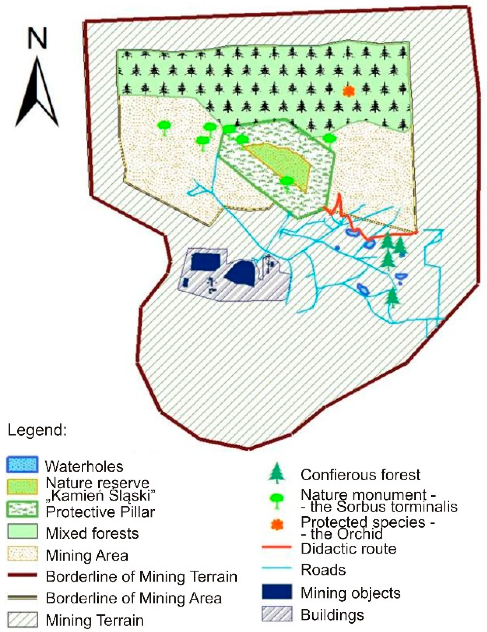
The boundaries of the documented deposit include the protective pillar for the “Kamień Śląski” nature reserve, which prevents full exploitation of the deposit (
Figure 3). This pillar, which covers an area of 61.1 ha, was created for a habitat of a very rare tree species in Poland, known as the wild service tree
Sorbus torminalis, which appears in the area of the mine. This position divides the deposit into two areas: Eastern and Western. The mineral resources deposited in the protective pillar are classified as non-industrial and are not intended for extraction. Therefore, mining is conducted in two excavation sites on two production levels, based on the longwall and deep mining system, and mining progress is directed to the north [
32,
33]. The deposit is excavated by means of drilling and blasting. The mine occasionally also uses mechanical excavation by means of an excavator or a bulldozer. The exploitation is conducted in a longwall system and the mining progress is directed to the north. Through the subsidence of deposits towards the north at angle 2–5°, this results in a systematic decrease in the mine bottom and an increase in mining walls. The excavated material is then transported by trucks for preliminary crushing in crushers, and then by belt conveyors for processing in cement and lime plants. The finished products are used in the lime and cement industry, as well as in both road and residential construction.
In hydrogeological terms, the area of the deposit is divided into three areas: the area of no watering to the bottom of the Górażdże layers (excavation No. 1, exploited in 2005/2006), the second no watering area for the cement industry, as well as the watering area used for the lime industry. The third area, watering in each layer of the deposit, is exploited for the cement and lime industry.
4. Reclamation Directions for the Limestone Mine “Górażdże”
In the Limestone Mine “Górażdże”, the natural environment is affected along the area of 545.5 ha, which is the total area subject to reclamation and the terrain will finally be lowered to 57 m. The existing reclamation project of this enterprise defines the directions of the reclamation as the forestry and water direction, together with the technical and biological reconstruction of embankments and slopes [
32]. The reclamation works on the area of this mine began in 1984 and their final completion is planned in about 60 years, after the exploitation of the deposit resources.
The forest reclamation is carried out in a part of the bottom of the excavation with an area of 254.40 ha (
Figure 4). It also covers the slopes of the excavation and the slopes around the nature reserve. These projects are beneficial for the development of flora and fauna, and will allow for the elimination of earlier dissonance through the restoration and diversification of the landscape and its full adaptation to the environment. The direction of the technical and biological reconstruction of the slopes and embankments of the internal dump is systematically carried out as the exploitation fronts move on. Within the framework of this type of reclamation, protective strips of greenery will be made along the upper edges of the embankment. The biological reclamation activities are aimed at securing and stabilizing the slopes. The implementation of these measures should be carried out within a period of two to five years from the completion of the technical reclamation works. After the exploitation in the northern part of the deposit in the excavation has been finished, the creation of an artificial reservoir with a target area of 211.53 ha is planned. Aquatic reclamation will be carried out in order to develop the fish industry, and thus the resulting water environment will contribute to the improvement of the habitat conditions of living organisms.
Figure 5 shows the current reclamation plan together with the current topography.
The main objective of Górażdże Cement S.A. within the framework of reclamation works and any further development is, first of all, to increase biodiversity and thus minimize natural losses in the area of depleted excavations. This is why a program for the protection of biodiversity of the mining area has been implemented at the mine since 2005; its fundamental objective is to prepare as many diverse habitats as possible, especially for species threatened by the exploitation of carbonate raw materials. The reclamation project proposes that up to 45% of the area requiring revitalization should be reclaimed following the forest reclamation direction, which would also increase the number of habitats that are necessary to increase the number of various species [
32].
5. Proposal to Extend the Scope of Reclamation Operations in the Limestone Mine “Górażdże” in Terms of Preservation of Biodiversity
The analyzed area is mainly characterized by lowlands. Only in the southern part of the mine is there a range of hills. Within the scope of mining activity, the areas are largely forests, while agricultural areas, meadows and pastures are rare. In the central part of the analyzed mining area (i.e., where the environment is directly affected by the mine) there are industrial areas. Triassic formations occur in the area of the mine, and are mainly composed of limestone layers. These Triassic rock formations have a simple, layered structure.
There are no direct reservoirs or watercourses in the vicinity of the mine. The nearest ones are situated 2.5 km from the north side of the documented deposit, in the form of water reservoirs created by artificial lowering of the area of former sand excavation. The water-bearing layer, which is revealed as the mining process progresses, occurs at the depth of shell limestone deposits and has a free character.
The spatial structure of the region is strongly related to industry. There are numerous cement and lime plants nearby, and also areas under legal protection, such as the “St. Anne’s Mountain” Landscape Park with numerous karst forms, the “Ligota Dolna” nature reserve and the protected “Niemodlińskie Forests” landscape. Within the boundaries of the mine, there are forests, and also depleted excavations that form sets of ponds, which are a refuge for numerous and often rare species of plants and animals. Therefore, in order to protect the unique collections of the Sorbus torminalis wild service trees, the “Kamień Śląski” Nature Reserve was created in the “Górażdże” Mine. Around the reserve there are complexes of coniferous stands with a predominance of common pine (Pinus sylvestris) with an admixture of deciduous trees. The mine also has grassy, cultivated and wild vegetation, and there are also inanimate nature monuments, i.e., geological and mineralogical specimens in the form of rock formations, which make the picturesque area more attractive. Valuable specimens of fauna and flora and interesting forms of landscape architecture found in the mine has allowed for the creation of a nature and educational path. The trail includes seven natural sites: natural succession, biodiversity program, pond I, pond II, graceful cattail, karst sinkholes and the “Kamień Śląski” reserve.
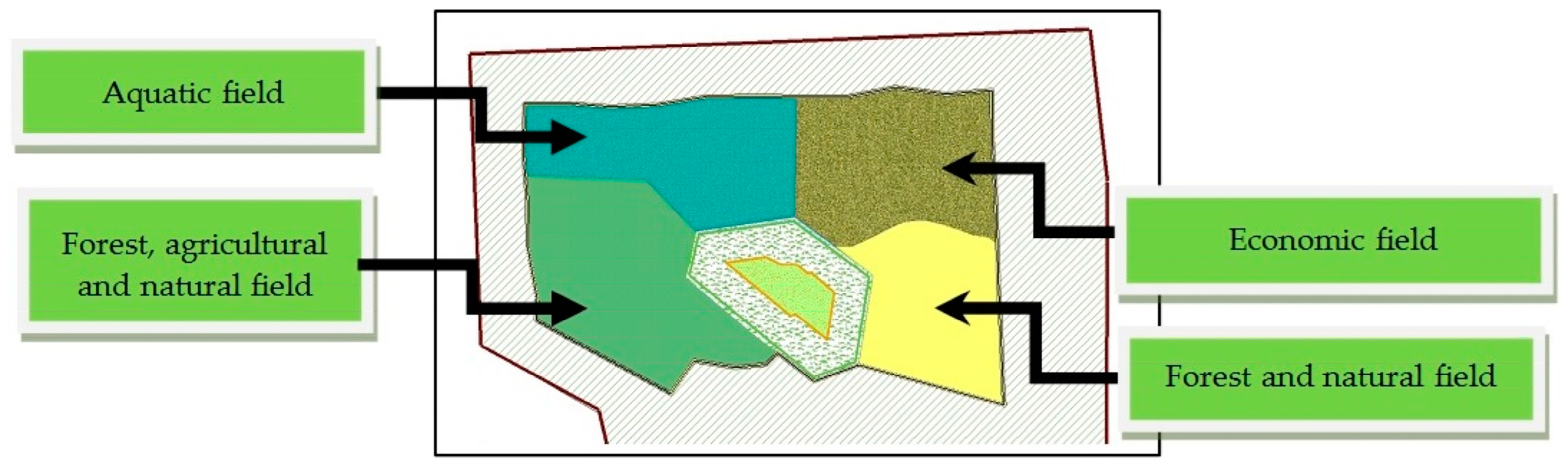
Taking into account the valuable natural properties of the mine area in the form of rare and protected species of fauna and flora and inanimate nature, as well as its recreational and educational potential, it is proposed to extend the current directions of reclamation (forest and aquatic) by introducing the natural, agricultural and economic directions (
Figure 6). As a final result, the area would be a place with forest-meadow and didactic-recreational functions. Additionally, it is proposed that the whole area, after the limestone exploitation is finished, should be legally protected as a geopark with separated protection areas and active geotourism.
The proposed extension of the reclamation directions will not interfere with the current forest direction and will serve to maintain environmental values and extend biodiversity in the depleted area. In the future, after the cessation of mining activity, the reclaimed area will also serve as a place for recreational and tourist purposes.
The natural direction was proposed in order to intensively rebuild biological life, taking into account the preservation and enrichment of the existing biodiversity in the mine area and ensuring the continuity of the existence of species of fauna and flora. It is believed that this direction is appropriate because of the valuable natural values of the Górażdże Mine. The still active limestone mine hides many rare and protected species of fauna and flora (e.g., the wild service tree Sorbus torminalis, bird’s-nest orchid Neottia nidus-avis, white helleborine Cephalathera damasornium, small-leaved helleborine Epipactis microphylla). Apart from the value of animated nature, there are also interesting inanimate nature objects in the mine, such as anthropogenic rock expositions or karst sinkholes.
Within the framework of the introduction of the nature-oriented reclamation direction into the mine area, it is proposed to gradually introduce water habitats in the form of water ponds, as well as rock ponds at steep expositions. Grasslands are also a specific space for the growing of separate plant and animal species. Their introduction into the post-mining areas would meet the main assumption of the mine for the future development of the area, i.e., preservation of biodiversity and enrichment of the post-mining area. It is therefore proposed to introduce the following concepts:
“Górażdże” ecological use—due to the presence of many valuable plant and animal species in the mine areas (ploughman’s-spikenard, stemless thistle, small pondweed, broad-leaved helleborine, downy woundwort, common centaury, smooth snake);
“Orchids” ecological use—due to the translocation and restitution of species, which guarantees durability and protection of places that have rare plant specimens;
Documentation stands of inanimate nature—as a protection of karst sinkholes left as monadnocks in the south-western part of the mine excavation. This form should also cover, for teaching purposes, the geological profiles typical of the quarry.
Extension of the forest and aquatic reclamation directions by recreational and sports functions has been proposed and considers the natural and socio-economic factors included in the management strategy of the commune where the mine is located. The diverse area of the mine floor could serve as a golf course (the minimum area for a nine-hole golf course is between 20 and 30 hectares). In addition, there could be a tennis court and a sports playground nearby, or a properly separated area for a horse stud farm. Alternative sports could also have a place in this area. Apart from the already created didactic path, there could be an extreme bicycle path with steeper descents. The reclamation in the forest direction could be a perfect place to create a rope park, as well as a place for walks, picnics and bicycle trips. The created reservoir could be used as a place for water sports such as diving or sailing (
Figure 7).
Taking into account the guidelines for the creation of a geopark, it can be successfully stated that the Górażdże Mine area will be eligible for the introduction of such a form of protection after the end of its operations and after reclamation in the proposed direction. This area meets all the guidelines for the creation of such a facility: large enough area (over 400 ha), inanimate nature site (in the form of Triassic, anthropogenic geological exposures, diversified terrain relief or karst mine sinkholes), rich natural and ecological value, as well as the specific character of the geological landscape, which is able to provide scientific assistance in geological and environmental education. An additional positive aspect of the introduction of the geopark is the supporting and promoting of social and economic development. The development strategy of the commune presents the concept of promoting the region through tourism and recreation. Stimulating geotourism would promote the region and thus improve the living conditions of the local community, in turn creating new jobs. The form of geological and environmental education made available in the geopark would create an opportunity to satisfy intellectual needs and increase public awareness of geological phenomena that would lead to the formation of a deposit.
6. Conclusions
The proposed proposition of extending the reclamation objectives of the limestone mine “Górażdże” is to maintain the already existing environmental values and extend the biodiversity in the exploited area. On the basis of the presented example shows that anthropogenic activity, which manifests itself in the apparent devastation by the mining industry, consequently brings completely opposite results. Skilful dissemination and the use of the valuable assets of the limestone mine can bring many benefits, such as the creation of new habitats for living organisms and a more varied and much more beautiful landscape overgrown with lush vegetation and extremely rare fauna. The original post-mining landscape architecture enriches and morphologically differentiates the landscape and creates a separate, and even favorable niche for strictly protected organisms that were not previously found in the area. Moreover, the unveiling of interesting geology in the form of walls, e.g., limestone walls on a permanent basis blends into the landscape, creating a harmony with the surroundings. This shows that mining can be environmentally friendly, because if properly designed and implemented, reclamation can contribute to the enhancement of natural values and the perception of mining by the local community. Such areas, apart from having undoubted natural values can also offer places for recreation through the provision of educational, water and sports facilities, especially when they are located in the vicinity of larger urban agglomerations.
Estimation of incomes from the proposed solution seems difficult due to the constant exploitation, however, the currently operating parks in post-mining areas confirm the validity of the proposed solution. Reclamation and development of post-mining areas is a long-term process, but it should be remembered that as a result of the proper design and reclamation of such areas, the overall balance can very often be assessed as positive.


