Geological Hazard Risk Assessment Based on Time-Series InSAR Deformation: A Case Study of Xiaojin County, China
Abstract
1. Introduction
2. Study Area and Data
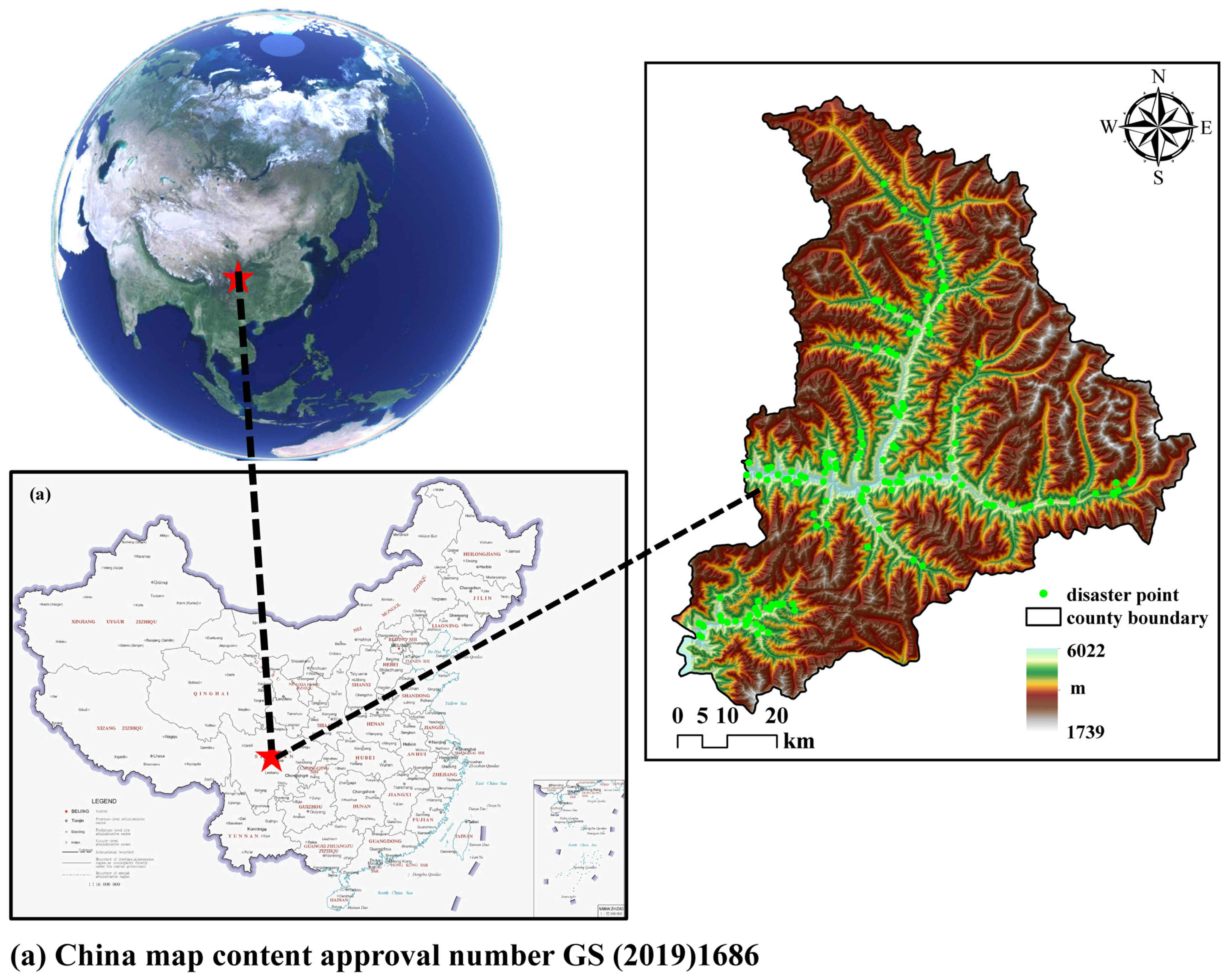
2.1. Study Area
2.2. Data
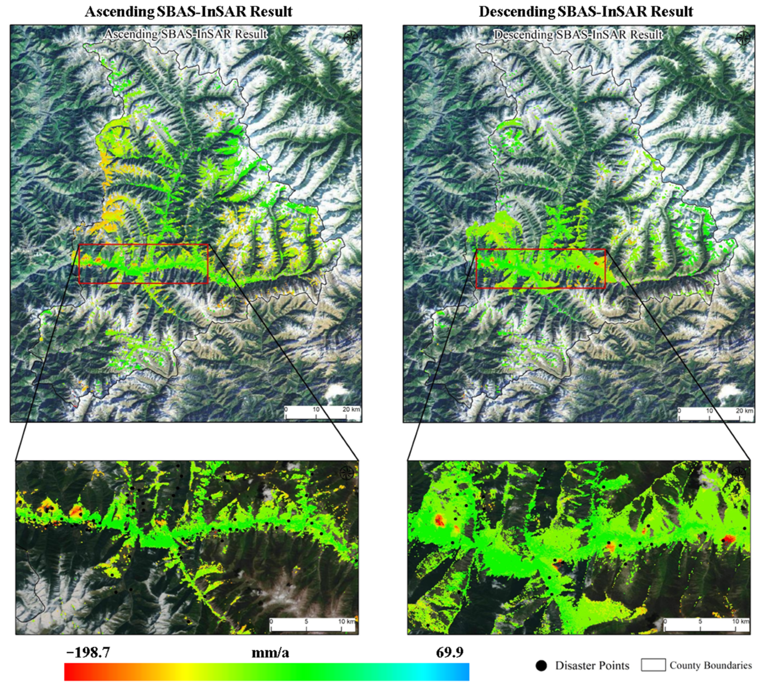
2.3. Preprocessing of Time-Series InSAR Data
3. Establishment of Geological Hazard Risk Assessment Model
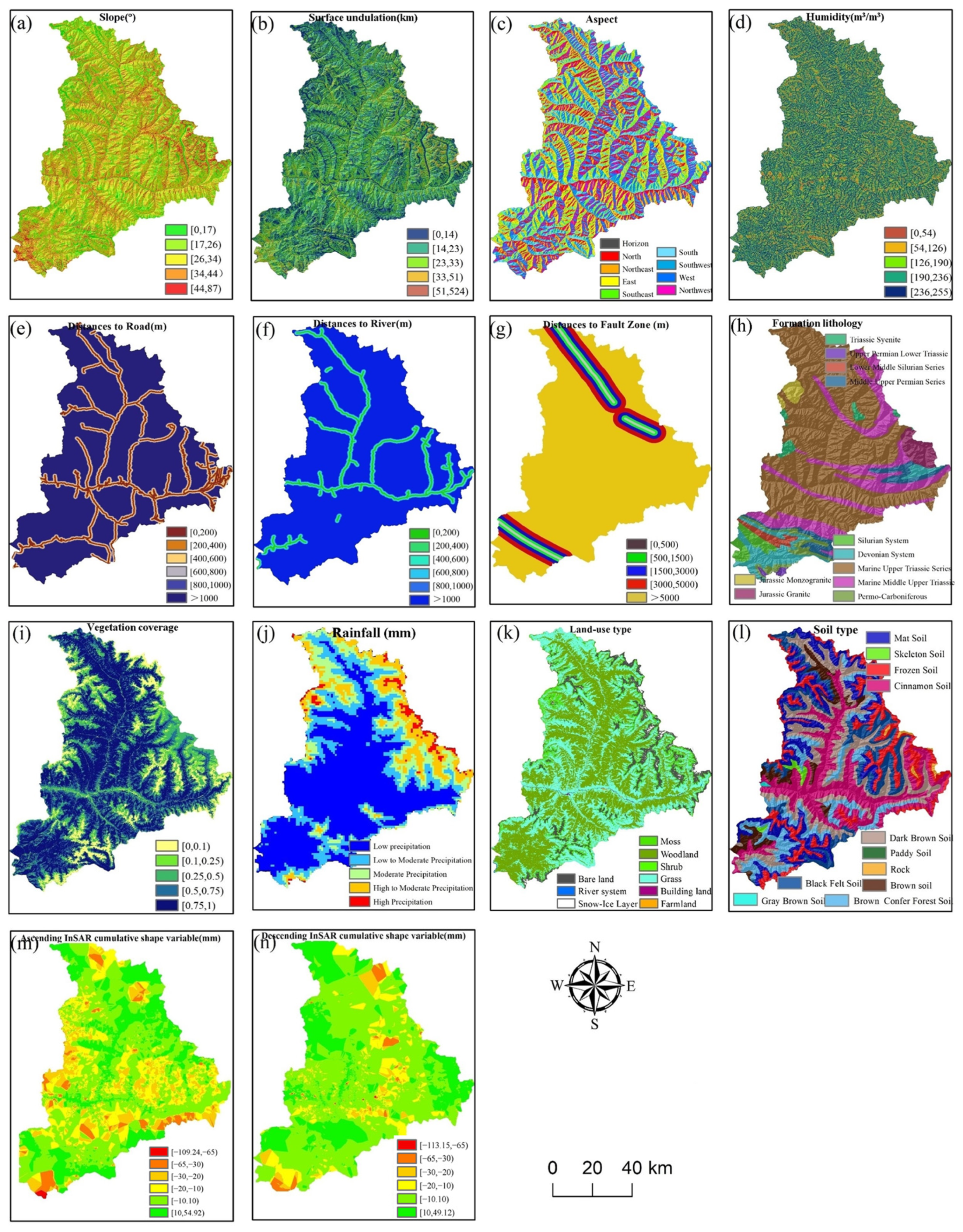
3.1. Evaluation Factors
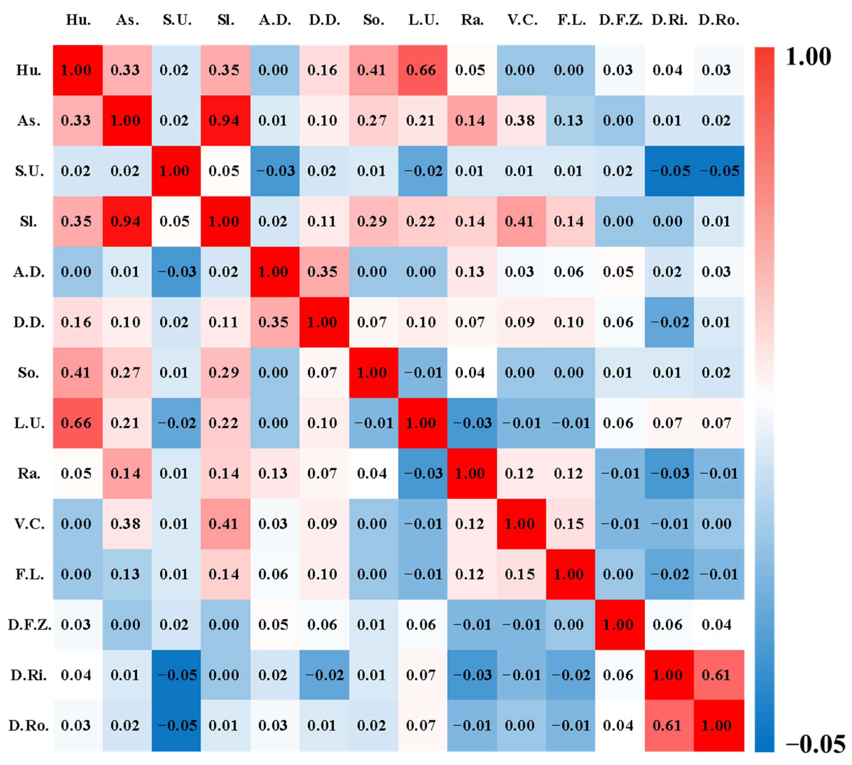
3.2. Factor Selection
3.3. Evaluation Model
3.3.1. Information Volume Model
3.3.2. Evidence Weight Model
4. Results and Accuracy Assessment
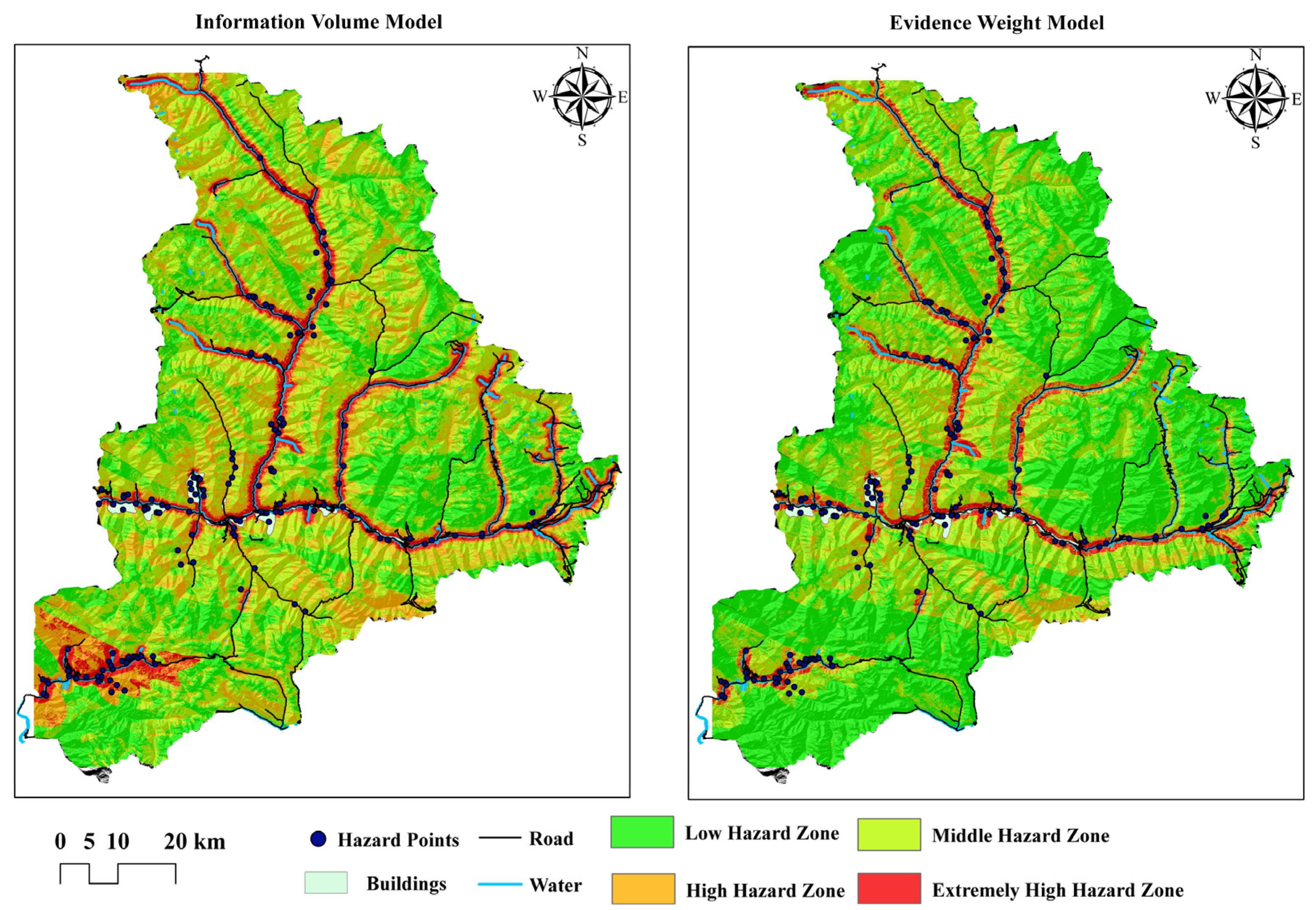
4.1. Results
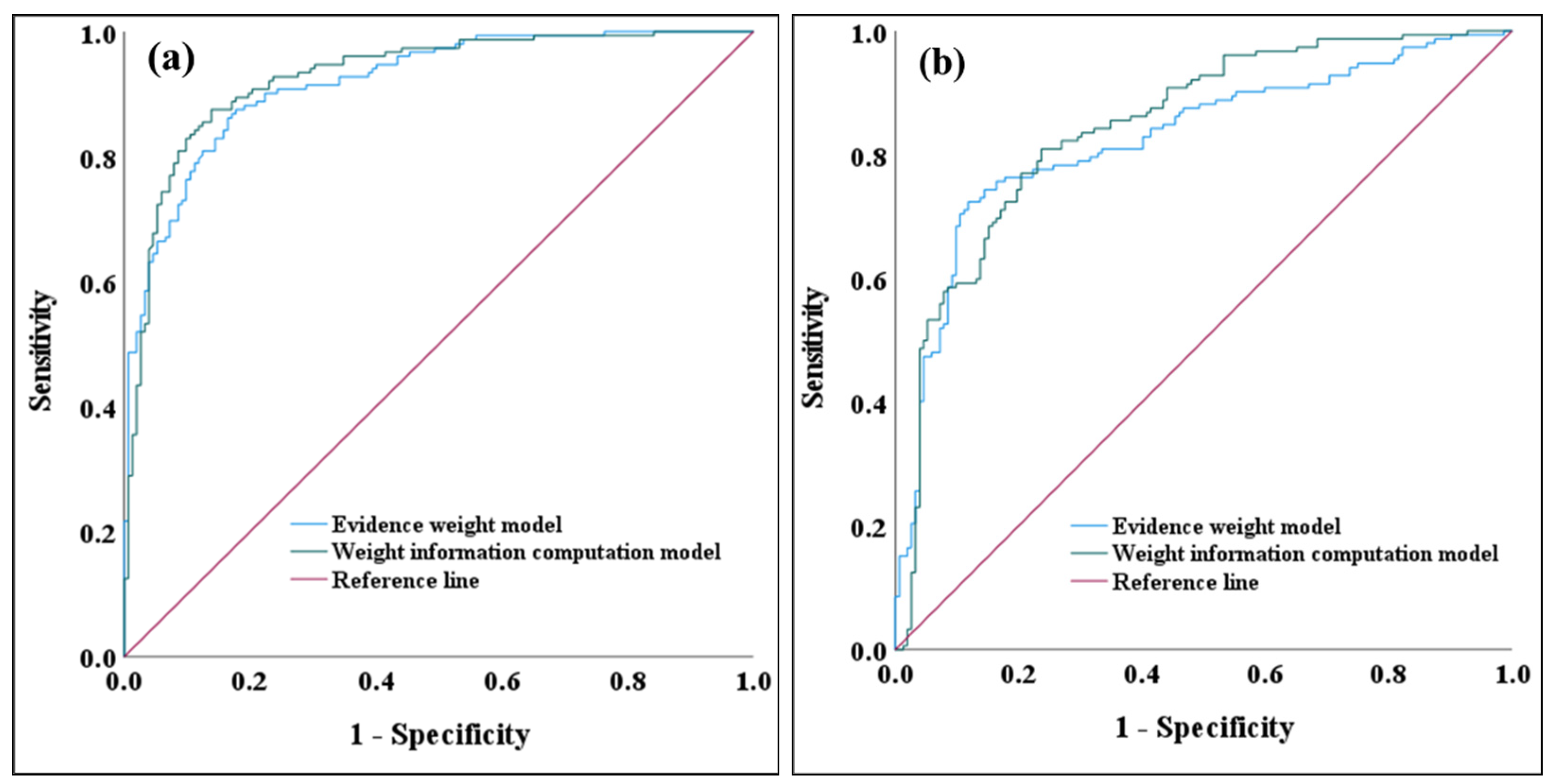
4.2. Accuracy Assessment
5. Conclusions
Author Contributions
Funding
Institutional Review Board Statement
Informed Consent Statement
Data Availability Statement
Acknowledgments
Conflicts of Interest
References
- Zhang, J.; Qian, J.; Lu, Y.; Li, X.; Song, Z. Study on Landslide Susceptibility Based on Multi-Model Coupling: A Case Study of Sichuan Province, China. Sustainability 2024, 16, 6803. [Google Scholar] [CrossRef]
- Cheng, Y.; Gan, Y.; Shi, C.; Huo, A.; Pei, Y.; Song, Y.; Wang, X.; Ahmed, A. A Critical Analysis of Geological Hazard Risk Assessment Including Future Perspectives. Sustainability 2024, 16, 3701. [Google Scholar] [CrossRef]
- Zhang, X.; Jiang, L.; Deng, W.; Shu, Z.; Gao, M.; Liu, G. Risk Assessment of Geological Hazards in the Alpine Gorge Region and Its Influencing Factors: A Case Study of Jiulong County, China. Sustainability 2024, 16, 1949. [Google Scholar] [CrossRef]
- Fan, Z.; Gou, X.; Qin, M.; Fan, Q.; Yu, J.; Zhao, J. Information and logistic regression models based coupl-Ing analysis for susceptibility of geological hazards. J. Eng. Geol. 2018, 26, 340–347. [Google Scholar]
- Dong, J.; Tung, Y.; Chen, C.; Liao, J.; Pan, Y. Logistic regression model for predicting the failure probability of a landslide dam. Eng. Geol. 2011, 117, 52–61. [Google Scholar] [CrossRef]
- Ba, Q.; Chen, Y.; Deng, S.; Wu, Q.; Yang, J.; Zhang, J. An Improved Information Value Model Based on Gray Clustering for Landslide Susceptibility Mapping. ISPRS Int. J. Geo-Inf. 2017, 6, 18. [Google Scholar] [CrossRef]
- Dou, J.; Yunus, A.P.; Tien Bui, D.; Sahana, M.; Chen, C.-W.; Zhu, Z.; Wang, W.; Thai Pham, B. Evaluating GIS-Based Multiple Statistical Models and Data Mining for Earthquake and Rainfall-Induced Landslide Susceptibility Using the LiDAR DEM. Remote Sens. 2019, 11, 638. [Google Scholar] [CrossRef]
- Wang, Y.; Nanehkaran, Y.A. GIS-based fuzzy logic technique for mapping landslide susceptibility analyzing in a coastal soft rock zone. Nat. Hazards 2024, 120, 10889–10921. [Google Scholar]
- Wei, A.; Li, D.; Zhou, Y.; Deng, Q.; Yan, L. A novel combination approach for karst collapse susceptibility assessment using the analytic hierarchy process, catastrophe, and entropy model. Nat. Hazards 2021, 105, 405–430. [Google Scholar]
- Hu, S.; Cao, M.; Li, T.; Qiu, H.; Zhang, Z.; Liu, Q.; Bao, Y. Danger assessment of earthquake-induced geological disasters in Shaanxi Province based on AHP and GIS. Quat. Sci. 2014, 34, 336–345. [Google Scholar]
- Zheng, Z.; Xie, C.; He, Y.; Zhu, M.; Huang, W.; Shao, T. Monitoring Potential Geological Hazards with Different InSAR Algorithms: The Case of Western Sichuan. Remote Sens. 2022, 14, 2049. [Google Scholar] [CrossRef]
- Dai, K.; Chen, C.; Shi, X.; Wu, M.; Feng, W.; Xu, Q.; Liang, R.; Zhuo, G.; Li, Z. Dynamic landslides susceptibility evaluation in Baihetan Dam area during extensive impoundment by integrating geological model and InSAR observations. Int. J. Appl. Earth Obs. Geoinf. 2023, 116, 103157. [Google Scholar] [CrossRef]
- Zhong, J.; Li, Q.; Zhang, J.; Luo, P.; Zhu, W. Risk Assessment of Geological Landslide Hazards Using D-InSAR and Remote Sensing. Remote Sens. 2024, 16, 345. [Google Scholar] [CrossRef]
- Du, Z.; Ge, L.; Ng, A.; Zhu, Q.; Horgan, F.; Zhang, Q. Risk assessment for tailings dams in Brumadinho of Brazil using InSAR time series approach. Sci. Total Environ. 2020, 717, 137125. [Google Scholar] [CrossRef]
- Ge, Q.; Sun, Q.; Zhang, N.; Hu, J. Evaluation of Geological Hazard Susceptibility of Baiyin City Based on Multi-temporal InSAR Deformation Measurements. Geomat. Inf. Sci. Wuhan Univ. 2024, 49, 1434–1443. [Google Scholar]
- Gao, B.; He, Y.; Zhang, L.; Yao, S.; Yang, W.; Chen, Y.; He, X.; Zhao, Z.; Chen, H. Dynamic evaluation of landslide susceptibility by CNN considering InSAR deformation: A case study of Liujiaxia reservoir. Chin. J. Rock Mech. Eng. 2023, 42, 450–465. [Google Scholar]
- Yuan, R.; Chen, J. A hybrid deep learning method for landslide susceptibility analysis with the application of InSAR data. Nat. Hazards 2022, 114, 1393–1426. [Google Scholar] [CrossRef]
- Novellino, A.; Cesarano, M.; Cappelletti, P.; Martire, D.; Napoli, M.; Ramondini, M.; Sowter, A.; Calcaterra, D. Slow-moving landslide risk assessment combining Machine Learning and InSAR techniques. Catena 2021, 203, 105317. [Google Scholar] [CrossRef]
- Carl, T.; Intrieri, E.; Raspini, F.; Bardi, F.; Farina, P.; Ferretti, A.; Colombo, D.; Novali, F.; Casagli, N. Perspectives on the prediction of catastrophic slopefailures from satellite InSAR. Sci. Rep. 2019, 9, 14137. [Google Scholar]
- Lu, P.; Catani, F.; Tofani, V.; Casagli, N. Quantitative hazard and risk assessment for slow-moving landslides from Persistent Scatterer Interferometry. Landslides 2014, 11, 685–696. [Google Scholar] [CrossRef]
- Ciampalini, A.; Raspini, F.; Lagomarsino, D.; Catani, F.; Casagli, N. Landslide susceptibility map refinement using PSInSAR data. Remote Sens. Environ. 2016, 184, 302–315. [Google Scholar]
- Li, J.; Jin, G.; Xiong, X.; Zhou, L.; Ye, H.; Shi, Q.; Yang, H. Surface time series response and deformation cause analysis in 2021 Zhengzhou extreme weather, China. Earth Space Sci. 2024, 11, 3643. [Google Scholar] [CrossRef]
- Li, J.; Zhou, L.; Zhu, Z.; Qin, J.; Xian, L.; Zhang, D.; Huang, L. Surface Deformation Mechanism Analysis in Shanghai Areas Based on TS-InSAR Technology. Remote Sens. 2022, 14, 4368. [Google Scholar] [CrossRef]
- Zhao, Y.; Zhou, L.; Wang, C.; Li, J.; Qin, J.; Sheng, H.; Huang, L.; Li, X. Analysis of the Spatial and Temporal Evolution of Land Subsidence in Wuhan, China from 2017 to 2021. Remote Sens. 2022, 14, 3142. [Google Scholar] [CrossRef]
- Li, J.; Zhou, L.; Ren, C.; Liu, L.; Zhang, D.; Ma, J.; Shi, Y. Spatiotemporal Inversion and Mechanism Analysis of Surface Subsidence in Shanghai Area Based on Time-Series InSAR. Appl. Sci. 2021, 11, 7460. [Google Scholar] [CrossRef]
- Escanoglu, M.; Gokceoglu, C. Assessment of landslide susceptibility for a landslide-prone area (north of Yenice, NW Turkey) by fuzzy approach. Environ. Geol. 2002, 41, 720–730. [Google Scholar]
- Oh, H.; Pradhan, B. Application of a neuro-fuzzy model to landslide-susceptibility mapping for shallow landslides in a tropical hilly area. Comput. Geosci. 2011, 37, 1264–1276. [Google Scholar]
- Wang, B.; Ma, X.; Shao, C.; Song, W.; Lv, F. Risk assessment of ground fissures based on AHP and information method. Explor. Eng. (Rock Soil Drill. Tunneling) 2018, 45, 91–96. [Google Scholar]
- Du, Q.; Fan, W.; Li, K.; Yang, D.; Lv, J. Geohazard susceptibility assessment by using binary logical regression and information value model. J. Catastrophology 2017, 32, 220–226. [Google Scholar]
- Kumar, R.; Anbalagan, R. Landslide susceptibility mapping using analytical hierarchy process (AHP) in Tehri reservoir rim region, Uttarakhand. J. Geol. Soc. India 2016, 87, 271–286. [Google Scholar]
- Liu, R.; Xin, Y.; Li, Y. Dynamic signature verification method based on Pearson correlation coefficient. Chin. J. Sci. Instrum. 2022, 43, 279–287. [Google Scholar]
- Shannon, C. A mathematical theory of communication. Bell Syst. Tech. J. 1948, 27, 379–423. [Google Scholar]
- Li, R.; Tan, S.; Zhang, M.; Zhang, S.; Wang, H.; Zhu, L. Geological Disaster Susceptibility Evaluation Using a Random Forest Empowerment Information Quantity Model. Sustainability 2024, 16, 765. [Google Scholar] [CrossRef]
- Xu, W.; Yu, W.; Jing, S.; Zhang, G.; Huang, J. Debris flow susceptibility assessment by GIS and information value model in a large-scale region, Sichuan Province (China). Nat. Hazards 2013, 65, 1379–1392. [Google Scholar]
- Zhang, G.; Wang, S.; Chen, Z.; Liu, Y.; Xu, Z.; Zhao, R. Landslide susceptibility evaluation integrating weight of evidence model and InSAR results, west of Hubei Province, China. Egypt. J. Remote Sens. Space Sci. 2023, 26, 95–106. [Google Scholar]
- Goyes-Peñafiel, P.; Hernandez-Rojas, A. Landslide susceptibility index based on the integration of logistic regression and weights of evidence: A case study in Popayan, Colombia. Eng. Geol. 2021, 280, 105958. [Google Scholar]
- Jiang, W.G.; Rao, P.Z.; Cao, R.; Tang, Z.H.; Chen, K. Comparative evaluation of geological disaster susceptibility using multi-regression methods and spatial accuracy validation. J. Geogr. Sci. 2017, 27, 439–462. [Google Scholar] [CrossRef]
- Wang, X.D.; Zhang, C.B.; Wang, C.; Liu, G.W.; Wang, H.X. GIS-based for prediction and prevention of environmental geological disaster susceptibility: From a perspective of sustainable development. Ecotoxicol. Environ. Saf. 2021, 226, 112881. [Google Scholar]
| Data | Evaluation Factors | Resolution | Data Source |
|---|---|---|---|
| Sentinel-1A | InSAR deformation | 20 m | https://dataspace.copernicus.eu/ (accessed on 10 May 2023) |
| DEM | Slope, aspect, and terrain undulation | 30 m | http://srtm.csi.cgiar.org/srtmdata (accessed on 10 May 2023) |
| Stratigraphic lithology | Stratigraphic lithology | 2 km | https://www.ngac.cn/ (accessed on 12 May 2023) |
| Fault zone | Distance from the fault zone | 2 km | https://www.ngac.cn/ (accessed on 10 June 2023) |
| Land use | Land use type | 10 km | https://viewer.esa-worldcover.org/worldcover/ (accessed on 20 May 2023) |
| Soil types | Soil types | 1 km | https://www.resdc.cn/ (accessed on 23 May 2023) |
| River | Distance from river | 1 km | https://www.openstreetmap.org/ (accessed on 10 June 2023) |
| Road | Distance from road | 1 km | https://www.openstreetmap.org/ (accessed on 10 June 2023) |
| Landsant8 | Vegetation coverage | 30 m | http://www.gscloud.cn/ (accessed on 5 June 2023) |
| Rainfall data | Annual average rainfall | 1 km | http://data.cma.cn (accessed on 12 June 2023) |
| Parameters | Description |
|---|---|
| Satellite | Sentinel-1A |
| Imaging mode | IW |
| Data type | SLC |
| Band | C |
| Revisit cycle | 12 days |
| Polarization | VV |
| Time span | January 2021–December 2021 |
| Orbit direction Central incidence angle on the test site | Ascending and Descending 33.7° and 35.3° |
| Number of scenes | 23 and 23 |
| Hazard Level | Area Ratio (IVM) | Area Ratio (EWM) | NEGHP (IVM) | NEGHP (EWM) | PEGHP (IVM) | PEGHP (EWM) | NEGHPA (IVM) | NEGHPA (EWM) |
|---|---|---|---|---|---|---|---|---|
| Low hazardous area | 27.28% | 50.93% | 1 | 4 | 0.66% | 2.63% | 0.0007 | 0.0014 |
| Medium hazardous area | 43.14% | 33.18% | 13 | 18 | 8.55% | 11.84% | 0.0055 | 0.0099 |
| High hazardous area | 19.36% | 9.04% | 27 | 40 | 17.76% | 26.32% | 0.0255 | 0.0809 |
| Extremely hazardous area | 10.22% | 6.85% | 111 | 90 | 73.03% | 59.21% | 0.1986 | 0.2403 |
Disclaimer/Publisher’s Note: The statements, opinions and data contained in all publications are solely those of the individual author(s) and contributor(s) and not of MDPI and/or the editor(s). MDPI and/or the editor(s) disclaim responsibility for any injury to people or property resulting from any ideas, methods, instructions or products referred to in the content. |
© 2025 by the authors. Licensee MDPI, Basel, Switzerland. This article is an open access article distributed under the terms and conditions of the Creative Commons Attribution (CC BY) license (https://creativecommons.org/licenses/by/4.0/).
Share and Cite
Li, J.; Yan, Z.; Tong, L.; Wang, Y.; Yu, S. Geological Hazard Risk Assessment Based on Time-Series InSAR Deformation: A Case Study of Xiaojin County, China. Appl. Sci. 2025, 15, 4143. https://doi.org/10.3390/app15084143
Li J, Yan Z, Tong L, Wang Y, Yu S. Geological Hazard Risk Assessment Based on Time-Series InSAR Deformation: A Case Study of Xiaojin County, China. Applied Sciences. 2025; 15(8):4143. https://doi.org/10.3390/app15084143
Chicago/Turabian StyleLi, Jiancun, Zhao Yan, Liqiang Tong, Yi Wang, and Shangyuan Yu. 2025. "Geological Hazard Risk Assessment Based on Time-Series InSAR Deformation: A Case Study of Xiaojin County, China" Applied Sciences 15, no. 8: 4143. https://doi.org/10.3390/app15084143
APA StyleLi, J., Yan, Z., Tong, L., Wang, Y., & Yu, S. (2025). Geological Hazard Risk Assessment Based on Time-Series InSAR Deformation: A Case Study of Xiaojin County, China. Applied Sciences, 15(8), 4143. https://doi.org/10.3390/app15084143


