Article

Bringing Light into the Darkness: Integrating Light Painting and 3D Recording for the Documentation of the Hypogean Tomba dell’Orco, Tarquinia

by
Matteo Lombardi
1,†,
Maria Felicia Rega
2,†,
Vincenzo Bellelli
3,
Riccardo Frontoni
4,
Maria Cristina Tomassetti
3 and
Daniele Ferdani
2,*
1
Italian National Research Council, Institute of Heritage Science (CNR-ISPC), 85050 Potenza, Italy
2
Italian National Research Council, Institute of Heritage Science (CNR-ISPC), 00010 Montelibretti, Italy
3
Parco Archeologico di Cerveteri e Tarquinia, 01016 Tarquinia, Italy
4
Ales—Arte Lavoro e Servizi S.p.A., 00184 Rome, Italy
*
Author to whom correspondence should be addressed.
These authors contributed equally to this work as first authors.
Appl. Sci. 2025, 15(23), 12463; https://doi.org/10.3390/app152312463 (registering DOI)
Submission received: 22 October 2025 / Revised: 13 November 2025 / Accepted: 17 November 2025 / Published: 24 November 2025

Abstract

The three-dimensional documentation of hypogean structures poses significant methodological challenges due to the absence of natural light, confined spaces, and the presence of fragile painted surfaces. This study presents an integrated workflow for the survey of the Tomba dell’Orco (Tarquinia), combining terrestrial laser scanning, photogrammetry, and the light painting technique. Borrowed from photographic practice, light painting was employed as a dynamic lighting strategy during photogrammetric acquisition to overcome issues of uneven illumination and harsh shadows typical of underground environments. By moving handheld LED sources throughout long-exposure shots, operators produced evenly illuminated images suitable for feature extraction and high-resolution texture generation. These image datasets were subsequently integrated with laser scanning point clouds through a structured pipeline encompassing registration, optimization, and texture reprojection, culminating in web dissemination via the ATON framework. The methodological focus demonstrates that light painting provides a scalable and replicable solution for documenting complex hypogean contexts, improving the photometric quality and surface readability of 3D models while reducing acquisition time compared to static lighting setups. The results highlight the potential of dynamic illumination as an operational enhancement for 3D recording workflows in low-light cultural heritage environments.

1. Introduction

The metrological survey of hypogean environments within the Cultural Heritage (CH) sector represents a complex and delicate task, often challenged by multiple constraints. From the structure’s intricate architectural layout and the absence of natural lighting to the presence of fragile interior painted decorations, the critical issues to be addressed are often numerous, highly specific to each case study and, above all, dependent on the intended purpose of the survey. In specific cases, such as hypogean structures like chamber tombs, the critical issues encountered involve multiple aspects that affect both the documentation process and public accessibility. Their walls are frequently adorned with painted decorations that require rigorous and carefully structured steps for accurate documentation [1]. Simultaneously, access to these spaces is often restricted for safety or conservation reasons. The preservation of pigments, for instance, depends on a delicate microclimate that can be disrupted by stress factors such as humidity fluctuations or visitor traffic [2]. In other cases, access may be limited due to restoration work on structures that require particular care and attention. All of these constraints highlight the need for carefully planned, well-calibrated and highly thorough survey strategies. Moreover, it is increasingly evident that the motivations driving such surveys extend well beyond the metrological acquisition of 3D point clouds. In fact, they must also produce photorealistic 3D models with high-resolution textures to: (a) ensure faithful documentation of mural paintings and (b) support web-based virtual visits for broader audiences [3]. The integration of Terrestrial Laser Scanning (TLS) with photogrammetry has become a well-established standard in CH documentation workflows, proving to be the most effective solution for overcoming previous limitations in documenting large and complex heritage sites [2,4,5,6,7]. These two methods complement each other and, when properly combined, they enable the documentation process to better capture the complexity and uniqueness of heritage subjects [8]. Laser scanning provides highly accurate and dense point cloud data, capturing the geometric structure of the environment with precision. In contrast, photogrammetry is more effective at capturing high-resolution texture and color information [7,9,10]. However, the integration of these methods is not always straightforward, especially in hypogean environments characterized by complex underground layouts and an absence of natural light. The limited or uneven artificial lighting in such spaces, often with overly cold or warm color temperatures, creates harsh shadows that complicate photogrammetric acquisition [11,12]. This necessitates the use of tailored artificial lighting setups, which, depending on the site’s layout, may vary in number and placement. These setups often only illuminate small portions of the space at a time, potentially introducing inconsistencies, gaps, and shadows that must be corrected manually during further post-processing steps [6]. The issue behind artificial lighting, particularly as it relates to feature recognition and enhancement for photogrammetric purposes, is a central topic that has prompted a range of reflections, primarily focused on mobile heritage assets [13,14]. Only recently has the heritage sector begun to recognize a broader array of potential solutions that could be applied to the 3D documentation of underground environments [14]. Among these techniques, light painting stands out as a well-established method in the fields of photography and visual arts. It focuses on the dynamic manipulation of artificial light during field data acquisition [15,16,17]. The technique relies on the use of an oriented light source which, combined with long exposure times, creates a highlighted chiaroscuro effect on poorly illuminated objects [13]. At the core of this method is the transformation of the light source from a static element into a dynamic tool. This approach allows for the enhancement of geometric and textural features of the subject, effectively reversing the conventional paradigms of photogrammetric data acquisition. Although well-documented in the literature and commonly applied to small-scale objects, the technique’s potential is flexible and scalable, making it suitable for more complex scenarios where static artificial lighting proves challenging. The technical issue of lighting is closely linked to the need to produce photorealistic 3D models that can also be made accessible to the public. In this scenario, the ATON platform offers a robust and high-performance solution [18]. ATON is an open-source framework developed by CNR-ISPC, which builds on established web standards, such as the glTF file format and multiresolution models, as well as widely adopted libraries like Three.js and Node.js [18,19]. It provides advanced functionalities for Web3D/WebXR 3D visualisation, annotation, immersive interaction, and real-time collaboration. Thanks to its modular design and architecture, it allows for the rapid development and deployment of custom interactive web applications tailored to specific requirements, without the need for installation by end users [19]. For these reasons, ATON was selected for the online dissemination and valorisation of the 3D data generated in this study. This paper presents the methodological framework adopted for the integrated 3D documentation of the hypogean tomb known as Tomba dell’Orco, located in Tarquinia. The project serves multiple purposes: documenting the current state of conservation, supporting future restoration and monitoring efforts, and enabling virtual access to a space currently closed to the public. Special attention is given to the application of light painting techniques to enhance the photogrammetric acquisition in a particularly challenging underground context. The case study was selected following the results of the 2023 third national call for access to the mobile laboratories of E-RIHS.it, in which the project Etruscan.Pro.Tech—New acquisitions for the study of the development of the execution technique and for promoting the Etruscan mural painting in Tarquinia was selected among the winners, and pursuant to the Access Molab agreement, a survey campaign was carried out during the period 10–11 June 2024. One of the main objective of the Etruscan.Pro.Tech project was to produce a comprehensive three-dimensional documentation aimed at promoting access, knowledge dissemination, and the cultural valorisation of the wall paintings through the high-resolution 3D model of the interior rooms of the Tomba dell’Orco.

2. Materials and Methods

In this scenario, one of the specific goals was to generate a digital model accessible and viewable across multiple devices, by publishing it on a Web3D platform (e.g., ATON framework). Achieving this goal requires complying with a thorough methodological approach, adapted to adhere to the case study’ specifics, that starts with the selection of appropriate acquisition techniques and culminates with the optimization of the geometry and export in a format that ensures its usability on a 3D web application. This integrated approach is mandatory to create a digital replica of the site that meets the highest standards of geometric accuracy, completeness, and photorealism, ensuring a faithful representation of the tomb’s structure as much as the fidelity representation of its material components and decorations (e.g., wall paintings, frescoes and so on). The objective of this study is to address the challenges related to the conservation, monitoring, and accessibility of a historically significant monument which, due to its physical inaccessibility, presents considerable obstacles both for collecting the metrological data required for proper restoration and for enabling public engagement. The presence of frescoes exposed to a humid environment that is potentially damaging to the artworks requires innovative strategies for environmental monitoring and the prevention of deterioration. It is important to note that the low-light conditions present at the site constitute an additional complication, with a consequent hindrance to both scientific documentation and the visual appreciation of the heritage asset. The research questions guiding this study are therefore as follows:
  • What is the most effective approach for collecting metrological data and acquiring color information through 3D recording of a cultural heritage hypogean structure? Could the integration of dynamic lighting techniques provide new tools to overcome the challenges posed by such underground and poorly lit environments?
  • What technologies might facilitate the effective documentation and monitoring of frescoes within a humid and poorly lit environment?
  • How can an integrated approach—combining advanced digital documentation, remote sensing systems, and virtual access solutions—contribute to the conservation and enhancement of cultural heritage in such challenging conditions?
  • What strategies can be implemented to ensure visitor engagement with a monument that cannot be directly accessed?

2.1. Case Study

The Tomb was discovered in the second half of the nineteenth century during the construction of the municipal cemetery and excavated starting from 1868 [20]. It is considered to be one of the most complex tombs in the Monterozzi Necropolis in Tarquinia, both from an architectural point of view and in terms of its pictorial decoration, which was created at different times [21]. The subterranean chamber complex consists of multiple rooms, formed by excavating the natural rock formation that constitutes the plateau in closest proximity to the coastline. This geological feature offers a protective barrier to the hill behind it, which formerly supported the ancient city of Tarquinia (Tarχna in Etruscan). The city became the preferred burial site for its population. The Monterozzi Necropolis, deriving its name from the substantial number of burial mounds discovered in the subterranean areas in past centuries, now contains more than 6000 hypogean sepulchres and extends across the entire plateau, covering a linear length of approximately 3 km from east to west. The natural bank exhibits an alternation of layers of organogenic calcarenite, locally designated as macco, with yellow quartz deposits that are cohesive due to the effects of moisture and pressure, and referred to as sabbione [22]. Up to this date, three tombs have been identified in the sandstone layer: Tomba dell’Orco, Tomba degli Scudi and Tomba del Cardinale. These tombs were constructed between the 4th and 3rd centuries BC and are located in the same area as the modern cemetery of Tarquinia (Figure 1), known as Primi Archi. The Tomba dell’Orco is located beneath the cemetery, and is accessed through a dromos measuring approximately 17 m in length. This dromos is reached through an opening in the eastern boundary wall. The two primary chambers of the hypogeum (Figure 2) were excavated more than a century apart, at the behest of members of one of the most prominent families of the fifth and fourth centuries BC, the Spurinnas [23]. In recognition of their distinguished contributions to politics and military endeavours, a select group of individuals were honoured with the installation of a commemorative sculpture group, accompanied by a dedicatory inscription, within the hallowed precincts of the Civitas [24]. The older of the two rooms, designated as Orco I, was constructed between 380 and 350 BC, marking the midpoint of the Classical period, while the second, Orco II, was built between 340 and 325 BC, at the inception of the Hellenistic period. It is reasonable to hypothesise that the two chambers were originally separate from each other, given the temporal discrepancy and the existence of separate access corridors [25]. The dromos of the second room is completely buried. We do not know if it was ever excavated, but fragments of painted plaster are visible in section, which could belong to the decoration of the door intrados or the first part of the dromos itself. The aristocratic need, arising from the socio-economic changes induced by the encounter-clash with Rome, to expand the burial space in order to ensure family continuity, no longer for one or two generations, but for four or five, led the descendants of Velthur I Spurinna, owner of the first chamber, to join the two spaces, first with a passageway, and then by completely demolishing the dividing walls [26]. This development thus resulted in the formation of a transitional corridor (designated as Orco III by certain scholars) between the two hypogea [21,27]. The rooms appear to function as sacred spaces, having been designed according to the principles of chthonic architecture, with corners oriented according to sacred and symbolic parameters. The walls are decorated with frescoes of high artistic and technical quality. The first chamber shows afterlife scenes, such as the banquet of the tomb’s owners, depicting at least three generations: the grandchildren respectfully admire their grandparents, and the famous Velia Spurinna, the “Mona Lisa of Etruria”, possibly the daughter of Velthur I, wife of one of the members of the Velcha family, known for commissioning, a few years later, the Tomba degli Scudi [21,28,29]. In the corridor between the two sepulchres, there is an impressive mythological scene depicting the blinding of the cyclops Polyphemus by Odysseus, a significant prelude to the pictorial cycle in the second chamber. This cycle is characterised by its faithful depictions of the realm of the Underworld, with naturalistic representations such as rocks and swamps, as well as the characters who inhabit it, once again according to Greek mythology. The rulers of the Underworld, Hades and Persephone, are depicted in regal poses, accompanied by guardians of the underworld, such as Geryon, Cerberus and winged demons from Etruscan tradition, as well as heroes such as Ajax, Agamemnon and Theseus, and the soothsayer Tiresias, surrounded by “whirling animals”. The relief decoration on the base of the pillar in front of Hades and Persephone is of particular interest, as it has not previously been considered. The relief simulates a rock base through an irregular surface and moulded plaster. The Tomba dell’Orco has been the subject of a long and careful restoration project carried out by the Central Institute for Restoration [30]. The restoration campaign, which also involved ICR students in various educational projects, took place in all its phases from 1996 to 2005 under the direction of Dr Giovanna De Palma. The Institute was responsible for all preliminary investigations, including those to determine the structural safety of the environment, up to the installation of the new lighting system, which is still in use today. Like all hypogea in the Monterozzi necropolis assigned to the Archaeological Park of Cerveteri and Tarquinia (PACT), the tomb is constantly monitored [31]. The fact that it was excavated from a sandstone bank undoubtedly facilitated the excavation process, as evidenced by the highly refined coffered ceilings and cornices, which have not been covered with plaster. However, this also explains the current state of preservation [22]. The surfaces unprotected by mortar layers and prone to gravitational detachment continue to exhibit exfoliation phenomena. Specifically, the decoration of the ceiling of the chamber designated as Orco II has now nearly completely disappeared, with only remnants remaining in the north-western corner. There are numerous cracks that run parallel to the surface, which require monitoring due to the potential for further rockfalls. In this delicate conservation context, the creation of 3D documentation is of strategic importance as the most effective method for recording the current situation, documenting it and making it available for comparisons over time and for studying consolidation and protection methods and models. A detailed virtual copy can also be used to simulate restoration work.
The 3D documentation activity was conceived by PACT as an indispensable aid to the monitoring, preventive conservation and documentation of all the hypogea under its jurisdiction. There are currently 37 hypogea under the responsibility of the PACT, 33 of which can be visited daily or during special openings. The first model, created in collaboration with CNR-ISPC, focused on the most famous tomb in Tarquinia. The hypogeum was selected as the first case study precisely because of its architectural complexity and the fact that it is not normally open to the public for conservation reasons, as well as for its archaeological and artistic value. Thanks to 3D navigation, which will soon be available at the Archaeological Museum of Tarquinia via VR headsets and on the museum’s website, visitors will be able to take a unique journey into the Greek-Etruscan underworld. This will promote the dissemination and understanding of the culture and ideas expressed through architecture and painting. The aim is to create high-quality 3D models of all the other hypogea, documenting the entire heritage. Last but not least, the new and dangerous threat posed by rapid climate change is a major concern. This will soon force us to make every effort to protect fragile underground environments and devise new insulation strategies for underground chambers.

2.2. Methodology

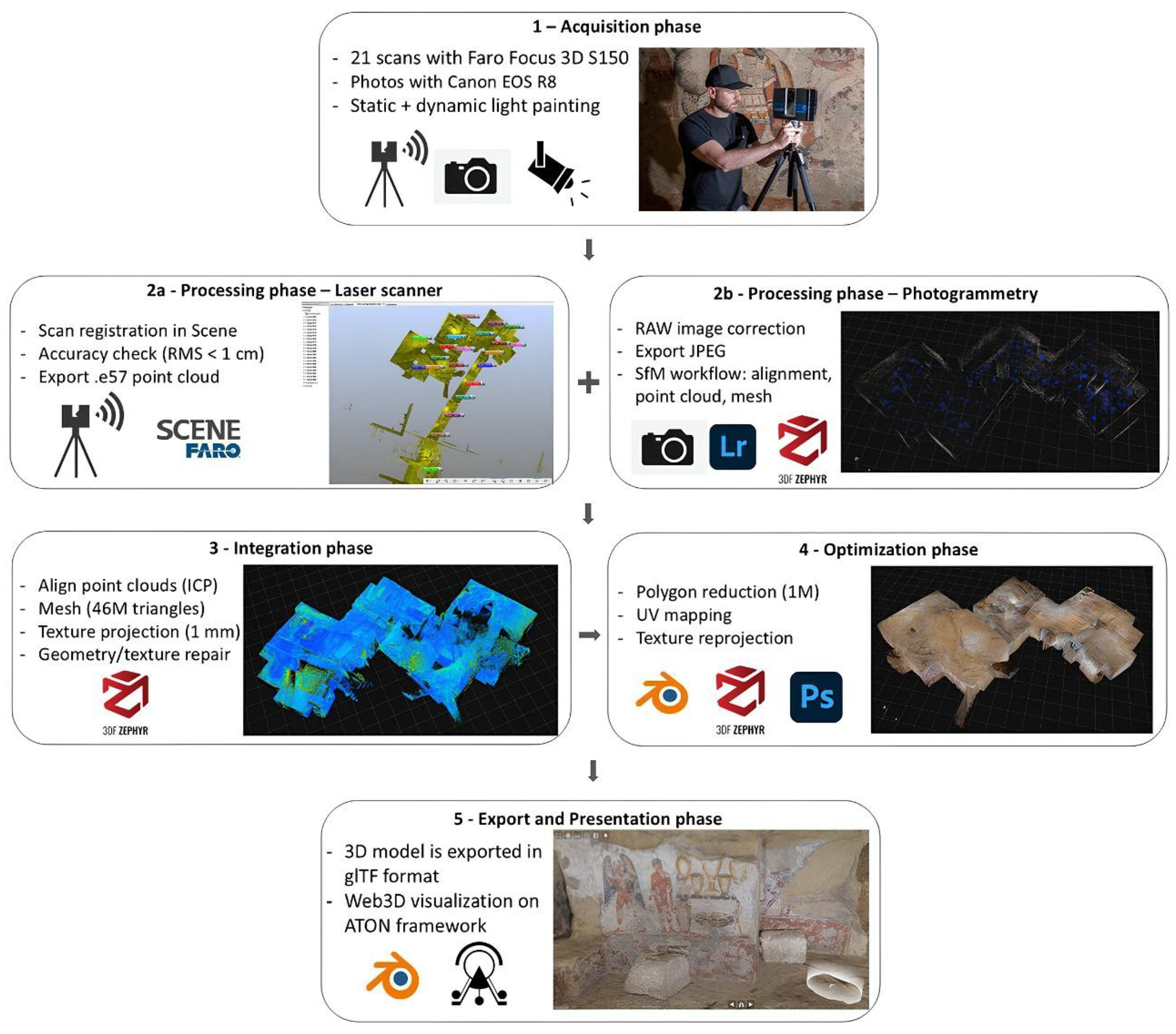
The workflow was organised into 5 main phases, as shown in Figure 3, following a well-established protocol [32,33] adapted to the specifics of the case study under examination:
  • Acquisition Phase: The raw data was collected on field using appropriate tools and techniques ( photogrammetry and laser scanner).
  • Processing Phase: The raw data produced during the acquisition phase is processed to generate an initial raw model.
  • Integration Phase: A human operator resolves any topological inconsistencies in the raw model, ensuring the proper integration of point clouds derived from both the laser scanning and photogrammetric workflows
  • Optimization Phase: The model is simplified to meet specific usage requirements, resulting in an optimized version.
  • Export and Presentation Phase: The optimised model is exported to a web-based framework (e.g., ATON) for presentation.
Figure 3. Workflow’s schematic representation.
Applsci 15 12463 g003

2.2.1. Acquisition

The 3D recording of the tomb was carried out combining two acquisition approaches: laser scanning and photogrammetry.
1.
Laser Scanning:
For the architectural documentation of the visible remains, 21 laser scans were acquired using a Faro Focus 3D S150 (Lake Mary, FL, USA), a phase-shift laser scanner. Each scan was performed with a resolution of one point every 6 mm within a 10-m radius. This configuration allowed for an optimal balance between acquisition time and the geometric resolution of the archaeological structures. Spherical calibration targets were placed on site to facilitate scans registration during post-processing activities. The distribution of these targets was planned to ensure significant overlap areas between individual scans and to guarantee that at least 3 spheres were visible from every scan position. The 21 scans were carried out from multiple positions, with careful planning of TLS placement to minimise shadowed areas.
2.
Photogrammetric Survey:
In photogrammetric acquisition, lighting affects the accuracy of the 3D surface and the fidelity of the texture images. Accordingly, we adopted diffuse, uniform illumination to produce high-resolution, consistent imagery for texturing the laser-scanned 3D model.
The Tomba dell’Orco, being a hypogeal environment, is completely devoid of natural light. It is equipped with a system of warm-toned spotlights intended to guide visitor circulation, which, however, results in uneven illumination and the presence of hard cast shadows. To address this limitation, a dedicated lighting setup was implemented using four mobile LED spotlights calibrated to match the colour temperature of the tomb’s existing lighting system. A colour checker was employed during the image acquisition to allow for precise white balance correction during RAW image processing.
To complement the laser scanning survey and to enrich the dataset with detailed visual information, a photogrammetric campaign was conducted. A mirroless Canon EOS R8 (Tokyo, Japan) full-frame camera, equipped with a 24 mm f/1.4 L lens, was selected for its high optical quality and wide-angle capabilities, well-suited for operation in constrained environments. The LED lights were repositioned strategically throughout the acquisition to create a diffuse and consistent lighting environment, effectively minimising the presence of cast shadows.
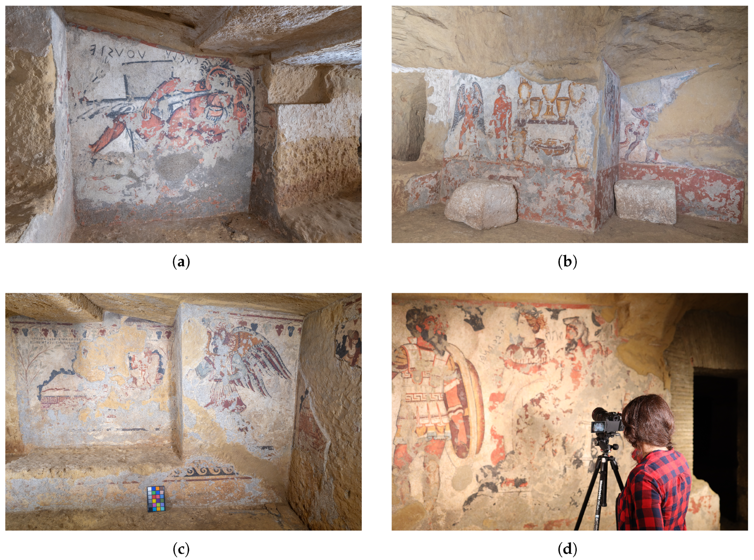
All photographs were taken using a tripod and a remote shutter release to ensure maximum stability and image sharpness. The depth of field was optimised by selecting an aperture between f/8 and f/16, ensuring uniform sharpness across the entire scene. Sequence planning was important: we first established a baseline sweep along the corridors axis, then circled pillars to capture all faces with consistent incident angles, and then filled occluded areas, and lastly we captured the ceilings (Figure 4).
3.
Light painting:
Inside the Etruscan tomb, uneven illumination was the main obstacle. The space is highly articulated, narrow corridors, central pillars, and static LED panels produced hard cast shadows and strong fall-off. Adding more lamps did not solve the problem in tight passages. Similar conditions and solutions are reported in the literature, where teams alternate between flashlights in extremely narrow spaces and light-painting for totally dark environments; multi-flash arrays are discussed but often deemed impractical when space and operators are limited [15]. Other colleagues also note vignetting and hotspot issues with on-camera or speedlight solutions, favoring light-painting to obtain uniform illumination for SfM [34]. More recently, “Chiaroscuro Photogrammetry” systematizes long-exposure imaging with a small, handheld LED moved across the scene, so that illumination is averaged over time while preserving the local contrast typical of a point source. This approach has documented advantages over flash, improving surface continuity and texture legibility [14].
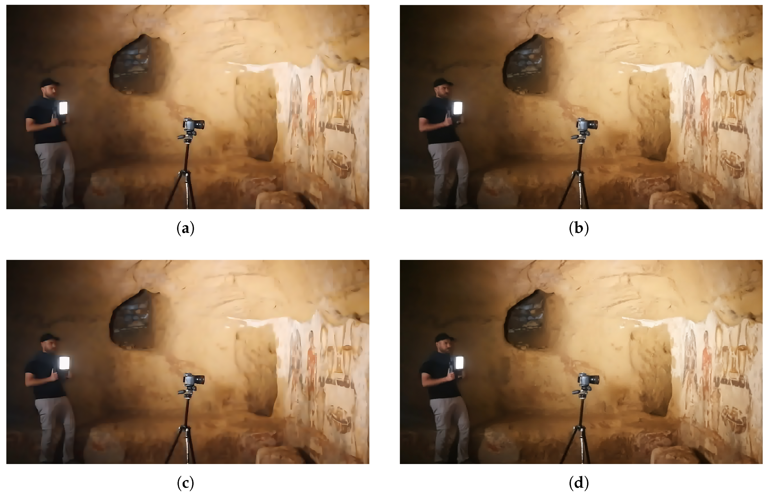
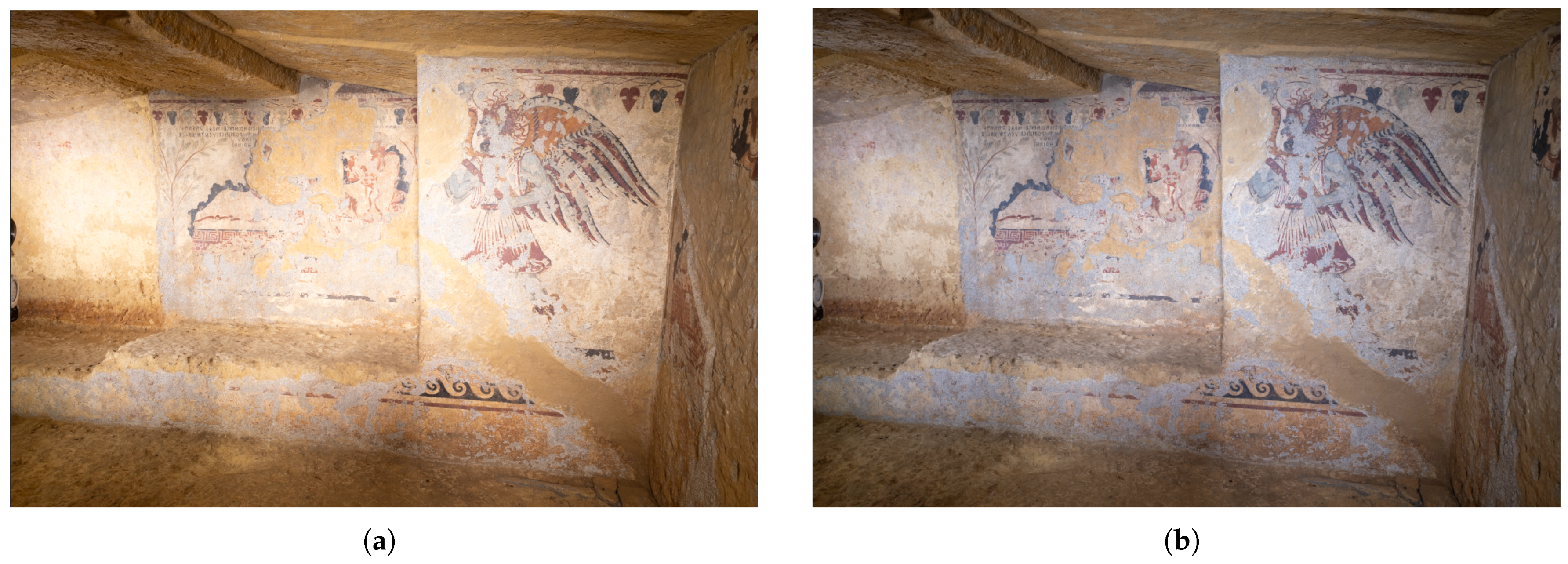
In our case, we faced the same spatial and logistical constraints noted by these authors and therefore avoided flash systems altogether. We adopted a light-painting strategy consistent with this body of work. Light painting is a long-exposure photographic technique in which a light source is moved through the scene during the exposure [35]. The adopted workflow was the following: the camera was mounted on a tripod and operated in full manual mode with constant parameters for SfM (ISO 100–200, aperture f/8–f/16, multi-second exposures), fixed white balance and remote triggering. For each image, an operator slowly “painted” the scene with one or two handheld LED lights, sweeping across walls, ceiling, floor, and around pillars (Figure 5); the continuous motion averaged light directionality, reducing cast shadows and fall-off while minimizing flare and hotspots. We maintained 70–80% overlap along corridors and around pillars, added obliques to strengthen geometry, placed coded targets where permitted, and verified histograms on site to avoid clipping. This workflow, inspired by above-mentioned practices, produced images with uniform illumination and textures well suited to tie-point extraction and dense matching in these confined, complex interiors (Figure 6).

2.2.2. Processing

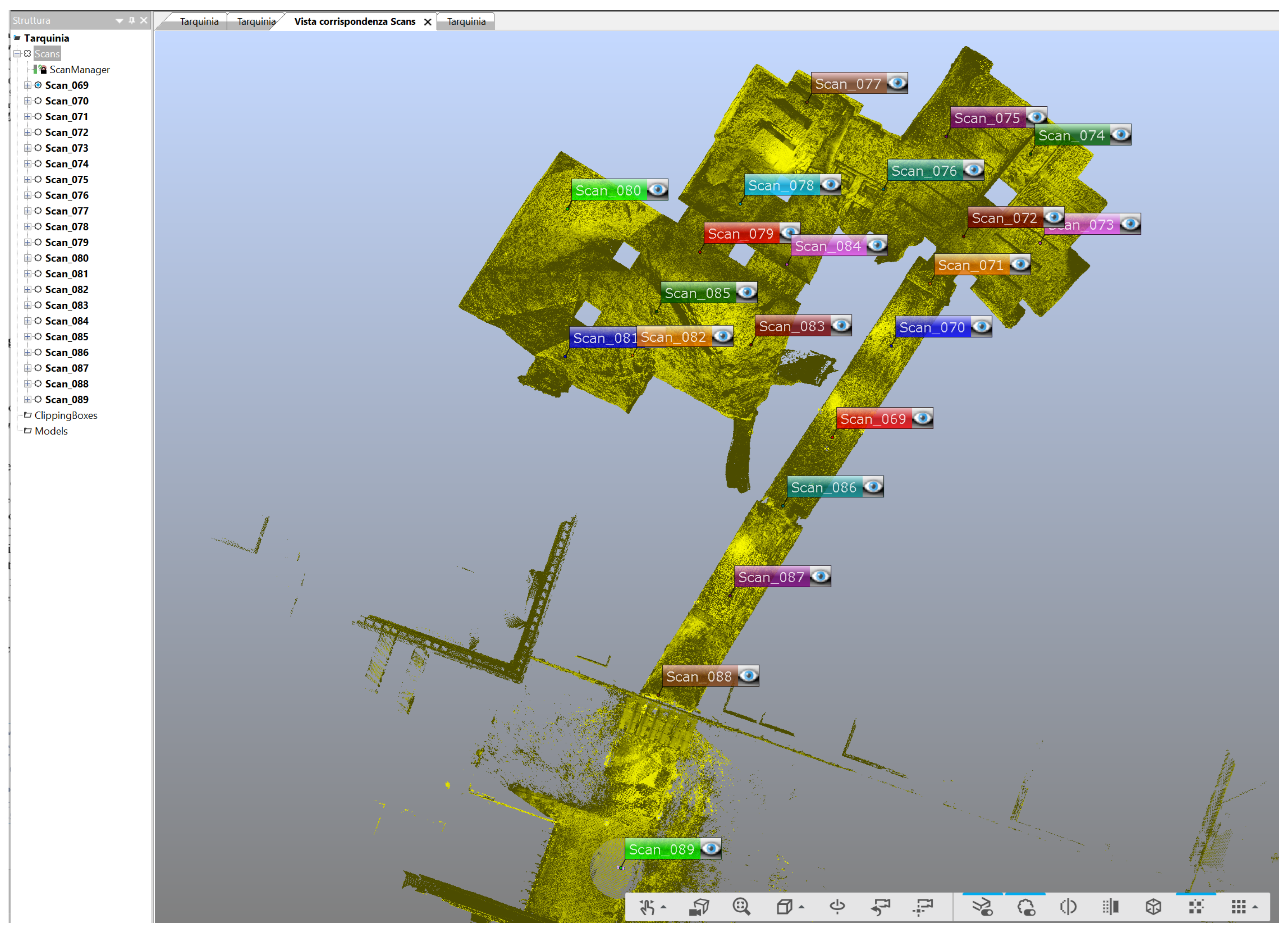
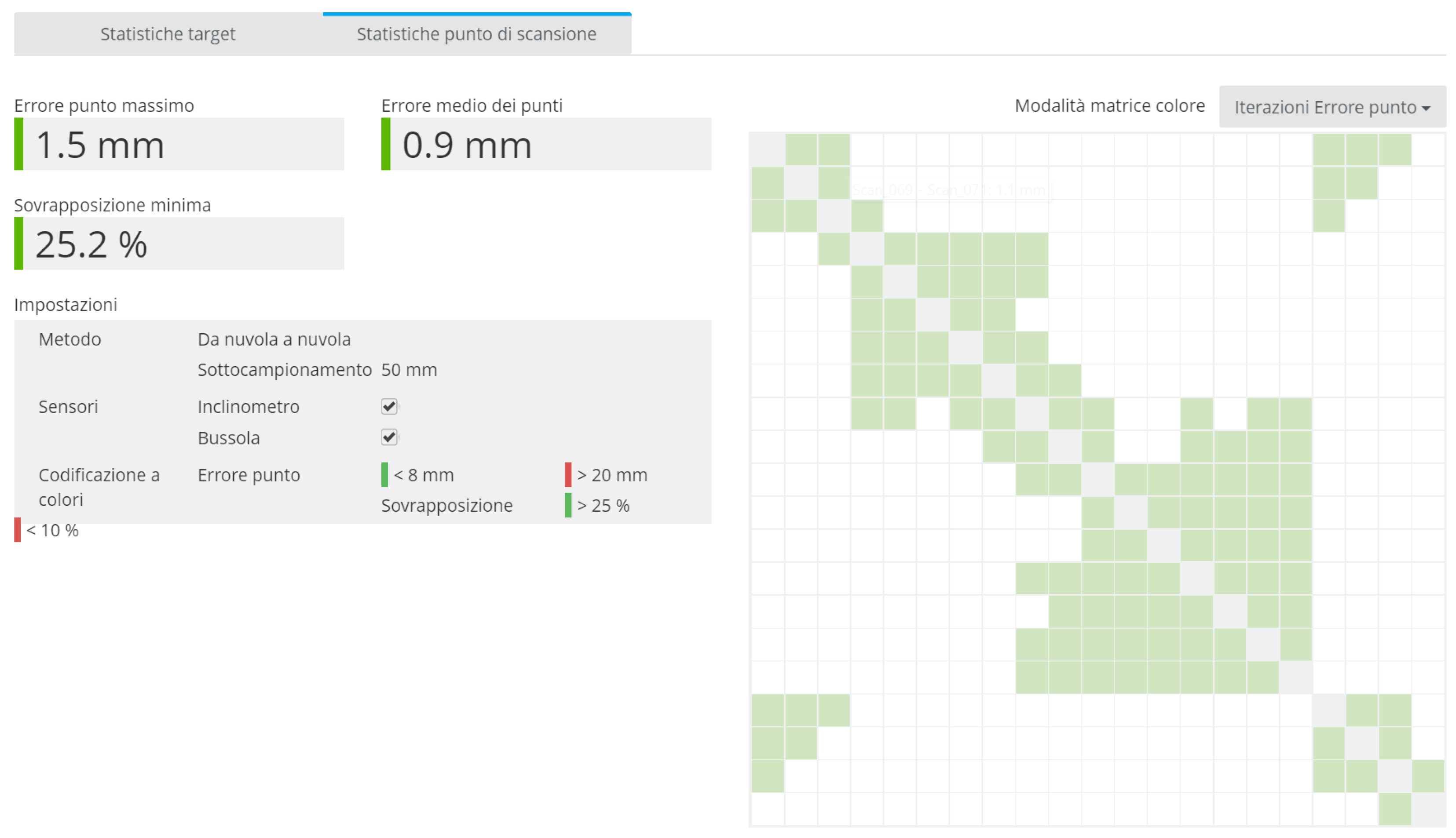
Using Faro Scene® software (v.2024.2), the scans were registered through automated alignment processes based on both the spherical targets and point cloud overlap (Figure 7). The average Root Mean Square (RMS) error, calculated following integration with topographic measurements, was found to be below 1 cm. This error serves as a quantitative indicator of the reliability of the scan registration and ensures the accuracy of the reconstructed 3D dataset (Figure 8).
The survey generated a structured point cloud consisting of approximately 84 million points. This was subsequently exported in .e57 format to guarantee broad compatibility with all 3D software for processing and integration. This means that the points are organised in such a way as to maintain the original spatial and geometric relationship of the data, while also including additional information such as intensity, colour and metadata. This information is useful for precise processing and efficient registration. The .e57 format, in particular, maintains: coordinates (x, y, z), intensity of the laser return, RGB colour associated with the points, Camera equirectangularity, Position and orientation of each individual scanner scan, and Metadata about the scanner.
Before photogrammetric data can be processed, a pre-processing phase must be performed on the RAW images using photographic editing software. In our case, photographs were processed in Adobe Lightroom v.14 to correct the white balance, tonal values, chromatic aberrations and contrast in the highlights and shadows. This step enables exposure, sharpness, highlights, shadows and white balance to be corrected. In our case, this stage was particularly important for removing the yellowish tint caused by the artificial lighting in the tomb. Accurate colour balancing was crucial to ensure a faithful representation of the textures (Figure 9). Once corrected, the images were exported in JPEG format for subsequent processing.
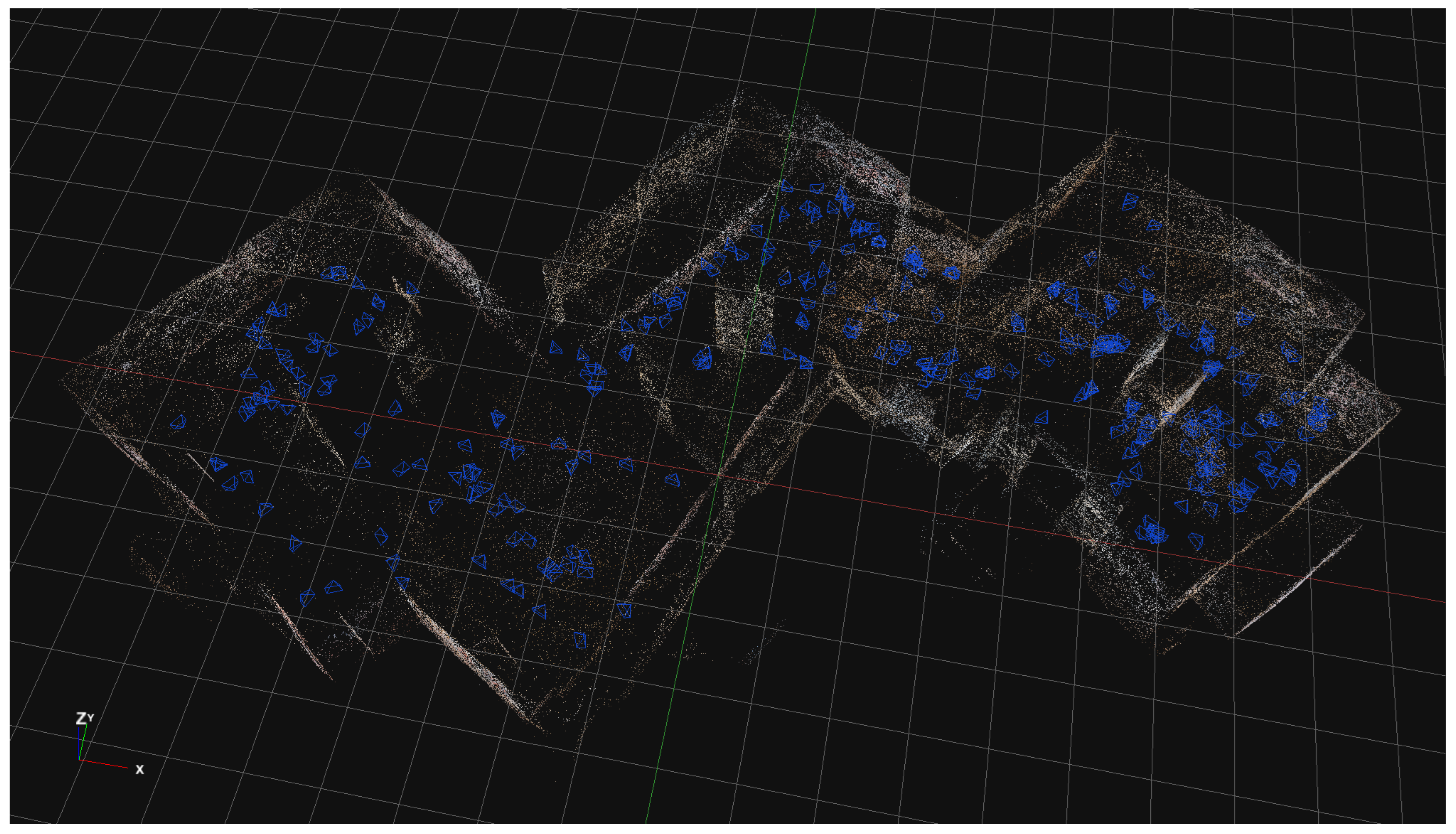
The photogrammetric processing itself was carried out using 3DF Zephyr (v.7.507), following a standard Structure from Motion (SfM) workflow [36]. The initial step involved the identification of key points and tie points within the image dataset, enabling the software to calculate the relative positions and orientations of the cameras. This preliminary alignment yielded a sparse point cloud, which produced a low-density representation of the object’s geometry (Figure 10). Subsequently, a dense point cloud was generated using dense stereo matching algorithms, which construct depth maps representing the distance of each pixel from the camera. This high-resolution point cloud, characterised by its detailed spatial accuracy, formed the basis for the generation of a triangular mesh. In the present project, the photogrammetric workflow was employed in order to produce high-quality textures, which were then projected onto the geometric model obtained from laser scanning. This integration leverages the metric accuracy of the scan and the superior image resolution and color management of photogrammetry—yielding a model well suited for robust documentation and digital dissemination

2.2.3. Integration

The integration of the laser scanner and photogrammetric data was performed in the 3DF Zephyr software, following a structured process:
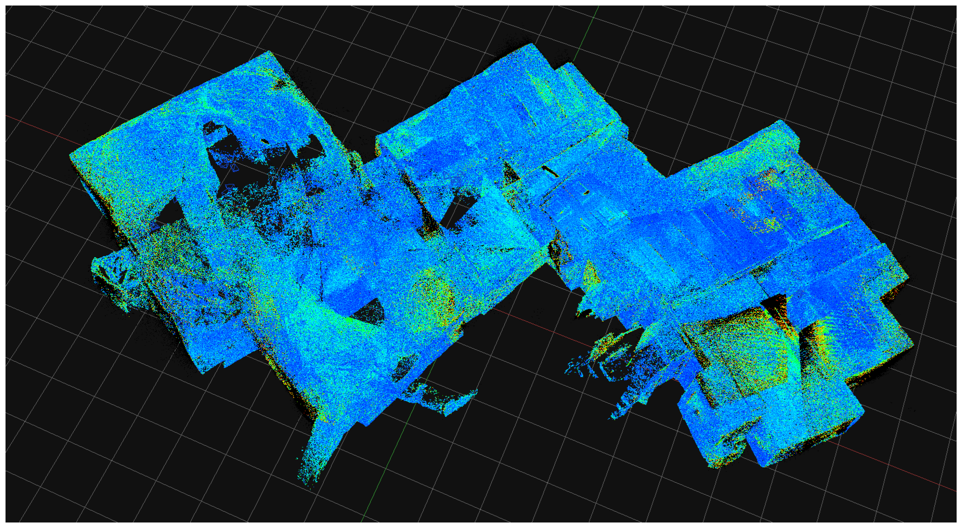
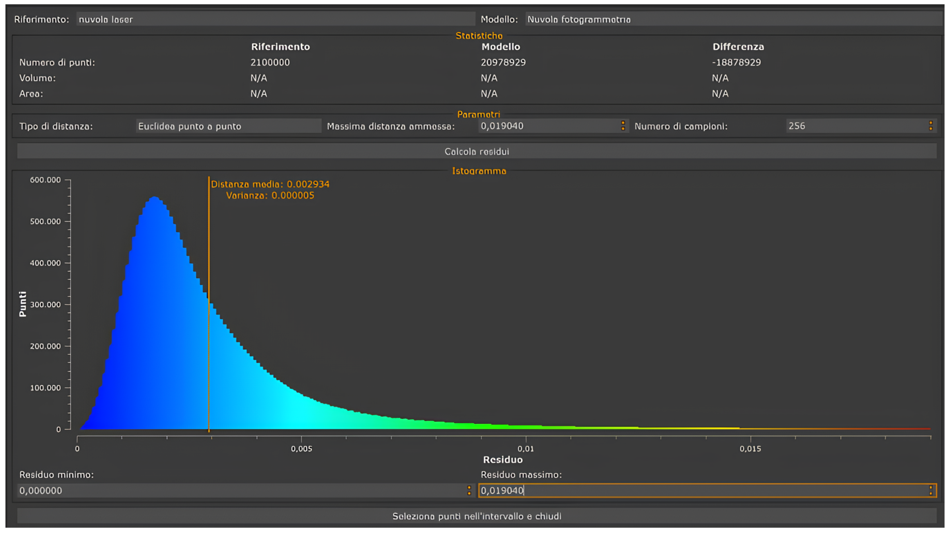
The integration was performed in 3DF Zephyr using two separate workspaces: Project 1 (laser scanning), containing the structured E57 and used as the reference, and Project 2 (photogrammetry), containing the oriented images and derived point clouds/mesh. The photogrammetric workspace was imported into the laser project, and a coarse co-registration was obtained by marking homologous control points visible in both datasets. The alignment was then refined with ICP tool, keeping the laser dataset fixed (reference) and moving the photogrammetric component (with its camera poses), enabling scaling. This procedure minimised residual distances and optimised the overlap; as shown in Figure 11 and Figure 12, the mean residual is 0.002 m (≈2 mm).
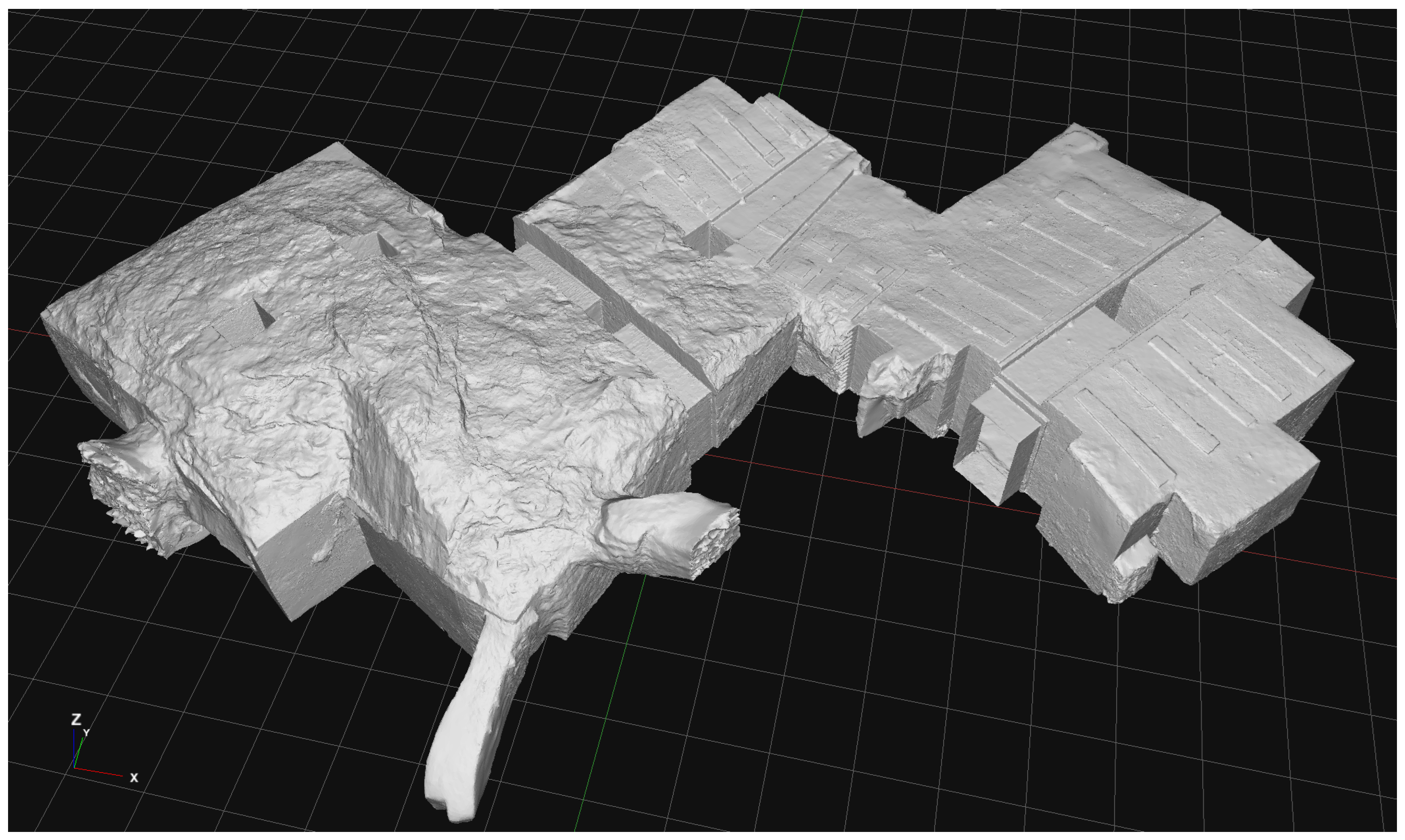
The generation of the 3D model is the first step in the process. The laser scanner cloud was triangulated to create a high-density polygonal mesh (46 million triangles).
In this context, texture denotes a two-dimensional image mapped onto a three-dimensional surface to convey colour and tonal detail. Textures were generated exclusively from the aligned photogrammetric images, which provide consistent, high-resolution inputs for colour mapping. We adopted a target texel density of 1 texel/mm (1000 px/m). Texel Density is a metric that represents the resolution of a texture relative to the size of a 3D object and is directly influenced by the GSD of the images used to create the texture. Specifically, it measures how many “texels” (individual texture units) are applied per unit of the object’s surface area. With a model surface area of 484.357 m2, this setup yields approximately 4.84 × 10⁸ required texels. Using 4K atlases (40962≈2 1.68 × 10⁷ texels each), this corresponds to ≈29 texture sheets; we rounded to 30 atlases to provide layout flexibility during UV unwrapping.
Local geometric gaps were filled in Zephyr (e.g., Mesh Filter → Fill Holes—Selective). Larger corrections were carried out in Blender 5.2, and the edited mesh was re-imported into Zephyr. Because those topological edits (hole filling, remeshing, decimation) invalidated existing UVs and texture projections, we re-projected the textures in the photogrammetry software to restore consistency. In areas with limited coverage (e.g., the backs of pillars and occluded floor/ceiling zones), residual artefacts were reduced through 3D texture painting in Blender. Minor retouching on exported maps was performed in 2D editors (GIMP v. 3.0.1), with colour management preserved and seams avoided.
The integration of surveying techniques enabled the combination of high geometric precision (laser scanning) with photorealistic visual detail (photogrammetry), thereby offering an immersive and accurate experience of the tomb model.

2.2.4. Optimization and Texture Re-Projection

To create a model suitable for publication on a web application, an optimization phase was required to reduce the model’s geometric complexity without compromising its level of detail and visual quality. Achieving this result may involve performing a remeshing of the asset, which can be done manually or automatically, depending on the requirements. For automatic remeshing, one of the most commonly used software tools is Instant Meshes (v.10.2), which converts a triangular mesh into a quad-dominant one. In some cases, tools within Blender, such as Decimate, can be used to reduce the number of polygons in the asset while preserving its geometry. In our case, the model was reduced to 1 million triangles as a good balanced solution that ensured a high standard of geometric detail, while granting a smooth web-based experience (Figure 13). Remeshing always requires the creation of a new texture, which involves generating a new UV map for the model and re-projecting the texture using photogrammetry software or performing a bake in Blender. A precise UV map enables adjustments to the Texel Density, allowing for increased resolution in areas of the model that demand higher visual detail (Figure 14).

2.2.5. Export and Presentation

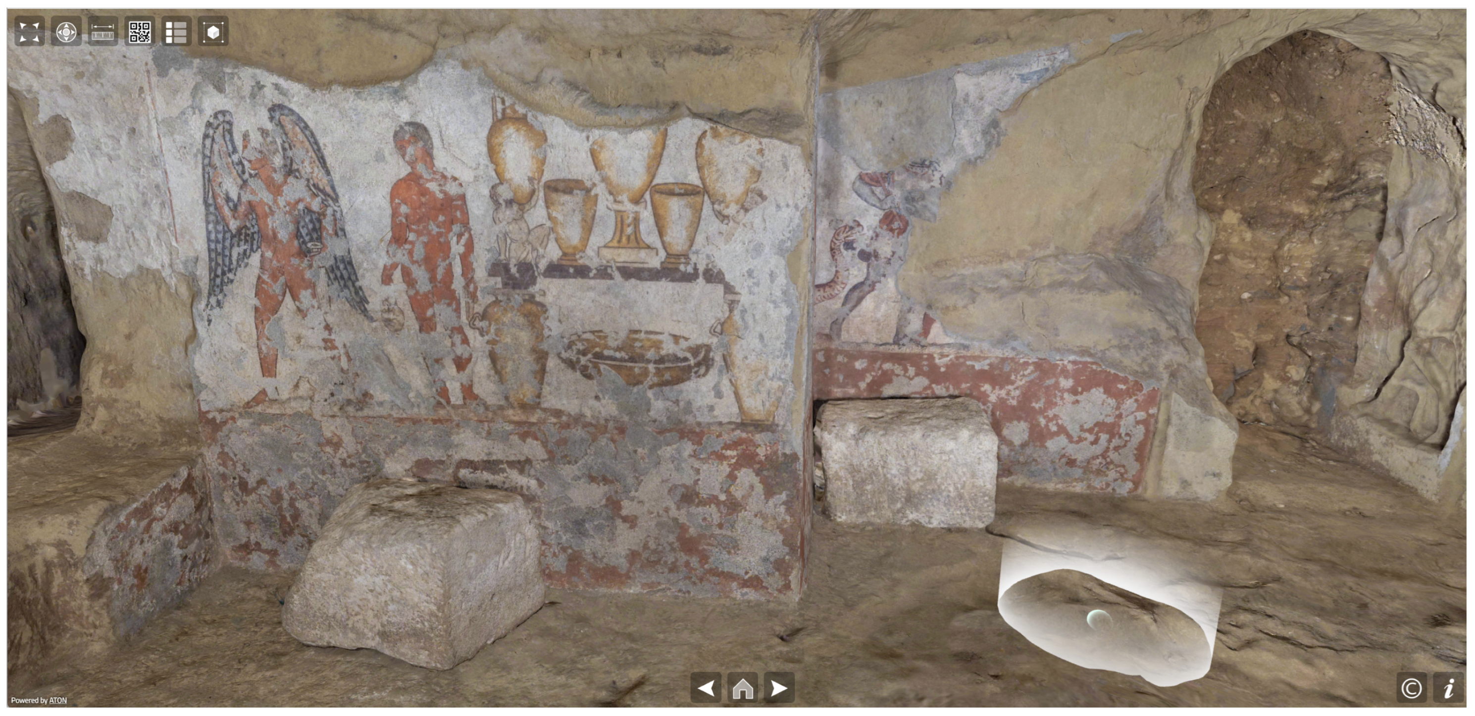
The final part of the workflow involves exporting the model into a format compatible with Web 3D applications such as ATON (https://osiris.itabc.cnr.it/aton/, accessed on 10 June 2025), ensuring it includes all the necessary information for its visualization (e.g., textures, other PBR materials, etc.). The chosen format is glTF, a standard format that facilitates the efficient transmission and rendering of 3D models, making it ideal for real-time visualization in Web3D applications. The export phase relies on a set of guidelines specifically designed for Web3D platforms (https://osiris.itabc.cnr.it/aton/index.php/tutorials/creating-3d-content-for-aton/exporting-3d-models-from-blender/, accessed on 10 June 2025). These guidelines were created to ensure compatibility and optimize performance within the target application, focusing on aspects such as geometry optimization, material configurations, and texture mapping. By adhering to these standards, it was possible to improve the usability and accessibility of the 3D model in a web-based context, in this case ATON (Figure 15).
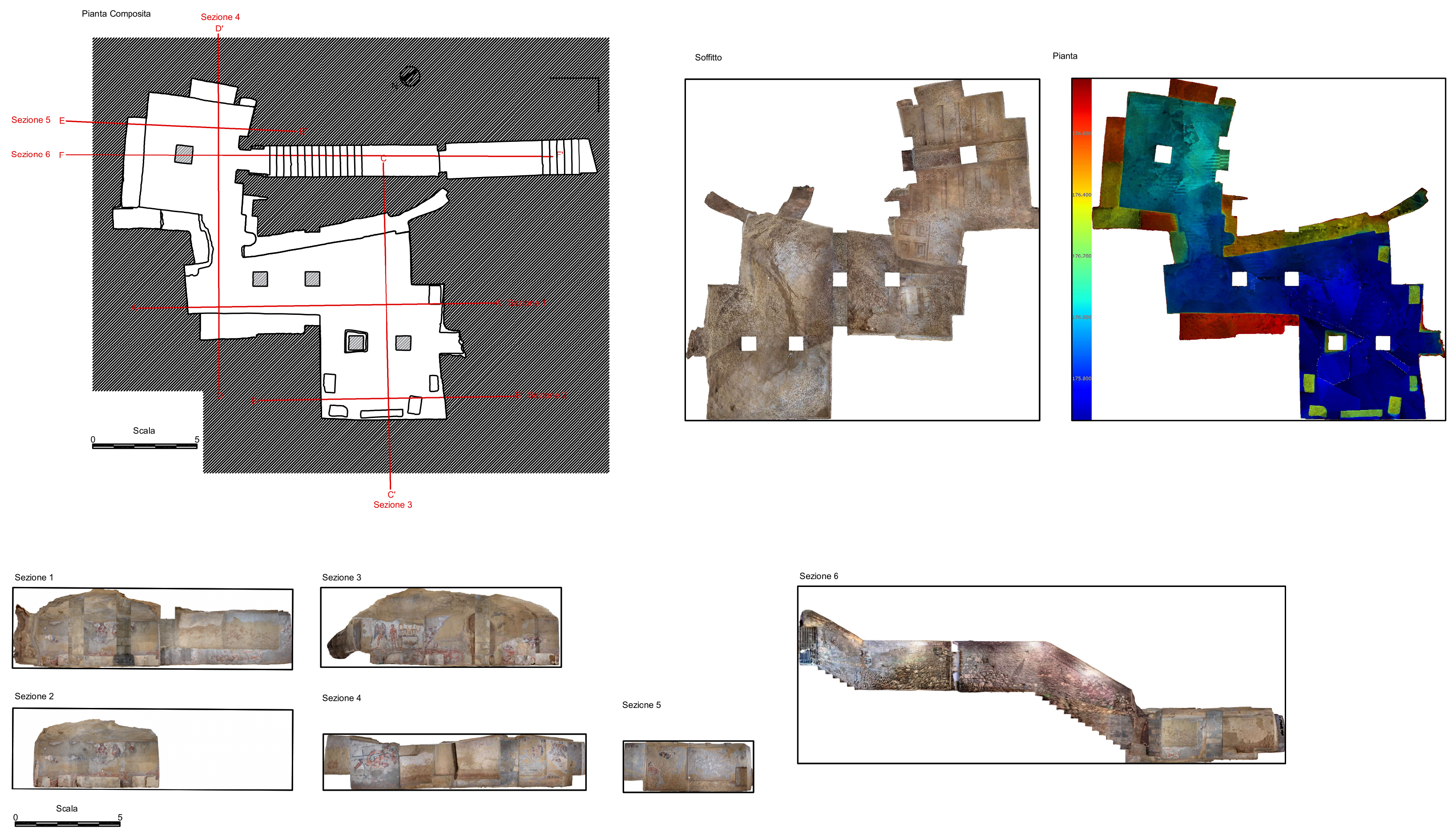
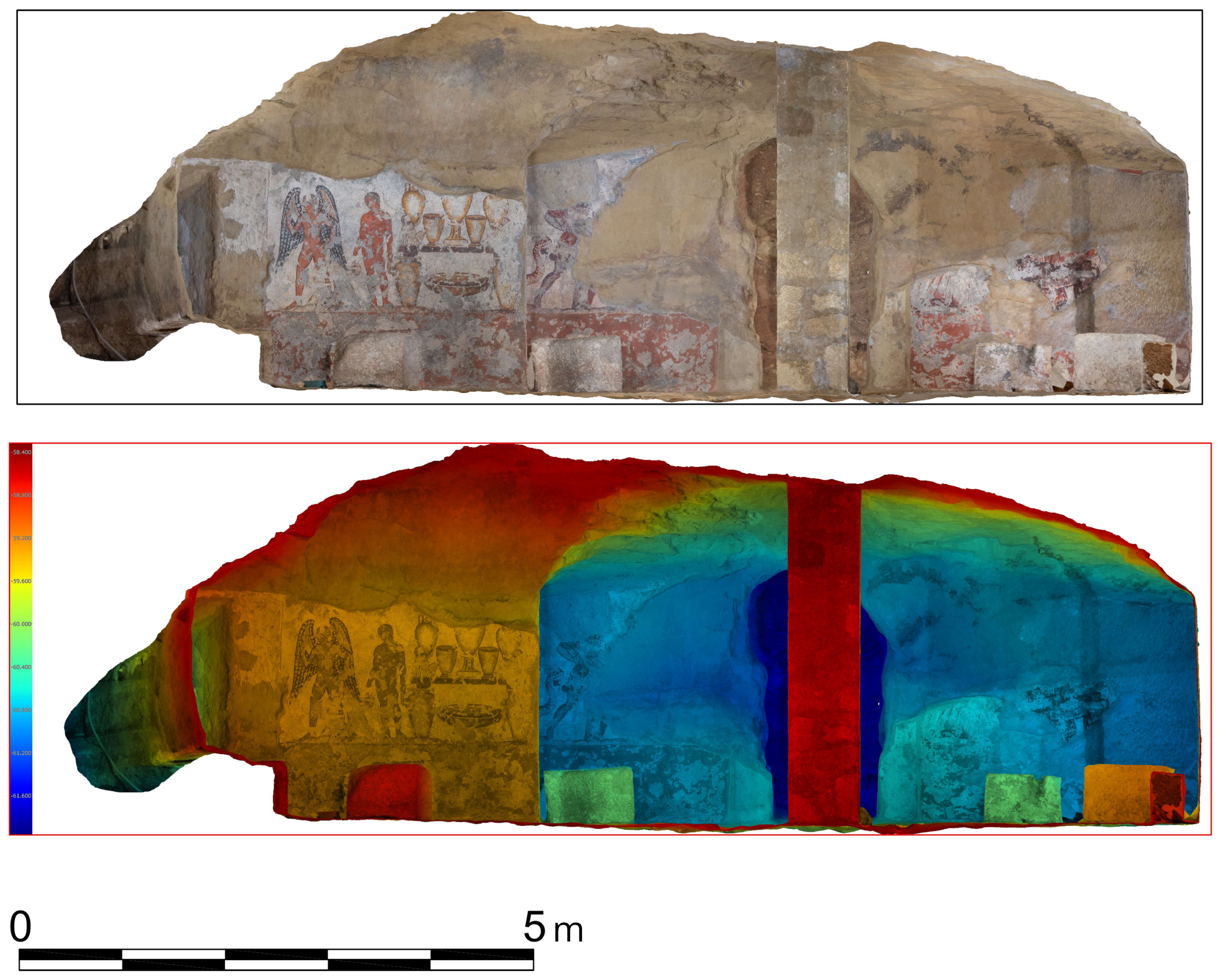
The integration of surveying techniques enabled the combination of high geometric precision (laser scanning) with photorealistic visual detail (photogrammetry), thereby offering an immersive and accurate experience of the tomb model. Furthermore, it also enables the extraction of highly accurate 2D outputs, useful for the planning of technical interventions by various professionals, such as high resolution orthomosaics, DSMs, sections and composite plans (Figure 16 and Figure 17).

3. Results

The integrated 3D survey of the Tomba dell’Orco enabled detailed documentation of the archaeological structure. Through the use of dynamic artificial lighting techniques, such as light painting, it was also possible to capture clear and well-lit images of the tomb’s interior. This approach allowed for the acquisition and processing, via a Structure from Motion (SfM) algorithm, of high-resolution textures of the painted decorations that adorn the inner walls of the tomb. The final result, following post-processing operations, is a 3D model with high-definition textures and geometric detail. The 3D model has been uploaded online to the ATON platform.
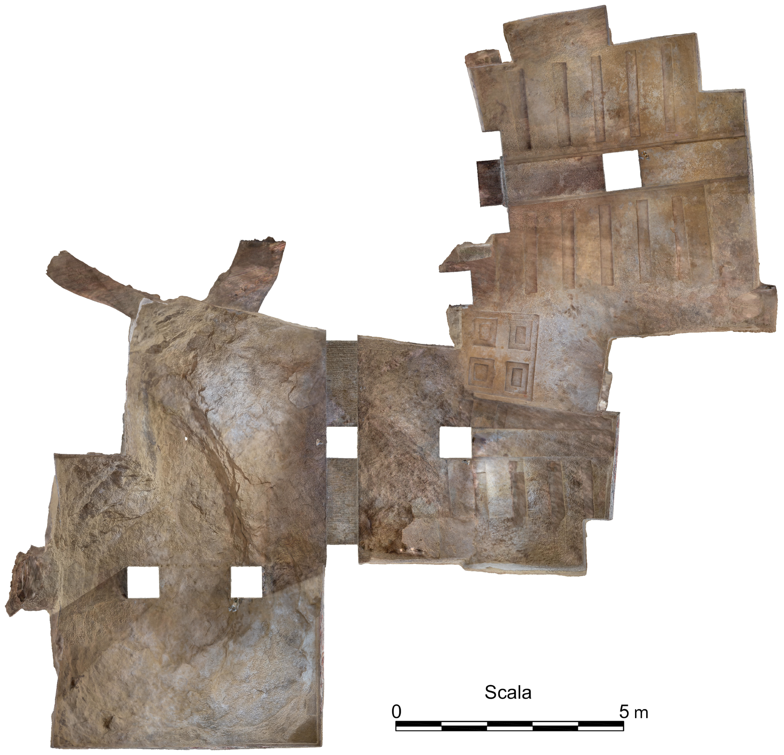
The resulting model was also employed to generate subsequent products, such as sections and plan views. These were utilised to illustrate the interior of the various rooms and to generate derived two-dimensional products, including orthographic sections of the various painted walls. The various sections were exported by the 3DF Zephyr software in JPEG format with a ground sample distance (resolution) of 1 mm/pixel, while the orthomosaics of the ceiling and floor have a resolution of 1.5 mm/pixel (Figure 18). All images were accompanied by AutoCAD .src scripts, which are essential for the proper import and automatic scaling of images in the Autodesk AutoCAD 2025 vector drawing software.
The model is currently available online for interactive navigation at this link: https://aton.ispc.cnr.it/s/dferdani/20241129-qppt04bvo (accessed on 20 October 2025).

4. Discussion

The topic of 3D documentation of cultural heritage has undoubtedly been riding a wave of interest for several years. Despite the significant technical and instrumental potential now available, there remains a structural limitation in terms of actual impact and outcomes. High-resolution 3D documentation of heritage assets often ends up being a secondary activity, insufficiently integrated into the core workflows related to the management, conservation, and enhancement of the heritage structure. Too often, field survey activities are disconnected from the actual potential offered by the 3D data. The result is a proliferation of partially complete 3D models, outcomes of surveys designed with a single objective in mind, which therefore struggle to generate real impact. In contrast, surveying complex structures like the Tomba dell’Orco encourages a broader reflection on the potential impact that a well-structured survey could actually achieve. In this specific case, the survey led to the creation of a multifunctional 3D model. This model serves as a valuable tool for analysing the current state of the tomb, supporting the targeted planning of restoration interventions that the responsible authorities have scheduled in view of the site’s reopening. The structure is not easily accessible, and clearly, the 3D model helps to address this issue by enabling measurements, simulations, and analyses directly on the digital replica. The accessibility issue, especially prior to restoration, also applies to the general public. The tomb has been closed, and will remain so, for an extended period. The high texture detail achieved through the combination of model optimisation and ATON’s ability to handle heavy 3D datasets allows for a fully photorealistic experience. Physical and virtual should not be seen as competing realities, but rather, they are like the warp and weft of the same fabric: only by intertwining them do they give shape and strength to the structure. While in this case the two modes of access (physical and virtual) may alternate, they offer valuable insight into future mixed-access strategies that could involve the broader necropolis area. Another relevant aspect is the monitoring of the tomb’s interior, especially regarding the preservation of the wall paintings. As of now, no sensors have been installed to monitor humidity and temperature within the structure. However, ATON allows for direct integration between the 3D model and in situ sensor systems, enabling live monitoring of the structure via mobile or wifi internet connection. This possibility represents a feasible and foreseeable development. This further expands the potential of the discussion, broadening it to the topic of the interdisciplinary impact made possible by accessible 3D data. In this specific case, the high-resolution model hosted on ATON enables, through built-in platform tools like semantic annotations, collaboration among professionals from different fields as well as virtual access for the public. In the current transitional phase, in what could be defined for the CH sector as the post-Sketchfab scenario, there is still no dominant platform in terms of widespread adoption [37]. However, ATON represents a very competitive solution: scalable, customisable, and open source. From a methodological perspective, this paper addresses the challenge of managing artificial lighting in underground environments, with the goal of optimising photogrammetric acquisition. Despite not being a standard acquisition choice, light painting has proven to be effective in practice by delivering more uniform lighting and higher texture fidelity. These gains were essential to produce photorealistic texture maps that meet both the documentation requirements of painted surfaces and the demands of immersive, real-time exploration on VR/Web3D platforms. Moreover, it accelerated the acquisition process by reducing the time required to constantly reconfigure artificial lighting setups. Additionally, it resulted in a visible improvement in the lighting conditions of certain parts of the tomb, such as the inner ceiling, that would have otherwise been difficult to document.
Beyond these qualitative observations, the integrated workflow offered notable operational and perceptual advantages. Dynamic lighting helped reduce cast shadows and illumination gradients that typically affect underground photography, producing more uniform and visually coherent textures. These characteristics are beneficial not only for documentation but also for real-time rendering, where consistent lighting across large surfaces is essential for immersive VR/XR experiences. Several limitations should also be acknowledged. Light painting depends partly on the operator’s movement, which may affect replicability, and long exposures can be problematic in environments subject to vibration or intermittent access. The scalability of the method to larger or more complex hypogea remains untested, and producing seamless textures across multiple atlases still requires time-consuming UV management. A controlled comparison between dynamic and static lighting is therefore a relevant direction for future research. Preliminary internal assessments—consistent with observations reported in our previous works, although not derived from controlled experiments—provide an initial indication of the workflow’s impact:
  • Illumination uniformity: estimated 70–80% reduction in cast shadows and lighting discontinuities.
  • Acquisition efficiency: 25–30% reduction in time spent repositioning lighting equipment.
  • Texture coherence on curved surfaces: perceived 30–40% improvement in chromatic continuity on concave or irregular areas.
  • Post-processing efficiency: 30–40% reduction in time needed for masking, shadow correction, and colour balancing.
Although indicative, these values offer a preliminary quantitative framework for understanding the benefits of dynamic lighting and point to the need for further studies under controlled conditions.

5. Conclusions

The starting point of the research was to create a comprehensive three-dimensional documentation aimed at promoting access, knowledge dissemination, and the cultural valorisation of the wall paintings through the high-resolution 3D model of the interior chambers of the Tomba dell’Orco. Building on this foundation, the analysis of the challenges encountered during the survey of the tomb complex prompted an expansion of the investigative scope. Four main research questions were identified concerning whether and how acquisition processes could be enhanced in underground, poorly illuminated heritage sites.
First of all, the integration of terrestrial laser scanning (TLS) and photogrammetry has proven to be the most effective approach for achieving accurate geometric data and photorealistic visual detail. The innovative aspect of this work lies in the integration of light painting with standard static-light photogrammetry, a combination that, in a similar context, had not previously been tested. This technique, based on the dynamic use of artificial light during the acquisition phase, was applied alongside static-light acquisitions conducted in nearly all environments, significantly improving lighting uniformity in areas that are typically more difficult to document, such as ceilings and niches.
The second research question builds directly upon the first. The combined use of photogrammetry and light painting has proven particularly effective for documenting the conservation state of wall paintings, even in challenging environmental conditions such as high humidity and low illumination. It is evident that the choice of instruments and techniques is closely tied to the characteristics of the subject being recorded. In the case of heritage assets, where geometric and visual characteristics must be properly addressed, integrated surveying remains the most reliable option, although slower and more delicate to implement. This is particularly evident in hypogean structures, such as the case study presented here, where lighting conditions represent one of the major risk factors. In our case, carefully selecting the appropriate technique for each section of the tomb not only accelerated acquisition times but also minimised shadows and chromatic distortions, ensuring a more accurate and conservation-oriented visual representation. This represents a key step in 3D heritage documentation workflows, especially for a specific category of artefacts that are often difficult to document accurately.
In relation to the third research question, the present study has demonstrated how an integrated approach—grounded in advanced digital documentation techniques, remote sensing systems, and virtual accessibility solutions—can contribute concretely to both the preservation and valorisation of the tomb. The resulting high-definition 3D model, with detailed geometric and visual accuracy, enables metric analyses, simulations, and monitoring in preparation for future restoration interventions. This approach is particularly advantageous for enclosed or fragile environments, such as the Tomba dell’Orco, where physical access may endanger the microclimatic balance essential to the preservation of mural paintings.
Finally, in addressing the fourth research question, the use of 3D web applications for the final presentation of the reconstructed tomb model appears to be an effective way to enhance the visibility and accessibility of an otherwise inaccessible monument, thereby supporting both its preservation and promotion. The high-resolution 3D model will be made available to the public through ATON, directly from inside the museum, allowing the underground chambers to be explored digitally during the planned restoration activities. Within the Tarquinia Museum, it will form part of the multimedia installations in the Hall of the Painted Tombs, offering an immersive virtual tour, via headset, that illustrates the journey to the Underworld and presents the mythological figures depicted on the tomb’s walls. On the occasion of the forthcoming exhibition on Etruscan painting in Tarquinia, the model will also be used to establish a parallel with the Golini I Tomb of Orvieto, enabling visitors to explore shared iconographies and recurring themes. In this context, the visual quality achieved through dynamic lighting plays a particularly important role. Light painting produced textures characterised by diffuse illumination and minimal cast shadows, resulting in a visually coherent and aesthetically faithful representation of the tomb. This uniformity is especially beneficial in real-time web3D environments such as ATON, where immersive VR/XR exploration requires consistent lighting across large surfaces. Moreover, because the baked textures do not include strong directional shadows, the virtual model can be illuminated dynamically in real time—allowing users to change lighting conditions during exploration without perceiving inconsistencies between real-time shading and the original photographic textures. This compatibility between baked and dynamic lighting contributes to enhancing realism, immersion, and perceptual coherence within the virtual experience.

Author Contributions

Conceptualization, M.L., M.F.R., D.F. and M.C.T.; methodology, M.L., M.F.R. and D.F.; validation, M.L., M.F.R. and D.F.; formal analysis, M.L., M.F.R. and D.F.; investigation, M.L., M.F.R. and D.F.; data curation, M.L., M.F.R. and D.F.; writing—original draft preparation, M.L., M.F.R.; writing Case study V.B., R.F., M.C.T.; writing—review and editing, M.L., M.F.R. and D.F.; visualization, M.L., M.F.R. and D.F.; supervision, D.F.; project administration, D.F., V.B., R.F., M.C.T.; funding acquisition, V.B., R.F., M.C.T. All authors have read and agreed to the published version of the manuscript.

Funding

The support of MUR (FOE E-RIHS IT and PON Ricerca e Innovazione 2014-2020, CCI: 2014IT16M2OP005) is acknowledged.

Institutional Review Board Statement

Not applicable.

Informed Consent Statement

Not applicable.

Data Availability Statement

The 3D model of the Tomba dell’Orco is publicly available online for interactive navigation at https://aton.ispc.cnr.it/s/dferdani/20241129-qppt04bvo (accessed on 20 October 2025).

Acknowledgments

The authors would like to express their sincere gratitude to B. Fanini for his support with the model optimisation and with the ATON platform. AI-based software tools were used for language review and grammar checks to enhance readability of the manuscript. These tools were applied exclusively for editing purposes to ensure the quality of the English language without affecting the scientific content of the work.

Conflicts of Interest

Author Riccardo Frontoni was employed by the company Ales—Arte Lavoro e Servizi S.p.A. The remaining authors declare that the research was conducted in the absence of any commercial or financial relationships that could be construed as a potential conflict of interest.

References

  1. Calicchia, P.; Ceccarelli, S.; Colao, F.; D’Erme, C.; Di Tullio, V.; Guarneri, M.; Luvidi, L.; Proietti, N.; Spizzichino, V.; Zampelli, M.; et al. Multi-Technique Approach for the Sustainable Characterisation and the Digital Documentation of Painted Surfaces in the Hypogeum Environment of the Priscilla Catacombs in Rome. Sustainability 2024, 16, 8284. [Google Scholar] [CrossRef]
  2. Aricò, M.; La Guardia, M.; Lo Brutto, M. 3D Data Integration for Web Fruition of Underground Archaeological Sites: A Web Navigation System for the Hypogeum of Crispia salvia (Marsala, Italy). Heritage 2023, 6, 5899–5918. [Google Scholar] [CrossRef]
  3. Aricò, M.; La Guardia, M.; Lo Brutto, M. Web Exploration Of Cultural Heritage With Limited Accessibility: First Experimentation For Hypogeum Archaeological Sites. Int. Arch. Photogramm. Remote Sens. Spatial Inf. Sci. 2023, XLVIII-M-2-2023, 111–117. [Google Scholar] [CrossRef]
  4. Chiabrando, F.; Sammartano, G.; Spanò, A.; Spreafico, A. Hybrid 3D Models: When Geomatics Innovations Meet Extensive Built Heritage Complexes. ISPRS Int. J. Geo-Inf. 2019, 8, 124. [Google Scholar] [CrossRef]
  5. Alshawabkeh, Y.; Baik, A.; Miky, Y. Integration of Laser Scanner and Photogrammetry for Heritage BIM Enhancement. ISPRS Int. J. Geo-Inf. 2021, 10, 316. [Google Scholar] [CrossRef]
  6. Taccola, E.; Rosselli, L.; Albertini, N.; Martino, M. Etruscan hypogea in 3D: A proposal for an immersive and interactive visualization of Volterra’s funerary contexts. Archeol. Calc. 2021, 32, 135–152. [Google Scholar] [CrossRef]
  7. Muñoz-Muñoz, A.; Fernández-Sánchez, D.; Vijande-Vila, E.; Becerra-Martín, S.; Cantillo-Duarte, J.J.; Domínguez-Bella, S.; Martínez Enamorado, V.; Rengel Castro, F.; Cantalejo Duarte, P.; Espejo-Herrerías, M.D.M.; et al. Application of photogrammetry and laser scanner on the Bronze Age structures of the Castillejos de Luna cist tomb necropolis (Pizarra, Spain). Virtual Archaeol. Rev. 2023, 14, 26–44. [Google Scholar] [CrossRef]
  8. Ruiz, R.M.; Torres, M.T.M.; Allegue, P.S. Comparative Analysis Between the Main 3D Scanning Techniques: Photogrammetry, Terrestrial Laser Scanner, and Structured Light Scanner in Religious Imagery: The Case of The Holy Christ of the Blood. J. Comput. Cult. Herit. 2022, 15, 1–23. [Google Scholar] [CrossRef]
  9. Milosz, M.; Kęsik, J.; Montusiewicz, J. 3D Scanning and Visualization of Large Monuments of Timurid Architecture in Central Asia—A Methodical Approach. J. Comput. Cult. Herit. 2021, 14, 1–31. [Google Scholar] [CrossRef]
  10. Apollonio, F.I.; Apollonio, F.I.; Fantini, F.; Fantini, F.; Garagnani, S.; Garagnani, S.; Garagnani, S.; Gaiani, M.; Gaiani, M. A Photogrammetry-Based Workflow for the Accurate 3D Construction and Visualization of Museums Assets. Remote Sens. 2021, 13, 1–39. [Google Scholar] [CrossRef]
  11. Wong, L.; Rose, W.; Dhanda, A.; Flavin, A.; Barazzetti, L.; Ouimet, C.; Santana Quintero, M. Maximizing the Value of Photogrammetric Surveys in the Conservation of Wall Paintings. Int. Arch. Photogramm. Remote Sens. Spat. Inf. Sci. 2021, 46, 851–857. [Google Scholar] [CrossRef]
  12. Rose, W.; Barazzetti, L.; Corda, K.; Wong, L. Research and development of a photogrammetric condition monitoring workflow to improve change detection in wall paintings. Stud. Conserv. 2022, 67, 235–244. [Google Scholar] [CrossRef]
  13. Huang, Y.; Tsang, S.C.; Wong, H.T.T.; Lam, M.L. Computational light painting and kinetic photography. In Proceedings of the Joint Symposium on Computational Aesthetics and Sketch-Based Interfaces and Modeling and Non-Photorealistic Animation and Rendering, Victoria, BC, Canada, 17–19 August 2018; pp. 1–9. [Google Scholar] [CrossRef]
  14. Jalandoni, A.; Haubt, R.; Walshe, K.; Nowell, A. Chiaroscuro Photogrammetry: Revolutionizing 3D Modeling in Low Light Conditions for Archaeological Sites. J. Field Archaeol. 2025, 50, 132–144. [Google Scholar] [CrossRef]
  15. Rossi, C.; Fassi, F.; Achille, C. LIFE Project: Evolution of survey techniques along the border of the Roman Empire. In Proceedings of the IMEKO International Conference on Metrology for Archaeology and Cultural Heritage, Turin, Italy, 19–21 October 2016; pp. 95–99. [Google Scholar]
  16. Salamon, N.Z.; Lancelle, M.; Eisemann, E. Computational Light Painting Using a Virtual Exposure. Comput. Graph. Forum 2017, 36, 1–8. [Google Scholar] [CrossRef]
  17. Pope, F.D.; Price, R.; Woolley, K.E.; Luiu, C.; Alam, M.S.; Avis, W.R.; Bartington, S.E.; Debebe, D.; Getaneh, Z.; Greenfield, S.M.; et al. Light painting photography makes particulate matter air pollution visible. Commun. Earth Environ. 2024, 5, 294. [Google Scholar] [CrossRef]
  18. Fanini, B.; Ferdani, D.; Demetrescu, E.; Berto, S.; d’Annibale, E. ATON: An Open-Source Framework for Creating Immersive, Collaborative and Liquid Web-Apps for Cultural Heritage. Appl. Sci. 2021, 11, 11062. [Google Scholar] [CrossRef]
  19. Ferdani, D.; Ronchi, D.; Fanini, B.; Manganelli Del Fà, R.; d’Annibale, E.; Bordignon, A.; Pescarin, S. Brancacci Chapel In Florence: Surveying And Real-Time 3d Simulation For Conservation And Communication Purposes. Int. Arch. Photogramm. Remote Sens. Spatial Inf. Sci. 2023, XLVIII-M-2-2023, 535–540. [Google Scholar] [CrossRef]
  20. Helbig, W. Dipinti tarquiniesi. Ann. Inst. Corrisp. Archeol. 1870, 42, 5–74. [Google Scholar]
  21. Weber-Lehmann, C. Polyphem in der Unterwelt? Zur Tomba dell’Orco II in Tarquinia. In Mitteilungen des Deutschen Archäologischen Instituts, Römische Abteilung; Deutsches Archäologisches Institut: Berlin, Germany, 1995; Volume 102. [Google Scholar]
  22. D’Agostino, S.; Lombardi, G.; Russo, G.; Viggiani, C. Structural engineering and geology applied to the static problems of the Etruscan ”Tomba dell’Orco” (Tarquinia, Central Italy). J. Cult. Herit. 2010, 11, 107–112. [Google Scholar] [CrossRef]
  23. Torelli, M. Gli Spurinas: Una Famiglia di Principes Nella Tarquinia della “Rinascita”; “L’Erma” di Bretschneider: Rome, Italy, 2019. [Google Scholar]
  24. Torelli, M. Elogia Tarquiniensia; Sansoni: Firenze, Italy, 1975. [Google Scholar]
  25. Ortoleva, J.K. Sounds of Etruria: Aural characteristics of the Tomba dell’Orco, Tarquinia. Antiquity 2021, 95, 1179–1194. [Google Scholar] [CrossRef]
  26. Massa Pairault, F.H. La Tombe François et la vision politique de l’Étrurie au IVè siècle a. C. Ostraka Ostraka Riv. Antich. 2013, 22–23, 7–91. [Google Scholar]
  27. Harari, M. Orco III. Quad. ACME 2013, 134, 287–308. [Google Scholar]
  28. Morandi, M. Novità sui Velcha di Tarquinia. Archeol. Class. 1995, 47, 267–288. [Google Scholar]
  29. Maggiani, A. Simmetrie architettoniche, dissimmetrie rappresentative. Osservando le pitture della Tomba degli Scudi di Tarquinia. In Proceedings of the Ricerche in Corso tra Etruria e Campania, Atti della Giornata di Studio, Santa Maria Capua Vetere, Italy, 28 March 2003; Arte Tipografica Editrice: Napoli, Italy, 2005; pp. 115–143. [Google Scholar]
  30. Sodo, A.; Artioli, D.; Botti, A.; De Palma, G.; Giovagnoli, A.; Mariottini, M.; Paradisi, A.; Polidoro, C.; Ricci, M.A. The colours of Etruscan painting: A study on the Tomba dell’Orco in the necropolis of Tarquinia. J. Raman Spectrosc. 2008, 39, 1035–1041. [Google Scholar] [CrossRef]
  31. Tomassetti, M.C.; Bellelli, V.; Garzulino, A.; Marzullo, M.; Morezzi, E.; Vagnarelli, T. I nuovi Piani per la Conservazione Programmata del Parco archeologico di Cerveteri e Tarquinia: Aggiornamento dei sistemi di gestione per la conoscenza, la conservazione e la manutenzione dei monumenti e della vegetazione e per i rischi connessi al cambiamento climatico. In Proceedings of the Atti del Convegno «Conservazione Preventiva e Programmata. Verso un Protocollo Condiviso nei Luoghi della Cultura», Roma, Italy, 7–8 May 2025. Perugia, Italy, 9 May 2025 Under Publication. [Google Scholar]
  32. Barzaghi, S.; Bordignon, A.; Collina, F.; Fabbri, F.; Fanini, B.; Ferdani, D.; Gualandi, B.; Heibi, I.; Mariniello, N.; Massari, A.; et al. A reproducible workflow for the creation of digital twins in the cultural heritage domain. Transform. Dariah J. 2025, 1, 1–62. [Google Scholar] [CrossRef]
  33. Bordignon, A.; Barzaghi, S.; Collina, F.; Fabbri, F.; Fanini, B.; Ferdani, D.; Marinello, N.; Moretti, A.; Rega, M.F.; Sullini, M. Guidelines for the Digitisation of Museum and Art Collections: Guidelines for Digitisation of Collections’ Items: Guidelines for 360° Virtual Tours: Guidelines for Digitisation of Architecture-Scale Objects. 2024. Available online: https://zenodo.org/records/14249936 (accessed on 21 October 2025).
  34. Perfetti, L.; Fassi, F.; Rossi, C. Low-cost digital tools for archaeology. In Innovative Models for Sustainable Development in Emerging African Countries; Springer: Berlin/Heidelberg, Germany, 2020; p. 137. [Google Scholar]
  35. Bertrand, S.; Prevost, L.; Ionascu, F.; Briere, A.; Koskas, R.; Taquet, R.; Andrianantoandro, F.; Kanzari, M. Light painting with mobile robots as motivating projects for robotics and control education. In Proceedings of the International Conference on Robotics in Education (RiE), Online, 27–28 April 2022; Springer: Berlin/Heidelberg, Germany, 2022; pp. 27–38. [Google Scholar]
  36. Remondino, F. Heritage recording and 3D modeling with photogrammetry and 3D scanning. Remote Sens. 2011, 3, 1104–1138. [Google Scholar] [CrossRef]
  37. Papadopoulos, C.; Gillikin Schoueri, K.; Schreibman, S. And Now What? Three-Dimensional Scholarship and Infrastructures in the Post-Sketchfab Era. Heritage 2025, 8, 99. [Google Scholar] [CrossRef]
Figure 1. Geographical context of the tomb’s location (Base map: Open Street Map).
Applsci 15 12463 g001
Figure 2. Plan of the tomb updated after the 2025 3D recording campaign.
Applsci 15 12463 g002
Figure 4. (a) Detail of the tomb’s interior decoration. (b) Detail of the tomb’s interior decoration. (c) Detail of the acquisition phase with the colour checker. (d) Detail of the photo acquisition setup with camera and tripod.
Applsci 15 12463 g004
Figure 5. Detail of the light painting technique applied in the acquisition of the depicted decoration: from (ad) example of continuous motion of the handheld light.
Applsci 15 12463 g005
Figure 6. Example of data captured before and after the integration of light painting: (a) texture obtained from TLS equirectangular images acquired under static lighting; (b) texture obtained from camera images using light painting.
Applsci 15 12463 g006
Figure 7. TLS registered point cloud inside the software Scene.
Applsci 15 12463 g007
Figure 8. Report on point accuracy. Max. point error: 1.5 mm; Average points error: 0.9 mm; Minimal overlap: 25.2%.
Applsci 15 12463 g008
Figure 9. Example of image editing after the photogrammetric survey: (a) Before colour correction; (b) After colour correction.
Applsci 15 12463 g009
Figure 10. Sparse point cloud with camera positions (blue squares).
Applsci 15 12463 g010
Figure 11. Point cloud registration, colors are assigned as shown in the histogram in Figure 12.
Applsci 15 12463 g011
Figure 12. Point cloud report. Average distance: 0.002934; Variance: 0.000005; Max. residue: 0.019.
Applsci 15 12463 g012
Figure 13. 1-million-triangle decimated mesh.
Applsci 15 12463 g013
Figure 14. The texturised mesh.
Applsci 15 12463 g014
Figure 15. View of the 3D model on ATON.
Applsci 15 12463 g015
Figure 16. Plan with section views, ceiling and DSM.
Applsci 15 12463 g016
Figure 17. Detail of section 3: RGB and DSM orthoprojections.
Applsci 15 12463 g017
Figure 18. Orthomosaic of the tomb’s ceiling.
Applsci 15 12463 g018
Disclaimer/Publisher’s Note: The statements, opinions and data contained in all publications are solely those of the individual author(s) and contributor(s) and not of MDPI and/or the editor(s). MDPI and/or the editor(s) disclaim responsibility for any injury to people or property resulting from any ideas, methods, instructions or products referred to in the content.