Article

The Evolution Mechanism and Stability Prediction of the Wanshuitian Landslide, an Oblique-Dip Slope Wedge Landslide in the Three Gorges Reservoir Area

1
Faculty of Engineering, China University of Geosciences, Wuhan 430074, China
2
Badong National Observation and Research Station of Geohazards, China University of Geosciences, Wuhan 430074, China
3
School of Resources and Geosciences, China University of Mining and Technology, Xuzhou 221116, China
4
The Seventh Geological Brigade of Hubei Geological Bureau, Yichang 443000, China
*
Authors to whom correspondence should be addressed.
Appl. Sci. 2025, 15(16), 9194; https://doi.org/10.3390/app15169194 (registering DOI)
Submission received: 20 July 2025 / Revised: 15 August 2025 / Accepted: 19 August 2025 / Published: 21 August 2025
(This article belongs to the Section Earth Sciences)

Abstract

The Zigui Basin, located in the Three Gorges Reservoir Area, has developed numerous landslides due to its interlayering of sandstone and mudstone, geological structure, and reservoir operations. This study identifies a fourth type of landslide failure mode: an oblique-dip slope wedge (OdSW) landslide, based on the Wanshuitian landslide. Following four heavy rainfall events from 3 to 13 July 2024, this landslide exhibited significant deformation on the 17th and was completely destroyed within 40 min. The dimensions of the landslide were 350 m in length, 160 m in width, and 20 m in thickness, with a volume estimated at 8.0 × 10⁵ m3. The characteristics of landslide deformation and the changes in moisture content within the shallow slide body were ascertained using unmanned aerial vehicles, moisture meters, and mobile phone photography. The landslide was identified to have occurred within the weathered residual layer of mudstone, situated between two sandstone layers, with the eastern boundary defined by an inclined rock layer. Upon transitioning into the accelerated deformation stage, the landslide initially exhibited uniform overall sliding deformation, culminating in accelerated deformation destruction. The dip structure created terrain disparities, resulting in a step-like terrain on the left bank and gentler slopes on the right bank, with interbedded soil and rock in a shallow layer, because the interlayered soft and hard geological conditions caused varied weathering and erosion patterns on the riverbank slopes. The interbedded weak–hard stratum layer fostered the development of the oblique-dip slope wedge landslide. Based on the improved Green–Ampt model, we developed a stability prediction methodology for an oblique-dip slope wedge landslide and determined the rainfall infiltration depth threshold of the Wanshuitian landslide (9.8 m). This study aimed not merely to sharpen the evolution mechanism and stability prediction of the Wanshuitian landslide but also to formulate more effective landslide-monitoring strategies and emergency management measures.

1. Introduction

Extreme rainfall events, often exacerbated by climate change, have become a significant trigger for landslides worldwide [1,2,3]. These intense precipitation events can rapidly saturate the soil, leading to slope instability and subsequent landslides [4,5]. The consequences of such landslides are far-reaching, posing severe risks to human life, infrastructure, and the environment. Economic losses from landslides can be staggering, such as damage to buildings, roads, and utilities, loss of productivity, disruption of services, and long-term environmental degradation [6]. The unpredictability and sudden onset of rainfall-induced landslides make them particularly challenging to manage and mitigate, underscoring the need for advanced prediction and prevention strategies [7,8,9].
The deformation of rainfall-induced landslides involves a complex interplay of hydrological and geotechnical processes [10,11,12]. When heavy rainfall infiltrates the sliding mass, the underground water table and the pore water pressure are increased, reducing the effective stress that holds the soil particles together. This reduction in effective stress weakens the soil structure, leading to deformation and potential failure [13]. The deformation characteristics of rainfall-induced landslides can vary widely, from slow, gradual movements to sudden, catastrophic failures [14,15]. Understanding the evolution mechanism of these landslides involves studying the progressive changes in soil properties and slope stability over time. Key control factors influencing rainfall-induced landslides include soil type, slope gradient, vegetation cover, and antecedent moisture conditions [16,17].
Bedding slopes, characterized by layers of rock or soil inclined parallel to the slope surface, are particularly vulnerable to rainfall-induced failures [18,19,20]. The failure mechanism in bedding slopes is heavily influenced by the orientation and properties of the bedding planes, which can act as potential slip surfaces [21]. Deformation characteristics in bedding slopes often involve progressive failure, where initial small movements gradually evolve into larger displacements [22]. The evolution of such failures is governed by factors like the strength of the bedding planes, the degree of weathering, and the presence of water. As one of the bedding slopes, a wedge landslide is characterized by its rapidity and high destructive potential [23]. The failure mechanism is influenced by the orientation and properties of these planes, as well as external factors like water infiltration and seismic activity [24]. The intersection line of the planes must dip out of the slope face at an angle of less than the slope face angle for the wedge to be kinematically feasible, which is evaluated using limit equilibrium analysis. Predicting the stability of wedge rock slopes involves both analytical and numerical approaches. Kumsar et al. [25] developed a wedge failure model under both dynamic and static loads, utilizing the limit equilibrium method. Zhang et al. [26] examined the stability of double-plane wedge rock masses, taking into account the evolution of groundwater dynamics. Jimenez et al. [27] analyzed stability prediction techniques for various failure modes of wedge landslides using reliability methods [28,29,30]. Furthermore, numerical simulation methods, such as the 3DNMM method [31], are increasingly being utilized in the analysis of wedge landslide stability, offering a theoretical foundation for understanding the disaster mechanism and developing predictive models for oblique wedge landslides.
While the Zigui Basin’s landslides have been extensively studied, with a primary focus on three typical failure models: over-dip slope landslides, under-dip slope landslides, and anti-dip slope landslides. The Shuitianwan landslide introduces a fourth failure model landslide. This particular landslide transpired within a soil layer that was situated between two rock layers, thereby classifying it as an oblique-dip slope wedge landslide. This study analyzed the deformation characteristics of the Wanshuitian landslide by an unmanned aerial vehicle, moisture meters, and mobile phone photography. By examining the regional geology and topography, we analyzed the formation of the unique topography and geomorphology in the Xiangxi River Valley of the Zigui Basin. This analysis revealed the evolution mechanism of the oblique-dip slope wedge landslide that developed there. We propose a stability prediction model for oblique-dip slope wedge landslides under rainfall conditions, considering the rainfall infiltration processes. This model offers a novel reference point for future studies on rainfall-induced landslides.

2. Methods and Materials

2.1. Geomorphology of Wanshuitian Landslide

The Wanshuitian landslide was located on the right bank of the Xiangxi River, a tributary of the Yangtze River (Figure 1a,b). From a horizontal perspective, the Wanshuitian landslide exhibited an approximately rectangular shape (Figure 1c). The landslide body measured approximately 350 m in length, ranging from 10 m to 20 m in thickness, with a width of about 160 m, and a volume of 8.0 × 10⁵ m3. The upstream edge of the landslide was at an elevation of 328 m, while the toe edge was 200 m. The sliding direction of the landslide was approximately 345°, with an average slope angle of 22.3°. Moreover, the landslide surface topography alternated between gently undulating and relatively steep terrains.

2.2. Geology of Landslide

The primary geological units of the landslide were surficial deposits and sedimentary rock (Figure 2a,b). The Wanshuitian landslide transpired within a soil layer that was situated between two rock layers, thereby classifying it as an accumulation landslide. The landslide sliding mass was composed of a surficial deposit, which was up to 0–20 m thick, consisting of silty clay and gravel clasts, with the latter constituting 20% to 60% of the total composition. The diameter of these gravel clasts varied from 0.1 cm to 10 cm. The landslide sliding bed was composed of the dominant gray-white sandstones, which were up to 5 m to 10 m thick, alternating with several-meter-thick sandstones, and were inserted by mudstones, muddy siltstone, and silty mudstone with thicknesses of 0.1–0.5 m from the Jurassic Qinjiamiao Formation (Figure 2c,d). The average dip of these rock layers ranged from 30° to 40°. Two sides of the landslide were exposed to rock layers (Figure 1c and Figure 2e), resulting in a sandwich-like stratigraphic structure comprising rock–soil–rock layers.

2.3. Rainfall

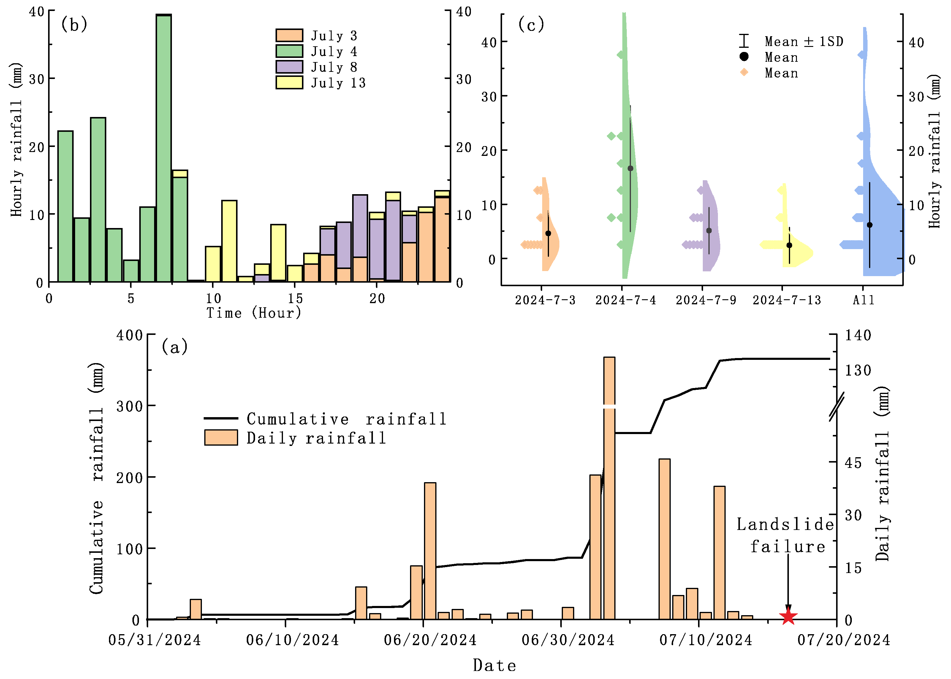
The rainfall data from June to July 2024 are shown in Figure 3. The landslide had obvious deformation and failed on 17 July 2024. Consequently, we collected the rainfall data from the nearby automatic precipitation monitoring station (located in the Yakou landslide, with a distance from the Wanshuitian landslide of approximately 11 km). The Three Gorges Reservoir area enters the rainy season in June, with a gradual increase in rainfall post-16 June. The daily rainfall in June ranged between 0.2 and 2 mm, except on 20 (15.2 mm) and 21 (39 mm) June. This accounted for 65% of all rainy days (17 days). However, in July, there was a sudden surge in rainfall. In the 17 days before the landslide failed, the cumulative rainfall amounted to 282.6 mm, including 10 rainy days. Notably, two significant downpours occurred on 3–4 July and 8 July, each with a daily rainfall exceeding 40 mm. The latter day experienced an especially heavy rainfall of 133.4 mm. Interestingly, no rainfall was recorded at the time of the landslide. Furthermore, a statistical analysis of the heavy rainfall data from these four days found that the rainfall was typically concentrated within a specific time (Figure 3b,c). For instance, the rainfall on 3 July was primarily concentrated from 16:00 to 19:00 and 22:00 to 24:00; on 4 July, it was mainly focused from 0:00 to 8:00; and 9 July’s rainfall was chiefly concentrated from 17:00 to 22:00. The hourly rainfall was mostly concentrated at rates of 5–10 mm/h.

2.4. Monitoring Methods

The deformation characteristics of the landslide after its failure were determined by high-definition photography. The unmanned aerial vehicle employed in this study was a DJI Air 3 (Shenzhen Dajiang Innovation Technology Co., Ltd., Shenzhen, China), which weighs 6.5 kg and measures 830 × 732 × 378 mm. It boasts a flight duration of 46 min, a speed range of 36 to 54 km/h, and an accuracy of 10 mm.
There was minimal or no rainfall on the day of the landslide and three days prior, but the photographs revealed notable moisture disparities between the two sides of the landslide mass. Thus, we determined the moisture content of the shallow slope mass to evaluate the change in the groundwater. The volumetric water content sensor utilized was the EC-5 type, produced by Decagon Company (Pullman, WA, USA) (Table 1). This sensor functions as a capacitive device, comprising a sensor shell and a probe. The probe, approximately 40 mm in length and about 15 mm in width, is inserted directly into the soil to measure changes in its dielectric constant to determine the change in the water content of the soil. The sensor offers a measurement accuracy of 0.1%, operates at a voltage between 2.5 and 3.6 v, and can function within a temperature range of −40 °C to 50 °C. The EC-5-type water content sensor is characterized by its compactness, high measurement accuracy, excellent stability, low voltage requirements, and minimal power consumption.

3. Results

3.1. Deformation Characteristics of Wanshuitian Landslide

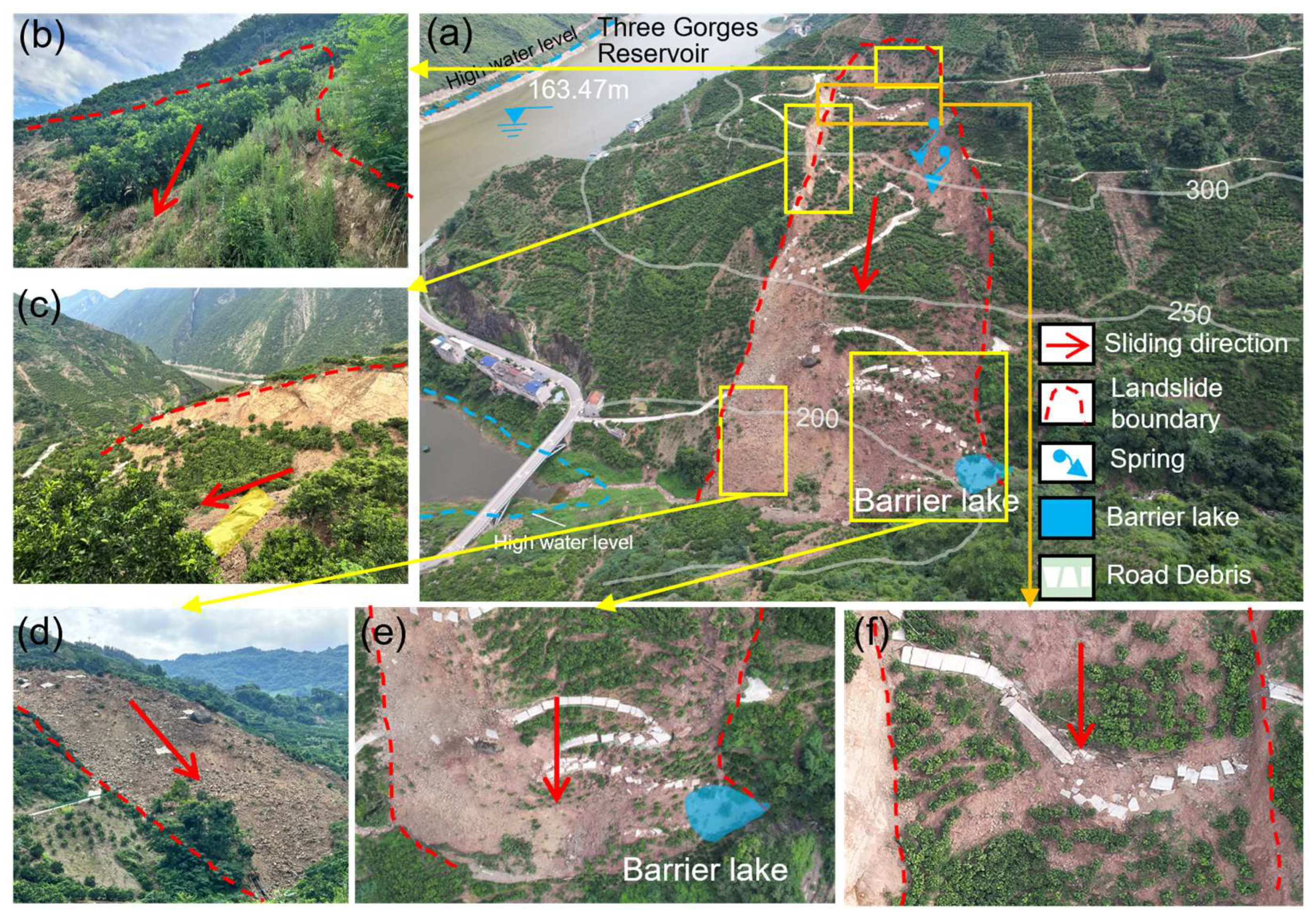
On 17 July 2024, at approximately 8:00 AM, villagers in Jiajiadian Village, Zigui County, observed an arching of the road surface on Wugao Road. By 8:40 AM, there was a significant and rapid increase in landslide deformation, which led to its total destruction within approximately 40 min. This event resulted in damage to 1200 m of the highway and 60 acres of citrus orchards. The maximum horizontal displacement of the landslide was approximately 50 m (Figure 4a). The vertical height of the two boundaries of the landslide was approximately 10 m (Figure 4b,c). The western boundary was primarily composed of soil layers, whereas the eastern boundary consisted of rock layers, marked by distinct scratches on the rock surface. The road at the rear edge sustained significant damage, with the road debris on the slope largely maintaining continuity. However, multiple cracks penetrated the road on the eastern side of the sliding body area (Figure 4a). These cracks ran parallel to the landslide’s sliding direction, with the width of the cracks being wider downstream and narrower upstream. The middle road remained relatively intact, devoid of penetrating cracks. The road surface on the western side of the slope was fractured. The cracks in the central part of the landslide slope were perpendicular to the sliding direction of the landslide, and the slope road was generally continuous and intact. The east–west road cracks ran parallel to the sliding direction of the landslide, while the north–south road cracks were perpendicular to it, with the cracks being evenly distributed (4–5 m) (Figure 4f). Spring water was exposed in the center of the landslide. The front edge of the landslide was elevated, and the deformation of the slope body on the eastern side was significant, primarily composed of crushed stones, with the road being broken (Figure 4d,e).

3.2. Displacement of Landslide Surface

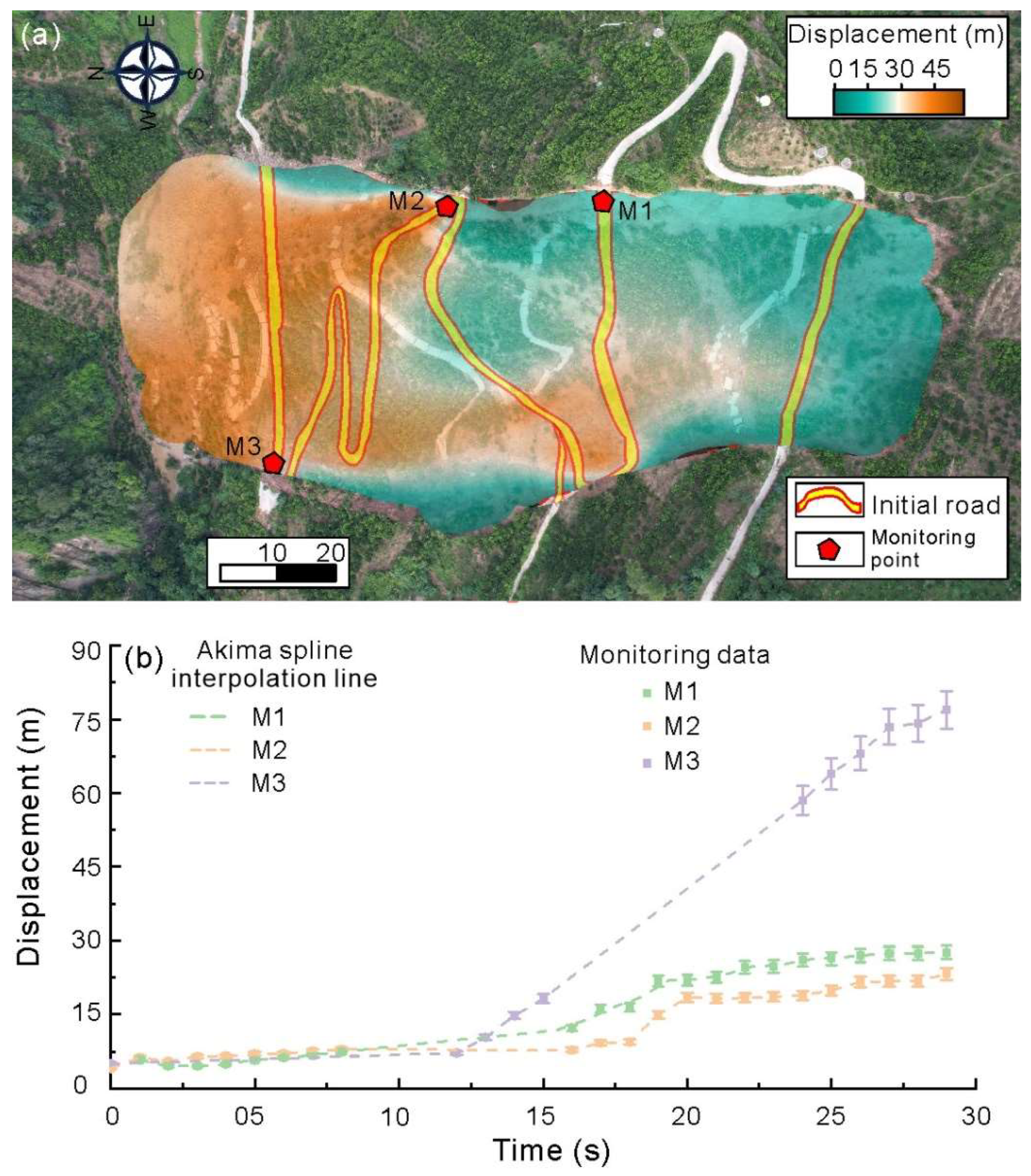
Based on the visual data captured by local villagers, we utilized buildings as the displacement identification markers, such as roads as reference points, to estimate the changes in displacement during the landslide deformation process. Figure 5a presents the estimated final deformation of the landslide. The maximum displacement of the landslide body occurred in the downstream part (about 50 m) and gradually decreased from the downstream to the upstream parts. The deformation can be obviously divided into two sections, separated by a boundary line at an elevation of 275 m. Above this elevation, the overall deformation of the slope body was relatively minor, around 15–20 m, with the west side (20–30 m) experiencing significantly greater deformation than the east side (10–18 m). Below a 275 m elevation, the deformation of the slope body markedly increased, exceeding 40 m. Figure 5b shows the displacement of the monitoring points on the landslide surface during the accelerated deformation process of the landslide. Within 0–13 s, the displacements of the M1–M3 monitoring points were roughly similar (about 7–10 m) and increased at a consistent rate (with the velocity ranging from 0.2 to 0.4 m/s). After 13 s, the displacement difference between the monitoring points significantly increased, with the displacement for M3 rapidly increasing (at a rate of 4.8 m/s). After 27 s, the velocity dropped sharply, and the displacement reached approximately 74 m. The displacement curves for M2 and M1 show a similar pattern, with the deformation gradually accelerating after 16 s and stabilizing after 20 s.

3.3. Water Content of Deposit

Field investigations revealed varying moisture contents across different regions of the deposit. We conducted measurements on the shallow soil body of the slope (Figure 6a), which showed an obviously different distribution in the moisture content. The moisture content of the deposit decreased progressively from the upstream to the downstream parts, particularly below an elevation of 290 m, where it increased greatly to over 30%. Within the elevation range of 290–320 m, the average moisture content for the western half was 20–25%, while that for the eastern half was around 16–20%. Below an elevation of 290 m, the moisture content of the soil layer in the western half of the slope body was approximately 30–35%, markedly higher than that in the eastern half, which was about 16–20%. Furthermore, two groundwater outcrops were identified within the slope body (Figure 4f and Figure 6b,c), with depths of 3–4 m.

4. Discussion

4.1. Evolution Mechanism of Landslide

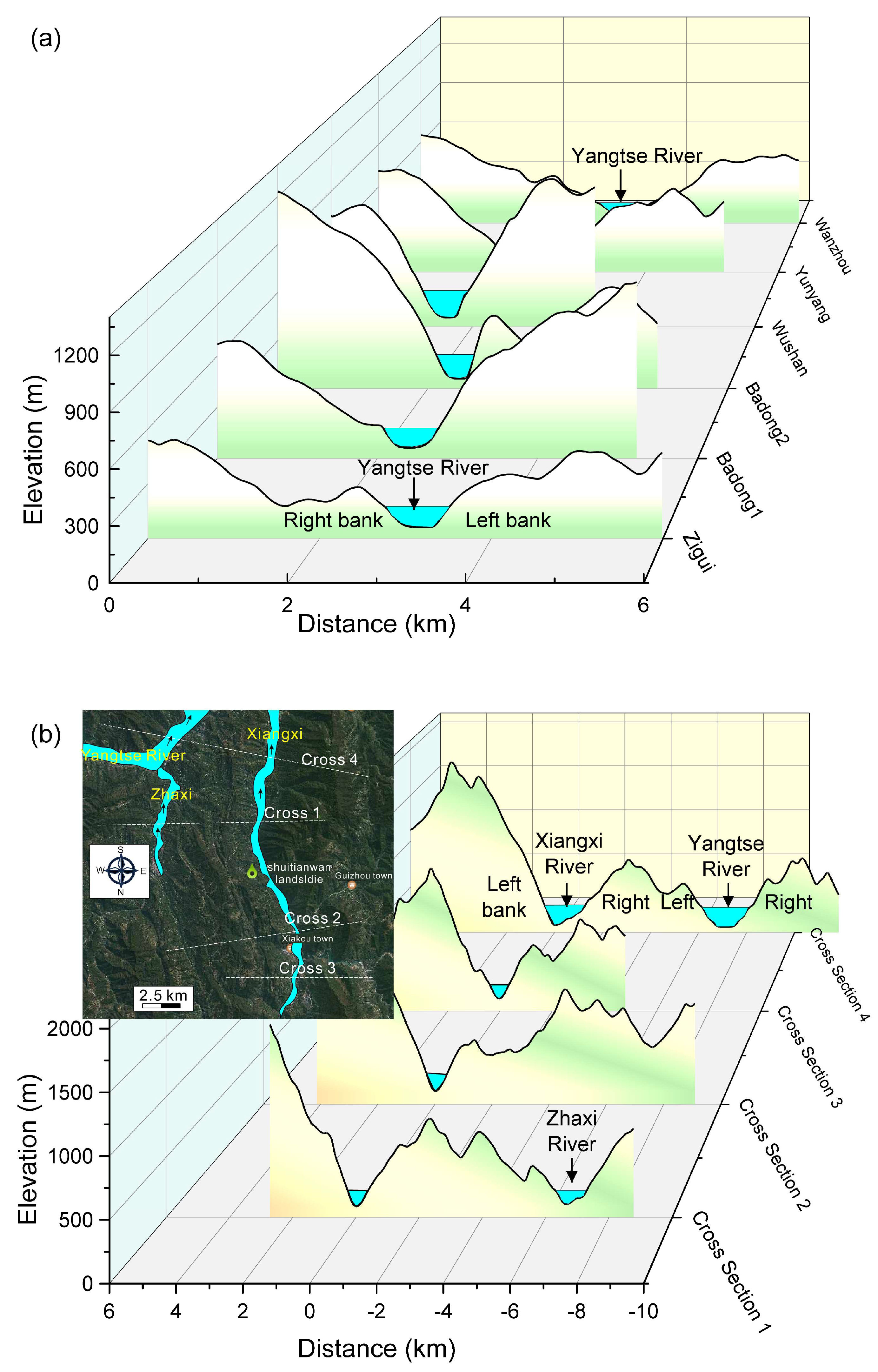
Landslides are typically associated with the regional topography and geological structures [32]. The majority of landslides in the Zigui Basin occurred on the left bank of the Xiangxi River, due to the bedding slope’s susceptibility to large-scale landslides, and those that occurred on the right bank with a stepwise sliding surface developed due to differential weathering on the interbedded mudstone and sandstone [33]. In contrast, the Three Gorges Reservoir area, characterized by a U-shaped river valley with similar slopes on both banks (Figure 7a), has recorded numerous landslides that developed on both sides [34]. The weathering and erosion of mudstone on both sides of the Xiangxi River Valley have led to the development of a number of accumulation landslides on the right bank of the river valley [35]. The left bank, while challenging to accumulate residual matter due to stratigraphic reasons, is prone to bedding landslides, such as the Majiagou landslide, on the left bank of the Zhaxi River [36]. We extracted cross-sectional terrain data from the Xiangxi River Valley (Figure 7b). The left bank of the river valley features a stepwise fluctuating slope type, typical of a bedding slope, while the slope type change on the right bank is relatively minimal. When compared with the Yangtze River Valley on both sides, it becomes evident that the unique topography and geomorphology of this region are formed by the combined influence of the Xiangxi River and the Zhaxi River.
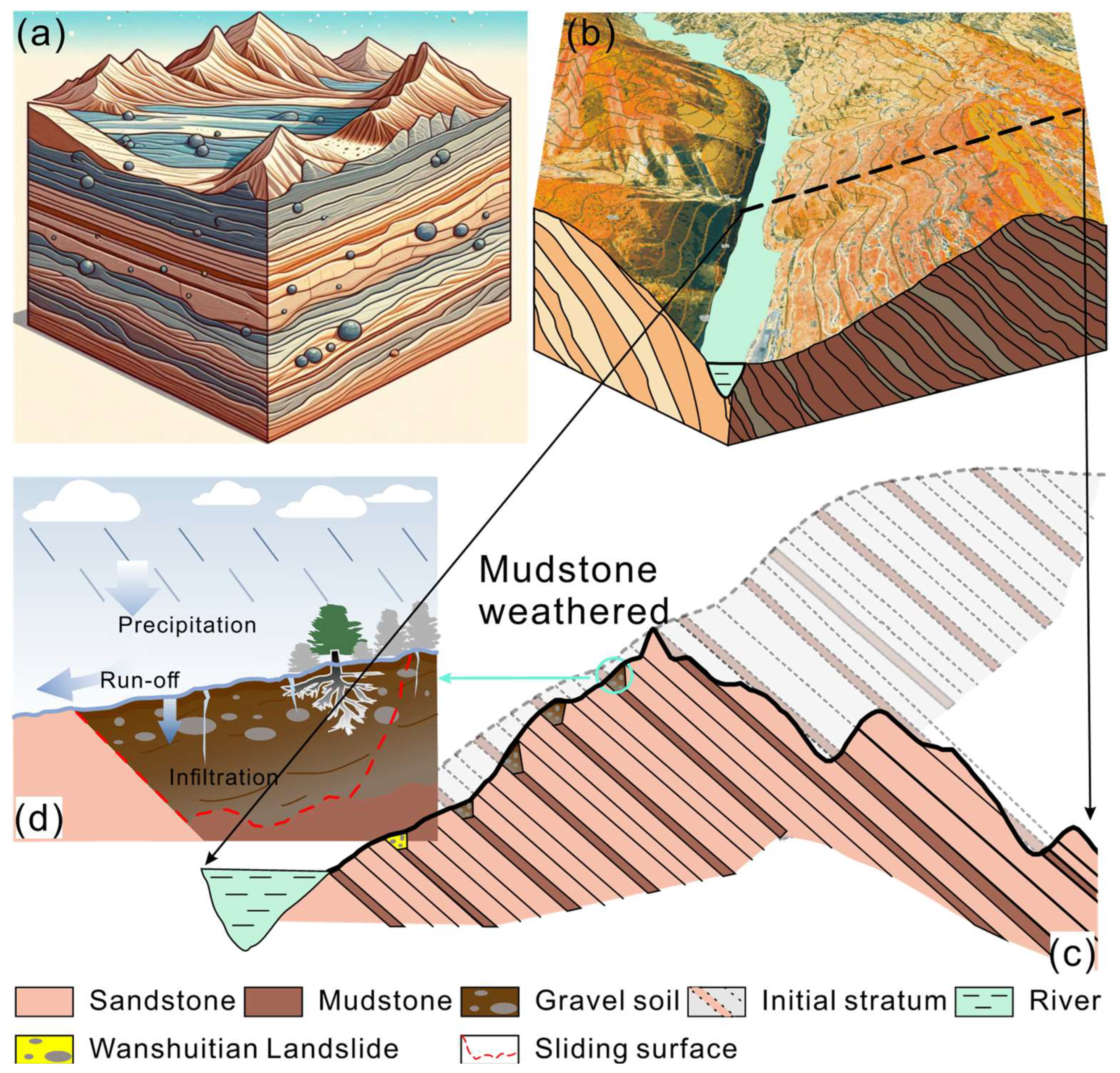
The strata in the Zigui Basin are mainly composed of interbedded sandstone and mudstone. Under tectonic action (the Zigui anticline), the rock layers tilt (Figure 8a), and under the erosion of rivers, the valley gradually cuts down. Due to the characteristics of the rock layer’s occurrence, the valley-cutting process could cause the eastern part of the bank slope to be eroded, and the slope body slides along the rock surface. Therefore, the terrain on the left bank slope is steeper and overlaps with the stratum occurrence. The right-bank slope is relatively gentle, and on the other side of the high mountain on the right is the left side of the Zhaxi River, where the topography shows the same trend (Figure 8b). From the profile, it can be seen that the terrain presents a step-like fluctuation, with fertile soil in the troughs where a large amount of crops is planted (Figure 8c). This indicates that due to differential weathering between sandstone and mudstone, mudstone is more easily weathered [37], and after losing support, the overlying sandstone collapses, forming a trough. This differential weathering and erosion make it easy for landslides to occur on the right bank of the Xiangxi River with step-like sliding surfaces. The Wanshuitian landslide is another type of landslide in this area, developed in residual layers. Its formation process is mudstone weathering, forming wedge-shaped residual layers. The right-bank slope is a reverse slope, and the residual layer is not easy to slide. The residual layer has fertile soil, and a large number of citrus trees are planted on the slope, with single vegetation promoting surface water infiltration and stratum instability (Figure 8d).
The Zigui Basin’s landslides have been extensively studied, with a primary focus on three typical failure models [33]: anti-dip slope landslide with a circular failure surface, over-dip slope landslide with the failure surface along the bedding plane, and under-dip slope landslide with an irregular failure surface. The Shuitianwan landslide introduces a fourth failure model (Figure 9). This particular landslide transpired within a soil layer with an irregular failure surface, which was situated between two rock layers, thereby classifying it as an oblique-dip slope wedge landslide. The most prominent feature of this type of landslide is that it forms wedge-shaped residual layers, and the right-bank slope is a reverse slope.
Citrus trees contributed to enhancing the water retention capacity of the slope surface, slowing down the surface runoff velocity and increasing both the rainfall infiltration time and volume. At the same time, the development of large pores in the geotechnical layer under citrus tree coverage significantly enhanced the permeability of the soil. Due to the larger root system of citrus trees, the dominant flow effect became more pronounced, further promoting infiltration and reducing landslide stability [38,39]. Because the landslide slope was 20°, it was not easy for water to accumulate on the slope surface, and rainfall infiltration was slow, so the landslide occurred on the 5th day after heavy rainfall. Within hours after the landslide was destroyed, two groundwater outflow points (S1 and S2) appeared, and the moisture content in the western half of the landslide body was significantly higher than that on the east side, indicating that groundwater from the landslide replenished from west to east. It is speculated that the direct triggering factor of this landslide was not heavy rainfall, but rather heavy rainfall, causing shallow groundwater levels to rise and gradually infiltrate into deep mudstone layers, with deformation first occurring in the western part. Therefore, the response of the landslide obviously lagged behind the rainfall.
There are two mechanisms of landslide instability caused by rainfall: a decrease in soil matric suction due to rain infiltration and an increase in the groundwater level with the consequent generation of positive pore water pressures [40,41]. After the rainfall stopped, the pore water pressure and volume water content of the deep slope continued to change with the same trend as before the end of the rainfall for a period of time [42]. The volume water content and pore water pressure continued to increase, and matric suction continued to decrease, which continued to decrease the stability coefficient for some time after the rainfall stopped. This can be regarded as the direct cause of the landslide lagging after the rainfall.
Fortunately, no casualties were reported, and farmers were able to evacuate immediately thanks to the geological disaster joint prevention and control system. The specific features of the joint prevention and control system were as follows: (a) Regular training enabled residents to understand landslide disasters. (b) Once landslide occurrences were detected, nearby residents were immediately notified to evacuate urgently [43]. After the landslide disaster occurred, administrative authorities responded promptly and mobilized effectively. Firstly, the dangerous area was delineated, and notable personnel were arranged to work around the landslide to prevent unauthorized personnel and vehicles from entering the landslide area. Secondly, the landslide movement was closely monitored. Thirdly, the disaster situation was further verified [44].

4.2. Stability Prediction of Oblique-Dip Slope Wedge Landslide

Based on the satellite imagery presented in Figure 10, a total of 15 landslides were identified on the right bank of the Xiangxi River, exhibiting several characteristics akin to those observed in the Wanshuitian landslide. The primary features were as follows: (1) The landslides occurred in a direction that was parallel to the river. (2) The mean slope angles of these landslides were found to fall within the range of 25° to 40°, exhibiting a normal distribution (Figure 10f). (3) The cross-sections of these landslides exhibited similar characteristics: the eastern boundary was delineated by a rock layer with an extremely flat surface and a slope ranging between 25° and 35°, while the right side featured a steeper incline. (4) Certain landslides were characterized by ridges on either side, with a densely vegetated slope body in the center, inferring that the two sides of these landslides consisted of exposed rock layers, and they were also developed in the interbedded weak (soil) and hard (sandstone) stratum layers. Therefore, the oblique-dip slope wedge landslides were widely distributed in the study area.
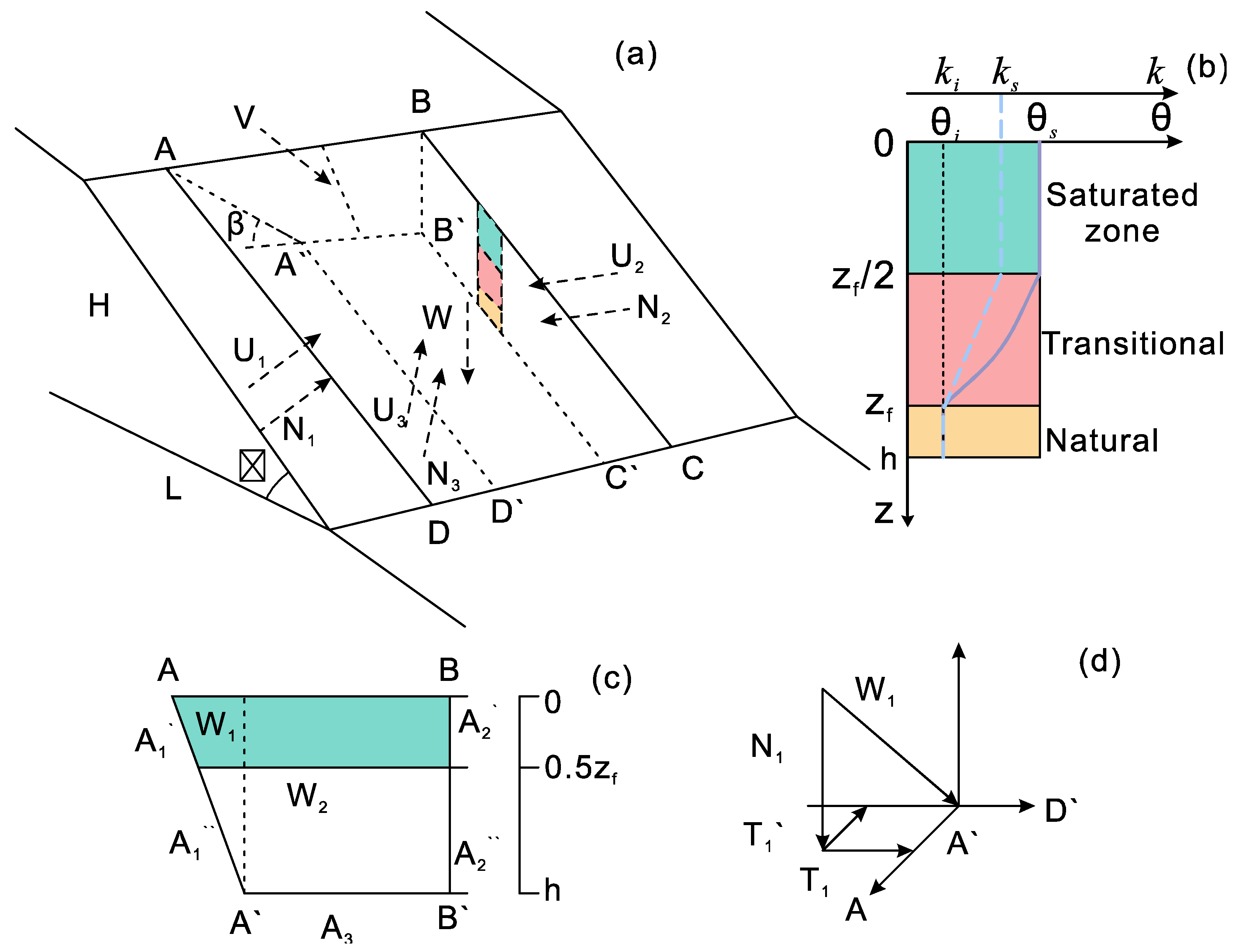
Based on the geological and hydrological conditions of the Wanshuitian landslide, we simplified the wedge failure mode of this particular type of landslide (Figure 11) [24]. The left boundary of the model is defined by the rock layer surface, while the right side corresponds to the vertical residual layer fracture surface. The bottom boundary of the landslide represents the sliding surface. The loads acting on the model contain the weight of the wedge body itself, the effective normal force, and the water pressure. Plane BCC′B′ experiences a normal stress denoted as N 2 , while plane ADD′A′ primarily undergoes forces including overlying soil weight, normal effective stress, water pressure, and frictional force (Figure 11a,d). The overlying soil weight can be further decomposed into a normal stress component in the reverse direction, a downhill force component aligned with the sliding direction, and a force component perpendicular to the strike direction of the rock layer. Consequently, the calculations for the forces acting on these three interfaces are as follows:
N 2   =   η γ h
N 1 = W 1 c o s β
N 3 = W 2 s i n α
T = T 1 + T 2 + V
T 1 = W 1 s i n β c o s α
T 2 = W 2 c o s α
where α is the dip of the sliding zone. N is the effective normal force. γ is the unit weight of the soil. η is the stress ratio. h is the thickness of the sliding mass. β is the dip angle of the rock layer. W 1 is the weight of the left triangular part. W 2 is the weight of the right part. T is the sliding force of the model. V is the force from the upstream part of the landslide.
We utilized the improved Green–Ampt model, as proposed by Chen et al. [45], to compute the alterations in the slope seepage field during each rainfall event (Figure 11b). This model considers the correlation between rainfall intensity and, specifically, moisture content and soil depth. It categorizes the infiltration of rainfall into the soil body into three zones: saturation, transition, and natural. The model also posits that the height of the transition zone is congruent with that of the saturation zone.
z f = q t c o s α 0.89 θ s θ i z p                               t t p
d z f d t = k z f c o s α + s f 0.89 θ s θ i z p z f | t = t p = z p ,                   t > t p
t p = I q c o s a
I = θ s θ i z p 2 + π θ s θ i z p 8
where z f is the depth of the moist sharp, which is also the rainfall infiltration depth. q is the rainfall intensity. θ s is the saturated water content of the soil. s f is the suction head of the wetting peak. z p is the rainfall infiltration depth when ponding occurs on the slope surface. I is the accumulative rainfall infiltration depth when ponding occurs on the slope surface. θ i is the initial water content of the soil.
Consequently, the resistance of both the saturated and unsaturated layers is computed independently. For the saturated layer (Figure 11c), the resistance of the stratum on either side of the interface can be articulated as follows:
F r s a t = N 1 ` t a n φ 1 s a t + N 2 ` t a n φ 2 s a t + c 1 s a t A 1 ` + c 2 s a t A 2 `
where N ` is the effective normal force above the groundwater table. A ` is the area of the saturated layer. φ s a t and c s a t are the friction and cohesion of the saturated soil.
For unsaturated layers, the resistance exhibited by the strata on either side of the interface can be articulated as follows:
F r u n s a t = N 1 ` ` t a n φ 1 + N 2 ` ` t a n φ 2 + c 1 A 1 ` ` + c 2 A 2 ` `
where N ` ` is the effective normal force in the unsaturated layers. A ` ` is the area of the unsaturated layers. φ and c are the friction and cohesion of the soil.
Therefore, the stability of the landslide can be calculated as follows:
F o s = F r s a t + F r u n s a t + N 3 t a n φ 3 + c 3 A 3 T + V
Due to the limitations of the experiment, we were unable to obtain the geotechnical parameters of the Wanshuitian landslide to verify the reliability of the stability prediction model. Instead, we selected the geotechnical parameters of the Maiganggou landslide as the calculation parameters, which were consistent with the geotechnical properties of the Wanshuitian landslide [46] (Table 2). Taking into account the uncertainty and randomness of the soil parameters, it was feasible to develop the stability prediction methodology for the oblique-dip slope wedge landslide and determine the rainfall infiltration depth threshold of the Wanshuitian landslide. To simplify the calculation, the sliding mass was simplified as homogeneous soil and hydrological conditions. Given that the landslide duration was a mere 40 min, from the initial detection of cracks to its final failure, and there had been no rainfall for three days prior to the failure, we did not account for the formation of back boundary cracks. Moreover, the landslide’s trailing edge was proximate to the ridge. Thus, the force from the upstream part of the landslide V was set to 0 kPa. The results of the stability factors of the Wanshuitian landslide after four rainfall events are shown in Table 3. Four rainfall events resulted in landslide stability coefficients all less than 1.
Furthermore, when the slope reaches a critical state, the stability coefficient of the slope ( F o s ) is equal to 1. We can determine the critical infiltration depth of groundwater for this specific type of landslide. In our study of this landslide type, variations in the rock layer dip angle, slope gradient, and geotechnical parameters were relatively minor; therefore, we considered them constant. We examined the correlation between the landslide stability coefficient and the thickness of the sliding mass, also known as the landslide scale. The rainfall infiltration depth coefficient is denoted as ϑ   = z f h . By incorporating this into the aforementioned equation, we can establish the relationship between the critical depth coefficient and the thickness h of the sliding mass.
1.11 h 2 ϑ c r 2 + 40.45 h 2 + 39.9 h 22553 ϑ c r 0.92 h 2 + 159.1 h + 15806.32 = 0
Since the critical depth coefficient is the ratio of the rainfall infiltration depth to the landslide thickness, its approximate value range is (0, 2).
ϑ c r = 0.074 h 4 0.18 h 3 + 79 × h 2 81 h + 2.3 × 10 4 × 10 3 h 2 + 18.2 18 h + 1.02 × 10 4 h 2
Therefore, for the Wanshuitian landslide, the thickness of the sliding mass was 20 m, and its critical rainfall infiltration depth coefficient was 0.49, that is, the rainfall infiltration depth was 9.8 m.

5. Conclusions

The distinct weathering and river erosion of the Jurassic mudstone–sandstone interbedded strata in the Zigui Basin, located in Zigui County, China, have resulted in a unique geological structure. This structure is characterized by residual layers and sandstone interbeds on either side of the Xiangxi River and Zhaxi River Valleys. This has given rise to a fourth type of landslide: the oblique wedge landslide. This paper used the Wanshuitian landslide as a case study to analyze the deformation characteristics, geological evolution process, and stability prediction model of this specific landslide type. The conclusions are as follows:
The Wanshuitian landslide, which occurred from 3 to 13 July, was precipitated by four heavy rainfalls. Notable deformation commenced on the 17th, culminating in a rapid failure of approximately 40 min. This catastrophic event resulted in the destruction of roads and farmland, as well as the formation of a small dammed lake at the base of the slope. The eastern boundary of the landslide was characterized by a distinct rock layer, while the left side featured a residual layer. The landslide body was situated between two sandstone layers, exhibiting a uniform sliding characteristic overall. However, upon crossing the middle and front parts of the landslide, these sections experienced accelerated deformation.
The geological structure of the Jurassic sandstone and mudstone interlayer, subjected to differential weathering and erosion, has resulted in a stepwise fluctuating terrain on the river valley’s left bank and a unique stratigraphic structure of residual layers–sandstone interlayers on the right bank. These geological features significantly influence landslide disasters in this region. Persistent heavy rainfall seeps downward along the rock layer interface and the residual layer within the sandstone layer. Additionally, the planting of individual citrus plants further accelerates the rate of rainfall infiltration, leading to quicker infiltration in the shallow slope body. Given the deep burial of the sliding surface, the initiation time for landslides is notably delayed compared with the rainfall event.
Considering the variations in the moisture content and the permeability coefficient with depth, rainfall intensity, and duration during the infiltration process, a stability prediction model for oblique wedge landslides was developed using an improved Green–Ampt model. This model facilitated the determination of the critical rainfall infiltration depth for such landslides. Using the Wanshuitian landslide as a case study, the stability coefficient following four consecutive rainfall events was calculated, revealing a critical rainfall infiltration depth of 9.8 m. This study aimed not merely to sharpen the evolution mechanism and stability prediction of the Wanshuitian landslide but also to formulate more effective landslide-monitoring strategies and emergency management measures.

Author Contributions

Methodology, C.X. and C.Z.; investigation, W.H.; data curation, W.H.; writing—review and editing, C.X. and C.Z.; funding acquisition, C.X. and C.Z. All authors have read and agreed to the published version of the manuscript.

Funding

This research was funded by the National Natural Science Foundation of China (42307227, 42207169), the Open Fund of Badong National Observation and Research Station of Geohazards (BNORSG202315, BNORSG202413).

Institutional Review Board Statement

Not applicable.

Informed Consent Statement

Not applicable.

Data Availability Statement

The raw data supporting the conclusions of this article will be made available by the authors on request.

Acknowledgments

The authors declare that the AI tools had no role in the data analysis and interpretation in the research process and were only applied to improve the language and readability of the text.

Conflicts of Interest

The authors declare no conflict of interest.

References

  1. Huang, F.; Chen, J.; Liu, W.; Huang, J.; Hong, H.; Chen, W. Regional rainfall-induced landslide hazard warning based on landslide susceptibility mapping and a critical rainfall threshold. Geomorphology 2022, 408, 108236. [Google Scholar] [CrossRef]
  2. Amarasinghe, M.P.; Kulathilaka, S.A.S.; Robert, D.J.; Zhou, A.; Jayathissa, H.A.G. Risk assessment and management of rainfall-induced landslides in tropical regions: A review. Nat. Hazards 2024, 120, 2179–2231. [Google Scholar] [CrossRef]
  3. Dikshit, A.; Sarkar, R.; Pradhan, B.; Segoni, S.; Alamri, A.M. Rainfall induced landslide studies in Indian Himalayan region: A critical review. Appl. Sci. 2020, 10, 2466. [Google Scholar] [CrossRef]
  4. Yang, H.; Lu, Y.; Wang, J. Stability Analysis of the Huasushu Slope Under the Coupling of Reservoir Level Decline and Rainfall. Appl. Sci. 2025, 15, 5781. [Google Scholar] [CrossRef]
  5. Zhang, Z.; Zeng, R.; Meng, X.; Zhao, S.; Wang, S.; Ma, J.; Wang, H. Effects of changes in soil properties caused by progressive infiltration of rainwater on rainfall-induced landslides. Catena 2023, 233, 107475. [Google Scholar] [CrossRef]
  6. Hou, R.; Li, Z.; Ye, W.; Peng, T.; Tian, S.; Chen, N.; Huang, N.; Valenzuela, M.S. A small landslide induced a large disaster prior to the heavy rainy season in Jinkouhe, Sichuan, China: Characteristics, mechanism, and lessons. Landslides 2024, 21, 1353–1365. [Google Scholar] [CrossRef]
  7. Shao, X.; Yan, W.; Yan, C.; Zhao, W.; Wang, Y.; Shi, X.; Dong, H.; Li, T.; Yu, J.; Zuo, P.; et al. Explainable Machine Learning for Mapping Rainfall-Induced Landslide Thresholds in Italy. Appl. Sci. 2025, 15, 7937. [Google Scholar] [CrossRef]
  8. Ramya, A.; Poornima, R.; Karthikeyan, G.; Priyatharshini, S.; Thanuja, K.G.; Dhevagi, P. Climate-induced and geophysical disasters and risk reduction management in mountains regions. In Climate Change Adaptation, Risk Management and Sustainable Practices in the Himalaya; Springer International Publishing: Cham, Switzerland, 2023; pp. 361–405. [Google Scholar]
  9. Ponziani, M.; Ponziani, D.; Giorgi, A.; Stevenin, H.; Ratto, S.M. The use of machine learning techniques for a predictive model of debris flows triggered by short intense rainfall. Nat. Hazards 2023, 117, 143–162. [Google Scholar] [CrossRef]
  10. Durukan, S. Evaluation of the Antecedent Saturation and Rainfall Conditions on the Slope Failure Mechanism Triggered by Rainfalls. Appl. Sci. 2024, 14, 9478. [Google Scholar] [CrossRef]
  11. Wang, C.H.; Fang, L.; Chang, D.T.T.; Huang, F. Back-analysis of a rainfall-induced landslide case history using deterministic and random limit equilibrium methods. Eng. Geol. 2023, 317, 107055. [Google Scholar] [CrossRef]
  12. Riaz, M.T.; Basharat, M.; Ahmed, K.S.; Shahzad, A.; Shah, N.A. Failure mechanism of a massive fault–controlled rainfall–triggered landslide in northern Pakistan. Landslides 2024, 21, 2741–2767. [Google Scholar] [CrossRef]
  13. Zhou, C.; Ai, D.; Huang, W.; Xu, H.; Ma, L.; Chen, L.; Wang, L. Emergency survey and stability analysis of a rainfall-induced soil-rock mixture landslide at Chongqing City, China. Front. Earth Sci. 2021, 9, 774200. [Google Scholar] [CrossRef]
  14. Song, K.; Yang, H.; Liang, D.; Chen, L.; Jaboyedoff, M. Step-like displacement prediction and failure mechanism analysis of slow-moving reservoir landslide. J. Hydrol. 2024, 628, 130588. [Google Scholar] [CrossRef]
  15. Zhuang, Y.; Xing, A.; Sun, Q.; Jiang, Y.; Zhang, Y.; Wang, C. Failure and disaster-causing mechanism of a typhoon-induced large landslide in Yongjia, Zhejiang, China. Landslides 2023, 20, 2257–2269. [Google Scholar] [CrossRef]
  16. Xue, D.; Dai, C.; Wu, Y.; Chen, K.; Tang, J.; Zhang, S. A catastrophic rainfall-induced high landslide, occurred on December 4, 2020, in the Qingliucun mountainous area of Southwest China. Landslides 2023, 20, 2187–2197. [Google Scholar] [CrossRef]
  17. Wang, S.; Demisa, M.G.; Han, B.; Hou, Q.; Zhang, Z. A material point method analysis of failure mechanism and kinematic behavior of rainfall-induced landslide. Nat. Hazards 2024, 120, 13875–13897. [Google Scholar] [CrossRef]
  18. Xu, F.; Hu, H.; Lin, H.; Xie, L. Bedding Slope Destabilization under Rainfall: A Case Study of Zhuquedong Slope in Hunan Province, China. Appl. Sci. 2024, 14, 1394. [Google Scholar] [CrossRef]
  19. Qin, Y.; Yang, G.; Liu, B.; Xu, J. Study on deformation and failure mechanism of low-dip red bed slope with soft-hard interbedded structure: A case study of Chishui, China. Nat. Hazards 2024, 120, 10539–10557. [Google Scholar]
  20. Yu, H.; Li, C.; Zhou, J.Q.; Chen, W.; Long, J.; Wang, X.; Peng, T. Recent rainfall-and excavation-induced bedding rockslide occurring on 22 October 2018 along the Jian-En expressway, Hubei, China. Landslides 2020, 17, 2619–2629. [Google Scholar] [CrossRef]
  21. Tao, T.; Shi, W.; Liang, F.; Wang, X. Failure mechanism and evolution of the Jinhaihu landslide in Bijie City, China, on January 3, 2022. Landslides 2022, 19, 2727–2736. [Google Scholar] [CrossRef]
  22. Pei, X.; Cui, S.; Zhu, L.; Wang, H.; Luo, L.; Zhang, X. Sanxicun landslide: An investigation of progressive failure of a gentle bedding slope. Nat. Hazards 2022, 111, 51–78. [Google Scholar] [CrossRef]
  23. Jiang, Q.; Liu, X.; Wei, W.; Zhou, C. A new method for analyzing the stability of rock wedges. Int. J. Rock Mech. Min. Sci. 2013, 60, 413–422. [Google Scholar] [CrossRef]
  24. Troncone, A.; Pugliese, L.; Parise, A.; Conte, E. Prediction of slow-moving landslide mobility due to rainfall using a two-wedges model. Water 2021, 13, 2030. [Google Scholar] [CrossRef]
  25. Kumsar, H.; Aydan, Ö.; Ulusay, R. Dynamic and static stability assessment of rock slopes against wedge failures. Rock Mech. Rock Eng. 2000, 33, 31–51. [Google Scholar] [CrossRef]
  26. Zhang, S.; Xu, Q.; Peng, D.; Zhu, Z.; Li, W.; Wong, H.; Shen, P. Stability analysis of rock wedge slide subjected to groundwater dynamic evolution. Eng. Geol. 2020, 270, 105528. [Google Scholar] [CrossRef]
  27. Jimenez-Rodriguez, R.; Sitar, N.; Chacón, J. System reliability approach to rock slope stability. Int. J. Rock Mech. Min. Sci. 2006, 43, 847–859. [Google Scholar] [CrossRef]
  28. Ambartzumian, R.; Der Kiureghian, A.; Ohaniana, V.; Sukiasiana, H. Multinormal probability by sequential conditioned importance sampling: Theory and application. Probabilistic Eng. Mech. 1998, 13, 299–308. [Google Scholar] [CrossRef]
  29. Song, J.; Der Kiureghian, A. Bounds on system reliability by linear programming. J. Eng. Mech. 2003, 129, 627–636. [Google Scholar] [CrossRef]
  30. Tamrakar, N.K.; Singh, J.L.; Bista, K.K.; Maharjan, P. Toppling and wedge failures in Malekhu River area, Malekhu, Central Nepal Lesser Himalaya. Bull. Dep. Geol. 2013, 16, 21–28. [Google Scholar] [CrossRef]
  31. Ye, Z.; Xie, J.; Lu, R. Simulation of Seismic Dynamic Response and Post-failure Behavior of Jointed Rock Slope Using Explicit Numerical Manifold Method. Rock Mech. Rock Eng. 2022, 55, 6921–6938. [Google Scholar] [CrossRef]
  32. Zhou, C.; Ma, W.; Sui, W. Transparent soil model test of a landslide with umbrella-shaped anchors and different slope angles in response to rapid drawdown. Eng. Geol. 2022, 307, 106765. [Google Scholar] [CrossRef]
  33. Li, C.; Fu, Z.; Wang, Y.; Tang, H.; Yan, J.; Gong, W.; Yao, W.; Criss, R.E. Susceptibility of reservoir-induced landslides and strategies for increasing the slope stability in the Three Gorges Reservoir Area: Zigui Basin as an example. Eng. Geol. 2019, 261, 105279. [Google Scholar] [CrossRef]
  34. Tang, H.; Wasowski, J.; Juang, C.H. Geohazards in the three Gorges Reservoir Area, China–Lessons learned from decades of research. Eng. Geol. 2019, 261, 105267. [Google Scholar] [CrossRef]
  35. Li, C.; Criss, R.E.; Fu, Z.; Long, J.; Tan, Q. Evolution characteristics and displacement forecasting model of landslides with stair-step sliding surface along the Xiangxi River, three Gorges Reservoir region, China. Eng. Geol. 2021, 283, 105961. [Google Scholar] [CrossRef]
  36. Hu, X.; Tan, F.; Tang, H.; Zhang, G.; Su, A.; Xu, C.; Zhang, Y.; Xiong, C. In-situ monitoring platform and preliminary analysis of monitoring data of Majiagou landslide with stabilizing piles. Eng. Geol. 2017, 228, 323–336. [Google Scholar] [CrossRef]
  37. Wu, Q.; Liu, Y.; Tang, H.; Kang, J.; Wang, L.; Li, C.; Wang, D.; Liu, Z. Experimental study of the influence of wetting and drying cycles on the strength of intact rock samples from a red stratum in the Three Gorges Reservoir area. Eng. Geol. 2023, 314, 107013. [Google Scholar] [CrossRef]
  38. Devitt, D.A.; Smith, S.D. Root channel macropores enhance downward movement of water in a mojave desert ecosystem. J. Arid Environ. 2002, 50, 99–108. [Google Scholar] [CrossRef]
  39. Li, X.; Gao, S.; Zhou, C.; Wang, Y.; Zhong, Q.; Chen, Q. Improved Green-Ampt model considering effects of microbial mineralization and vegetation in biological restoration of slopes. Chin. J. Geotech. Eng. 2023, 45, 1953–1962. [Google Scholar]
  40. Zhang, J.; Li, J. Delay Failure Mechanism of Rainfall-Caused Shallow Landslide. Geotech. Geol. Eng. 2018, 36, 2293–2304. [Google Scholar] [CrossRef]
  41. Conte, E.; Pugliese, L.; Troncone, A. A simple method for predicting rainfall-induced shallow landslides. J. Geotech. Geoenvironmental Eng. 2022, 148, 04022079. [Google Scholar] [CrossRef]
  42. Hou, R.; Chen, N.; Hu, G.; Han, Z.; Liu, E. Characteristics, mechanisms, and post-disaster lessons of the delayed semi-diagenetic landslide in Hanyuan, Sichuan, China. Landslides 2022, 19, 437–449. [Google Scholar] [CrossRef]
  43. Dou, J.; Xing, K.; Lu, Z.; Peng, B.; Peng, Y.; Guo, F. Comprehensive analysis of July 17, 2024, heavy rainfall-induced landslide at Zigui County in the Three Gorges Reservoir Area, China. Landslides 2025, 22, 957–965. [Google Scholar] [CrossRef]
  44. Ding, Y.; Xia, Z.; Rao, Y.; Chen, H.; Gan, W. Preliminary analysis of Wuyigou landslide on 17 July 2024 in Zigui County, Hubei Province, China. Landslides 2025, 22, 261–266. [Google Scholar] [CrossRef]
  45. Chen, J.; Li, S.; Luo, X.; Zhu, S.; Wu, L. Animproved Green Ampt model and its experimental verification. J. Eng. Geol. 2023, 31, 1728–1737. [Google Scholar]
  46. Zhang, Y.; Hu, X.; Tannant, D.D.; Zhang, G.; Tan, F. Field monitoring and deformation characteristics of a landslide with piles in the Three Gorges Reservoir area. Landslides 2018, 15, 581–592. [Google Scholar] [CrossRef]
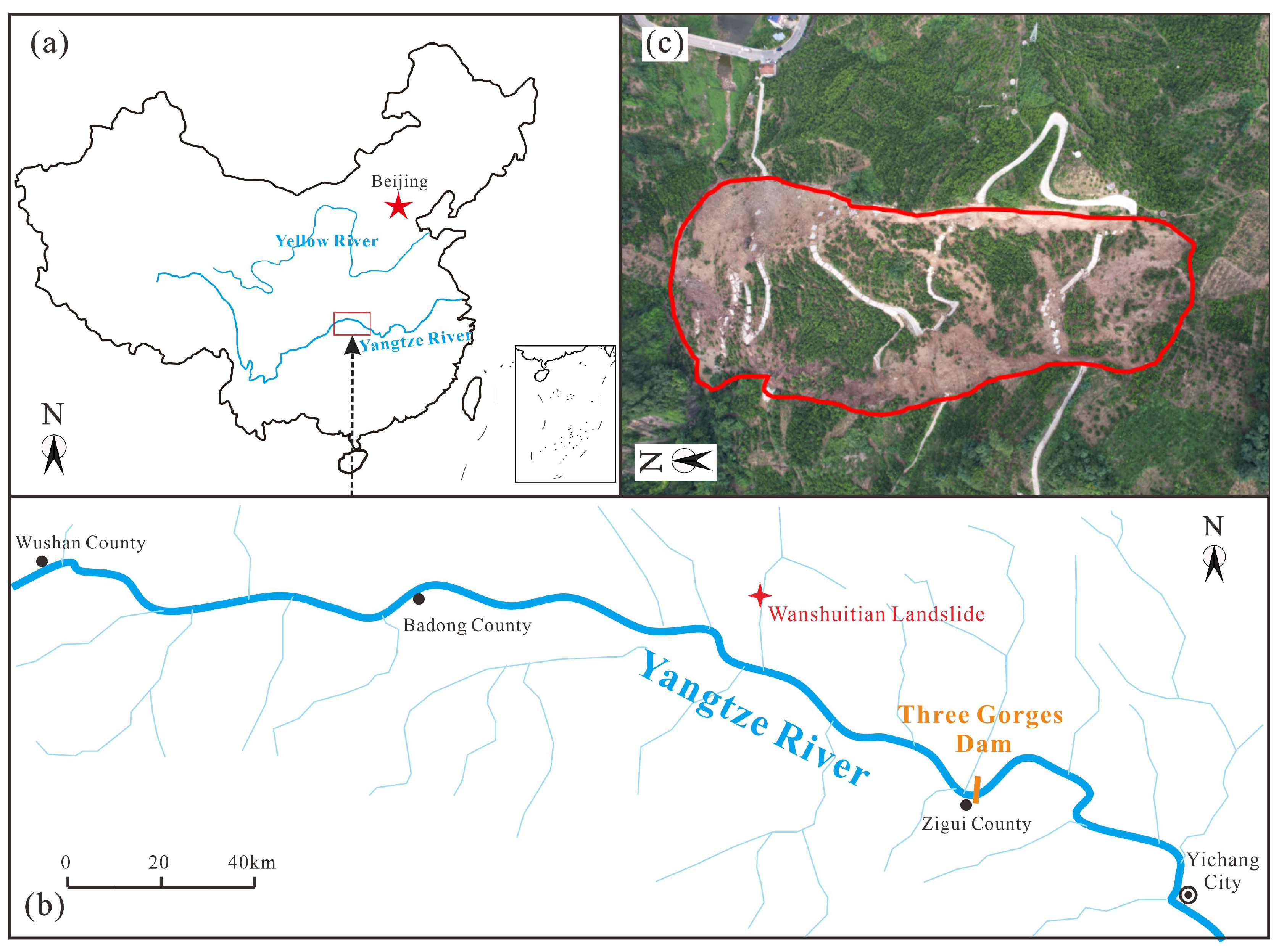
Figure 1. (a,b) The location of the Wanshuitian landslide and (c) its plan view in an unmanned aircraft image after the landslide.
Applsci 15 09194 g001
Figure 2. (a) Three-dimensional topographic maps, (b) the profile of the landslide, (c,d) interbedded sandstone and mudstone bedrock, and (e) the outcrop on the west side of the landslide.
Applsci 15 09194 g002
Figure 3. (a) Time distribution of several extreme rainfall events, (b) hourly rainfall of several extreme rainfall events, (c) the daily rainfall in the study area from June to July.
Applsci 15 09194 g003
Figure 4. (a) The deformation characteristics, (b) the left boundary, (c) the right boundary, (d) the slip tongue of the landslide, (e) the deformation of the road and barrier lake located at the landslide toe, and (f) road debris on the upstream part.
Applsci 15 09194 g004
Figure 5. (a) The post-landslide topography and displacement content and (b) the displacement of the monitoring points based on the video. The video was recorded by residents with a mobile phone during the landslide, lasting for 29 s. The road and other distinguishable structures were selected as measurement points. Due to the change in the camera angle, sometimes, the points were not recorded.
Applsci 15 09194 g005
Figure 6. (a) The water content of the soil in the shallow landslide; (b,c) two springs located on the western boundary of the landslide with approximately depths of 3 m (S1) and 4 m (S2), respectively.
Applsci 15 09194 g006
Figure 7. Morphometric analysis of the cross-sections of (a) the Yangtze River and (b) Xiangxi River Valleys.
Applsci 15 09194 g007
Figure 8. The geological evolution process of the study area. (a) The initial model. (b) River incision erosion, valley formation, and rainfall scouring on slopes collectively contribute to the formation of numerous gullies. The map presented herein is derived from satellite imagery of the study area, captured by Ovi Map in 2018. (c) The profile of the river valley where the landslide is located, and the initial stratum is deduced from the prevailing topographic profile and stratigraphic conditions to present the evolution process of the distinctive topography and geomorphology of this region (an interlayered residual layer–rock stratum structure) caused by differential weathering and rainfall erosion. (d) The model of rainfall infiltration within the shallow slope residual layer is presented.
Applsci 15 09194 g008
Figure 9. The four failure modes of landslides in the study area: (a) anti-dip slope landslide, (b) over-dip slope landslide, (c) under-dip slope landslide, (d) the cross-section of an oblique-dip slope wedge landslide, and (e) the longitudinal-section of an oblique-dip slope wedge landslide.
Applsci 15 09194 g009
Figure 10. (a) The similar landslide on the right bank of the Xiangxi River, (be) satellite images of some landslides, (f) the profiles of these landslides, and (g) the normal probability plot of the slope angles of these landslides.
Applsci 15 09194 g010
Figure 11. (a) The shape of the oblique-dip slope wedge landslide and its load; (b) the rainfall infiltration model obtained by the improved Green–Ampt model; (c) the stability calculation model for the landslide; and (d) the diagram of the force W1 decomposition.
Applsci 15 09194 g011
Table 1. Parameters of UAV and moisture content sensor.
ParameterValuePicture
Unmanned aerial vehicle (DJI Air 3)Weight6.5 kgApplsci 15 09194 i001
Size830 × 732 × 378 mm
Load<3.5 kg
AccuracyHorizontal: 1 cm + 1 ppm
Vertical: 2 cm + 1 ppm
Wind resistance capability5 scale
EC-5-type moisture content sensorAccuracy0.1%Applsci 15 09194 i002
Size40 × 15 mm
Working temperature−40 °C–50 °C
Table 2. Parameters of soil.
Parametersα/0β/0sf/cmθs/%θi/%θr/% κ s / m · s−1 κ i / m · s−1
Value203063.05744112.36.4 × 10 6 1.3 × 10 7
Parametersφcφsatcsatγ/kN · m3γsat/kN · m3
Value2631131719.219.8
Table 3. The results of the stability factors of the Wanshuitian landslide.
Rainfall EventsCumulative Rainfall (mm)Duration (h)Rainfall Intensity
(mm/min)
Cumulative Rainfall Infiltration Depth (m)Stability Factor (Fos)
3 July41.270.09816.130.7417
4 July 133.480.27918.430.6751
9 July45.860.12713.820.8215
13 July 3850.12711.520.9177
Disclaimer/Publisher’s Note: The statements, opinions and data contained in all publications are solely those of the individual author(s) and contributor(s) and not of MDPI and/or the editor(s). MDPI and/or the editor(s) disclaim responsibility for any injury to people or property resulting from any ideas, methods, instructions or products referred to in the content.