Article

Sedimentary Characteristics and Petroleum Geological Significance of the Middle–Upper Triassic Successions in the Wushi Area, Western Kuqa Depression, Tarim Basin

School of Geosciences, Yangtze University, Wuhan 430100, China
*
Author to whom correspondence should be addressed.
Appl. Sci. 2025, 15(14), 7895; https://doi.org/10.3390/app15147895
Submission received: 6 May 2025 / Revised: 1 July 2025 / Accepted: 8 July 2025 / Published: 15 July 2025
(This article belongs to the Section Earth Sciences)

Abstract

As a strategic replacement area for hydrocarbon exploration in the Tarim Basin, the Kuqa Depression has been the subject of relatively limited research on the sedimentary characteristics of the Triassic strata within its western Wushi Sag, which constrains exploration deployment in this region. This study focuses on the Wushi Sag, systematically analyzing the sedimentary facies types, the evolution of sedimentary systems, and the distribution patterns of the Triassic Kelamayi and Huangshanjie formations. This analysis integrates field outcrops, drilling cores, wireline logs, and 2D seismic data, employing methodologies grounded in foreland basin theory and clastic sedimentary petrology. The paleo-geomorphology preceding sedimentation was reconstructed through balanced section restoration to investigate the controlling influence of foreland tectonic movements on the distribution of sedimentary systems. By interpreting key seismic profiles and analyzing vertical facies successions, the study classifies and evaluates the petroleum accumulation elements and favorable source–reservoir-seal assemblages, culminating in the prediction of prospective exploration areas. The research shows that: (1) The Triassic in the Wushi Sag mainly develops fan-delta, braided-river-delta, and lacustrine–shallow lacustrine sedimentary systems, with strong planar distribution regularity. The exposed strata in the northern part are predominantly fan-delta and lacustrine systems, while the southern part is dominated by braided-river-delta and lacustrine systems. (2) The spatial distribution of sedimentary systems was demonstrably influenced by tectonic activity. Paleogeomorphological reconstructions indicate that fan-delta and braided-river-delta sedimentary bodies preferentially developed within zones encompassing fault-superposition belts, fault-transfer zones, and paleovalleys. Furthermore, Triassic foreland tectonic movements during its deposition significantly altered basin configuration, thereby driving lacustrine expansion. (3) The Wushi Sag exhibits favorable hydrocarbon accumulation configurations, featuring two principal source–reservoir assemblages: self-sourced structural-lithologic gas reservoirs with vertical migration pathways, and lower-source-upper-reservoir structural-lithologic gas reservoirs with lateral migration. This demonstrates substantial petroleum exploration potential. The results provide insights for identifying favorable exploration targets within the Triassic sequences of the Wushi Sag and western Kuqa Depression.

1. Introduction

Foreland basins, recognized as one of the most prolific hydrocarbon provinces globally, are formally defined as elongate sedimentary depocenters developed upon continental lithosphere and paralleling the frontal margins of active orogenic belts [1,2]. These basins exhibit distinctive asymmetric cross-sectional geometries, characterized by progressive deepening toward adjacent fold-and-thrust belts and gradual shallowing toward cratonic foreland regions [3,4]. Their stratigraphic successions predominantly comprise erosional products derived from uplifted orogenic wedges, forming stacked clastic sequences with exceptional preservation potential [2,4,5,6]. The unique tectono-sedimentary architecture, combined with favorable thermal evolution histories and efficient hydrocarbon trapping mechanisms, establishes foreland basins as critical components of global petroleum systems [2,4,5,6,7,8].
Global investigations of foreland basins have demonstrated that sedimentary processes fundamentally control reservoir-quality, source–reservoir configurations, and the predictability of favorable hydrocarbon play fairways [9,10,11,12,13,14,15]. In particular, depositional facies analysis serves as a fundamental prerequisite for petroleum exploration in such basins, providing essential constraints on spatial variations in reservoir heterogeneity, seal integrity, and hydrocarbon migration pathways. The temporal evolution of sedimentary systems within foreland basins further reflects dynamic interactions between thrust propagation, topographic loading, and climatic forcing, which collectively govern the development of stratigraphic traps and hydrocarbon charge efficiency [16,17,18,19,20,21].
Petroleum enrichment belts are ubiquitously developed within global foreland basin systems, as exemplified by the Zagros Foreland Basin’s Ghawar Field (hosting Jurassic–Cretaceous carbonate reservoirs) and the Sub-Andean Oriente Foreland Basin (featuring Cretaceous clastic petroleum systems) [22,23,24,25,26,27]. Concurrently, large-scale natural gas accumulations within the Triassic thrust belts of the Kuqa Foreland Basin along the northern margin of the Tarim Basin in northwestern China collectively underscore the critical controlling role of foreland thrust belts on hydrocarbon enrichment [28,29,30,31]. Extensive prior research on the Triassic succession of the Kuqa Foreland Basin emphasizes that detailed analysis of depositional models and source rock distribution patterns during this period is crucial for developing deeply buried petroleum resources [32,33,34]. The spatiotemporal evolution of depositional environments directly controls source rock quality, reservoir–seal configurations, and hydrocarbon migration pathways, thus constituting a key determinant of petroleum system efficiency.
Previous investigations into the Triassic depositional systems of the Kuqa Depression have predominantly focused on the central Kelasu structural belt and the eastern Yangxia Sag. Huang et al. inferred semi-arid to humid climatic conditions for the Triassic Kuqa area based on kerogen maceral composition, microfossil assemblages, and petrological characteristics, identifying the Taliqike Formation as a significant period of swamp development [29]. Ji et al. analyzed over 20 wells utilizing lithological features, sedimentary structures, and paleontological evidence to propose a continental coarse-clastic coal-bearing stratigraphic sequence comprising, from base to top, alluvial fan, braided-river, meandering-river, and shallow to semi-deep lacustrine facies [35]. Liu et al. delineated basin-wide facies distributions through integrated core observations and thin-section analyses, concluding that the northern Kuqa Depression transitioned south–north through fan-delta, fluvial-delta, shallow to semi-deep lacustrine, and coastal swamp environments [36]. Zhang et al. identified multiple deepening upward and fining-upward sedimentary cycles within the Taliqike Formation of the Yangxia Sag, characterized by alternations of coarse-grained braided delta plain/distributary channel deposits and fine-grained interdistributary bay/swamp facies [37]. Li et al. substantiated widespread fan-delta and braided delta systems across the southern Kuqa Depression through integrated core-log-seismic analysis [38], while Wang et al. documented a northward facies transition within the Huangshanjie Formation from braided-deltaic to lacustrine and meandering-deltaic deposits based on outcrop profiles [39].
Furthermore, understanding the sedimentary response to foreland basin dynamics during the Triassic provides critical insights into thermal maturity histories and trap formation mechanisms. Such research not only addresses current exploration challenges but also enhances predictive capabilities for identifying unconventional petroleum accumulations within this structurally complex foreland basin.
Although the national hydrocarbon resource assessment during the 13th Five-Year Plan attributed approximately 60% of the total hydrocarbon generation potential of the Tarim Basin to Triassic source rocks within the Kuqa Foreland Basin, a significant discrepancy persists between this conclusion and current suboptimal exploration outcomes. This incongruity principally stems from the sedimentary systems and spatial facies distribution patterns of the Middle–Upper Triassic in the Wushi Sag remaining inadequately constrained, coupled with limited understanding of depositional characteristics and provenance systems. These knowledge gaps hinder the delineation of favorable facies belts and optimal source–reservoir configurations, consequently limiting deep hydrocarbon exploration in the Wushi Sag.
This study systematically analyzes the sedimentary characteristics of the Upper-Middle Triassic succession in the Wushi Sag through the integration of drilling data, cores, seismic profiles, and surface outcrop data. The primary objectives include identifying sedimentary facies types along with their diagnostic characteristics and spatiotemporal distribution; reconstructing the depositional framework of the Middle–Late Triassic; and establishing a sedimentary response model to paleotopographic configuration through paleogeomorphological restoration. These findings elucidate how the spatial arrangement of sedimentary systems controlled by foreland tectonic activity governs source rock distribution, reservoir heterogeneity, and hydrocarbon enrichment zones. Ultimately, the research provides critical constraints for optimizing exploration strategies targeting deep stratigraphic sequences within the Kuqa Foreland Basin.

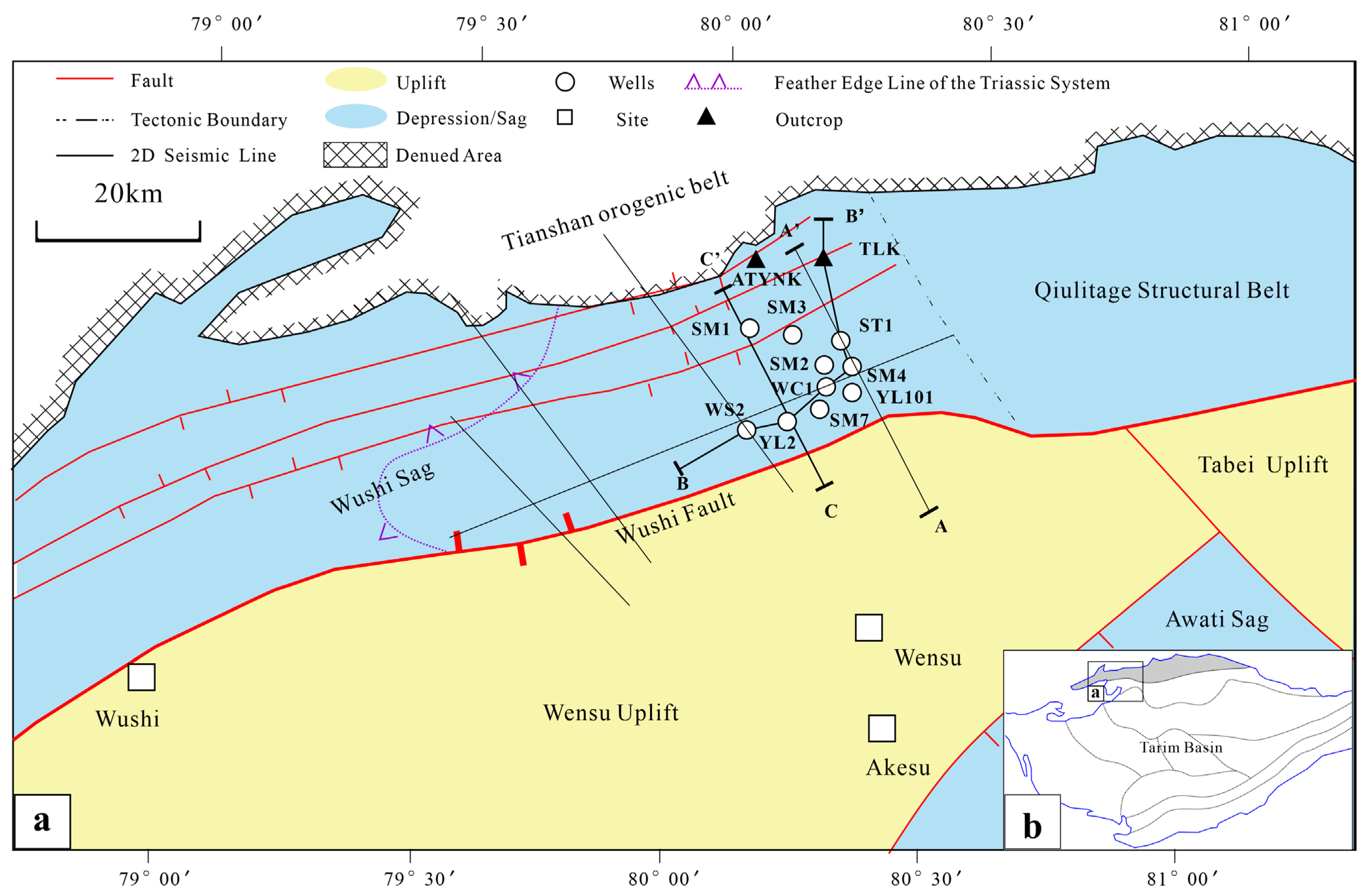
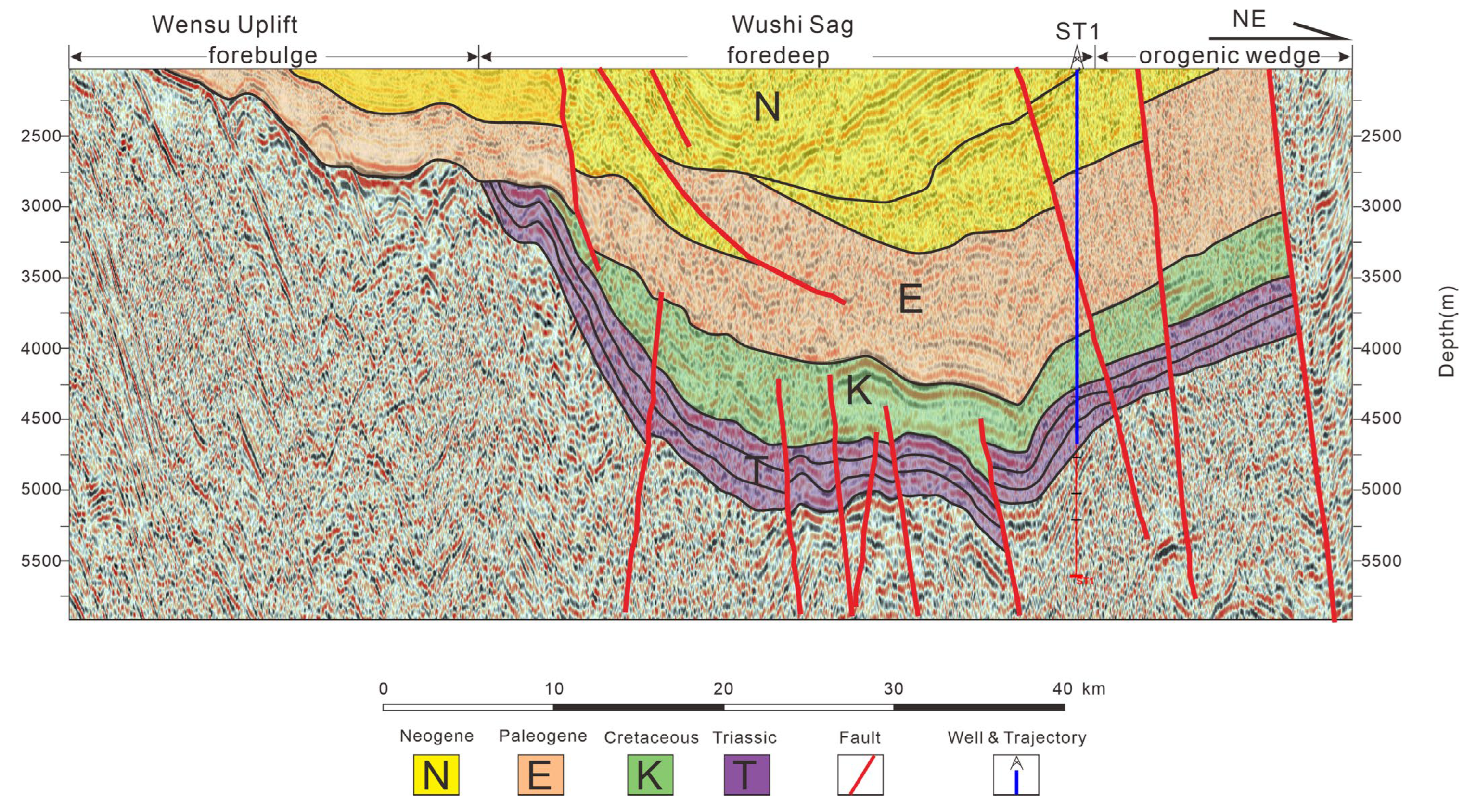
2. Geological Setting

The Kuqa Foreland Basin is situated along the northern margin of the Tarim Basin, adjacent to the Tianshan orogenic belt (Figure 1b). This basin extends approximately northeast–southwest (NEE-trending) over 500 km, with north–south widths ranging from 80 km (maximum) to 30 km (minimum), encompassing an area of approximately 3.7 × 10⁴ km2. Internally, the basin is subdivided into three sags: the Wushi Sag, Baicheng Sag, and Yangxia Sag [39,40].
The Kuqa foreland thrust belt underwent polyphase tectonic evolution. Closure of the South Tianshan Ocean during the Late Permian–Early Triassic transition exerted fundamental control on the development of Late Carboniferous–Indosinian nappe structures [39,40]. Late Cretaceous regional isostatic adjustment provoked extensive uplift, accompanied by virtually complete denudation of Upper Cretaceous sedimentary units [41,42]. Paleocene tectonism manifested as post-collisional crustal reorganization under a weak extensional regime. Neogene–Quaternary continental collision between the Eurasian and Indian plates drove pronounced uplift of the South Tianshan orogen, generating intense thrust propagation that ultimately shaped the current structural architecture [43,44,45].
The study area, the Wushi Sag, constitutes the western sector of the Kuqa Foreland Depression—a NE–SW-trending subsiding depression bounded by distinct structural units (Figure 1a) [40,41,42]. Its northern margin abuts the Tianshan orogenic belt along thrust faults, while the Wushi Fault demarcates its southern boundary against the Wensu Uplift. Eastward, it transitions into the Qiulitage structural belt. Seismic profiles traversing its central domain reveal a classic foreland basin architecture, with south–north transitions from forebulge to foredeep to orogenic wedge domains (Figure 2).
Overlying the Carboniferous basement, the Triassic succession in the Wushi Sag exhibits thickness variations ranging from 430 m along the southern margin to 1550 m in foredeep exposures, displaying an overall northward-thickening wedge geometry (Figure 2). Based on well data and outcrop observations, the Cretaceous sequence is largely absent across most of the sag. The Triassic stratigraphy comprises, in ascending order: the Lower Triassic Ehuobulake Formation (250–240 Ma); Middle Triassic Kelamayi Formation (240–230 Ma); and Upper Triassic Huangshanjie Formation (230–190 Ma) (Figure 3) [43,44,45]. Unconformably overlying Carboniferous limestone, the Ehuobulake Formation features two repetitive cycles, each alternating between greenish-gray mudstone–sandstone intervals and purplish-red sandstone–conglomerate interbeds with mudstone, capped by basal purplish-red conglomerates. The Kelamayi Formation is characterized by rhythmic alternations of pebbly sandstones and variegated (purplish-red to greenish-gray) mudstones with marked lateral thickness variations. The Huangshanjie Formation contains two fining-upward cycles transitioning from basal massive sandstones upward into carbonaceous mudstones and gray-black shales, reflecting progressive waning of sedimentary energy during Late Triassic lacustrine-dominated basin filling (Figure 3).

3. Materials and Methods
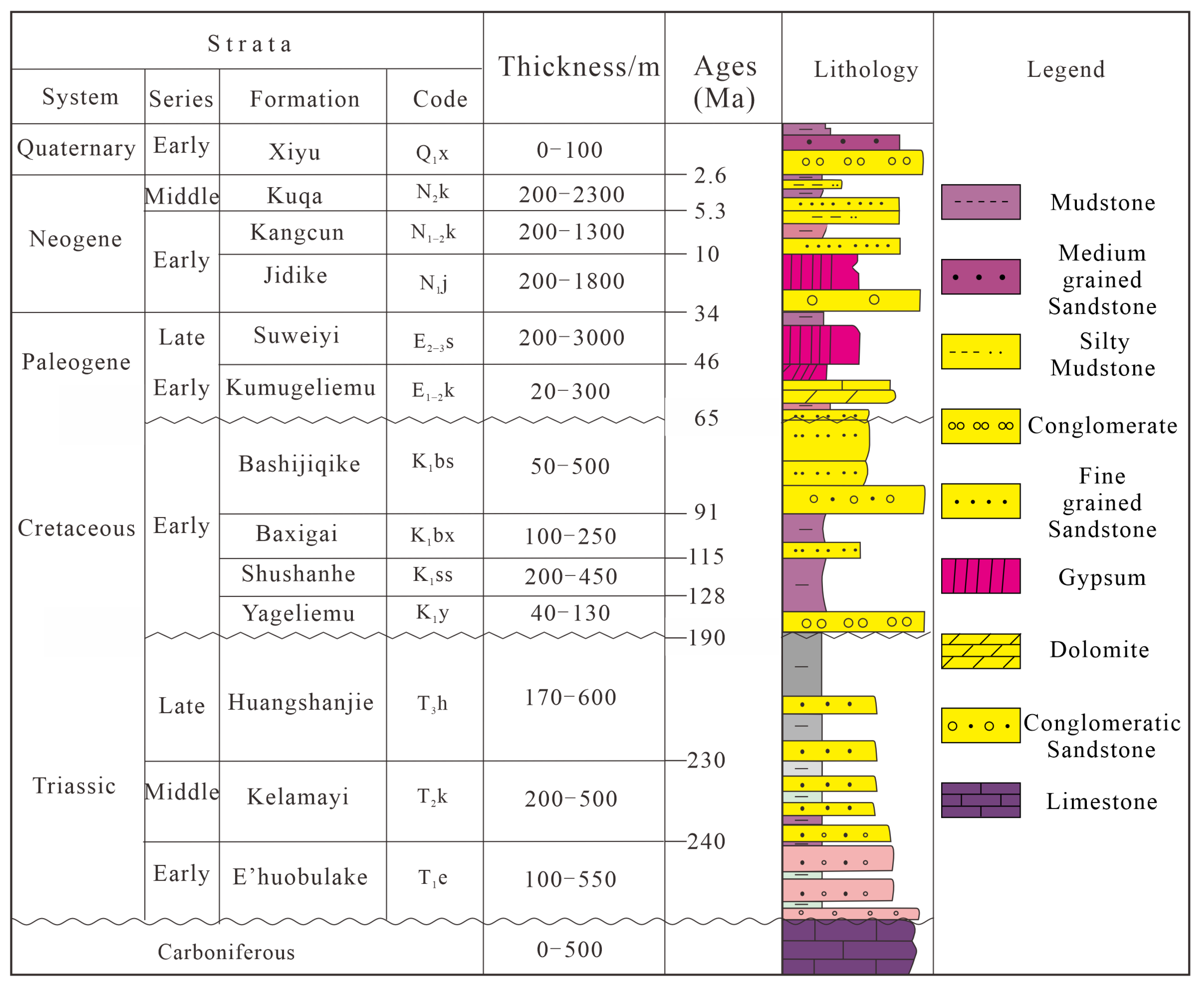
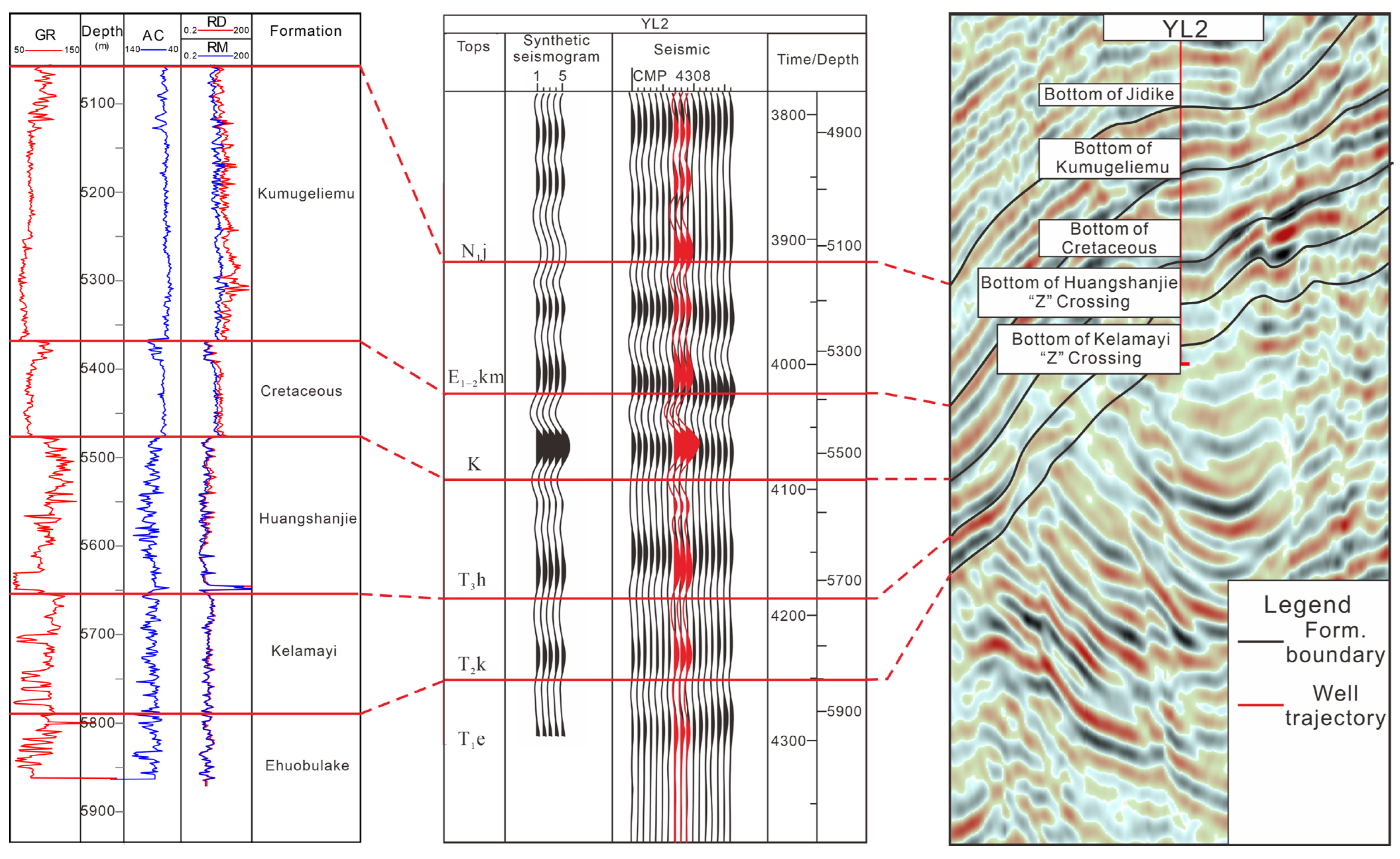
3.1. Materials

This study centers on the Wushi Sag, utilizing integrated multi-source datasets encompassing well logs (predominantly resistivity RD and gamma-ray GR curves) and mud logging records from ten southern boreholes—ShenMu-1 (SM1), ShenMu-2 (SM2), ShenMu-3 (SM3), ShenMu-4 (SM4), ShenMu-7 (SM7), SuTan-1 (ST1), YiLa-2 (YL2), YiLa-101 (YL101), Wucan-1 (WC1), and WuShi-2 (WS2)—among which five wells provided critical interpreted intervals (WS2: 428.5 m; YL2: 400 m; WC1: 348 m; SM4: 119 m; ST1: 706 m). The database incorporates six 2D seismic lines (cumulative coverage ~287 km), systematic core descriptions from three cored wells (cumulative length ~36 m) emphasizing lithological characterization and sedimentary structure identification, supported by ~200 high-resolution core photographs. To establish comprehensive northern depositional context, detailed stratigraphic documentation was conducted at the A Tuo Yi Na Ke (ATYNK) and Ta La Ke (TLK) piedmont outcrops, supplemented by ~100 field photographs. These datasets were synthesized through facies analysis protocols, wherein core documentation enabled high-resolution temporal feature reconstruction, well logs constrained vertical lithofacies successions, outcrop observations revealed basin-scale lithologic configurations, and seismic interpretations facilitated regional framework development. Cast thin sections prepared from core samples at Yangtze University laboratories provided pore architecture characterization. Ultimately, synergistic data integration systematically reconstructed Middle–Upper Triassic depositional environments, significantly advancing the understanding of spatiotemporal lithofacies distributions and sedimentary system evolution within the Wushi Sag.

3.2. Methods

This study systematically delineated key stratigraphic boundaries within the Triassic succession using the GeoEast software platform (v3.5.2, National Engineering Research Center of Oil & Gas Exploration Software, CNPC, Beijing, China). The interpreted horizons include the base of the Ehuobulake Formation (T1eh), Kelamayi Formation (T2k), Huangshanjie Formation (T3h), and the Cretaceous (K). The base of the Ehuobulake Formation was identified based on an onlap relationship between the Triassic and underlying strata, while the remaining boundaries were constrained through integrated seismic-geological calibration of a 2D profile intersecting the YL2 well (Figure 4). These horizons established the Triassic stratigraphic framework. Grounded in seismic sedimentology principles, depositional systems were classified through seismic facies analysis [46,47,48]. To address interpretational ambiguities in specific seismic facies (e.g., SF2, where fan-delta plains and braided-river delta plains exhibit similar seismic reflections), this study integrated outcrop observations, core sedimentology, and seismic characteristics to achieve precise genetic interpretation. Ultimately, synthesis of seismic facies and depositional facies revealed three-dimensional spatial distribution patterns of Triassic depositional systems.
Based on the paleotopographic restoration scheme proposed by Jiang [49], the pre-Triassic basement relief was reconstructed using Move™ software (Midland Valley Exploration Ltd., Glasgow, UK; version: 2018.1.0), leveraging interpreted intra-Triassic features from multiple 2D seismic lines acquired in the study area. Structural measurements of outcrop characteristics—including vertical erosional truncations, ripple crest orientations, and cross-bedding azimuths—were acquired through field geological compass surveys. Paleocurrent directions were statistically quantified via rose diagram construction, elucidating predominant sediment transport pathways during Triassic deposition [50,51,52]. This methodology establishes robust constraints on the interplay between inherited paleotopography and syndepositional sedimentary dynamics, providing critical insights into basin-margin provenance systems and axial drainage patterns.
The observation and identification of rock thin sections were conducted using a Leica DM4P semi-automated upright polarizing microscope (Leica Microsystems, Wetzlar, Germany) at the Laboratory Center of the School of Earth Sciences, Yangtze University. This analytical method was employed to determine the reservoir characteristics of the Triassic strata within the study area.

4. Results

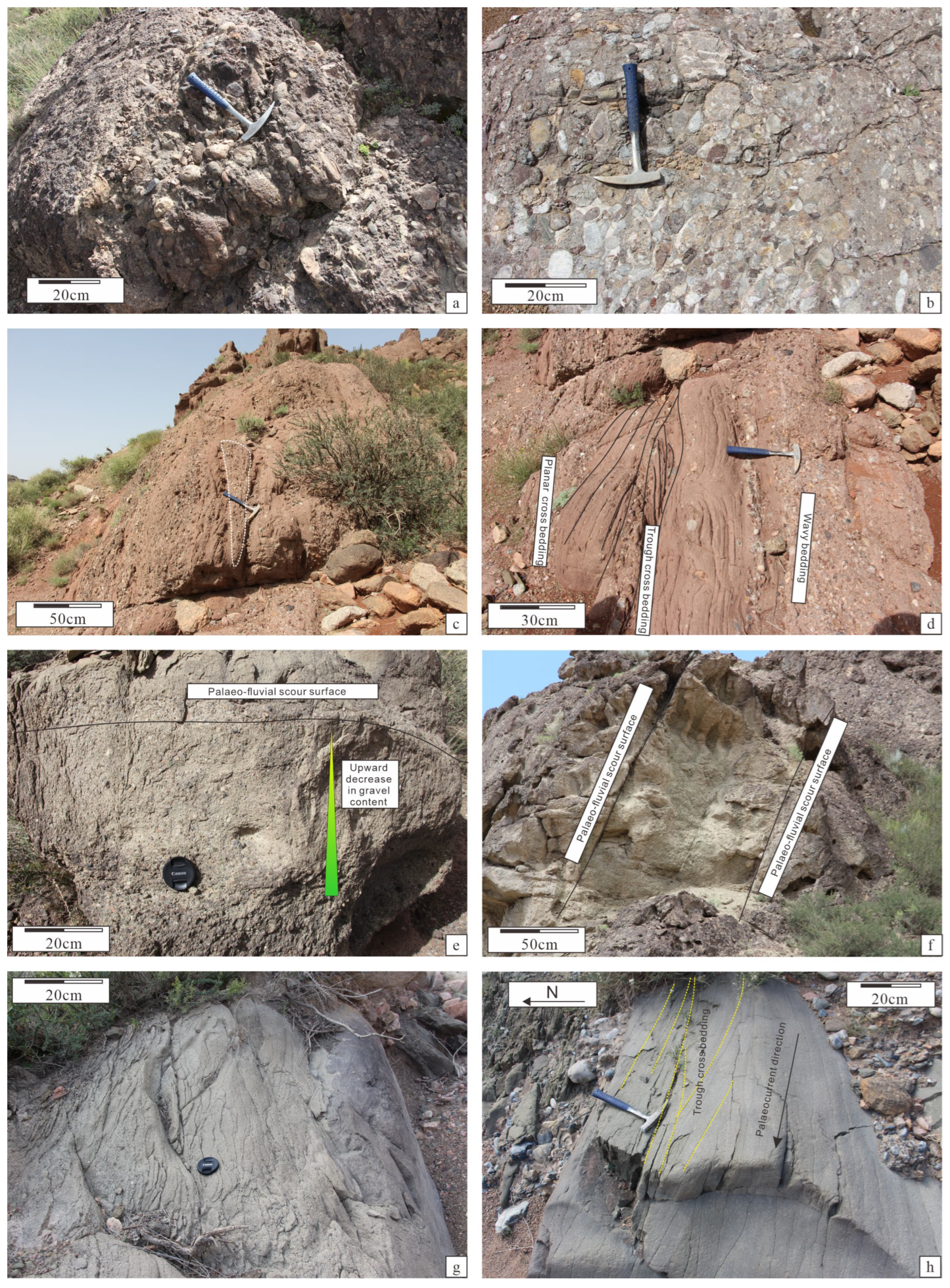
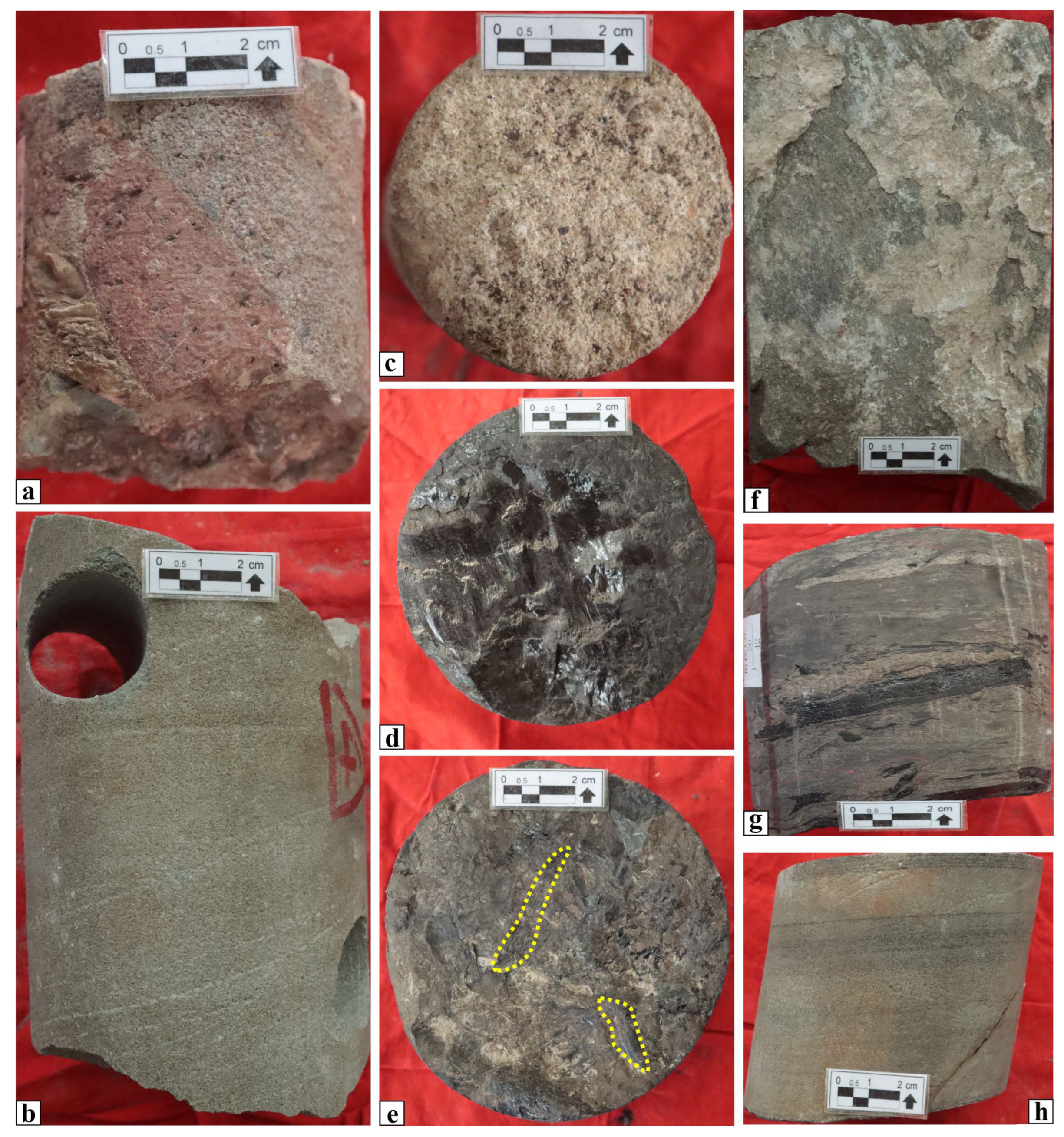
4.1. Sedimentary Facies Types and Their Characteristics

4.1.1. Fan-Delta

Fan-delta deposits, diagnostic of tectonically active settings with significant topographic relief, are well-developed within the studied mountain-front outcrop sections (ATYNK, TLK). Sedimentary characteristics reveal that the fan-delta plain subfacies is predominantly composed of thickly bedded, massive conglomerates and pebbly coarse sandstones (Figure 5a–c). These deposits exhibit disordered stacking, very poor sorting, and textures ranging from clast-supported to matrix-supported, with sporadic intercalated lenses of collapse breccia (Figure 5c). A diverse suite of sedimentary structures includes scour-and-fill structures, massive bedding, and large-scale tabular cross-bedding (Figure 5d,h). Vertical sequences display upward-fining retrogradational or upward-coarsening progradational patterns, with individual depositional cycles bounded by abrupt erosional contacts (Figure 5d). This depositional system exhibits pronounced sensitivity to tectonic activity; its spatial distribution and morphology are strictly controlled by fault intensity and paleotopographic gradients, constituting a significant hydrocarbon reservoir unit within the region.
Fan-Delta Plain
The fan-delta plain, representing the subaerial component of the fan-delta system, exhibits sedimentological characteristics indicative of proximal depositional settings. Outcrop analyses reveal dominantly coarse-grained lithologies characterized by poor sorting, subangular to angular clast morphologies, and matrix-supported textures, collectively reflecting low sediment maturity associated with rapid deposition near source areas (Figure 5a–c). This facies domain comprises two principal microfacies: gravel-rich braided channel deposits and interchannel sandstone-mudstone complexes. The braided channel facies constitute the primary coarse sediment transport pathways, dominated by clast-supported conglomerates with crude horizontal stratification and erosional basal contacts. In contrast, the interchannel facies, formed through episodic overbank flooding along channel margins, consists of reddish-brown to maroon mudstones and silty mudstones, often displaying faint laminations or rare bioturbation structures that are indicative of low-energy suspension settling (Figure 5d) [53]. The textural dichotomy between these microfacies highlights the dynamic alternation between high-energy channelized flows and quiescent floodplain sedimentation across the fan-delta plain.
Fan-Delta Front
The fan-delta front, situated within shallow-water environments between the shoreline and normal wave base level, represents a dynamic zone where fluvial processes interact with lacustrine hydrodynamic forces [54,55]. This subaqueous realm can be subdivided into distinct microfacies associations, including subaqueous distributary channels, interdistributary bays, and sheet sand deposits, based on sedimentary architecture and depositional processes. Field investigations in the study area predominantly reveal subaqueous distributary channel deposits, which exhibit comparatively finer grain sizes relative to proximal fan-delta plain facies. These deposits are dominated by gray-yellow to gray medium-grained sandstones (Figure 5e,g), characterized by abrupt channel scours (Figure 5f) and well-developed trough cross-stratification (Figure 5h). The textural maturity of these sandstones reflects enhanced sorting and reworking under combined fluvial and wave energy regimes. The pervasive occurrence of erosional surfaces and unidirectional current structures within channel fills indicates episodic high-energy flow events alternating with phases of sediment bypass or low-energy suspension settling. These sedimentary signatures collectively document the transitional nature of the fan-delta front environment, where river-derived sediments are progressively modified by wave-induced redistribution prior to final deposition.

4.1.2. Braided-River-Delta Depositional System

Braided deltas, formed through the progradation of braided fluvial systems into standing water bodies, are characterized stratigraphically by vertically stacked coarsening-upward sequences [56,57]. Conventionally, these systems are subdivided into three subfacies: delta plain, delta front, and prodelta [58], each representing distinct depositional regimes governed by fluvial-lacustrine interactions.
In the study area, however, sedimentological differentiation is only robustly achievable for the delta plain and delta front subfacies. The prodelta subfacies exhibits ambiguous differentiation from fine-grained littoral-shallow lacustrine deposits due to overlapping textural characteristics, organic matter content, and bedding architectures. This diagnostic challenge arises from comparable hydrodynamic conditions and similar sediment supply mechanisms in low-gradient basin-margin settings. Consequently, all dark-colored fine-grained successions—featuring laminated siltstones, organic-rich mudstones, and sporadic bioturbation structures—are systematically classified as littoral-shallow lacustrine deposits within the current facies framework. This operational categorization prioritizes lithological continuity and practical mapping consistency while acknowledging limitations in resolving subtle depositional energy gradients between prodeltaic and lacustrine environments under the study area’s specific paleogeographic constraints.
Braided-River-Delta Plain
The braided delta plain, comprising braided distributary channels, floodplain mudstone deposits, and alluvial plain facies [59], exhibits extensive development of coarse-grained sand-conglomerates with cumulative thicknesses exceeding tens of meters, interbedded with gray to yellowish-brown mudstone intervals (Figure 6c). This subfacies domain is subdivided into two principal microfacies: braided distributary channel fills and associated floodplain deposits. The braided distributary channels represent the dominant sediment transport pathways, characterized by gray-brown pebbly conglomerates that display prominent clast imbrication and diverse sedimentary structures, including massive bedding, wedge-shaped cross-stratification, and tabular cross-bedding. These channel fills exhibit blocky to serrated log motifs on wireline logs, featuring high amplitude values with minor serration, typically showing gradational upper contacts and abrupt basal boundaries with underlying strata (Figure 7).
Floodplain deposits, widely distributed throughout the study area, consist predominantly of purple to maroon mudstones intercalated with siltstone laminae (Figure 6f). These fine-grained successions are characterized by bell-shaped gamma-ray log responses with elevated values (Figure 7), reflecting progressive fining-upward sequences associated with waning flow energies during overbank flooding events. The significant textural contrast between high-energy channel conglomerates and low-energy floodplain silt-clay sediments underscores the dynamic interplay between channelized flow competence and episodic floodplain inundation within the braided delta plain depositional system.
Braided-River-Delta Front
The braided delta front deposits are predominantly characterized by gray-colored sand-conglomerates with relatively limited depositional scale and finer grain sizes compared to proximal delta plain facies, primarily consisting of sandstones and pebbly sandstones frequently interbedded with black to grayish-black mudstones, while coal seams are rarely observed. This subfacies domain comprises two principal microfacies associations: subaqueous distributary channels and interdistributary bay deposits [60].
Subaqueous distributary channels form the dominant depositional elements within the braided delta front, predominantly composed of medium- to fine-grained sandstones with subordinate siltstones, coarse sandstones, and pebbly sandstones. Vertical lithofacies successions display a fining-upward trend from coarse basal units to finer upper intervals. Wireline log responses typically exhibit blocky, bell-shaped, or composite patterns reflecting these grain size transitions (Figure 7). The channel fills are further characterized by frequent lateral migration and vertical stacking under highly dynamic hydrodynamic conditions, evidenced by multiple internal erosional surfaces and channel-on-channel incision geometries.
Interdistributary bay deposits, in contrast, consist of thinly laminated mudstones and siltstones with rare wave ripples or bioturbation features, representing low-energy suspension settling between active channels (Figure 6g). This architectural complexity underscores the interplay between high-energy fluvial sediment delivery and wave-modification processes within the delta front environment, where recurrent channel avulsion and reworking processes govern the spatial heterogeneity of reservoir-quality sand bodies.

4.1.3. Lacustrine

The division of lacustrine facies zones is primarily based on water depth and sediment position within the lake, categorized into littoral lacustrine, shallow lacustrine, semi-deep lacustrine, and deep lacustrine subfacies [61,62,63]. In the study area, an inland lake basin subjected to an arid climate, frequent lake-level fluctuations have resulted in continuous deposition of littoral-shallow lacustrine subfacies and the previously described prodelta subfacies. These subfacies exhibit overlapping sedimentary characteristics that preclude strict differentiation. Consequently, all fine-grained dark sediments within these environments are uniformly classified as the littoral-shallow lacustrine subfacies in this study.
Littoral-Shallow Lacustrine
The littoral-shallow lacustrine subfacies occupies marginal zones of the lacustrine basin [64,65], positioned proximally to shorelines relative to semi-deep lacustrine environments. This setting receives relatively coarse clastic inputs from adjacent terrestrial sources while experiencing complex hydrodynamic regimes, shallow water depths, and periodic subaerial exposure leading to oxidative alteration. Within the Triassic succession, these deposits are widely developed across multiple stratigraphic intervals, particularly in the Huangshanjie Formation, and are subdivided into mud-dominated and sandbar microfacies based on lithological criteria.
The mud-dominated microfacies accumulates in relatively deeper sectors of this environment, primarily comprising dark gray silty mudstones and laminated mudstones with intermittent thin siltstone interbeds (Figure 6h). These successions exhibit massive bedding textures and localized concentrations of plant-derived carbonaceous fragments. Gamma-ray log responses display serrated linear patterns with elevated values (Figure 7), reflecting intermittent sedimentation under low-energy conditions with limited clastic influx. In contrast, sandbar deposits develop along proximal margins of the littoral-shallow lacustrine zone, characterized by siltstones and argillaceous siltstones organized into coarsening-upward cycles. These deposits record weak hydrodynamic conditions through sedimentary structures including wavy bedding, lenticular lamination, and wave-ripple cross-stratification. Corresponding gamma-ray signatures exhibit serrated bell-shaped motifs (Figure 7), indicative of progressive sediment aggradation under fluctuating energy regimes. The textural and log response contrasts between these subfacies underscore the bathymetric and energy gradients governing sediment distribution within dynamic lacustrine margin environments.
Semi-Deep Lacustrine
The semi-deep lacustrine subfacies occupies bathymetric zones below the wave base level, representing anoxic reducing environments typically situated between the normal wave base and the deepest lacustrine depocenters, forming annular belts along the basin periphery [66,67,68,69]. Dominated by black to grayish-black mudstones (Figure 6d), these deposits exhibit massive bedding structures and millimeter-scale horizontal laminae, often containing dispersed phytodetrital carbonaceous fragments that collectively indicate sedimentation under persistent low-energy, oxygen-depleted conditions.
This subfacies is preferentially developed within the Huangshanjie Formation, where it attains maximum stratigraphic expression in the TLK section with cumulative thicknesses reaching 190 m. The lithological homogeneity and exceptional thickness preservation reflect sustained basinal subsidence coupled with limited clastic influx during deposition. The pervasive anoxia, evidenced by the absence of bioturbation and preservation of delicate organic laminations, underscores the stratification of water columns and limited vertical mixing in these semi-deep lacustrine environments. Spatial thickness variations across the study area correlate with differential subsidence rates and proximity to syndepositional fault systems, with the TLK section’s maximum thickness highlighting its position as a long-lived depocenter during Triassic lacustrine evolution.

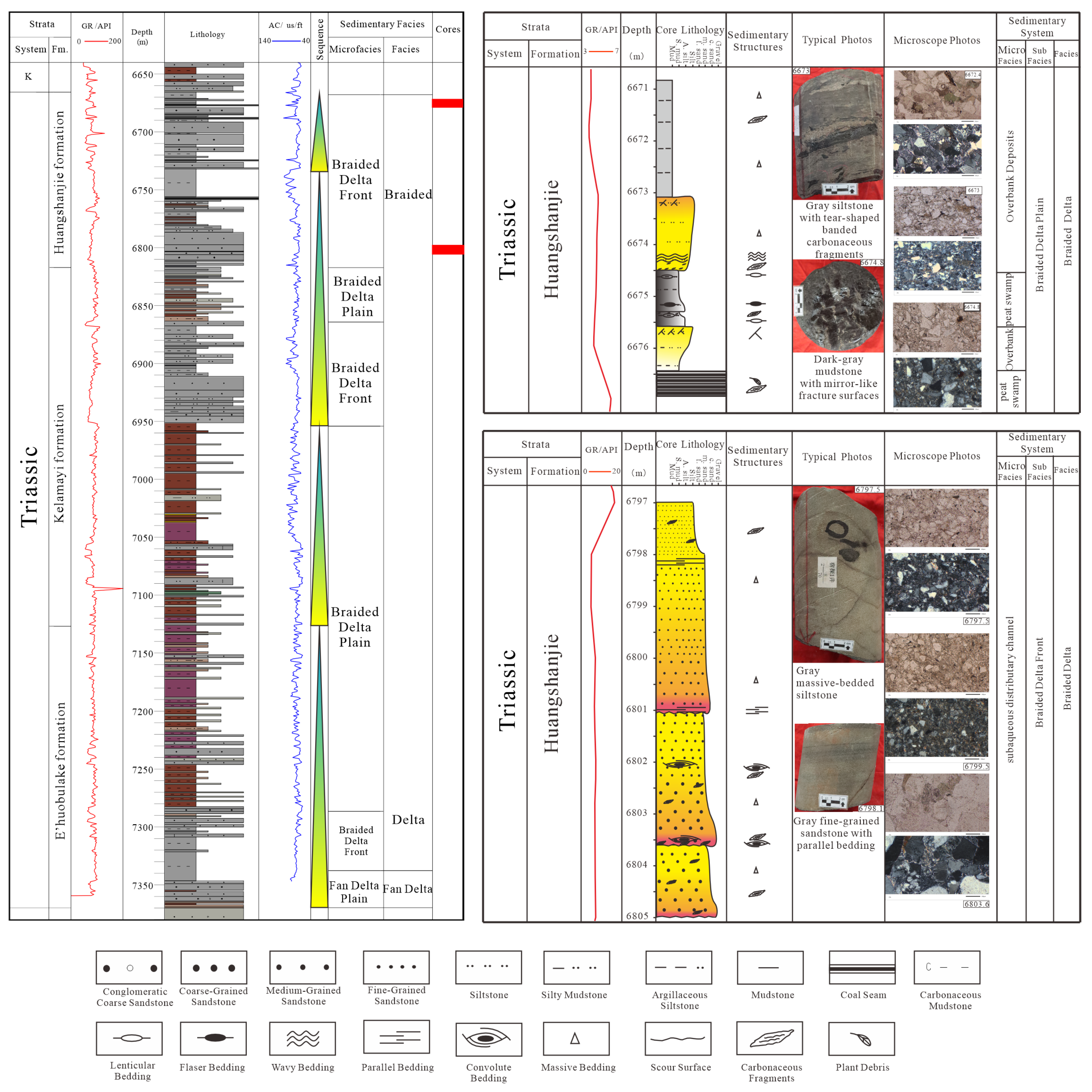
4.2. Spatial Distribution and Evolution of Sedimentary Facies

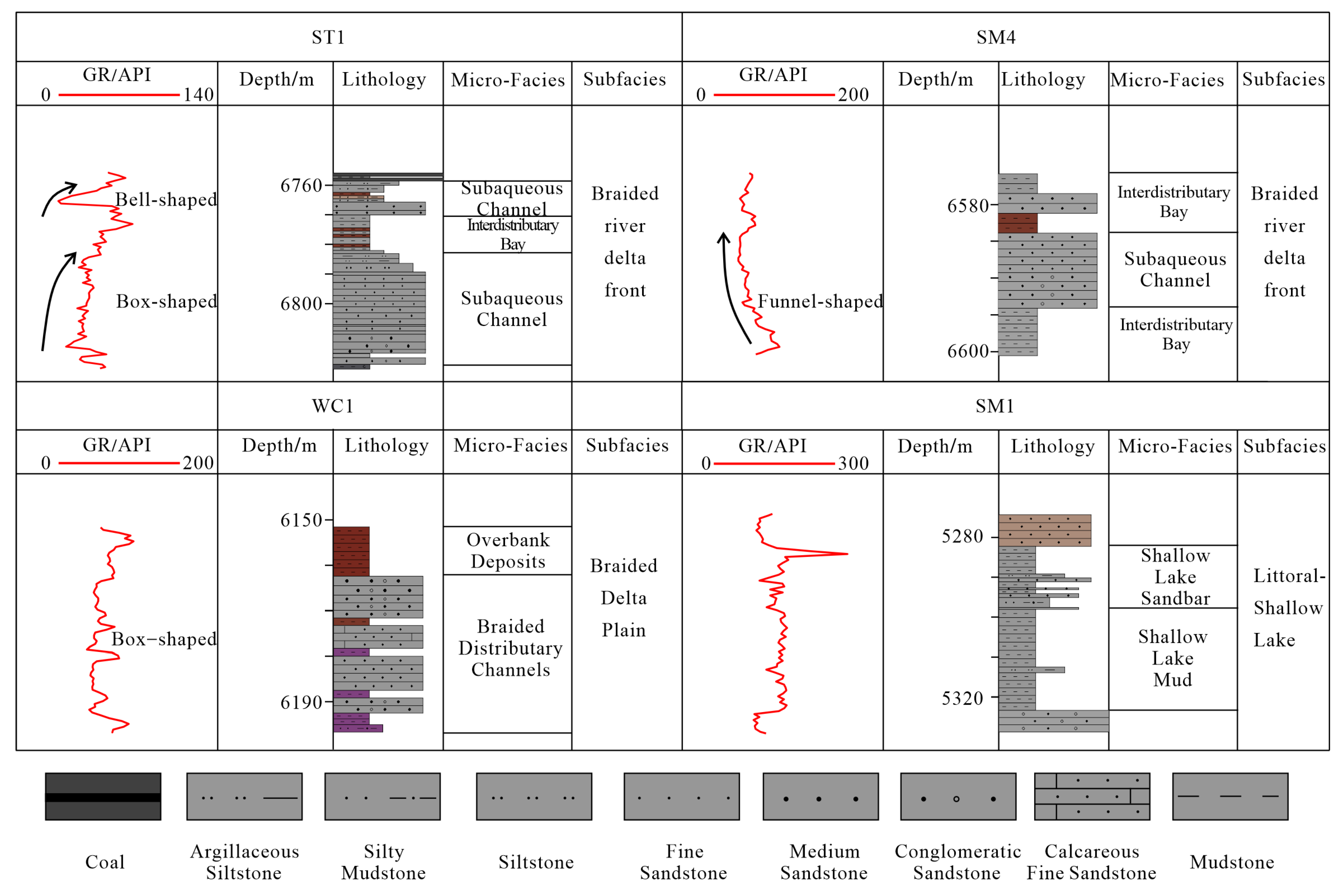
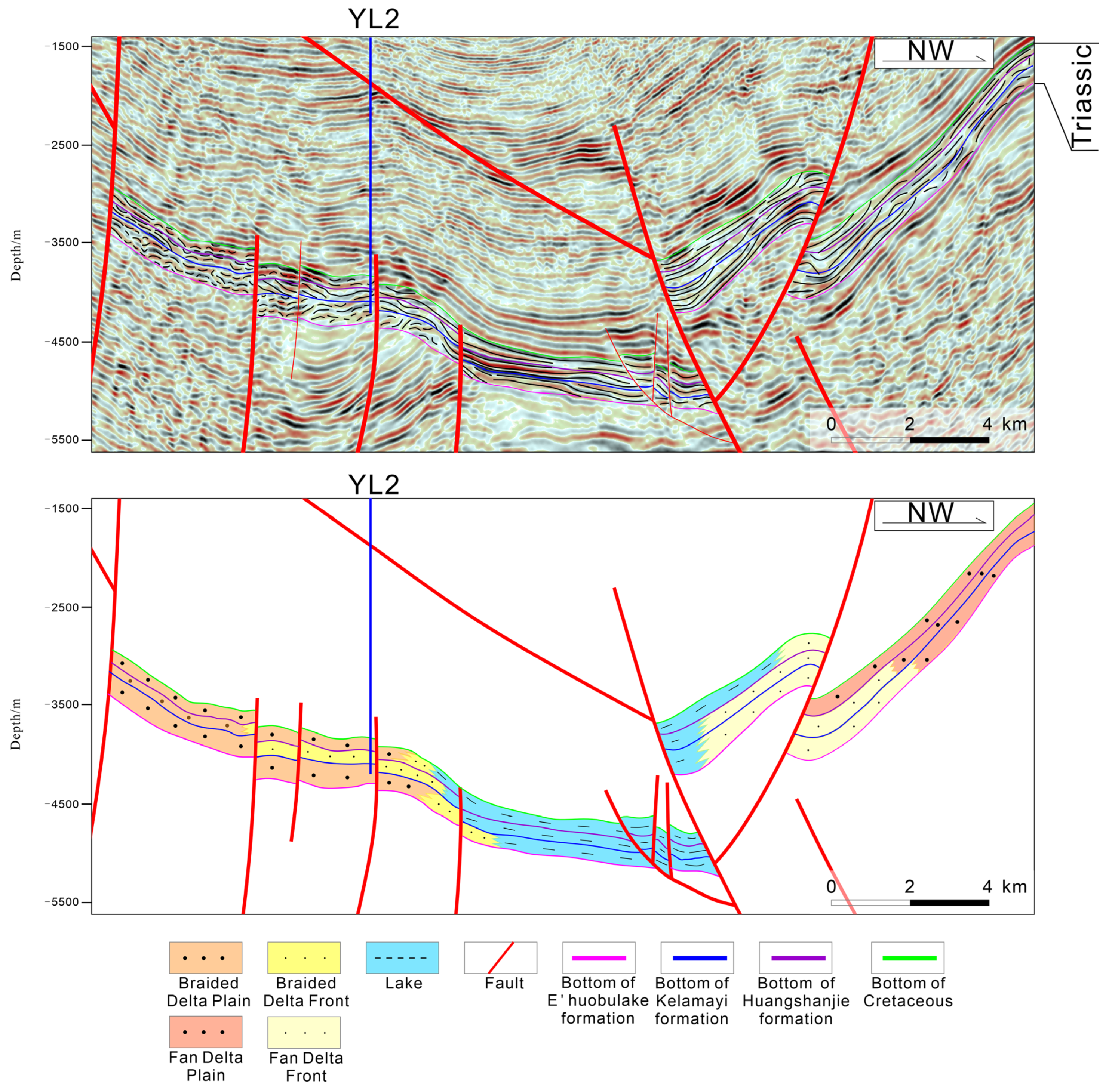
4.2.1. Single-Well Sedimentary Facies Evolution

The stratigraphic architecture and vertical facies evolution of the Triassic succession in the Wushi Depression are exemplified by the ST1 borehole, revealing distinct depositional patterns across the Kelamayi and Huangshanjie formations. Within the Kelamayi Formation, deposition is dominated by braided delta plain and delta front systems. The delta front facies, concentrated in the middle interval, comprises gray fine- to medium-grained sandstones exhibiting gamma-ray (GR) log responses of bell-shaped and box-shaped patterns. The lower interval of the formation is characterized by braided delta plain deposits featuring thick-bedded reddish-brown to brown mudstones, which display notably higher GR values compared to upper plain deposits, reflecting increased clay content and reduced hydrodynamic energy in proximal settings (Figure 8).
The Huangshanjie Formation records two vertically stacked coarsening-to-fining cycles, documenting the transition from braided delta front to lacustrine depositional systems. The lower cycle initiates with thick-bedded medium-grained sandstones of the delta front subfacies, displaying GR log motifs of bell and box shapes. This transitions upward into lacustrine deposits dominated by gray mudstones with intercalated coal seams, marked by elevated GR values and leftward deflection on acoustic logs. The upper cycle exhibits reduced thickness and finer grain sizes, with lacustrine facies containing massive and wavy bedding structures, along with abundant carbonaceous fragments exemplified by dark gray mudstone at 6674.8 m depth (Figure 6d).
Vertical succession analysis demonstrates a basinward deepening trend with progressive hydrodynamic energy attenuation in the ST1 borehole. This evolutionary trajectory reflects a depositional regime shift from terrestrial delta plain–floodplain environments to delta front-lacustrine systems, controlled by base-level fluctuations and sediment supply variations during the Triassic. The facies stacking pattern correlates with episodic delta progradation interrupted by lacustrine transgressive events, as evidenced by cyclic GR log signatures and lithofacies alternations between fluvial-dominated coarse clastics and suspension-settled lacustrine fines.

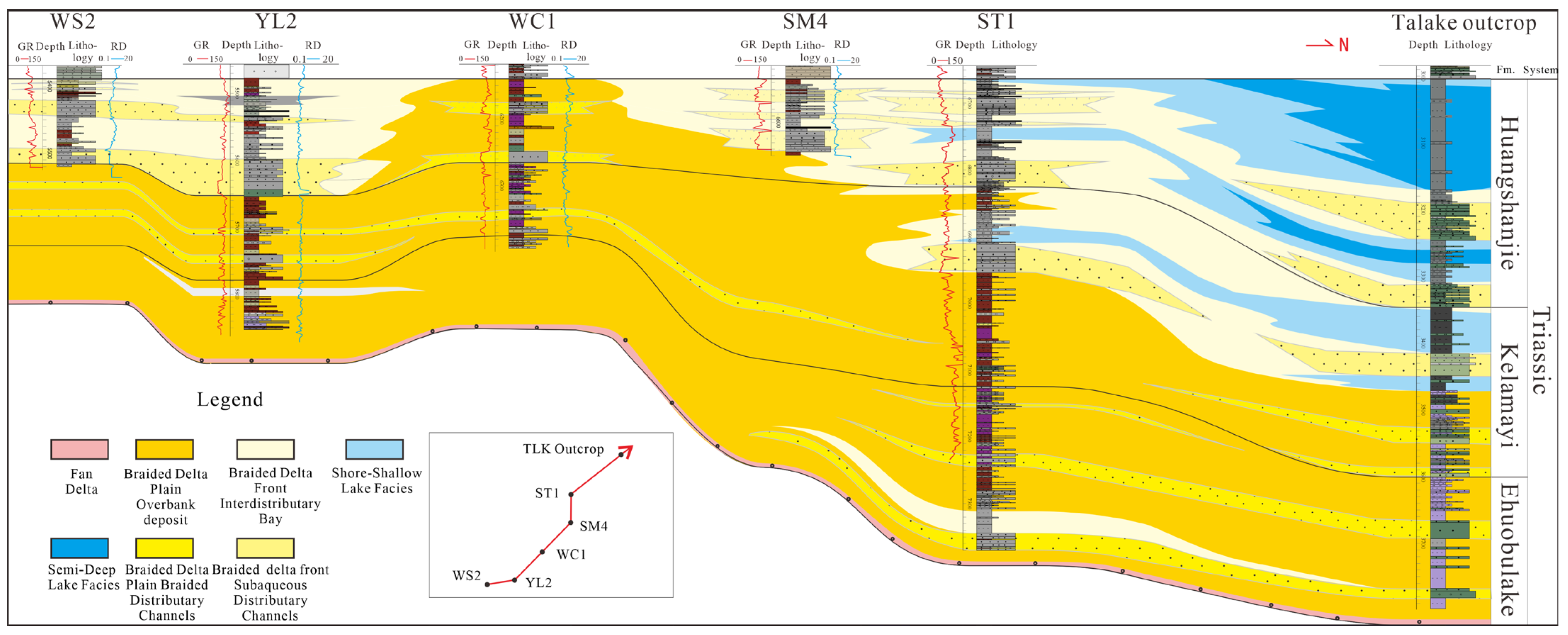
4.2.2. Lateral Evolution of Sedimentary Facies

Building upon single-well microfacies characterization and vertical depositional system evolution, this study employs stratigraphic correlation methodologies to construct regional depositional profiles, elucidating both lateral facies distribution patterns and vertical stacking architecture within the Triassic succession. A representative cross-section oriented perpendicular to the principal sediment transport direction (Figure 9) was established across the central Wushi Depression toward the Tianshan orogenic belt, revealing systematic facies transitions from proximal to distal settings.
During Middle Triassic Kelamayi Formation deposition, lacustrine expansion facilitated distinct spatial differentiation: proximal wells (WS2, YL2, WC1) adjacent to source areas developed thick braided delta plain–floodplain deposits dominated by reddish-brown mudstones with intermittent channel sandstones. The transitional ST1 well records a downstream facies shift, with lower intervals containing delta plain–floodplain facies that grade upward into delta front deposits characterized by distributary channel sandstones, interchannel silts, and thin littoral-shallow lacustrine mudstones.
The distal TLK outcrop exhibits an analogous vertical succession to ST1, though with notable scale differences: while lower Kelamayi Formation intervals contain comparable delta plain–floodplain deposits, upper sections display expanded littoral-shallow lacustrine mudstone packages exceeding 50 m thickness. This thickness disparity indicates TLK’s paleogeographic position closer to the lacustrine depocenter during late Kelamayi deposition, contrasting with ST1’s intermediate position within the delta front to lacustrine transitional zone.
The cross-section demonstrates two key evolutionary trends: (1) laterally, progressive fining and increased lacustrine influence from NE (proximal) to SW (distal) directions, evidenced by decreasing sandstone/mudstone ratios and enhanced organic matter preservation; (2) vertically, episodic delta progradation punctuated by lacustrine transgressive events, recorded through cyclic alternations of channelized conglomerates and laminated lacustrine shales. These patterns collectively document the dynamic interplay between orogenic uplift-driven sediment supply and base-level fluctuations in controlling basin-fill architecture.

4.2.3. Spatial Stacking Patterns of Depositional Facies

Multiple NW-SE trending seismic profiles traversing the central study area elucidate the geological architecture of the Wushi Depression (Figure 2 and Figure 10). As exemplified by Profile YL2 (Figure 10), a pronounced uplift zone developed in the southern sector exhibits >2000-m topographic relief relative to the northern foredeep sag, collectively constituting a characteristic asymmetric wedge structure diagnostic of foreland basins. The Triassic System demonstrates systematic northward-thickening strata with internal seismic reflections characterized by low-to-moderate amplitude (8–15 Hz frequency bandwidth) and diverse reflection configurations. Integrated seismic facies analysis of well-constrained 2D profiles, corroborated by borehole-derived sedimentary facies and outcrop interpretations, establishes a robust seismic-to-sedimentary facies correlation framework (Table 1). Synthesized evidence reveals a definitive sedimentary evolutionary progression within the Triassic vertical succession: braided fluvial-delta and fan-delta deposits transition upward into lacustrine facies assemblages. This depositional regime shift directly responds to sustained Triassic thrust-compression within the South Tianshan orogenic belt—increased tectonic loading enhanced lithospheric flexure, driving basin morphological evolution from a broad, shallow depression during the Ehuobulake Formation depositional period to a narrow, deep foredeep configuration by the Huangshanjie Formation depositional stage.

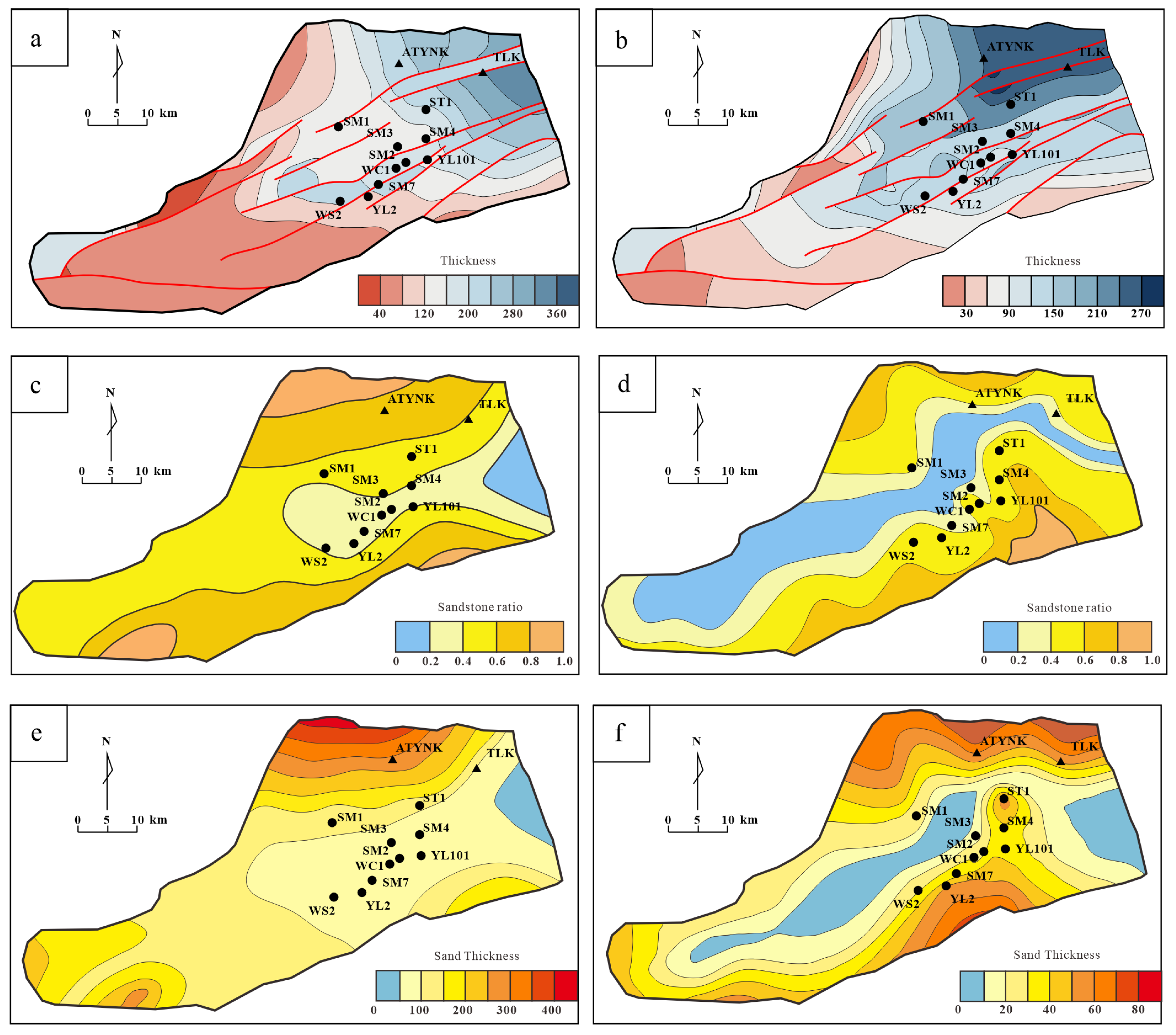
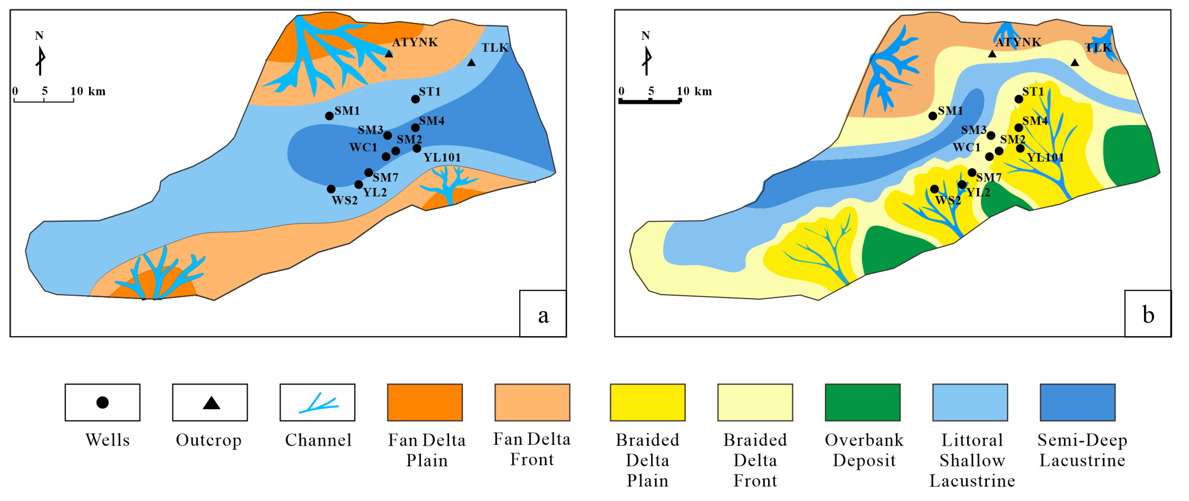
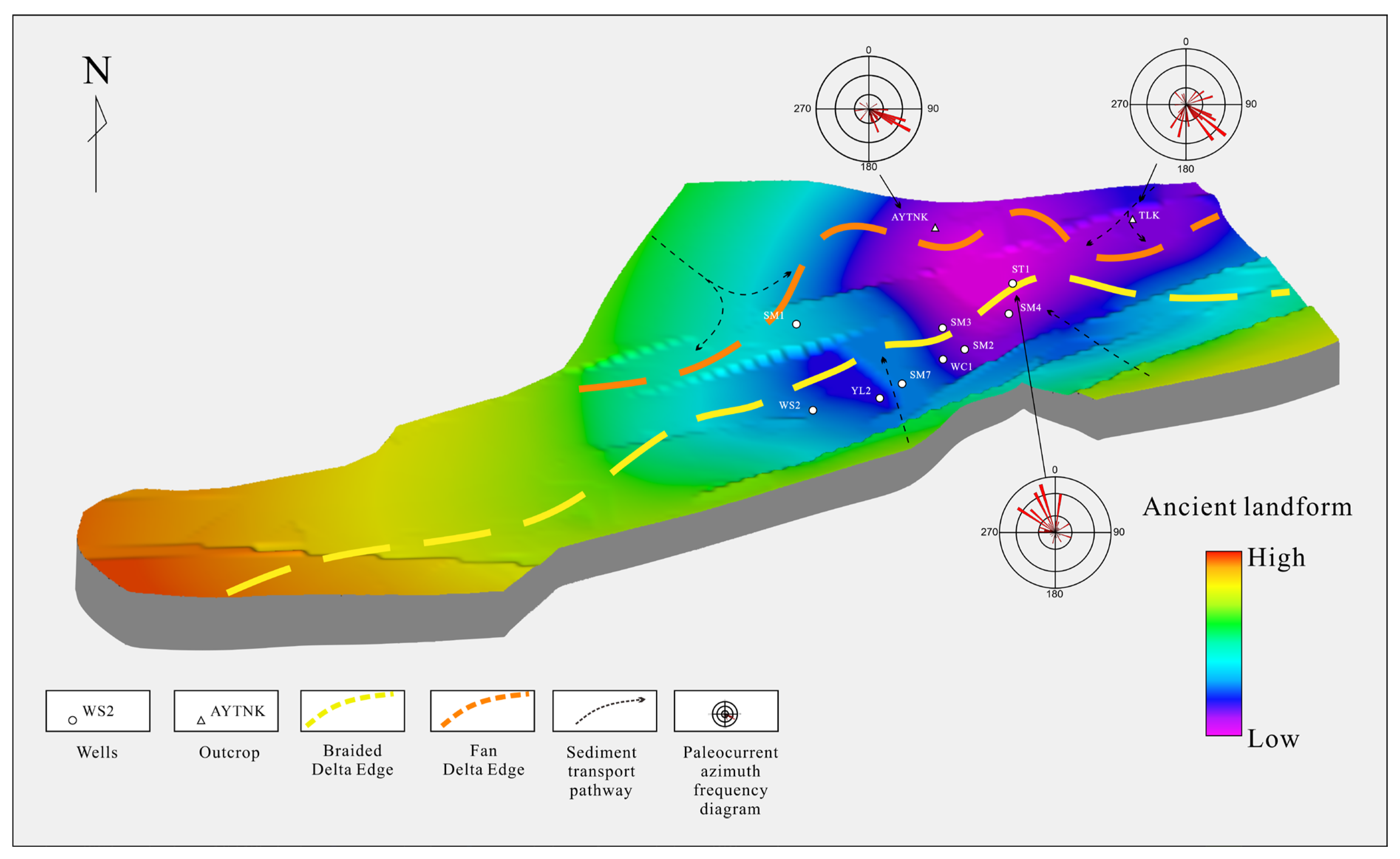
4.2.4. Planar Distribution Characteristics of Sedimentary Facies

Integrating borehole data analysis with depositional facies correlations from multiple well profiles, this study employs a multifactorial mapping approach constrained by parameters including single-well conglomerate thickness and sand-to-shale ratios to reconstruct the spatial distribution of sandstone thickness, formation thickness, and sand/shale ratios for the Kelamayi and Huangshanjie formations in the Wushi Depression (Figure 11). These quantitative datasets form the basis for compiling depositional paleogeographic reconstructions (Figure 12), revealing temporal and spatial variations in sedimentary systems.
During the deposition of the Kelamayi Formation, the Wushi Depression was a vast, low-slope foreland basin primarily controlled by two sediment dispersal pathways: a dominant northern axial source and a secondary southern lateral source. Petrological and thickness distribution patterns indicate that the northern sediment source dominated during this period, delivering proximal fan-delta sediments from the rapidly eroding Tianshan orogenic belt. The resulting sedimentary systems transitioned from interconnected alluvial fans to shallow lacustrine environments distally, with sand body geometries exhibiting southeastward progradation.
The Huangshanjie Formation records the reorganization of paleogeographic framework due to intensified north–south compression within the foreland basin. Enhanced tectonic subsidence and accelerated mountain uplift increased sediment flux, generating two primary characteristics: (1) expanded distribution of finer-grained sediments; and (2) the development of zoned basin architecture. The northern basin domain features fan-delta systems characterized by thick conglomeratic deposits, while the southern region evolved into a braided-river-delta environment dominated by thick successions of medium to fine sandstones. This bimodal sedimentary differentiation reflects spatial variations in subsidence rates along basin margins and differential thrust belt activities.

5. Discussion

5.1. Tectonic Controls on Depositional Systems

5.1.1. Paleogeomorphologic Framework Prior to Triassic Deposition: Controls on Facies Distribution

A comprehensive analysis of paleogeography, sedimentary facies, and paleocurrent patterns indicates that the Triassic paleotopography fundamentally controlled the spatial distribution of deltaic sedimentary systems in the study area (Figure 13). The basin exhibited an asymmetrical configuration characterized by elevated western regions and lower eastern sectors, with the sedimentary depocenter located among the AYTNK outcrop area, TLK outcrop area, and ST1 well. This topographic framework governed sediment dispersal pathways, enabling detrital materials derived from the North Tianshan Orogen and South Wensu Uplift to be transported through fault overlap zones, fault adjustment zones, and gully systems.
The pronounced paleotopographic slope facilitated rapid sediment accumulation on proximal slopes, establishing distinct lithofacies zones: the northern sector adjacent to steep fault-controlled escarpments developed fan-delta systems, while the gentler southern slopes hosted braided delta complexes with extensive sandy delta front deposits. Northern provenance sediments exhibited significantly shorter transport durations, as evidenced by conglomerates with poor sorting and angular clast morphologies. This contrasts sharply with southern braided delta sediments characterized by moderate sorting and sub-rounded grains. This lithofacies dichotomy underscores how paleotopography-induced energy gradients partitioned sedimentary processes across the basin—the steeper northern margin promoted fan-delta front progradation dominated by debris flows, whereas wave-modification reworked the southern braided delta system within transitional lakeshore zones.

5.1.2. Foreland Tectonic Controls on Syn-Triassic Deposition

Previous research on the Kuqa Foreland Basin indicates that the primary factors governing the depositional systems during the Triassic were basement paleogeomorphology (itself shaped by tectonic activity), sediment supply, and paleoclimate [70]. Climatic conditions influenced the types of sedimentary facies developed, while the interplay between tectonic subsidence and sediment influx directly controlled the spatial configuration of these systems. The evolution of the paleotectonic framework constrained sedimentary evolution, with parameters including thrust loading, sedimentary loading, crustal rheological properties, and intra-crustal forces directly governing lithospheric flexural subsidence. During deposition of the Triassic Ehuobulake Formation to Huangshanjie Formation, sustained compressional forces from the South Tianshan orogenic belt intensified lithospheric flexural deformation, driving basin morphological evolution from a broad-shallow to narrow-deep configuration. This lithospheric flexural variation dictated vertical sedimentary infilling patterns. Within the study area, the vertical succession from Ehuobulake to Huangshanjie formations exhibits an upward transition from braided-river-delta facies to lacustrine facies, reflecting progressive intensification of compressional stress in the foreland basin.

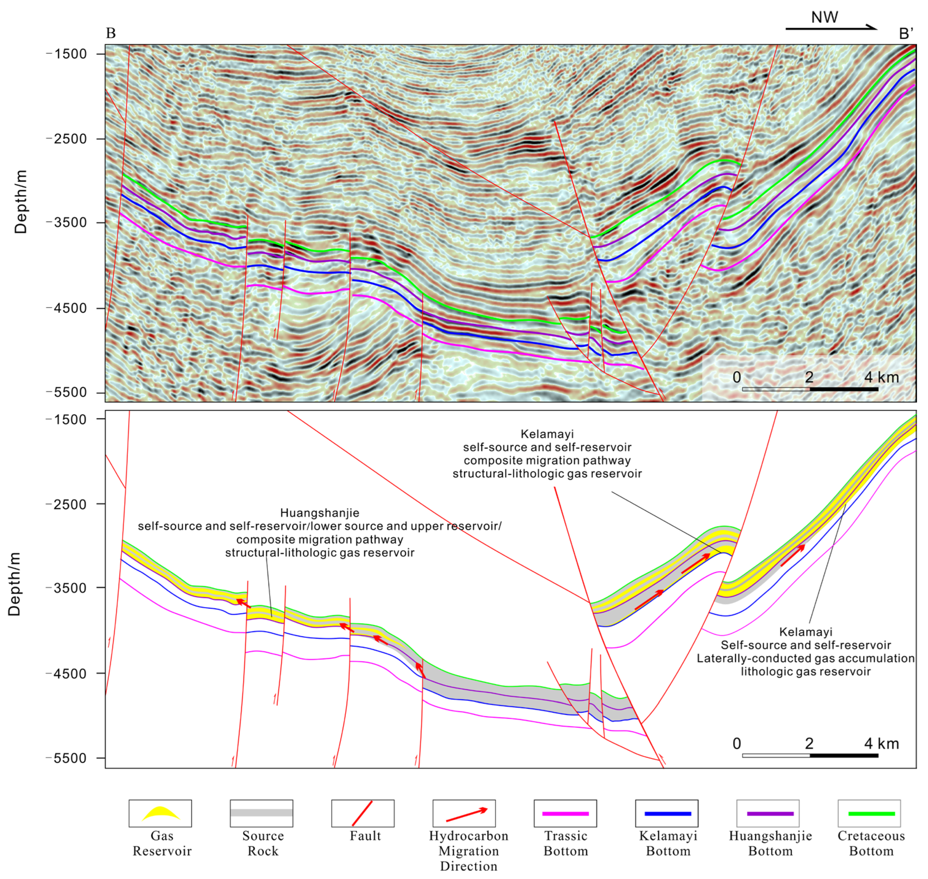
5.2. Petroleum-Geological Implications

Integrated analysis of lithological characteristics derived from multiple boreholes, outcrops, and seismic interpretations reveals two predominant reservoir assemblages within the Huangshanjie and Kelamayi formations in the study area. Regional studies confirm substantial hydrocarbon generation potential for the Triassic lacustrine source rocks in the Kuqa Depression, characterized by high organic carbon enrichment, suitable thermal maturity, and extensive distribution, providing an ample material foundation for large-to-medium gas accumulations [71,72,73,74,75].
Reservoir analysis indicates that the Huangshanjie Formation in the southern study area exhibits diverse pore systems, including dissolution pores, intergranular pores, and structural fractures observed in borehole thin sections. Significant lateral heterogeneity exists within this unit: Well YL2 in the south displays well-developed dissolution and intergranular pores with apparent porosity reaching 10%. Progressing northward to Wells ST1 and SM1, intensified calcareous cementation reduces pore volume substantially, shifting pore types toward predominantly structural fractures. This spatial variation partially reflects burial depth controls on reservoir quality. Overall, Triassic sand bodies exhibit adequate reservoir capacity, qualifying as targets for substantial hydrocarbon accumulations. Core analyses from Well ST1 reveal severe calcite cementation (Figure 14d), with effervescent calcite veins upon hydrochloric acid application visible in core samples (Figure 6f), suggesting that deep central foreland reservoirs may be compromised by high-salinity fluids resulting in inferior reservoir properties.
Sedimentary analysis by Wang Zhenghe et al. of the central Kuqa Depression demonstrates that the coarse-grained conglomeratic units (clast diameter > 10 cm) developed in Members 1 and 3 of the Huangshanjie Formation directly overlie thick, dark mudstones [39]. This abrupt shift to coarse sedimentation responds to a dramatic increase in basin-mountain relief driven by Indosinian tectonic uplift in the provenance area. Conversely, the sharp lithological transition at the top of Member 1/3 to fine-grained deposits (particularly the transition from Member 1 to the dark shale of Member 2) records a rapid lake-level rise triggered by regional lacustrine transgression. This depositional sequence led to the widespread sealing of the early high-porosity and permeability conglomeratic bodies by overlying dense, fine-grained sediments. Consequently, a vertically coupled system formed, comprising the underlying conglomerate reservoir and the overlying mudstone/shale seal. This configuration constitutes an efficient hydrocarbon accumulation unit integrating source rock, reservoir, and caprock, establishing the critical structural foundation for hydrocarbon enrichment within this stratigraphic interval. The Huangshanjie Formation in this study area exhibits analogous sedimentary characteristics, indicating its potential as a similarly efficient accumulation unit capable of hosting large-scale hydrocarbon reservoirs.
Research by Zheng Min et al. on the structural styles and their control on hydrocarbons in the Wushi Sag, utilizing geochemical evidence, identified that the hydrocarbons in the Cretaceous reservoir of Well WC1 originated from lateral migration of underlying Mesozoic source rocks [76]. Integrating seismic profiles and seismic facies interpretations from this study (Figure 10), hydrocarbons generated from the lacustrine source rocks in the Huangshanjie Formation can migrate laterally via fault systems into the reservoir units of the Kelamayi Formation. Analysis of sedimentary facies from connected wells indicates that the extensively developed, laterally continuous continental mudstone layers within the Kelamayi Formation serve as a competent regional seal. Therefore, hydrocarbons are likely to migrate laterally from the Huangshanjie source rocks in the central Wushi Sag to the sandstone reservoirs of the Kelamayi Formation along the sag margins, accumulating to form stratigraphic traps. Additionally, the thrust fault structures along the southern margin of the study area can create small-scale structural-lithological composite traps, as evidenced by the spatial coincidence of seismic amplitude anomalies and fault termination points (Figure 15). These two dominant source–reservoir-seal assemblages provide crucial insights for formulating exploration strategies in foreland basins characterized by complex source–reservoir configurations.

5.3. Comparison with Previous Studies and Novelty of This Study

Prior research on the Wushi Sag has yielded several key findings: Zhao Libin et al. confirmed through carbon isotopic geochemical analysis that hydrocarbon progenitors of Cretaceous oil reservoirs originated from Triassic Huangshanjie Formation source rocks along the sag’s northern margin, identifying two distinct hydrocarbon generation episodes during the Cretaceous and Early Neogene. A consensus exists regarding favorable geological conditions for stratigraphic trap formation within the sag [77]. Concerning Triassic depositional facies distribution, Ji Lidan proposed a dual-provenance model (braided-river-delta in the north, fan delta in the south) [35], while Zheng Chao et al. documented a southeastern fan-delta provenance system for the Ehuobulake Formation in the eastern Yakela Fault Uplift [78]. However, constrained by limited outcrop data from the northern Kuqa Depression and sparse drilling in its central sector, most studies advocate single northern provenance dominance [36,37,79]. Additionally, previous work established that internal fault systems serve as critical migration pathways for Cretaceous hydrocarbon accumulations [77].
This study achieves significant advances through an integrated analysis of northern outcrops, newly acquired drilling and logging data from Well ST1, and high-resolution 2D seismic profiles: (1) We systematically delineate the spatial distribution of the Triassic Kelamayi and Huangshanjie formations, revealing a lateral facies transition from fan-delta facies at the northern ATYNK section to lacustrine facies at the eastern Talak section, evolving into braided-river-delta facies north of Well ST1. Balanced cross-section reconstruction based on seismic data elucidates pre-Triassic paleotopography, providing critical constraints for foreland basin evolution. (2) We identify two reservoir assemblage models (stratigraphic and structural-stratigraphic composite traps) within the Triassic succession. Epoxy-impregnated thin-section analyses confirm a triple-pore system comprising primary pores, dissolution pores, and tectonic fractures. Integrating source rock and seal studies, we demonstrate favorable reservoir conditions and effective hydrocarbon play element matching for substantial accumulation potential. (3) Our study reveals a dual-control mechanism of tectonic activity on depositional evolution: pre-Triassic basement paleotopography governs N-S depositional facies differentiation, while syndepositional foreland tectonism—driven by North Tianshan provenance retreat and southern uplift—triggered lacustrine basin expansion, southward progradation of braided-river-delta systems, and concomitant retreat of northern fan deltas. These findings provide geological foundations for Triassic hydrocarbon exploration and elucidate spatiotemporal controls of tectonic-sedimentary coupling on reservoir development in foreland basins.

6. Conclusions

(1)
Integrated analysis demonstrates that the Triassic succession in the Wushi Sag comprises fan-delta, braided-river-delta, and lacustrine depositional systems exhibiting pronounced spatial differentiation. Northern foreland outcrops are characterized by fan-delta to lacustrine assemblages, whereas braided-river delta systems dominate the southern sector. From the Kelamayi to Huangshanjie formations, progressive retreat of northern fan deltas accompanied sustained northward progradation of braided-river deltas, culminating in maximum lacustrine expansion during Huangshanjie deposition, reflecting stage-specific configurations of sedimentary architecture.
(2)
Spatiotemporal distribution of these depositional systems is governed by multifactorial controls—tectonic activity, sediment supply, and paleoclimate—with tectonics exerting primary influence. Pre-Triassic paleotopography established preferential sediment dispersal conduits that dictated initial depositional patterns, while syndepositional foreland tectonism triggered provenance uplift and basinal subsidence. This dynamic regime drove persistent northward migration of depositional centers and expansion of lacustrine domains, ultimately defining the basin-fill framework.
(3)
Systematic evaluation of source rock potential, reservoir properties, source–reservoir configurations, and migration pathways reveals that hydrocarbon enrichment prospects concentrate within braided-river delta zones (south) and fan-delta belts (north). These intervals exhibit high-magnitude gas generation capacity, well-developed multimodal pore systems in reservoirs, and efficient fault-sandstone carrier networks. They facilitate two principal trap types: stratigraphic and structural-stratigraphic composite accumulations. The spatiotemporal coupling of these critical elements designates this trend as a strategic exploration target in foreland basin settings, with its hydrocarbon accumulation model holding broader implications for resource assessment in complex structural terrains.

Author Contributions

Conceptualization, Q.D.; methodology, Q.D.; software, Y.F.; validation, Y.F.; formal analysis, Y.F.; investigation, Y.F.; resources, M.H.; data curation, Q.C.; writing—original draft preparation, Y.F.; writing—review and editing, Q.D.; visualization, Y.F.; supervision, Y.F.; project administration, M.H.; funding acquisition, M.H. All authors have read and agreed to the published version of the manuscript.

Funding

This research is funded by the National Natural Science Foundation of China, grant number 42202161. The APC was funded by Qingjie Deng.

Institutional Review Board Statement

Not applicable.

Informed Consent Statement

Not applicable.

Data Availability Statement

All data and materials are available upon request from the corresponding author. The data are not publicly available due to ongoing research using part of the data.

Conflicts of Interest

The authors declare no conflicts of interest.

References

  1. DeCelles, P.G.; Giles, K.A. Foreland Basin Systems. Basin Res. 1996, 8, 105–123. [Google Scholar] [CrossRef]
  2. Nabavi, S.T.; Fossen, H. Thrust and Nappe Tectonics in Orogenic Settings—A Historical Review. Earth-Sci. Rev. 2025, 266, 105139. [Google Scholar] [CrossRef]
  3. Bouzekraoui, M.; Saadi, M.; Essalhi, M.; Karaoui, B.; Hilali, M.; Jayadi, S.; Bahaj, T. Extensional Tectonics, Structural Architecture Modeling and Geodynamic Evolution in the Cretaceous Tinghir-Errachidia-Boudenib Basin (Pre-African Trough, Morocco). J. Afr. Earth Sci. 2023, 203, 104957. [Google Scholar] [CrossRef]
  4. Vijaya Rao, V.; Laxminarayana, K.; Mandal, B.; Karuppannan, P.; Kumar, P. Synthesis of Structure and Tectonic Evolution of Meso-Neoproterozoic Vindhyan Basin, India Using Geophysical and Geological Data: A Plate Tectonic Perspective. Precambrian Res. 2025, 422, 107787. [Google Scholar] [CrossRef]
  5. Hein, K.A.A.; Séjourné, S.; Ouédraogo, C.; Sidibé, G.; Dahl, R.; Coulibaly, G.K. The Volta Basin in Burkina Faso: Lithologic and Structural Geology Constraints along the Leading Edge of the Foreland Dahomeyide Fold-Thrust Belt. J. Afr. Earth Sci. 2025, 228, 105660. [Google Scholar] [CrossRef]
  6. Sieberer, A.-K.; Willingshofer, E.; Klotz, T.; Ortner, H.; Pomella, H. Control of Inherited Structures on Deformation and Surface Uplift: Crustal-Scale Analogue Modelling with Implications for the European Eastern Southern Alps. Tectonophysics 2025, 907, 230736. [Google Scholar] [CrossRef]
  7. Bonini, M.; Maestrelli, D.; Montanari, D.; Sani, F.; Balestrieri, M.L. Formation of Late-Stage Passive-Roof Duplexes in Fold-and-Thrust Belts: Thrusting Sequence and Thermochronologic Constraints from the Northern Apennines (Italy). Geosci. Front. 2025, 16, 102048. [Google Scholar] [CrossRef]
  8. Gharib, A.F.; Ismael, J.I.; Alatroshe, R.K.; Farhan, H.N.; Abdel-Fattah, M.I.; Pigott, J.D. Organic Matter Characteristics and Hydrocarbon Generation Potential of the Middle Jurassic-Lower Cretaceous Succession in the Mesopotamian Foredeep Basin, Iraq. Int. J. Earth Sci. (Geol. Rundsch.) 2024, 113, 2163–2187. [Google Scholar] [CrossRef]
  9. Chen, X.; Ji, Y.; Yang, K. Impacts of Sedimentary Characteristics and Diagenesis on Reservoir Quality of the 4th Member of the Upper Triassic Xujiahe Formation in the Western Sichuan Basin, Southwest China. Mar. Pet. Geol. 2024, 167, 106981. [Google Scholar] [CrossRef]
  10. Sun, X.; Alcalde, J.; Gomez-Rivas, E.; Owen, A.; Griera, A.; Martín-Martín, J.D.; Cruset, D.; Travé, A. Fluvial Sedimentation and Its Reservoir Potential at Foreland Basin Margins: A Case Study of the Puig-Reig Anticline (South-Eastern Pyrenees). Sediment. Geol. 2021, 424, 105993. [Google Scholar] [CrossRef]
  11. Li, J.; Zhang, X.; Tian, J.; Liang, Q.; Cao, T. Effects of Deposition and Diagenesis on Sandstone Reservoir Quality: A Case Study of Permian Sandstones Formed in a Braided River Sedimentary System, Northern Ordos Basin, Northern China. J. Asian Earth Sci. 2021, 213, 104745. [Google Scholar] [CrossRef]
  12. Li, Y.; Fan, A.; Yang, R.; Sun, Y.; Lenhardt, N. Sedimentary Facies Control on Sandstone Reservoir Properties: A Case Study from the Permian Shanxi Formation in the Southern Ordos Basin, Central China. Mar. Pet. Geol. 2021, 129, 105083. [Google Scholar] [CrossRef]
  13. Cloetingh, S.; Burov, E. Lithospheric Folding and Sedimentary Basin Evolution: A Review and Analysis of Formation Mechanisms: Lithospheric Folding and Sedimentary Basin Evolution. Basin Res. 2011, 23, 257–290. [Google Scholar] [CrossRef]
  14. Bjørlykke, K. Relationships between Depositional Environments, Burial History and Rock Properties. Some Principal Aspects of Diagenetic Process in Sedimentary Basins. Sediment. Geol. 2014, 301, 1–14. [Google Scholar] [CrossRef]
  15. Matenco, L.C.; Haq, B.U. Multi-Scale Depositional Successions in Tectonic Settings. Earth-Sci. Rev. 2020, 200, 102991. [Google Scholar] [CrossRef]
  16. Kakemem, U.; Ghasemi, M.; Adabi, M.H.; Husinec, A.; Mahmoudi, A.; Anderskouv, K. Sedimentology and Sequence Stratigraphy of Automated Hydraulic Flow Units—The Permian Upper Dalan Formation, Persian Gulf. Mar. Pet. Geol. 2023, 147, 105965. [Google Scholar] [CrossRef]
  17. Abdlmutalib, A.J.; Ayranci, K.; Yassin, M.A.; Hussaini, S.R.; Abdullatif, O.A.; Humphrey, J.D. Impact of Sedimentary Fabrics on Small-Scale Permeability Variations within Fine-Grained Sediments: Early Silurian Qusaiba Member, Northern Saudi Arabia. Mar. Pet. Geol. 2022, 139, 105607. [Google Scholar] [CrossRef]
  18. Yıldız, G. Late Paleozoic-Early Mesozoic Paleotectonics of the Northern Arabian Plate (SE Turkey) and Its Role in the Paleozoic Petroleum System. Mar. Pet. Geol. 2022, 137, 105529. [Google Scholar] [CrossRef]
  19. Xiao, D.; Cao, J.; Tan, X.; Xiong, Y.; Zhang, D.; Dong, G.; Lu, Z. Marine Carbonate Reservoirs Formed in Evaporite Sequences in Sedimentary Basins: A Review and New Model of Epeiric Basin-Scale Moldic Reservoirs. Earth-Sci. Rev. 2021, 223, 103860. [Google Scholar] [CrossRef]
  20. Kakemem, U.; Jafarian, A.; Husinec, A.; Adabi, M.H.; Mahmoudi, A. Facies, Sequence Framework, and Reservoir Quality along a Triassic Carbonate Ramp: Kangan Formation, South Pars Field, Persian Gulf Superbasin. J. Pet. Sci. Eng. 2021, 198, 108166. [Google Scholar] [CrossRef]
  21. Hawie, N.; Al-Wazzan, H.; Al-Ali, S.; Al-Sahlan, G. De-Risking Hydrocarbon Exploration in Lower Jurassic Carbonate Systems of Kuwait through Forward Stratigraphic Models. Mar. Pet. Geol. 2021, 123, 104700. [Google Scholar] [CrossRef]
  22. Sissakian, V.K.; Ghafur, A.A.; Sherwani, G.H.; Abdulhaq, H.A.; Omer, H.O. New Structural Findings in Bijeel-Aqra Vicinity, Kurdistan Region of Iraq: Insight into Oil Exploration and Hydrocarbon Maturation. J. Afr. Earth Sci. 2025, 230, 105729. [Google Scholar] [CrossRef]
  23. Akbarzadeh, S.; Davoodi, S.; Hosseinzadeh, S.; Tavakoli, V. Integrated Sedimentological and Petrophysical Analyses for Improved Reservoir Characterization in the Sequence Stratigraphy Framework, Fahliyan Formation, Southwest Iran. J. Afr. Earth Sci. 2025, 229, 105699. [Google Scholar] [CrossRef]
  24. GholamiZadeh, P.; Wan, B.; Meinhold, G.; Esmaeili, R.; Ebrahimi, M. Provenance Evolution from Subduction to Arc-Continent Collision: An Example from Zagros–Makran Transition Zone. Geosci. Front. 2025, 16, 102079. [Google Scholar] [CrossRef]
  25. Elyad, S.; Yassaghi, A.; Najafi, M. Structural Evolution of Anticlines over the Hendijan Paleo-High in the Northwestern Persian Gulf: Insights into the Influence of Inherited Basement Faults. Mar. Pet. Geol. 2025, 180, 107479. [Google Scholar] [CrossRef]
  26. Ding, F.; Wang, G.; Xue, M.; Sun, Y.; Liu, Y.; Sun, J.; Li, F. Cases of Possible Structural-Stratigraphic Accumulations in the Oriente Basin, Analysis on Their Accumulation Mechanisms and Implication for Future Exploration. Energy Geosci. 2025, 100435. [Google Scholar] [CrossRef]
  27. Zhu, S.; Sun, P.; Zhang, K.; Zhang, C.; Zhang, Q.; Li, B.; Wang, J.; Jiang, S.; Bao, L.; Jing, G.; et al. Paleogeographic Reconstruction and Sedimentary Evolution of Tidal-Dominated Estuarine Depositional Systems: Insights from the Campanian M1 Sandstone Formation, Oriente Basin, Ecuador. Mar. Pet. Geol. 2024, 170, 107125. [Google Scholar] [CrossRef]
  28. Ji, Y.; Ding, X.-Z.; Li, X.-C.; Yu, K.-N. Triassic Paleogeography and Sedimentary Facies of the Kuqa Depression Tarim Basin. J. Geomech. 2003, 9, 268–274. [Google Scholar]
  29. Huang, K.; Zhan, J.; Zou, Y.; Wang, Z.; Zhou, C.; Xiao, J. Sedimentary Environments and Palaeoclimate of the Triassic and Jurassic in Kuqa River Area Xinjiang. J. Palaeogeogr. 2003, 5, 197–208. [Google Scholar]
  30. Zhao, W.; Zhang, S.; Wang, F.; Cramer, B.; Chen, J.; Sun, Y.; Zhang, B.; Zhao, M. Gas Systems in the Kuche Depression of the Tarim Basin: Source Rock Distributions, Generation Kinetics and Gas Accumulation History. Org. Geochem. 2005, 36, 1583–1601. [Google Scholar] [CrossRef]
  31. Wang, Q.; Yang, H.; Yang, W. New Progress and Future Exploration Targets in Petroleum Geological Research of Ultra-Deep Clastic Rocks in Kuqa Depression, Tarim Basin, NW China. Pet. Explor. Dev. 2025, 52, 79–94. [Google Scholar] [CrossRef]
  32. Dong, C.; Zhang, L.; Yang, W.; Xu, Z.; Li, J.; Miao, W. Accumulation Process and Potential of Jurassic Tight Sandstone Oil and Gas in Eastern Yangxia Sag of Kuqa Depression. China Geol. 2025, 8, 389–407. [Google Scholar] [CrossRef]
  33. Xu, X.; Zeng, L.; Dong, S.; Li, H.; Liu, J.; Ji, C. The Characteristics and Controlling Factors of High-Quality Reservoirs of Ultra-Deep Tight Sandstone: A Case Study of the Dabei Gas Field, Tarim Basin, China. Pet. Sci. 2025; in press. [Google Scholar] [CrossRef]
  34. Zhao, Z.; Yang, W.; Zhao, Z.; Xu, W.; Gong, D.; Jin, H.; Song, W.; Liu, G.; Zhang, C.; Huang, S. Research Progresses in Geological Theory and Key Exploration Areas of Coal-Formed Gas in China. Pet. Explor. Dev. 2024, 51, 1435–1450. [Google Scholar] [CrossRef]
  35. Ji, L. On Sedimentary Facies and Reservoir Features of Mesozoic Erathem in Wushi Sag in Xinjiang. Master’s Thesis, Chang’an University, Xi’an, China, 2007. [Google Scholar]
  36. Liu, Y.; Hu, X.; Wang, D.; Zhao, Y.; Zhang, Q.; Wen, L. Characteristics of Triassic lithofacies palaeogeography in Tarim Basin. Fault-Block Oil Gas Field 2012, 19, 696–700. [Google Scholar]
  37. Zhang, R.; Wang, Z.; Yu, C.; Yang, Z.; Zhi, F. Sedimentary and Reservoir Characteristics and Hydrocarbon Exploration Significance of Triassic Taliqike Formation in Kuqa Depression. Earth Sci. 2024, 49, 40–54. [Google Scholar]
  38. Li, J.; Wang, R.; Qin, S.; Shi, W.; Geng, F.; Luo, F.; Li, G.; Zhang, X. Evolution of Mesozoic Paleo-Uplifts and Differential Control on Sedimentation on the Southern Margin of Kuqa Depression, Tarim Basin. Mar. Pet. Geol. 2024, 161, 106707. [Google Scholar] [CrossRef]
  39. Wang, Z.; Cheng, J.; Zhang, R. Sedimentary characteristics and geological significance of Upper Triassic Huangshanjie Formation in Kuqa Depression. Geol. Rev. 2025, 71, 82–98. [Google Scholar]
  40. Cai, J.; Lü, X. Substratum Transverse Faults in Kuqa Foreland Basin, Northwest China and Their Significance in Petroleum Geology. J. Asian Earth Sci. 2015, 107, 72–82. [Google Scholar] [CrossRef]
  41. Liu, J.; Yang, X.; Liu, K.; Xu, Z.; Jia, K.; Zhou, L.; Wei, H.; Zhang, L.; Wu, S.; Wei, X. Differential Hydrocarbon Generation and Evolution of Typical Terrestrial Gas-Prone Source Rocks: An Example from the Kuqa Foreland Basin, NW China. Mar. Pet. Geol. 2023, 152, 106225. [Google Scholar] [CrossRef]
  42. Yu, G.; Liu, K.; Xi, K.; Yang, X.; Yuan, J.; Xu, Z.; Zhou, L.; Hou, S. Variations and Causes of in-Situ Stress Orientations in the Dibei-Tuziluoke Gas Field in the Kuqa Foreland Basin, Western China. Mar. Pet. Geol. 2023, 158, 106528. [Google Scholar] [CrossRef]
  43. Wang, M.; Zhang, J.; Liu, K. Continuous Denudation and Pediplanation of the Chinese Western Tianshan Orogen during Triassic to Middle Jurassic: Integrated Evidence from Detrital Zircon Age and Heavy Mineral Chemical Data. J. Asian Earth Sci. 2015, 113, 310–324. [Google Scholar] [CrossRef]
  44. Zhang, Z.; Tang, P.; Sun, J.; Ren, Z. Chronology, Structures and Salt Tectonics in the Northern Kuqa Depression, NW China: Implications for the Cenozoic Uplift of Tian Shan and Foreland Deformation. Glob. Planet. Change 2024, 243, 104618. [Google Scholar] [CrossRef]
  45. Wu, G.; Lin, C.; Yang, H.; Liu, J.; Liu, Y.; Li, H.; Yang, X.; Jiang, J.; He, Q.; Gao, D. Major Unconformities in the Mesozoic Sedimentary Sequences in the Kuqa–Tabei Region, Tarim Basin, NW China. J. Asian Earth Sci. 2019, 183, 103957. [Google Scholar] [CrossRef]
  46. Abdel-Fattah, M.I.; Pigott, J.D.; El-Sadek, M.S. Integrated Seismic Attributes and Stochastic Inversion for Reservoir Characterization: Insights from Wadi Field (NE Abu-Gharadig Basin, Egypt). J. Afr. Earth Sci. 2020, 161, 103661. [Google Scholar] [CrossRef]
  47. Hu, X.; Zhu, X.; Jin, X.; Huang, C.; Cheng, C.; Xiu, J.; Ren, X.; Zheng, D. Seismic Sedimentology Analysis of Meter-Scale Thin Sand Bodies in the Jurassic Qigu Formation, Yongjin Area, Junggar Basin. Mar. Pet. Geol. 2024, 169, 107079. [Google Scholar] [CrossRef]
  48. Dong, Y.; Zhang, M.; Zhu, X.; Jiang, Q.; Guo, L.; Wei, M. Seismic Geomorphology and Depositional System of Delta and Terminal Fan: A Case Study of the Neogene Shawan Formation in the Chepaizi Uplift, Junggar Basin, China. Mar. Pet. Geol. 2017, 83, 362–381. [Google Scholar] [CrossRef]
  49. Jiang, Z. Sedimentary Dynamics of Windfield-Source-Basin System: New Concept for Interpretation and Prediction. In Sedimentary Dynamics of Windfield-Source-Basin System: New Concept for Interpretation and Prediction; Springer Geology; Springer International Publishing Ag: Cham, Switzerland, 2018; pp. 1–328. ISBN 978-981-10-7407-3. [Google Scholar]
  50. Kövecsi, S.-A.; Less, G.; Pleș, G.; Bindiu-Haitonic, R.; Briguglio, A.; Papazzoni, C.A.; Silye, L. Nummulites Assemblages, Biofabrics and Sedimentary Structures: The Anatomy and Depositional Model of an Extended Eocene (Bartonian) Nummulitic Accumulation from the Transylvanian Basin (NW Romania). Palaeogeogr. Palaeoclimatol. Palaeoecol. 2022, 586, 110751. [Google Scholar] [CrossRef]
  51. McNabb, J.C.; Dorsey, R.J.; Housen, B.A.; Dimitroff, C.W.; Messé, G.T. Stratigraphic Record of Pliocene-Pleistocene Basin Evolution and Deformation within the Southern San Andreas Fault Zone, Mecca Hills, California. Tectonophysics 2017, 719–720, 66–85. [Google Scholar] [CrossRef]
  52. Olariu, M.I.; Aiken, C.L.V.; Bhattacharya, J.P.; Xu, X. Interpretation of Channelized Architecture Using Three-Dimensional Photo Real Models, Pennsylvanian Deep-Water Deposits at Big Rock Quarry, Arkansas. Mar. Pet. Geol. 2011, 28, 1157–1170. [Google Scholar] [CrossRef]
  53. Lu, X.; Sun, D.; Xie, X.; Chen, X.; Zhang, S.; Zhang, S.; Sun, G.; Shi, J. Microfacies Characteristics and Reservoir Potential of Triassic Baikouquan Formation, Northern Mahu Sag, Junggar Basin, NW China. J. Nat. Gas Geosci. 2019, 4, 47–62. [Google Scholar] [CrossRef]
  54. Mcpherson, J.; Shanmugam, G.; Moiola, R. Fan-Deltas and Braid Deltas-Varieties of Coarse-Grained Deltas. Geol. Soc. Am. Bull. 1987, 99, 331–340. [Google Scholar] [CrossRef]
  55. Changsong, L.; Eriksson, K.; Sitian, L.; Yongxian, W.; Jianye, R.; Yanmei, Z. Sequence Architecture, Depositional Systems, and Controls on Development of Lacustrine Basin Fills in Part of the Erlian Basin, Northeast China. AAPG Bull. 2001, 85, 2017–2043. [Google Scholar] [CrossRef]
  56. Xue, L.; Galloway, W. Fan-Delta, Braid Delta and the Classification of Delta Systems. Acta Geol. Sin. (Engl. Ed.) 1991, 4, 387–400. [Google Scholar]
  57. Dong, Y.; Zhu, X.; Xian, B.; Hu, T.; Geng, X.; Liao, J.; Luo, Q. Seismic Geomorphology Study of the Paleogene Hetaoyuan Formation, Central-South Biyang Sag, Nanxiang Basin, China. Mar. Pet. Geol. 2015, 64, 104–124. [Google Scholar] [CrossRef]
  58. Tan, M.; Zhu, X.; Liu, W.; Tan, L.; Shi, R.; Liu, C. Sediment Routing Systems in the Second Member of the Eocene Shahejie Formation in the Liaoxi Sag, Offshore Bohai Bay Basin: A Synthesis from Tectono-Sedimentary and Detrital Zircon Geochronological Constraints. Mar. Pet. Geol. 2018, 94, 95–113. [Google Scholar] [CrossRef]
  59. Li, J.; Liu, S.; Zhang, J.; Fan, Z.; Sun, Z.; Zhang, M.; Yuan, Y.; Zhang, P. Architecture and Facies Model in a Non-Marine to Shallow-Marine Setting with Continuous Base-Level Rise: An Example from the Cretaceous Denglouku Formation in the Changling Depression, Songliao Basin, China. Mar. Pet. Geol. 2015, 68, 381–393. [Google Scholar] [CrossRef]
  60. Ji, H.; Zhong, J.; He, Z.; Chen, H.; Li, Z.; Qin, M.; Zhu, B.; Wu, Y.; Dong, Q. Jurassic Sedimentary Evolution Model and Its Implication for the Sandstone-Type Uranium Mineralization in the Kamusite Area in Eastern Junggar Basin, NW China. Ore Geol. Rev. 2024, 168, 106042. [Google Scholar] [CrossRef]
  61. Wang, J.; Zhou, Y.; Pang, J.; Tian, Y.; Ma, B.; Zhang, J.; Zhao, X.; Jiang, X. Late Miocene Palynological Records of Vegetation and Climate Changes in the Otindag Dune Field. Palaeogeogr. Palaeoclimatol. Palaeoecol. 2024, 643, 112198. [Google Scholar] [CrossRef]
  62. Li, C.; Li, B.; Li, Y.; Chen, B.; Xu, Q.; Zhang, W.; Liu, W.; Ding, G. Variation of Summer Monsoon Intensity in the North China Plain and Its Response to Abrupt Climatic Events during the Early-Middle Holocene. Quat. Int. 2020, 550, 66–73. [Google Scholar] [CrossRef]
  63. Juyal, N.; Pant, R.K.; Basavaiah, N.; Bhushan, R.; Jain, M.; Saini, N.K.; Yadava, M.G.; Singhvi, A.K. Reconstruction of Last Glacial to Early Holocene Monsoon Variability from Relict Lake Sediments of the Higher Central Himalaya, Uttrakhand, India. J. Asian Earth Sci. 2009, 34, 437–449. [Google Scholar] [CrossRef]
  64. Oliveira, E.J.; Souza, P.A.; Góes, A.M.; Félix, C.M.; Boardman, D.R.; Saturnino de Andrade, L.; Premaor, E.; Fambrini, G.L.; Rodrigues Nogueira, A.C.; Scomazzon, A.K. Deciphering Permian Wetland Deposits of the Parnaíba Basin through an Integrated Study of Lithofacies and Palynofacies in Western Gondwana. J. S. Am. Earth Sci. 2024, 148, 105177. [Google Scholar] [CrossRef]
  65. Liu, Z.; Wang, C. Facies Analysis and Depositional Systems of Cenozoic Sediments in the Hoh Xil Basin, Northern Tibet. Sediment. Geol. 2001, 140, 251–270. [Google Scholar] [CrossRef]
  66. Xu, Q.; Liu, B.; Song, X.; Wang, Q.; Chen, X.; Li, Y.; Zhang, Y. Hydrocarbon Generation and Organic Matter Enrichment of Limestone in a Lacustrine Mixed Sedimentary Environment: A Case Study of the Jurassic Da’anzhai Member in the Central Sichuan Basin, SW China. Pet. Sci. 2023, 20, 670–688. [Google Scholar] [CrossRef]
  67. Li, Z.; Zhang, L.; Were, P.; Wang, D. Sedimentary Characteristics of 1st Member of Yaojia Formation in Zhaoyuan-Taipingchuan Region of Songliao Basin. J. Pet. Sci. Eng. 2017, 148, 52–63. [Google Scholar] [CrossRef]
  68. Li, L.; Liu, Z.; Sun, P.; Li, Y.; George, S.C. Sedimentary Basin Evolution, Gravity Flows, Volcanism, and Their Impacts on the Formation of the Lower Cretaceous Oil Shales in the Chaoyang Basin, Northeastern China. Mar. Pet. Geol. 2020, 119, 104472. [Google Scholar] [CrossRef]
  69. Pang, X.-Q.; Li, Y.-X.; Jiang, Z.-X. Key Geological Controls on Migration and Accumulation for Hydrocarbons Derived from Mature Source Rocks in Qaidam Basin. J. Pet. Sci. Eng. 2004, 41, 79–95. [Google Scholar] [CrossRef]
  70. Wu, T.; Wang, Y.; Zhang, L.; Wu, J.; Sun, X.; Zheng, G. Forebulge Migration and Evolution of the Triassic in Tarim Basin. J. Palaeogeogr. (Chin. Ed.) 2013, 15, 219–230. [Google Scholar]
  71. Zeng, L.B.; Tan, C.X.; Zhang, M.L. Meso-cenozoic tectonic stress field and its hydrocarbon migration and accumulation effects in the kuqa depression of the Tarim Basin. Sci. China Ser. D Earth Sci. 2004, 34, 98–106. [Google Scholar]
  72. Li, Z.; Zhang, L.; Yuan, W.; Chen, X.; Zhang, L.; Li, M. Logging Identification for Diagenetic Facies of Tight Sandstone Reservoirs: A Case Study in the Lower Jurassic Ahe Formation, Kuqa Depression of Tarim Basin. Mar. Pet. Geol. 2022, 139, 105601. [Google Scholar] [CrossRef]
  73. Li, D.; Wang, G.-W.; Bie, K.; Lai, J.; Lei, D.-W.; Wang, S.; Qiu, H.-H.; Guo, H.-B.; Zhao, F.; Zhao, X.; et al. Formation Mechanism and Reservoir Quality Evaluation in Tight Sandstones under a Compressional Tectonic Setting: The Jurassic Ahe Formation in Kuqa Depression, Tarim Basin, China. Pet. Sci. 2025, 22, 998–1020. [Google Scholar] [CrossRef]
  74. Zhao, G.; Li, X.; Liu, M.; Li, J.; Liu, Y.; Zhang, X.; Wei, Q.; Xiao, Z. Accumulation Characteristics and Controlling Factors of the Tugeerming Gas Reservoir in the Eastern Kuqa Depression of the Tarim Basin, Northwest China. J. Pet. Sci. Eng. 2022, 217, 110881. [Google Scholar] [CrossRef]
  75. Jia, C.; Li, Q. Petroleum Geology of Kela-2, the Most Productive Gas Field in China. Mar. Pet. Geol. 2008, 25, 335–343. [Google Scholar] [CrossRef]
  76. Zheng, M.; Peng, G.; Lei, G.; Guo, H.; Huang, S.; Wu, C.; Li, Y. Structural Pattern and Its Control on Hydrocarbon Accumulations in Wushi Sag, Kuche Depression, Tarim Basin. Pet. Explor. Dev. 2008, 35, 444–451. [Google Scholar] [CrossRef]
  77. Zhao, L.; Ma, Y.; Yang, X.; Lei, G.; Wu, C. Characteristics of Hydrocarbon Pooling in Wushi Sag of Kuqa Foreland Basin. Nat. Gas Ind. 2008, 28, 21–24. [Google Scholar]
  78. Zheng, C.; Ning, S.; Han, Q.; Yan, L.; Bi, J. Prediction on Sequence Stratigraphy and Sedimentary Facies of Ehuobulake Formation in Kuqa Sag. Spec. Oil Gas Reserv. 2015, 22, 75–79. [Google Scholar]
  79. Yu, H.; Qi, J.; Yang, X.; Sun, T.; Liu, Q.; Cao, S. Analysis of Mesozoic Prototype Basin in Kuqa Depression, Tarim Basin. Xinjiang Pet. Geol. 2016, 37, 644–653, 666. [Google Scholar]
Figure 1. Map of study area. (a) Tectonic Elements Map of the Wushi Sag and Neighboring Areas in the Northwestern Tarim Basin. The map illustrates the major tectonic units in the Wushi Sag and its surrounding regions. (b) Schematic diagram of the structure of the Tarim Basin; gray area shows the position of the Kuqa Depression; the black box shows the position of the Wushi Sag.
Applsci 15 07895 g001
Figure 2. Interpreted NE-trending seismic profile traversing the central study area and Well ST1, with its position indicated in Figure 1a’s line A–A′. This section illustrates the Triassic strata of the Wushi Sag, exhibiting characteristic foreland basin architecture, wherein succession thickness gradually increases northward from the Wensu Uplift, forming a pronounced syn-tectonic wedge. The blue line below ST1 is the actual drilling trajectory of Well ST1, and the red line below it is its designed trajectory.
Applsci 15 07895 g002
Figure 3. Comprehensive Stratigraphic Column of the Wushi Sag Based on the TLK Outcrop Profile.
Applsci 15 07895 g003
Figure 4. Seismic profile crossing Well YL2 in the central Wushi Sag. Triassic formation boundaries within the study area are correlated through well-seismic integration using acoustic logs at the well location. The seismic profile corresponds to line B–B′ in Figure 1a; the GR (gamma-ray) curve is measured in API units, the AC (Acoustic) curve in ms/ft, and the RD/RM (Deep/Medium Resistivity) curves in Ω·m.
Applsci 15 07895 g004
Figure 5. Outcrop sedimentary characteristics of the fan-delta system, exhibiting overall coarse-grained textures and abundant bedding structures. (a) Braided channel deposits in the fan-delta plain, featuring a purplish-red mudstone matrix with poorly sorted gravels (ATYNK outcrop, T2k). (b) Braided channel deposits in the fan-delta plain, showing a brownish-red mudstone matrix with directionally aligned gravels (ATYNK outcrop, T2k). (c) Braided channel deposits in the fan-delta plain, displaying parallel-bedded sandstones with a gravelly wedge-shaped body outlined by white dashed lines (AYTNK outcrop, T2k). (d) Interchannel mudstone deposits in the fan-delta plain, exhibiting bedding variations from left to right, indicative of gradual hydrodynamic changes (ATYNK outcrop, T2k). (e) Subaqueous distributary channel deposits in the fan-delta front, composed of grayish-brown pebbly sandstone showing gradual downstream fining in the direction indicated by arrows (AYTNK outcrop, T2k). (f) Subaqueous distributary channel deposits in the fan-delta front, consisting of grayish-yellow pebbly sandstone with horizontal bedding, abruptly transitioning upward to overlying fan-delta plain channel deposits; a paleochannel scouring surface exhibiting distinct granulometric and color contrasts with adjacent strata is visible at the indicated position (AYTNK outcrop, T2k). (g) Subaqueous distributary channel deposits in the fan-delta front, comprising gray pebbly sandstone with well-developed trough cross-bedding (AYTNK outcrop, T2k). (h) Subaqueous distributary channel deposits in the fan-delta front, displaying grayish-brown coloration with gradual northward transition from trough cross-bedding to parallel bedding; paleocurrent direction is inferred from trough cross-bedding orientations (AYTNK outcrop, T2k).
Applsci 15 07895 g005
Figure 6. Photographs of typical Triassic rock types in the study area (for the well locations, see Figure 1a). The core in the photo is rich in abundant bedding and banded torn carbonaceous debris, indicating the complex and variable hydrodynamic environment in the study area. (a) Grayish-brown fine conglomerate with red gravels floating randomly within the matrix, exhibiting massive bedding (Well SM1, 5377.5 m, T3h); (b) Yellowish-gray medium sandstone displaying trough cross-bedding, featuring a scouring surface in the upper core section (Well ST1, 6799.5 m, T3h); (c) Yellowish-gray pebbly coarse sandstone with calcareous cementation and massive bedding (Well ST1, 6673 m, T3h); (d) Dark gray carbonaceous mudstone showing specular luster on fracture surfaces, containing coal streaks (Well ST1, 6674.8 m, T3h); (e) Dark gray carbonaceous siltstone containing carbonized plant rhizomes marked by yellow dashed lines (Well ST1, 6673.2 m, T3h); (f) Gray fine sandstone exhibiting calcite-filled veins that effervesced upon hydrochloric acid application (Well ST1, 6799.1 m, T3h); (g) Gray siltstone with wavy bedding containing flaser-like carbonaceous fragments (Well ST1, 6673 m, T3h); (h) Yellowish-gray fine sandstone displaying horizontal bedding (Well ST1, 6798.1 m, T3h).
Applsci 15 07895 g006
Figure 7. Typical logging facies from the Triassic unit in the Wushi Region.
Applsci 15 07895 g007
Figure 8. Sequence stratigraphic histogram and core description diagram of ST1 well.
Applsci 15 07895 g008
Figure 9. Sedimentary facies correlation profile across wells WS2-YL2-WC1-SM4 and TLK outcrop (profile location corresponds to line B–B′ in Figure 1a), showing a transgressive succession from the Ehuobulake Formation to the Huangshanjie Formation, with maximum lacustrine extent achieved by the terminal Huangshanjie interval. Depth (m); GR log (API); RD (Ω·m).
Applsci 15 07895 g009
Figure 10. Seismic profile with geological interpretation across Well YL2 (seismic line and well location correspond to line C–C′ in Figure 1a), highlighting onlap below the Triassic basal boundary and downlap above the top boundary.
Applsci 15 07895 g010
Figure 11. Middle–Late Triassic thickness and sand ratio contour map of Wushi sag, red lines in (a,b) represent faults interpreted from seismic data in the study area. (a) Kelemayi Formation thickness contour map; (b) Huangshanjie Formation thickness contour map; (c) Kelamayi Formation sand ratio contour map; (d) Huangshanshanjie Formation sand ratio contour map; (e) Kelamayi Formation sandstone thickness contour map; (f) Contour map of sandstone thickness of Huangshanjie Formation.
Applsci 15 07895 g011
Figure 12. Sedimentary facies in the Wushi Depression. (a) Huangshanjie Formation; (b) Kelamayi Formation.
Applsci 15 07895 g012
Figure 13. Triassic sedimentary facies, paleocurrent and paleogeomorphology superposition in Wushi Depression.
Applsci 15 07895 g013
Figure 14. Photomicrographs (10× plane-polarized light, PPL) of epoxy-impregnated thin sections from southern Wushi Sag wells, demonstrating the three dominant pore types within the Triassic Huangshanjie Formation and their implications for reservoir quality. Pore spaces are stained blue; calcite cement is stained red. (a) Well YL2, 5599.3 m, Huangshanjie Formation. (b) Well YL2, 5599.7 m, Huangshanjie Formation. (c) Well ST1, 6801.95 m, Huangshanjie Formation. (d) Well SM1, 5376.2 m, Huangshanjie Formation.
Applsci 15 07895 g014
Figure 15. Seismic profile and gas reservoir model in the middle of Wushi Depression. See Figure 1a’s line C–C′ for the location of the seismic cross-section.
Applsci 15 07895 g015
Table 1. Associated Seismic Reflection Characteristics Indicative of Sedimentary Facies and Their Geological Interpretations. Black lines on seismic sections indicate interpreted top and base of the Triassic succession; “K” denotes the base of the Cretaceous, and “T” marks the base of the Triassic.
TypeSeismic ProfileCharacteristicsGeological Interpretation
SF1Applsci 15 07895 i001
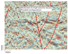
Continuous, low-frequency (10 Hz), moderate-to-strong amplitude reflectionsLacustrine
SF2Applsci 15 07895 i002Moderately continuous, mid-frequency (15 Hz), medium-amplitude reflectionsBraided-river-delta plain/Fan-delta plain
SF3Applsci 15 07895 i003Discontinuous, mid-frequency (12 Hz), weak-amplitude reflectionsBraided-river-delta front/Fan-delta front
Disclaimer/Publisher’s Note: The statements, opinions and data contained in all publications are solely those of the individual author(s) and contributor(s) and not of MDPI and/or the editor(s). MDPI and/or the editor(s) disclaim responsibility for any injury to people or property resulting from any ideas, methods, instructions or products referred to in the content.

