Abstract
The Yuanjue Grottos are representative of the sandstone grottos in southwest China. The structural stability of their wallrocks has suffered a certain degree of damage, resulting from weathering cavities, which seriously threatens the long-term preservation of these cultural relics. This study utilizes 3D numerical simulation to assess the impact of weathering cavity depth on the structural stability of the grottos. The results reveal that the presence of cavities has led to significant wallrock deformation and settlement, particularly in the front side of the entrance and baseplate area. As the cavity depth increases, the deformation effect intensifies. This study also characterizes the relationship between stress deformation and the distribution of weathered fissures, indicating that joint areas are more susceptible to spalling. Displacement monitoring indicates that the baseplate has experienced uplift, followed by settlement as the cavity depth increases, suggesting an initial phase of elastic deformation followed by plastic and brittle deformation stages, which is consistent with the numerical simulation results. Notably, the baseplate’s settlement trend was found to accelerate when the cavity depth exceeded 4 m, with significant changes being observed when the depth exceeded 5 m. Therefore, the depth of the weathering cavity beneath the entrance of the Yuanjue Grottos should be controlled within 5 m, in order to ensure their long-term stability. This research contributes to the understanding of the mechanisms affecting the structural stability of grottos and provides valuable insights for conservation efforts.
1. Introduction
Grottos, as significant repositories of Buddhist cultural studies, have garnered substantial scholarly interest within the academic community [1,2]. A substantial corpus of the sculptural and pictorial representations within grottos serves as a testament to the evolution of religious culture and the progressive development of human social ideologies. These artifacts, embodying high artistic and scientific significance, provide invaluable insights into the historical and cultural narratives of the era. The Yuanjue Grottos were founded in 1174 AD, and are an example of the famous grottos in southwest China (Figure 1). The Yuanjue Grottos have good structural stability due to their scientific design and construction, which effectively solves their drainage and lighting problems. The sculptures in the Yuanjue Grottos are perfectly integrated with the landscape, and are considered an invaluable culture treasure.
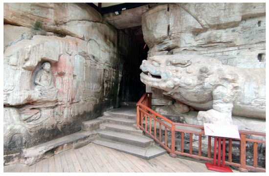
Figure 1.
Panoramic view of the entrance of the Yuanjue Grottos.
After 850 years, due to the long-term effects of various natural forces, a large number of fissures have formed due to weathering and denudation [3]. A great deal of cavities have formed, along with weathering, as the fissures have gradually expanded [4,5]. The maximum width of the weathering cavities beneath the baseplate of the grottos reaches 3.5 m, and the maximum depth has reached 10 m, resulting in gradual changes in the stability of the surrounding rock and roof of the Yuanjue Grottos. With the expansion of the weathering cavities beneath the Yuanjue Grottos, the side of the entrance faces the risk of hanging and instability [6]. In order to prevent the instability and damage caused by the weathering cavities beneath the grottos, ancient people used strip stone support for these cavities. However, some of the supporting stones have been fractured, and others now only play a filling role [7]. Due to fissures having formed in the left rear of the roof, the roof of the Yuanjue Grottos is, at present, close to the ultimate stable state [8]. Therefore, it is urgent to analyze the stability of the grottos, as well as study the development trend of the deformation, in order to preserve the cultural relics of the grottos for a long period of time.
At present, commonly used methods for stability analyses of grottos include the engineering analogy method [9,10], the block balance theory method [11], the analytical method [12], the numerical simulation method [13,14,15,16,17], the physical model test method [18,19], and the nonlinear analysis method [20,21]. The engineering analogy method relies heavily on experiential judgment, and it can overlook critical factors due to its subjective nature [10]. Conversely, the block equilibrium theory excels in assessing simple block geometries, but it can be less precise when considering complex or irregular forms [11]. Analytical methods are particularly effective for caverns with a regular configuration, yet they encounter limitations when analyzing rock masses under high stress, especially in anisotropic conditions [12]. Physical model testing is costly, and its accuracy is subject to the scale and materials selected [18,19]. Finally, nonlinear analysis, while sophisticated and requiring specialized expertise, entails significant computational costs [20,21]. In recent years, the numerical simulation method has occupied a predominant position in the stability analyses of grottos due to its wide applicability [15,16,17,22].
The stability of grottos is often affected by the depth of the weathering cavities beneath it [7,8,12,18]. In order to better explore the protection methods of the grotto landscapes, this study uses the methods of mechanical calculation and three-dimensional numerical simulation to analyze the influence of the depth of the cavities directly below the Yuanjue Grottos, allowing for determination of the stress deformation and stability of the grottos. Our aims were to reveal the state changes in the stress field and displacement field of the surrounding rock, as well as to further obtain new insights into the influence mechanism of the stress and deformation characteristics of the Yuanjue Grottos.
2. Geological and Engineering Background
The study area is located 15 km northeast of Longgang Street, Dazu District, Chongqing City. The area is under the key protection of 14.63 hectares of cultural relics. The terrain is mountainous and hilly, with a sea level of 527 m. Yuanjue Cave is located in the south of Dafo Bay (Figure 2). The architectural style of the grottos inherits the shape and form of the Buddhist statues in northern China. It was listed as a key cultural relic by The State Council in 1961 and as a world cultural heritage site by the United Nations Educational, Scientific and Cultural Organization in 1999.
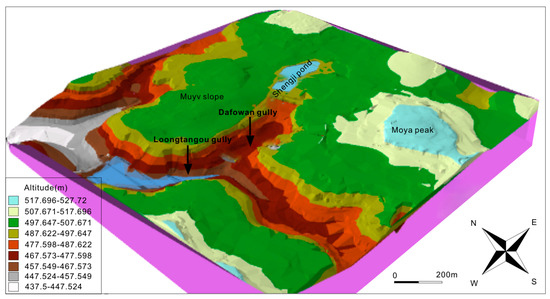
Figure 2.
Topographic map of the Yuanjue Grottos and their adjacent area.
The surrounding rock of the Yuanjue Cave can be subdivided, from top to bottom, into the following 14 layers: (1) artificial fill stratum, (2) fine sandstone, (3) thin-bedded fine sandstone, (4) fine sandstone, (5) interbedded fine sandstone, (6) fine sandstone, (7) pebbled fine sandstone, (8) fine sandstone, (9) mudstone, (10) fine sandstone, (11) mudstone, (12) fine sandstone, (13) mudstone, and (14) interbedded fine sandstone and mudstone [7,19,20]. A comprehensive 3D geological model of the Yuanjue Grottos combined with the 3D point cloud data of the Yuanjue Grottos, with their joints and fissures, was constructed using software such as Autodesk ReCap 2021, Geomagic studio 2015, Rhino 7, and FLAC3D 6.0 (Figure 3).
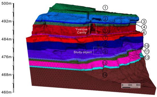
Figure 3.
Strata distribution model of the surrounding rocks. ① artificial fill stratum, ② fine sandstone, ③ thin-bedded fine sandstone, ④ fine sandstone, ⑤ interbedded fine sandstone, ⑥ fine sandstone, ⑦ pebbled fine sandstone, ⑧ fine sandstone, ⑨ mudstone, ⑩ fine sandstone, ⑪ mudstone, ⑫ fine sandstone, ⑬ mudstone, and ⑭ interbedded fine sandstone and mudstone
The weathering cavities are mainly distributed in the five layers of soft rock in the surrounding rock of the Yuanjue Grottos (Figure 3 and Figure 4), including the third layer of fine sandstone, the fifth layer of thin-layer fine sandstone, the seventh layer of pebbled fine sandstone, the eighth layer fine sandstone, and the ninth layer of mudstone. The width of the maximum cavity in the third layer of fine sandstone is 6.5 m, and the maximum depth is 1.6 m. The width of the maximum cavity in the fifth layer of fine sandstone is 2.3 m, and the maximum depth is 1.2 m. The width of the maximum cavity in the seventh layer of fine sandstone is 4.2 m, and the maximum depth is 12 m. The width of the maximum cavity in the ninth layer of fine sandstone is 2.7 m and the maximum depth is 3.1 m, which has been filled and repaired with stone strips. A certain scale cavity has also developed in the eleventh layer of the mudstone, with a maximum cavity width of 7.2 m and a maximum depth of 3.8 m, which has been filled and repaired with stone strips.
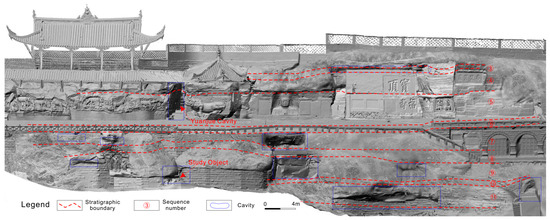
Figure 4.
Cross-section diagram of the wallrocks of the Yuanjue Grottos. ③ thin-bedded fine sandstone, ④fine sandstone, ⑤ interbedded fine sandstone, ⑥ fine sandstone, ⑦ pebbled fine sandstone, ⑧ fine sandstone, ⑨ mudstone, ⑩ fine sandstone, ⑪ mudstone
3. Model Construction and Parameter Selection
The process of 3D numerical modeling can be subdivided into four steps. First, a three-dimensional laser scanner was used to obtain point-cloud modeling data. Second, a three-dimensional modeling process was performed based on the point-cloud modeling data to obtain a three-dimensional model. Third, a texture-mapping process was performed on the three-dimensional model to obtain a grotto mode. Fourth, combined with geological surveys, a comprehensive 3D geological model of the Yuanjue Grottos with their joints and fissures was constructed using software such as Autodesk ReCap, Geomagic studio, Rhino, and FLAC3D.
For this simulation, the target was the cliff which, under static conditions, does not exhibit significant internal deformation or flow. Therefore, the Mohr–Coulomb model was employed for the analysis. In FLAC3D, the Mohr–Coulomb model was represented in a three-dimensional principal stress space, where the corresponding strain components were the three principal strains. In the principal stress space, the incremental equation of Hooke’s law can be expressed as follows:
where δσij and δϵij are the increments of stress and strain, respectively; G is the shear modulus; K is the bulk modulus; and δij is the Kronecker delta, which is 1 if i = j and 0 otherwise.
δσij = 2Gδϵij + (3K − 2G)(δϵkkδij)/3,
δϵij = (3K − 2G)(δσij − δσkkδij/3)/6K + 2G(δϵij − δϵkkδij/2)δϵij/3.
The Mohr–Coulomb failure criterion was then applied to determine the onset of failure based on the principal stresses, with the failure occurring when the shear stress on any potential failure plane exceeded the shear strength, as defined by the Mohr–Coulomb parameters (cohesion c and friction angle ϕ):
where τ is the shear stress, σn is the normal stress, and ϕ is the friction angle of the material.
τ = c + σntan(ϕ)
There were 787,148 elements and 176,620 nodes in the wallrock model of the Yuanjue Grottos, and there were 113,592 elements and 21,563 nodes in the local model of the roof of the grottos.
The weathering cavities directly beneath the Yuanjue Grottos were selected as the study object to carry out 3D geological modeling analysis in accordance with our geological investigation. The outermost cavity was 3.5 m wide, the innermost width was 0.35 m, and the depth was 10 m in the modeling. The weathering cavities were divided into 10 groups on the basis of a 1 m depth variate. A three-dimensional geological model of the Yuanjue Grottos with their cavities was established, as shown in Figure 5.
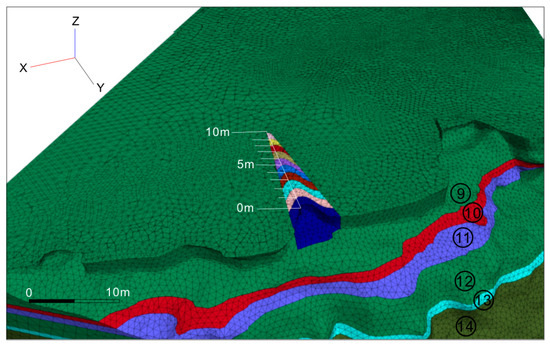
Figure 5.
Cavity grouping diagram. The numerical labels refer to the same stratigraphic units illustrated in Figure 3. ⑨ mudstone, ⑩ fine sandstone, ⑪ mudstone, ⑫ fine sandstone, ⑬ mudstone, and ⑭ interbedded fine sandstone and mudstone. The green grid represents sandstone, the red grid represents thinly layered fine sandstone, the blue grid and the cyan color represents mudstone, and the dark green represents interbedded mudstone and sandstone.
The stratigraphic sequence of the Yuanjue Grottos was obtained through drilling and coring, the physical and mechanical parameters of the different rocks were measured or tested in the laboratory, and the petrophysical parameters used in the numerical simulation were also determined, as shown in Table 1.

Table 1.
The stratigraphic lithology and mechanical parameters of the wallrocks.
4. Discussion
A weathering cavity is a space with low temperature and high humidity, which can result in water vapors condensing on the wallrock of the cavity, leading to damages due to corrosion, softening, and other types of erosion; alternatively, the accumulation of standing water can keep the cavity in a humid state for a long time, which further aggravates the weathering damage of the grottos [18,19]. Unloading caves can be formed with an increase in the depth of weathered caves, which could cut through the grotto rock mass and, subsequently, destroy the cultural relics in the grotto [19]. However, previous studies on the stability of grottos have mainly focused on the mechanism of the unloading fissure in the grottos [7,8,13,14,15,16,17,18,19,20,21]. Therefore, this study took the weathering cavities beneath the Yuanjue Grottos as the research object, and the influence of the cavity depth on the structural stability of the Yuanjue Grottos was analyzed by numerical simulation.
4.1. Influence of the Cavity Depth Variation on the Overall Deformation of Yuanjue Cave
The vertical displacement nephograms of the surrounding rock under the different depths of the weathering cavities, in accordance with the numerical calculation results, are shown in Figure 6, and a displacement vector diagram of the wallrocks under different cavity depths are shown in Figure 7. Due to the existence of the cavities, the wallrock deformation is relatively significant, and the wallrock settlement occurred in a certain range at the top of the cavities. The influence of the weathering cavities on the deformation of wallrock has also increased along with an increase in depth. The characteristics and influence of the cavity depth is similar to that of the new faults [20].
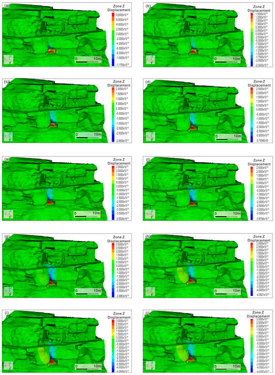
Figure 6.
Vertical displacement nephograms of wallrock of the Yuanjue Grottos under different cavity depths. (a–j) denote cavity depths of 0–10 m, respectively.
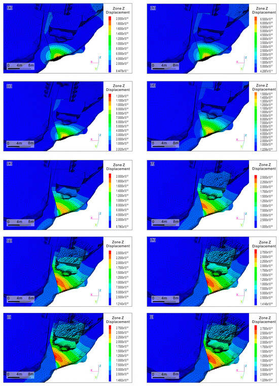
Figure 7.
Displacement vector diagrams of wallrock of the Yuanjue Grottos under different cavity depths. (a–j) denote cavity depths of 0–10 m, respectively.
The weathering cavities mainly affect the stress deformation of the front side of the entrance and the front side of the baseplate of the Yuanjue Grottos (but has little influence on the roof) according to the displacement nephograms and displacement vector diagrams of the different depths (Figure 6 and Figure 7). In contrast, the tensile stress of the roof above the entrance of Yuanjue Grottos was found to be the greatest, and the rock there is more prone to spalling than other parts (Figure 7). This conclusion is consistent with previous numerical simulation results, where it was found that the maximum principal stress is concentrated at the entrance of the Yuanjue Grottos [7,20].
In addition, the stress deformation degree of the baseplate of the Yuanjue Grottos is related to the distribution of weathered fissures according to the displacement nephograms and displacement vector diagrams (Figure 6 and Figure 7). The stress deformation in the joint area of fissures is obvious (Figure 7), and the spalling is the easiest to detect; meanwhile, the surrounding rock that are without fissures basically do not deform and do not change with the depth of the cavity.
4.2. Influence of the Cavity Depth Variation on the Deformation of the Baseplate of the Yuanjue Grottos
As mentioned above, the influence of the weathering cavity on the Yuanjue Grottos is controlled by the fissures [19,20]. Therefore, displacement monitoring stations were set up at the intersection of the fissures in order to further ascertain the influence degree of the weathering cave on the Yuanjue Grottos, where the aim was to explore the deformation regularity of the baseplate of the Yuanjue Grottos. There were two fissures in the bottom of the Yuanjue Grottos, named Fissures J10 and L8, which are almost vertically crossed (Figure 8). The baseplate of the Yuanjue Grottos is divided into four areas, and two displacement monitoring points were selected in each area. This was performed to analyze the vertical displacement of each area that occurred due to the change in cavity depth, and the curve of vertical displacement change with the depth of cavity was drawn (Figure 9).
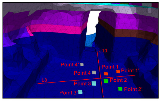
Figure 8.
Diagram of the baseplate area division of the Yuanjue Grottos.
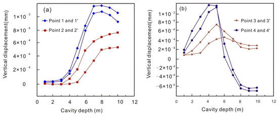
Figure 9.
The vertical displacement variation curves of the measuring points in the different areas of the baseplate with increases in the cavity depth. (a) The vertical displacement variation curves of the measuring points in the right area of the baseplate, (b) The vertical displacement variation curves of the measuring points in the left area of the baseplate.
As can be seen from Figure 9, with increases in the cavity depth, the baseplate of the Yuanjue Grottos produced a certain uplift, indicating that the front area of the entrance of the Yuanjue Grottos presents an overall forward trend in the early stage of cavity development. This is a typical elastic rebound phenomenon, suggesting that the rock strata of the baseplate are in the stage of elastic deformation [8] (Zhu et al., 1993). The rock strata of the baseplate absorbed a certain amount of potential energy due to gravity. The gravity of the lower particles was relieved with increases in the cave depth; this potential energy causes an uplift in the above-rock strata of the baseplate. The uplift heights of the displacement monitoring of Points 1 and 4 were found to be greater than that of Points 2 and 3, which also proves the above conclusion.
The evolution processes of the vertical displacement of Points 1 and 2 can be subdivided into three stages. Stage 1 represents when the cavity depth is less than 4 m, where vertical displacement changes slowly. Stage 2 represents when the cavity depth is between 4 m and 7 m, where the vertical displacement of Points 1 and 2 has entered an accelerated change stage along with increases in the cavity depth. Stage 3 represents when the cavity depth is more than 7 m, where the vertical displacement of Points 1 and 2 tends to gently change along with increases in the cavity depth. Stages 1 and 2 belong to the elastic deformation stage, while Stage 3 indicates where the rock strata of the baseplate transform into the plastic and brittle deformation stage [22].
The evolution processes of the vertical displacement of Points 3 and 4 can be subdivided into two stages (Figure 9b). Stage 1 represents when the cavity depth is less than 5 m, where the vertical displacement of Points 3 and 4 increases with increases in the depth and the two areas are constantly uplifted. Stage 2 represents when the cavity depth is more than 5 m, where the vertical displacement of Points 3 and 4 has a reverse steep drop, where the uplift of the two areas continuously decreases, and where the vertical settlement occurs in Point 4. Stages 1 and 2 belong to the elastic and brittle deformation stages, respectively.
When comparing the vertical displacement of the four displacement monitoring points, Point 1 was found to be going through a longer phase of the elastic deformation stage than that of Point 4, suggesting that the development direction of Fissure L8 is from Point 4 to Point 1. The direction of fissure development might be related to the location of the cavities below, as the locations of the cavities are biased with respect to the location of the displacement monitoring of Point 4 (Figure 3). The sudden drop of Points 3 and 4 with a cavity depth of 5 m indicates that Fissure L8 had a faster initial development speed. In contrast, Points 1 and 2 reflect the late slow development of Fissure L8, and the change may be related to the formation of the new Fissure J10. It was found that the fracture rate of the baseplate of the Yuanjue Grottos slowed down after the two fissures intersected. The structural evolution was also found to be consistent with the deformation processes of the wallrocks of the Yuanjue Grottos. In conclusion, the depth of the weathering cavities beneath the entrance of the Yuanjue Grottos should be controlled within 5 m, and supporting measures are needed to protect the grottos above.
5. Conclusions
Based on a geological investigation of the cavity depth beneath the entrance of the Yuanjue Grottos, a numerical model was established to calculate and analyze the influence of the cavity depth on the vertical displacement of the wallrocks at the entrance of the Yuanjue Grottos and the vertical displacement of the baseplate. The conclusions can be summarized as follows.
- With increases in the cavity depth, the front side of the entrance of the Yuanjue Grottos presents an overall forward trend, which may result in the formation of fissures in the front side of the Yuanjue Grottos.
- The weathering cavities mainly affect the stress deformation of the front side of the entrance and the front side of the baseplate of the Yuanjue Grottos.
- The settlement trend of the fissured baseplate presents an obvious accelerated change when the cavity depth exceeds 4 m, and the settlement trend of the fissured baseplate shows obvious differences when the cavity depth exceeds 5 m. The depth of the weathering cavities beneath the entrance of the Yuanjue Grottos should be controlled within 5 m.
Author Contributions
Conceptualization, B.L. and J.L.; methodology, B.L.; software, Y.L.; validation, J.C. and F.Z.; formal analysis, Y.L.; investigation, B.L. and J.C.; resources, J.C.; data curation, Y.L.; writing—original draft preparation, B.L. and J.L.; writing—review and editing, J.L., J.C. and Y.L.; visualization, J.C. and Y.L.; supervision, J.L.; project administration, J.L.; funding acquisition, F.Z. All authors have read and agreed to the published version of the manuscript.
Funding
This work was financially supported by the National Key Research and Development Program of China (2022YFC2905400), the Key Projects for Technological Innovation and Application Development in Chongqing (CSTB2022TIAD-KPX0095), and the National Natural Science Foundation of China (42202055).
Institutional Review Board Statement
Not applicable
Informed Consent Statement
Not applicable
Data Availability Statement
The original contributions presented in the study are included in the article, further inquiries can be directed to the corresponding authors.
Acknowledgments
Thanks are given to Chuchen Luan from the Northeastern University (China) for his constructive suggestions and comments.
Conflicts of Interest
The authors declare that there are no conflicts of interest.
References
- Monteith, F. Towards a landscape archaeology of Buddhist cave-temples in China. Antiquity 2017, 91, 8. [Google Scholar] [CrossRef][Green Version]
- Germanovich, L.N.; Dyskin, A.V. Fracture mechanisms and instability of openings in compression. Int. J. Rock Mech. Min. Sci. 2000, 37, 263–284. [Google Scholar] [CrossRef]
- Hou, Y.; Zhang, J.; Li, B.; Gong, Y.; Xu, Y.; Wang, M.; Zhu, C. Stability study of the roof plate of the Yuanjue Cave based on the equivalent support stiffness method. Appl. Sci. 2023, 13, 4451. [Google Scholar] [CrossRef]
- Meng, Z.G.; He, M.C.; Tao, Z.G.; Li, B.; Zhao, G.; Xiao, M.R. Three-Dimensional Numerical Modeling and Roof Deformation Analysis of Yuanjue Cave Based on Point Cloud Data. Adv. Civ. Eng. 2020, 2020, 8825015. [Google Scholar] [CrossRef]
- Bienlawski, Z.T. Engineering Classification of Jointed Rock Mass. Trans. S. Africa Inst. Civ. Engrs. 1973, 15, 335–343. [Google Scholar]
- Martin, C.D.; Read, R.S.; Martino, J.B. Observations of brittle failure around a circular test tunnel. Int. J. Rock Mech. Min. Sci. 1997, 34, 1065–1073. [Google Scholar] [CrossRef]
- Goodman, R.; Shi, G. Block Theory and Its Application to Rock Engineering; Prentice-Hall, Inc.: Englewood Cliffs, NJ, USA, 1985. [Google Scholar]
- Zhu, D.Y.; Qian, Q.H.; Zhou, Z.S.; Xu, W.H. New method for calculating mapping function of opening with complex shape. Chin. J. Rock Mech. Eng. 1993, 3, 279–282. [Google Scholar]
- Hajiabdolmajid, V. Mobilization of Strength in Brittle Failure of Rock. Ph.D. Thesis, Queen’s University, Kingston, Canada, 2001. [Google Scholar]
- Hajiabdolmajid, V.; Kaiser, P.K.; Martin, C.D. Modelling brittle failure of rock. Int. J. Rock Mech. Min. Sci. 2002, 39, 731–741. [Google Scholar] [CrossRef]
- Hu, B.; Zhang, Z.Y.; Huang, R.Q.; Qiang, X. Development of pre-processing package for FLAC3d and verification of its simulating effects. Chin. J. Rock Mech. Eng. 2002, 21, 1387–1391. [Google Scholar]
- Li, Z.K.; Lu, D.R.; Zhong, S.Y. Development and application of new technology for 3D geomechanics model test of large underground houses. Chin. J. Rock Mech. Eng. 2003, 22, 7. [Google Scholar] [CrossRef]
- Bhandari, T.; Hamad, F.; Moormann, C.; Sharma, K.G.; Westrich, B. Numerical modelling of seismic slope failure using MPM. Comput. Geotech. 2015, 23, 126–134. [Google Scholar] [CrossRef]
- Chen, J.; Sheng, T. Experiment study on thestresses and stability of Geheyan Gravity Arch Dam of the Qingjiang River. In Practice and Theory of Arch Dam: Proceedings of the International Symposium on Arch Dam; Hehai University Press: Nanjing, China, 1992. [Google Scholar]
- He, X.S.; Zhang, L.; Chen, Y. Stability study of abutment of Jinping-I arch dam by geomechanical model test. In Proceedings of the 6th International Conference on Physical Modelling in Geotechnics, Hong Kong, China, 4–6 August 2006; pp. 419–423. [Google Scholar]
- Harrison, J.P.; Hudson, J.A. Engineering Rock Mechanics. Part 2: Illustrative Workable Examples; Pergamon: Oxford, UK, 2000. [Google Scholar]
- Jing, L. A review of techniques, advances and outstanding issues in numerical modeling for rock mechanics and rock engineering. Int. J. Rock Mech. Min. Sci. 2003, 40, 283–353. [Google Scholar] [CrossRef]
- Sun, L.F. Study on the Stability of the Underground Cavern Group under the Conditions of Different In Situ Stresses’ Characteristics and Different Yield Criteria. Ph.D. Thesis, Shandong University, Jinan, China, 2009. [Google Scholar]
- Meng, Z.G.; Fan, F.N.; Cui, X.B.; Tao, S.; Cao, Y. Numerical Modeling and Stability Analysis of Surrounding Rock of Yuanjue Cave. Geofluids 2021, 2021, 6652271. [Google Scholar] [CrossRef]
- Meng, Z.G.; Fan, F.N.; Qi, G.; Cui, X.B.; Ma, J. Stability monitoring and deformation laws of the Yuanjue Cave in the influence zone of the unloading zone. Geofluids 2021, 2021, 6652271. [Google Scholar] [CrossRef]
- Tao, Z.; Luo, S.; Wu, D.; Qiao, Y.; Zhao, G.; Meng, Z. Stability Evaluation of Deformation (Denudation) of Yuanjue Rock Cave Roof Based on Multisource Monitoring. Shock. Vib. 2020, 2020, 8825612. [Google Scholar] [CrossRef]
- Yang, L.L.; Xu, W.Y.; Meng, Q.X.; Wang, R.B. Investigation on jointed rock strength based on fractal theory. J. Central South Univ. 2017, 24, 1619–1626. [Google Scholar] [CrossRef]
Disclaimer/Publisher’s Note: The statements, opinions and data contained in all publications are solely those of the individual author(s) and contributor(s) and not of MDPI and/or the editor(s). MDPI and/or the editor(s) disclaim responsibility for any injury to people or property resulting from any ideas, methods, instructions or products referred to in the content. |
© 2024 by the authors. Licensee MDPI, Basel, Switzerland. This article is an open access article distributed under the terms and conditions of the Creative Commons Attribution (CC BY) license (https://creativecommons.org/licenses/by/4.0/).