Abstract
This study focuses on the application of ground-penetrating radar (GPR) in conducting field surveys and data processing at the northern campus of Jilin Jianzhu University. The research site’s geographical location and overall conditions are described. A detailed layout of the survey lines for 3D surveys is presented. The collected data undergo basic processing and interpretation, identifying multiple target bodies and their associated electromagnetic responses. Advanced analyses such as 3D imaging, common attribute analysis, and time-varying centroid frequency attribute analysis are employed to investigate underground features and potential pipe networks. The case study in this research demonstrates that the integration of 3D GPR surveys and time-varying centroid frequency analysis can effectively assess the attenuation characteristics of subsurface media and structures, thereby enhancing the overall prospecting and data interpretation capabilities of GPR.
1. Introduction
With the development process of urbanization, people require more scientific and reasonable planning and design for urban infrastructure. This requires us to carry out more accurate geological surveys and comprehensive measurements. At the same time, it is also necessary for us to arrange the corresponding monitoring and recording work due to the increase in the service life of buildings. The external surfaces of existing building structures can be directly observed and analyzed with the naked eye, but it is difficult to assess material loss within. Similarly, for underground structures, while previous geological survey reports and engineering records can provide insight, data loss and changes in underground media due to external influences such as the environment are also common. This undoubtedly requires us to choose an appropriate testing method.
Ground-penetrating radar (GPR) is used as a geophysical method to identify near-surface subsurface target bodies by exciting high-frequency pulsed electromagnetic waves [1,2]. In recent years, its applications have become more and more extensive. For example, it has been applied in the analysis of historical buildings [3,4] and typical case detection [5,6], for crack detection of urban highway roads [7,8,9,10], and in the evaluation of the maintenance effect of concrete-based construction materials [11,12]. Compared with traditional detection methods in the civil engineering field, it has unique advantages such as non-destructiveness and high resolution in recognizing the target body. Therefore, the use of the GPR method will be a wiser choice.
GPR imaging involves analysis of electromagnetic waves reflected from the subsurface medium. Normally, we scan and collect data along survey lines and proceed to two-dimensional (2D) imaging analysis. The information in the profile is observed to infer the subsurface medium characteristics. Based on the magnitude of the difference between the dielectric constant of the target and the surrounding medium, we can find the corresponding “hyperbolic” reflections, and thus make preliminary inferences about the location and shape of the target [13,14]. However, it is difficult to obtain the exact geometry of the target from the profile data obtained from a single measurement line. In this case, we can recognize the target more intuitively by adopting a three-dimensional (3D) imaging method [15,16,17], which arranges the 2D images in the form of slices. At present, 3D imaging application technology based on GPR is becoming increasingly mature, with detection in archaeological applications [18,19], including the detection of underground graves [20,21], etc.
The resolution of the radar data collected using GPR equipment at the actual site is directly related to the center frequency of the selected GPR equipment. At the same time, due to the complexity of the underground medium of the site, the accuracy of the information brought by C-scan is still debatable. At this point, we can use the corresponding attribute extraction methods for further analysis. Through the Hilbert transform, the real signal can be transformed into a complex signal, and instantaneous amplitude, instantaneous frequency, and instantaneous phase can be extracted as instantaneous properties to predict the properties of underground media [22,23,24,25]. The time-varying centroid frequency can be used to track the change in signal dominant frequency with time and identify the target [26,27,28]. At the same time, the use of machine learning [29,30] can optimize the effectiveness of the selected method.
In this study, we established multiple survey lines in a grid-like intersection at the experimental site and utilized 3D imaging to visualize the target body geometry and other relevant information. The experiment aims to analyze the current underground structure of the site. The instantaneous energy and time-varying centroid frequency methods offer more detailed information for identifying underground structural characteristics and potential pipe networks.
2. GPR Field Survey and Data Processing
2.1. Description of the Test Site in the JLJU Campus
The research site is located on the northern campus of Jilin Jianzhu University, established in 1956 and situated in the southeastern region of Changchun City in northeast China (125.35° E, 43.88° N). The geographical location of the test site is indicated in Figure 1.
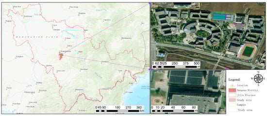
Figure 1.
Geographical location of the test site (north campus of Jilin Jianzhu University, Changchun, Jilin province, China).
The testing location is situated between the student bath facilities and the cafeteria and features an extensive underground pipe network suitable for testing, comparing, and detecting subsurface geophysical targets, including by GPR field survey. The test site is equipped with sewage or rainwater drainage wells and buried cables to meet the needs of drainage and power supply. The overall condition can be observed from the drone-captured image in Figure 2a. Field observations revealed rainwater catch basins (Figure 2d), manhole covers for access to underground pipe networks (Figure 2b,c), and cavities (see Figure 2e, initially presumed to be mouse holes). Considering the campus has been in operation for over a decade, it is conceivable that its subsurface conditions have undergone changes.
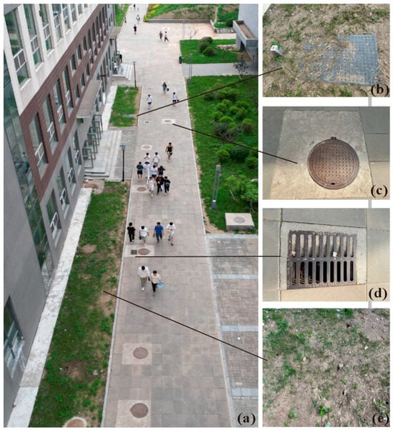
Figure 2.
Images of the test site, including a drone-captured image (a) and photos of the target objects such as a square manhole cover (b), round manhole cover of underground pipe network (c), mouse cavities (d), and rainwater catch basins (e).
2.2. Field Data Acquisition
Based on the on-site field survey, we established vertically staggered lateral survey line grids (about 47 × 8 m, three longitudinal (inline) and five transverse (crossline) survey lines) to effectively conduct a 3D survey while avoiding surface obstacles. A schematic plan view of survey line layout is illustrated in Figure 3, with the legends providing illustrations of surface features for various target bodies for reference. When planning survey lines, if unavoidable surface obstructions (such as manhole covers, rainwater catch basins) were encountered, they were considered as reference points for the cross-section survey, although this leads to increased complexity in subsequent processing and interpretation.

Figure 3.
Schematic view of survey line layout for GPR acquisition at the test site, with the legends providing illustrations of surface features for various target bodies for reference.
We selected the MALÅ GX GPR system equipped with a 450 MHz center frequency antenna to gather data along the arranged survey lines. Data acquisition was carried out using the “distance mode” at a sampling frequency of 5120 MHz and a trace interval of 0.02 m, with each A-scan containing a time window set at 108 ns comprising 553 samples. In total, eight GPR B-scan datasets were obtained (three inline profiles and five crossline profiles). During the real data acquisition process, we slowed down the speed at which the radar equipment was manually pulled. We aimed to maintain a 30° angle between the tie rod and the measurement line to ensure that the radar equipment moved closely to the ground, as the longitudinal line and five cross lines intersect with paving, curbs and lawns, resulting in an uneven surface with raised obstacles.
3. Results
3.1. Basic Data Processing and Interpretation
The collected GPR data primarily depict the coupling of excitation and receiving antennas, known as “direct wave”. In order to achieve a meaningful interpretation of underground media, data processing is often necessary based on the inherent characteristics of the data. We conducted fundamental data processing procedures on the gathered radar profiles, including direct wave removal (typically the initial step to mitigate air coupling effects), gain adjustment (usually the second step to amplify the signal for clearer target information representation), denoising techniques (such as band-pass filtering and median filtering, typically the third step to eliminate interference signals in the data), and deconvolution (generally the fourth step to compress radar wavelet and enhance resolution). The inline B-scan profiles and crossline B-scan profiles obtained after the initial GPR data processing are displayed in Figure 4a–c (inline 1~3) and Figure 5a–e (crossline 1~5), respectively. The legends show illustrations for various target bodies for reference.
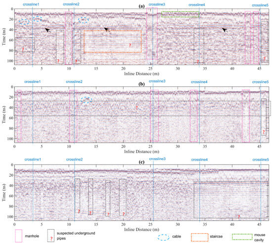
Figure 4.
The inline B-scan profiles after basic GPR data processing: (a) inline 1, (b) inline 2, and (c) inline 3.
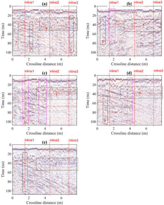
Figure 5.
The crossline B-scan profiles after basic GPR data processing: (a) inline 1, (b) inline 2, and (c) inline 3.
The radar waves in these profiles demonstrate consistent characteristics, revealing distinct layers such as a surface layer (approximately 10~30 ns), concrete base layer (approximately 30~60 ns), and a clay layer beyond 60 ns. GPR equipment excites electromagnetic waves to propagate downward in the form of spherical waves, and the shape function of the target body is a hyperbolic function in mathematics. Therefore, we generally observe the “hyperbola” in radar images to identify buried targets. However, due to the inhomogeneity of the underground medium, various deformations of the hyperbola form will occur in practical detection. Based on the surface observation records, we were able to identify the electromagnetic wave response in these profiles related to the majority of target bodies, as illustrated in Figure 2.
We compiled a comprehensive list of target bodies, including those with markers or exposed on the surface, as detailed below.
- Manhole covers (square or round) and the rainwater catch basin
The presence of manhole covers of varying shape (square or round) and visible rainwater catch basins at ground level typically indicate the existence of underground pipeline networks for the collection and transportation of rainwater or sewage, as well as for access for maintenance and repair of underground pipe systems. The radar waves often illustrated chaotic multiples near the manhole covers over underground pipelines or rainwater catch basins, propagating downward multiple times and causing a discontinuity in events compared to adjacent sections in the GPR profiles.
In Figure 4 and Figure 5, we utilize rose dashed boxes to delineate the sections directly across the manhole covers, and employ black dashed boxes with a question mark at the bottom to indicate adjacent areas where underground pipes are suspected and which require further investigation.
- Cafeteria wall and the foundation below
In the profile of inline 1, there are horizontal events present (at approximately 35 to 40 ns, as shown in Figure 4a), and the inclined layers observed in all the crossline profiles in Figure 5 correspond to reflections from the wall and the foundation below.
- Staircase
Near the staircase, at a distance of approximately 13 to 23.5 m from the starting point mentioned in inline 1, there is a lack of discernible reflections or anomalies in the shallower section compared to the previously mentioned horizontal events, indicating an absence of significant subterranean foundation beneath the staircase.
In contrast, radar waves beyond the 40 ns exhibit a consistent oscillation pattern in the deeper part that extends beyond the horizontal events mentioned earlier, as depicted by the square section highlighted by the orange dotted box in Figure 4a. It is also hypothesized that there may be an underground space present, which will be further investigated at a later time.
- Electrical cables (with markers)
The cable post corresponds to the independent hyperbola in the profile. We marked these hyperbola anomalies with the light blue dashed oval.
- Mouse cavities
The intermittent reflection on the ground may be attributed to the presence of mouse holes, as indicated by the green dashed box (located at approximately 27 to 33 m) in Figure 4a. It is evident that these burrows are not very deep.
3.2. Three-Dimensional Imaging and Common Attribute Analysis
We constructed a 3D data volume using the inline and crossline GPR B-scans, as shown in Figure 6. To further analyze the aforementioned characteristics, we choose multiple interleaved areas within the 3D data volume for region mapping, examine the characteristics with distinct surface identification, and analyze the profile features of the aforementioned uncertain regions.
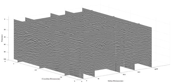
Figure 6.
Three-dimensional data cube based on the acquired inline and crossline B-scan profiles.
To facilitate the analysis of the surrounding areas where suspected underground pipe networks are located in the 3D data volume, we can capture zoomed-in images at the interleaved areas of the inline and crossline survey lines. In Figure 7, we provide examples of interleaved areas between inline 1 and inline 2 with each crossline survey line, using the same masks as shown in Figure 4 and Figure 5. Specifically, we also mark hyperbola anomalies with dashed ovals and utilize rose dashed boxes to delineate sections directly across the manhole cover. Additionally, black dashed boxes are employed at the middle and bottom to indicate adjacent areas where underground pipes are suspected.
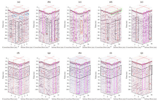
Figure 7.
Zoomed-in images at the interleaved areas of five crossline survey lines with inline 1 (a–e); zoomed-in images at the interleaved areas of five crossline survey lines with inline 2 (f–j).
Figure 7a–e depict magnified images of the interleaved areas where five crossline survey lines intersect with inline 1. These subfigures reveal the presence of manholes and potential underground spaces in both the inline and crossline dissected surface, providing a more intuitive representation. We adhere to the indicators in Figure 4 and Figure 5, utilizing dashed ovals to denote hyperbola anomalies, rose dashed boxes to mark the manholes exposed at the ground surface, and black dashed boxes to indicate suspected underground pipelines or spaces. Figure 7f–j are zoomed-in images at the interleaved areas of five crossline survey lines with inline 2. At 25~55 ns, there may exist a layer that corresponds to the underground spaces.
Regarding the zoomed-in data cube mentioned above, we utilize complex trace analysis to extract the instantaneous energy (or instantaneous amplitude), as depicted in Figure 8. In Figure 8a, anomalies in the form of hyperbolas can also be observed within the dashed ovals. Within these subfigures, the overall distribution of instantaneous energy exhibits a predominantly horizontal or slightly inclined layered pattern. Notably, at locations where manholes and underground pipelines or spaces are present, we identified four distinct types of formations: layered (with strong energy), layered (with weak energy), cluttered (with strong energy), and cluttered (with weak energy) (see Table 1). In Figure 8, the RGB color level diagram represents the intensity of instantaneous energy.
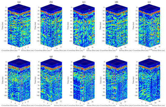
Figure 8.
Instantaneous energy of the interleaved areas of five crossline survey lines with inline 1 (a–e); instantaneous energy of the interleaved areas of five crossline survey lines with inline 2 (f–j).

Table 1.
Form of instantaneous energy and the corresponding types of underground spaces.
3.3. Time-Varying Centroid Frequency Attribute Analysis
We then utilize the time-varying centroid frequency attribute proposed in our previous work [9] to further assess the attenuation at the interleaved areas, as depicted in Figure 9 and Table 2. In lossy media, there is a noticeable reduction in centroid frequency attributed to the attenuation effect (i.e., dielectric losses) with an increase in the propagation time of radar waves. This reduction is more prominent in water compared to common lossy media such as soil and concrete. Additionally, minimal attenuation is observed during wave propagation through air.
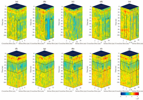
Figure 9.
The time-varying centroid frequency of the interleaved areas of five crossline survey lines with inline 1 (a–e); the time-varying centroid frequency of the interleaved areas of five crossline survey lines with inline 2 (f–j).
Table 2.
The form of instantaneous energy and centroid frequency and the corresponding type of underground space and the serial number marked in the corresponding diagram.
In Figure 9a, the centroid frequencies exhibit two distinct characteristics in the vicinity of underground pipelines or spaces: minimal attenuation around the center frequency of 450 MHz (indicated by dashed boxes labeled “①”), and a noticeable reduction in the range of 200 to 300 MHz (indicated by dashed boxes labeled “②”). In Figure 9b, the centroid frequencies also exhibit two distinct characteristics near manholes with metal covers exposed on the ground surface: minimal attenuation around the center frequency of 450 MHz (indicated by dashed boxes labeled “③”), and a noticeable reduction in the range of 200 to 300 MHz (indicated by dashed boxes labeled “④”). Similar observations can be made in other sub-figures.
It is worth noting that, in Figure 9f–j, shallow underground spaces can be identified (labeled as “②”), indicating the presence of an underground pipe network beneath the second survey line distributing rainwater and sewage or wastewater from a nearby bathroom.
4. Discussion
The underground space in cities can generally be categorized into two main types: utility tunnels used for various lines (such as gas, electricity, and communication), and water pipe networks for draining rainwater or domestic sewage. The presence of water can serve as a distinguishing factor to differentiate the purposes of these underground networks. Manhole covers are convenient identifiers for the type of underground space, but radar wave genetic detection is a relatively effective method for old damaged areas and unmarked areas.
When the ground-penetrating radar passes near a manhole cover, electromagnetic waves oscillate downward from the surface. The presence of air in a line pipe gallery results in regular oscillations on the waveforms or profiles, with slow decay of the frequency components compared to dense soil. If the space is filled with water, the waveforms appear even looser and the frequency components decay more quickly [31]. As the radar passes through areas where underground spaces may exist (not passing the manhole cover), it scatters in the surface soil and oscillates within any cavities present. This results in complex waveforms with a regular hierarchy, visible in both radar profiles and instantaneous amplitude slopes [32,33]. The presence of water also affects instantaneous linear frequency profiles [34,35]. It is important to compare these findings with relatively dense soil without anomalies in all cases.
5. Conclusions
This research focused on a GPR field survey and data processing at a test site on the northern campus of Jilin Jianzhu University. A vertically staggered lateral survey line grid was established for 3D surveying using the MALÅ GX GPR system. Basic data processing and interpretation identified various target bodies and their electromagnetic wave responses. Three-dimensional imaging and common attribute analysis were conducted to further investigate the characteristics and potential underground pipe networks. Time-varying centroid frequency attribute analysis was also utilized to assess attenuation. This study categorized underground spaces in an urban area and described the effects of different conditions on radar wave detections. Overall, this research provides comprehensive insights into the underground conditions at the test site using advanced GPR techniques and data analysis methods. However, we were unable to identify and extract more detailed information regarding underground media, such as specific material composition, water distribution, and other conditions. Our next research focus will be to develop a more comprehensive application for urban infrastructure monitoring.
Author Contributions
Conceptualization, X.Z. and J.P.; methodology and scripts coding, X.Z. and J.P.; validation, H.L. and Q.Y.; formal analysis, X.Z.; investigation, L.Y. and H.Z.; resources and data curation, X.Z.; writing—original draft preparation, X.Z. and J.P.; writing—review and editing, X.Z. and Z.S.; visualization, J.P.; supervision and project administration, X.Z. All authors have read and agreed to the published version of the manuscript.
Funding
This research was also funded by the Scientific Research Programs granted by the Jilin Provincial Department of Science and Technology, China (Grant No. 20240101046JC), and Qin You is funded by the Scientific Research Programs granted by the Jilin Provincial Department of Education, China (Grant No. JJKH20210268KJ).
Institutional Review Board Statement
Not applicable.
Informed Consent Statement
Not applicable.
Data Availability Statement
The data are available on request from the authors.
Acknowledgments
We thank the anonymous reviewers for their time and effort in revision.
Conflicts of Interest
The authors declare no conflicts of interest.
References
- Jol, H.M. Ground Penetrating Radar Theory and Applications; Elsevier: Oxford, UK, 2009. [Google Scholar]
- Grandjean, G.; Paillou, P.; Dubois-Fernandez, P.; August-Bernex, T.; Baghdadi, N.N.; Achache, J. Subsurface structures detection by combining L-band polarimetric SAR and GPR data: Example of the Pyla Dune (France). IEEE. Trans. Geosci. Remote Sens. 2001, 39, 1245–1258. [Google Scholar] [CrossRef]
- Diz-Mellado, E.; Mascort-Albea, E.J.; Romero-Hernández, R.; Galán-Marín, C.; Rivera-Gómez, C.; Ruiz-Jaramillo, J.; Jaramillo-Morilla, A. Non-destructive testing and Finite Element Method integrated procedure for heritage diagnosis: The Seville Cathedral case study. J. Build. Eng. 2021, 37, 102134. [Google Scholar] [CrossRef]
- Rucka, M.; Lachowicz, J.; Zielinska, M. GPR investigation of the strengthening system of a historic masonry tower. J. Appl. Geophys. 2016, 131, 94–102. [Google Scholar] [CrossRef]
- Orlando, L. Detecting steel rods and micro-piles: A case history in a civil engineering application. J. Appl. Geophys. 2012, 81, 130–138. [Google Scholar] [CrossRef]
- Negri, S.; Aiello, M.A. High-resolution GPR survey for masonry wall diagnostics. J. Build. Eng. 2021, 33, 101817. [Google Scholar] [CrossRef]
- Rasol, M.A.; Pérez-Gracia, V.; Fernandes, F.M.; Pais, J.C.; Santos-Assunçao, S.; Santos, C.; Sossa, V. GPR laboratory tests and numerical models to characterize cracks in cement concrete specimens, exemplifying damage in rigid pavement. Measurement 2020, 158, 107662. [Google Scholar] [CrossRef]
- Khamzin, A.K.; Varnavina, A.V.; Torgashov, E.V.; Anderson, N.L.; Sneed, L.H. Utilization of air-launched ground penetrating radar (GPR) for pavement condition assessment. Constr. Build. Mater. 2017, 141, 130–139. [Google Scholar] [CrossRef]
- Zhang, X.; Pei, J.; Sha, X.; Feng, X.; Hu, X.; Chen, C.; Song, Z. Experimental Co-Polarimetric GPR Survey on Artificial Vertical Concrete Cracks by the Improved Time-Varying Centroid Frequency Scheme. Remote Sens. 2024, 16, 2095. [Google Scholar] [CrossRef]
- Saarenketo, T.; Scullion, T. Road evaluation with ground penetrating radar. J. Appl. Geophys. 2000, 43, 119–138. [Google Scholar] [CrossRef]
- He, R.; Nantung, T.; Olek, J.; Lu, N. Field study of the dielectric constant of concrete: A parameter less sensitive to environmental variations than electrical resistivity. J. Build. Eng. 2023, 74, 106938. [Google Scholar] [CrossRef]
- Xie, L.Y.; Xia, Z.H.; Xue, S.T.; Fu, X.L. Detection of setting time during cement hydration using ground penetrating radar. J. Build. Eng. 2022, 60, 105166. [Google Scholar] [CrossRef]
- Grasmueck, M.; Weger, R.; Horstmeyer, H. Full-resolution 3D GPR imaging. Geophysics 2005, 70, K12–K19. [Google Scholar] [CrossRef]
- Yaramanci, U.; Lange, G.; Hertrich, M. Aquifer characterisation using Surface NMR jointly with other geophysical techniques at the Nauen/Berlin test site. J. Appl. Geophys. 2002, 50, 47–65. [Google Scholar] [CrossRef]
- Gaber, A.; El-Qady, G.; Khozym, A.; Abdallatif, T.; Kamal, S.A.M. Indirect preservation of Egyptian historical sites using 3D GPR survey. Egypt. J. Remote Sens. Space Sci. 2018, 21, S75–S84. [Google Scholar] [CrossRef]
- Garcia-Garcia, F.; Valls-Ayuso, A.; Benlloch-Marco, J.; Valcuende-Paya, M. An optimization of the work disruption by 3D cavity mapping using GPR: A new sewerage project in Torrente (Valencia, Spain). Constr. Build. Mater. 2017, 154, 1226–1233. [Google Scholar] [CrossRef]
- Mohapatra, S.; McMechan, G.A. Prediction and subtraction of coherent noise using a data driven time shift: A case study using field 2D and 3D GPR data. J. Appl. Geophys. 2014, 111, 312–319. [Google Scholar] [CrossRef]
- Martino, L.; Bonomo, N.; Lascano, E.; Osella, A.; Ratto, N. Electrical and GPR prospecting at Palo Blanco archaeological site, northwestern Argentina. Geophysics 2006, 71, B193–B199. [Google Scholar] [CrossRef][Green Version]
- Böniger, U.; Tronicke, J. Integrated data analysis at an archaeological site: A case study using 3D GPR, magnetic, and high-resolution topographic data. Geophysics 2010, 75, B169–B176. [Google Scholar] [CrossRef]
- Aziz, A.S.; Stewart, R.R.; Green, S.L.; Flores, J.B. Locating and characterizing burials using 3D ground-penetrating radar (GPR) and terrestrial laser scanning (TLS) at the historic Mueschke Cemetery, Houston, Texas. J. Archaeol. Sci. Rep. 2016, 8, 392–405. [Google Scholar] [CrossRef]
- Kelly, T.B.; Angel, M.N.; O’Connor, D.E.; Huff, C.C.; Morris, L.E.; Wach, G.D. A novel approach to 3D modelling ground-penetrating radar (GPR) data—A case study of a cemetery and applications for criminal investigation. Forensic Sci. Int. 2021, 325, 110882. [Google Scholar] [CrossRef]
- Xing, L.; Aarre, V.; Barnes, A.E.; Theoharis, T.; Salman, N.; Tjåland, E. Seismic attribute benchmarking on instantaneous frequency. Geophysics 2019, 84, O63–O72. [Google Scholar] [CrossRef]
- Bradford, J.H.; Wu, Y. Instantaneous spectral analysis: Time-frequency mapping via wavelet matching with application to contaminated-site characterization by 3D GPR. Lead. Edge 2007, 26, 1018–1023. [Google Scholar] [CrossRef]
- Zhang, X.; Hu, X.; Qiu, Z.; Feng, X.; Qin, Y. Extraction of the GPR instantaneous centroid frequency based on the envelope derivative operator and ICEEMDAN. Remote Sens. Lett. 2023, 14, 469–478. [Google Scholar] [CrossRef]
- Zhang, X.; Song, Z.; Li, B.; Feng, X.; Zhou, J.; Yu, Y.; Hu, X. The LPR Instantaneous Centroid Frequency Attribute Based on the 1D Higher-Order Differential Energy Operator. Remote Sens. 2023, 15, 5305. [Google Scholar] [CrossRef]
- Liu, L.; Lane, J.W.; Quan, Y. Radar attenuation tomography using the centroid frequency downshift method. J. Appl. Geophys 1998, 40, 105–116. [Google Scholar] [CrossRef]
- Irving, J.D.; Knight, R.J. Removal of wavelet dispersion from ground-penetrating radar data. Geophysics 2003, 68, 960–970. [Google Scholar] [CrossRef]
- Quan, Y.; Harris, J.M. Seismic attenuation tomography using the frequency shift method. Geophysics 1997, 62, 895–905. [Google Scholar] [CrossRef]
- Song, C.; Alkhalifah, T. Wavefield reconstruction inversion via physics-informed neural networks. IEEE Trans. Geosci. Remote Sens. 2021, 60, 1–12. [Google Scholar] [CrossRef]
- Song, C.; Wang, Y. Simulating seismic multifrequency wavefields with the Fourier feature physics-informed neural network. Geophys. J. Int. 2023, 232, 1503–1514. [Google Scholar] [CrossRef]
- Zhang, X.B.; Liu, C.; Feng, X.; Li, B.N.; Li, K.X.; You, Q. The attenuated Ricker wavelet basis for seismic trace decomposition and attenuation analysis. Geophys. Prospect 2020, 68, 371–381. [Google Scholar] [CrossRef]
- Picinbono, B. On instantaneous amplitude and phase of signals. IEEE Trans. Signal Process. 1997, 45, 552–560. [Google Scholar] [CrossRef]
- Gang, L.; Lunji, Q.; Ling Kok, N. Signal representation based on instantaneous amplitude models with application to speech synthesis. IEEE Trans. Speech Audio Process. 2000, 8, 353–357. [Google Scholar] [CrossRef]
- Barnes, A.E. Instantaneous spectral bandwidth and dominant frequency with applications to seismic reflection data. Geophysics 1993, 58, 419–428. [Google Scholar] [CrossRef]
- Barkat, B.; Zoubir, A.; Brown, C. Application of time-frequency techniques for the detection of anti-personnel landmines. In Proceedings of the Tenth IEEE Workshop on Statistical Signal and Array Processing (Cat. No.00TH8496), Pocono Manor, PA, USA, 16 August 2000. [Google Scholar] [CrossRef]
Disclaimer/Publisher’s Note: The statements, opinions and data contained in all publications are solely those of the individual author(s) and contributor(s) and not of MDPI and/or the editor(s). MDPI and/or the editor(s) disclaim responsibility for any injury to people or property resulting from any ideas, methods, instructions or products referred to in the content. |
© 2024 by the authors. Licensee MDPI, Basel, Switzerland. This article is an open access article distributed under the terms and conditions of the Creative Commons Attribution (CC BY) license (https://creativecommons.org/licenses/by/4.0/).