
Super-Resolution Image Reconstruction Method between Sentinel-2 and Gaofen-2 Based on Cascaded Generative Adversarial Networks


Abstract
1. Introduction
2. Materials and Methods
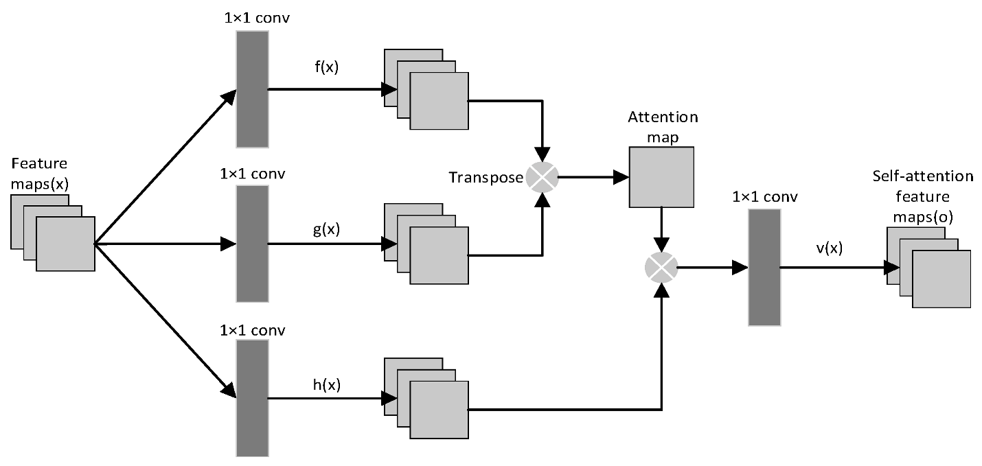
2.1. Self-Attention Mechanism
2.2. Wavelet Prediction and Reconstruction
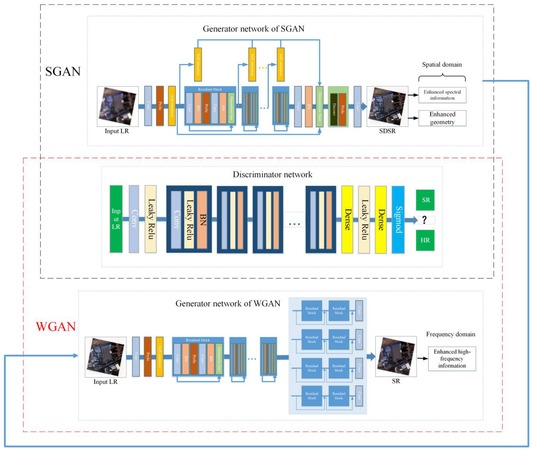
2.3. A Cascaded Spatial Frequency-Domain Generative Adversarial Network for SR: CSWGAN
2.4. Loss Function
2.4.1. Loss Function of SGAN
2.4.2. Loss Function of WGAN
2.5. Quantitative Evaluation Indices
3. Experiments
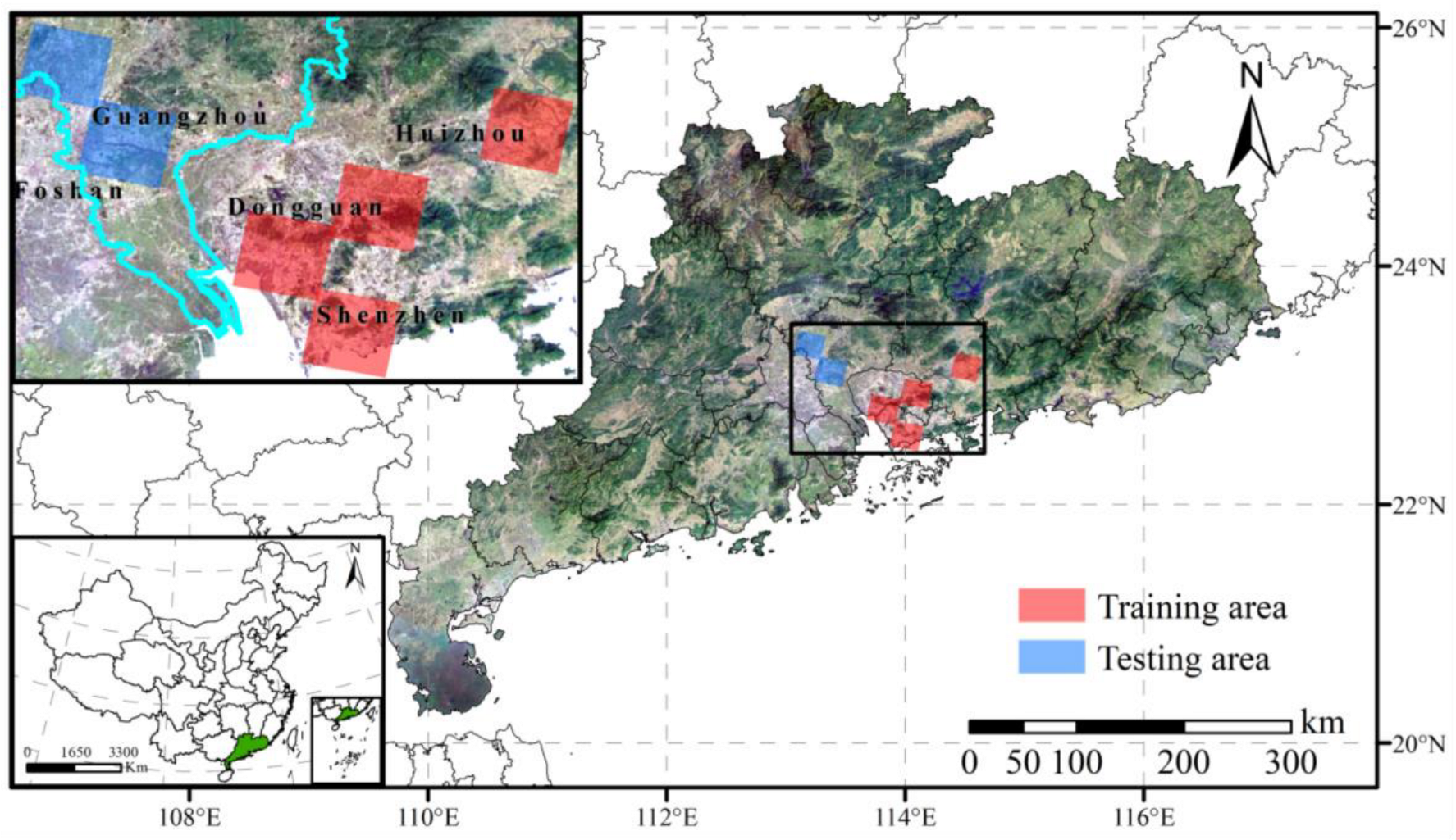
3.1. Datasets and Preprocessing
3.1.1. Real-World Multi-Sensor LR-HR Dataset: GF_Sen
3.1.2. UC_Merced
3.1.3. WHU-RS19
3.1.4. USC-SIPI
3.2. Training Details
4. Results
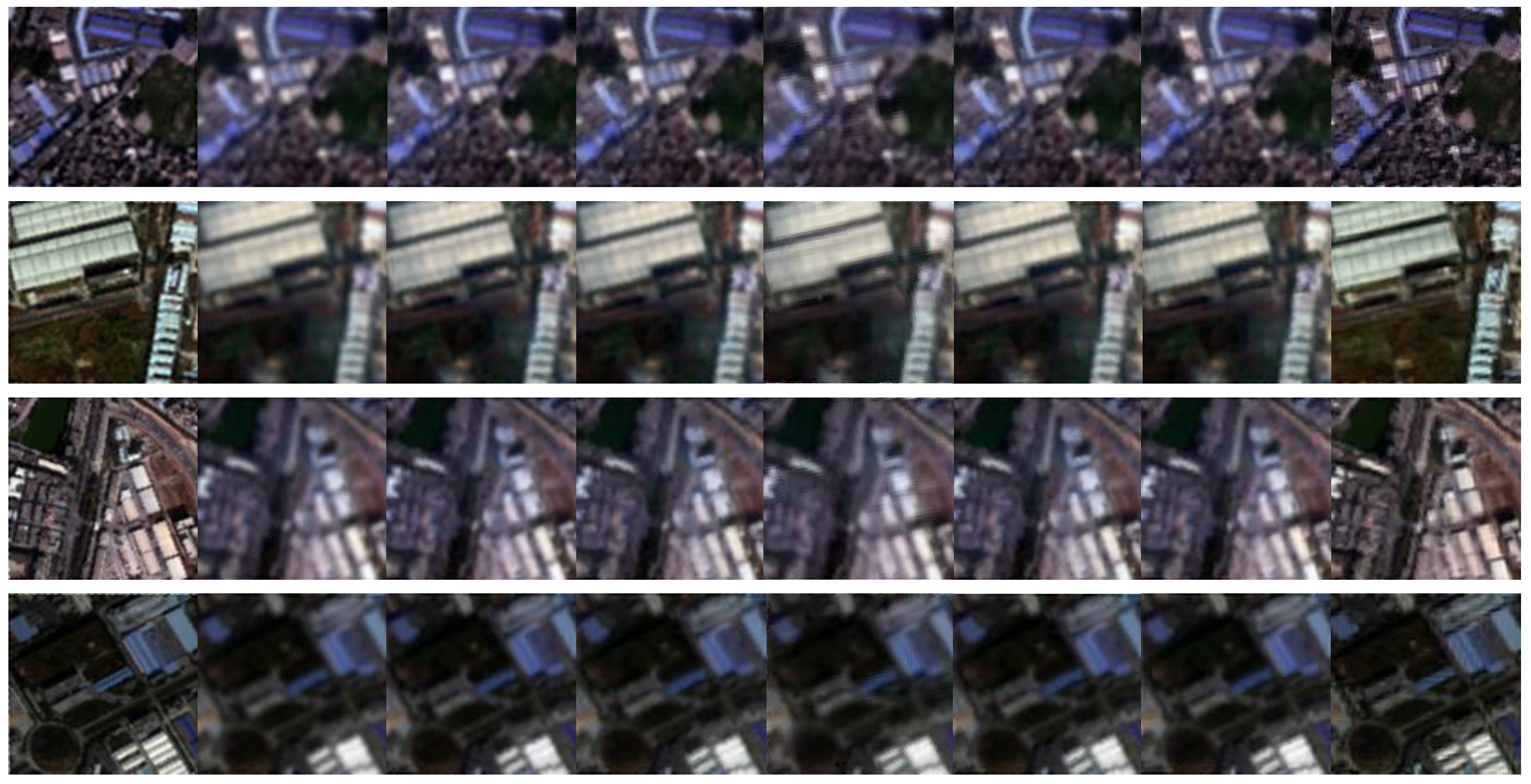
4.1. CSWGAN Evaluation
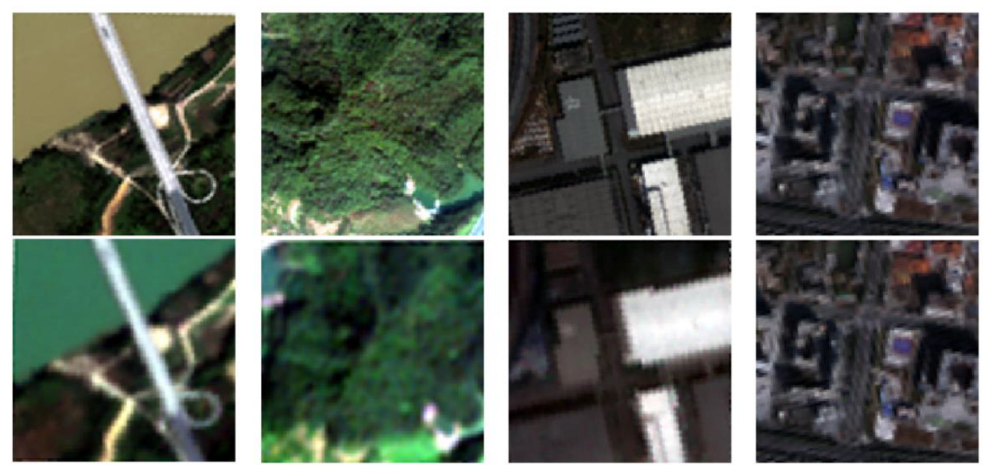
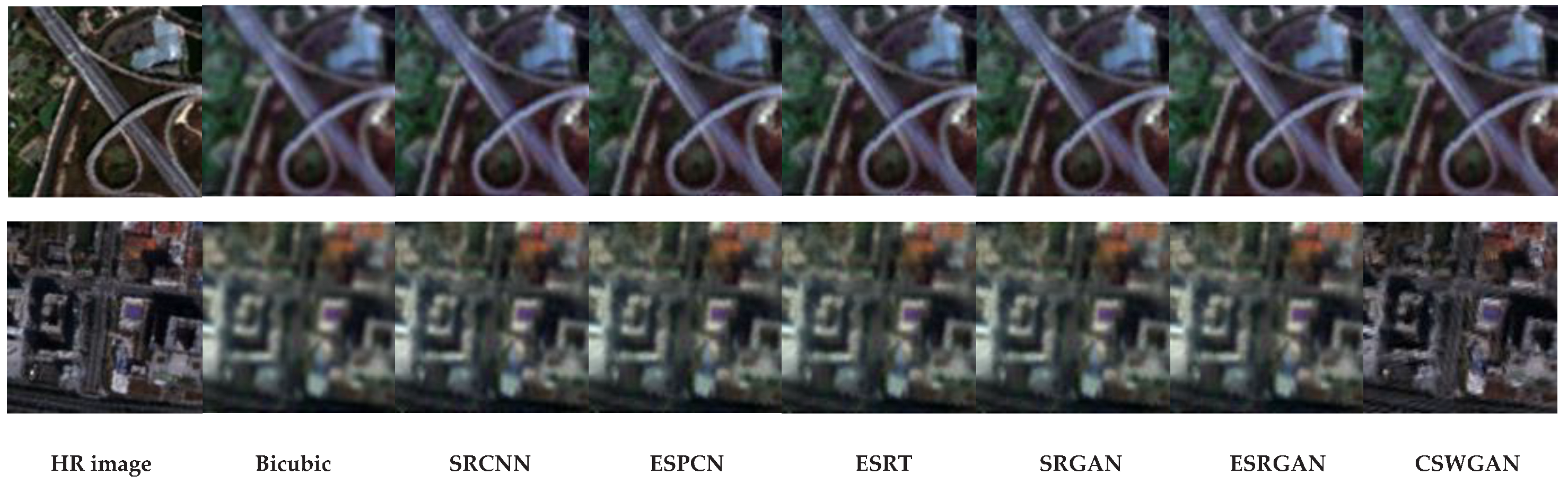
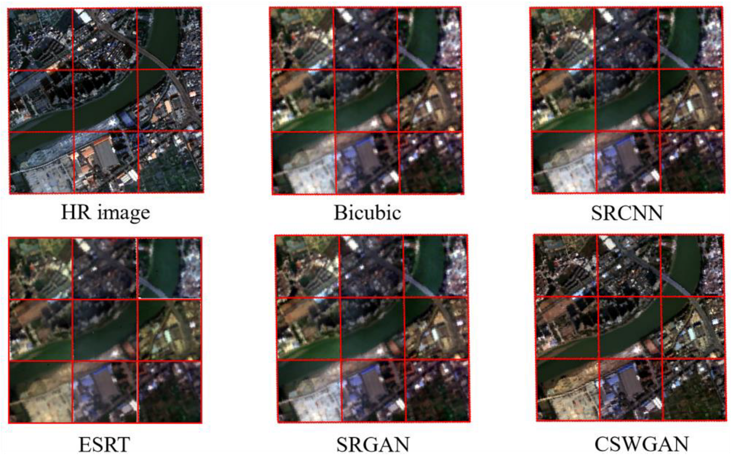
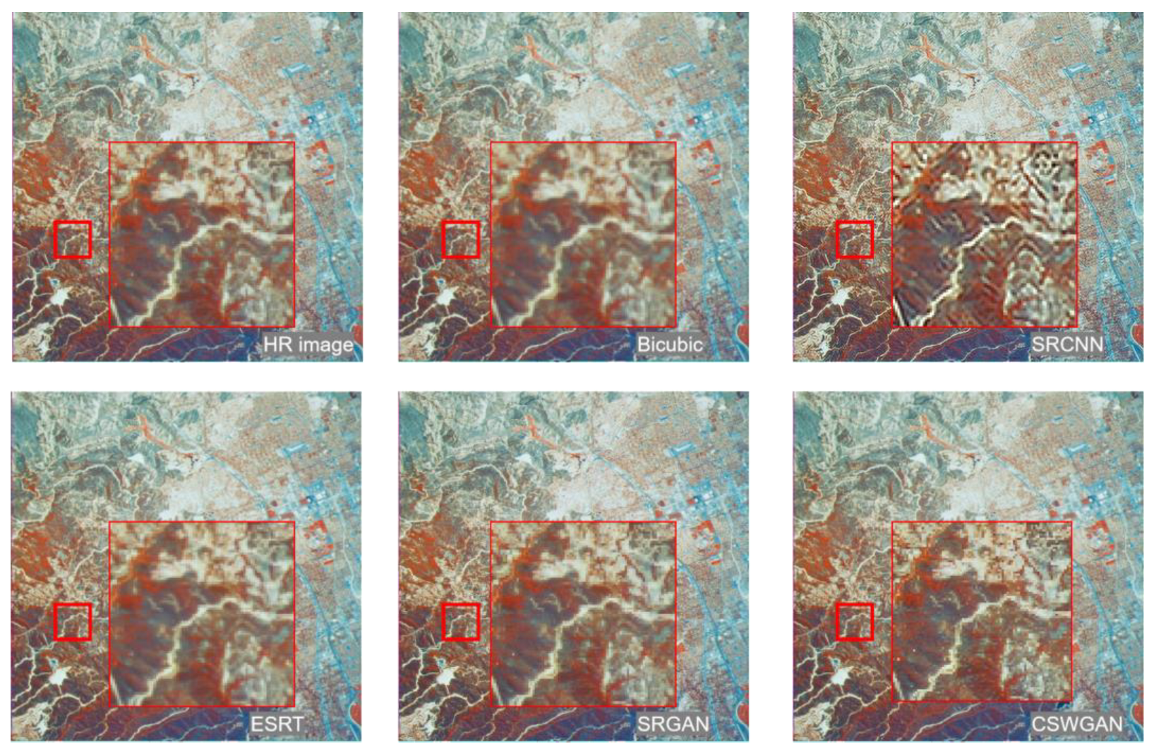
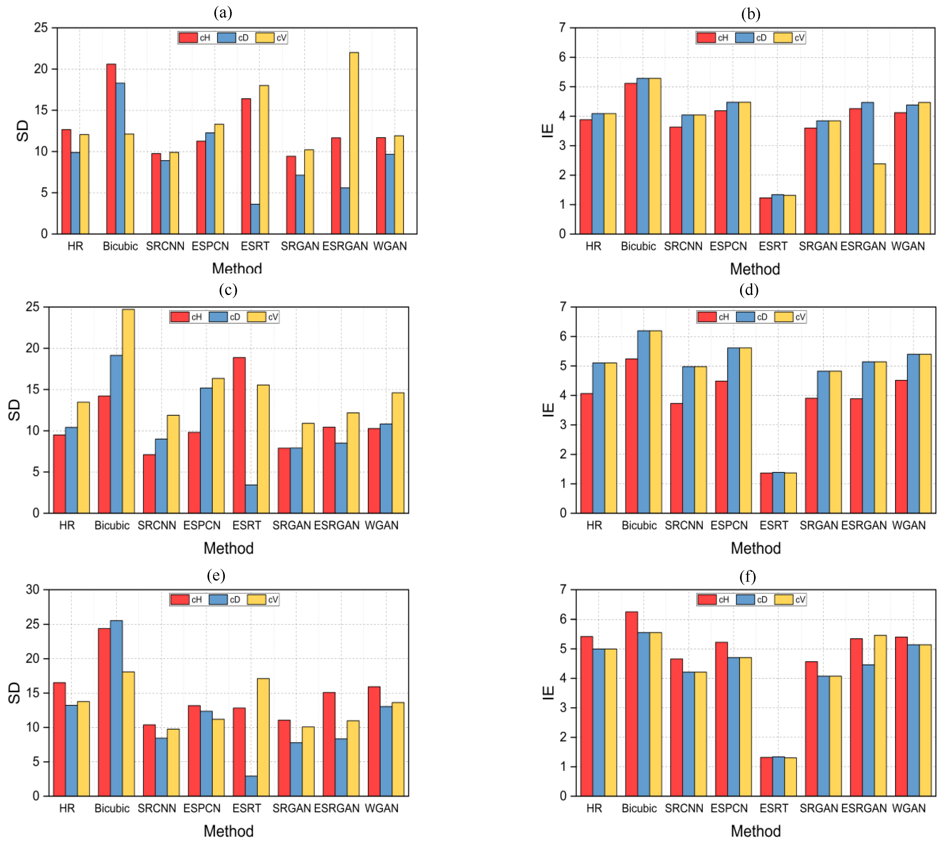
4.2. Comparison of CSWGAN SR on Multi-Sensor Scenes
4.3. Ablation Study
4.3.1. Evaluate the Performance of SGAN in Spatial Domain
4.3.2. Evaluate the Performance of WGAN in Frequency Domain
5. Discussion
5.1. Pros and Cons of CSWGAN
5.2. Application of GF_Sen
6. Conclusions
Author Contributions
Funding
Data Availability Statement
Acknowledgments
Conflicts of Interest
References
- Ienco, D.; Interdonato, R.; Gaetano, R.; Ho Tong Minh, D. Combining Sentinel-1 and Sentinel-2 Satellite Image Time Series for land cover mapping via a multi-source deep learning architecture. ISPRS J. Photogramm. Remote Sens. 2019, 158, 11–22. [Google Scholar] [CrossRef]
- Tang, X.; Bratley, K.H.; Cho, K.; Bullock, E.L.; Olofsson, P.; Woodcock, C.E. Near real-time monitoring of tropical forest disturbance by fusion of Landsat, Sentinel-2, and Sentinel-1 data. Remote Sens. Environ. 2023, 294, 113626. [Google Scholar] [CrossRef]
- Pelletier, F.; Cardille, J.A.; Wulder, M.A.; White, J.C.; Hermosilla, T. Inter- and intra-year forest change detection and monitoring of aboveground biomass dynamics using Sentinel-2 and Landsat. Remote Sens. Environ. 2024, 301, 113931. [Google Scholar] [CrossRef]
- Hafner, S.; Ban, Y.; Nascetti, A. Unsupervised domain adaptation for global urban extraction using Sentinel-1 SAR and Sentinel-2 MSI data. Remote Sens. Environ. 2022, 280, 113192. [Google Scholar] [CrossRef]
- Zhou, H.; Liu, S.; Mo, X.; Hu, S.; Zhang, L.; Ma, J.; Bandini, F.; Grosen, H.; Bauer-Gottwein, P. Calibrating a hydrodynamic model using water surface elevation determined from ICESat-2 derived cross-section and Sentinel-2 retrieved sub-pixel river width. Remote Sens. Environ. 2023, 298, 113796. [Google Scholar] [CrossRef]
- Ren, B.; Ma, S.; Hou, B.; Hong, D.; Chanussot, J.; Wang, J.; Jiao, L. A dual-stream high resolution network: Deep fusion of GF-2 and GF-3 data for land cover classification. Int. J. Appl. Earth Obs. Geoinf. 2022, 112, 102896. [Google Scholar] [CrossRef]
- Wu, Q.; Zhong, R.; Zhao, W.; Song, K.; Du, L. Land-cover classification using GF-2 images and airborne lidar data based on Random Forest. Int. J. Remote Sens. 2018, 40, 2410–2426. [Google Scholar] [CrossRef]
- Farsiu, S.; Robinson, D.; Elad, M.; Milanfar, P. Advances and challenges in super-resolution. Int. J. Imaging Syst. Technol. 2004, 14, 47–57. [Google Scholar] [CrossRef]
- Liu, Z.; Feng, R.; Wang, L.; Han, W.; Zeng, T. Dual Learning-Based Graph Neural Network for Remote Sensing Image Super-Resolution. IEEE Trans. Geosci. Remote Sens. 2022, 60, 1–14. [Google Scholar] [CrossRef]
- Keys, R. Cubic convolution interpolation for digital image processing. IEEE Trans. Acoust. Speech Signal Process. 1981, 29, 1153–1160. [Google Scholar] [CrossRef]
- Kim, J.; Lee, J.K.; Lee, K.M. Accurate Image Super-Resolution Using Very Deep Convolutional Networks. In Proceedings of the 2016 IEEE Conference on Computer Vision and Pattern Recognition (CVPR), Las Vegas, NV, USA, 27–30 June 2016; pp. 1646–1654. [Google Scholar]
- Pashaei, M.; Starek, M.J.; Kamangir, H.; Berryhill, J. Deep Learning-Based Single Image Super-Resolution: An Investigation for Dense Scene Reconstruction with UAS Photogrammetry. Remote Sens. 2020, 12, 1757. [Google Scholar] [CrossRef]
- Huan, H.; Li, P.; Zou, N.; Wang, C.; Xie, Y.; Xie, Y.; Xu, D. End-to-End Super-Resolution for Remote-Sensing Images Using an Improved Multi-Scale Residual Network. Remote Sens. 2021, 13, 666. [Google Scholar] [CrossRef]
- Dong, R.; Mou, L.; Zhang, L.; Fu, H.; Zhu, X.X. Real-world remote sensing image super-resolution via a practical degradation model and a kernel-aware network. ISPRS J. Photogramm. Remote Sens. 2022, 191, 155–170. [Google Scholar] [CrossRef]
- Panagiotopoulou, A.; Grammatikopoulos, L.; Charou, E.; Bratsolis, E.; Petrogonas, J. Very Deep Super-Resolution of Remotely Sensed Images with Mean Square Error and Var-norm Estimators as Loss Functions. arXiv 2020, arXiv:2007.15417. [Google Scholar]
- Wang, X.; Wu, Y.; Ming, Y.; Lv, H. Remote Sensing Imagery Super Resolution Based on Adaptive Multi-Scale Feature Fusion Network. Sensors 2020, 20, 1142. [Google Scholar] [CrossRef] [PubMed]
- Wang, Y.; Shao, Z.; Lu, T.; Liu, L.; Huang, X.; Wang, J.; Jiang, K.; Zeng, K. A lightweight distillation CNN-transformer architecture for remote sensing image super-resolution. Int. J. Digit. Earth 2023, 16, 3560–3579. [Google Scholar] [CrossRef]
- Dong, C.; Loy, C.C.; He, K.; Tang, X. Image Super-Resolution Using Deep Convolutional Networks. IEEE Trans. Pattern Anal. Mach. Intell. 2016, 38, 295–307. [Google Scholar] [CrossRef] [PubMed]
- Shi, W.; Caballero, J.; Huszár, F.; Totz, J.; Aitken, A.P.; Bishop, R.; Rueckert, D.; Wang, Z. Real-Time Single Image and Video Super-Resolution Using an Efficient Sub-Pixel Convolutional Neural Network. In Proceedings of the 2016 IEEE Conference on Computer Vision and Pattern Recognition (CVPR), Las Vegas, NV, USA, 27–30 June 2016; pp. 1874–1883. [Google Scholar]
- Lu, T.; Wang, J.; Zhang, Y.; Wang, Z.; Jiang, J. Satellite Image Super-Resolution via Multi-Scale Residual Deep Neural Network. Remote Sens. 2019, 11, 1588. [Google Scholar] [CrossRef]
- Pan, Z.; Ma, W.; Guo, J.; Lei, B. Super-Resolution of Single Remote Sensing Image Based on Residual Dense Backprojection Networks. IEEE Trans. Geosci. Remote Sens. 2019, 57, 7918–7933. [Google Scholar] [CrossRef]
- Ao, Z.; Wu, F.; Hu, S.; Sun, Y.; Su, Y.; Guo, Q.; Xin, Q. Automatic segmentation of stem and leaf components and individual maize plants in field terrestrial LiDAR data using convolutional neural networks. Crop J. 2022, 10, 1239–1250. [Google Scholar] [CrossRef]
- Johnson, J.; Alahi, A.; Fei-Fei, L. Perceptual Losses for Real-Time Style Transfer and Super-Resolution. In Proceedings of the Computer Vision—ECCV 2016, Cham, Switzerland, 8–16 October 2016; pp. 694–711. [Google Scholar]
- Mathieu, M.; Couprie, C.; Lecun, Y. Deep multi-scale video prediction beyond mean square error. arXiv 2016, arXiv:1511.05440. [Google Scholar]
- Guo, D.; Xia, Y.; Xu, L.; Li, W.; Luo, X. Remote sensing image super-resolution using cascade generative adversarial nets. Neurocomputing 2021, 443, 117–130. [Google Scholar] [CrossRef]
- Ledig, C.; Theis, L.; Huszár, F.; Caballero, J.; Cunningham, A.; Acosta, A.; Aitken, A.; Tejani, A.; Totz, J.; Wang, Z.; et al. Photo-Realistic Single Image Super-Resolution Using a Generative Adversarial Network. In Proceedings of the 2017 IEEE Conference on Computer Vision and Pattern Recognition (CVPR), Honolulu, HI, USA, 21–26 July 2017; pp. 105–114. [Google Scholar]
- Wang, X.; Yu, K.; Wu, S.; Gu, J.; Liu, Y.; Dong, C.; Qiao, Y.; Loy, C.C. ESRGAN: Enhanced Super-Resolution Generative Adversarial Networks. In Proceedings of the Computer Vision—ECCV 2018 Workshops, Cham, Switzerland, 8–14 September 2019; pp. 63–79. [Google Scholar]
- Peng, D.; Yang, W.; Liu, C.; Lü, S. SAM-GAN: Self-Attention supporting Multi-stage Generative Adversarial Networks for text-to-image synthesis. Neural Netw. 2021, 138, 57–67. [Google Scholar] [CrossRef] [PubMed]
- Zong, L.; Chen, L. Single Image Super-Resolution Based on Self-Attention. In Proceedings of the 2019 IEEE International Conference on Unmanned Systems and Artificial Intelligence (ICUSAI), Xi’an, China, 22–24 November 2019; pp. 56–60. [Google Scholar]
- Lu, Z.; Liu, H.; Li, J.; Zhang, L. Efficient Transformer for Single Image Super-Resolution. arXiv 2021, arXiv:2108.11084. [Google Scholar]
- Li, J.; Meng, Y.; Tao, C.; Zhang, Z.; Yang, X.; Wang, Z.; Wang, X.; Li, L.; Zhang, W. ConvFormerSR: Fusing Transformers and Convolutional Neural Networks for Cross-Sensor Remote Sensing Imagery Super-Resolution. IEEE Trans. Geosci. Remote Sens. 2024, 62, 1–15. [Google Scholar] [CrossRef]
- Chan, R.; Chan, T.; Shen, L.; Shen, Z. Wavelet Algorithms for High-Resolution Image Reconstruction. SIAM J. Sci. Comput. 2004, 24, 1408–1432. [Google Scholar] [CrossRef]
- Kinebuchi, K.; Muresan, D.D.; Parks, T.W. Image interpolation using wavelet based hidden Markov trees. In Proceedings of the Acoustics, Speech, and Signal Processing, 2001 on IEEE International Conference, Salt Lake City, UT, USA, 7–11 May 2001; Volume 3, pp. 1957–1960. [Google Scholar]
- Zhou, R.; Lahoud, F.; Helou, M.; Süsstrunk, S. A comparative study on wavelets and residuals in deep super resolution. Electron. Imaging 2019, 2019, 135-1–135-7. [Google Scholar] [CrossRef]
- Guo, T.; Mousavi, H.S.; Vu, T.H.; Monga, V. Deep Wavelet Prediction for Image Super-Resolution. In Proceedings of the 2017 IEEE Conference on Computer Vision and Pattern Recognition Workshops (CVPRW), Honolulu, HI, USA, 21–26 July 2017; pp. 1100–1109. [Google Scholar]
- Xue, S.; Qiu, W.; Liu, F.; Jin, X. Wavelet-based residual attention network for image super-resolution. Neurocomputing 2020, 382, 116–126. [Google Scholar] [CrossRef]
- Feng, X.; Zhang, W.; Su, X.; Xu, Z. Optical Remote Sensing Image Denoising and Super-Resolution Reconstructing Using Optimized Generative Network in Wavelet Transform Domain. Remote Sens. 2021, 13, 1858. [Google Scholar] [CrossRef]
- Huang, H.; He, R.; Sun, Z.; Tan, T. Wavelet-SRNet: A Wavelet-Based CNN for Multi-scale Face Super Resolution. In Proceedings of the 2017 IEEE International Conference on Computer Vision (ICCV), Venice, Italy, 22–29 October 2017; pp. 1698–1706. [Google Scholar]
- Yang, Y.; Newsam, S. Bag-of-visual-words and spatial extensions for land-use classification. In Proceedings of the 18th SIGSPATIAL International Conference on Advances in Geographic Information Systems, San Jose, CA, USA, 2–5 November 2010; pp. 270–279. [Google Scholar]
- Sheng, G.; Yang, W.; Xu, T.; Sun, H. High-resolution satellite scene classification using a sparse coding based multiple feature combination. Int. J. Remote Sens. 2012, 33, 2395–2412. [Google Scholar] [CrossRef]
- Lim, B.; Son, S.; Kim, H.; Nah, S.; Lee, K.M. Enhanced Deep Residual Networks for Single Image Super-Resolution. In Proceedings of the 2017 IEEE Conference on Computer Vision and Pattern Recognition Workshops (CVPRW), Honolulu, HI, USA, 21–26 July 2017; pp. 1132–1140. [Google Scholar]
- Fernandez-Beltran, R.; Carmona, P.; Pla, F. Single-frame super-resolution in remote sensing: A practical overview. Int. J. Remote Sens. 2017, 38, 314–354. [Google Scholar] [CrossRef]
- Karathanassi, V.; Kolokousis, P.; Ioannidou, S. A comparison study on fusion methods using evaluation indicators. Int. J. Remote Sens. 2007, 28, 2309–2341. [Google Scholar] [CrossRef]
- Chen, Z.; Zhang, Y.; Gu, J.; Kong, L.; Yang, X.; Yu, F. Dual Aggregation Transformer for Image Super-Resolution. arXiv 2023, arXiv:2308.03364. [Google Scholar] [CrossRef]
- Li, B.; Li, X.; Zhu, H.; Jin, Y.; Feng, R.; Zhang, Z.; Chen, Z. SeD: Semantic-Aware Discriminator for Image Super-Resolution. arXiv 2024, arXiv:2402.19387. [Google Scholar]
- Gandikota, K.V.; Chandramouli, P. Text-guided Explorable Image Super-resolution. arXiv 2024, arXiv:2403.01124. [Google Scholar]
- Kendall, A.; Gal, Y.; Cipolla, R. Multi-Task Learning Using Uncertainty to Weigh Losses for Scene Geometry and Semantics. In Proceedings of the 2018 IEEE/CVF Conference on Computer Vision and Pattern Recognition, Salt Lake City, UT, USA, 18–23 June 2018. [Google Scholar]
- Yang, B.; Xiang, X.; Kong, W.; Peng, Y.; Yao, J. Adaptive multi-task learning using lagrange multiplier for automatic art analysis. Multimed. Tools Appl. 2022, 81, 3715–3733. [Google Scholar] [CrossRef]
- Sung Cheol, P.; Min Kyu, P.; Moon Gi, K. Super-resolution image reconstruction: A technical overview. IEEE Signal Process. Mag. 2003, 20, 21–36. [Google Scholar] [CrossRef]
- Shiklomanov, A.N.; Dietze, M.C.; Viskari, T.; Townsend, P.A.; Serbin, S.P. Quantifying the influences of spectral resolution on uncertainty in leaf trait estimates through a Bayesian approach to RTM inversion. Remote Sens. Environ. 2016, 183, 226–238. [Google Scholar] [CrossRef]
- Drusch, M.; Del Bello, U.; Carlier, S.; Colin, O.; Fernandez, V.; Gascon, F.; Hoersch, B.; Isola, C.; Laberinti, P.; Martimort, P.; et al. Sentinel-2: ESA’s Optical High-Resolution Mission for GMES Operational Services. Remote Sens. Environ. 2012, 120, 25–36. [Google Scholar] [CrossRef]
- Lanaras, C.; Bioucas-Dias, J.; Galliani, S.; Baltsavias, E.; Schindler, K. Super-resolution of Sentinel-2 images: Learning a globally applicable deep neural network. ISPRS J. Photogramm. Remote Sens. 2018, 146, 305–319. [Google Scholar] [CrossRef]
- Dong, X.; Wang, L.; Sun, X.; Jia, X.; Gao, L.; Zhang, B. Remote Sensing Image Super-Resolution Using Second-Order Multi-Scale Networks. IEEE Trans. Geosci. Remote Sens. 2021, 59, 3473–3485. [Google Scholar] [CrossRef]
- Zhu, X.; Helmer, E.; Gao, F.; Liu, D.; Chen, J.; Lefsky, M. A flexible spatiotemporal method for fusing satellite images with different resolutions. Remote Sens. Environ. 2016, 172, 165–177. [Google Scholar] [CrossRef]
- Zhang, H.; Sun, Y.; Shi, W.; Guo, D.; Zheng, N. An object-based spatiotemporal fusion model for remote sensing images. Eur. J. Remote Sens. 2021, 54, 86–101. [Google Scholar] [CrossRef]
- Li, J.; Li, Y.; He, L.; Chen, J.; Plaza, A. Spatio-temporal fusion for remote sensing data: An overview and new benchmark. Sci. China Inf. Sci. 2020, 63, 140301. [Google Scholar] [CrossRef]
- Wang, Q.; Atkinson, P.M. Spatio-temporal fusion for daily Sentinel-2 images. Remote Sens. Environ. 2018, 204, 31–42. [Google Scholar] [CrossRef]
- Fu, G.; Liu, C.; Zhou, R.; Sun, T.; Zhang, Q. Classification for High Resolution Remote Sensing Imagery Using a Fully Convolutional Network. Remote Sens. 2017, 9, 498. [Google Scholar] [CrossRef]
- Li, W.; He, C.; Fang, J.; Zheng, J.; Fu, H.; Yu, L. Semantic Segmentation-Based Building Footprint Extraction Using Very High-Resolution Satellite Images and Multi-Source GIS Data. Remote Sens. 2019, 11, 403. [Google Scholar] [CrossRef]
- Zheng, J.; Fu, H.; Li, W.; Wu, W.; Yu, L.; Yuan, S.; Tao, W.Y.W.; Pang, T.K.; Kanniah, K.D. Growing status observation for oil palm trees using Unmanned Aerial Vehicle (UAV) images. ISPRS J. Photogramm. Remote Sens. 2021, 173, 95–121. [Google Scholar] [CrossRef]
- Dong, R.; Li, C.; Fu, H.; Wang, J.; Li, W.; Yao, Y.; Gan, L.; Yu, L.; Gong, P. Improving 3-m Resolution Land Cover Mapping through Efficient Learning from an Imperfect 10-m Resolution Map. Remote Sens. 2020, 12, 1418. [Google Scholar] [CrossRef]


| Indicator | Formula | Remarks |
|---|---|---|
| / | ||
| X and Y correspond to the reconstructed image and the original image, c1 and c2 constants should be set to (K1L) and (K2L), respectively, where K1 and K2 are values close to 0, and L represents the image dynamic range. | ||
| N is the total number of pixels in each image, K is the number of bands. | ||
| / | ||
| F(i) represents the pixel value, represents the mean pixel value. | ||
| P(i) represents the probability of the pixel value. |
| Location | Sensor | Filename |
|---|---|---|
| Guangzhou | Sentinel-2 | L1C_T49QGF_A003347_20191002T030635 |
| Guangzhou | GaoFen-2 | GF2_PMS1_E113.2_N23.3_20191227_L1A0004507303 |
| Guangzhou | Sentinel-2 | L1C_T49QGF_A003347_20191002T030635 |
| Guangzhou | GaoFen-2 | GF2_PMS2_E113.4_N23.1_20191227_L1A0004505416 |
| Shenzhen | Sentinel-2 | L1C_T49QGF_A003347_20171027T030705 |
| Shenzhen | GaoFen-2 | GF2_PMS1_E113.8_N22.8_20171227_L1A0002883454 |
| Shenzhen | Sentinel-2 | L1C_T49QGF_A003347_20171027T030705 |
| Shenzhen | GaoFen-2 | GF2_PMS2_E114.0_N22.6_20171227_L1A0002883537 |
| Dongguan | Sentinel-2 | L1C_T49QHF_A003347_20171027T030705 |
| Dongguan | GaoFen-2 | GF2_PMS2_E114.1_N22.9_20171227_L1A0002883531 |
| Huizhou | Sentinel-2 | L1C_T50QKL_A007994_20170102T025445 |
| Huizhou | GaoFen-2 | GF2_PMS1_E114.5_N23.1_20161128_L1A0001994661 |
| Method | Trained on Simulated Dataset | Trained on GF_Sen Dataset | ||||||
|---|---|---|---|---|---|---|---|---|
| PSNR | SSIM | SAM | RMSE | PSNR | SSIM | SAM | RMSE | |
| Bicubic | 18.863 | 0.593 | 0.301 | 30.039 | ||||
| SRCNN | 17.975 | 0.506 | 0.284 | 28.506 | 18.191 | 0.512 | 0.316 | 30.553 |
| ESPCN | 18.006 | 0.612 | 0.302 | 29.864 | 18.266 | 0.582 | 0.303 | 29.864 |
| ESRT | 19.092 | 0.461 | 0.219 | 24.484 | 20.287 | 0.669 | 0.191 | 24.484 |
| SRGAN | 18.654 | 0.611 | 0.385 | 36.675 | 19.217 | 0.639 | 0.372 | 36.168 |
| ESRGAN | 18.975 | 0.621 | 0.286 | 28.948 | 19.458 | 0.647 | 0.338 | 33.060 |
| CSWGAN | 23.350 | 0.853 | 0.192 | 17.781 | 24.335 | 0.828 | 0.178 | 15.356 |
| Type | psnr_A | ssim_A | psnr_B | ssim_B | psnr_C | ssim_C | psnr_D | ssim_D | psnr_E | ssim_E | psnr_F | ssim_F | psnr_G | ssim_G |
|---|---|---|---|---|---|---|---|---|---|---|---|---|---|---|
| Airport | 32.054 | 0.925 | 32.623 | 0.944 | 32.908 | 0.941 | 25.559 | 0.769 | 30.309 | 0.907 | 29.928 | 0.859 | 32.393 | 0.947 |
| Beach | 36.257 | 0.987 | 37.429 | 0.992 | 34.400 | 0.977 | 42.324 | 0.969 | 36.165 | 0.976 | 37.341 | 0.922 | 45.142 | 0.993 |
| Bridge | 34.183 | 0.942 | 34.789 | 0.942 | 34.276 | 0.944 | 30.548 | 0.875 | 34.74 | 0.957 | 31.463 | 0.927 | 34.859 | 0.958 |
| Commercial area | 27.621 | 0.887 | 28.946 | 0.919 | 28.862 | 0.909 | 22.692 | 0.698 | 26.112 | 0.870 | 27.193 | 0.845 | 28.967 | 0.920 |
| Forest | 32.113 | 0.884 | 33.362 | 0.923 | 31.908 | 0.901 | 26.599 | 0.666 | 30.180 | 0.855 | 30.408 | 0.868 | 32.555 | 0.910 |
| Industrial area | 30.489 | 0.915 | 31.379 | 0.938 | 31.214 | 0.932 | 24.374 | 0.738 | 28.488 | 0.896 | 19.350 | 0.661 | 31.620 | 0.941 |
| Meadow | 42.375 | 0.955 | 40.131 | 0.968 | 39.402 | 0.963 | 34.17 | 0.84 | 41.052 | 0.946 | 40.512 | 0.918 | 41.316 | 0.963 |
| Mountain area | 27.368 | 0.827 | 28.490 | 0.877 | 27.758 | 0.862 | 23.529 | 0.613 | 26.438 | 0.819 | 27.443 | 0.845 | 28.152 | 0.870 |
| Park | 33.142 | 0.904 | 33.987 | 0.929 | 33.613 | 0.925 | 26.274 | 0.73 | 31.697 | 0.895 | 31.336 | 0.839 | 34.084 | 0.932 |
| Parking | 30.993 | 0.947 | 32.261 | 0.965 | 31.756 | 0.962 | 24.27 | 0.801 | 27.869 | 0.922 | 29.084 | 0.917 | 32.140 | 0.958 |
| Pond | 46.854 | 0.984 | 42.743 | 0.981 | 39.981 | 0.955 | 29.934 | 0.848 | 47.010 | 0.984 | 39.921 | 0.967 | 44.387 | 0.981 |
| Port | 32.247 | 0.940 | 33.063 | 0.954 | 32.002 | 0.944 | 24.906 | 0.808 | 30.290 | 0.927 | 31.742 | 0.969 | 33.151 | 0.954 |
| Train station | 28.084 | 0.873 | 30.210 | 0.926 | 29.450 | 0.917 | 23.902 | 0.669 | 25.926 | 0.847 | 27.002 | 0.898 | 30.274 | 0.930 |
| Residential area | 27.756 | 0.907 | 29.345 | 0.934 | 29.161 | 0.924 | 22.434 | 0.725 | 25.677 | 0.883 | 28.249 | 0.863 | 29.395 | 0.935 |
| River | 32.266 | 0.898 | 33.105 | 0.921 | 32.550 | 0.918 | 27.148 | 0.746 | 30.587 | 0.881 | 30.077 | 0.898 | 32.608 | 0.929 |
| Viaduct | 28.330 | 0.896 | 29.887 | 0.930 | 29.955 | 0.924 | 23.497 | 0.705 | 30.255 | 0.926 | 26.361 | 0.874 | 30.477 | 0.935 |
| Method | Trained on Simulated Dataset | Trained on GF_Sen Dataset | ||||||
|---|---|---|---|---|---|---|---|---|
| PSNR | SSIM | SD | IE | PSNR | SSIM | SD | IE | |
| Bicubic | 18.863 | 0.593 | 61.411 | 6.699 | ||||
| SRCNN | 17.975 | 0.506 | 53.999 | 5.757 | 18.191 | 0.512 | 59.795 | 6.281 |
| ESPCN | 18.006 | 0.612 | 59.257 | 6.331 | 18.266 | 0.582 | 60.257 | 6.447 |
| ESRT | 19.092 | 0.461 | 63.2142 | 6.3867 | 19.287 | 0.669 | 64.0794 | 6.162 |
| SRGAN | 18.654 | 0.611 | 58.713 | 6.416 | 19.217 | 0.639 | 63.049 | 6.663 |
| ESRGAN | 18.975 | 0.621 | 62.588 | 6.502 | 19.458 | 0.647 | 63.280 | 6.802 |
| SGAN | 19.452 | 0.641 | 63.893 | 6.820 | 19.552 | 0.645 | 64.593 | 6.833 |
| Method | Trained on Simulated Dataset | Trained on GF_Sen Dataset | ||||||
|---|---|---|---|---|---|---|---|---|
| PSNR | SSIM | SAM | RMSE | PSNR | SSIM | SAM | RMSE | |
| Bicubic | 18.863 | 0.593 | 0.301 | 30.039 | ||||
| SRCNN | 17.975 | 0.506 | 0.284 | 28.506 | 18.191 | 0.512 | 0.316 | 30.553 |
| ESPCN | 18.006 | 0.612 | 0.302 | 29.864 | 18.266 | 0.582 | 0.303 | 29.864 |
| ESRT | 19.092 | 0.461 | 0.219 | 25.322 | 20.287 | 0.669 | 0.191 | 24.484 |
| SRGAN | 18.654 | 0.611 | 0.385 | 36.675 | 19.217 | 0.639 | 0.372 | 36.168 |
| ESRGAN | 18.975 | 0.621 | 0.286 | 28.948 | 19.458 | 0.647 | 0.338 | 33.060 |
| WGAN | 22.142 | 0.836 | 0.178 | 18.217 | 23.564 | 0.855 | 0.188 | 17.421 |
Disclaimer/Publisher’s Note: The statements, opinions and data contained in all publications are solely those of the individual author(s) and contributor(s) and not of MDPI and/or the editor(s). MDPI and/or the editor(s) disclaim responsibility for any injury to people or property resulting from any ideas, methods, instructions or products referred to in the content. |
© 2024 by the authors. Licensee MDPI, Basel, Switzerland. This article is an open access article distributed under the terms and conditions of the Creative Commons Attribution (CC BY) license (https://creativecommons.org/licenses/by/4.0/).
Share and Cite
Wang, X.; Ao, Z.; Li, R.; Fu, Y.; Xue, Y.; Ge, Y. Super-Resolution Image Reconstruction Method between Sentinel-2 and Gaofen-2 Based on Cascaded Generative Adversarial Networks. Appl. Sci. 2024, 14, 5013. https://doi.org/10.3390/app14125013
Wang X, Ao Z, Li R, Fu Y, Xue Y, Ge Y. Super-Resolution Image Reconstruction Method between Sentinel-2 and Gaofen-2 Based on Cascaded Generative Adversarial Networks. Applied Sciences. 2024; 14(12):5013. https://doi.org/10.3390/app14125013
Chicago/Turabian StyleWang, Xinyu, Zurui Ao, Runhao Li, Yingchun Fu, Yufei Xue, and Yunxin Ge. 2024. "Super-Resolution Image Reconstruction Method between Sentinel-2 and Gaofen-2 Based on Cascaded Generative Adversarial Networks" Applied Sciences 14, no. 12: 5013. https://doi.org/10.3390/app14125013
APA StyleWang, X., Ao, Z., Li, R., Fu, Y., Xue, Y., & Ge, Y. (2024). Super-Resolution Image Reconstruction Method between Sentinel-2 and Gaofen-2 Based on Cascaded Generative Adversarial Networks. Applied Sciences, 14(12), 5013. https://doi.org/10.3390/app14125013