1. Introduction
Geographic Information Science is now recognized as a domain on its own that is widely used to solve complex geographical problems [
1]. It can be viewed as a combination of scientific principles, methods, analysis, systems, and procedures that can be applied to many environmental and urban management and forecasting studies. It helps to better understand the evolution of a given region of interest and the changes that impact geographical objects (e.g., roads, parcels, buildings, etc.) associated with thematic, spatial, and/or temporal features.
GIS is appropriate when compiling and answering questions on thematic (e.g., what is the ID of an object?), spatial (e.g., where is an object?), temporal (e.g., when did a change happen?), spatio-temporal (e.g., where was an object at a specific date?), historical (e.g., track the evolution of an object) topological (e.g., what are the objects that touch a given object?), and synchronizing types (e.g., what are the objects created during the lifespan of an object) [
2]. GIS allows the representation and manipulation of events and processes that may occur in a given region. As many geographical objects can be represented at different scales, representing spatio-temporal data should be considered as a multi-representation problem [
3]. A given real-world object can be represented and viewed in different ways, implying several levels of detail for its thematic and spatial properties that should be studied. A complete modeling methodology must be applied to reach the full benefits of GIS. This methodology should start with analyzing and modeling the case study and extend to data manipulation and visualization tasks.
Most GIS predominantly rely on logical models for representation data with spatio-temporal features. This practice can be insufficient when addressing complex case studies [
4]. These complex scenarios require conceptual models offering a clearer and more comprehensive data representation, particularly when data needs to be shared and comprehended across different organizations. To this end, specific conceptual modeling approaches for spatio-temporal data have been developed and are valuable for describing the complexity of a specific application of interest as the concepts behind them are easy to understand and apply for non-database specialists [
5]. They are well-suited for representing geographical objects within a specific geographical area, such as a city, and excel in showing the spatial and/or temporal characteristics of various elements like cadasters, buildings, roads, rivers, and lakes. Furthermore, they capture topological relationships, including for example, “inclusion” relationships between buildings and cadasters. Nonetheless, these conceptual models fall short when tasked with describing the intricate data management processes within an organization, particularly when data management tasks take precedence. Consider, for instance, the management of road traffic in this city as an illustrative example. This process involves identifying critical road sections, analyzing traffic congestion during specific events, and formulating evacuation plans for emergency situations. Although this process comprises interconnected events closely related to the physical entities modeled (such as roads, intersections, and bridges), an accurate representation of it cannot be effectively achieved using the conceptual models for data alone.
Indeed, it is important to seamlessly incorporate both the representation of real-world objects and management concerns into the realm of conceptual modeling [
4]. However, the convergence of these two modeling approaches into a unified and comprehensive spatio-temporal modeling framework remains a challenge. Consequently, our research is steadfastly dedicated to overcoming this challenge by crafting a geographical modeling framework that harmoniously accommodates both perspectives within a complementary framework. This framework is designed to depict real-world geographical objects while also illuminating their associations with various management tasks. By combining a conceptual spatio-temporal model with business process diagrams, we deliver a solution that gives the user the ability to clearly illustrate, track, and explain how the geographical characteristics of objects are and will be impacted in response to well-defined external processes.
In this paper, we present a comprehensive GIS framework that leverages the synergies between MADS (Modeling of Application Data with Spatio-Temporal features) and BPMN (Business Process Model Notation). Geographical data are conceptually represented using MADS, while associated management processes are conceptually described in BPMN. The MADS diagram forms the information model of related BPMN process models. This conceptual separation between objects and processes is novel in the domain of geographical data and vital for maintaining flexibility and adaptability as requirements evolve.
The MADS-based conceptual model in our approach is thoughtfully designed to be shared among a wide array of organizations, each with distinct BPMN-based business models. This thoughtful design allows it to seamlessly integrate with various business models, thereby fostering data reuse, promoting extensibility, and establishing a clear separation between data and process modeling.
The overall conceptual framework is implemented and used in the relational database management system PostgreSQL/PostGIS. MADS diagrams are first encoded as a relational database; therefore, the BPMN diagram boosted with OCL logical rules is encoded as a Petri net to define the link with PostgreSQL/PostGIS [
6,
7]. Indeed, to ensure the executability of our framework, OCL (Object Constraint Language) contracts are added to BPMN to specify which SQL statements must be applied to the database when an activity is executed [
8]. Petri nets are formal tools that follow rigorous mathematical principles (e.g., place, transition, input, and output), which we have chosen to formalize the control flow of annotated BPMN models [
9]. The logical implementation of the conceptual and business model into PostgreSQL/PostGIS, meticulously adhering to standard SQL practices, serves as a practical demonstration of the adaptability of our framework to handle data on a larger organizational scale.
The rest of the paper is structured as follows. After a quick review and comparison of existing conceptual models,
Section 3 introduces the main principles behind the MADS and BPMN models. In
Section 4, we discuss the technique and benefits of merging MADS and BPMN. In
Section 5, we apply our approach to an illustrative case study. Lastly, we give concluding remarks in
Section 6.
2. Geographical Database Modeling Background
A geographic database should take into consideration the spatial and temporal features associated with the represented data to reflect their actual states and evolutions over time. Many spatio-temporal data models have been proposed at the most abstract level, from object-based (vector) to field-based (raster) views of space [
10]. Time has been mainly developed at the database level using several complementary dimensions: valid time (i.e., indicating the time when an event occurs in the real world), transaction time (i.e., indicating the time when an event is recorded in a database), and user time (i.e., indicating the dates for specific events registered by users). Additionally, spatio-temporal data analysis has embraced spatio-temporal graph databases, and emerging technologies like spatio-temporal graph neural networks, offering innovative ways to address complex spatial and temporal relationships [
11,
12]. However, especially valuable at the logical level, not so easily abstracted at the conceptual level, especially when the objective is to model a given application of interest.
2.1. Conceptual Spatio-Temporal Data Modeling Approaches
Data modeling ensures the transition from the real world to the digital world. Usually, a modeling approach includes a stage of perception of the real world, followed by a sequence of three modeling levels (conceptual, logical, and physical). The conceptual level is a graphical representation of the data within a formal framework that is easily understandable for schematizing the content of information. Entity-Association models (EA) [
13], and object-oriented models like UML [
14] are the ones most used.
The GIS community has progressively introduced conceptual models for integrating the spatio-temporal dimensions within these EA and object-oriented approaches. Spatio-temporal conceptual modeling has many advantages: it provides user concepts that enable the implementation of readable and easy-to-understand data schemes, and it is independent of computer implementation. In addition, it favors the exchange of information between partners of different organizations, and it is transformed using a well-defined set of transformation rules into computer languages [
5]. Indeed, when designing spatio-temporal conceptual models, some specific requirements should be considered along with usual data modeling requirements. Conceptual spatio-temporal models should allow the representation of geographical objects and events with their 2D and 3D spatial and temporal characteristics and interactions according to different scales and perspectives [
10,
15]:
STUML [
16], Perceptory [
17], Profiles-UML [
18], aand MADS are popular models based on extensions for Entity-Association (EA) and Object-Oriented (OO) approaches to modeling geographical data. MADS integrates basic spatial and temporal types (i.e., point, line, simple area, instant, interval) and homogeneous sets (point set, line set, instants set, etc.) and offers complete orthogonality between the thematic, spatial, and temporal dimensions. These dimensions can be freely assigned to classes, attributes, and associations. This model provides a graphical language and pictograms to support topological and temporal relationships between objects. MADS explicitly supports multiple representations and has a hierarchy of generic spatial and temporal types and intuitive visual notations. MADS has been extended to support spatio-temporal processes [
19,
20] and to support 2.5, 2.75, and 3D spatial representations [
21]. The spatio-temporal processes (STP) modeling approach provides a complementary approach to MADS with conceptual support for the representation of spatio-temporal processes [
20]. Events are defined through processes that transform entities. It proposes a typology of three main classes of basic STPs: (i) evolution of a single entity (basic changes, transformations, and movements); (ii) functional relationships between entities (replacement and diffusion processes); and (iii) evolution of spatial structures affecting several entities [
5]. STPs are defined as object types in a database. Thus, actual processes are materialized “as object instances of the appropriate type”. STPs can be specialized as needed for the users’ needs. This offers a clear enumeration and definition of the processes involved in the dynamics of geographic phenomena [
5]. MADS was carefully selected as the foundation for our approach due to its numerous studies that have highlighted its exceptional clarity and readability. In comparison to other models, MADS possesses a multitude of advantages specifically tailored to meet the design requirements of spatio-temporal data [
10,
21,
22,
23]. Nevertheless, while MADS’s STP enhancement showcases intriguing features [
20], it fails in ensuring the crucial independence between data and process modeling, thus limiting the model’s extensibility and reusability. To overcome this challenge, we have integrated BPMN as a complementary tool to MADS in order to address the management process dimension [
21].
2.2. Business Process Modeling
A Business process model is defined by a sequence of events and actions that lead to a defined “state of affairs” with a clear beginning and end [
24]. It deals with data and events, takes inputs, and gives outputs. Business processes represent a strategic and critical intellectual asset that needs to be understood and proactively managed [
25,
26]. Different organizations have proposed several standards for business process modeling and management (OMG, BPMI, OASIS, IMB, W3C, etc.), as well as several research approaches, such as event-driven process chains [
27], BPM [
28], BPMN [
24,
29] and UML-activity diagrams [
30].
Among many approaches, BPMN and UML activity diagrams are the most popular business process models [
29,
31,
32]. A UML Activity diagram describes the dynamic aspects of a given system. It can be defined as an improved version of a flow chart that models the flow between activities. The flow from one activity to another can be concurrent, sequential, or branched. Activity diagrams deal with all types of flow control and are used to visualize the dynamics of the system and to construct executable systems. However, the activity diagram does not display any “message” flow between activities. BPMN is a graph-oriented language that shows the steps of a business process and coordinates the sequence of processes and messages that pass by the different participants in the different activities [
26].
BPMN has the expressiveness to model complex business processes and can be mapped to business executive language. BPMN consists of many abstractions, such as flow objects and connecting objects and artifacts [
33]. A visual language based on the concrete BPMN syntax is used to query business process diagrams. This visual language matches the BPMN diagram to a query graph [
34]. BPMN-Q is designed to query the core concepts of a business process model. Several authors have discussed the superiority of BPMN models over UML ones when addressing complex business-based approaches [
33,
35,
36].
Researchers have recognized the advantages of utilizing conceptual and business models for information systems in both the general and GIS domains. On the one hand, UML and conceptual diagrams were employed by [
21,
37] to model nonfunctional requirements in various systems such as a library information system, government-citizen participation, a big data smart agricultural system, and 2.5D/3D spatial data. Additionally, ref. [
38] introduced a novel visual programming language that integrates the principles of conceptual modeling language and methodology, offering a unified diagram type with a universal ontology and built-in refinement abstraction mechanisms. On the other hand, ref. [
39] employed model-driven business engineering to enhance formality and clarity, capture static and dynamic aspects of the business, and devise business solutions such as business plans, progress reports, and status reports. Ref. [
40] studied the usage of BPMN notation for designing process collaboration, choreography, and conversation models, and investigated how to link good modeling practices with specific BPMN elements and modeling tools. Ref. [
41] proposed an extension of BPMN to address spatial concerns. Ref. [
42] assessed the state of research on business process simulation, mentioning the need to improve BPMN models for specific applications.
However, to date, none of these models consider the integration of the representation of real-world phenomena with management tasks. However, such integration should enable a deeper understanding of why and how events occur in a geographical case study, aiding in the comprehension and prevention of their consequences. Our article introduces a model that offers a conceptualization framework with complete independence between data and process modeling, facilitating seamless integration. This also emphasizes model clarity and reuse, allowing researchers to effectively explain modifications affecting spatiotemporal data.
Our approach introduces a combined model that allows users to utilize multiple conceptual business models for the same spatiotemporal case study. It also emphasizes model extensibility and reusability. Furthermore, the model has been mapped into a user-friendly database management system (DBMS), shielding users from the complexity of transformation and implementation. As a result, our approach provides an easy-to-use conceptual spatiotemporal tool.
3. Methodology
Besides the study of spatio-temporal data, processes, and events that impact geographical objects might provide additional clues for a better comprehension of the phenomena that arise. We believe that conceptual models should provide valuable support for modeling these processes, which are made up of a set of related events and actions as well as their causes, consequences, and correlations.
Worboys in [
43] highlighted the relevance of such modeling approaches. Galton [
44] formally specified how events interact, first, with other events (i.e., causality) and, secondly, with objects (i.e., an event can modify the state of an object, and the state of an object can trigger or stop another event).
The design principles of our approach center on the separation of data and processes, which are modeled at different levels using MADS and BPMN, respectively:
“Data”: the first level of the physical geographical objects together with their relationships that somehow materialize the spatio-temporal processes (STP) that occur in space and time, as we want to study them as well.
“Processes”: the second level of the spatio-temporal processes, describing them and decomposing them into their components and events that arise and that overall impact the objects and their relationships.
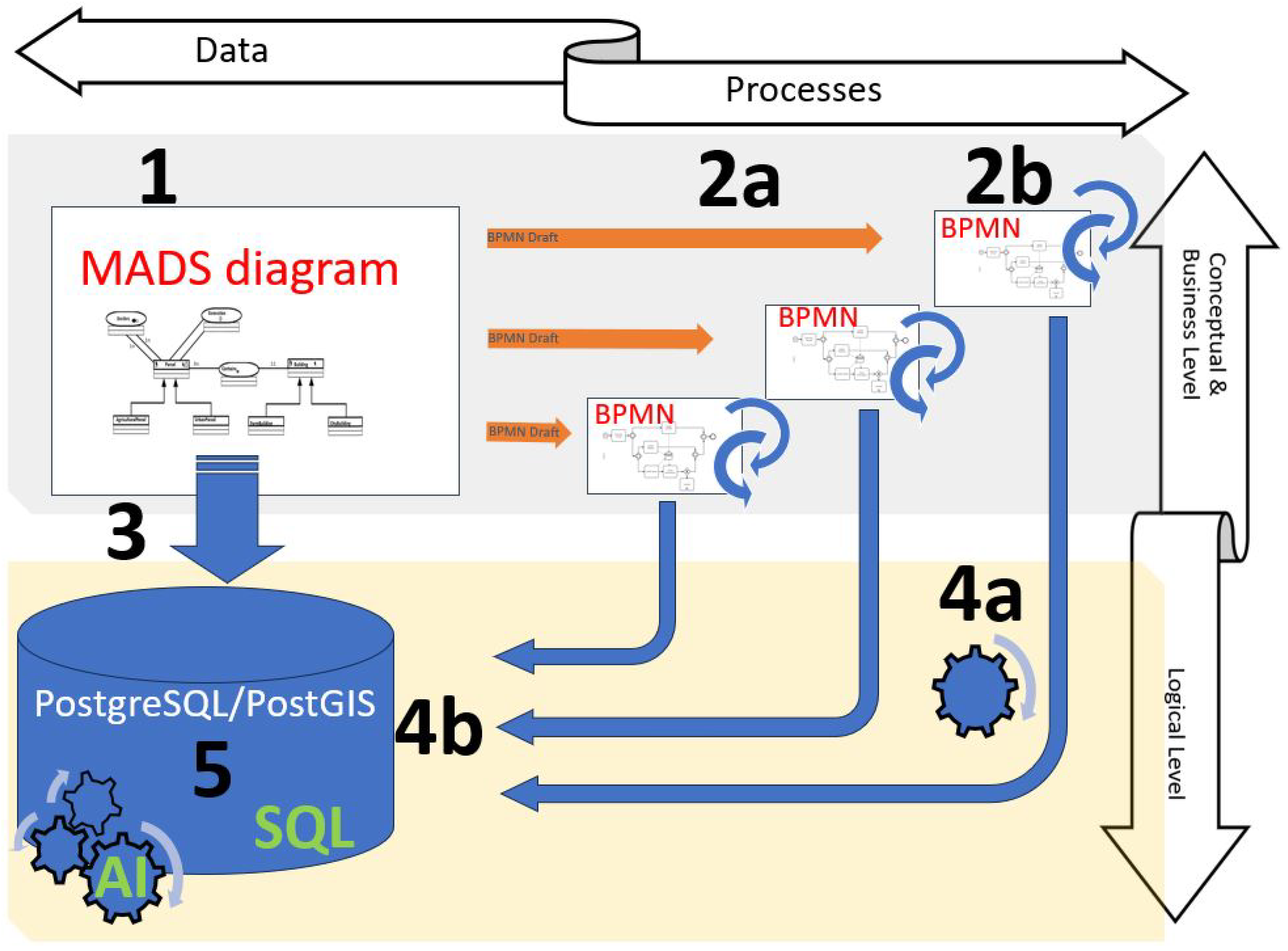
The framework of our approach is visually represented by
Figure 1. In Step 1 of
Figure 1, MADS takes center stage, serving as the foundational structure for primarily representing geographical data. It is a versatile framework that can be applied across a spectrum of studies catering to diverse business needs. This shared conceptual schema ensures uniformity and cohesion across a range of applications and usage scenarios.
Moving on to Step 2, we employ the Business Process Model and Notation (BPMN) to accurately depict business processes. These processes are closely intertwined with the entities modeled by MADS. At this stage, a preliminary BPMN draft (for each specific business case) is automatically generated from MADS (Step 2a in
Figure 1). Subsequently, the designer of each specific business model can enhance this draft, taking into account the constraints and specifications of their particular business model (Step 2b in
Figure 1).
Once the conceptual modeling, which encompasses data modeling and business processing, is complete, our methodology progresses to the implementation of the conceptual model into a logical model (comprising Steps 3, 4a, and 4b). Step 3 in
Figure 1 illustrates the process of implementing MADS diagrams into a relational database. This step offers a structured representation of the spatial and temporal information associated with the case study, making it accessible and manageable. Step 4a involves encoding the BPMN diagram with Object Constraint Language (OCL) logical rules, effectively transforming it into a Petri net. Subsequently, Step 4b demonstrates the transformation of this Petri net into PostgreSQL/PostGIS.
With the comprehensive logical model firmly established, it becomes highly efficient to manipulate it using SQL (Step 5). This empowers users to seamlessly engage with the model and extract insights from the data. Moreover, harnessing data collected from a diverse range of business applications, the methodology unlocks the potential for advanced AI classifiers with the ability to forecast forthcoming scenarios within geographical data, delivering substantial value across a multitude of industries and applications.
To describe the technical implementation, we employ the development of our framework and ensure its applicability to any geographical case study. Further, we will outline the following technical stages, each of which will be dedicated to a subsection:
Coupling MADS With BMPN: automatically generate a draft of the BPMN model based on the MADS model, aligning the business processes with the spatial and temporal dimensions of the case study.
Mapping MADS to Logical Model: Incorporate all entities and associations from the MADS conceptual model, along with their spatiotemporal characteristics, into PostgreSQL/PostGIS.
Mapping BPMN to Logical Model: Encode the BPMN diagram with OCL logical rules as a Petri net, and incorporate Petri net into PostgreSQL/PostGIS.
3.1. Coupling MADS with BMPN
Our approach presents a solution that links geographic data to a business model. For example, spatiotemporal objects like buildings (with their history and topological relationships) are modeled by MADS. The administrative services model the process that automatically tracks the purchase and heritage actions on these buildings (to manage the categorization/classification of these actions and apply financial taxes) by BPMN. Moreover, MADS supports the modeling of additional geographical data such as roads (with their width, their maximum speed, etc.), the location of crossroads and traffic lights, and data associated with some events. BPMN points out a real-time traffic management system process that illustrates how the municipal police manage/organize traffic and adjust the traffic light system during exceptional events (manifestation, national day, etc.).
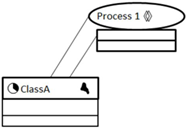
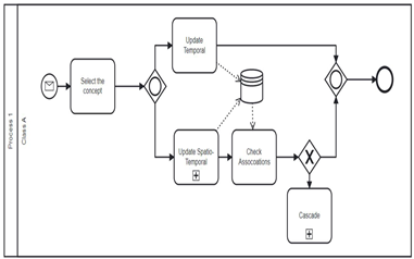
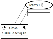
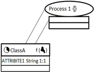
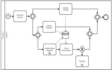
Technically, the approach implies the introduction of a pictogram to MADS to identify STPs. This pictogram is used as a constraint on relationships. Each STP refers to a complete process modeled with BPMN. The pictogram that represents an STP is: . Indeed, with MADS, the STP appears generic, while it is much more detailed with BPMN. After the conception of a MADS schema, a draft BPMN diagram is automatically generated. The MADS STP is transformed into a BPMN “pool”.The class/classes involved in the relation containing the STP and all classes having topological or temporal relations with it/them are transformed into “lanes” of the BPMN pool. Indeed, a process that might modify the spatial or temporal characteristics of a class can also influence its topological and temporal relations with related classes.
Table 1 presents a transformation of MADS STP
into a Lane. A default draft for the BPMN model that takes into consideration all the spatio-temporal features of the original MADS model (subject of the STP) is automatically generated. The designer modifies the draft later regarding the requirements for the business process. In other words, the result of the automatic generation is only a draft; the user can update it or add extra events or lanes when needed. A perspective offered by this work is to create an application with a graphical user interface that will take into consideration the requirements of the users and create an automatic customized draft. The first row in
Table 1 represents the fact that an event inside the general STP can affect the features of the class of objects “ClassA”. ClassA has spatial and temporal attributes that may be modified. A change in the spatial feature of ClassA can modify the topologic relations that link ClassA with other classes (i.e., a check association event can be invoked to select all spatial relations between ClassA and other classes in the MADS model). In the second row, we add an attribute to MADS’s ClassA. In this case, an event can modify the characteristics and/or the attributes of this class. The resulting mapping starts by selecting the type of concept to be updated (i.e., class or attribute). The third row highlights the mapping of the space-varying feature of Class A. This change is considered a spatio-temporal modification of the class concept that results in tracking and storing the old and new spatial values of the object.
3.2. Mapping MADS to Logical Model
This approach combines MADS and BPMN at the conceptual level and PostgreSQL/ PostGIS for implementation. PostgreSQL/PostGIS [
45] is one of the most widely used and powerful spatial open-source SQL-based DBMS [
46]. It is an object-relational database system combined with many features that safely stores and scales data workloads. PostGIS is a powerful open-source software program that adds support for geographic objects to PostgreSQL/PostGIS and follows the SQL specification of the Open Geospatial Consortium (OGC). PostGIS provides the most complete implementation of the OGC Simple Features Specification between free DBMS software [
47].
A series of previous works have provided a series of guidelines for the implementation of MADS into relational DBMS, object-relational DBMS, object DBMS, and XML. Ref. [
22] developed MADS translation rules for relational and object-relational models as well as a translation of queries expressed in MADS algebra into SQL.
The transformation of a MADS conceptual diagram initially consists of defining three groups of transformation rules (i.e., thematic, spatial, and temporal) into MADSLog logical diagrams. The MADSLog logical model is then transformed into Oracle 10 g and GML; GML consists of XML Schema documents and concepts from OGC that define XML-based grammars for encoding geospatial data in XML documents). Ref. [
23] proposed a set of transformations from MADS to db4o, which is an object database.
Our target is to implement MADS in PostgreSQL/PostGIS. The most likely transformation rules are those suggested by Minout [
22] that transform MADS into MADSLog and then to Oracle 10 g. We follow these principles for the transformation of MADS into PostgreSQL/PostGIS.
Our transformation from the entity relational model MADS to PostgreSQL/PostGIS automatically generates the necessary relations, functions, and procedures in PostgreSQL/PostGIS and permits the querying and manipulation of the resulting data. Let us introduce the transformation of the main features of MADS to PostgreSQL/PostGIS.
Table 2 presents some examples of these transformations (The comprehensive transformation of all MADS features and concepts into PostgreSQL/PostGIS is not within the scope of this paper. However, interested readers can refer to [
23] for a detailed explanation of these transformations):
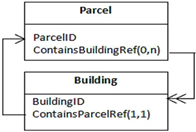
Entities in the conceptual schemas are directly transformed into relations in the logical schema; relationships are translated according to their types (i.e., association, generalization, transformation) into relations or attributes in the logical relations.
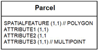
Each attribute has a data type that can be thematic, spatial, or temporal. MADS’s simple thematic data types are directly converted into their correspondences in PostgreSQL/PostGIS. The mapping between MADS and PostgreSQL/PostGIS spatial data types is presented in
Table 3. A MADS multi-valued attribute (i.e., an attribute that takes more than one value) is transformed into an array of attributes in PostgreSQL/PostGIS. An additional PostgreSQL/PostGIS constraint is automatically generated to control the number of values for this attribute.
MADS spatial entity feature is transformed into a spatial attribute named ‘SPATIALFEATURE’. The data type of this attribute will be the spatial PostgreSQL/PostGIS type that corresponds to the spatiality of the MADS entity.
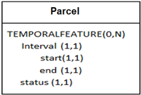
MADS temporal entity feature is transformed into an attribute named ‘TEMPORALFEATURE’ of type ‘lifecycle’. The Lifecycle tracks the scheduling, creation, deactivation, or deletion dates of the MADS class instances.
At a given date, the status of a temporal object can be either planned, active, suspended, or destroyed. The active period of an object is the temporal element associated with its active status in its life cycle [
22]. We implemented the MADS temporal types (Instant, Interval, etc.) with their corresponding temporal functions as object types in PostgreSQL/PostGIS. We benefit from the existing temporal PostgreSQL/PostGIS synchronization functions to simulate MADS temporal relationship constraints. The last line in
Table 2 presents an example of the transformation of the life cycle “interval” of the entity “Parcel” where it is mapped to a multivalued attribute TEMPORALFEATURE composed of the temporal type of interval (with two attributes “start” and “end”) and an attribute status.
In addition to the creation of relations and attributes, all the earlier examples of general transformation presented in
Table 2 generate a set of triggers and functions to conserve the semantics of the conceptual model and maintain integrity constraints. For example, a procedure to check the non-violation of constraints of the cardinalities between entities and relations is automatically generated. Moreover, when a topological relationship relates two entities, a function that checks the validity of the references is also automatically generated. These functions are triggered after each insert and update of any object in each entity.
3.3. Mapping BPMN to Logical Model
After the transformation of the MADS conceptual schema into a set of tables and constraints in PostgreSQL/PostGIS, we aim to transform the updated MADS’s related BPMN into an executable model that materializes process modeling into queries supported by PostgreSQL/PostGIS. This updated BPMN model we aim to transform represents the evolution from the initial BPMN draft, which was automatically generated from MADS and refined to align with the unique requirements of each business model. According to [
29] a conforming BPMN implementation must support the usage of all constructs defined in the standard, implement the behavior of the constructs as specified, be able to detect invalid BPMN process models and consume the standardized serialization format. In terms of process executability, some attempts have been made to implement BPMN. The Business Process Execution Language (BPEL) is an XML-based language used for business process implementation. While BPMN provides a graphical representation of a given process-based model, BPEL is used to exchange (i.e., export–import) and execute data; BPEL enables the specification of BPMN. Although the mapping between BPMN and BPEL is complex, flawed, and has various problems. The work of [
48] makes use of XML nets, an executable method for Petri net process modeling. The model represents the data needed by the process using a graphical language, and the data manipulations are graphically displayed in the XML nets. Refs. [
49,
50] proposed a transformation and visualization of BPMN models into Petri Nets.
The formal language Petri nets have found extensive applications in industrial systems and are considered a suitable language to do such analyses due to the availability of many existing analysis tools. Ref. [
50] proposed a mapping from the conceptual model BPMN to the executable one, Petri Nets. Ref. [
51] describes a formally well-founded approach to linking data and processes conceptually, based on adopting UML class diagrams to represent data and BPMN to represent the process using OCL operation contracts. In [
51], OCL is used mainly to define a textual integrity constraint that UML instances of the schema should satisfy and the operation contracts that UML instances should satisfy before/after executing some operation recorded in BPMN. Ref. [
8] used OCL to describe BPMN constraints.
Our approach for implementing MADS and executing BPMN in PostgreSQL/PostGIS aligns with the methodology employed in [
51]. Indeed, even though BPMN can be directly executable thanks to BPMN engines like Activity (
http://www.activiti.org/), jBPM (
http://www.jbpm.org/), and Camunda (
http://www.camunda.org/) URLs accessed 1 September 2023, we used Petri net in our implementation. Petri net is used to check the correctness of BPMN and to have complete control of the transformation of the BPMN concept with OCL annotation into SQL queries for PostgreSQL/PostGIS. Furthermore, Petri net presents a clear, mathematically proven, and easily understandable visual workflow model.
We used OCL expressions to enhance the semantics of BPMN and strongly link its elements/activities with the MADS objects and, as a consequence, with the relations representing MADS objects in PostgreSQL. An OCL expression written for BPMN and referring to a MADS object gives us the ability to navigate to relations related to this object through some actions using the name of the subprocess (event) we want to traverse. The resulting BPMN model is executed thanks to the Petri net. To map BPMN tasks, events, and gateways into Petri-net modules, our approach was firmly rooted in the principles outlined in [
6]. We diligently adopted and fully used these principles throughout the entirety of our transformation process. For an in-depth exploration of the mapping between BPMN and Petri-net, we encourage interested readers to consult reference [
6].
Figure 1 represents an example of mapping from BPMN to Petri net following [
6].
Since the query that each action of the process needs to select, insert, update, delete, or return may be described by a relational algebra notation and, consequently, a SQL statement, the executability of the overall framework can rely on relational SQL technology in this way. Specifically, the OCL contracts are encoded as logic rules that determine which SQL statements must be applied to the database when an activity is executed, the BPMN diagram is encoded as a Petri net, and the MADS logical diagram is encoded as a relational database.
The following institutional and real-world context case study illustrates our approach to modeling data (land spaces) and process (land management) using MADS and BPMN. Data for a “city” are first modeled in MADS and automatically transformed into PostgreSQL/PostGIS, then a BPMN draft reflecting the constraints of the MADS data model is automatically generated. The draft of BMPN is then manually updated concerning the specific business requirements of land reform and management. The BPMN model is then manually annotated by OCL and automatically transformed into a Petri net to assure its executability in PostgreSQL/PostGIS.
4. Merging Spatio-Temporal Conceptual Model and Business Process: Land Reform Process Case Study
For the case study, we developed a syntactic model inspired by the demolition process of a commune in Nantes, France, specifically the “Malakoff” district. This syntactic model enables us to accurately represent and analyze the demolition process of buildings and parcel reallocation and reform. For instance, information for a parcel encompasses a comprehensive set of data, providing insight into its physical location, owner information, area, dimensions, land use type (urban or agricultural), boundaries with neighboring parcels, position within the city, and the presence of any structures with their respective attributes, if applicable. Moreover, the parcel’s data include a temporal attribute indicating the span of its administrative existence. The spatial characteristic of each parcel is inherently time-dependent, implying that the parcel’s geometry can evolve over time, reflecting changes in its boundaries or physical layout.
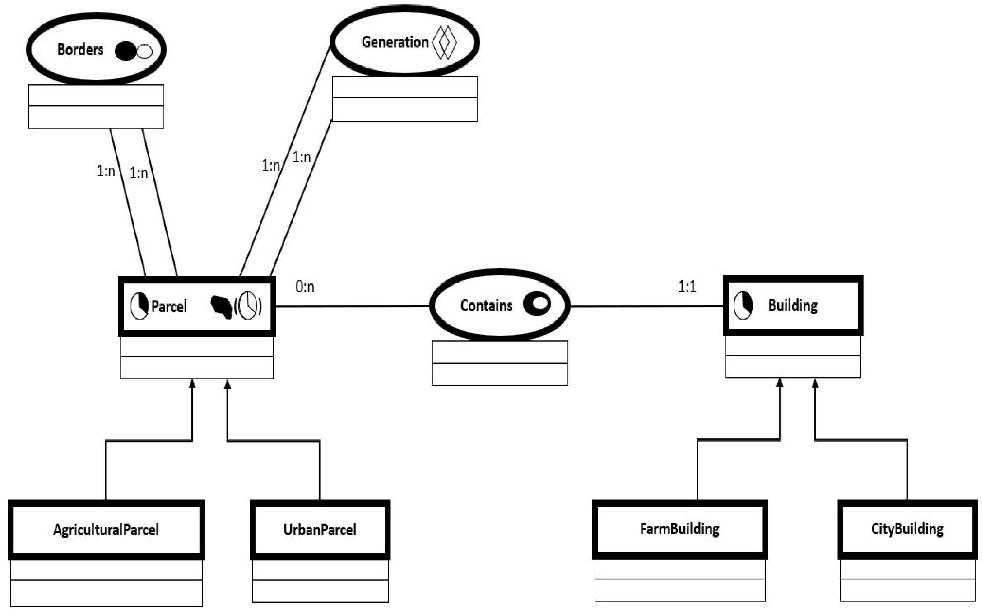
The following MADS conceptual model in
Figure 2 represents our case study. It considers six classes of objects and three relationships (i.e., two associations and one STP). The class “Parcel” has temporal and spatially varying features. The two main categories of Parcel are “Urban Territories” and” Agricultural Parcel”. The borders between parcels are registered within the association borders as having “touch” as a topological relationship. Parcels may contain zero to many “Buildings” that can be either “Farm Buildings” or “City Buildings”.
Figure 3 shows a soft logical schema resulting from the transformation from MADS to PostgreSQL/PostGIS by applying the transformation rules discussed in the section “MADS Implementation”. “Generation” is a specific type of relationship representing a spatio-temporal process (STP). This STP is the main modeling abstraction of the BPMN presented in
Figure 4.
On the other hand, “urban planners” or “city planners” are responsible for managing the growth and development of a city over time, encompassing considerations such as anticipated growth areas, changes in agriculture, urban development, and the preservation of green zones. Urban planning involves a diverse range of activities to create well-functioning cities and make informed decisions related to land use to foster the growth and development of cities. Our BPMN provides an illustrative example used by urban planners to model and track the land reform process, which includes actions such as parcel division, boundary alterations, category modifications, construction, and more. This syntactic model represents and analyzes the demolition process of buildings and parcel reallocation and reform. BPMN models the fact that many lands may be joined together to form one land or a land can be reformed or split into many smaller lands, or an agricultural land becomes an urban land, and vice versa. The spatial dimension of a parcel can also be rectified and modified. BPMN further denotes “why” and “by the response to which event” a specific modification of a parcel occurs. The mapping of an STP is developed into BPMN as a pool as follows: Parcel, Border, Contains, and Buildings are automatically transformed into lanes, where all have topological relations with Parcel. Submit a reform request in the parcel, which can be: limit change, aggregation (e.g., when the owner of a parcel buys another one and merges it with the first one), split (e.g., when the owner of a parcel buys apart from it), re-allocation, or modification of category (e.g., urban becomes agriculture). These sets of events cannot be generated automatically because they are specific to the process of land reform and are not known in advance. Indeed, the designer should update the auto-generated draft to meet these requirements.
OCL is used to annotate BPMN and link it with the PostgreSQL/PostGIS relational model representing MADS. The following contains a soft example of the OCL contracts for the events and activities of the BPMN. The link between the Lanes Parcel and Borders is interpreted as follows:
If the event “split” for example (characterized by the purchase of a part of parcel1 and the creation of a new parcel2), occurs and updates the spatial and temporal features of an existent object (e.g., parcel1), this leads to an update and tracking of the MADS’s spatial value “polygon” of this parcel (and by consequence, in a second part, updates the temporal and spatial features of the created parcel: parcel2). Thanks to OCL, these steps can be introduced to increase the semantics and assure the executability of the BPMN events “Update Spatial”, and “Update Temporal” for “parcel 1”. The head of each rule in OCL (update) determines the SQL statement that will be applied.
OCL:
Update parcel1:
context Parcel::updatetemporal(temp :int[])
post: self.TEMPORALFEATURE=temp
context Parcel::updatespatial(spl :polygon)
post: self.SPATIALFEATURE=spl
The “update spatial” event will lead to checking (among others) the associations between the lane Parcel and itself (and with the lane Building) and “Select relevant” parcels (and buildings).
OCL:
Select relevant:
In the “Border” lane, the “Select Relevant” event leads to the “Manipulate Topological Relation” event that updates the values of MADS parcel1’s relations with adjacent parcels and “Submits Reform Request” event for other object parcels where their spatial/thematic values are affected/created by the spatial modification on parcel1. Indeed, “Select Relevant” in the lane “Border” takes us back to the Lane Parcel and a similar process will be applied to parcel 2.
To connect the process events to the data, we connect every activity, decision, and message received or sent in the BPMN to the relational model resulting from the implementation of MADS schema. By using formal language to express the prior activities and start/end/message events and applying the Petri Net semantics for BPMN control flow, this description of the state evolution of all MADS objects becomes fully executable. Therefore, each activity in the BPMN diagram is specified for this purpose using an OCL operation contract. Each OCL action contains a precondition that specifies the requirements that must be met before the job can be completed, as well as a postcondition that describes the system’s state following the operation’s execution.
The BPMN diagram is formalized into a Petri net. We focus on formalizing BPMN models’ control flow, which specifies how tasks and events should be executed. Petri nets have an initial marking that symbolizes the BPMN model’s beginning condition. Each task will roughly correspond to a transition with one input and one output location. To represent the routing behavior of the gateway, gateway nodes will typically correspond to a combination of places and silent transitions.
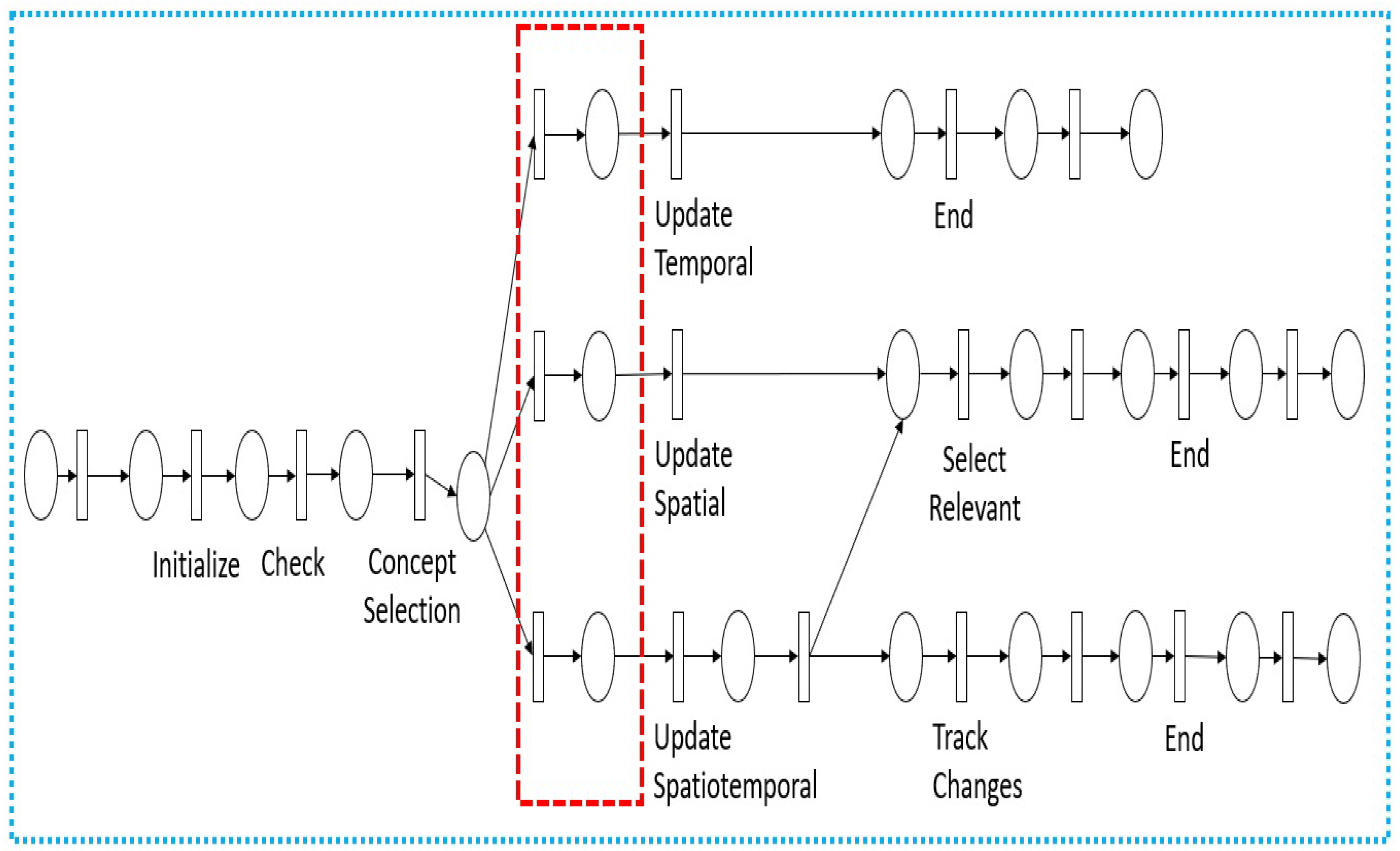
The Petri net we obtained in our case study is shown in
Figure 5. Each task corresponds to a labeled transition, which has one input and one output place. Each gateway node maps to a set of places and transitions. The dotted rectangle in
Figure 5 shows the transitions and places corresponding to the translation of the XOR merge gateway placed after the task “Submit reform request”.
Each OCL operation contract is written and used in Petri net as a set of logic rules from which we can infer the insertions, deletions, and updates that must be made to the PostgreSQL/PostGIS database to carry out the operations. By doing this, we transition from the declarative OCL specifications to an executable imperative formalism. Each logic derivation rule’s head specifies the type of SQL statement to use (insertion, for example), and its body details which values to use. That is, logically, a rule of the first form states that if the precondition is satisfied, then some facts (insert, delete, update) must be inserted in the database when a business event occurs (select relevant, for example).
5. Discussion
The combination applied between MADS and BPMN gives the user full control of the conceptual model and the ability to clearly define when and how a process will impact the objects represented. The modeling of the process provides qualitative information that describes spatio-temporal changes and fulfills the need for an accurate representation of a real-world evolution. The representation of processes is distributed at the most appropriate level between MADS and BPMN: in MADS, the generic form is kept, while with BPMN, the specificity of each process is represented for management purposes.
Consequently, our modeling approach offers the following contributions:
Holistic framework for MADS and BPMN Integration: it introduced a novel holistic framework that leverages the synergies between MADS and BPMN. While conceptual modeling approaches, like MADS, are invaluable for clearly modeling complex geographical areas of study, they may fall short in depicting the intricacies of data management processes within an organization, especially when data management tasks predominate.
Shared conceptual model for geographical data: it established an understandable shared conceptual model for geographical data and seamlessly made it compatible with various business models. An initial draft of the business model is automatically generated. Our approach preserves the separation of data, business processes, and applications. This separation is a novel contribution to the domain of geographical data and is crucial for maintaining flexibility and adaptability as requirements evolve. It facilitates data reuse, promotes extensibility, and establishes a clear distinction between data and process modeling.
Integrated view: it provides a technical integration of conceptual and business modeling abstractions into a logical model. It provides a comprehensive view of geographical data within an organization, including its associated data management tasks.
Adhering to standard SQL: The logical implementation of the conceptual and business models into PostgreSQL, adhering to standard SQL practices, ensures the wide applicability of our proposed framework. This ensures compatibility with static data that already exists within large organizations.
Furthermore, our approach paves the way for additional advantages that we plan to elaborate on in the future perspectives of this work. The following are potential supplementary contributions we intend to develop:
Streamlined data manipulation: Geographical objects exhibit continuous evolution in both spatial and temporal dimensions. Any alteration made to a geographical object may necessitate complex updates to neighboring spatial objects. Our framework can be used to simplify this work by modeling all potential modifications as an integral part of the business process, leveraging BPMN, and automating the execution through Petri Net. Initiating each process and defining specific constraints using the OCL language is all that is required, allowing Petri Net to dictate the execution of tasks and events seamlessly.
Deep analysis of modifications: While traditional approaches focus on answering “what, when, and where” questions about geographical data as reflected by conceptual models, our methodology goes deeper, elucidating “how and why” modifications occur (what the trigger was, the event, and the consequences), enriching the context for analyzing and decision-making, generally part of business modeling approaches. Additionally, by embracing our approach, we aim to unlock the potential for more advanced AI classifiers, enabling them to forecast forthcoming situations in geographical data and be able to answer “foresight” questions. This capability holds vast value across various industries and applications. For instance, these new types of queries are supported:
What are the consequences of splitting parcel A? As the business process of splitting parcels is well defined and tracked thanks to BPMN, the consequence of any event is logged and can be queried.
What are the consequences of changing the category of parcel A (from agricultural to urban) to building X? Following the BPMN process model, any event has an input and a defined output.
What are the consequences of the application of a new law concerning the rules for the classification of land and buildings in a city? All BPMN events transformed in Petri net, that are involved and executed will be logged with their corresponding consequences in the PostgreSQL/PostGIS tables.
Why is the topological relation between building A and parcel B modified? The log file for “Manipulate topological relations” is the consequence of “update spatial” related to one of the land reform BPMN events (split, merge, etc.).
Why is the spatiality of parcel A modified (in a specific period)? The log file for “update spatial” is the consequence of one of the land reform BPMN events (split, merge, etc.).
Indeed, this paper bridges the gap between conceptual modeling and data management processes. It extends beyond geographical data organization and exposes the analysis of the characteristics of specific spatiotemporal objects that may undergo multiple events over time. These contributions collectively aim to streamline and enhance the utilization of geographical data within organizations, promoting efficiency, adaptability, and a unified understanding.
6. Conclusions
We proposed in this article a robust integration of MADS and BPMN as popular formalizations for spatiotemporal data conceptualization and business process management. Closer coupling of MADS with BPMN empowers designers to specify and manipulate spatiotemporal data at different levels. Our approach initially introduces the conceptual integration of MADS and BPMN, followed by mapping the entire model into a PostgreSQL/PostGIS database. This framework automates the link between data and business processes using OCL and Petri nets. OCL aligns business activities with relational model relations, while Petri nets ensure precise execution order following BPMN. We presented a syntactic case study, primarily designed as a proof of concept. It focused on studying the business process involved in tracking land reform for the specific commune of ‘Malakoff’, situated within the larger city of Nantes, France. It entailed actions such as parcel division, category modifications, and more. This case study offers a concise yet informative demonstration of the technical feasibility of the integration we have developed between MADS and BPMN.
In summary, our modeling approach combines MADS and BPMN and presents numerous benefits:
Empowering designers to convey data modeling concepts effectively through MADS.
Providing a shared conceptual framework that aids stakeholders in understanding and utilizing the data model for specific processes.
Enabling business model designers to build upon the primary MADS model for process development, ensuring consistency, and establishing a semi-automatic link between MADS and BPMN.
Establishing a common reference point through MADS facilitates interconnectivity among events from various business processes related to the same spatial object, paving the way for AI-driven predictions.
Maintaining compatibility with SQL for querying geographical data through automatic transformations and specialized languages.
Consequentially, our approach holds great promise in the realm of urban data and city management. For instance, a municipality can employ a shared MADS model to encapsulate the spatiotemporal characteristics of a district. Subsequently, various departments, such as those focused on road safety and innovation, can build their unique business models using this shared foundational structure. This approach proves particularly valuable in activities like analyzing building sales, aiding in the comprehension of location preferences, and avoiding pitfalls. Historical data can be recorded and explained through pre-defined business models, rendering it easily accessible for requests and thorough analysis.
Conversely, we have recognized the following limitations in our approach:
Dependency on well-defined conceptual models: This approach is most valuable in structured scenarios, such as cadastral or land management, where geographical objects and processes are well-defined. It may be less effective in less structured environments, like volunteer GIS or crowd-sourced databases.
Interface development is required for full implementation, including a user-oriented graphical interface to facilitate the design and management of BPMN drafts auto-generated from MADS and ensure widespread adoption and utilization of our approach.
Future directions involve expanding our efforts beyond the limited scope of testing our model with synthetic data. Our primary focus will be on real-case applications to thoroughly evaluate its performance and scalability. Additionally, we will prioritize the development of a user-oriented graphical interface and the incorporation of OCL for event annotations to enhance clarity. This integrated modeling approach unlocks possibilities for advanced analysis, AI analytics, classifiers, and data mining. It enables the discovery of associations and correlations within log files generated by BPMN models. These enhancements provide fresh insights and data-driven decision-making for urban and environmental applications within geographical contexts.
