Abstract
Forest fires can have devastating effects on the environment, communities, individuals, economy, and climate change in many countries. During a forest fire crisis, massive amounts of data, such as weather patterns and soil conditions, become available. Efficient management, intelligent integration, and processing the available information in order to extract useful insights and knowledge to facilitate advanced whereas and support human operators and authorities in a real operational scenario is a challenge. In this work, we present ONTO-SAFE, an ontology-based framework for wildfire events, adopting Semantic Web technologies for data integration and infusion of domain and background knowledge. More specifically, the framework creates a unified representation of the available assets, taking into account data generated from different sources, such as sensors, weather forecasts, earth observations, etc. To this end, previously existing ontologies and standards are used, such as Empathi and EmergencyFire ontology, to provide the conceptual model and the necessary level of abstraction in the form of interconnected knowledge graphs to satisfy the modeling requirements. On top of the generated knowledge graphs, a declarative framework extracts facts and higher-level inferred knowledge from asserted data to support users in decision making. In addition, the framework supports the generation of recommendations, such as sharing important wildfire information with citizens and professionals, that can be adjusted based on user-defined factors and the current disaster risk management phase.
1. Introduction
Climate change has a significant role in extreme weather events such as heat waves, large storms, and forest fires, and it is becoming increasingly important for the scientific community and decision makers [1]. As global temperatures continue to rise, the frequency and severity of wildfires are increasing. Managing the impacts of wildfires requires careful decision making and a combination of measures, including reducing fuel loads, and managing forested areas [2]. This can involve early warning systems, coordinating firefighting efforts, and supporting affected communities in their recovery [3]. Early communication, such as prediction of the rate of fire spread, fire line intensity, the potential impacts, and protection actions and procedures, is very crucial and assists professionals and citizens in protecting their lives and property [4]. In emergency situations, it is critical to be able to precisely analyze information in order to give relevant, dependable, and accurate information to a user when and where it is needed [5]. For this reason, disaster management systems (DMS) and disaster support systems (DSS) aim to overpass human weaknesses (e.g., fatigue, errors, limited cognition, etc.) with the use of the Semantic Web to assist in the development of a plan or reaction to a certain situation.
Semantic Web technologies are employed to facilitate knowledge management from data sources, provide rich knowledge graphs (KGs), and assist stakeholders in forest fire decision making by utilizing contextual information and new levels of information [6]. With their ability to integrate heterogeneous data from various sources [7], these technologies have a significant amount of potential for extending the information available on the web by providing an understandable meaning that can be used by applications to assist emergency management [5]. The Semantic Web provides numerous benefits to DSSs [8] because it is efficiently integrated with decision support approaches including the methods of analytical hierarchy and sensitivity evaluation for enhancing the function and oversight of complicated natural phenomena such as wildfires.
In order to effectively manage the issues caused by wildfires, this work aims to formalize the complex knowledge that is produced during wildfire events in order to provide a common, shared vocabulary and develop a decision support system (DSS) that can assist decision makers in making informed decisions. To do so, we discuss the ontology-based decision support framework that aims to enhance information sharing among stakeholders and facilitate advanced whereas in forest fire emergencies. The presented framework performs as a supporting mechanism in the decision-making process during a wildfire event. An overview of the initial architecture of ONTO-SAFE’s framework and the ontology conceptualization was presented in reference [9]. This paper represents a significant extension of the previous approach. First of all, the initial ontology was updated to also capture information regarding weather and forecast anomalies, weather conditions for prescribed burning, as well as the decision support aspects. Furthermore, the reasoning module for decision support was expanded with additional semantic queries and rules to provide relative content that takes into account the aforementioned ontology enhancements. The main additions of this paper are (a) the final version of the ONTO-SAFE ontology that is able to semantically represent the weather anomalies of fire weather index (FWI), drought, duff moisture, fine fuel moisture, the weather conditions of the prescribed burning process, and the generated alerts and recommendations, and (b) an extended ontology-based decision support module which offers pertinent recommendations taking weather conditions and forecast-related variables into account.
The main contributions of this work can be summarized in the following:
- We present an updated version of the ONTO-SAFE ontology that offers enhanced semantic capabilities, enabling it to effectively capture various situations associated with forest fires.
- We introduce the functionalities of the ONTO-SAFE framework, which includes the ability to identify anomalies in factors including drought, moisture, and FWI, and the appropriate conditions to conduct the prescribed burning process, promoting effective fire management strategies.
- We propose an improved semantic reasoning mechanism within the ONTO-SAFE framework, leading to real-time alerts and valuable recommendations with efficient response time, effectively assisting decision makers during forest fire emergencies.
- We demonstrate practical use cases focusing on weather and forecast anomalies, along with the prescribed burning process. These use cases showcase how our framework actively assists decision makers in forest fire emergency situations, empowering them with valuable insights and support.
The rest of the paper is structured as follows. Section 2 describes the background and related work regarding semantic web technologies, ontologies, decision support systems, and their contribution to emergency management and disaster planning. An overview of the architectural design of the ONTO-SAFE framework is presented in Section 3. Section 4 illustrates the ONTO-SAFE ontology with the relative additions and the semantic representation of fundamental concepts. Semantic reasoning for decision support is demonstrated through simulation examples in Section 5. In Section 6, the evaluation results are presented, and Section 7 discusses the results obtained from the simulation examples. Finally, Section 8 follows with the conclusions of the paper.
2. Background and Related Work
The Semantic Web is defined as a web of data that machines can process both directly and indirectly [10]. It is an extension of the existing World Wide Web (WWW), and the information included inside it is described in a formal, machine-understandable manner. The term was coined by Tim Berners-Lee, the inventor of WWW and director of the World Wide Web Consortium (W3C), which supervises the development of the proposed Semantic Web standards. In order to create a common framework that enables data to be shared and reused across applications, companies, and community boundaries, the Semantic Web works to give meaning and value to the data [11]. As a result, the Semantic Web is considered to be an integrator of various materials, information, applications, and systems.
Semantic Web technologies with for emergency management-related ontologies and decision support systems have been studied in various domains. The related ontologies and the semantic web technologies that act as the basis for the ONTO-SAFE ontology and semantic reasoning module are covered in detail in the following subsections, along with a general overview of the existing research in this field.
2.1. Semantic Web Technologies
Ontologies play a key role in the Semantic Web, because they provide a technique for dealing with various and heterogeneous web resources and give machine-interpretable semantic vocabulary [12]. They were developed to facilitate knowledge sharing and reuse as they can be widely used to model domain information effectively due to their ability to represent and organize information, context, and relationships more accurately. Thus, ontologies are becoming increasingly popular as a result of their ability to provide a shared and common understanding of a domain between humans and application systems [13]. As such, the use of ontologies and supporting tools offers an opportunity to significantly improve knowledge management capabilities in many different fields.
The Resource Description Framework (RDF) is a general knowledge representation for the web that aims to enable the encoding, exchange, and reuse of structured metadata [14]. RDF provides a model for representing knowledge as a set of triples, which consist of subject–property–object statements [15]. Each triple represents a relationship between two resources, with the subject and object being resources (identified by URIs) and the property representing the relationship between them. A set of RDF statements is known as an RDF graph, which enables data integration, linking, and reasoning across different domains and applications [16]. RDF is complemented by other technologies and standards such as OWL (Web Ontology Language) for defining ontologies and the SPARQL query language for querying RDF data.
OWL is a knowledge representation language commonly used to create ontologies in the Semantic Web community [17]. The syntax of OWL is the syntax of RDF, and the semantics of OWL are an extension of the semantics of RDF, according to the definition of OWL as an extension to RDF in the form of a vocabulary entailment [18]. Especially, OWL is a Semantic Web language for representing rich and complex information about things, groups of things, and the relationships between them. OWL contains three more expressive sublanguages developed for use by specific communities of users: OWL Lite, OWL DL, and OWL Full [19]. These sublanguages provide different levels of expressiveness and reasoning capabilities, allowing users to select the appropriate level of complexity based on their requirements. OWL DL is a notational variant of description logic (DL) [20], as OWL Lite uses a subset of the OWL language features and has more limitations on using the features than OWL DL or OWL Full. The most expressive OWL sublanguage is OWL Full. It is intended for usage in cases where a high level of expressiveness is more important than the language’s decidability or computational completeness [19]. OWL ontologies can describe a wide range of knowledge, from simple taxonomies to complex domains with complicated relationships. They can be utilized in a variety of applications, including data integration, information retrieval, semantic search, intelligent agents, and more. To retrieve information based on the defined knowledge, OWL ontologies can also be queried using the SPARQL query language.
SPARQL [21] is a declarative language proposed by the W3C for obtaining and updating information from RDF graphs. It is an expressive language that allows one to explain complex relationships between individuals. The semantics and complexity of the SPARQL query language have been thoroughly examined theoretically, revealing that SPARQL algebra is as expressive as relational algebra. SPARQL is best known as an RDF query language. Still, it can also be used to build SPARQL rules that can combine smaller RDF graphs into bigger ones to create new RDF data. The result is an RDF graph created by taking each query solution in the solution sequence, replacing the variables in the graph template and developing a combination to merge the triples into just one RDF graph.
Together, all the above-mentioned technologies create a basis for building intelligent applications that can leverage the power of the Semantic Web.
2.2. Ontologies and Ontology-Based Systems for Emergencies
Ontology-based emergency management systems are frequently utilized to assist decision makers and first responders manage disasters in a more effective way. Thus, an effective emergency management system provides a solution to the problem of the generated heterogeneous data and is widely used in various domains. Numerous research investigations have been conducted as a result, and they are discussed in this section.
First of all, SoKNOS [22] is an ontology-based emergency management system that aims to support users with the ability to enhance their accessibility of the appropriate information at the appropriate moment. The system incorporates a range of data sources, including real-time sensor data and conventional emergency management data sources to provide a comprehensive view of the emergency situation. One of the key benefits of the SoKNOS system is the ability to define relationships and patterns between resources and damages and identify anomalies in the data. The system can effectively detect crucial information and inform responders of potential hazards by using ontology to express the underlying knowledge and connections between concepts. Numerous use cases evaluated the SoKNOS system and illustrated how the use of ontologies and semantic technologies may increase the functionality and adaptability of emergency management systems. The evaluation of the SoKNOS ontologies was conducted with the assistance of end users via relative workshops to consolidate and validate the engineered ontologies.
Another highly relevant approach is Empathi ontology [23]. This ontology conceptualizes the core concepts that define the field of the management of emergencies and hazard crisis mitigation. Empathi ontology was utilized for disaster concept recognition in a social media conversation to assist in crisis management and hazard situational awareness during emergencies. The Empathi ontology was created with Semantic Web language (OWL) and incorporates connections with other significant ontologies including Friend of a Friend (FOAF) ontology [24], SIOC [25], DCMI metadata terms vocabulary [26], and LODE [27]. Age group, event, hazard type, hazard phase, impact, status, and other fundamental concepts are included in the 423 classes and 338 relations that constitute the Empathi ontology and some of them such as fire, impact, location, report, etc., are effectively reused in the construction of ONTO-SAFE ontology as described in Section 4. For the quality evaluation of Empathi ontology, three dominant criteria were used: structural, lexical, and semantic relational evaluation using a human judge. The main objective of Empathi ontology is to map the words of social media content to ontology classes and increase the understanding of the concept of this text in order to enhance knowledge in the emergency management situation. In this way, users are able to categorize communications as relevant or irrelevant to a emergency and extract pertinent information from unstructured social media content.
In addition, EmergencyFire ontology [28] is an ontology that describes emergency response protocols for fire emergencies in buildings. The main objective of the EmergencyFire ontology is to enhance information integration and supports knowledge sharing in order to assist organizations to quickly respond in a building fire crisis. This ontology contains 103 classes, 67 subclasses, 34 object properties, 26 datatype properties, 34 instances, and 21 swrl rules, and the ontology’s evaluation process was conducted by experts who evaluated the classes, properties, taxonomy, rules, and instances of the ontology. Some potential classes were found in EmergencyFire ontology such as fire, incident, weather conditions, and communication, which cover needs that also exist for the design of the ONTO-SAFE ontology as represented in Section 4. The applicability of the EmergencyFire ontology facilitates sharing of information and helps the emergency system to automatically reason through inferences. When a user reports an emergency, the program responds with the protocol to be followed along with the actions to be taken and the involved organizations and resources. In this approach, the EmergencyFire ontology’s interoperability reduces the probability of false compliance while improving response times in emergency situations.
Moreover, the BACAREX ontology [29] is a component of the SIADEX framework, which facilitates the development of strategies for combating forest fires in the Andalusian regional government. BACAREX is a heavy-weight ontology of objects and contains resources (people, squads, vehicles, facilities, etc.), activities (transport, water spraying, refueling, etc.) and additional data (GIS information, weather forecasting, etc.) related to the forest fighting plan. The ontology provides the information needed for the planning process. It keeps track of both organizational (e.g., the location of the object) and informative data for each object it maintains, such as the responder’s radio channel for a specific forest area that may be required by the decision makers during a forest fire incident. This ontology contains more than 130 classes and more than 2000 instances only for planning objects and without taking into account the representation of activities.
Furthermore, geo-ontology [30] is presented as an ontology representation of the meteorological disaster system. By extending the ontology to encompass a spatial and temporal context, geo-ontology enables the definition of concepts pertaining to the geospatial environment. These relationships can then be incorporated into reasoning statements during decision-making processes. Through the utilization of a multi-level ontology model, semantic support is provided throughout the entire emergency management cycle, covering activities such as risk assessment, resource preparedness, and emergency response for the periods before, during, and after the event. As a result, geo-ontology is suggested as a solution for addressing the challenges posed by the meteorological disaster system because of its geographic characteristics. The primary objective of this ontology is to meet the informational requirements of the planning and response stages of meteorological disasters.
Semantic integration is applied in another highly relevant approach. Kalabokidis et al. [31] present a geo-portal system in the area of wildfires using OntoFire ontology. This ontology comprises numerous concepts such as topography, vegetation, weather, climate, and fire in order to represent the semantic context of wildfires and their associated dangers. The relationships between the data can be uncovered by the suggested navigation mechanisms, which is otherwise not achievable when utilizing traditional querying approaches alone. Via the use of a browser, the user engages with the system by navigating to relevant geo-informational resources and learning about the semantic relationships therein. Graduate students with a wide background in geoinformatics and environmental risk management and users from local fire authorities evaluated the ontology and the system’s capabilities using related scenarios and provided their feedback on the system’s functionality.
In the area of crisis management, BeAWARE ontology [32] represents crisis management techniques for climate-related emergencies such as floods, earthquakes, forest fires, etc. The ontology is a component of the decision support system developed in the context of the beAWARE EU-funded project [33]. BeAWARE ontology reuses and combines features from existing ontologies, such as MOAC [34] and SoKNOS [22], and merges all pertinent aspects of crisis management. This ontology incorporates heterogeneous data from crisis incidents and related impacts, sensor analysis, social media, and first responder unit allocations. BeAWARE ontology contains 38 classes, 21 subclasses, 37 object properties, and 22 datatype properties, which indicates that the suggested ontology is a lightweight ontology that can be readily adapted by different applications. Several classes, including incident, impact, location, dataset, mission, etc., are efficiently reused in the ONTO-SAFE ontology. The evaluation of this ontology was conducted via OOPS! (Ontology Pitfall Scanner), an online tool for identifying the most common pitfalls in ontologies [35], in order to assess the consistency and overall quality of the ontology. Furthermore, competency questions (CQs) were translated into SPARQL queries to evaluate whether the retrieved results satisfy the requirements of the end users.
3. ONTO-SAFE Architecture
A high-level description of the ONTO-SAFE framework’s architectural design is presented in this section. More specifically, Figure 1 represents:
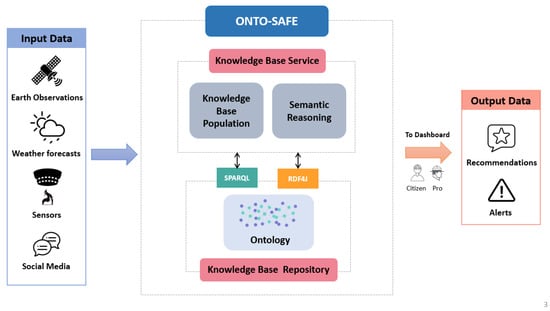
Figure 1.
ONTO-SAFE architecture.
- Input data are the data that the ONTO-SAFE framework is responsible for translating into RDF-based triples (subject, property, object). In particular, the ONTO-SAFE framework attempts to create a unified representation of the assets that are available by incorporating data from a number of sources, including weather forecasts, fire sensors in forests, earth observations from Copernicus and GEOSS, and social media and other applications that residents and emergency stakeholders can use to share information regarding the situation in the field. More specifically, the data obtained from weather forecasts encompass various weather-related factors specific to a particular location, including temperature, humidity, wind speed, and precipitation. The integration of these data assist in accurately assessing and anticipating weather conditions that could potentially contribute to forest fire emergencies. On the other hand, data sourced from the Copernicus system provide valuable insights into the landscape. This includes information about land cover, which aids in understanding the terrain and potential fire risk areas. Additionally, the Fire Weather Index (FWI) data derived from this system plays a crucial role in evaluating the level of fire danger across Europe, enhancing our ability to respond proactively to forest fire incidents. Moreover, data received from social media applications include information regarding the forest fire such as timestamp, location, media items, etc. These real-time data contribute to a more comprehensive understanding of ongoing forest fire situations. Furthermore, data obtained from fire sensors play an essential role in providing immediate and accurate information about forest fires. These data include timestamps, precise locations, and the direction of the fire, enabling quick and effective response strategies. The generated data are delivered in NetCDF, JSON, or GeoJSON format and analyzed by the ONTO-SAFE framework.
- ONTO-SAFE framework is the central component that is responsible for the successful collection of the generated data from the various sources (i.e., earth observations, weather forecasts, sensors, social media, etc.) and analyzes and converts the input data into valuable information to produce the relative output data. The following components constitute the ONTO-SAFE framework:
- -
- Knowledge base repository (KBR), which supports the storage of the ontology and the results of a semantic process. KBR provides native RDF triple storage by providing a way to store RDF triples in a model similar to the graph model, and services to run complex queries on it in an acceptable time;
- -
- Ontology, which is a set of concepts and categories for the representation of heterogeneous information that shows their types, properties, and the relationships between them. The ontology contains a large number of instances stored as RDF triples;
- -
- Knowledge base service (KBS), which hosts the core services (knowledge base population and semantic reasoning) and acts as the primary interface to the ONTO-SAFE ontology, is a key component of the system design;
- -
- Knowledge base population (KBP), which is in charge of supporting the semantic analysis process and implementing the mapping mechanisms when new or updated data are made available as input from intelligent services sources in order to populate the ontology with new facts;
- -
- Semantic reasoning, which executes semantic queries in the Ontology in order to retrieve alerts and recommendations that fulfill the criteria and return the results in JSON or GeoJSON format;
- Output data are the data of the semantic reasoning process which are sent as inferred, high-level information in JSON or GeoJSON format to other system components that are interested, such as the dashboard in order to inform properly the stakeholders (citizens and professionals).
The purpose of this paper is to present the ONTO-SAFE framework and its ability to assist in decision support in order to prevent a wildfire disaster. Thus, the rest of the paper describes the ONTO-SAFE framework and, in more detail, the ontology that was used to implement the semantic reasoning process. It also describes how semantic reasoning mechanism was used to extract additional knowledge that may not have been explicitly stated in the ontology. Additionally, it enables the discovery and analysis of relationships between ontology concepts by applying logical rules while encompassing an evaluation of all associated processes.
4. Ontology Overview
The purpose of ontology development is to facilitate knowledge organization and sharing among different components in order to address hazardous situations during wildfires. It is critical to define significant entities, concepts, and processes in order to construct a conceptual framework for organizing elements in a specific domain. Ontology is a useful tool because it uses classes, properties, and instances to support data modeling, integration, and reasoning. By leveraging these mechanisms, ontology enhances the management and analysis of the resulting information, providing a structured approach to handle and make sense of the data.
In our previous work [9], we present the initial ontology-based approach which is a lightweight ontology able to semantically describe knowledge for the elements encompassing a wildfire disaster, such as incidents, impacts, the corresponding weather conditions, data derived from human and earth observations, and the missions and interconnections among various services involved.
Figure 2 represents the main classes of the initial ontology which consist of the classes Fire, Impact, Location, Incident, WeatherConditionParameter, WeatherForecast, Dataset, Mission, MediaItem, Detection, Alert. The class Fire is reused from Empathi and EmergencyFire ontologies and depicts the different types of fires, e.g., forest fire, bushfire, wildland fire, or rural fire, etc, whereas the Impact class, which is reused from Empathi and BeAWARE ontologies, represents the impact of wildfire disasters (i.e., injuries, damage to properties, fire propagation, etc.), which are related to incidents (via class Incident). Each potential or existing fire is identified by a specific location (via class Location). Every location has meteorological conditions (e.g., temperature, wind speed, and humidity), which are represented by the class WeatherConditionParameter, as well as a prediction of the weather in the near future, which is represented via the class WeatherForecast. In addition, in every fire incident, data coming from various sources including satellites, sensors, and social media communications (e.g., Twitter, chatbot, etc.) are produced and presented via class Dataset. The class MediaItem, which is reused also from BeAWARE ontology, represents an item of analyzed data produced during the crisis, such as text, images, videos, and audio. From this data analysis fire detection (via class Detection) or alerts (via class Alert) can be produced.
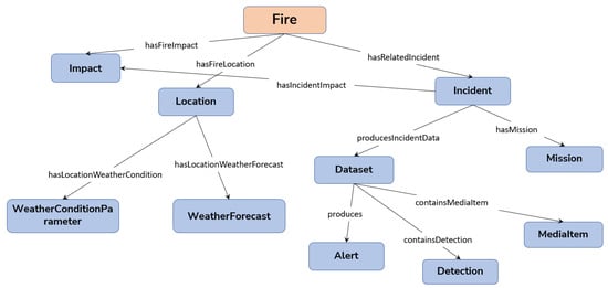
Figure 2.
Main classes in initial ONTO-SAFE ontology.
End-user participation in the creation of the ONTO-SAFE ontology is thought to be highly beneficial because it helps us to better understand end-user needs and expectations. Furthermore, the International User Requirements Workshop (IURW) and the online survey were used to identify and prioritize requirements. These two techniques were used to obtain comments from end-users such as police, firefighters, and wildfire managers, model the requirements through the competency questions [36] and transform them into semantic entities by providing the specification of the ONTO-SAFE ontological framework. The conduct of an extra survey during the first pilots of the project was deemed necessary to collect additional user needs. For this reason, additional classes and properties were added during the implementation of the work in order to better comply with the user requirements. Table 1 presents these additions to competency questions:

Table 1.
Sample CQs that the data should be able to answer.
The extended version of the ONTO-SAFE ontology aims to respond to user requirements that are mapped to CQs and capture information regarding weather anomalies, proper weather data for prescribed burning, and the decision support aspect. Thus, the updated version of ONTO-SAFE ontology contains:
- Weather and forecast anomalies of the Fire Weather Index (FWI), drought, duff moisture, and fine fuel moisture;
- Weather conditions of the prescribed burning process;
- Alerts and recommendations.
4.1. Representation of Weather and Forecast Anomalies
An anomaly refers to any occurrence that diverges from a typical form, contradicts expected patterns, or is generally perceived as unusual or peculiar in nature [37]. For all weather services, the forecast of significant weather events, such as wildfires, and associated anomalies is essential and provides important meteorological insight to a decision maker [38]. A representation of extreme weather forecasting information and anomalies is needed to understand the crisis and to allow different stakeholders to adopt and enable different early warning strategies. A well-known and popular indicator to estimate fire danger is the Canadian Forest Fire Weather Index (FWI) [39]. FWI belongs to the Canadian Forest Fire Weather Index System which comprises six standard components: three fuel moisture codes (Fine Fuel Moisture Code (FFMC), Duff Moisture Code (DMC), and Drought Code (DC)) and three fire behavior indexes (Initial Spread Index (ISI), Buildup Index (BUI), and Fire Weather Index (FWI)) [40]. The FWI, FFMC, DMC, and DC anomalies can be used to better assess the fire danger as historical values are calculated and analyzed from ONTO-SAFE’s sources (i.e., earth observations and weather forecasts). The results of this analysis transformed into RDF triples and populated the ONTO-SAFE ontology properly. The involved concepts for weather and forecast anomalies are visualized in Figure 3. The class Point is used to represent a point that presents some anomalies. Each point can have an FWI anomaly (via class FWIAnomaly), a Drought anomaly (via class DroughtAnomaly), a Duff Moisture anomaly (via class DuffMoistureAnomaly) and a Fine Fuel Moisture anomaly (via class FineFuelMoistureAnomaly) where the ontology presents numerous instances of the type Anomaly. In addition, each Point has a specific location (via class Location) and is linked with weather conditions (via class WeatherConditionParameter) and meteorological forecasts (via class WeatherForecast).
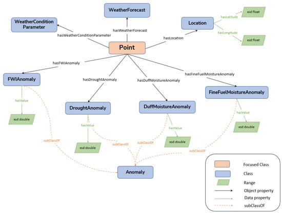
Figure 3.
Representation of weather and forecast anomalies in a specific point.
4.2. Representation of Weather Conditions of the Prescribed Burning Process
Planning and conducting a prescribed burning process is a challenge because of uncertainties in weather, fire behavior, and other factors [41]. A representation of the appropriate weather conditions in order to execute this process in a specific location is valuable. The involved concepts for the prescribed burning process are visualized in Figure 4. The class Location is used to present the location where the prescribed burning can be conducted. Suitable values for weather condition parameters (via class WeatherConditionParameter) including temperature (via class Temperature), humidity (via class Humidity), wind speed (via class WindSpeed) and precipitation (via class Precipitation) can enable the mission (via class Mission) for prescribed burning (via class PrescribedBurning).
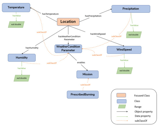
Figure 4.
Representation of weather conditions of the prescribed burning process in a specific location.
4.3. Representation of Alerts and Recommendations
After the analysis of data from ONTO-SAFE’s sources (sensors, weather forecasts, earth observations, etc.), the creation of alerts and recommendations facilitates decision support during forest fire disaster incidents. Having the proper information at the right time is critical while managing a disaster event. Therefore, the ultimate goal is to increase the efficiency of decision making while decreasing the required time. In this way, the representation of alerts and recommendations in order to assist decision support is essential. Figure 5 depicts the ontology’s core constructs for these entities.
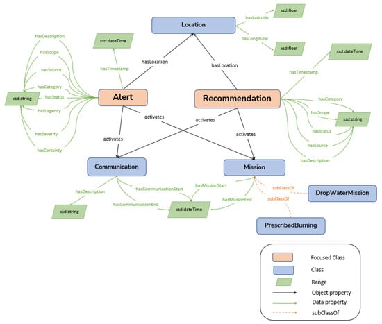
Figure 5.
Representation of alerts and recommendations.
Alerts and recommendations could be used to activate communication (via class Communication) to all citizens and also to activate missions (via class Mission) and assign these missions to first responders. The alert (via class Alert) is a quick notice for unusual and potentially dangerous or difficult circumstances and it is a Common Alerting Protocol (CAP)-compliant entity. On the other hand, the recommendation (via class Recommendation) is a purposed action suggested as suitable or appropriate, and it is a more text-based entity. Both entities can provide communication to a citizen or a professional and for certain actions or missions they can activate a mission. Moreover, alerts and recommendations can assist in the decision-making process by using the developed services. Citizens can be informed about dangerous situations in their area, and decision makers will be able to identify new incidents where there might be risk and decide the best solution for handling different types of alerts and recommendations.
Figure 6 depicts how the recommendation can activate communication in order to inform the professionals, if the conditions are appropriate, to conduct prescribed burning plan activities or not.

Figure 6.
Recommendation activates communication to avoid prescribed burning plans to a specific location.
5. Semantic Reasoning for Decision Support
In the context of wildfire events, the presence of a semantic reasoning approach becomes essential for effectively handling diverse knowledge and heterogeneous data. The development of a forest fire decision support system that is based on the semantic web is crucial to achieving its potential and enhancing the quality, safety, and efficiency of wildfire management. Semantic reasoning is a valuable component of the ONTO-SAFE framework as it aims to execute semantic queries on top of the ontology in order to retrieve alerts and recommendations that fulfill the criteria and return the results in an understandable format for decision-makers.
In our previous work [9], we introduced an initial ontology-based reasoning module designed to facilitate wildfire event management. We described how the proposed ontology addresses the specific requirements of end-users, supported by examples. In addition, we demonstrated the extraction of valuable location-specific information on wildfire incidents, including details such as the closest hospital and nearest water source in relation to the fire. Moreover, we presented the ability of the semantic reasoning module to extract new, enriched information, such as adding a proper mission in an incident. The decision makers are supported to send the proper equipment for this mission by the combination of data from in situ cameras and sensors.
The need to meet new user requirements led us to expand the semantic reasoning component and implement additional functionalities. The following subsections present the extension of the ONTO-SAFE’s semantic reasoning in the field of decision support for weather and forecast anomalies and for the prescribed burning process.
5.1. Decision Support for Weather and Forecast Anomalies
Weather and climate parameters control wildfire activity by regulating biomass growth and snowpack accumulation, which affects the availability of fire fuel, or, in the near term, by affecting the moisture content of vegetation and the duff layer and, consequently, their flammability [42]. To understand the situation and allow different stakeholders to adopt and enable different early warning techniques, extreme weather forecasting information and anomalies must be integrated into the decision support system. An implementation of a decision support module that takes as input these anomalies is useful for supporting the prevention phase and enhancing the emergency management system of wildfire events. The transformation of incoming data, including JSON and GeoJSON files, into RDF format for semantic representation is the foremost action of the semantic reasoning mechanism. The CQs concerning the anomalies are translated to GeoSPARQL queries executed in the ontology to retrieve alerts and recommendations that fulfill the proper criteria. A GeoSPARQL query on how we can define the areas via specific area codes—which have any anomaly of FWI, fine fuel moisture, duff moisture, or drought—is represented in Listing 1.
The query above retrieves information regarding the area code, the value of each anomaly, the timestamp, the region, and the polygon. All this information produces a JSON message that is visualized via a dashboard in order to inform the stakeholders to manage disaster risk better and minimize negative socio-economic impacts [43]. Figure 7 presents how the recommendations regarding the anomalies appear in Dashboard and show whether the recommendation is addressed to professionals or citizens for a specific location.
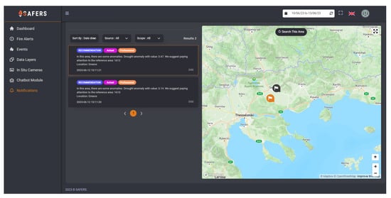
Figure 7.
Recommendations regarding the anomalies in dashboard.
| Listing 1. GeoSPARQL query regarding the anomalies in specific area. |
 |
5.2. Decision Support for Prescribed Burning Process
Prescribed burns are an invaluable tool in numerous countries to effectively manage the risk of fires, protect assets, safeguard lives, and restore landscapes [44]. A crucial challenge is determining how to organize the burns to maximize societal advantages. Safe and effective prescribed burns take expertise and careful planning. For this reason, fire authorities practice wildfire prevention based on values at risk, taking into account the differences in value and importance of communities, landscapes, houses, infrastructure, and natural resources [45].
Fire managers require decision support to organize the various stages of the burning season (management planning, the statistical, technical, and economic annual balance sheet of the burning season, etc.), as well as to carry out any given burning operation (burning feasibility, traps diagnostic, fire behavior, fire effects, etc.) [46]. In addition, knowledge of the meteorological conditions before, during, and after the operation is beneficial in order for managers to be able to design a prescribed burning properly.
The aim of the ONTO-SAFE framework, in the case of the prescribed burning process, is to enhance the knowledge of the conditions in order to conduct the prescribed burning via the visualization of this information and to assist fire managers in their decisions. The proper measurements before and during the application of the prescribed burns are crucial and should be correct in order to allow burning while not enabling fire to spread out of control [47]. Controlled fires are commonly operated as a method for vegetation management. They are used to achieve several essential objectives, including vegetation clearance, enhancement of pasture forage value, mitigation of wildfire hazards, and promotion of biodiversity conservation [48,49].
In our study, end users from the Catalonia region conducted experiments regarding the prescribed burning plans in the Canary Islands and Extremadura areas. Through their investigations and tests, they produced a range of weather conditions that must be met in order to carry out the burning process. It is important to note that the weather thresholds obtained from these experiments are not based on statistical analysis; instead, they serve as illustrative examples and are not meant to be universal or generalizable rules. The appropriateness of these thresholds can vary significantly depending on the specific burn objectives, such as the type and amount of vegetation targeted for burning, and the desired fire intensity. Additionally, site characteristics, including topography, local meteorology, and vegetation type and condition, also play a crucial role in determining the most suitable weather conditions for prescribed burning. As a result, the weather thresholds identified in this study may not be directly applicable to all geographical areas.
Seasonality is another important consideration in prescribing controlled burns. For instance, in Mediterranean regions, summer is generally considered an off-season for burning due to high temperatures and wind speeds, which makes it less conducive to controlled burns. In contrast, winter may offer more favorable conditions, as long as there is sufficient wind speed and relatively low relative humidity for the fire to spread effectively; although similarities in weather thresholds may exist across other Mediterranean countries, it is crucial to acknowledge that each country will adjust its prescribed burning plans according to its unique environmental and climatic conditions.
Table 2 presents the thresholds in temperature, humidity, and wind speed for the prescribed burning process in the Catalonia region, which is our study area. It is worth mentioning that all of the below variables must be measured in a way that the prescribed burning can only be conducted as long as they fit within the range established. Thus, the burning can be conducted as long as the variables fall within the full range. For instance, 10 degrees is the minimum temperature acceptable (if cooler than this, the fire will not be able to spread as desired), and 25 degrees is the maximum acceptable (if warmer than this, it may be too dangerous to set the fire).
Table 2.
Thresholds in temperature, humidity, and wind speed for prescribed burning process.
Taking into account the above thresholds, the population of the ontology in the appropriate classes carried out and the execution of GeoSPARQL queries (Listing 2) return the information with timestamps and values of temperature, humidity, and wind speed for the areas where the prescribed burn process can be conducted.
The results of these queries are transformed via semantic reasoning component to JSON and GeoJSON structures that are visualized via a dashboard in order to inform the decision makers whether the weather conditions are suitable to conduct the prescribed burns in specific areas and times.
Figure 8 shows how the JSON message is visualized as a recommendation in the dashboard, whereas the (Figure 9 and Figure 10) below show how the GeoJSON message is transformed into valuable maps.
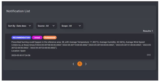
Figure 8.
Recommendations regarding the prescribed burning in dashboard.

Figure 9.
Polygon delineation of Catalonia area.
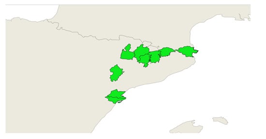
Figure 10.
Areas where the prescribed burning process can be conducted.
| Listing 2. GeoSPARQL query for the prescribed burning plan in specific area. |
 |
More specifically, the boundaries represented by the polygons depicted in Figure 9 play a crucial role in implementing an effective wildfire management strategy. These boundaries efficiently divide the entire area, enabling efficient forest fire management. Additionally, in Figure 10, the polygons highlighted in green indicate areas where weather conditions are suitable for conducting prescribed burns at specific times. The rest of the areas are not suitable for prescribed burning as the conditions are not favorable. This visual representation of areas significantly supports fire managers in their decision-making processes.
6. Evaluation
6.1. Qualitative Evaluation
For evaluating the quality of the ontology, we used OOPS! (OntOlogy Pitfall Scanner) [35], an online tool for detecting ontology pitfalls. The OOPS! tool provides an indicator for each pitfall and offers modifications to improve the ontology’s quality. The system identified three levels of pitfalls, namely, critical, important, and minor.
Table 3 presents the pitfalls detected by OOPS! for the ONTO-SAFE ontology, along with a brief description of their meaning and the number of cases for which they were specified. It is worth mentioning that no critical or important pitfall was detected for the ONTO-SAFE ontology.
Table 3.
Ontology pitfalls detected by OOPS!.
Concerning pitfall No1., OOPS! detected 132 cases where annotations and descriptions were missing. By adding human-readable comments to each given concept in the ontology, we were able to solve this issue and increase the expressiveness of the ontology through the use of the rdfs:label and rdfs:comment attributes. In addition, pitfall No2. warned about the lack of pairs of inverse properties for all of the ontology’s object properties (52 cases in total). To improve the completeness of the ontology, the pitfall was addressed by including the matching pairings of inverse properties.
6.2. Structural Ontology Evaluation
An important area of study in ontology engineering is ontology evaluation [50]. For evaluating the structure of ONTO-SAFE ontology with OntoMetrics [51] framework, the ontology was populated with data related to anomalies, weather forecasts, and prescribed burns. The OntoMetrics framework includes five types of ontology quality metrics: base, schema, knowledge base, class, and graph metrics. These metrics serve as indicators of ontology quality and are associated with various factors including accuracy, understandability, cohesion, computational efficiency, and conciseness [52]. Table 4 presents the results derived from the analysis by the OntoMetrics tool.
Table 4.
Ontology metrics produced by the OntoMetrics tool.
According to the OntoMetrics tool, base metrics are simple metrics that display the number of ontology elements, such as counting classes, axioms, objects, etc. Based on the total number of classes and characteristics, the suggested ontology can be characterized as a lightweight ontology that could be easily adopted by diverse applications where the full expressive power of a more complex ontology is not necessary or practical. In addition, DL expressivity is designed to describe and reason about structured knowledge in a formal and logical manner and indicates the Description Logic type of ontology. ONTO-SAFE ontology is under the expressivity of the AL(D) Description Logic, which indicates that it can be suitable for various applications, as AL is the base language and the smallest DL language that can be detected by reasoners (e.g., Pellet) [53].
Regarding the schema metrics, they are concerned with the design of the ontology. Metrics in this category show an ontology schema design’s richness, width, depth, and inheritance. Attribute richness refers to the average number of attributes per class and can be used as a metric for evaluating both the efficacy of an ontology’s design and the volume of information that is pertinent to instance data. The greater the number of qualities defined, the more knowledge the ontology provides. The inheritance richness metric describes how information is distributed across different levels of the ontology’s inheritance tree. This is a reliable indication of how well the ontology organizes knowledge into various categories and subcategories. This value for ONTO-SAFE ontology is above the middle levels, which indicates that the conception level is sufficient. Relationship richness is determined by dividing the count of non-inheritance relationships (such as object properties, equivalent classes, and disjoint classes) by the total number of relationships specified in the schema. This measure indicates how diverse the ontology’s relation types are. For instance, in the case that ontology includes only inheritance relationships, it represents less information compared with an ontology with diverse relationships.
In addition, the knowledgebase metrics are based on the instance metrics, which are used to calculate the quantity of real-world knowledge represented by the ontology. The average population metric indicates the number of instances in relation to the number of classes. The result shows how successfully the data extraction procedure was carried out in order to populate the knowledge base. The respective value of this metric in the proposed ontology is high which indicates that the knowledge represented is more than satisfactory. Finally, the class richness metric can be represented as the percentage of non-empty classes (classes with instances) to the total number of classes specified in the ontology schema. In the proposed ontology the value of this metric is quite low because all the class knowledge is not utilized as only the ONTO-SAFE aspects related to anomalies, weather forecasts, and prescribed burns were presented.
6.3. Quantitative Evaluation
A real-world dataset was taken into consideration for the quantitative evaluation and responsiveness of the suggested reasoning framework. The dataset was produced during the demonstration of the reasoning framework which took place in different pilot areas on behalf of the SAFERS [54] European-funded project and includes weather and forecasted anomalies of FWI, fine fuel moisture, duff moisture, and drought, polygons, and multipolygons for the studied regions (Corsica, Central Macedonia, Catalonia, and Piedmont).
To measure the response times for every region, the number of polygons and multipolygons for each area was needed, as each region has its own fire management areas. For this reason, we collect 17 polygons for the Corsica area, 18 multipolygons for Central Macedonia, 42 polygons and multipolygons for Catalonia, and 56 multipolygons for Piedmont. For every fire management area, the ONTO-SAFE framework populates the ONTO-SAFE ontology with weather-related data which are received as input from weather forecast-related services. The ONTO-SAFE knowledge graphs consist of 61K statements in Knowledge Base Repository. The reasoning semantic analysis process starts after the population of ontology, as the proper queries are executed in ontology and the relative recommendations are retrieved. The reasoning response time for every region and the number of recommendations that are produced after the execution of the semantics queries are depicted in Figure 11.
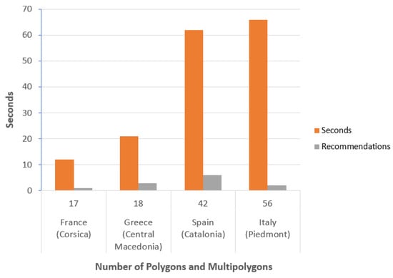
Figure 11.
Reasoning response time for every region.
The performance of the ONTO-SAFE reasoning module was characterized positively by end users as the response time, according to the number of polygons, was increased but in a perfectly reasonable manner. The reason is that the more polygons that have to be examined, the more queries will be executed to the knowledge base. Moreover, the increment in the quantity of generated recommendations also leads to a minimal impact on response time relative to the number of polygons and multipolygons.
Furthermore, in order to improve the performance and efficiency of the ONTO-SAFE framework, we used the Douglas–Peucker algorithm to simplify polygons associated with pilot forest fire areas. This algorithm effectively reduces the complexity of the polygons while preserving their essential shape and characteristics. As a direct outcome of this simplification, we were able to optimize the processing time of our framework, ONTO-SAFE. To evaluate the framework’s processing time and scalability, we conducted a testing process that involved applying the reasoning semantic analysis to four distinct forest areas. We measured the processing time in seconds (s) both before and after implementing the Douglas–Peucker algorithm, and the results are summarized in Table 5.
Table 5.
Processing time (s) before and after the usage of the Douglas–Peucker algorithm per area.
It is worth noting that the observed reduction in polygon complexity has significantly expedited the analysis and decision-making procedures, especially in emergency situations. This improvement plays a vital role in enhancing the overall effectiveness of firefighting efforts.
7. Discussion
This study presents an ontology-based approach to enhance information sharing among stakeholders and facilitate advanced whereas in forest fire emergencies. The proposed approach provides a framework that uses a common, shared vocabulary and reasoning mechanism in order to assist decision-makers to make informed decisions.
Related ontologies and ontology-based systems for emergencies were investigated structurally and modularly to describe the conceptual model of the underlying KGs at various levels. Several concepts and classes were reused from relative ontologies such as classes Fire, Impact, Location, Report, etc., from Empathi [23] ontology; classes Fire, Incident, WeatherConditions, and Communication from EmergencyFire [28] ontology; classes Incident, Impact, Location, Dataset, Mission, etc., from BeAWARE [32] ontology; and classes related to Topography and Vegetation from OntoFire [31] ontology. For depicting damages and their relationship to resources in order to categorize damages and resources, our strategy is based on the SoKNOS [22] approach.
Not all concepts and classes from related ontologies were used due to the fact that many of them, such as EmergencyFire [28] ontology, were focused only on fire emergencies in buildings, and our target domain focuses on forest fires. In addition, BACAREX [29] ontology was not used because as a heavyweight ontology, it is complex and difficult to comprehend due to its extensive structure and a vast amount of information. Likewise, the geo-ontology [30] was not used because no evaluation of those terms was carried out to verify their semantic accuracy although it is a very interesting multi-level ontology model and its focus relies on meteorological disasters.
Furthermore, in this paper, we demonstrate the analysis results of weather anomalies that were represented in different regions. Data refer to pilot regions in Corsica, Central Macedonia, Catalonia, and Piedmont. We execute the related anomalies rules on top of the ONTO-SAFE domain ontology to investigate what recommendations will actually be produced when the appropriate weather variables significantly exceed a normal level. The performance of the ONTO-SAFE reasoning module in these areas was characterized positively by end users and the evaluated results imply that the ONTO-SAFE framework can be optimized for large-scale implementation.
Additionally, in order to evaluate the framework’s processing time and scalability, we used the Douglas–Peucker algorithm to simplify polygons for forest fire areas. This algorithm effectively reduces the complexity of the polygons, leading to a more concise representation of the data while retaining essential information. By implementing this optimization, we have significantly enhanced the scalability of our framework, resulting in reduced time consumption for processing and handling large datasets. This optimization contributes to more efficient decision-making processes, as it enables quicker data analysis and improved resource utilization. As a result, the proposed ontology-based framework can provide support by generating recommendations in different disaster risk management phases and assisting in significant activities such as prescribed burning processes. Furthermore, the ONTO-SAFE framework can be adaptable and expandable for any kind of natural disasters, such as floods, earthquakes, etc., as the ontology model promotes expressiveness and sustainability over the standard expert system.
In addition, it is important to note that the ONTO-SAFE framework operates as a rule-based system, with rules based on user requirements and domain expertise. Consequently, both the rules and the outputs of the framework are inherently subjective, as they are customized to address specific needs and objectives. It is crucial to recognize that the effectiveness of our framework is significantly affected by the quality and accuracy of the input data derived from diverse sources. In the event of any concerns regarding data quality or potential biases within the input information, it is essential to acknowledge that they may impact the outcomes of the framework correspondingly.
However, it is important to note that although response time optimization with the Douglas–Peucker algorithm is beneficial, it should not compromise the accuracy of the decision-making process. Achieving the right balance between response time and accuracy is a crucial aspect of system design, as it guarantees prompt response while upholding reliability and precision.
Moreover, the proposed framework is designed to protect user data and maintain transparency in all interactions. Data privacy and security have been given paramount importance throughout the entire development of the project platform, as citizens’ personal data are not accessible. The only data that are accessible is the information inserted by registered users during their registration process, which is subject to their consent and acceptance of our comprehensive privacy policy. Furthermore, when the ONTO-SAFE framework shares information with citizens and professionals, we ensure that no personal data are included. The only information that is shared is the location that users confirm to share with us, solely for the purpose of providing them with more accurate assistance.
For future work, the ONTO-SAFE framework could be extended to consider the integration with real-time data streams and advanced analytics techniques, including machine learning algorithms. By incorporating real-time data, the proposed framework can enhance the accuracy and timeliness of decision support during forest fire emergencies. Real-time data sources such as weather conditions, satellite imagery, and sensor networks can provide valuable information for more precise fire behavior modeling and risk assessment. Additionally, the integration of machine learning algorithms can enable the framework to learn from historical fire data, identify patterns, and make predictions for improved whereas. Exploring these capabilities will lead to a further enhancement of the framework’s adaptability and effectiveness in handling dynamic and evolving fire situations.
8. Conclusions
In this paper, we have proposed and showcased a semantic ONTO-SAFE framework that acts as a supporting tool in the decision-making process to prevent a wildfire event. The framework can significantly support decision-making issues by providing valuable information to relevant stakeholders (first responders, decision makers, organization managers, etc.) to detect possible wildfire events or the appropriate conditions to conduct the prescribed burning process. Moreover, the study demonstrated how the suggested ontology meets the needs of end users by presenting an ontology-based reasoning module for wildfire event management. In addition, the evaluation of the ONTO-SAFE framework shows that it can be optimized for large-scale implementation. Future work includes a) the extension of the proposed framework to similar situations corresponding to other forest regions in order to demonstrate the semantic reasoning techniques, b) the enrichment of our reasoning services to optimize the response time in order to support the decision-making process more effectively, and c) the integration of machine learning algorithms in order to enhance the framework’s effectiveness in handling forest fire situations.
Author Contributions
Conceptualization, P.M., S.K. and Z.V.; methodology, P.M., Z.V. and G.M.; software, P.M.; validation, P.M., Z.V. and G.M.; formal analysis, P.M.; investigation, P.M. and G.M.; writing—original draft preparation, P.M., S.K. and Z.V.; writing—review and editing, G.M., S.V. and I.K.; visualization, P.M.; supervision, S.K., S.V. and I.K.; project administration, S.V. and I.K. All authors have read and agreed to the published version of the manuscript.
Funding
This research was funded by the EC under contracts H2020-869353 SAFERS and H2020-101021957 NIGHTINGALE.
Institutional Review Board Statement
Not applicable.
Informed Consent Statement
Not applicable.
Data Availability Statement
Not applicable.
Acknowledgments
The authors would like to thank David Martin from the Pau Costa Foundation (PCF), who shared with them the results from their experiments that have been conducted regarding the prescribed burning plans in the Canary Islands and Extremadura areas in order to use them for testing the suggested framework.
Conflicts of Interest
The authors declare no conflict of interest.
Abbreviations
The following abbreviations are used in this manuscript:
| AL | Attributive Language |
| BUI | Buildup Index |
| CAP | Common Alerting Protocol |
| DC | Drought Code |
| DL | Description Logic |
| DMC | Duff Moisture Code |
| FFMC | Fine Fuel Moisture Code |
| FWI | Fire Weather Index |
| ISI | Initial Spread Index |
| KBP | Knowledge Base Population |
| KBR | Knowledge Base Repository |
| KBS | Knowledge Base Service |
| OWL | Web Ontology Language |
| RDF | Resource Description Framework |
| SPARQL | Simple Protocol and RDF Query Language |
| URI | Uniform Resource Identifier |
| WWW | World Wide Web |
| W3C | World Wide Web Consortium |
References
- Khabarov, N.; Krasovskii, A.; Obersteiner, M.; Swart, R.; Dosio, A.; San-Miguel-Ayanz, J.; Durrant, T.; Camia, A.; Migliavacca, M. Forest fires and adaptation options in Europe. Reg. Environ. Chang. 2016, 16, 21–30. [Google Scholar] [CrossRef]
- Wilson, R.S.; Winter, P.L.; Maguire, L.A.; Ascher, T. Managing wildfire events: Risk-based decision making among a group of federal fire managers. Risk Anal. Int. J. 2011, 31, 805–818. [Google Scholar] [CrossRef] [PubMed]
- Wunder, S.; Calkin, D.E.; Charlton, V.; Feder, S.; de Arano, I.M.; Moore, P.; y Silva, F.R.; Tacconi, L.; Vega-García, C. Resilient landscapes to prevent catastrophic forest fires: Socioeconomic insights towards a new paradigm. For. Policy Econ. 2021, 128, 102458. [Google Scholar] [CrossRef]
- Kotroni, V.; Cartalis, C.; Michaelides, S.; Stoyanova, J.; Tymvios, F.; Bezes, A.; Christoudias, T.; Dafis, S.; Giannakopoulos, C.; Giannaros, T.M.; et al. DISARM early warning system for wildfires in the eastern Mediterranean. Sustainability 2020, 12, 6670. [Google Scholar] [CrossRef]
- Blomqvist, E. The use of Semantic Web technologies for decision support—A survey. Semant. Web 2014, 5, 177–201. [Google Scholar] [CrossRef]
- Gordon, S.N.; Murphy, P.J.; Gallo, J.A.; Huber, P.; Hollander, A.; Edwards, A.; Jankowski, P. People, Projects, Organizations, and Products: Designing a Knowledge Graph to Support Multi-Stakeholder Environmental Planning and Design. Isprs Int. J. Geo-Inf. 2021, 10, 823. [Google Scholar] [CrossRef]
- Mhammedi, S.; Gherabi, N. Heterogeneous integration of big data using semantic web technologies. In Intelligent Systems in Big Data, Semantic Web and Machine Learning; Springer: Cham, Switzerland, 2021; pp. 167–177. [Google Scholar]
- Gupta, J.N.; Forgionne, G.A.; Mora T, M.; Lu, J.; Roberts, C.; Lang, K.; Stirling, A.; Madelin, K. The Application of Semantic Web Technologies for Railway Decision Support. In Intelligent Decision-Making Support Systems: Foundations, Applications and Challenges; Springer: London, UK, 2006; pp. 321–337. [Google Scholar]
- Masa, P.; Meditskos, G.; Kintzios, S.; Vrochidis, S.; Kompatsiaris, I. Ontology-based Modelling and Reasoning for Forest Fire Emergencies in Resilient Societies. In Proceedings of the 12th Hellenic Conference on Artificial Intelligence, Corfu, Greece, 7–9 September 2022; pp. 1–9. [Google Scholar]
- Berners-Lee, T.; Hendler, J.; Lassila, O. The semantic web. Sci. Am. 2001, 284, 34–43. [Google Scholar] [CrossRef]
- Fisher, M.; Blace, R.; Hebeler, J.; Perez-Lopez, A. Semantic Web Programming; John Wiley & Sons: Hoboken, NJ, USA, 2011. [Google Scholar]
- Davies, J.; Fensel, D.; Van Harmelen, F. Towards the semantic web. In Ontology-Driven Knowledge Management; John Wiley & Sons: Hoboken, NJ, USA, 2003. [Google Scholar]
- Fensel, D.; Fensel, D. Ontologies; Springer: Berlin/Heidelberg, Germany, 2001. [Google Scholar]
- Miller, E. An Introduction to the Resource Description Framework. J. Libr. Adm. 2001, 34, 245–255. [Google Scholar] [CrossRef]
- Pan, J.Z. Resource description framework. In Handbook on Ontologies; Springer: Berlin/Heidelberg, Germany, 2009; pp. 71–90. [Google Scholar]
- Schenk, S.; Staab, S. Networked graphs: A declarative mechanism for SPARQL rules, SPARQL views and RDF data integration on the web. In Proceedings of the 17th International Conference on World Wide Web, Beijing, China, 21–25 April 2008; pp. 585–594. [Google Scholar]
- Ma, L.; Yang, Y.; Qiu, Z.; Xie, G.; Pan, Y.; Liu, S. Towards a complete OWL ontology benchmark. In Proceedings of the The Semantic Web: Research and Applications: 3rd European Semantic Web Conference, ESWC 2006, Budva, Montenegro, 11–14 June 2006; Proceedings 3. Springer: Berlin/Heidelberg, Germany, 2006; pp. 125–139. [Google Scholar]
- Horrocks, I.; Patel-Schneider, P.F. Reducing OWL entailment to description logic satisfiability. In Proceedings of the The Semantic Web-ISWC 2003: Second International Semantic Web Conference, Sanibel Island, FL, USA, 20–23 October 2003; Proceedings 2. Springer: Berlin/Heidelberg, Germany, 2003; pp. 17–29. [Google Scholar]
- McGuinness, D.L.; Van Harmelen, F. OWL web ontology language overview. W3C Recomm. 2004, 10, 2004. [Google Scholar]
- De Bruijn, J.; Lara, R.; Polleres, A.; Fensel, D. OWL DL vs. OWL Flight: Conceptual modeling and reasoning for the semantic web. In Proceedings of the 14th international conference on World Wide Web, Chiba, Japan, 10–14 May 2005; pp. 623–632. [Google Scholar]
- Harris, S.; Seaborne, A.; Prud’hommeaux, E. SPARQL 1.1 query language. W3C Recomm. 2013, 21, 778. [Google Scholar]
- Babitski, G.; Bergweiler, S.; Grebner, O.; Oberle, D.; Paulheim, H.; Probst, F. SoKNOS-Using Semantic Technologies in Disaster Management Software. In Proceedings of the ESWC (2), Crete, Greece, 29 May–2 June 2011; pp. 183–197. [Google Scholar]
- Gaur, M.; Shekarpour, S.; Gyrard, A.; Sheth, A. empathi: An ontology for emergency managing and planning about hazard crisis. In Proceedings of the IEEE 13th International Conference on Semantic Computing (ICSC), Newport Beach, CA, USA, 30 January 2019–1 February 2019; pp. 396–403. [Google Scholar]
- Brickley, L.M.D. FOAF Vocabulary Specification. 2004. Available online: http://xmlns.com/foaf/0.1/ (accessed on 17 July 2023).
- SIOC Core Ontology Specification. 2007. Available online: https://www.w3.org/Submission/sioc-spec/ (accessed on 17 July 2023).
- DCMI Metadata Terms. 2020. Available online: https://www.dublincore.org/specifications/dublin-core/dcmi-terms/ (accessed on 17 July 2023).
- LODE: An ontology for Linking Open Descriptions of Events. 2021. Available online: https://linkedevents.org/ontology/ (accessed on 18 July 2023).
- Bitencourt, K.; Durao, F.A.; Mendonca, M.; Santana, L.L.B.D.S. An ontological model for fire emergency situations. IEICE Trans. Inf. Syst. 2018, 101, 108–115. [Google Scholar] [CrossRef]
- de la Asunción, M.; Castillo, L.; Fdez-Olivares, J.; García-Pérez, Ó.; González, A.; Palao, F. SIADEX: An interactive knowledge-based planner for decision support in forest fire fighting. AI Commun. 2005, 18, 257–268. [Google Scholar]
- Zhong, S.; Fang, Z.; Zhu, M.; Huang, Q. A geo-ontology-based approach to decision-making in emergency management of meteorological disasters. Nat. Hazards 2017, 89, 531–554. [Google Scholar] [CrossRef]
- Kalabokidis, K.; Athanasis, N.; Vaitis, M. OntoFire: An ontology-based geo-portal for wildfires. Nat. Hazards Earth Syst. Sci. 2011, 11, 3157–3170. [Google Scholar] [CrossRef]
- Kontopoulos, E.; Mitzias, P.; Moßgraber, J.; Hertweck, P.; van der Schaaf, H.; Hilbring, D.; Lombardo, F.; Norbiato, D.; Ferri, M.; Karakostas, A.; et al. Ontology-based Representation of Crisis Management Procedures for Climate Events. In Proceedings of the ISCRAM, Rochester NY, USA, 20–23 May 2018. [Google Scholar]
- beAWARE. Available online: https://beaware-project.eu/ (accessed on 18 July 2023).
- Limbu, M.K. Integration of Crowdsourced Information with Traditional Crises and Disaster Management Information Using Linked Data. Marter’s Thesis, Institute for Geoinformatics, University of Muenster, Muenster, Germany, 2012. [Google Scholar]
- Poveda-Villalón, M.; Gómez-Pérez, A.; Suárez-Figueroa, M.C. Oops!(ontology pitfall scanner!): An on-line tool for ontology evaluation. Int. J. Semant. Web Inf. Syst. 2014, 10, 7–34. [Google Scholar] [CrossRef]
- Grüninger, M.; Fox, M.S. The role of competency questions in enterprise engineering. In Benchmarking—Theory and Practice; Springer: Boston, MA, USA, 1995; pp. 22–31. [Google Scholar]
- Trickett, S.B.; Trafton, J.G.; Schunn, C.D. How do scientists respond to anomalies? Different strategies used in basic and applied science. Top. Cogn. Sci. 2009, 1, 711–729. [Google Scholar] [CrossRef]
- Grumm, R.H.; Hart, R. Standardized anomalies applied to significant cold season weather events: Preliminary findings. Weather. Forecast. 2001, 16, 736–754. [Google Scholar] [CrossRef]
- Van Wagner, C.E. Structure of the Canadian Forest Fire Weather Index; Environment Canada, Forestry Service: Ottawa, ON, Canada, 1974; Volume 1333. [Google Scholar]
- Lawson, B.D.; Armitage, O. Weather Guide for the Canadian Forest Fire Danger Rating System; Canadian Forest Service Northern Forestry Centre: Ottawa, ON, Canada, 2008. [Google Scholar]
- Cohan, D.; Haas, S.M.; Radloff, D.L.; Yancik, R.F. Using fire in forest management: Decision making under uncertainty. Interfaces 1984, 14, 8–19. [Google Scholar] [CrossRef]
- Grillakis, M.; Voulgarakis, A.; Rovithakis, A.; Seiradakis, K.D.; Koutroulis, A.; Field, R.D.; Kasoar, M.; Papadopoulos, A.; Lazaridis, M. Climate drivers of global wildfire burned area. Environ. Res. Lett. 2022, 17, 045021. [Google Scholar] [CrossRef]
- Jolly, W.M.; Cochrane, M.A.; Freeborn, P.H.; Holden, Z.A.; Brown, T.J.; Williamson, G.J.; Bowman, D.M. Climate-induced variations in global wildfire danger from 1979 to 2013. Nat. Commun. 2015, 6, 7537. [Google Scholar] [CrossRef]
- Florec, V.; Burton, M.; Pannell, D.; Kelso, J.; Milne, G. Where to prescribe burn: The costs and benefits of prescribed burning close to houses. Int. J. Wildland Fire 2019, 29, 440–458. [Google Scholar] [CrossRef]
- Williams, K.J.; Ford, R.M.; Rawluk, A. Values of the public at risk of wildfire and its management. Int. J. Wildland Fire 2018, 27, 665–676. [Google Scholar] [CrossRef]
- Rigolot, E.; Gaulier, A.; Vauche, D.; Guarnieri, F. Toward a prescribed burning decision support system for the French Mediterranean region. In Proceedings of the 13th Conference on Fire and Meteorology: International Perspectives on Landscape Fire, Lorne, Australia, 27–31 October 1996; Volume 27, p. e31. [Google Scholar]
- Pastro, L.A.; Dickman, C.R.; Letnic, M. Burning for biodiversity or burning biodiversity? Prescribed burn vs. wildfire impacts on plants, lizards, and mammals. Ecol. Appl. 2011, 21, 3238–3253. [Google Scholar] [CrossRef]
- Letnic, M. Cattle grazing in a hummock grassland regenerating after fire: The short-term effects of cattle exclusion on vegetation in south-western Queensland. Rangel. J. 2004, 26, 34–48. [Google Scholar] [CrossRef]
- Valentine, L.E.; Schwarzkopf, L. Effects of weed-management burning on reptile assemblages in Australian tropical savannas. Conserv. Biol. 2009, 23, 103–113. [Google Scholar] [CrossRef] [PubMed]
- Fonou-Dombeu, J.V.; Viriri, S. OntoMetrics evaluation of quality of e-government ontologies. In Proceedings of the Electronic Government and the Information Systems Perspective: 8th International Conference, EGOVIS 2019, Linz, Austria, 26–29 August 2019; Proceedings 8. Springer: Cham, Switzerland, 2019; pp. 189–203. [Google Scholar]
- OntoMetrics. Available online: https://ontometrics.informatik.uni-rostock.de/ontologymetrics/ (accessed on 18 July 2023).
- Lantow, B. OntoMetrics: Putting Metrics into Use for Ontology Evaluation. In Proceedings of the KEOD, Porto, Portugal, 9–11 November 2016; pp. 186–191. [Google Scholar]
- d’Aquin, M.; Baldassarre, C.; Gridinoc, L.; Angeletou, S.; Sabou, M.; Motta, E. Characterizing knowledge on the semantic web with watson, Busan, South Korea. In Proceedings of the Evaluation of Ontologies and OntologyBased Tools: 5th International EON Workshop, Busan, Republic of Korea, 11 November 2007. [Google Scholar]
- SAFERS. Available online: https://safers-project.eu/ (accessed on 18 July 2023).


Disclaimer/Publisher’s Note: The statements, opinions and data contained in all publications are solely those of the individual author(s) and contributor(s) and not of MDPI and/or the editor(s). MDPI and/or the editor(s) disclaim responsibility for any injury to people or property resulting from any ideas, methods, instructions or products referred to in the content. |
© 2023 by the authors. Licensee MDPI, Basel, Switzerland. This article is an open access article distributed under the terms and conditions of the Creative Commons Attribution (CC BY) license (https://creativecommons.org/licenses/by/4.0/).