An Ensemble Broad Learning System (BLS) for Evaluating Landslide Susceptibility in Taiyuan City, Northern China
Abstract
1. Introduction
2. Study Area and Data Used
2.1. Study Area
2.2. Data Used
3. Modeling Approaches
3.1. Training and Validation Datasets
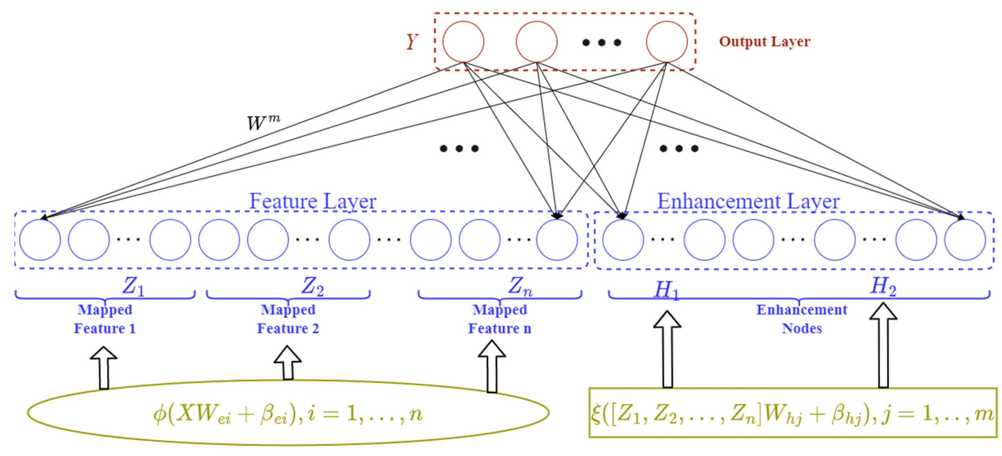
3.2. Broad Learning System (BLS)
3.3. Support Vector Machine (SVM)
3.4. Classification and Regression Trees (CART)
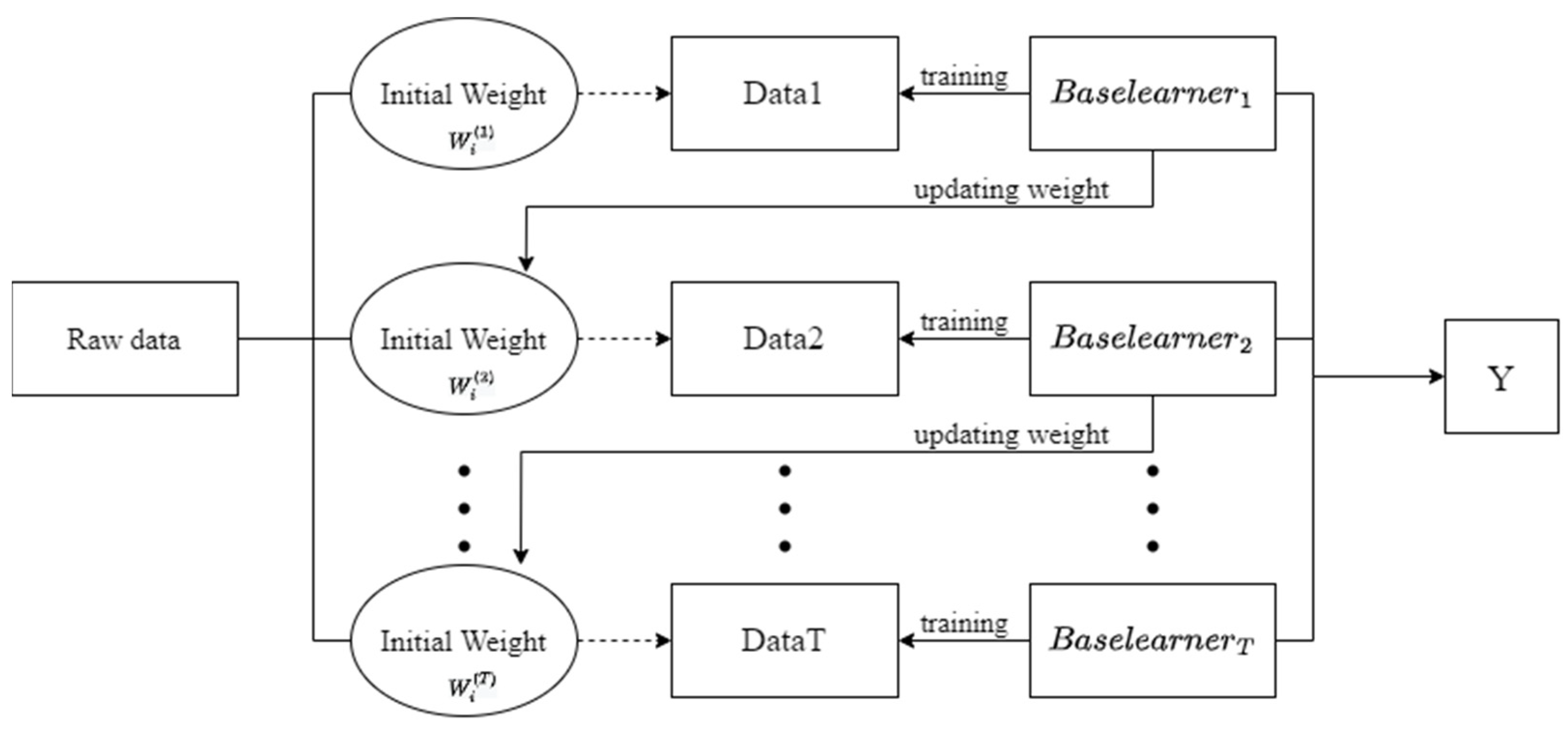
3.5. Adaptive Boosting (AdaBoost)
3.6. Selection of Landslide Conditioning Factors
3.7. Evaluation of the Models’ Performance
3.7.1. Statistical Index-Based Evaluations
3.7.2. Receiver Operating Characteristic (ROC)
4. Results and Discussion
4.1. Relationships between Landslides and the Related Factors
4.2. Selection of Landslide Conditioning Factors
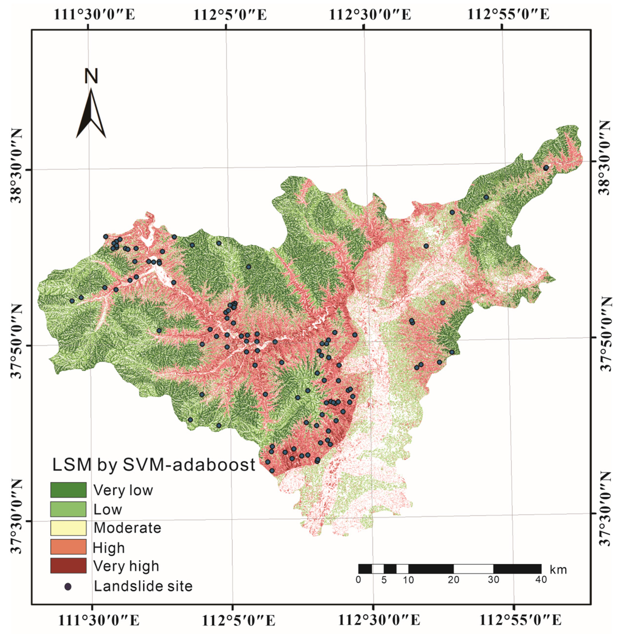
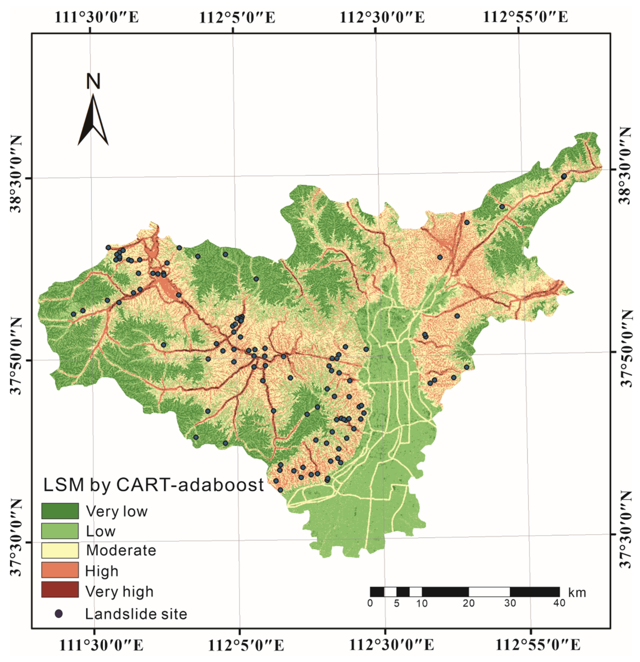
4.3. Building the Ensemble Models and Constructing Landslide Susceptibility Maps
4.4. Validation of the Landslide Susceptibility Maps
5. Discussion
6. Conclusions
- (1)
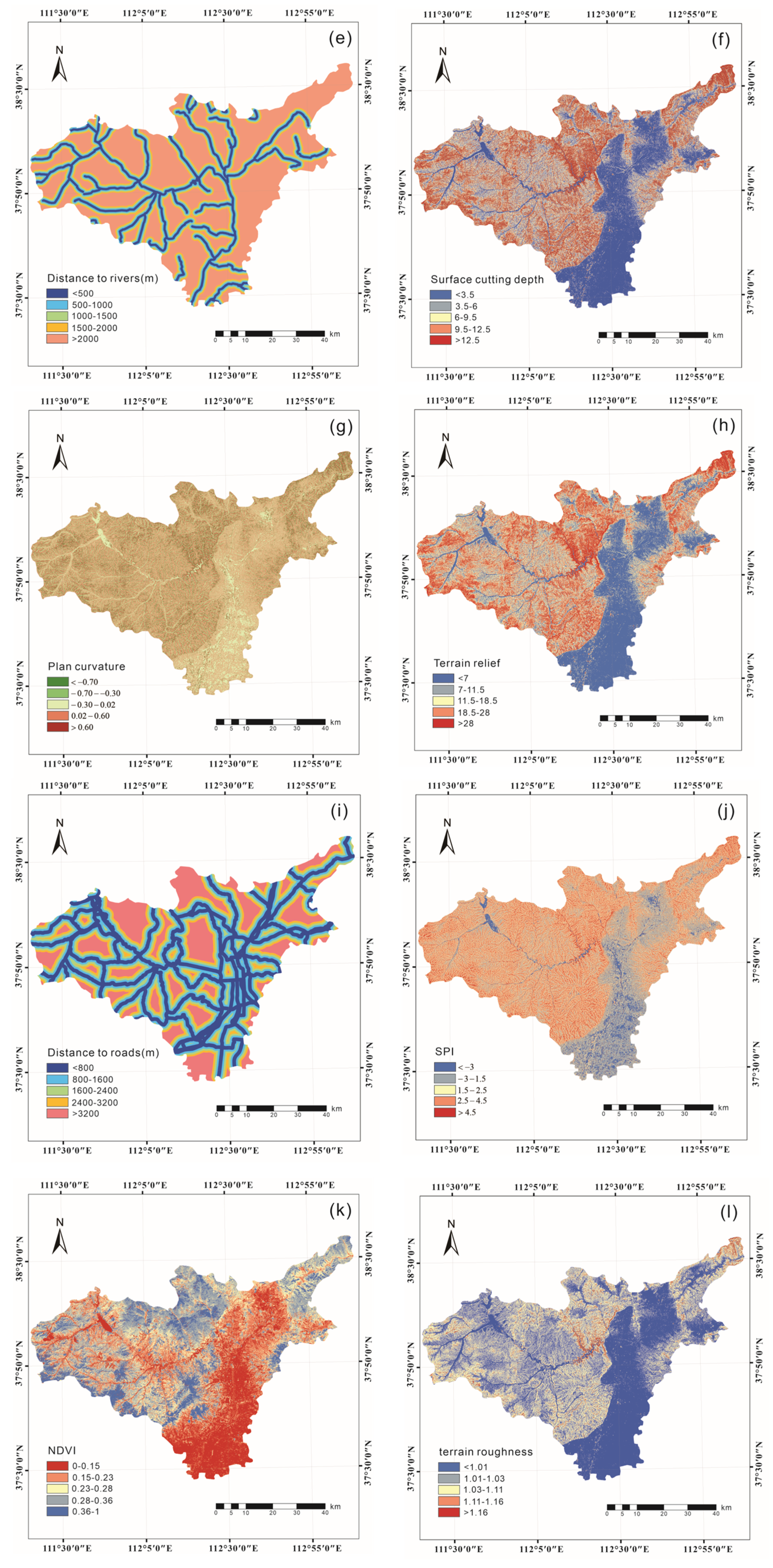
- According to the results of the FR, most landslides occurred at elevations of 941–1193 m, slopes of 6, distances to rivers of <500 m, distances to roads of <800 m, slopes with a southeast aspect, SPI values of 2.4–4.5, TWI values of <5, NDVI values of 0.15–0.23, plan curvatures of −0.7–−0.3, surface cutting depths of 6–9.5, terrain roughness values of 1.03–1.11 and terrain relief values of 11.5–18.5.
- (2)
- In total, 12 landslide impact factors were identified and assessed on the basis of their VI values. The most important impact factor was elevation, followed by NDVI, TWI, curvature, distance to rivers, distance to roads, SPI, slope aspect, terrain roughness index, slope, surface cutting depth and terrain relief.
- (3)
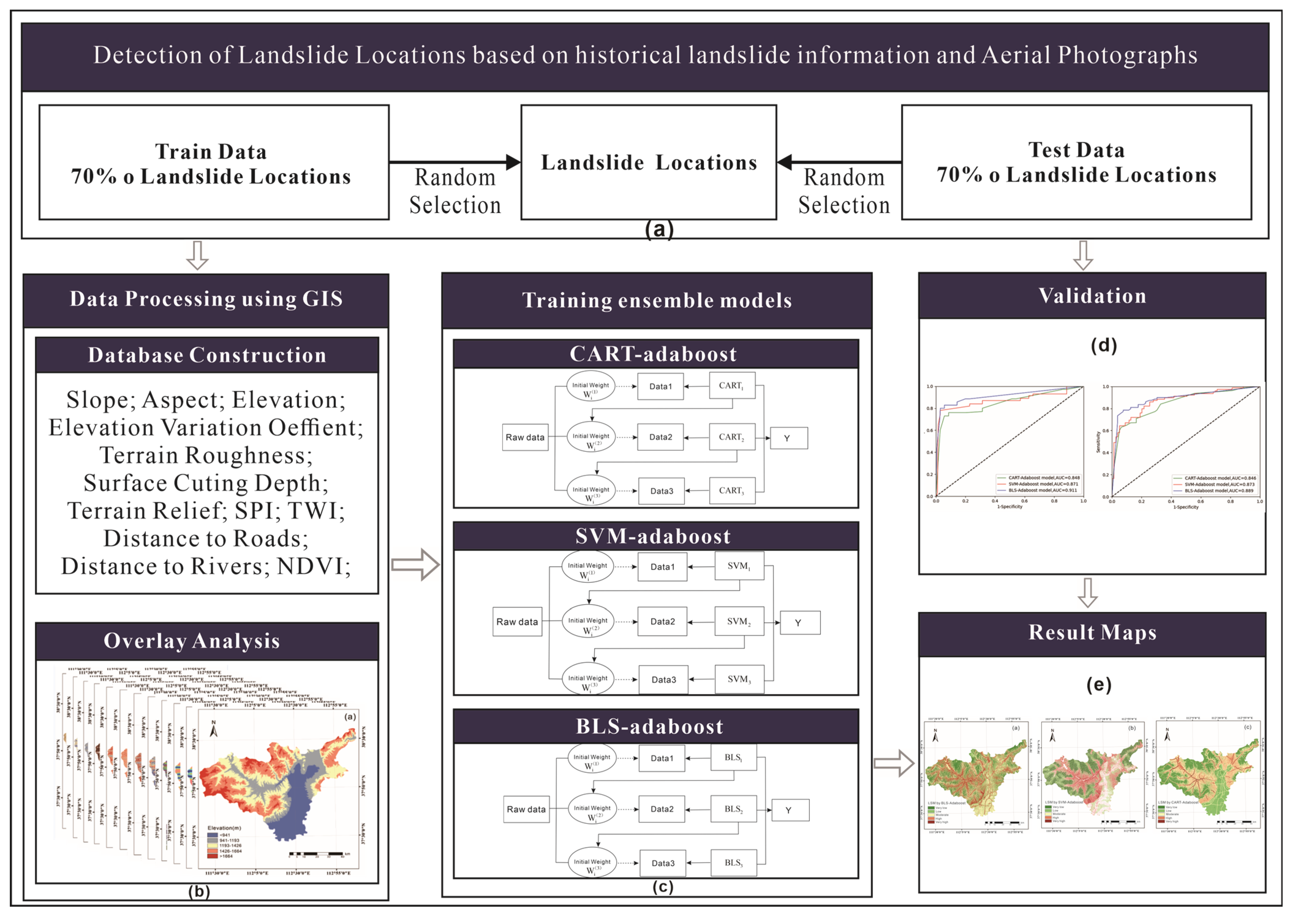
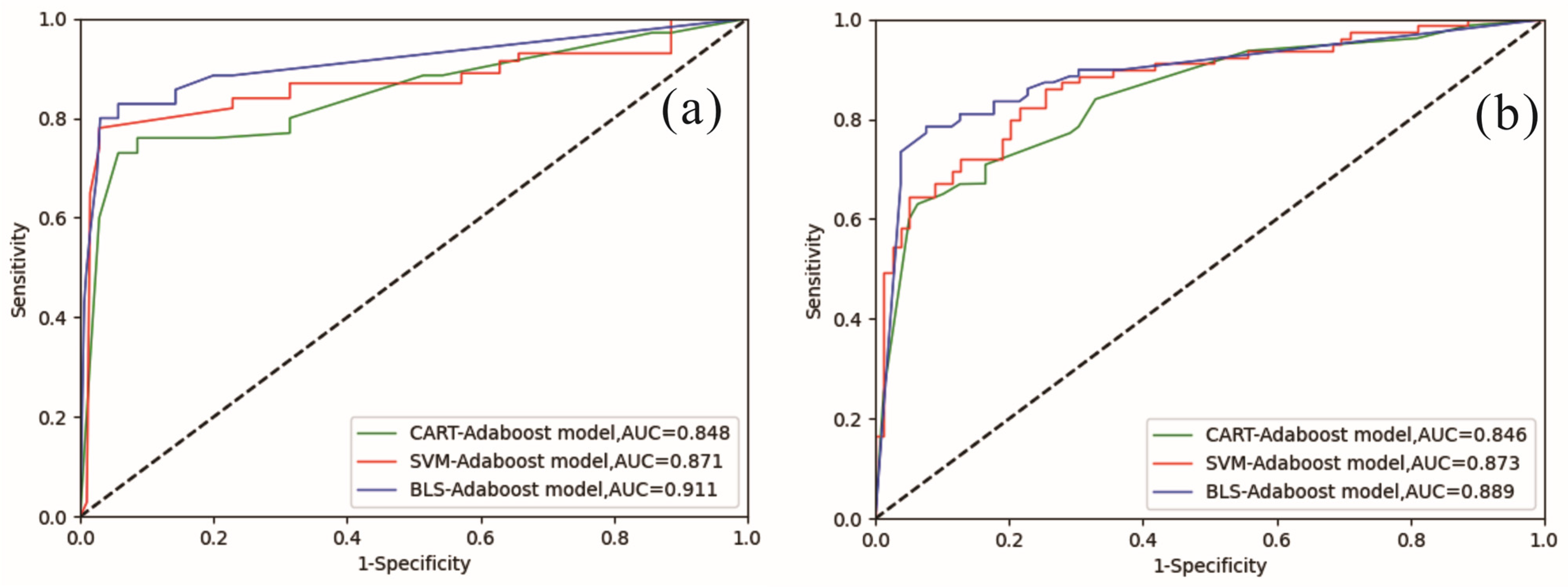
- The three models (CART-AdaBoost, SVM-AdaBoost, and BLS-AdaBoost) were evaluated and compared by statistical methods and AUC. All three methods had good results, but it is evident from the results that the method proposed in this study, utilizing ensemble BLS, outperformed the other two methods.
Author Contributions
Funding
Institutional Review Board Statement
Informed Consent Statement
Data Availability Statement
Conflicts of Interest
References
- Hong, H.; Panahi, M.; Shirzadi, A.; Ma, T.; Liu, J.; Zhu, A.-X.; Chen, W.; Kougias, I.; Kazakis, N. Flood Susceptibility Assessment in Hengfeng Area Coupling Adaptive Neuro-Fuzzy Inference System with Genetic Algorithm and Differential Evolution. Sci. Total Environ. 2018, 621, 1124–1141. [Google Scholar] [CrossRef] [PubMed]
- Huang, Y.; Zhao, L. Review on Landslide Susceptibility Mapping Using Support Vector Machines. CATENA 2018, 165, 520–529. [Google Scholar] [CrossRef]
- Merghadi, A.; Yunus, A.P.; Dou, J.; Whiteley, J.; ThaiPham, B.; Bui, D.T.; Avtar, R.; Abderrahmane, B. Machine Learning Methods for Landslide Susceptibility Studies: A Comparative Overview of Algorithm Performance. Earth-Sci. Rev. 2020, 207, 103225. [Google Scholar] [CrossRef]
- Panchal, S.; Shrivastava, A.K. Landslide Hazard Assessment Using Analytic Hierarchy Process (AHP): A Case Study of National Highway 5 in India. Ain Shams Eng. J. 2022, 13, 101626. [Google Scholar] [CrossRef]
- Hong, H.; Pourghasemi, H.R.; Pourtaghi, Z.S. Landslide Susceptibility Assessment in Lianhua County (China): A Comparison between a Random Forest Data Mining Technique and Bivariate and Multivariate Statistical Models. Geomorphology 2016, 259, 105–118. [Google Scholar] [CrossRef]
- Bednarik, M.; Magulová, B.; Matys, M.; Marschalko, M. Landslide Susceptibility Assessment of the Kra’ovany–Liptovský Mikuláš Railway Case Study. Phys. Chem. Earth Parts ABC 2010, 35, 162–171. [Google Scholar] [CrossRef]
- Gorum, T.; Gonencgil, B.; Gokceoglu, C.; Nefeslioglu, H.A. Implementation of reconstructed geomorphologic units in landslide susceptibility mapping: The Melen Gorge (NW Turkey). Nat. Hazards 2008, 46, 323–351. [Google Scholar] [CrossRef]
- Atkinson, P.M.; Massari, R. Generalised linear modelling of susceptibility to Landsliding in the central Apennines, Italy. Comput. Geosci. 1998, 24, 373–385. [Google Scholar] [CrossRef]
- Youssef, A.M.; Pourghasemi, H.R. Landslide Susceptibility Mapping Using Machine Learning Algorithms and Comparison of Their Performance at Abha Basin, Asir Region, Saudi Arabia. Geosci. Front. 2021, 12, 639–655. [Google Scholar] [CrossRef]
- Najafzadeh, M.; Basirian, S. Evaluation of River Water Quality Index Using Remote Sensing and Artificial Intelligence Models. Remote Sens. 2023, 15, 2359. [Google Scholar] [CrossRef]
- Farhadi, H.; Esmaeily, A.; Najafzadeh, M. Flood Monitoring by Integration of Remote Sensing Technique and Multi-Criteria Decision Making Method. Comput. Geosci. 2022, 160, 105045. [Google Scholar] [CrossRef]
- Khosravi, K.; Nohani, E.; Marou Nia, E.; Pourghasemi, H.R. A GIS-based ood susceptibility assessment and its mapping in Iran: A comparison between frequency ratio and weights-of-evidence bivariate statistical models with multi-criteria decision-making technique. Nat. Hazards 2016, 83, 947–987. [Google Scholar] [CrossRef]
- Chen, X.; Chen, W. GIS-Based Landslide Susceptibility Assessment Using Optimized Hybrid Machine Learning Methods. CATENA 2021, 196, 104833. [Google Scholar] [CrossRef]
- Althuwaynee, O.F.; Pradhan, B.; Park, H.-J.; Lee, J.H. A Novel Ensemble Bivariate Statistical Evidential Belief Function with Knowledge-Based Analytical Hierarchy Process and Multivariate Statistical Logistic Regression for Landslide Susceptibility Mapping. CATENA 2014, 114, 21–36. [Google Scholar] [CrossRef]
- Chen, W.; Zhang, S.; Li, R.; Shahabi, H. Performance Evaluation of the GIS-Based Data Mining Techniques of Best-First Decision Tree, Random Forest, and Naïve Bayes Tree for Landslide Susceptibility Modeling. Sci. Total Environ. 2018, 644, 1006–1018. [Google Scholar] [CrossRef]
- Shahabi, H.; Shirzadi, A.; Ghaderi, K.; Omidvar, E.; Al-Ansari, N.; Clague, J.J.; Geertsema, M.; Khosravi, K.; Amini, A.; Bahrami, S.; et al. Flood Detection and Susceptibility Mapping Using Sentinel-1 Remote Sensing Data and a Machine Learning Approach: Hybrid Intelligence of Bagging Ensemble Based on K-Nearest Neighbor Classifier. Remote Sens. 2020, 12, 266. [Google Scholar] [CrossRef]
- Song, J.; Wang, Y.; Fang, Z.; Peng, L.; Hong, H. Potential of Ensemble Learning to Improve Tree-Based Classifiers for Landslide Susceptibility Mapping. IEEE J. Sel. Top. Appl. Earth Obs. Remote Sens. 2020, 13, 4642–4662. [Google Scholar] [CrossRef]
- Conforti, M.; Pascale, S.; Robustelli, G.; Sdao, F. Evaluation of Prediction Capability of the Artificial Neural Networks for Mapping Landslide Susceptibility in the Turbolo River Catchment (Northern Calabria, Italy). CATENA 2014, 113, 236–250. [Google Scholar] [CrossRef]
- Pradhan, B. A Comparative Study on the Predictive Ability of the Decision Tree, Support Vector Machine and Neuro-Fuzzy Models in Landslide Susceptibility Mapping Using GIS. Comput. Geosci. 2013, 51, 350–365. [Google Scholar] [CrossRef]
- Ghorbanzadeh, O.; Blaschke, T.; Gholamnia, K.; Meena, S.R.; Tiede, D.; Aryal, J. Evaluation of Different Machine Learning Methods and Deep-Learning Convolutional Neural Networks for Landslide Detection. Remote Sens. 2019, 11, 196. [Google Scholar] [CrossRef]
- Hakim, W.L.; Rezaie, F.; Nur, A.S.; Panahi, M.; Khosravi, K.; Lee, C.W.; Lee, S. Convolutional Neural Network (CNN) with Metaheuristic Optimization Algorithms for Landslide Susceptibility Mapping in Icheon, South Korea. J. Environ. Manag. 2022, 305, 114367. [Google Scholar] [CrossRef]
- Wang, H.; Wang, L.; Zhang, L. Transfer Learning Improves Landslide Susceptibility Assessment. Gondwana Res. 2022, 22, 50–57. [Google Scholar] [CrossRef]
- Chen, C.L.P.; Liu, Z. Broad Learning System: An Effective and Efficient Incremental Learning System without the Need for Deep Architecture. IEEE Trans. Neural Netw. Learn. Syst. 2018, 29, 10–24. [Google Scholar] [CrossRef]
- Chen, C.L.P.; Liu, Z. Broad Learning System: A New Learning Paradigm and System without Going Deep. In Proceedings of the 2017 32nd Youth Academic Annual Conference of Chinese Association of Automation (YAC), Hefei, China, 19–21 May 2017; pp. 1271–1276. [Google Scholar]
- Chen, C.L.P.; Wang, B. Random-Positioned License Plate Recognition Using Hybrid Broad Learning System and Convolutional Networks. IEEE Trans. Intell. Transp. Syst. 2022, 23, 444–456. [Google Scholar] [CrossRef]
- Xu, X.; Hu, S.; Shi, P.; Shao, H.; Li, R.; Li, Z. Natural Phase Space Reconstruction-Based Broad Learning System for Short-Term Wind Speed Prediction: Case Studies of an Offshore Wind Farm. Energy 2023, 262, 125342. [Google Scholar] [CrossRef]
- Tuerxun, W.; Xu, C.; Haderbieke, M.; Guo, L.; Cheng, Z. A Wind Turbine Fault Classification Model Using Broad Learning System Optimized by Improved Pelican Optimization Algorithm. Machines 2022, 10, 407. [Google Scholar] [CrossRef]
- Yu, W.; Zhao, C. Broad Convolutional Neural Network Based Industrial Process Fault Diagnosis with Incremental Learning Capability. IEEE Trans. Ind. Electron. 2020, 67, 5081–5091. [Google Scholar] [CrossRef]
- Arabameri, A.; Chandra Pal, S.; Rezaie, F.; Chakrabortty, R.; Saha, A.; Blaschke, T.; Di Napoli, M.; Ghorbanzadeh, O.; Thi Ngo, P.T. Decision Tree Based Ensemble Machine Learning Approaches for Landslide Susceptibility Mapping. Geocarto Int. 2022, 37, 4594–4627. [Google Scholar] [CrossRef]
- Costanzo, D.; Rotigliano, E.; Irigaray, C.; Jiménez-Perálvarez, J.D.; Chacón, J. Factors Selection in Landslide Susceptibility Modelling on Large Scale Following the Gis Matrix Method: Application to the River Beiro Basin (Spain). Nat. Hazards Earth Syst. Sci. 2012, 12, 327–340. [Google Scholar] [CrossRef]
- Ayalew, L.; Yamagishi, H. The Application of GIS-Based Logistic Regression for Landslide Susceptibility Mapping in the Kakuda-Yahiko Mountains, Central Japan. Geomorphology 2005, 65, 15–31. [Google Scholar] [CrossRef]
- Guzzetti, F.; Carrara, A.; Cardinali, M.; Reichenbach, P. Landslide Hazard Evaluation: A Review of Current Techniques and Their Application in a Multi-Scale Study, Central Italy. Geomorphology 1999, 31, 181–216. [Google Scholar] [CrossRef]
- Dai, F.C.; Lee, C.F.; Li, J.; Xu, Z.W. Assessment of Landslide Susceptibility on the Natural Terrain of Lantau Island, Hong Kong. Environ. Geol. 2001, 40, 381–391. [Google Scholar] [CrossRef]
- Pradhan, B.; Lee, S.; Buchroithner, M.F. Remote Sensing and GIS-Based Landslide Susceptibility Analysis and Its Cross-Validation in Three Test Areas Using a Frequency Ratio Model. Photogramm. Fernerkund. Geoinf. 2010, 1, 17–32. [Google Scholar] [CrossRef]
- Fan, L.; Lehmann, P.; Or, D. Effects of Soil Spatial Variability at the Hillslope and Catchment Scales on Characteristics of Rainfall-induced Landslides. Water Resour. Res. 2016, 52, 1781–1799. [Google Scholar] [CrossRef]
- Jakimavičius, M.; Macerinskiene, A. A GIS-based Modelling of Vehicles Rational Routes. J. Civ. Eng. Manag. 2006, 12, 303–309. [Google Scholar] [CrossRef]
- Chen, Z.; Liang, S.; Ke, Y.; Yang, Z.; Zhao, H. Landslide Susceptibility Assessment Using Evidential Belief Function, Certainty Factor and Frequency Ratio Model at Baxie River Basin, NW China. Geocarto. Int. 2019, 34, 348–367. [Google Scholar] [CrossRef]
- Akgun, A.; Türk, N. Landslide susceptibility mapping for Ayvalik (Western Turkey) and its vicinity by multicriteria decision analysis. Environ. Earth Sci. 2010, 61, 595–611. [Google Scholar] [CrossRef]
- Ercanoglu, M.; Gokceoglu, C. Assessment of landslide susceptibility for a landslide-prone area (north of Yenice, NW Turkey) by fuzzy approach. Environ. Geol. 2002, 41, 720–730. [Google Scholar] [CrossRef]
- Xiaoli, C.; Qing, Z.; Chunguo, L. Distribution Pattern of Coseismic Landslides Triggered by the 2014 Ludian, Yunnan, China Mw6.1 Earthquake: Special Controlling Conditions of Local Topography. Landslides 2015, 12, 1159–1168. [Google Scholar] [CrossRef]
- Wang, Y.; Song, C.; Lin, Q.; Li, J. Occurrence Probability Assessment of Earthquake-Triggered Landslides with Newmark Displacement Values and Logistic Regression: The Wenchuan Earthquake, China. Geomorphology 2016, 258, 108–119. [Google Scholar] [CrossRef]
- Saha, A.K.; Gupta, R.P.; Arora, M.K. GIS-Based Landslide Hazard Zonation in the Bhagirathi (Ganga) Valley, Himalayas: International. J. Remote Sens. 2010, 23, 357–369. [Google Scholar] [CrossRef]
- Kalantar, B.; Pradhan, B.; Naghibi, S.A.; Motevalli, A.; Mansor, S. Assessment of the Effects of Training Data Selection on the Landslide Susceptibility Mapping: A Comparison between Support Vector Machine (SVM), Logistic Regression (LR) and Artificial Neural Networks (ANN). Geomat. Nat. Hazards Risk 2018, 9, 49–69. [Google Scholar] [CrossRef]
- Pao, Y.-H.; Park, G.-H.; Sobajic, D.J. Learning and Generalization Characteristics of the Random Vector Functional-Link Net. Neurocomputing 1994, 6, 163–180. [Google Scholar] [CrossRef]
- Cortes, V.; Cortes, C.; Vapnik, V. Support-vector networks. Mach. Learn. 1995, 20, 273–297. [Google Scholar] [CrossRef]
- Felicísimo, A.; CuArtero, A.; Remondo, J.; Quirós, E. Mapping landslide susceptibility with logistic regression, multiple adaptive regression splines, classification and regression trees, and maximum entropy methods: A comparative study. Landslides 2013, 10, 175–189. [Google Scholar] [CrossRef]
- Youssef, A.M.; Pourghasemi, H.R.; Pourtaghi, Z.S.; Al-Katheeri, M.M. Landslide Susceptibility Mapping Using Random Forest, Boosted Regression Tree, Classification and Regression Tree, and General Linear Models and Comparison of Their Performance at Wadi Tayyah Basin, Asir Region, Saudi Arabia. Landslides 2016, 13, 839–856. [Google Scholar] [CrossRef]
- Freund, Y.; Schapire, R.E. A Decision-Theoretic Generalization of On-Line Learning and an Application to Boosting. J. Comput. Syst. Sci. 1997, 55, 119–139. [Google Scholar] [CrossRef]
- Chen, W.; Xie, X.; Peng, J.; Shahabi, H.; Hong, H.; Bui, D.T.; Duan, Z.; Li, S.; Zhu, A.-X. GIS-Based Landslide Susceptibility Evaluation Using a Novel Hybrid Integration Approach of Bivariate Statistical Based Random Forest Method. CATENA 2018, 164, 135–149. [Google Scholar] [CrossRef]
- Zhao, Z.; He, Y.; Yao, S.; Yang, W.; Wang, W.; Zhang, L.; Sun, Q. A Comparative Study of Different Neural Network Models for Landslide Susceptibility Mapping. Adv. Space Res. 2022, 70, 383–401. [Google Scholar] [CrossRef]
- Hong, H.; Chen, W.; Xu, C.; Youssef, A.M.; Pradhan, B.; Tien Bui, D. Rainfall-Induced Landslide Susceptibility Assessment at the Chongren Area (China) Using Frequency Ratio, Certainty Factor, and Index of Entropy. Geocarto Int. 2017, 32, 139–154. [Google Scholar] [CrossRef]
- Pourghasemi, H.R.; Pradhan, B.; Gokceoglu, C.; Mohammadi, M.; Moradi, H.R. Application of weights-of-evidence and certainty factor models and their comparison in landslide susceptibility mapping at Haraz watershed, Iran. Arab. J. Geosci. 2013, 6, 2351–2365. [Google Scholar] [CrossRef]
- Devkota, K.C.; Regmi, A.D.; Pourghasemi, H.R.; Yoshida, K.; Pradhan, B.; Ryu, I.C.; Dhital, M.R.; Althuwaynee, O.F. Landslide susceptibility mapping using certainty factor, index of entropy and logistic regression models in GIS and their comparison at Mugling–Narayanghat road section in Nepal Himalaya. Nat. Hazards 2013, 65, 135–165. [Google Scholar] [CrossRef]
- Stokes, A.; Douglas, G.B.; Fourcaud, T.; Giadrossich, F.; Gillies, C.; Hubble, T.; Kim, J.H.; Loades, K.W.; Mao, Z.; McIvor, I.R.; et al. Ecological mitigation of hillslope instability: Ten key issues facing researchers and practitioners. Plant Soil 2014, 377, 1–23. [Google Scholar] [CrossRef]
- Nohani, E.; Moharrami, M.; Sharafi, S.; Khosravi, K.; Pradhan, B.; Pham, B.T.; Lee, S.; Melesse, M.A. Landslide Susceptibility Mapping Using Different GIS-Based Bivariate Models. Water 2019, 11, 1402. [Google Scholar] [CrossRef]
- Chen, W.; Pourghasemi, H.R.; Panahi, M.; Kornejady, A.; Wang, J.; Xie, X.; Cao, S. Spatial Prediction of Landslide Susceptibility Using an Adaptive Neuro-Fuzzy Inference System Combined with Frequency Ratio, Generalized Additive Model, and Support Vector Machine Techniques. Geomorphology 2017, 297, 69–85. [Google Scholar] [CrossRef]
- Abdoli, M.; Akbari, M.; Shahrabi, J. Bagging Supervised Autoencoder Classifier for credit scoring. Expert Syst. Appl. 2023, 213, 118991. [Google Scholar] [CrossRef]
- Erdal, H.I.; Karakurt, O. Advancing Monthly Streamflow Prediction Accuracy of CART Models Using Ensemble Learning Paradigms. J. Hydrol. 2013, 477, 119–128. [Google Scholar] [CrossRef]
- He, Q.; Shahabi, H.; Shirzadi, A.; Li, S.; Chen, W.; Wang, N.; Chai, H.; Bian, H.; Ma, J.; Chen, Y.; et al. Landslide Spatial Modelling Using Novel Bivariate Statistical Based Naïve Bayes, RBF Classifier, and RBF Network Machine Learning Algorithms. Sci. Total Environ. 2019, 663, 1–15. [Google Scholar] [CrossRef]
- Shen, L.; Chen, H.; Yu, Z.; Kang, W.; Zhang, B.; Li, H.; Yang, B.; Liu, D. Evolving Support Vector Machines Using Fruit Fly Optimization for Medical Data Classification. Knowl. Based Syst. 2016, 96, 61–75. [Google Scholar] [CrossRef]
- Dou, J.; Yunus, A.P.; Bui, D.T. Improved landslide assessment using support vector machine with bagging, boosting, and stacking ensemble machine learning framework in a mountainous watershed, Japan. Landslides 2020, 17, 641–658. [Google Scholar] [CrossRef]
- Liu, Z.; Chen, C.L.P.; Feng, S.; Feng, Q.; Zhang, T. Stacked Broad Learning System: From Incremental Flatted Structure to Deep Model. IEEE Trans. Syst. Man Cybern. Syst. 2021, 51, 209–222. [Google Scholar] [CrossRef]


| Factors | Class | Percentage of Domain % | Percentage of Landslides % | FR |
|---|---|---|---|---|
| Elevation | <941 | 21.15 | 4.39 | 0.21 |
| 941–1193 | 17.88 | 52.63 | 2.94 | |
| 1193–1416 | 28.53 | 33.33 | 1.17 | |
| 1416–1664 | 25.15 | 8.77 | 0.35 | |
| >1664 | 7.29 | 0.88 | 0.12 | |
| Slope | <3 | 25.27 | 17.54 | 0.69 |
| 3–6 | 20.97 | 23.68 | 1.13 | |
| 6–9 | 21.17 | 32.47 | 1.53 | |
| 9–13 | 19.84 | 20.18 | 1.02 | |
| >13 | 12.76 | 6.14 | 0.48 | |
| Distance to rivers | <500 | 12.68 | 24.56 | 1.94 |
| 500–1000 | 12.01 | 14.91 | 1.24 | |
| 1000–1500 | 11.29 | 8.77 | 0.78 | |
| 1500–2000 | 10.44 | 8.77 | 0.84 | |
| >2000 | 53.58 | 42.98 | 0.80 | |
| Distance to roads | <800 | 28.81 | 39.47 | 1.37 |
| 800–1600 | 21.20 | 21.93 | 1.03 | |
| 1600–2400 | 15.59 | 16.67 | 1.07 | |
| 2400–3200 | 11.44 | 10.53 | 0.92 | |
| >3200 | 22.97 | 11.40 | 0.50 | |
| Slope aspect | Flat | 6.01 | 4.39 | 0.73 |
| North | 11.21 | 6.14 | 0.55 | |
| Northeast | 12.17 | 11.40 | 0.94 | |
| East | 11.93 | 13.16 | 1.10 | |
| Southeast | 12.51 | 20.18 | 1.61 | |
| South | 12.19 | 12.28 | 1.01 | |
| Southwest | 12.01 | 14.04 | 1.17 | |
| West | 10.76 | 6.14 | 0.57 | |
| Northwest | 11.20 | 12.28 | 1.10 | |
| SPI | <−3 | 31.14 | 4.39 | 0.14 |
| −3–1.5 | 33.80 | 6.14 | 0.18 | |
| 1.5–2.5 | 27.36 | 34.21 | 1.25 | |
| 2.5–4.5 | 7.70 | 47.37 | 6.15 | |
| >4.5 | 6.64 | 7.89 | 1.19 | |
| TWI | <5 | 20.52 | 21.93 | 1.07 |
| 5–7 | 41.09 | 42.11 | 1.02 | |
| 7–12 | 27.87 | 27.19 | 0.98 | |
| 12–17 | 6.39 | 5.26 | 0.82 | |
| >17 | 4.13 | 3.51 | 0.85 | |
| NDVI | <0.15 | 25.70 | 28.95 | 1.13 |
| 0.15–0.23 | 30.51 | 42.11 | 1.38 | |
| 0.23–0.28 | 27.59 | 21.05 | 0.76 | |
| 0.28–0.36 | 9.96 | 7.02 | 0.70 | |
| >0.36 | 6.23 | 0.88 | 0.14 | |
| Plan curvature | <−0.7 | 5.33 | 1.75 | 0.33 |
| −0.7–−0.3 | 15.33 | 27.19 | 1.77 | |
| −0.3–0.02 | 43.05 | 43.86 | 1.01 | |
| 0.02–0.6 | 36.29 | 24.56 | 0.68 | |
| >0.6 | 5.75 | 2.63 | 0.46 | |
| Surface cutting depth | <3.5 | 29.12 | 21.05 | 0.72 |
| 3.5–6 | 17.13 | 23.68 | 1.38 | |
| 6–9.5 | 20.77 | 29.82 | 1.44 | |
| 9.5–12.5 | 15.58 | 12.28 | 0.79 | |
| >12.5 | 17.40 | 13.16 | 0.76 | |
| Terrain roughness | <1.01 | 38.83 | 32.46 | 0.84 |
| 1.01–1.03 | 16.07 | 21.93 | 1.36 | |
| 1.03–1.11 | 17.50 | 26.32 | 1.50 | |
| 1.11–1.16 | 15.21 | 13.16 | 0.86 | |
| >1.16 | 12.39 | 6.14 | 0.50 | |
| Terrain relief | <7 | 26.96 | 18.42 | 0.68 |
| 7–11.5 | 16.42 | 16.67 | 1.01 | |
| 11.5–18.5 | 22.55 | 37.72 | 1.67 | |
| 18.5–28 | 20.18 | 21.05 | 1.04 | |
| >28 | 13.90 | 6.14 | 0.45 |
| Landslide Conditioning Factors | VI |
|---|---|
| Elevation | 0.219 |
| NDVI | 0.198 |
| TWI | 0.103 |
| Curvature | 0.099 |
| Distance to rivers | 0.087 |
| Distance to roads | 0.073 |
| SPI | 0.059 |
| Slope aspect | 0.046 |
| Terrain roughness index | 0.042 |
| slope | 0.023 |
| Surface cutting depth | 0.023 |
| Terrain relief | 0.021 |
Disclaimer/Publisher’s Note: The statements, opinions and data contained in all publications are solely those of the individual author(s) and contributor(s) and not of MDPI and/or the editor(s). MDPI and/or the editor(s) disclaim responsibility for any injury to people or property resulting from any ideas, methods, instructions or products referred to in the content. |
© 2023 by the authors. Licensee MDPI, Basel, Switzerland. This article is an open access article distributed under the terms and conditions of the Creative Commons Attribution (CC BY) license (https://creativecommons.org/licenses/by/4.0/).
Share and Cite
Zhao, D.; Ren, P.; Feng, G.; Ren, H.; Li, Z.; Wang, P.; Han, B.; Dong, S. An Ensemble Broad Learning System (BLS) for Evaluating Landslide Susceptibility in Taiyuan City, Northern China. Appl. Sci. 2023, 13, 8409. https://doi.org/10.3390/app13148409
Zhao D, Ren P, Feng G, Ren H, Li Z, Wang P, Han B, Dong S. An Ensemble Broad Learning System (BLS) for Evaluating Landslide Susceptibility in Taiyuan City, Northern China. Applied Sciences. 2023; 13(14):8409. https://doi.org/10.3390/app13148409
Chicago/Turabian StyleZhao, Dekang, Peiyuan Ren, Guorui Feng, Henghui Ren, Zhenghao Li, Pengwei Wang, Bing Han, and Shuning Dong. 2023. "An Ensemble Broad Learning System (BLS) for Evaluating Landslide Susceptibility in Taiyuan City, Northern China" Applied Sciences 13, no. 14: 8409. https://doi.org/10.3390/app13148409
APA StyleZhao, D., Ren, P., Feng, G., Ren, H., Li, Z., Wang, P., Han, B., & Dong, S. (2023). An Ensemble Broad Learning System (BLS) for Evaluating Landslide Susceptibility in Taiyuan City, Northern China. Applied Sciences, 13(14), 8409. https://doi.org/10.3390/app13148409


