Article

Hydrogeophysical Characterization of Fractured Aquifers for Groundwater Exploration in the Federal District of Brazil

by
Yawar Hussain
1,*,
José Eloi Guimarães Campos
2,
Welitom Rodrigues Borges
2,
Rogério Elias Soares Uagoda
3,
Omar Hamza
4 and
Hans-Balder Havenith
1
1
Georisk & Environment, Department of Geology, University of Liege, 4000 Liege, Belgium
2
Institute of Geosciences, University of Brasilia, Brasilia 70910-900, Brazil
3
Department of Geography, University of Brasilia, Brasilia 70910-900, Brazil
4
School of Natural and Built Environment, University of Derby, Derby DE22 3AW, UK
*
Author to whom correspondence should be addressed.
Appl. Sci. 2022, 12(5), 2509; https://doi.org/10.3390/app12052509
Submission received: 19 September 2021 / Revised: 26 November 2021 / Accepted: 29 November 2021 / Published: 28 February 2022

Abstract

:
The present study applies a geophysical approach to the Federal district of Brazil, a challenging hydrogeologic setting that requires improved investigation to enhance groundwater prospecting to meet the rising water demand. The geophysical characterization of a complex hard-rock aquifer sub-system was conducted using direct current (DC) electrical resistivity tomography (ERT) integrated with surface geological information. With a total of twenty-seven ERT profiles, the resistivity acquisition was carried out using a dipole-dipole array of electrodes with an inter-electrode spacing of 10 m. Based on resistivity ranges, the interpretation of the inverted resistivity values indicated a ground profile consisting of upper dry soil, saprolite, weathered, and fresh bedrock. Along with this layered subsurface stratigraphy, the approach allowed us to map the presence of significant hydrogeological features sharp contrasting anomalies that may suggest structural controls separating high-resistivity (≥7000 Ω m) and low-resistivity (<7000 Ω m) conducting zones in the uppermost 10 m of the ground. The assumed impacts of these features on groundwater development are discussed in light of the Brasilia aquifer settings.

1. Introduction

Most urban aquifers are increasingly stressed due to unplanned growths of the metropolitan areas. This situation applies to the Federal District (FD) of Brazil, where the surrounding areas and agricultural activities are growing. The ongoing expansion has directly affected the availability of water as the city will reach an estimated population of 3.4 million in 2025, resulting in rising water demands [1,2].
In the past, both surface and groundwater were used to supply the city. Since 1997, the Brasilia Environmental Sanitation Company (CAESB) has developed the supply system of São Sebastião city exclusively from groundwater abstraction from pumping wells. Until 2016, this system was mainly based on groundwater, with a small portion resourced from surface catchments. The aquifers are intensively used to supply water for rural areas (e.g., human supply and animal), industry (potting, beer and soft drink industries, refrigerators, among others), services (gas stations and workshops) and institutions (schools, universities, and sports clubs). A small portion (approximately 15%) of this supply comes from the fractured aquifer through pumping wells [3].
This water supply system underperforms in many regions (e.g., Sobradinho II, Condominiums of Greater Colorado, and São Sebastião) where aquifers are over-yielded as the extraction rate reaches the annual recharge rate. To promote the system sustainability, there are other potential areas where groundwater can be explored. The use of groundwater has numerous advantages (regarding the surface water) including the provision of a smaller area of protection, shorter distance between water sources and consumption centers, the possibility of gradual implantation, lower cost of treatment, and smaller evaporation losses. On the other hand, there are some disadvantages as the irregularity in the spatial distribution of reservoirs, high energy expenditure, and very slow renewability.
The FD was planned on a hard-rock aquifer that has a complex groundwater flow system. Based on hydrogeological characteristics such as hydraulic conductivity (permeability), this aquifer is divided into domains, systems, and subsystems. Initially, groundwater prospecting seeks to locate suitable areas having groundwater reservoirs inferred by discontinuities, fractures, lineaments, and fissures, which are attributed to the presence of highly productive aquifers [4]. However, such natural geological settings represent challenging hydrological characteristics for groundwater prospecting. In particular, the presence of fractures as well as the intrinsic properties and physical environment of the site can play essential roles [5]. For such complex hydrogeological conditions, geophysical prospecting techniques, particularly DC-ERT, can be applied to deduce high-yielding weathered and fractured zones that may represent potential groundwater traps.
The ERT technique has been widely used to investigate many sites around the world for various purposes, including bedrock detection, geological mapping, and groundwater exploration [6,7,8,9,10]. Recent case studies of hard rock aquifers in Brazil have highlighted the significance of regional structures, hydrogeology, and petrophysical properties of the site in groundwater development [2,11,12,13,14]. Geological structures determine the aquifer geometry and the hydrogeological properties [15,16]. In addition, the groundwater compartmentalization inferred from the basement uplift or subsidence thought faults may increase or decrease the saturated thickness and therefore the groundwater reserves [14].
Although the previous research has advanced in geophysical techniques, their applicability in fine hydrogeological characterization of fractured aquifers may vary depending on the specifics field conditions. Therefore, further research to improve the understanding of fractured aquifers and optimize the geophysical investigation is required. The study aims to identify particular areas in which the groundwater use is viable to supplement public supply in the FD, considering the high risks of shortages as recently observed in the prolonged drought period of 2017. To achieve this goal, the paper presents a case study in the FD of Brazil, where ERT was utilized to identify the most suitable (productive) locations for drilling new pumping wells.

2. Materials and Methods
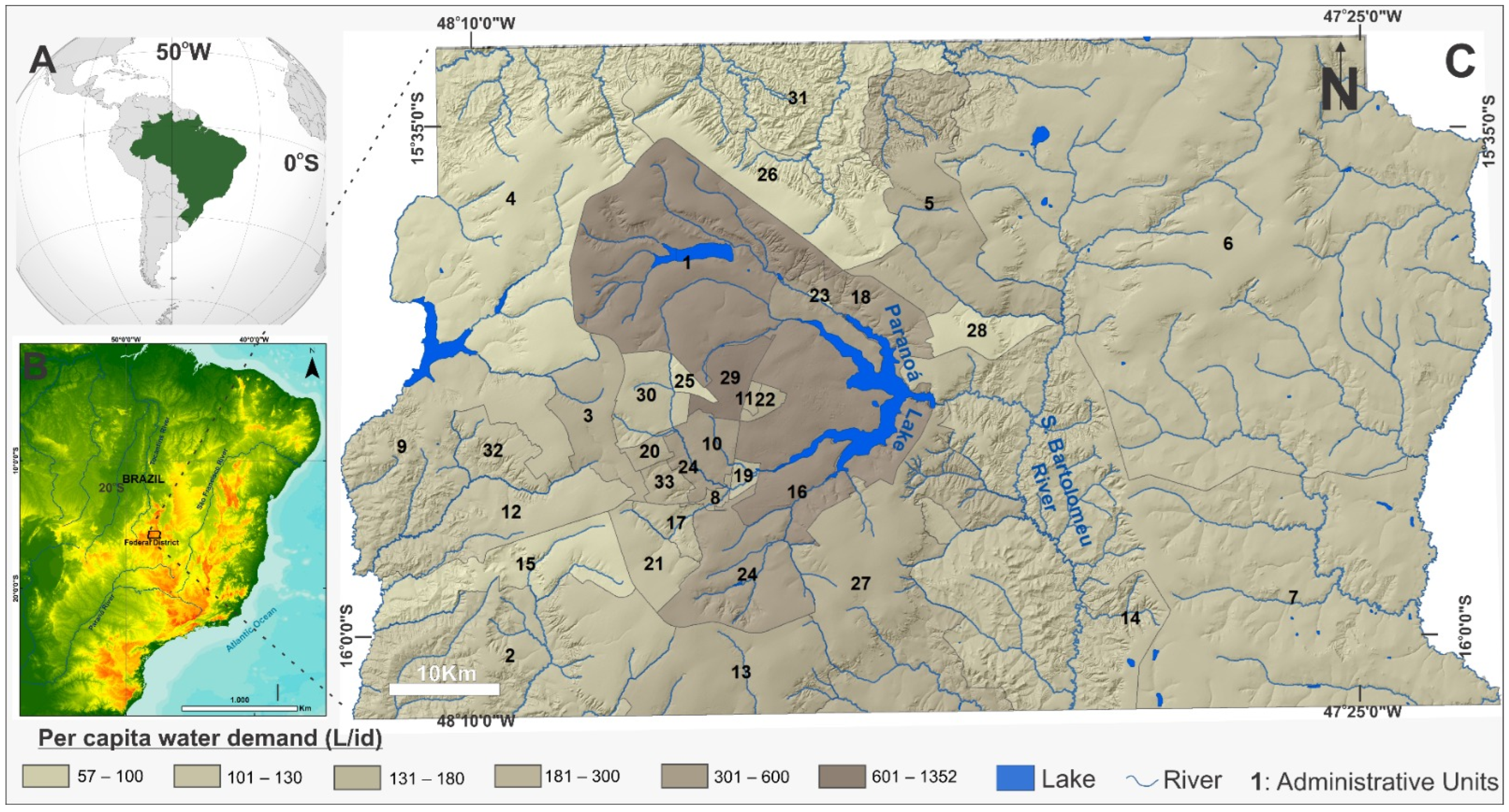
2.1. Study Area

Within the FD, the investigation was conducted in areas with the integrated supply system (Descoberto/Santa Maria—Torto system/Sobradinho Taguatinga) and in other areas located outside the integrated system (e.g., Descoberto and Santa Maria—Torto reservoirs) (Figure 1). According to the Köppen classification, the climate of the FD falls between the Tropical (Aw) and Tropical types of Altitude (Cwa and Cwb). Its striking feature is the existence of two well-established periods, defined as rainy in summer and dry in winter. The rainy period extends from October to April, while the dry period extends from May to September [17,18]. Water demand per capita varies—depending on the socioeconomic aspects of the administrative regions. In general, the demand as follows: (i) from 120 to 125 L per inhabitant and day (L/i·d) in rural areas with low human occupation density; (ii) from 126 to 140 (L/i·d): rural regions with small urban centers as headquarters of agricultural colonies; (iii) from 141 to 155 L/i·d in Planaltina and its expansion areas; (iv) from 156 to 180 L/i·d in Ceilândia; (v) from 181 to 220 L/i·d in Taguatinga and Águas Claras; (vi) from 121 to 275 L/i·d in Asas Sul and North of Brasília and (vii) from 276 to 472 L/i·d: Lago Sul de Brasília see details in Figure 1.
The geology of the FD is characterized by metamorphic rocks, covered by thick regolith. Within this geological setting, three large groups of aquifers are discriminated and classified as different groundwater domains, including the Intergranular (unconfined or porous) Domain, the Fractured Domain, and the Fissured-Karst Domain. The domains were subdivided into systems and subsystems by [17] and details can be assessed at [5]. This aquifer classification is presented in Figure 2, details are given in Table 1 and Table 2. The flow rates from pumping wells range from zero (dry wells) to more than 100 m3/h. The average flow in all aquifers (fractured and fissured-karst) is around 8000 L/h. This variability is a function of the different aquifer yielding, which depends on lithology and fracturing, soil type, and relief. In general, the more sand or quartzite content the rocks consist of, the greater is the potential of fractured and fissured-karst aquifers [17].

2.2. R3/Q3 Aquifer Sub-System

In the main water supply to the FD, some of these sub-systems have major contributions following further exploration for optimized productivity. Such aquifers are represented by the Canastra System F/Q/M sub-system and the Paranoá System R3/Q3 sub-system. The F/Q/M sub-system has intensively been used for water supply to São Sebastião, in which more than 90% comes from a battery of pumping wells located in the urban perimeter. Thus, the alternative option to supplement the water supply based on groundwater exploitation is limited to sub-system R3/Q3. This aquifer has the following characteristics that make it an attractive option for supplying urban areas: (i) it has an average flow (12,000 L/h) 0.5-fold higher than the average flow of the aquifers in the region; (ii) a low incidence of dry or very low flow rates wells; (iii) it occurs in a large area with a wide range of geographical distribution; (iv) it occupies the favorable localities suitable for the natural aquifer recharge as well as for aquifer artificial recharge projects and (v) it has good quality groundwater [3]. This aquifer sub-system has very high local relative hydrogeological importance, with a high occurrence of wells with flow rates that can be higher than 20,000 L/h. The distribution area of this sub-system is a factor that increases its local importance, occupying about 25% of the territory of the Federal District. Figure 3 presents the conceptual groundwater flow model and recharge mechanisms of the aquifer sub-systems. This is important because groundwater flow paths in the fissured/pore aquifer widely vary over several depth magnitudes. These types of circulation conditions usually occur in fault zones and in such areas vertical groundwater flow is actually more important than lateral flow [19].
The investigation was conducted on 27 different sites in the FD, which has initially been mapped with the aquifer sub-system-R3/Q3 of Brazil. The aquifer sub-system includes the Serra do Paranã (formerly Q2), Serra da Meia Noite (former R3) and Ribeirão Contagem (former Q3) of the Paranoá Group (Figure 4). The inclusion of three lithological units in a single aquifer sub-system is justified, as the types are dominantly sandy and have petrographic features that are quite similar in their hydrogeological characteristics, hydrodynamic parameters, the statistical distribution of average flow rates, and well typologies (Figure 4). The presence of quartzite makes the aquifer highly discontinuous, and it also keeps the fractures open because of the brittle behavior. In this way, the wells, that intercept rocks of different formations, would have a large number of water inlets, with fractures dispersed throughout the perforated section, in addition to significant inter-connectivity of the fractures [20].
Hydrogeological conditions widely vary over the space, thus favoring the existence of unconfined or confined conditions and very anisotropic hydrodynamic characteristics. Table 2 shows the distribution of the values of transmissivity (T), hydraulic conductivity (K), and coefficient of storage (S), calculated from the pumping tests conducted on twenty-seven pumping wells pumped for a period of 24 h. Results obtained using the Moench method in the AquiferTest software for fractured aquifers [3]. The high-water potential of this aquifer sub-system is brought by the great flow of springs. In this way, the R3/Q3 sub-system is considered the only groundwater source that still has exploitable reserves or availability of water resources capable of contributing effectively to supplement public water supply in the event of extreme scarcities.

2.3. Electrical Resistivity Tomography (ERT)

The measurement of subsurface electrical resistivity of the geological material, using different electrode arrays, has generally been adopted to identify ground layers distributions or to identify features whose dimensions and depths vary between meters up to a few kilometers. Recently, automatic systems have emerged for data collection that can speed up measurement and interpretation processes. At the same time, a greater capacity for calculations by computers has allowed, in recent years, the obtaining of images in two or three dimensions of the real distribution of resistivity of the subsurface. The electrical resistivity measuring devices commonly consist of a system of four electrodes, two of which are used to send an electric current to the ground. Wenner arrangements, polo-polo, polo-dipole, dipole-dipole, Wenner-Schlumberger, and gradients are typical electrode arrays whose selection depends on the research objective of the investigation. Each arrangement has a common characteristic such as resolution (dipole-dipole and pole-dipole), depth of investigation (pole-pole), and signal-to-noise ratio (Wenner and Wenner-Schlumberger).
For example, in groundwater prospecting applications, the dipole-dipole array is more effective among others [21]. In this array, transmitters are distanced from the receivers at a fixed distance for each investigation level, i.e., the depth and the investigated level, the distance between the transmitter and the receivers. The measurements are carried out at various levels of investigation (n), where n = 1, 2, 3, 4, 3, ... is the point of intersection between a line that starts from the center of the current electrodes and another part of the center of the potential electrodes. The result is an electrical resistivity data set obtained in n depths forming a section. This grid reflects the subsurface behavior in response to electrical currents inputs, which is a function of the mineralogical composition of the rock, pore water content, and pore-water electrical conductivity etc.

2.4. Data Acquisition and Processing

The SYSCAL System was used; it is sensitive to ambient noise during field acquisition. Two configurations prevented the high quality data acquisition itself: the presence of a wire fence barbed with concrete stakes and subsurface streetlights. In the first case, some electrodes showed very high contact resistance, and in the second, many electrodes appeared to be open. In some cases, when faced with a problem of ambient noise during acquisition, the penetration of the electrode into the soil can be increased where the volume of moisture with a saline solution would increase. However, in other cases, the problem cannot be avoided, and the section should be carried out in the most appropriate (alternative) place.
The software RES2DINV was used for the data processing workflow adopted after [5]. The data acquisition of the geophysical data was conducted along twenty-seven profiles (Figure 2); each one was approximately 350 m in length. In the field, the electrical resistivity data were collected with the electric roll-along technique, using the dipole-dipole (DD) arrangement, with a spacing of 10 m between the electrodes. The data acquisition protocol with the multi-electrode cables was elaborated in the software ELECTRE II, version 05.06.00, (IRIS Instruments) for acquisitions with 36 electrodes.
For better deployment of the geophysical prospecting, the field activities were carried out during the dry season and moisture in the soil was increased by pouring salt solution at each electrode, thus helping to minimize the absorption of electric current in the soil. The data were acquired with SYSCAL Pro 72 equipment (manufactured by IRIS Instruments), consisting of an interleaved acquisition module in multi-electrode cables. Thirty-six stainless steel electrodes were used to inject current and measure the electric potential generated by the current flow in the subsurface. ERT data were processed in a similar approach adopted by [22]. The filtering and topographical correction on the dataset were performed in the PROSYS II software (IRIS Instruments). In order to determine the effective depth, the pseudo-sections of electrical resistivity were inverted using the computer program RES2DINV (Geotomo Software). In our case, the resistivity values near the ground are high; therefore, narrower model cells were used in the RES2DINV program, where the width of model blocks was kept half of the electrode spacing for optimum result. The 2D model was then developed, which divides the subsurface into a series of blocks to determine the resistivity; its product is apparent resistivity pseudo-sections that fit with the field data, using an inversion process based on the variation of the least square method. The results obtained were presented in the form of 2D resistivity sections. The DC resistivity data processing workflow is shown in Figure 5.

3. Results and Discussion

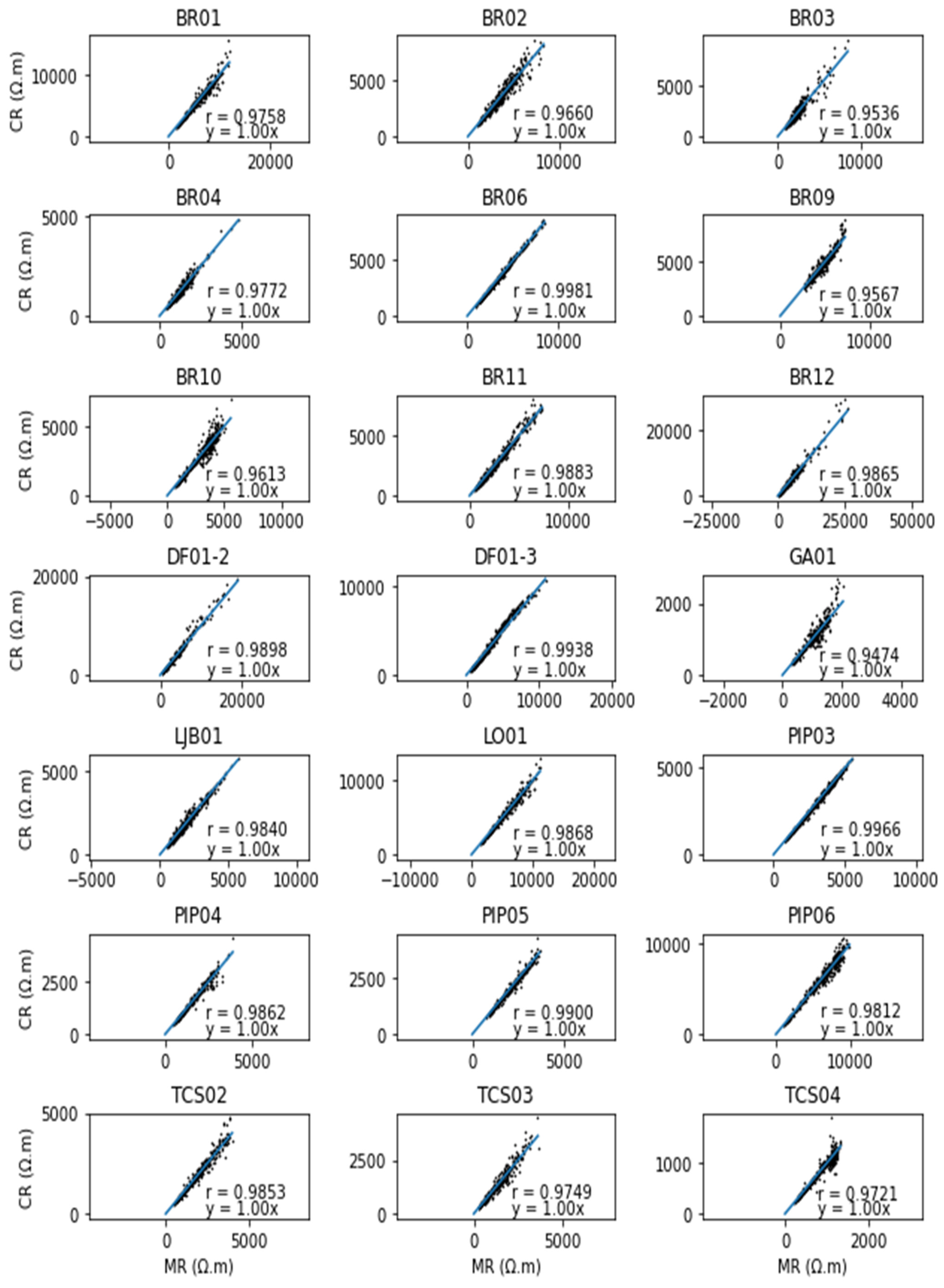
3.1. Analysis of ERT Data and Overview of the Findings

In the first stage of ERT data processing, the apparent and calculated resistivity along twenty-two profiles were analyzed. Linear regression is developed and the correction coefficient is calculated. In Figure 6 it can be seen that all the profiles show a value of ‘r’ greater than 0.9, which is acceptable accuracy. For some of the profiles, odd data points were trimmed to achieve this level of accuracy. However, five of the acquired profiles showed r-value < 0.9 and therefore these were removed from the analysis.
Following this initial stage, inverted ERT anomalies were correlated to the hydrogeological features inferred from the available information of the groundwater flow system R3/Q3. Then, the hydrogeological meaning of each feature with the groundwater development was highlighted. The correlation of inverted resistivity values with the lithological log of the nearby pumping wells reveals a three-layered subsurface stratigraphy as dry topsoil, saprolite, and quartzite (Q3) and at some places, Meta-rithmite clayey and sandy (R3) formations are also found. Along with layered stratigraphy, the numerous features of hydrogeological significance have been delineated on some of the inverted cross-sections as resistivity anomalies. These structures are recommended for future detailed investigations that may include the application of integrated geophysical techniques followed by geotechnical investigations and then finally the installation of pumping wells at the site. These features have been documented in numerous previous studies [8,10,23,24,25,26,27,28,29,30]. A common contour interval and respective color scale are chosen for all the resistivity inversion models. A detailed description of these features is provided below.

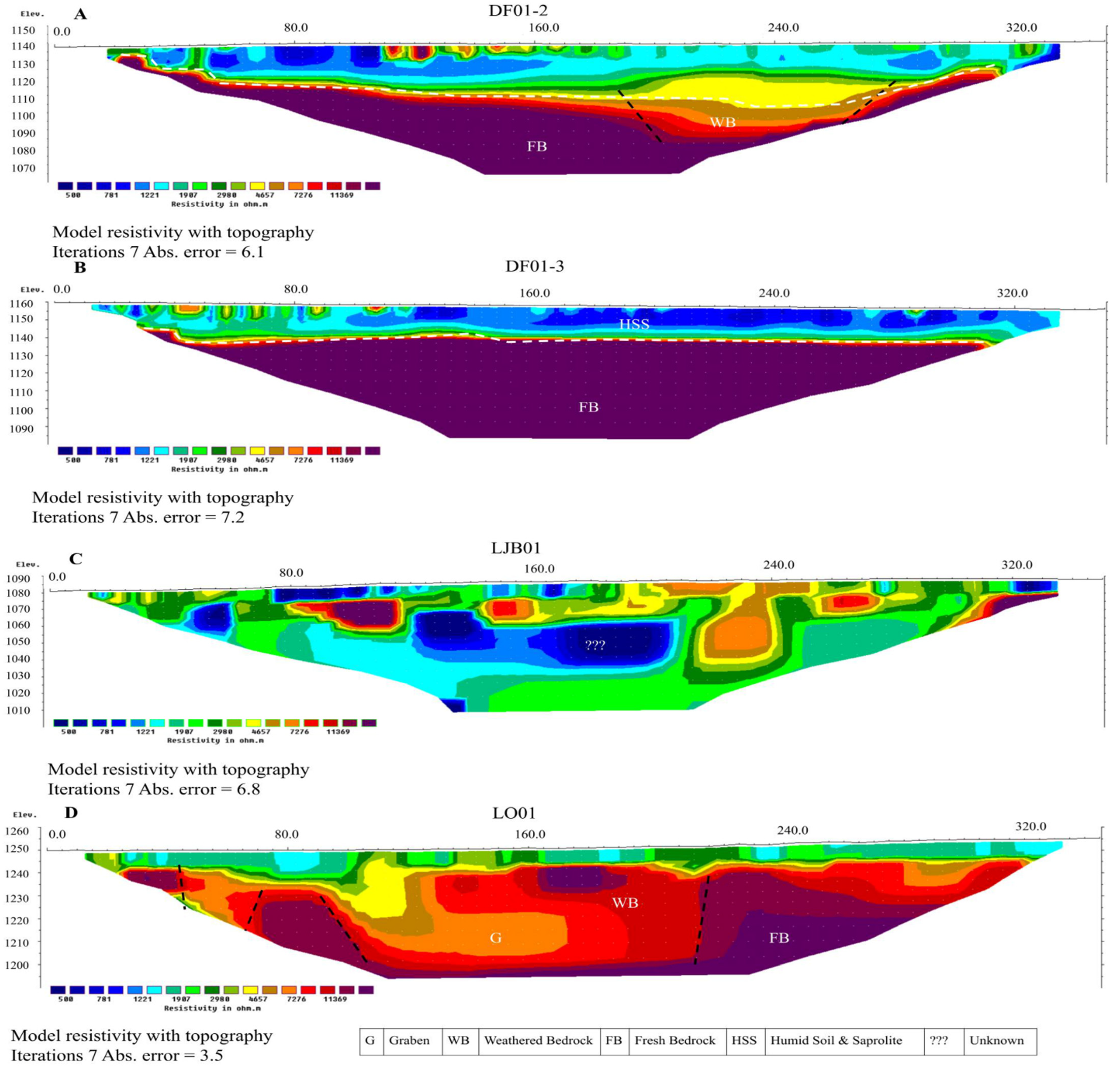
3.2. Resistivity Inversion Models and Geological Features

In the hard rock aquifers (plutonic and metamorphic), the groundwater development (presence and movement) is related to the secondary permeability in the rock matrix, created by weathering of the fresh bedrock. The tectonics of the region has nothing to do with the creation of this permeability [31]. These weathered portions of the bedrock can be detected on the inverted resistivity cross-section as a relatively low resistivity anomaly compared with the underlying fresh bedrock. Almost all ERT profiles mark the presence of this weathered profile with different thickness, degrees of weathering, and moisture contents (Figure 7, Figure 8, Figure 9, Figure 10, Figure 11 and Figure 12). These sections are considered important features for groundwater development.
At the centers of the 2D profiles, as seen in Figure 8A–D, sharp contrasting anomalies may suggest structural features separating very high resistivity of the order of ≥7000 Ω m and low resistivity <7000 Ω m conducting zone from bottom depth ~10 m till close to the surface. It marks the position of the fault, high resistive material, and the recharge’s pathway. It is interesting to note that on profiles shown in Figure 7A–D, increasing trends in the resistivity of the bedrock are observed. This may be associated with the rock breaking by fissuring and lineaments. Therefore, the center of this bedrock might have become boulders as described by [28]. This indicates highly weathered moisture saturated and quartzite of sub-system R3/Q3.
Fault mapping is key to understanding groundwater flow in hard-rock aquifers [32,33,34]. It is worth noting that faults can be seen in Figure 7A–D, Figure 8B,D, Figure 9A,D and Figure 10B,D. On ERT profiles, the faults are identified as sharp vertical boundaries found between two layers with distinct differences in resistivities. On some of the profiles (BR02, BR03, BR04), the strata above bedrock show resistivity ranging from <10 to >1000 Ω m as seen in Figure 7B–D. The prominent graben-like structures can be seen on some resistivity profiles, which were created by the faults (Figure 7A, Figure 8B and Figure 9D) in quartzite hard-rock. These structures have also been reported in previous studies on Brazilian aquifer systems [2,33,34]. A similar approach for delineation of faults has been adopted by [8].
The fractured zone’s shape and position in quartzite are delineated based on resistivity contrast on the 2D resistivity models as shown in Figure 7B and Figure 8A,D. At the top, the fractured zones show variations in resistivity values related to the degree of weathering and thus are hydrologically potential sites for groundwater development in the areas. The comparatively low resistivity range (2000 to >10,000 Ω m) of ridge-like structures might be related to the coarse-grained material composition and having high permeability can favor rainfall infiltration and may act as aquifer recharge zones.
The depth and topography are important features for groundwater flow. In dual-porosity rocks, the base flow occurs primarily in fractures, while intergrain porosity plays an important role in water storage. The circulation of water in dual-porosity rocks is often very complex and is the subject of controversy in Groundwater Hydrology. This applies in particular to hydrogeochemistry and tracer study due to the possible diffusion exchange between the water flowing in the crevices and the stagnant water contained in the micropores of the rock matrix. More about the circulation of groundwater in double (or triple) porosity systems can be found, among others, in the previous works [33,34]. In comparison with the geological sequence of the studied area (comprising topsoil, saprolite and quartzite—Figure 4), the 2D resistivity cross-sections show the three-layered stratigraphy as well as the presence of soil contents in the strata as low resistivity anomalies (Figure 11B). The model shows the bedrock at shallow depth (20 m) and 350 m lateral distance along the profile. This information aids groundwater exploration in the area. With the available geological information, it is difficult to separate the geology of bedrock whether it is a quartzite of Q3 unit or sandy or clayey Metarrithmite of R3. However, onsite field investigations and communications with the experts working on the area are the sole criteria for the attribution of these rock units. Another important aspect of the bedrock topographic variation is the development of compartmentalized aquifers and its effect on groundwater yielding. In this study, the formation of graben-like structures may indicate this compartmentalization (Figure 7).
The secondary porosity created by the network of joints, fault planes, and bedding planes may form the aquifer system in the area in quartzite rocks [5]. This system may be identified on the inverted resistivity sections, where a relatively low resistivity zone (<100 Ω m) exists (Figure 9B, Figure 10A,B and Figure 11B,D). These deeper low resistivity anomalies may present a potential site for groundwater development. Along with sufficient recharge, the exploitation of the groundwater from these deeper levels is important for the sustainability of the aquifer. Another possible explanation of this low resistivity deep anomaly would be the presence of a high clay proportion, which is created by the weathering of bedrock as explained above. Another possibility is the presence of sandy and clayey rocks of the R3 sub-system. However, in the present study, it is difficult to make this segregation because of the unavailability of the required information.

4. Discussion

The results presented above generally agree with previous studies, which were carried out in different regions of Brazil, focusing on various groundwater regimes that highlight the role of litho-stratigraphy and hydrogeological features on the aquifer systems, which includes their geometries as well as hydrogeological characteristics [11,12,13,14,15,16,17]. The effects of porosity, permeability, and faults (acting as a barrier slowing water flow or connectors between aquifers) on the transmissivity are evaluated [35]. In addition to the role of faults causing structural aquifer compartmentalization, they may affect the volume of the aquifer by reducing or increasing its thickness as documented by [4,14]. Similarly, the significance of these hydrogeological features delineated on inverted resistivity cross-sections from an aquifer system of Brasilia is highlighted.
The geophysical results in Figure 7, Figure 8, Figure 9, Figure 10, Figure 11 and Figure 12 shows overlapping layers (soil and rock), variations in soil and saprolite thickness, and a vertical anomaly position. Most of the profiles were taken in areas along the lineament, where significant geoelectric anomalies were found. The complexity of the hard rock aquifer is evident from the structural and spatial variability of its fracture networks and weathering [36]. The following are the detailed discussions on groundwater exploration features marked on the inverted resistivity sections.
The weathering processes have changed the properties of the bedrock, increasing the porosity and secondary permeability leading to the development of fractures. The fluid circulation is supported by the fractures prior to weathering. Another aspect is the precipitation, which may affect the structures of interest either positively or negatively [37]. The weathered profile is present on all profiles, which indicates the degree of weathering in the metamorphic basement aquifer. Along with groundwater development, the depth of weathered rocks has a prominent effect on many earth surface processes such as routing water and nutrients. The bedrock stored water can be used by plants in case of drought conditions through their roots penetration. The bedrock drainage can also influence the area’s stream flows, their water quality, and also maintain base flow, especially in dry seasons. In this way, a direct nexus between the surface-groundwater can be seen. This connection is very important in any groundwater vulnerability assessment study. Another important influence is based on the extent of alteration in landscape evolution through the development of pore-water pressure related to the water circulation, which is an important trigger for shallow clayey landslides in the Federal District as documented by [5]. These aspects of weathering the bedrock are explained in detail by [38]. The presence of faults/discontinuities at the base of the weathering profile can also affect the hydraulic conductivity and have a major influence on the groundwater flow systems by affecting their hydraulic conductivity [36]. These fractures and fissures can also be developed by the expansion of minerals during the weathering process [39]. Depending on their form and material properties, these can be considered groundwater flow channels as conduits, barriers, or a combined conduit-barrier system and storage sites. The hydraulic fault behavior to transverse flow changed in case of acting as a barrier in the presence of clay-like materials (alteration of primary minerals) accumulation into fault cores. In contrast, the weathered or damaged zones improved the hydrodynamic properties of the aquifer rather than the fresh bedrocks, and they can also concentrate the water and improve its channelization along faults and fissures and improve discharge at the well [37,40]. On the one side, such a fault can provide a good source of groundwater where the source is connected to a deeper conducting zone with appreciable resistivity in contrast with the surrounding quartzite rock. On the other side, the fault can also act as a groundwater flow barrier as explained by [41]. The delineated graben-like structures created by faulting may be associated with the reservoir compartmentalization (fluid/pressure compartments created by sealed boundaries) as described by [2]. Therefore, these hydrogeological features are the potential site for groundwater development. These heterogeneous hydrogeological settings can also (i) influence the nitrate contamination transport and its fate by biogeochemical mechanisms [26], and (ii) increase the vulnerability of aquifers from surficial contaminates. These structures may outcrop at the ground and provide a pathway for contaminant transport. Therefore, the potential sites for groundwater can also increase the vulnerability of the underlying aquifer.
In the case of the existence of prominent geological discontinuities and fracture networks, the groundwater flow leads to the compartmentalization of the aquifer system. This geologic compartmentalization is further enhanced by the hydraulic containment created by the well’s pumping. The hydrological models created from ERT inversion results show the three geological layers: the saprolite, which is mostly unsaturated during the dry season, the fissured layer, which provides most of the flow to the pumping wells, and the fresh bedrock. In the case of the depletion of the water table in the dry season created by intense pumping, the geological discontinuities may act as a barrier to flow and divide the aquifer into different compartments. As a result, the discharge at the nearby well decreases. It also causes variable groundwater chemistry [37].
In short, the delineated features can affect the hydrodynamics of the FD aquifer in various ways. The presence of quartzite bedrock topography and degree of weathering can affect the hydrodynamic characteristics of the site. One important feature is the brittle nature of the quartzite, which leads to opening of the fractures and thus creates a conducive environment for groundwater development. The open fractures can provide pathways for the aquifer recharge as well as increase the production of the installed wells. The presence of quartzite rocks is another peculiar hydrological feature of the FD aquifers and are delineated on ERT profiles. The presence of a thick soil layer and vegetation can hold the rainfall water, providing a conducive condition for the aquifer recharge. Almost all ERT profiles have a top-soil layer, however, its thickness and resistivity range significantly vary in the investigated areas. Like topsoil, the thick saprolite can also be seen on all profiles. This layer has quite variable resistivity values—mainly related to the degree of saturation or presence of high clayey proportions. On some of the profiles, the saprolite (high porosity, low permeability) layer is found to be very thick, which means it can store large volumes of groundwater and allows pumping the water from the underlain weathered zone (high permeability), which will significantly enhance the pumping life of the well. This thicker profile layer is also documented in a study conducted on nearby areas by [5]. Along with the role in groundwater prospecting, these structures of interest have a connection with the landslide hazards of the areas. The extremely heterogeneous geological conditions (with layers of various permeability) lead to the exfiltration of water stored temporarily in the clayey formation, which may create perched aquifer conditions. Because of this permeability contrast, excessive pore-water pressure may develop, leading to slope instability in the region [22].
Based on the discussion above, the present study was able to highlight how key hydrologic processes are affected by the subsurface structures delineated on ERT cross-sections (e.g., depth to bedrock, weathered bedrock, and the topography of bedrock). As this field-work is based in a tropical Brazilian aquifer, the outcomes will inform current water resource management efforts accomplished by the local and regional authorities.

5. Conclusions and Recommendations

The main goal of the study is to investigate the hydrogeological characteristics of the aquifer sub-system-R3/Q3 of the Federal District of Brazil to improve groundwater extraction and pumping-well planning with the aid of ERT geophysical method. The study delineates the key hydrological drivers that modulate subsurface water storage and regulate groundwater development in the subsurface, which influences the hydrology in many ways. These include saprolite, fractured and fresh bedrocks, and their depths and topographies. On the inverted resistivity tomographs, site stratigraphy and other numerous structures are delineated, which have a direct influence on the hydrodynamics of the aquifer.
This study is significant because it provides a description of the aquifer sub-system of the area based on ERT profiles. The approach provides a promising framework for investigating and extracting groundwater in regions underlain by quartzite hard rock aquifers. Overall, the study strengthens the idea that geophysical methods can aid groundwater exploration in challenging geological settings. Therefore, this approach is recommended to be carried out on similar quartzite aquifers, which would ensure that the use of ERT inverted resistivity profiles accompanied with the geological information optimizes both position and productions of pumping wells. As this field-work is based in a tropical Brazilian aquifer, the outcomes will inform current water resource management efforts accomplished by the local and regional authorities.
In addition to groundwater prospecting, the use of ERT method also allowed us to identify geological structures and permeability contrast in connection with the landslide hazards of the area, which presents a further strength of our approach. For future work, coupled numerical modelling informed by geophysical, geological, hydrological, and meteorological data should be considered for a more accurate estimation of wells’ production combined with landslide stability assessment.

Author Contributions

Conceptualization, Y.H. and J.E.G.C.; methodology, Y.H. and J.E.G.C.; software, W.R.B., Y.H. and R.E.S.U.; validation; (field) investigation, J.E.G.C.; writing—original draft preparation, Y.H.; writing—review Y.H. and O.H.; editing, O.H. and H.-B.H. All authors have read and agreed to the published version of the manuscript.

Funding

This research received no external funding.

Institutional Review Board Statement

Not applicable.

Informed Consent Statement

Not applicable.

Data Availability Statement

Data are available on request to the corresponding author.

Acknowledgments

The authors are most grateful to the University of Brasilia-UnB and Regulatory Agency for Water, Energy, and Basic Sanitation of the Federal District of Brazil (ADASA) for providing the resistivity data and other related information. The authors would like to thank the two anonymous reviewers and the editor for their constructive comments, which helped us to improve the manuscript.

Conflicts of Interest

The authors declare no conflict of interest.

References

  1. Lorz, C.; Abbt-Braun, G.; Bakker, F.; Borges, P.; Börnick, H.; Fortes, L.; Frimmel, F.H.; Gaffron, A.; Hebben, N.; Höfer, R.; et al. Challenges of an integrated water resource management for the Distrito Federal, Western Central Brazil: Climate, land-use and water resources. Environ. Earth Sci. 2012, 65, 1575–1586. [Google Scholar] [CrossRef]
  2. Nunes, L.M.G.; Lucena, L.R.F.D.; Silva, C.C.N.D. Reserve evaluation of a fault-conditioned aquifer: The Barreiras Aquifer in the coastal region of NE Brazil. Braz. J. Geol. 2020, 50. Available online: https://www.scielo.br/j/bjgeo/a/yyrTjbQSg3W5qkcMzqHfqQC/?lang=en (accessed on 19 September 2021). [CrossRef]
  3. ADASA, Avaliação de aquíferos favoráveis para complementação ementação do abastecimento de água no distrito federal e locação de poços tubulares profundos: Profundos regiões atendidas e não atendidas pelo sistema integrado descoberto de—Santa Maria/torto. 2017. Available online: https://www.adasa.df.gov.br/ (accessed on 1 May 2021).
  4. Kuznetsov, M.; Viero, A.P.; Sorek, S.; Roisenberg, A.; Ronen, D. Modeling the Flow Pattern at the Fractured Granites in Porto Alegre, Brazil. Transp. Porous Media 2014, 101, 413–436. [Google Scholar] [CrossRef]
  5. Hussain, Y.; Uagoda, R.; Borges, W.; Susanne, M.; Hamza, O.; Havenith, H.-B. Estimation of total groundwater reserves and delineation of weathered/fault zones for aquifer potential: A case study of Federal District—Brazil. Open Geosci. 2021, 13, 1–13. [Google Scholar] [CrossRef]
  6. Comte, J.-C.; Cassidy, R.; Nitsche, J.; Ofterdinger, U.; Pilatova, K.; Flynn, R. The typology of Irish hard-rock aquifers based on an integrated hydrogeological and geophysical approach. Hydrogeol. J. 2012, 20, 1569–1588. [Google Scholar] [CrossRef]
  7. Zhou, Q.Y.; Matsui, H.; Shimada, J. Characterization of the unsaturated zone around a cavity in fractured rocks using electrical resistivity tomography. J. Hydraul. Res. 2004, 42, 25–31. [Google Scholar] [CrossRef]
  8. Kumar, D.; Rao, V.A.; Sarma, V.S. Hydrogeological and geophysical study for deeper groundwater resource in quartzitic hard rock ridge region from 2D resistivity data. J. Earth Syst. Sci. 2014, 123, 531–543. [Google Scholar] [CrossRef]
  9. Junaid, M.; Abdullah, R.A.; Saa’Ri, R.; Alel, M.; Ali, W.; Ullah, A. Recognition of boulder in granite deposit using integrated borehole and 2D electrical resistivity imaging for effective mine planning and development. Bull. Geol. Soc. Malays. 2019, 67, 99–104. [Google Scholar] [CrossRef]
  10. Briški, M.; Stroj, A.; Kosović, I.; Borović, S. Characterization of Aquifers in Metamorphic Rocks by Combined Use of Electrical Resistivity Tomography and Monitoring of Spring Hydrodynamics. Geosciences 2020, 10, 137. [Google Scholar] [CrossRef] [Green Version]
  11. De Lucena, L.R.F.; de Rosa Filho, E.F.; Hindi, E.C. O CONTROLE ESTRUTURAL NO AQÜÍFERO BARREIRAS—ÁREA DA BACIA DO RIO PIRANGI (RN). Águas Subterrâneas 2006, 20, 83–98. [Google Scholar] [CrossRef] [Green Version]
  12. Soares, A.P.; Soares, P.C.; Bettú, D.F.; Holtz, M. VARIABILIDADE ESPACIAL NO SISTEMA AQÜÍFERO GUARANI: CONTROLES ESTRUTURAIS E ESTRATIGRÁFICOS. Águas Subterrâneas 2007, 21. [Google Scholar] [CrossRef] [Green Version]
  13. Rodrigues, M.A.C.; Lucena, L.R.F.; Souza, I.V.F. Preliminary geometric model of the Barreiras Aquifer derived from hydrogeophysics data at the River Catu basin, NE Brazil. In Proceedings of the 12th International Congress of the Brazilian Geophysical Society, Rio de Janeiro, Brazil, 15–18 August 2011. [Google Scholar]
  14. Lucena, L.R.F.; Oliveira, J.G., Jr.; Medeiros, W.E.; Queiroz, M.A. The potential of the Barreiras Aquifer in the lower course of the Doce River, Rio Grande do Norte State, Northeast Brazil—Integration of hydrogeologica land geophysical data. Braz. J. Geophys. 2013, 31, 43–57. [Google Scholar] [CrossRef] [Green Version]
  15. Burazer, M.; Žitko, V.; Radaković, D.; Parezanović, M. Using geophysical methods to define the attitude and extension of water-bearing strata in the Miocene sediments of the Pannonian Basin. J. Appl. Geophys. 2010, 72, 242–253. [Google Scholar] [CrossRef]
  16. Díaz, D.; Maksymowicz, A.; Vargas, G.; Vera, E.; Contreras-Reyes, E.; Rebolledo, S. Exploring the shallow structure of the San Ramón thrust fault in Santiago, Chile (~33.5° S), using active seismic and electric methods. Solid Earth 2014, 5, 837–849. [Google Scholar] [CrossRef] [Green Version]
  17. Zoby, J.L.; Duarte, U. Caracterização hidrogeológica da bacia do Ribeirão Sobradinho-Brasília (DF). Geologia USP Série Científica 2001, 1, 79–99. [Google Scholar] [CrossRef]
  18. Campos, J.E.G. Hidrogeologia do Distrito Federal: Bases para a gestão dos recursos hídricos subterrâneos. Braz. J. Geol. 2004, 34, 41–48. [Google Scholar] [CrossRef]
  19. Kotowski, T.; Chudzik, L.; Najman, J. Application of dissolved gases concentration measurements, hydrochemical and isotopic data to determine the circulation conditions and age of groundwater in the Central Sudetes Mts. J. Hydrol. 2019, 569, 735–752. [Google Scholar] [CrossRef]
  20. Campos, J.E.G.; Bogossian, J.; Carvalho, R.M. Sedimentology of the Psammo-pelitic-carbonate Unit, Paranoá Group, and Sete Lagoas Formation, Bambuí Group: Examples of mixed carbonate-siliciclastic sedimentation in the Proterozoic of the Brasília Fold Belt. Rev. Bras. Geociências 2012, 42, 513–522. [Google Scholar] [CrossRef] [Green Version]
  21. Gallas, J.D.F.; Taioli, F.; Filho, W.M. Induced polarization, resistivity, and self-potential: A case history of contamination evaluation due to landfill leakage. Environ. Earth Sci. 2011, 63, 251–261. [Google Scholar] [CrossRef]
  22. Hussain, Y.; Cardenas-Soto, M.; Martino, S.; Moreira, C.; Borges, W.; Hamza, O.; Prado, R.; Uagoda, R.; Rodríguez-Rebolledo, J.; Silva, R.C.; et al. Multiple Geophysical Techniques for Investigation and Monitoring of Sobradinho Landslide, Brazil. Sustainability 2019, 11, 6672. [Google Scholar] [CrossRef] [Green Version]
  23. Comte, J.-C.; Ofterdinger, U.; Legchenko, A.; Caulfield, J.; Cassidy, R.; González, J.A.M. Catchment-scale heterogeneity of flow and storage properties in a weathered/fractured hard rock aquifer from resistivity and magnetic resonance surveys: Implications for groundwater flow paths and the distribution of residence times. Geol. Soc. London Spec. Publ. 2019, 479, 35–58. [Google Scholar] [CrossRef] [Green Version]
  24. Cassidy, R.; Comte, J.-C.; Nitsche, J.; Wilson, C.; Flynn, R.; Ofterdinger, U. Combining multi-scale geophysical techniques for robust hydro-structural characterisation in catchments underlain by hard rock in post-glacial regions. J. Hydrol. 2014, 517, 715–731. [Google Scholar] [CrossRef]
  25. Donohue, S.; McCarthy, V.; Rafferty, P.; Orr, A.; Flynn, R. Geophysical and hydrogeological characterisation of the impacts of on-site wastewater treatment discharge to groundwater in a poorly productive bedrock aquifer. Sci. Total. Environ. 2015, 523, 109–119. [Google Scholar] [CrossRef] [PubMed] [Green Version]
  26. Orr, A.; Nitsche, J.; Archbold, M.; Deakin, J.; Ofterdinger, U.; Flynn, R. The influence of bedrock hydrogeology on catchment-scale nitrate fate and transport in fractured aquifers. Sci. Total. Environ. 2016, 569–570, 1040–1052. [Google Scholar] [CrossRef] [Green Version]
  27. Alle, I.C.; Descloitres, M.; Vouillamoz, J.-M.; Yalo, N.; Lawson, F.M.A.; Adihou, A.C. Why 1D electrical resistivity techniques can result in inaccurate siting of boreholes in hard rock aquifers and why electrical resistivity tomography must be preferred: The example of Benin, West Africa. J. Afr. Earth Sci. 2018, 139, 341–353. [Google Scholar] [CrossRef]
  28. Noorellimia, M.T.; Aimrun, W.; Azwan, M.M.Z.; Abdullah, A.F. Geoelectrical parameters for the estimation of hydrogeological properties. Arab. J. Geosci. 2019, 12, 62. [Google Scholar] [CrossRef]
  29. Lee, S.C.H.; Noh, K.A.M.; Zakariah, M.N.A. High-resolution electrical resistivity tomography and seismic refraction for groundwater exploration in fracture hard rocks: A case study in Kanthan, Perak, Malaysia. J. Asian Earth Sci. 2021, 218, 104880. [Google Scholar] [CrossRef]
  30. Pires, C.A.; Athayde, G.B.; de Souza Filho, O.A.; Ofterdinger, U. Litho-structural conditioning in the exploration of fractured aquifers: A case study in the Crystalline Basement Aquifer System of Brazil. Hydrogeol. J. 2021, 29, 1657–1678. [Google Scholar] [CrossRef]
  31. Lachassagne, P.; Wyns, R.; Dewandel, B. The fracture permeability of Hard Rock Aquifers is due neither to tectonics, nor to unloading, but to weathering processes. Terra Nova 2011, 23, 145–161. [Google Scholar] [CrossRef]
  32. Kumar, D. Efficacy of electrical resistivity tomography technique in mapping shallow subsurface anomaly. J. Geol. Soc. India 2012, 80, 304–307. [Google Scholar] [CrossRef]
  33. Zuber, A.; Motyka, J. Hydraulic parameters and solute velocities in triple-porosity karstic-fissured-porous carbonate aquifers: Case studies in southern Poland. Environ. Geol. 1998, 34, 243–250. [Google Scholar] [CrossRef]
  34. Motyka, J. A conceptual model of hydraulic networks in carbonate rocks, illustrated by examples from Poland. Hydrogeol. J. 1998, 6, 469–482. [Google Scholar] [CrossRef]
  35. Pilli, A.; Sapigni, M.; Zuppi, G.M. Karstic and alluvial aquifers: Conceptual model for the plain—Prealps system (northeastern Italy). J. of Hydrolo. 2012, 464–465, 94–106. [Google Scholar] [CrossRef]
  36. Adabanija, M.A.; Kolawole, L.L.; Afolabi, A.O.; Osinowo, O.O. Investigating aquifer structure in a low-latitude crystalline basement complex of southwestern Nigeria using radial vertical electrical sounding. Arab. J. Geosci. 2021, 14, 1–14. [Google Scholar] [CrossRef]
  37. Perrin, J.; Ahmed, S.; Hunkeler, D. The effects of geological heterogeneities and piezometric fluctuations on groundwater flow and chemistry in a hard-rock aquifer, southern India. Hydrogeol. J. 2011, 19, 1189–1201. [Google Scholar] [CrossRef]
  38. Pedrazas, M.A.; Hahm, W.J.; Dralle, D.; Nelson, M.D.; Breunig, R.E.; Fauria, K.E.; Bryk, A.B.; Dietrich, W.E.; Rempe, D.M. The relationship between topography, bedrock weathering, and water storage across a sequence of ridges and valleys. J. Geophys. Res. Earth Surf. 2021, 126, 217. [Google Scholar] [CrossRef]
  39. Kouamé, I.K.; Douagui, A.G.; Bouatrin, D.K.; Kouadio, S.K.A.; Savané, I. Assessing the hydrodynamic properties of the fissured layer of granitoid aquifers in the Tchologo Region (Northern Côte d’Ivoire). Heliyon 2021, 7, 07620. [Google Scholar] [CrossRef]
  40. Place, J.; Géraud, Y.; Diraison, M.; Herquel, G.; Edel, J.B.; Bano, M.; Le Garzic, E.; Walter, B. Structural control of weathering processes within exhumed granitoids: Compartmentalisation of geophysical properties by faults and fractures. J. Struct. Geol. 2016, 84, 102–119. [Google Scholar] [CrossRef]
  41. Figueroa, R.; Viguier, B.; Taucare, M.; Yáñez, G.; Arancibia, G.; Sanhueza, J.; Daniele, L. Deciphering groundwater flow-paths in fault-controlled semiarid mountain front zones (Central Chile). Sci. Total. Environ. 2021, 771, 145456. [Google Scholar] [CrossRef]
Figure 1. (A) Location of Brazil on South American map, (B) Location of Federal District (FD) on map of Brazil and (C) Administrative units of FD based on per capita water demand (source: [3]).
Applsci 12 02509 g001
Figure 2. Geological units catalogued in Brasilia.
Applsci 12 02509 g002
Figure 3. Conceptual groundwater flow model (A) recharge mechanism (B) of the aquifer sub-systems (A, R3, Q3, R4, F) of Brasilia.
Applsci 12 02509 g003
Figure 4. Synthesized lithological log of the area and photographs of the rock outcrops in the fractured aquifer system of Brasilia.
Applsci 12 02509 g004
Figure 5. Processing workflow of DC resistivity data.
Applsci 12 02509 g005
Figure 6. The relationship between calculated and measured resistivity at twenty-two ERT profiles. The abbreviations CR and MR stand for calculated and measured resistivities, respectively.
Applsci 12 02509 g006
Figure 7. 2D resistivity models (AD) in the region of Brasilia using a dipole-dipole array.
Applsci 12 02509 g007
Figure 8. 2D resistivity models (AD) in the region of Brasilia using the dipole-dipole array.
Applsci 12 02509 g008
Figure 9. 2D resistivity models (AD) in the region of Brasilia using the dipole-dipole array.
Applsci 12 02509 g009
Figure 10. 2D resistivity models (AD) in the region of Brasilia using the dipole-dipole array.
Applsci 12 02509 g010
Figure 11. 2D resistivity models (AD) in the region of Brasilia using the dipole-dipole array.
Applsci 12 02509 g011
Figure 12. 2D resistivity models in the region of Brasilia using the dipole-dipole array.
Applsci 12 02509 g012
Table 1. Classification of the Federal District aquifers based on flow rates, lithology, and soil type [18].
DomainSystemSub-SystemFlow Rate (m3/h)Lithology/Soil Type
UnconfinedSystem P1 <0.8Sandy latosols and Quartzarenic Neosols
System P2 <0.5Clayey oxisols
System P3 Plinthic and argillaceous
System P4 <0.3Cambisol and Litholic Neosol
FracturedParanoaS/A12.5Metasiltite
A4.5Slates
R3/Q312.0Sandy quartzites and metarhythmites
R46.5Clayey meta-rhythmites
CanastraF7.5Micaceous phyllites
BambuiTopo6.0Silitos and Arcoses
Araxa-3.5Mica shales
Fissured-KarsticParanoaPPC9.0Metasiltites and marble lenses
CanastraF/Q/M33.0Calciphyllites, quartzite and marbles
BumbuiBase9.0Silite and micritic limestone lenses
Table 2. Hydrogeological characteristics of the R3/Q3 aquifer sub-system. 24-h pumping test data of 27 deep pumping wells.
UnitsR3Q3
MaximumMinimumAverageMaximumMinimumAverage
T(m2/s)7.8 × 10−41.2 × 10−44.9 × 10−41.4 × 10−31.4 × 10−44.0 × 10−4
K(m/s)4.8 × 10−65.3 × 10−72.8 × 10−61.6 × 10−31.2 × 10−64.6 × 10−6
S1.7 × 10−12 × 10−21.0 × 10−11.6 × 10−14.5 × 10−31.5 × 10⁻¹
Q(m3/h)480.012.5420.012.4
Publisher’s Note: MDPI stays neutral with regard to jurisdictional claims in published maps and institutional affiliations.

