Article

The Unique Granite Gorge in Mountainous Adygeya, Russia: Evidence of Big and Complex Geosite Disproportions

by
Anna V. Mikhailenko
1,
Dmitry A. Ruban
2,*,
Natalia N. Yashalova
3 and
Maksim B. Rebezov
2,4,5,6
1
Department of Physical Geography, Ecology, and Nature Protection, Institute of Earth Sciences, Southern Federal University, Zorge Street 40, Rostov-on-Don 344090, Russia
2
K.G. Razumovsky Moscow State University of Technologies and Management (the First Cossack University), Zemlyanoy Val 73, Moscow 109004, Russia
3
Department of Economics and Management, Business School, Cherepovets State University, Sovetskiy Avenue 10, Cherepovets, Vologda Region 162600, Russia
4
South Ural State University, Lenin Avenue 76, Chelyabinsk 454080, Russia
5
Ural State Agrarian University, Karl Liebknecht Street 42, Yekaterinburg 620075, Russia
6
V.M. Gorbatov Federal Research Center for Food Systems of Russian Academy of Sciences, Talalikhin Street 26, Moscow 109316, Russia
*
Author to whom correspondence should be addressed.
Geosciences 2019, 9(9), 372; https://doi.org/10.3390/geosciences9090372
Submission received: 20 July 2019 / Revised: 24 August 2019 / Accepted: 26 August 2019 / Published: 27 August 2019

Abstract

:
Geological heritage sites (geosites) are subject to conservation and exploitation for science, education, and tourism. Some geosites are big and comprise diverse phenomena. Concentration of the latter in some parts of these geosites makes them disproportionate. A typical example is the Granite Gorge in SW Russia that is of recognizable tourism importance. It stretches for ~5 km and represents a deep valley of the Belaya River and Late Paleozoic granitoids of the Dakh Crystalline Massif. However, the full spectrum of unique features is much wider. Their inventory permits the establishment of geomorphological, igneous, metamorphic, sedimentary, mineralogical, paleogeographical, tectonic, economic, engineering, and hydrological and hydrogeological types of geological heritage. Spatial distribution of these types and the relevant features indicates their significant concentration near the northern entrance to the gorge and a less important concentration near the southern entrance. This is evidence of geosite disproportion. Apparently, the latter implies the need to focus geoconservation and geotourism activities on the noted loci of concentration. However, this would ’disrupt’ the geosite integrity, and, thus, management of the Granite Gorge geosite requires attention to all its parts, including those with lower heritage value.

Graphical Abstract

1. Introduction

Geoconservation has demonstrated significant achievements during three past decades, and it has become an important direction of geological resources management [1,2,3]. However, its primary goal, namely geosites inventory, is yet to be achieved because of too many potentially unique localities to be examined for this purpose. In many European countries, the inventory of geological heritage has been more or less completed on the national scale [4], but this work is only at the very beginning stage in the rest of the world. The international geopark movement has made significant contribution to such an inventory [5,6], but focus on geoparks distracts the community of dedicated geoconservationists and interested geologists from undertaking really comprehensive geosite inventory in countries, provinces, and particular geological domains. Significant efforts are necessary to fill numerous gaps in the current knowledge of world geosites.
Proper identification of a given geosite determines its further successful management. Usually, geosites are thought to be small geographic ‘points’ (natural outcrops, quarries, roadcuts, etc.) displaying unique geological features. However, these may be much larger in those cases when unique features themselves are big and indivisible. According to Ruban [7], these geosites can be linear (e.g., stretching along a river valley for several kilometers) or areal (e.g., embracing karst fields of several square kilometers or more). Such geosites have been reported, particularly, from Italy [8] and Thailand [9]. Evidently, the bigger the geosite, the less its homogeneity. This is especially the case when a geosite is complex, i.e., includes several geological heritage types (e.g., stratigraphic, paleontological, metamorphic, engineering, etc. [7]). The loss of homogeneity can make a geosite disproportionate, with a higher geological heritage value in the only one part. Subsequent geosite management (conservation and exploitation) will face serious challenges and require unconventional solutions. Undoubtedly, many (but not all) geosites are more or less disproportionate. But for big and complex geosites, disproportions are especially meaningful because large distances between geosite points with different values affects geological heritage perception and geosite integrity.
The main objective of this paper is to provide the first (to the authors’ knowledge) report of geosite disproportions. The Granite Gorge in southwestern Russia appears to be a typical example of such disproportions that is also suitable for discussions of the relevant management challenges. This geosite has been designated officially as a regional natural monument, attributed to the national geological heritage of Russia, and characterized in the works of Ruban [7], Ruban and Pugachev [10], and Plyusnina et al. [11]. However, its descriptions require certain updates in the light of the current investigations, and this geosite’s disproportions have been never analyzed before; these facts determine the significant novelty of the present study.

2. Geological Setting

The Granite Gorge geosite is located in Mountainous Adygeya (mountainous part of the Republic of Adygeya, which is one of the Russian regions)—an area in the southwest of Russia (Figure 1). Geographically, this area belongs to the mountain ranges of the Western Caucasus, which is a part of the Greater Caucasus trending from the Azov Sea in the west to the Caspian Sea in the east. Elevation of this area varies between 500 m in the north and 2000 m in the south. Sub-parallel mountain ranges with west–east orientation are crossed by the valley of the Belaya River (a tributary of the Kuban River) flowing to the north.
Geologically, the Greater Caucasus is a modern fold-and-thrust belt (orogen) with the dominance of Mesozoic–Cenozoic sedimentary rocks formed in a back-arc basin and its remnants [12,13,14,15,16]. In the axial part of the belt, a crystalline basement and Paleozoic sedimentary rocks crop out; these belong to the pre-Jurassic Gondwana-derived terrane [17]. Jurassic and Cretaceous siliciclastic and carbonate rocks dominate Mountainous Adygeya. These were folded together with the orogen growth. The territory is also crossed by numerous faults. A small Dakh Crystalline Massif representing Precambrian metamorphic rocks and a Late Paleozoic granitoid intrusive mass forms horst structure that is bounded by faults and surrounded by outcrops of Early Jurassic sandstones and shales.
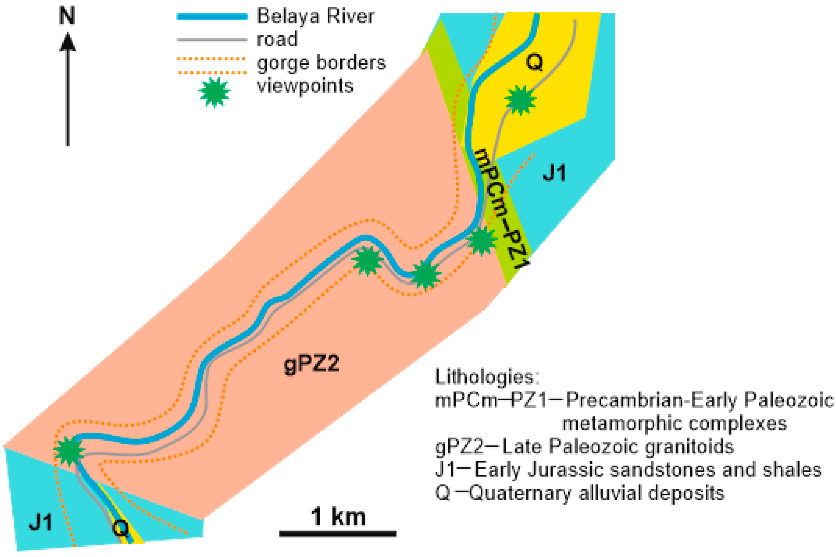
The Granite Gorge is a part of the Belaya River valley where it crosses hard rocks of the Dakh Crystalline Massif (Figure 2). Its length is ~5 km, and its total depth is measured by hundreds of meters. Generally, the gorge is V-shaped, but its lowest part is U-shaped resembling a canyon. The gorge is famous, first of all, for its characteristic geometry, lengthy granitoid outcrops, and spectacular viewpoints allowing observation of the geological activity of running water. Mountainous Adygeya is judged to be a geodiversity hotspot [7], and Granite Gorge displays a broad spectrum of unique geological phenomena [7,10,11]. This geosite is well-accessible because a road stretches along the entire gorge. Special maintenance of this site is unnecessary because crystalline rocks are hard and resistive to all environmental stresses, and human influence is minimal, except for very small constructions of souvenir vendors.

3. Methodology

A new field inventory of the geological heritage of the Granite Gorge was undertaken for the purposes of this study. Particularly, all unique features were identified in order to characterize them for subsequent interpretations. Attention was also paid to points of panoramic views, as the category of viewpoint geosites has been proposed recently [18,19].
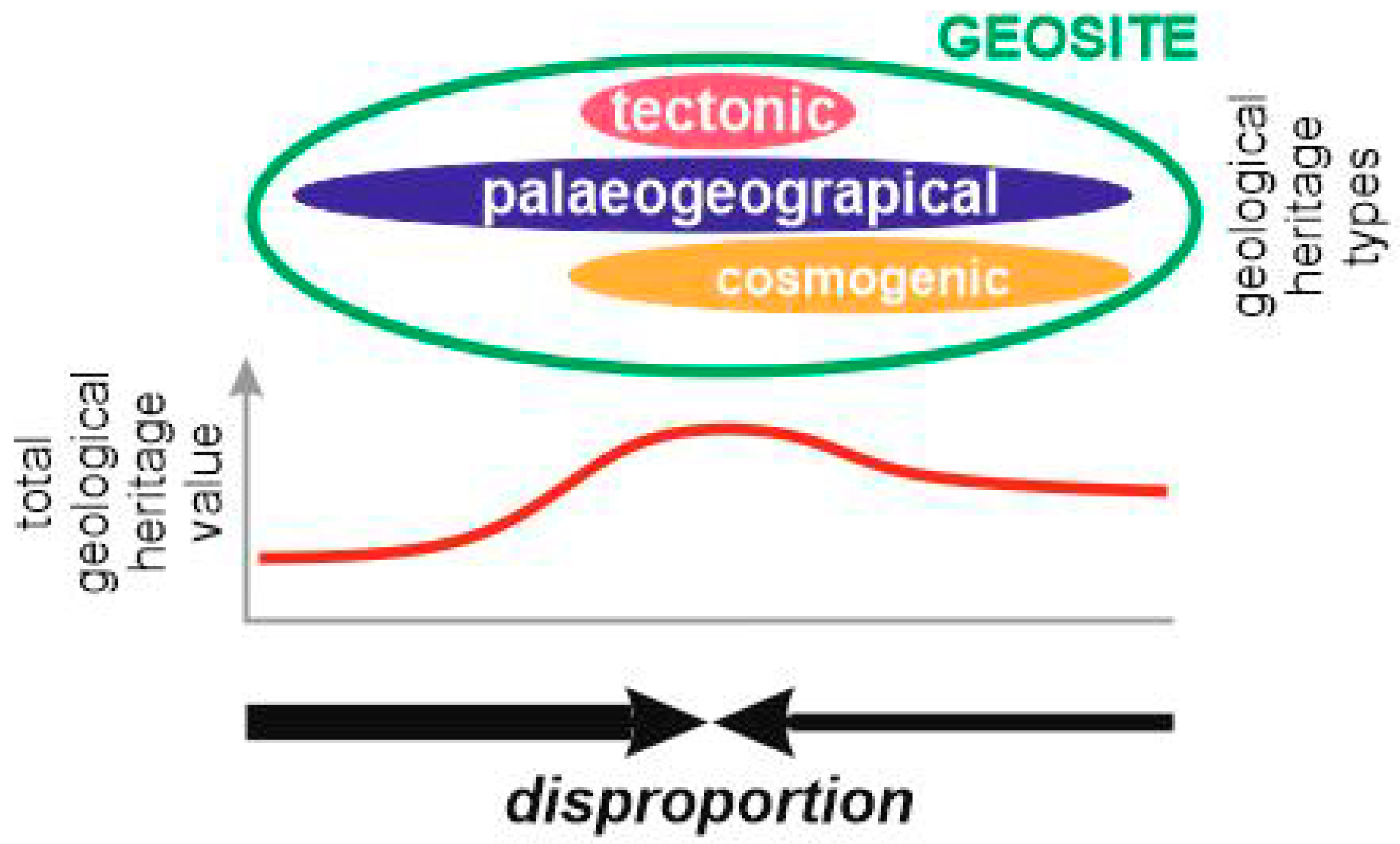
The new field information and the earlier-made interpretations [7,10,11] permit judgments of the geological heritage of the Granite Gorge. First, all unique features were attributed to the standardized types of geological heritage. The classification of Ruban [7] was employed for this purpose. Second, the uniqueness of these features depending on their too typical or too unusual appearance was established. The knowledge of the geographical distribution of similar phenomena was employed for this purpose. The result indicates the value (rank) of the relevant geological heritage, which can be local, regional, national, or global [7]. Third, the occurrence of the features along the gorge and the spatial distribution of the established types were mapped. This was necessary for judgments of presence/absence of concentration of the geological heritage in any part of the gorge, i.e., about this geosite’s disproportions (Figure 3).

4. Results

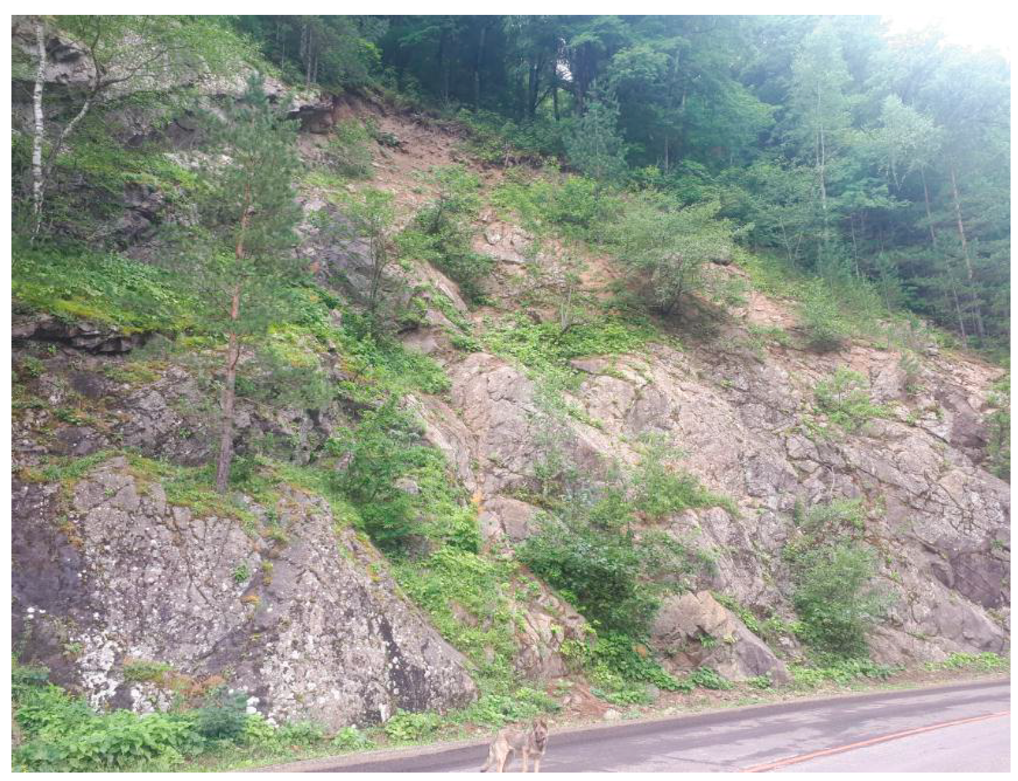
The unique features of the Granite Gorge geosite can be attributed to several geological heritage types, namely geomorphological, igneous, metamorphic, sedimentary, mineralogical, paleogeographical, tectonic, economic, engineering, and hydrological and hydrogeological types. Such a diversity of phenomena can be judged as almost unprecedented because of two circumstances. First, half of all known geological heritage types [7] were found in one geosite. Second, an unusual type coexistence (e.g., igneous and paleogeographical) was registered. The unique features occurred in natural and artificial (roadcuts and small quarries) outcrops/exposures, chiefly along the road stretching through the entire gorge (Figure 4). However, some features (geomorphological and hydrological and hydrogeological) occurred as landforms and landscape elements (Figure 5). Moreover, there were several viewpoints offering 180°-panoramic views of the gorge, rock outcrops on its slopes, and surrounding landforms (Figure 2). It should be also noted that the Granite Gorge is a geosite sensu lato because it comprises features of geosite sensu stricto (’purely’ geological heritage site) and geomorphosite (sensu Reynard et al. [20]). The particular features attributed to the above-listed types are specified and abbreviated below.
Geomorphological type: the gorge itself with its combined V- and U-shaped profile (see above) (Gm1), the Three Tooth Mountain with a peculiar shape of three peaks (Gm2), niches and rounded cavities (so-called ‘giant cups’ and ‘erosional bathes’) in granitoids formed by erosion of the Belaya River (Gm3).
Igneous type: Late Paleozoic granitoids, including granites and granodiorites with aplite dikes (Ig1), very peculiar rodingite dikes (rodingite is a rare, garnet-bearing rock closely related to ultramafic complexes, and its nature is somewhat debatable [21,22,23,24,25,26]) (Ig2).
Metamorphic type: Precambrian amphibolites and gneisses (Mt1), early Paleozoic serpentinite bodies (Mt2).
Sedimentary type: Linear weathering of granitoids (Sd1), Early Jurassic coarse siliciclastics (Sd2), modern alluvial deposits (Sd3).
Mineralogical type: A highly-peculiar and yet-to-be studied mineral assemblage (a presence of vesuvianite veins is possible) from the contact of the metamorphic rocks and the rodingite dyke (Mn1).
Paleogeographical type: Co-occurring metamorphic rocks of Gondwanan affinity and igneous rocks (granitoids) of Proto-Alpine affinity (Pg1), the Early Jurassic rocky shore facies (this facies is highly-specific and rare [27,28]) (Pg2).
Tectonic type: Joint and minor fault networks in granitoids (Tc1), protrusion body of serpentinites with tectonic contacts (Tc2), major shear zone with strike-slip motions (Tc3).
Economic type: Granitoids quarried for road construction (Ec1).
Engineering type: Active rockfalls on the gorge slopes (the data from the Granite Gorge would be suitable to test modern techniques of rockfall dating [29] (En1);
Hydrological and hydrogeological type: Geological activity (erosion and narrow valley incision) of the Belaya River (Hy1), ‘hanging mouths’ of small Belaya River tributaries ending with waterfalls (Hy2), and small springs (Hy3).
The above-mentioned features differ in their uniqueness (Table 1). The geomorphological, igneous, and paleogeographical phenomena seem to be especially valuable.
Inventory of the unique features implies that these tended to concentrate in two loci, namely a 1-km strip near the northern entrance to the gorge and a 1-km strip near the southern entrance to the gorge (Figure 6). Taken together, these loci constitute ~40% of the gorge length, which is the evidence of concentration. The first (northern) locus hosts the majority of the unique features. Spatial distribution of the geological heritage types implies the same kind of heterogeneity (Figure 5) and, thus, disproportion of the Granite Gorge geosite. The majority of the types occur near the northern entrance to the gorge. Finally, several viewpoints displaying panoramic views to unique geological features also occur within the same 1-km strip near the northern entrance to the gorge (Figure 2). The documented pattern of the unique features distribution within the study geosite implies that the geological heritage value is concentrated in some parts of this geosite, making the heritage value really disproportionate. Consideration of the value of each particular feature (Table 1) stresses this disproportion (Table 2). It should be noted that although the central part of the geosite hosts many notable geological features, including those with regional and national uniqueness, these features are often the same as available in the northern and southern parts of the geosite.

5. Discussion

The Granite Gorge appears to be an example of a big and complex geosite with significant disproportion. This observation raises several managerial challenges, which are specified and discussed below.
How correct is it to designate the entire Granite Gorge as a single geosite? In fact, a smaller geosite can be established to embrace the only 1-km strip of geological heritage concentration near the northern entrance to the gorge. However, such a solution is not reasonable because it does not take into account the geosite integrity. The Granite Gorge is a big, but single landform created by the same process, and the entire chain of exposures of the Late Paleozoic granites represents the Dakh Crystalline Massif. Moreover, there are features (e.g., labeled as Gm3 and Tc3) that occur outside the strip of heritage concentration. A smaller geosite will miss these features. If so, the entire Granite Gorge should be designated as a geosite.
Is it possible to focus the geosite conservation plan on the only loci of concentration of the unique features? Undoubtedly, these loci deserve special attention. However, their conservation should not be over-emphasized. For instance, uncontrolled waste storage or less attention to rock damage by occasional visitors in the central part of the gorge would affect the entire geosite because of its evident integrity (also visual). In such a case, it is sensible to sustain geoconservation activities along the entire gorge.
What does the registered geosite disproportion mean to geotourism? Mountainous Adygeya is a very popular tourist destination of southwestern Russia, and the Granite Gorge is among the most frequently visited attractions of this destination. It seems to be logical to consider the northern locus of geological heritage concentration as a geotourist attraction and to promote it as such. However, the integrity of the Granite Gorge is evident even to unprepared (occasional) (geo)tourists, and, thus, any artificial fragmentation would disturb perception of this attraction. A balanced geotourism use of the geosite should be preferred. The geosite conservation plan should pay attention to geotourism opportunities, and it should prescribe solutions making the entire gorge interesting to visitors. For instance, panels explaining the nature and the origin of the Late Paleozoic granites can be installed in the central part of the gorge to ’recompense’ the absence of multiple unique features and to avoid supply of too much information near the northern entrance.
What does the registered disproportion mean to this geosite attractiveness? On the one hand, Kirillova et al. [30] note that diversity and uniqueness are among criteria for judgments of beauty. If so, the concentrations of unique features near the northern and southern entrances to the gorge seem to be more attractive than the rest of the geosite. On the other hand, a route through the Granite Gorge provides experience that refers to some other criteria for judgments of beauty (at least, this experience permits to ‘feel’ the scale of the gorge and the strength of the geological and geomorphological processes that has led to its creation). Moreover, observation of the partial panorama of the gorge near the northern entrance creates visitor expectations about the entire landform and its geological context.
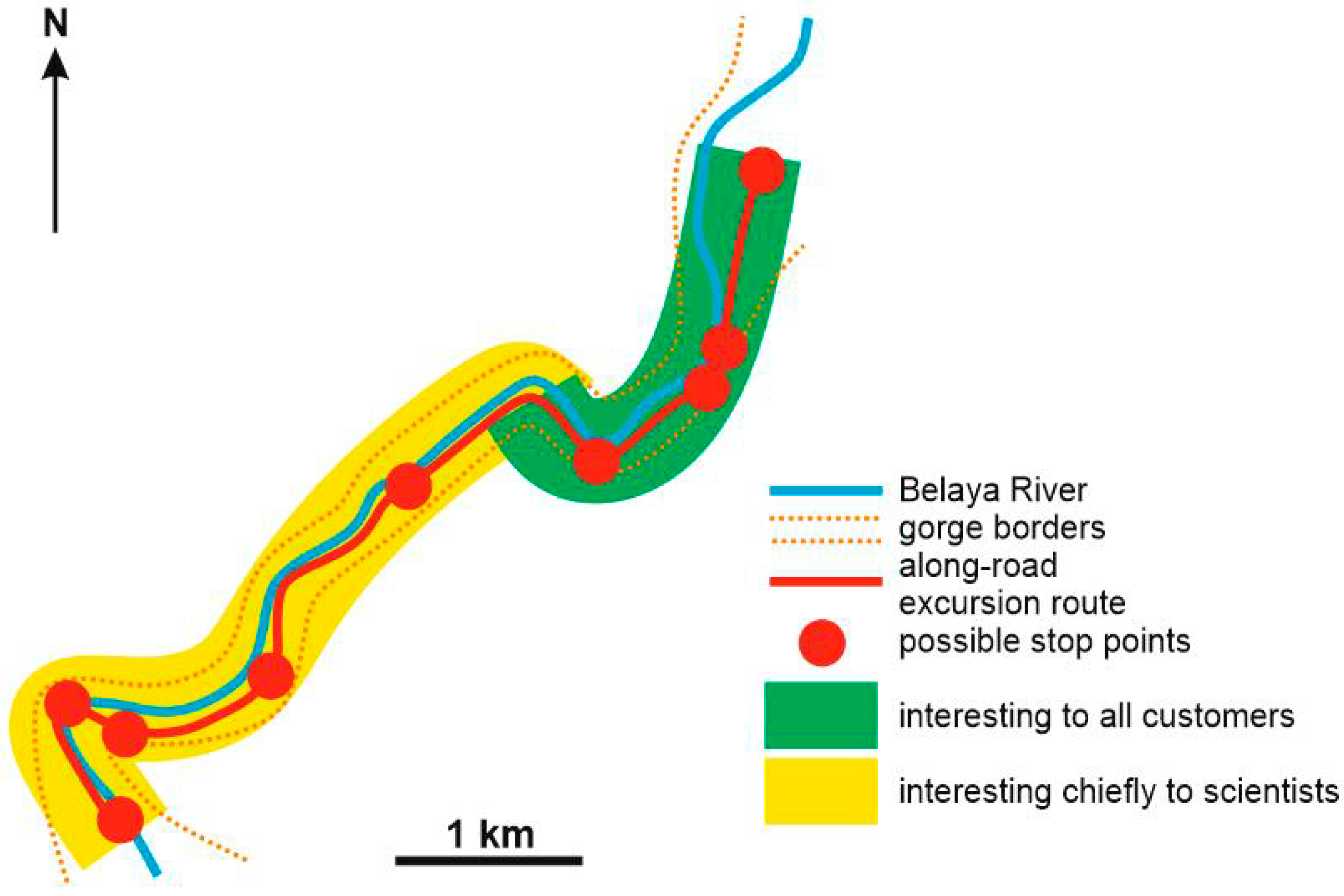
How sensible is to zone this geosite depending on the preferences of its potential visitors? Rózycka and Migon [31] have introduced an important idea of customer-oriented evaluation of geological heritage, which can be easily linked to the concept of customer-dominant logic in the modern theory of marketing [32,33,34,35,36,37]. In relation to geological heritage, potential customers are geoconservationists, geoscienctists, geoeducators, geotourists, and other occasional visitors. If so, different parts of the geosite can be specified for different customers (Figure 7). For instance, geoscientists may be very interested in the central part of the Granite Gorge because it permits investigation of a periphery–core transition of small granitoid intrusions. Any fixed zonation may further result into a functional plan for efficient geosite management. Virtual approaches aimed at particular categories of customers (e.g., [38]) can be further implemented, and this requires special investigations.

6. Conclusions

The undertaken investigation of the Granite Gorge geosite in southwestern Russia exhibiting the deep valley of the Belaya River, the Late Paleozoic granitoids, and many other notable geological features permits making two general conclusions. First, this big and complex geosite is highly disproportionate in regard to the spatial occurrence of its unique features, geological heritage types, and feature uniqueness. Second, the registered disproportions highlight several challenges to the geosite managers, but these do not limit geoconservation and geotourism importance of the entire geosite. Further studies of the phenomenon of geosite disproportions are necessary in order to equip geoconservationists with a template of the relevant managerial decisions. The outcomes of the present study imply that the factor of disproportions should not be ignored in geosites inventory.

Author Contributions

Conceptualization, D.A.R. and N.N.Y.; field works, A.V.M. and D.A.R.; methodology, D.A.R. and N.N.Y.; investigation, A.V.M., D.A.R. and M.B.R.; writing, D.A.R. and M.B.R.

Funding

This research received no external funding.

Acknowledgments

The authors gratefully thank the journal editor and three reviewers for their thorough consideration of this paper and very helpful recommendations.

Conflicts of Interest

The authors declare no conflict of interest.

References

  1. Brown, E.J.; Evans, D.H.; Larwood, J.G.; Prosser, C.D.; Townley, H.C. Geoconservation and geoscience in England: A mutually beneficial relationship. Proc. Geol. Assoc. 2018, 129, 492–504. [Google Scholar] [CrossRef]
  2. Henriques, M.H.; Pena dos Reis, R.; Brilha, J.; Mota, T. Geoconservation as an Emerging Geoscience. Geoheritage 2011, 3, 117–128. [Google Scholar] [CrossRef] [Green Version]
  3. Reynard, E.; Brilha, J. Geoheritage: Assessment, Protection, and Management; Elsevier: Amsterdam, The Netherlands, 2018; pp. 1–482. [Google Scholar]
  4. Wimbledon, W.A.P.; Smith-Meyer, S. Geoheritage in Europe and Its Conservation; ProGEO: Oslo, Norway, 2012; pp. 1–405. [Google Scholar]
  5. Henriques, M.H.; Brilha, J. UNESCO Global Geoparks: A strategy towards global understanding and sustainability. Episodes 2017, 40, 349–355. [Google Scholar] [CrossRef]
  6. Ruban, D.A. Geodiversity as a precious national resource: A note on the role of geoparks. Resour. Policy 2017, 53, 103–108. [Google Scholar] [CrossRef]
  7. Ruban, D.A. Quantification of geodiversity and its loss. Proc. Geol. Assoc. 2010, 121, 326–333. [Google Scholar] [CrossRef]
  8. Bentivenga, M.; Palladino, G.; Prosser, G.; Guglielmi, P.; Geremia, F.; Laviano, A. A Geological Itinerary Through the Southern Apennine Thrust Belt (Basilicata—Southern Italy). Geoheritage 2017, 9, 1–17. [Google Scholar] [CrossRef]
  9. Nazaruddin, D.A. Selected geosites for geoheritage, geotourism, and geoconservation in Songkhla Province, Southern Thailand. Quaest. Geogr. 2019, 38, 161–177. [Google Scholar] [CrossRef]
  10. Ruban, D.A.; Pugachev, V.I. The Khadzhokhsky canyon and the Granitnoye gorge (Adygeia, Russia) as geological natural monuments. Geogr. Nat. Resour. 2008, 29, 50–53. [Google Scholar] [CrossRef]
  11. Plyusnina, E.E.; Ruban, D.A.; Zayats, P.P. Thematic dimension of geological heritage: An evidence from the Western Caucasus. J. Geogr. Inst. “Jovan Cvijić” SASA 2015, 65, 59–76. [Google Scholar] [CrossRef]
  12. Adamia, S.; Alania, V.; Chabukiani, A.; Kutelia, Z.; Sadradze, N. Great Caucasus (Cavcasioni): A Long-lived North-Tethyan Back-Arc Basin. Turk. J. Earth Sci. 2011, 20, 611–628. [Google Scholar]
  13. Alekseeva, A.E.; Ershov, A.V.; Linev, D.N. Numerical modeling of uplift and erosion at the Western Caucasus orogen in the Neogene-Quaternary. Mosc. Univ. Geol. Bull. 2014, 69, 213–218. [Google Scholar] [CrossRef]
  14. Forte, A.M.; Cowgill, E.; Whipple, K.X. Transition from a singly vergent to doubly vergent wedge in a young orogen: The Greater Caucasus. Tectonics 2014, 33, 2077–2101. [Google Scholar] [CrossRef]
  15. Rolland, Y. Caucasus collisional history: Review of data from East Anatolia to West Iran. Gondwana Res. 2017, 49, 130–136. [Google Scholar] [CrossRef]
  16. Yilmaz, A.; Adamia, S.; Yilmaz, H. Comparisons of the suture zones along a geotraverse from the Scythian Platform to the Arabian Platform. Geosci. Front. 2014, 5, 855–875. [Google Scholar] [CrossRef] [Green Version]
  17. Ruban, D.A. The Greater Caucasus—A Galatian or Hanseatic terrane? Comment on “The formation of Pangea” by G.M. Stampfli, C. Hochard, C. Vérard, C. Wilhem and J. von Raumer [Tectonophysics 593 (2013) 1-19]. Tectonophysics 2013, 608, 1442–1444. [Google Scholar] [CrossRef]
  18. Migoń, P.; Pijet-Migoń, E. Viewpoint geosites—Values, conservation and management issues. Proc. Geol. Assoc. 2017, 128, 511–522. [Google Scholar] [CrossRef]
  19. Mikhailenko, A.V.; Ruban, D.A. Environment of Viewpoint Geosites: Evidence from the Western Caucasus. Land 2019, 8, 93. [Google Scholar] [CrossRef]
  20. Reynard, E.; Fontana, G.; Kozlik, L.; Scapozza, C. A method for assessing the scientific and additional values of geomorphosites. Geogr. Helv. 2007, 62, 148–158. [Google Scholar] [CrossRef]
  21. Bach, W.; Klein, F. The petrology of seafloor rodingites: Insights from geochemical reaction path modeling. Lithos 2009, 112, 103–117. [Google Scholar] [CrossRef]
  22. De, A. Petrology of dikes emplaced in the ultramafic rocks of southeastern Quebec and origin of the rodingite. Mem. Geol. Soc. Am. 1972, 132, 489–501. [Google Scholar]
  23. Dubinska, E. Rodingites and amphibolites from the serpentinites surrounding Sowie Góry block (Lower Silesia, Poland): Record of supra-subduction zone magmatism and serpentinization. Neues Jahrb. Mineral. Abh. 1997, 171, 239–279. [Google Scholar]
  24. Koller, F.; Richter, W. Rodingites in ultramafic rocks of the eastern Alps. Ofioliti 1980, 5, 73–78. [Google Scholar]
  25. Surour, A.A. Mid-ocean ridge vs. forearc and subduction settings: Clues from rodingitization of tectonic fragments in the Neoproterozoic ophiolites of the Eastern Desert, Egypt. Lithos 2019, 342–343, 18–30. [Google Scholar] [CrossRef]
  26. Zanoni, D.; Rebay, G.; Spalla, M.I. Ocean floor and subduction record in the Zermatt-Saas rodingites, Valtournanche, Western Alps. J. Metamorph. Geol. 2016, 34, 941–961. [Google Scholar] [CrossRef]
  27. Johnson, M.E. Why are ancient rocky shores so uncommon? J. Geol. 1988, 96, 469–480. [Google Scholar] [CrossRef]
  28. Johnson, M.E. Hunting for ancient rocky shores. J. Geol. Educ. 1988, 36, 147–154. [Google Scholar] [CrossRef]
  29. Trappmann, D.; Corona, C.; Stoffel, M. Rolling stones and tree rings: A state of research on dendrogeomorphic reconstructions of rockfall. Prog. Phys. Geogr. 2013, 37, 701–716. [Google Scholar] [CrossRef]
  30. Kirillova, K.; Fu, X.; Lehto, X.; Cai, L. What makes a destination beautiful? Dimensions of tourist aesthetic judgment. Tour. Manag. 2014, 42, 282–293. [Google Scholar] [CrossRef]
  31. Rózycka, M.; Migon, P. Customer-Oriented Evaluation of Geoheritage—On the Example of Volcanic Geosites in the West Sudetes, SW Poland. Geoheritage 2018, 10, 23–37. [Google Scholar] [CrossRef]
  32. Cheung, F.Y.M.; To, W.M. A customer-dominant logic on service recovery and customer satisfaction. Manag. Decis. 2016, 54, 2524–2543. [Google Scholar] [CrossRef]
  33. Cheung, M.F.Y.; To, W.M. Do task- and relation-oriented customers co-create a better quality of service? An empirical study of customer-dominant logic. Manag. Decis. 2015, 53, 179–197. [Google Scholar] [CrossRef]
  34. Heinonen, K.; Strandvik, T. Customer-dominant logic: Foundations and implications. J. Serv. Mark. 2015, 29, 472–484. [Google Scholar] [CrossRef]
  35. Heinonen, K.; Strandvik, T. Reflections on customers’ primary role in markets. Eur. Manag. J. 2018, 36, 1–11. [Google Scholar] [CrossRef]
  36. Lemmink, J.; Franzelova, I.; Säaksjärvi, M.; Heinonen, K. Customer-dominant logic and the need for exploring app usage in different customer contexts. J. Indian Bus. Res. 2019, 11, 50–59. [Google Scholar] [CrossRef]
  37. Tynan, C.; McKechnie, S.; Hartley, S. Interpreting value in the customer service experience using customer-dominant logic. J. Mark. Manag. 2014, 30, 1058–1081. [Google Scholar] [CrossRef]
  38. Martinez-Grana, A.; Gonzalez-Delgado, J.A.; Pallares, S.; Goy, J.L.; Civis Llovera, J. 3D Virtual Itinerary for Education Using Google Earth as a Tool for the Recovery of the Geological Heritage of Natural Areas: Application in the “Las Batuecas Valley” Nature Park (Salamanca, Spain). Sustainability 2014, 6, 8567–8591. [Google Scholar] [CrossRef]
Figure 1. Location of the study geosite.
Geosciences 09 00372 g001
Figure 2. Geographical plan and geology of the Granite Gorge.
Geosciences 09 00372 g002
Figure 3. Conceptual representation of the idea of big and complex geosite disproportion. Arrows indicate increase in geological heritage concentration (the wider the arrow, the bigger the increase). The geological heritage types are chosen provisionally just to give an example, and it is supposed that all types are valued equally in this example.
Geosciences 09 00372 g003
Figure 4. A typical crystalline rock exposure along the road in the Granite Gorge. Dog stays for scale.
Geosciences 09 00372 g004
Figure 5. General view of the Granite Gorge near the northern entrance. The combination of V- and U-shaped gorge profiles, granitoid outcrops, and the Belaya River are visible.
Geosciences 09 00372 g005
Figure 6. Schematic distribution of geological features along the Granite Gorge; abbreviations of geological heritage types: Gm, geomorphological; Ig, igneous; Mt, metamorphic; Sd, sedimentary; Mn, mineralogical; Pg, paleogeographical; Tc, tectonic; Ec, economic; En, engineering; Hy, hydrological and hydrogeological (numbers refer to particular features and are explained in the text).
Geosciences 09 00372 g006
Figure 7. A tentative zonation of the Granite Gorge geosite depending on the expected customer preferences.
Geosciences 09 00372 g007
Table 1. Uniqueness of the geological features of the Granite Gorge geosite.
Geological Heritage FeaturesLocal Occurrence of Similar PhenomenaRegional Occurrence of Similar PhenomenaNational Occurrence of Similar PhenomenaGlobal Occurrence of Similar PhenomenaUniqueness of the Feature
Gm1++++++National
Gm2+++++++++++Local
Gm3++++++++++++Local
Ig1++++++++Regional
Ig2+++++National
Mt1+++++++++Local
Mt2++++++++Regional
Sd1++++++++Regional
Sd2++++++++++++Local
Sd3++++++++++++Local
Mn1+???Local?
Pg1+++++National
Pg2+++++National
Tc1++++++++Regional
Tc2+++++++++Local
Tc3++++++++++Local
Ec1++++++++++Local
En1++++++++++++Local
Hy1++++++++Regional
Hy2++++++++++Local
Hy3++++++++++++Local
Note: + rare occurrence (unique features), ++ moderate occurrence (restricted number of features), +++ frequent occurrence (abundant features), ? indicates questionable occurrence.
Table 2. Disproportion of the Granite Gorge geosite determined by the different uniqueness of the geological heritage features.
Part of GeositeFeaturesNumber of Regionally (R) and Nationally (N) Unique Features
NorthernGm1, Gm3, Ig1, Ig2, Mt1, Mt2, Sd2, Sd3, Mn1, Pg1, Pg2, Tc1, Tc2, En1, Hy1, Hy2R = 4, N = 4
CentralGm1, Gm2, Gm3, Ig1, Sd1, Tc1, Ec1, En1, Hy1, Hy2, Hy3R = 4, N = 1
SouthernGm1, Gm3, Ig1, Sd3, Tc1, Tc3, Hy1R = 3, N = 1