Dispersed Geoheritage Points of the Lagonaki Highland, SW Russia: Contribution to Local Geoheritage Resource


Abstract
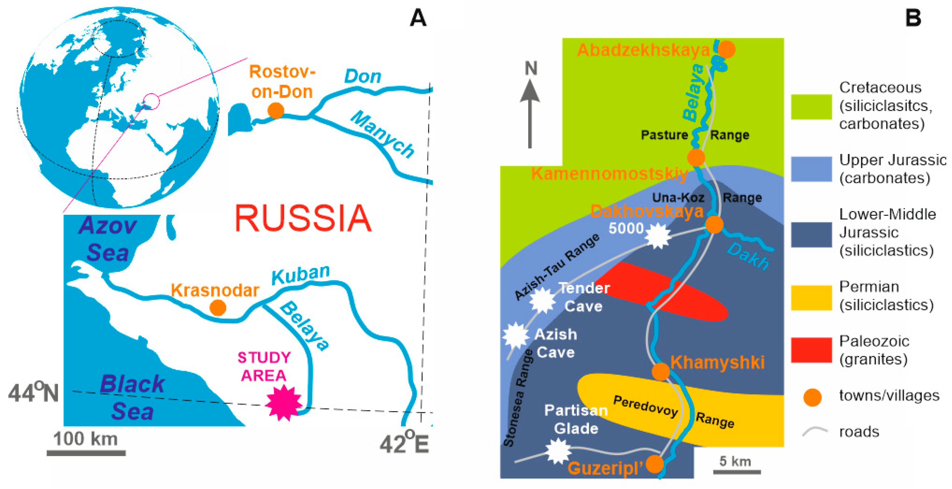
:1. Introduction
2. Materials and Methods
3. Results
4. Discussion and Conclusion
Author Contributions
Funding
Acknowledgments
Conflicts of Interest
References
- Bétard, F.; Hobléa, F.; Portal, C. Geoheritage as new territorial resource for local development. Ann. Geogr. 2017, 717, 523–543. [Google Scholar] [CrossRef]
- Brilha, J.; Gray, M.; Pereira, D.I.; Pereira, P. Geodiversity: An integrative review as a contribution to the sustainable development of the whole of nature. Environ. Sci. Policy 2018, 86, 19–28. [Google Scholar] [CrossRef]
- Gray, M. Geodiversity. Valuing and Conserving Abiotic Nature; Wiley-Blackwell: Chichester, UK, 2013; pp. 1–495. [Google Scholar]
- Mikhailenko, A.V.; Ruban, D.A. Geo-Heritage specific visibility as an important parameter in geo-tourism resource evaluation. Geosci. 2019, 9, 146. [Google Scholar] [CrossRef]
- Muda, J.; Tongkul, F. Geoheritage resources of the Baliajong River: Potential for geotourism development. Bull. Geol. Soc. Malays. 2008, 54, 139–145. [Google Scholar] [CrossRef]
- Ruban, D.A. Geodiversity as a precious national resource: A note on the role of geoparks. Resour. Policy 2017, 53, 103–108. [Google Scholar] [CrossRef]
- Wang, H.; Li, J.; Wu, T. Characteristics and Genesis of Geoheritage Resources of Taihang Mountain. Beijing Daxue Xuebao (Ziran Kexue Ban)/Acta Sci. Nat. Univ. Pekin. 2018, 54, 546–554. [Google Scholar]
- Brilha, J. Inventory and Quantitative Assessment of Geosites and Geodiversity Sites: A Review. Geoheritage 2016, 8, 119–134. [Google Scholar] [CrossRef]
- Bruschi, V.M.; Cendrero, A. Geosite evaluation; can we measure intangible values? Il Quat. 2005, 18, 293–306. [Google Scholar]
- Reynard, E.; Brilha, J. (Eds.) Geoheritage: Assessment, Protection, and Management; Elsevier: Amsterdam, The Netherlands, 2018; pp. 1–482. [Google Scholar]
- Migoń, P.; Pijet-Migoń, E. Viewpoint geosites – values, conservation and management issues. Proc. Geol. Assoc. 2017, 128, 511–522. [Google Scholar] [CrossRef]
- Ruban, D.A. Aesthetic properties of geological heritage landscapes: Evidence from the Lagonaki Highland (Western Caucasus, Russia). J. Geogr. Inst. “Jovan Cvijić” SASA 2018, 68, 289–296. [Google Scholar] [CrossRef]
- Adamia, S.; Alania, V.; Chabukiani, A.; Kutelia, Z.; Sadradze, N. Great Caucasus (Cavcasioni): A Long-lived North-Tethyan Back-Arc Basin. Turk. J. Earth Sci. 2011, 20, 611–628. [Google Scholar]
- Guo, L.; Vincent, S.J.; Lavrishchev, V. Upper Jurassic Reefs from the Russian Western Caucasus: Implications for the Eastern Black Sea. Turk. J. Earth Sci. 2011, 20, 629–653. [Google Scholar]
- Ruban, D.A. The siliciclastics/carbonates shift in the Jurassic of the Western Caucasus (central northern Neo-Tethys): Reconsidering research over the last 50 years. Geol. 2019, 25, 153–162. [Google Scholar]
- Saintot, A.; Brunet, M.-F.; Yakovlev, F.; Sébrier, M.; Stephenson, R.; Ershov, A.; Chalot-Prat, F.; McCann, T. The Mesozoic-Cenozoic tectonic evolution of the Greater Caucasus. Geol. Soc. Lond. Mem. 2006, 32, 277–289. [Google Scholar] [CrossRef] [Green Version]
- Veress, M.; Telbisz, T.; Tóth, G.; Lóczy, D.; Ruban, D.A.; Gutak, Ja.M. Glaciokarsts; Springer: Cham, Switzerland, 2019; pp. 1–516. [Google Scholar]
- Reitner, J. Phylogenie und Konvergenzen bei rezenten und fossilen Calcarea (Porifera) mit einem kalkigen Basalskelett (“Inozoa”, “Pharetronida”). Berl. Geowiss. Abh. (A) 1987, 86, 87–125. [Google Scholar]
- Nazaruddin, D.A.; Mansor, H.E.; Wali, S.S.A.S. Geoheritage of Labuan island. Bull. Geol. Soc. Malays. 2016, 62, 117–129. [Google Scholar] [CrossRef]
- Phuong, T.H.; Cu, N.H.; Thanh, T.D.; Van Dong, B. Geoheritage values in the Cat Ba islands, Vietnam. Environ. Earth Sci. 2013, 70, 543–548. [Google Scholar] [CrossRef]
- Bruschi, V.M.; Cendrero, A.; Albertos, J.A.C. A statistical approach to the validation and optimisation of geoheritage assessment procedures. Geoheritage 2011, 3, 131–149. [Google Scholar] [CrossRef]
- Fassoulas, C.; Mouriki, D.; Dimitriou-Nikolakis, P.; Iliopoulos, G. Quantitative assessment of geotopes as an effective tool for geoheritage management. Geoheritage 2012, 4, 177–193. [Google Scholar] [CrossRef]
- Forte, J.P.; Brilha, J.; Pereira, D.I.; Nolasco, M. Kernel Density Applied to the Quantitative Assessment of Geodiversity. Geoheritage 2018, 10, 205–217. [Google Scholar] [CrossRef] [Green Version]
- Gordon, J.E. Geoheritage, geotourism and the cultural landscape: Enhancing the visitor experience and promoting geoconservation. Geosciences 2018, 8, 136. [Google Scholar] [CrossRef]
- Melelli, L.; Vergari, F.; Liucci, L.; Del Monte, M. Geomorphodiversity index: Quantifying the diversity of landforms and physical landscape. Sci. Total. Environ. 2017, 584–585, 701–714. [Google Scholar] [CrossRef] [PubMed]
- Nazaruddin, D.A. Selected geosites for geoheritage, geotourism, and geoconservation in Songkhla Province, Southern Thailand. Quaest. Geogr. 2019, 38, 161–177. [Google Scholar] [CrossRef]
- Pereira, P.; Pereira, D.I. Methodological guidelines for geomorphosite assessment. Geomorphol Relief Process. Env. 2010, 2, 215–222. [Google Scholar] [CrossRef]
- Reynard, E.; Perret, A.; Bussard, J.; Grangier, L.; Martin, S. Integrated approach for the inventory and management of geomorphological heritage at the regional scale. Geoheritage 2016, 8, 43–60. [Google Scholar] [CrossRef]
- Serrano, E.; Ruiz-Flano, P. Geodiversity. A theoretical and applied concept. Geogr. Helv. 2007, 62, 140–147. [Google Scholar] [CrossRef]


| Element | Content (ppm) |
|---|---|
| Li | 1.64–2.54 |
| Be | 0.14–0.15 |
| Ti | 88.07–93.23 |
| V | 4.29–7.64 |
| Cr | 5.60–8.52 |
| Mn | 77.05–204.64 |
| Co | 1.21–2.13 |
| Ni | 7.59–12.31 |
| Cu | 3.62–8.50 |
| Zn | 27.00–63.23 |
| Ga | 1.06–1.51 |
| Se | 1–83 |
| Rb | 2.92–2.99 |
| Sr | 141.65–207.90 |
| Y | 8.38–17.00 |
| Zr | 2.64–3.12 |
| Nb | 0.26–0.30 |
| Mo | 0.33 |
| Cd | 0.32–0.86 |
| Ba | 11.43–12.73 |
| W | 0.06–0.08 |
| Pb | 1.90–2.13 |
© 2019 by the authors. Licensee MDPI, Basel, Switzerland. This article is an open access article distributed under the terms and conditions of the Creative Commons Attribution (CC BY) license (http://creativecommons.org/licenses/by/4.0/).
Share and Cite
Ruban, D.A.; Zorina, S.O.; Rebezov, M.B. Dispersed Geoheritage Points of the Lagonaki Highland, SW Russia: Contribution to Local Geoheritage Resource. Geosciences 2019, 9, 367. https://doi.org/10.3390/geosciences9090367
Ruban DA, Zorina SO, Rebezov MB. Dispersed Geoheritage Points of the Lagonaki Highland, SW Russia: Contribution to Local Geoheritage Resource. Geosciences. 2019; 9(9):367. https://doi.org/10.3390/geosciences9090367
Chicago/Turabian StyleRuban, Dmitry A., Svetlana O. Zorina, and Maksim B. Rebezov. 2019. "Dispersed Geoheritage Points of the Lagonaki Highland, SW Russia: Contribution to Local Geoheritage Resource" Geosciences 9, no. 9: 367. https://doi.org/10.3390/geosciences9090367
APA StyleRuban, D. A., Zorina, S. O., & Rebezov, M. B. (2019). Dispersed Geoheritage Points of the Lagonaki Highland, SW Russia: Contribution to Local Geoheritage Resource. Geosciences, 9(9), 367. https://doi.org/10.3390/geosciences9090367