1. Introduction
To measure terrain, surface features, position coordinates, heights, and gravity values at points on the Earth’s surface, there need to be corresponding reference points [
1]. Geodetic point fields play the most crucial role in the attainable accuracy and reliability of surveying and mapping applications [
2]. The information about the geodetic point fields are gathered and managed by relevant bodies, such as land survey offices. The amount of data used is sufficient to store and manage inside a database management system with spatial extension. The spatial databases have been defined as database systems with a model and query language that support spatial data types and provide indexing efficient algorithms for spatial query processing [
3]. The conceptual data model of a spatial database must then allow storing all the requested information to meet the user requirements. The integration of spatial data into traditional database system requires addressing nontrivial issues at various levels [
4], while the inconsistency issues involved with dealing for instance with geometric representation also have to be considered during their implementation [
5]. The responsible institutions around the world are making the information about the geodetic point fields available, often online in the web environment. The Swiss Federal Office of Topography (Swisstopo) manages the control points data used in national surveying and in the official cadastral survey from a central database, which can only be accessed by the cantonal authorities and Swisstopo itself. In addition, Swisstopo has made the control point information available online for third parties by creating an extract from the production database and making it accessible via the Federal Geodata Portal [
6]. In Queensland, Australia, all permanent survey marks are registered in the Survey Control Database (SCDB), which includes coordinates, height, access notes and other administrative information. The survey control information is then published through the Queensland Globe [
7], which is data online interactive tool to explore the spatial data. Another example is Ontario, Canada, using COSINE [
8] (Control Survey Information Exchange), Ontario’s geodetic control database.
A user who works with these front-end systems with an aim of receiving the information about the particular geodetic point does not care about a database background. The architecture often has more spatial databases, every with its own data model, containing information about single type of geodetic point field (e.g., horizontal, vertical or gravitational). The front-end system, such as an online geoportal, can then enable a user to access, search and retrieve the requested information from one central point. The geoportal acts as a broker between spatial data providers and users [
9], for example between the Land Survey Office and private surveyors in the case of geodetic point fields. It is important to provide data about the point fields in this way as the geoportal is a cornerstone of the Spatial Data Infrastructure (SDI) [
10,
11]. However, such distributed architecture requires to maintain and manage all particular spatial databases separately. This can cause some difficulties, i.e., usage of various technologies (spatial database management systems) and so the increased cost for the maintenance of the system. Also during the actualization of the information about the geodetic control networks, it must be checked that the data (theoretically stored in several data models) were updated accordingly.
The aim of this paper is to propose an optimized data model which will integrate the data about all the types of geodetic point fields in one spatial database, reflect the user requirements, and enable effective spatial data management. Furthermore, the newly implemented spatial database is a part of the developed prototype of the Information system of geodetic point fields and so the whole system must preserve the support for all necessary processes as they are described in the existing system documentations. The main processes deal with spatial data loading, updating, dissemination and visualization. Also, an implementation of features dealing with cyber-security is considered.
It is also obvious that the importance of geodetic point fields is changing due to the development of technologies and international cooperation based on international standards. For example, in Europe, the International Association of Geodesy (IAG) Reference Sub-Commission [
12] (EUREF) is an umbrella organization for these standardization activities. The EUREF work is focused on definition, realization and maintenance of the European Geodetic Reference Systems. This effort is further supported by the International Association of Geodesy [
13] and EuroGeographics [
14], which is an independent international not-for-profit organization representing Europe’s National Mapping, Cadastral and Land Registration Authorities. Currently, the European Geodetic Reference System is composed of the European Terrestrial Reference System 89 (ETRS89) and the European Vertical Reference System (EVRS) [
15]. Furthermore, the European Combined Geodetic Network (ECGN) is going to be established in the near future. As proclaimed by EUREF, this network combines measurements of the Global Navigation Satellite Systems (GNSS) and other space techniques with gravity and leveling measurements. As argued in reference [
16], the importance of the European Reference Systems will be increasing in the future. Considering the existing geodetic point fields, the selected geodetic points will be integrated into the European Reference Systems and the corresponding coordinates will be determined. Another important activity is building of the Infrastructure for Spatial Information in Europe (INSPIRE) supporting environmental policies and activities [
17]. These international activities should be therefore also taken into consideration during the development of the spatial database serving for the integrated management of geodetic point fields. This paper describes a feasible “show case”, which could be used as a type of guideline for others conducting or planning a similar application.
The rest of the paper is structured as follows:
Section 2 describes the used methodology aiming to develop the integrated spatial database of geodetic point fields. The development is based on the analysis of the current solution, which is discussed in
Section 3.
Section 4 and
Section 5 describe the user and legislative requirements. The details about the integrated spatial database and the prototype of the Information system of geodetic point fields are given in
Section 6 and
Section 7, respectively. The conclusions are mentioned in
Section 8.
2. Methodology
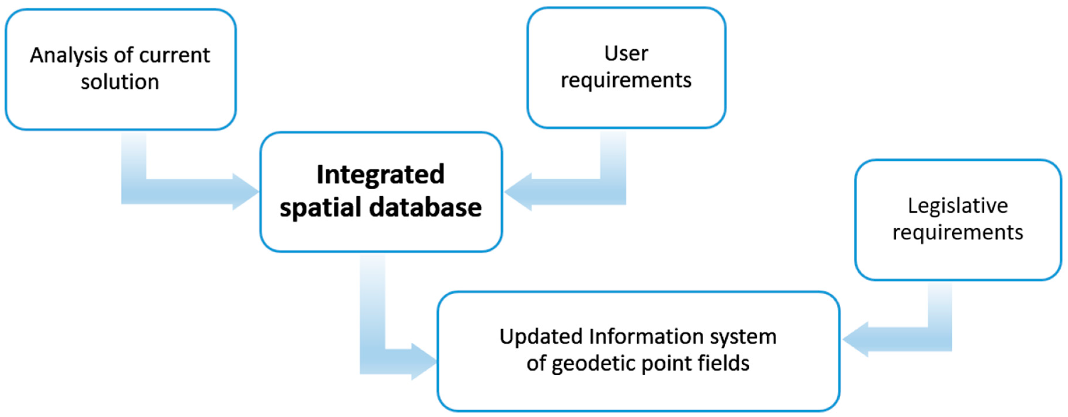
The proposal of the data model of the integrated spatial database started with the analysis of current solution. There were three separate solutions with particular data models. The internal documentation contained the detail information about all the processes upon the data models, which must be preserved by the new integrated spatial database and developed prototype of the Information system of geodetic point fields. As the existing data models are implemented in various technological environments, the mapping of the used data types and database objects must be considered.
The main user requirement on the new spatial database was the effective data management based on an integration of existing heterogeneous data models into one common data model. The newly proposed integrated spatial database serves then as a data layer in the architecture of the prototype of the Information system of geodetic point fields. The developed prototype also encapsulates the legislative requirements, especially the relevant law on cyber-security. The principle of the methodology is captured in
Figure 1.
3. Analysis of the Current Solution
The horizontal, vertical and gravitational geodetic point fields were built in the past in the Czech Republic. The high quality reference framework has been created, determined in all three components, satisfying the demands of follow-up detailed surveying, surveying of parcel borders, line and other constructions etc. The point fields became the basis for defining of the gradually introduced and utilized coordinate systems in the territory of the Czech Republic. Therefore, it is necessary to take care of the physical representation of geodetic points in the field. The administration of geodetic point fields of the Czech Republic is performed by the Land Survey Office (LSO). The LSO makes decisions about localization, transfer or removal of survey marks of the fundamental ground control in conformity with the Act Nr. 359/1992 Col. on Surveying, Mapping and Cadastre Bodies. According to this law, the points of fundamental geodetic point fields are set, maintained and renewed by the department of geodetic control at LSO.
The information about the geodetic point fields are stored in three separated databases, which are administered by the department of geodetic control in the Land Survey Office. Geodetic point fields comprise from monumented geodetic points with known coordinates in mandatory reference systems. The databases contain:
Trigonometric and densification points (horizontal point field). There are approximately 75 thousands centers of trigonometric points and densification points and more than 35 thousand associated points. All changes of coordinates are stored in the database of the horizontal point field. The points of minor control administered in the frame of Information system of the cadastre of real estate have also been published in the database of horizontal point field.
Leveling points (vertical point field). The database of leveling points contains 12 vertical datum points, 16 thousand points of the first order of the Czech state leveling network, 20 thousand points of the second order and 47 thousand points of the third order. It also contains the points of the fourth order and points of the surface leveling.
Gravity points (gravitational point field). The database of gravitational point field consists of 460 points of the Czech gravity network.
The data stored inside the databases are managed and accessible via the Information system of geodetic point fields. From the user’s perspective, it is a unified information system, however, it consists of three separate subsystems based on databases with different data models and technology. The information about the horizontal point field are stored in the spatial database based on Oracle, whereas the information about the vertical and gravitational point field are stored in the FoxPro database.
4. User Requirements
The several user groups of the Information system of geodetic point fields can be identified:
The private surveyors, who do the surveying activities for the benefit of the public.
The users entering and updating the data (the employees of cadastral offices and the Land Survey Office). The database contains the point number or name, identification of the registration unit, point coordinates or its height or gravity, data on associated points, location of the point, data on the point stability and its restoration and location (district, municipality, cadastral unit, map sheet index).
The experts performing tasks at various government units (e.g., the Czech Office for Surveying, Mapping and Cadastre, The Ministry of Defense, The Ministry of Transportation, The Ministry of the Environment, The Ministry of the Agriculture and others).
Professional public.
Data modeling is a critical stage of database design [
18]. The Land Survey Office’s main requirement (as the administrator of the database) was to integrate the several existing data models into one common data model based on Oracle Spatial technology. Oracle Spatial is a spatial database management system which supports Standard Query Language (SQL) and a collection of special functions to facilitate storage, retrieving, manipulation and updating of spatial data [
19]. Oracle Spatial database has been used for storage and management of spatial data dealing with land management [
20,
21], which is in a close relation to the geodetic points fields. The database of geodetic point fields then contains geodetic control data for the whole territory of the Czech Republic, which can be used for determining of the location of objects in the required reference systems.
The information system of geodetic point fields has to enable the entering, editing and managing of the data about the geodetic points (these tasks are done mostly by the employees of cadastral offices and the Land Survey Office) and also to provide the functionality for their dissemination to make the data accessible for the wide professional public. The providing of information about the geodetic point fields is a prerequisite for efficient activities.
If an inconsistency between the registered and real situation is discovered, it can be reported to the Land Surveying Office via the web form. This helps to keep the data up-to-date, which is necessary for the effective decision-making processes in public administration.
The professional surveyors also require the modern way of accessing the information about the geodetic point fields. The database of geodetic point fields can be accessed using the free viewing service WMS-Geodetic Control that can be exploited in all applications (clients). The service with a request option to attributes of geodetic data can also be exploited in mobile applications directly in the field. Furthermore, using the data views from the Oracle database, the data can be accessed via Geoportal
https://geoportal.cuzk.cz/ (Accessed on: 17 June 2019) and downloaded using the web feature service (WFS).
5. Legislative Requirements
According to the Act No 200/1994 Coll. on Surveying, the management of the database of geodetic point fields is one of the key surveying activities in the public interest. The legislative background for the operation of the information system of geodetic point fields also stems from the European INSPIRE directive, the Strategy for the Development of the Infrastructure for Spatial Information in the Czech Republic [
22], the Act No 365/2000 Coll. on Information Systems in Public Administration, the Act No 181/2014 on Cyber-security, and Act No 106/1999 on Free Access to Information.
The main legislative requirements, which then need to be considered when prototyping and operating the new Information system of geodetic point fields, are as follows:
The data shall be published in a manner which allows remote access.
There should be an application programming interface for communication with other information systems of public administration.
To implement the measurements (organizational and technical) to provide cyber-security (e.g., an information management system, a risk management, a security policy).
Given the above mentioned legislative requirements, it is necessary to implement the Information system of geodetic point fields using the modern information technologies.
6. The Integrated Spatial Database of Geodetic Point Fields
The analysis of the existing solution showed that there are three separate spatial databases based on different technical solutions with diverse possibilities for modeling the spatial data. Every spatial database contains the data dealing with particular geodetic field and has its own data model. The disadvantage of this solution is that if the geodetic point belongs into more geodetic point fields (e.g., horizontal and vertical), there is no information about this fact stored in the corresponding spatial databases. It may cause for example an inconsistency in data during the update operation.
The main requirement on the new integrated spatial database containing the information about all kinds of geodetic point fields was that the data model of the new database will integrate the existing data models into one common data model based on Oracle Spatial technology. This technology is used e.g., as a database background of the Information system of cadastre of real estates, which runs under the auspices of the Czech Office for Surveying, Mapping and Cadastre [
23]. In addition, the points of minor control administered in the frame of the Information system of the cadastre of real estate have been published in the database of the horizontal point field since 2008. The existing data models, based on the relational model paradigm as defined by reference [
24], were described in detail in system documentations, including the attributes and relationships between the tables. Not all existing spatial databases were implemented in the Oracle Spatial environment, and therefore it was necessary to adapt the corresponding data models into this common database environment. This was especially the case for the used data types, as the structure of tables and relationships between them have not been changed.
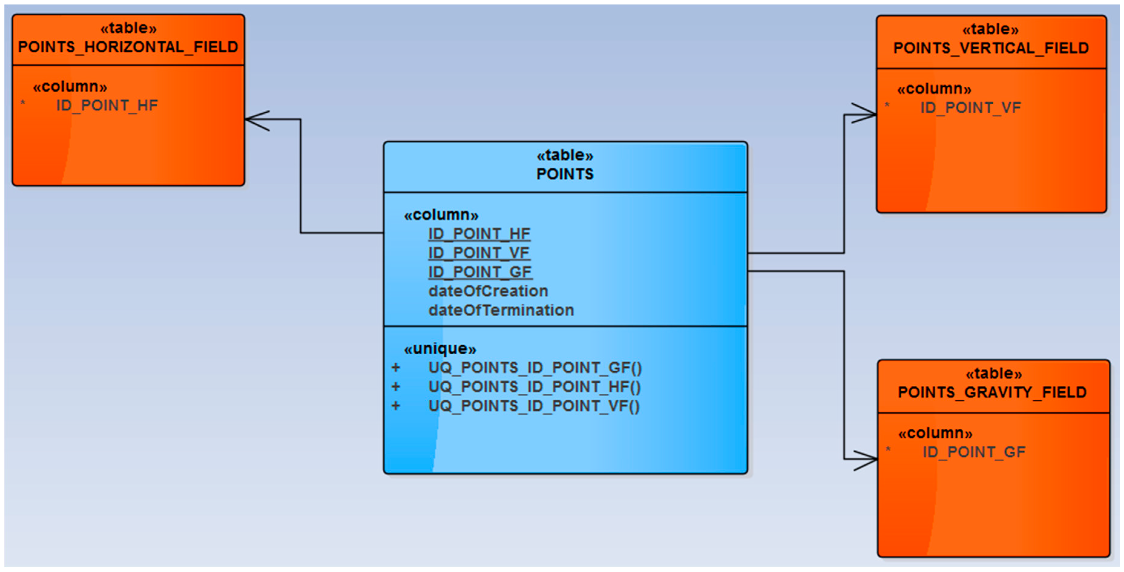
To ensure the integration of information about various kinds of geodetic point fields and enable the effective management of the data, the conceptual data model of the newly implemented spatial database has been enhanced for the joining table POINTS. This table serves as a glue between the parts of the data model dedicated to particular point fields (see
Figure 2) and enables an effective update of common information. The attributes of the table POINTS are as follows:
ID_POINT_HF,
ID_POINT_VF,
ID_POINT_GF,
dateOfCreation,
dateOfTermination.
The attribute ID_POINT_HF serves as a foreign key into the table POINTS_HORIZONTAL_FIELD. Similarly, the attributes ID_POINT_VF and ID_POINT_GF serve as the foreign keys into the table POINTS_VERTICAL_FIELD and POINTS_GRAVITY_FIELD respectively. If there are more identifiers stored in one raw of the POINTS table, then it means that the particular geodetic point belongs to the corresponding geodetic point fields.
The attribute dateOfCreation contains information about the date, when the record was created. If the validity of the record ended, then the time of termination is entered into the attribute dateOfTermination.
The triplet of attributes ID_POINT_HF, ID_POINT_VF and ID_POINT_GF serves as an unique key of the POINTS table. If the geodetic point belongs to the all geodetic fields (horizontal, vertical and gravitational), then there is only one record in the POINTS table. On principle, the data types of the used foreign keys could be different. Therefore, it is important that the used database technology supports this option. The next important thing is that one of the attributes forming the unique key can be NULL. A field with a NULL value is one that has been left blank during a record creation. Such a situation can happen when the geodetic point belongs to only one or two geodetic point fields.
It has to be said that in the proposed integrated database, each point still has the same identifier as it had in the previous system, so the continuity is ensured. These IDs are used in the joining POINTS table for reference purposes as described in the
Figure 2. Furthermore, no new coordinates are stored in the POINTS table. The coordinates of the points were loaded from the previous databases and now are stored in corresponding tables—for points belonging to the horizontal point field in the table POINTS_HORIZONTAL_FIELD, for points belonging to the vertical point field in the table POINTS_VERTICAL FIELD and for the points belonging to the gravitational field in the table POINTS_GRAVITY_FIELD. If the geodetic point belongs to more than one kind of geodetic field (e.g., horizontal and vertical), then the identifiers of this point are stored in the POINTS table in corresponding attributes, in this case attribute ID_POINT_HF (referencing the table POINTS_HORIZONTAL_FIELD) and attribute ID_POINT_VF (referencing the table VERTICAL_HORIZONTAL_FIELD).
Since the 1990s, the project of the revision of existing points using GPS technology has been realized. This was done for the whole territory of the Czech Republic with accuracy comparable to the one of trigonometric points. Further, the Land Survey Office operates the network of permanent GNSS (global navigation satellite systems) stations of known coordinates in binding reference system regularly spread at the whole territory of the Czech Republic. These permanent stations perform GPS observations, which are then provided to users in the form of corrections.
The full history of each point is kept. This allows one point to go to the past if required. Together with the date of creation and the date of termination also the dates of all updates are stored in the integrated spatial database of geodetic point fields. For each update, the identifier of the user who made the change is available.
7. The Prototype of the New Information System of Geodetic Point Fields
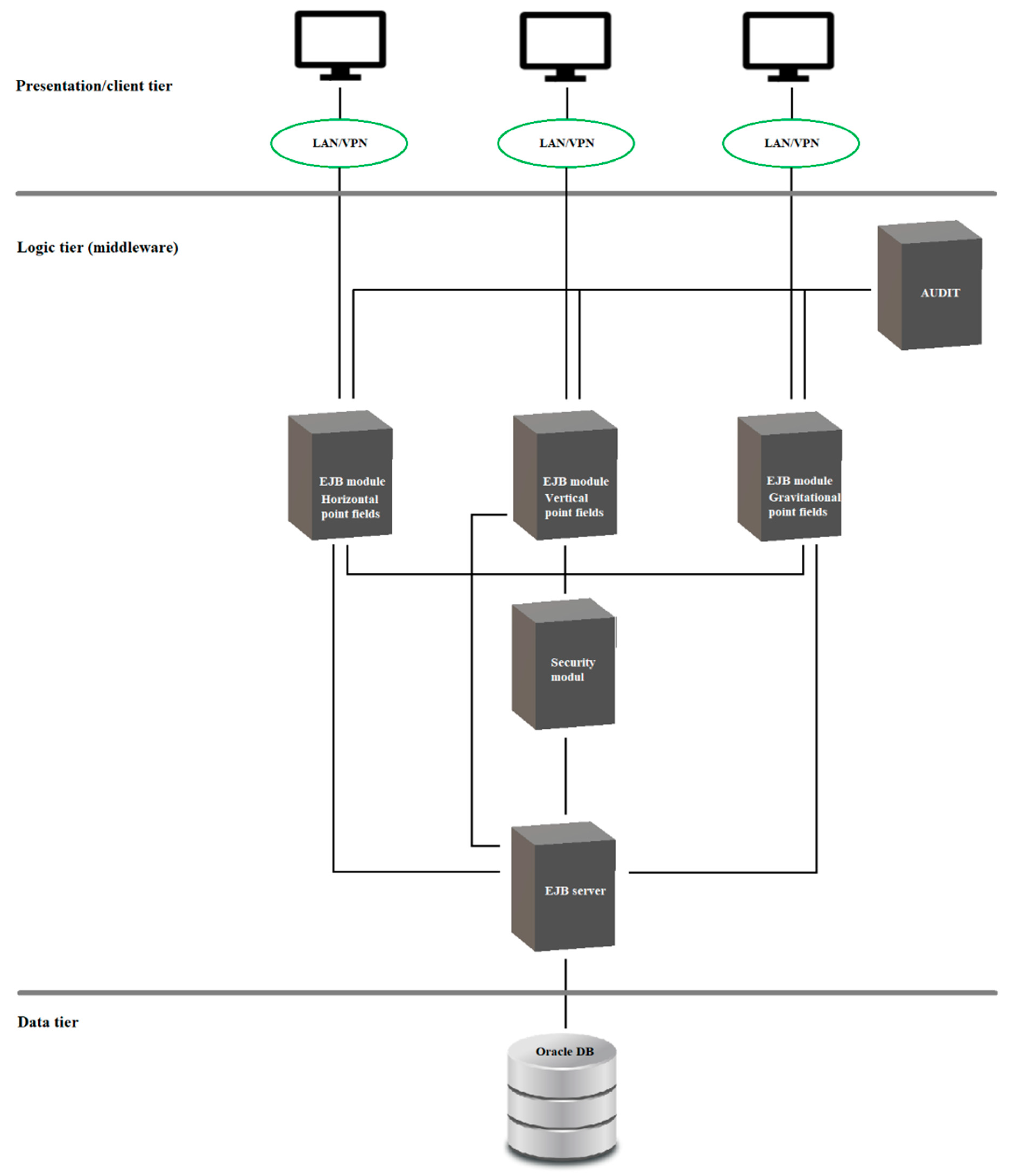
The prototype of the new information system of geodetic point fields has been developed in order to provide sufficient data management based on the new integrated spatial database. The prototype supports the necessary processes as they were supported by the older system and documented in corresponding system documentation. The proposed architecture reflects the requirements on the safe and controlled access to the integrated spatial database, which serves as a data tier within the three tier architecture of the Information system of geodetic point fields (see
Figure 3). The three tier architecture based on Oracle Spatial database has been applied e.g., by Zhao et al. [
25] and Li and Li [
26], where the middle tier was implemented using Oracle and ArcSDE technology, respectively. Comparing to these solutions, the prototype described here is less dependent on the application software of the third parties, which brings more flexibility when demands on new functions arise.
The thin client, which is a Java application using the JavaFX technology, can access the integrated database only through the Application Programming Interface (API). Each client application has its own corresponding Enterprise Java Bean (EJB) module in the middleware. The middleware consists of the modules with exactly defined interface to ensure a modularity and scalability of the system. The middleware is based on the Java EE platform and provides the API for access to the Oracle database and preparation of output data reports. Every access and operation defined in the API is controlled by the security module, which ensures authentication and authorization. The only EJB server module has an access to the database and contains the data model of all used tables. The other modules of the system use the simplified internal data model. To access the data, the object-relational mapping (ORM) with usage of Java Persistence API (JPA) is used. The unified access to the data is ensured by the QueryDSL library. The AUDIT module registers the requirements from the thin clients and creates the records about all activities.
The Information system of geodetic point fields (ISGPF) is a subsystem of the Information System of Land Surveying (ISLS). ISLS serves to land surveying activities, which are realized in the public interest. According to the Czech cyber-security law (Act No. 181/2014 Coll.), both ISLS and ISGPF are considered to be crucial information systems of public administration. Due to this fact, these systems have to implement certain cyber-security features. Security is an important topic in information systems and their applications, especially within the Internet environment [
27]. The threat of cyber-attacks is getting greater and due to the increasing use of computers, criminal activity has also changed from physical to cybernetic intrusion [
28]. Security and access for users is driven by the security module, which is a part of the middleware layer as expressed in
Figure 3. The procedures are defined in the security policy for logging in and out to prevent unauthorized access. Only a limited group of users is allowed to store and update the data in the database. Their identities are verified by logging into the domain within an internal network of the administrator of the database. After the user is logged in, they have access to the precisely defined functions based on the granted rights. Regarding the ISGPF and the new integrated spatial database of geodetic point fields, the following basic principles of safety management were applied:
A unique identification and authentication of the user. These operations have to proceed to any other user activity in the information system and have to ensure a protection of the credibility and integrity of the authentication information.
An optional management of access to the database objects based on access rights and identity of the user or his membership in the defined group (of users).
A continuous monitoring of activities, which could potentially affect the security of the information system and their recording by the AUDIT module.
As the Czech Republic is a member state of the European Union, it is important that the implemented prototype also enables to satisfy the requirements of the INSPIRE directive, i.e., it is possible to create data outputs in the coordinate systems recommended by INSPIRE (e.g., WGS-84) with regard to the accuracy of points of geodetic point fields. Furthermore, the prototype enables construction of geographical grids according to the INSPIRE data specifications [
30].
8. Conclusions
The existing architecture of the information system of geodetic point fields has been based on several subsystems with different databases. Such an approach restrains the further development and implementation of the new functionality. Due to the current demands on the functionality regarding the national and international spatial data infrastructures (e.g., INSPIRE), and the need to provide cyber-security, it was necessary to propose an integration and modernization of existing databases and propose and develop the new architecture and application software based on web technologies.
The optimized data model of the new integrated spatial database was proposed and successfully implemented. This allows for more efficient management of the information about the various kinds of geodetic point fields. In conformity with the development of international standards and initiatives, the integrated spatial database offers support for ETRS89 and European INSPIRE directive. Furthermore, to satisfy the legislative requirements, the prototype of the Information system of geodetic point fields has been developed. Being the crucial information system of public administration, the cyber-security features must be considered. The core security measure is, that the data tier, i.e., the integrated spatial database, can be accessed only through the defined API, after the unique identification and authentication of the user. The middleware, based on Java EE, then ensures the modularity and scalability of the system, which is important for further possible development of the system and dissemination and accessibility of the information about the geodetic point fields via modern web technologies.


