Abstract
The National Geographic Institute of Spain (IGN) carried out a Light Detection and Ranging (LiDAR) flight for the entire region of Andalusia between 2013 and 2014, which completed the general LiDAR acquisitions obtained for all of Spain since 2010. Recently, successive updates of orthoimages of Spain and Andalusia have also been acquired. This geographic documentation allows several applications for the aerial detection of archaeological sites. In recent years, numerous discoveries have been made in Spain, especially in non-built-up areas located outside urban enclaves. Less attention, however, has been paid to the use of this geographical information in historic cities because, apparently, they do not preserve their historical micro relief. This study analyses the city of Cordoba (southern Spain) by processing LiDAR data of the Plan Nacional de Ortofotografía Aérea (PNOA-LiDAR). Digital Surface Models (DSM) obtained for the entire city, in combination with geological and archaeological records, provide evidence of the geomorphological reconstruction of the city in ancient times. Using Cordoba as an example, the main purpose of this article is to highlight the fact that LiDAR data are also useful for the diachronic analysis of ancient urban structures buried some metres deep in current historic cities.
1. Introduction
GIS, Photogrammetric acquisitions, SFM mosaics or image-based methods are currently applied in digital mapping and modelling projects in historical centres or cultural heritage structures everywhere [1,2,3]. Laser scanning acquisitions are also currently used. However, less frequent are the remote sensing acquisitions applied to the detection of structures buried in historic centres.
In Spain, Light Detection and Ranging (LiDAR) data of the PNOA-LiDAR are a major resource for the detection of buried archaeological sites [4]. These spatial and cartographic databases of the IGN [5] have normally been used to verify structures already recorded by aerial photography. However, the detection of archaeological structures using LiDAR-PNOA data is less frequent.
The successful application of LiDAR in archaeology normally depends on the conservation of the historical micro relief in the ground (see, among others [6,7]). In an altered relief, traces of buried structures are barely visible. If the ancient relief is preserved, LiDAR pulses are of great utility for the detection and analysis of archaeological sites since they capture highly accurate three-dimensional geodata. LiDAR is especially recommended for the study of non-built-up, extra-urban areas where traces of buried archaeological sites can be effectively recovered. In recent years, a large number of fortified enclosures and prehistoric megalithic structures [8,9], Roman camps [10,11,12,13,14] and Roman constructions [15] have been detected in extra-urban areas of Spain through LiDAR-PNOA acquisitions.
The use of LiDAR data in geoarchaeological research has been particularly effective in historic landscapes. Most studies in this field have focused on human occupation in forest areas [16,17] or alluvial and coastal zones [18], among other cases. However, LiDAR is not normally used for the geoarchaeological reconstruction of urban centres in historic cities. Although the geoarchaeological literature on urban centres and their immediate surroundings is vast [19,20,21,22], the applied methodologies do not use LiDAR data.
The aim of this paper is to show that it is also possible to recover the relief and geomorphology of the Roman and medieval periods buried several metres deep in our historic cities. This aspect has usually not been considered in LiDAR data applications in the field of geoarchaeology, at least in Spain. The case of Cordoba shows that LiDAR data combined with geological and archaeological records can be useful for understanding the choice and development of pre-Roman and Roman building sites in the city. The data also permit us to evaluate the risk of flooding in the medieval period, because the city was expanded along flood zones in the eastern sector. Finally, LiDAR data in combination with geological maps of the area can also contribute to our knowledge of the geological landscape.
1.1. Geography and Geomorphology of Cordoba and the Guadalquivir River Valley
The territorial environment of the city of Cordoba is characterised by a horizontal relief and moderate slopes (approximately 170–100 m.a.s.l.), with a natural gradient towards the course of the Guadalquivir River. There are three stepped topographic areas of decreasing altitude: the base of the Sierra Morena mountains between the river and the high slopes; fluvial terraces, which are stepped landforms and constitute the main elements of the valley; and the strict alluvial plain and the current course of the Guadalquivir. As a result of these topographic features, this territory forms a natural longitudinal corridor, which is bordered to both the north and to the south by areas of higher relief: the Sierra Morena mountain range and the Campiña, an area of gently rolling hills with cultivatable land [23].
Based on the geomorphological evolution of space, this topography is associated with the geological layout produced by a series of tectonic, erosive and sedimentary events. The oldest materials are concentrated in the mountains of the north of Cordoba. These mountains form a wide fractured base raised by alpine thrusts, although the area is also geologically shaped by materials from the Cambrian period followed by volcanic contexts of the same period. A geological strip composed of calcarenites, limestones, sands and yellow silts formed the Messinian platform in the past. These deposits are related to the drastic eustatic descent of Mediterranean and Atlantic waters [24].
The Guadalquivir Valley forms a topographic and geological corridor associated with the most recent erosion and sedimentation processes mainly produced by the Guadalquivir River. A geomorphological layout comprised of alluvial fans of red clays, sands and conglomerates deposited throughout the Pleistocene is especially evident on the right bank of the Guadalquivir. In addition to these materials, there are discontinuous and asymmetrical Pleistocene fluvial terraces surrounding the river course which serve as the main drainage outlet of the river.
According to the maps (Figure 1) of the National Geological Institute of Spain (IGME), the current valley has three terraces or platforms with an unequal degree of conservation [21]. The oldest and highest quaternary terrace survives under the current city of Cordoba and is located in some fringes on the left bank of the river. The middle terrace, which corresponds to the middle Pleistocene deposits, occupies a large area on the river’s right bank. The third terrace, which is the lowest one, corresponds to the current course of the river. These terraced deposits have altitudes of between 170 and 100 m, a stepped relief, slopes lower than 3% and a composition formed by silts and sand.
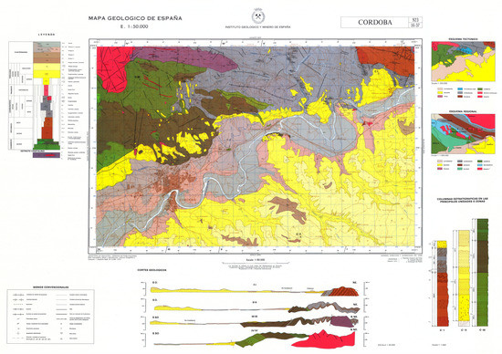
Figure 1.
Geological map of Spain, scale: 1:50,000. Geological Section of Cordoba and the central Guadalquivir Valley. In yellow, the Miocene mountains to the east and west of the river valley. In grey, the quaternary fluvial terraces of the Guadalquivir River. ©Instituto Geológico y Minero de España (IGME).
Water is one of the main resources of the territorial landscape of Cordoba. The surface waters of the area still form part of the Guadalquivir basin today. On the right side of the basin, numerous highly torrential rivers flow down from the Sierra Morena mountains. The impermeability of the materials on which these watercourses flow facilitates the direct drainage of the water into the Guadalquivir. There are also numerous fluvial courses under the city, which run between the quaternary terraces and gravel of unequal size [25].
All these elements form a stepped territory, with numerous watercourses and very benign materials for the cultivation of the river’s alluvial lands. This explains why Cordoba was chosen as a site for human settlement in ancient times and was the richest and most well-located city and capital of Andalusia for several millennia.
The LiDAR data acquisitions provide insight into this geological landscape and allow comparing the results of the acquisitions with information offered by the geological maps of the IGME.
1.2. Application of LiDar Data to the Ancient Geomorphology of Iberian and Roman Cordoba
The morphological study of Cordoba is of interest to understand the urban dynamics of the city. In fact, Cordoba sits upon three juxtaposed and superimposed cities with a chronology of more than three thousand years.
The earliest city was of pre-Roman origin and located in the western zone. This city was followed by the Roman foundation, which was located about 500 m east of the previous one. Finally, the late antique city and medieval Islamic city were located on top of the ancient Roman city. This is a very large historical site located in a compromised area of the Guadalquivir River, which was undoubtedly conditioned by the pre-existing orography (Figure 2).
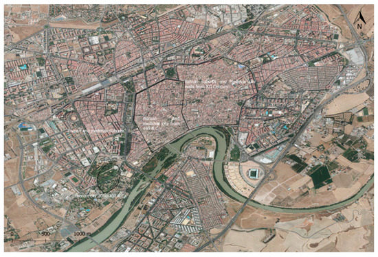
Figure 2.
The three historical settlements of Cordoba. The Iberian, Roman and medieval city and the new extension of the medieval city from the 12th century. Image: Orthoimage of 2016 acquired by IGN ©OrtoPNOA 2016 CC-BY 4.0 ign.es. Coordinates in the central axis of the image: 37°52′43″, 4°45′00″.
Traditionally, the ancient geomorphology of Cordoba has only been studied in a cursory manner, and archaeologists have normally had to rely on geological evidence to determine the general location and evolution of the city [26]. In this regard, it is common to find references in the literature to the quaternary terraces of the Guadalquivir River and to the streams that descend from the mountains as key factors that determined the location of pre-Roman and Roman Cordoba.
Recently, Liñán and Ruíz Bueno [27] examined the geomorphology of Cordoba based on a review of previous geological studies and archaeological knowledge of the city. This is valuable work, because it is the first time that that the city has been studied from a geoarchaeological methodological approach. Despite its value, the study has an important drawback: the topographic slopes and design of the terraces and river channels of the Roman Cordoba were not identified based on geotechnical surveys. As the authors recognise, the existing cartography was examined only visually to superimpose the city’s current topography on the archaeological and geological topography.
Considering the geomorphological background of Cordoba described above, and the almost total lack of geoarchaeological studies on ancient topography, this work aims to:
- Demonstrate the usefulness of LiDAR-PNOA data processing applied to the historic area of Cordoba occupied by the pre-Roman city, the Roman city and the medieval city. This could be replicated in other superimposed historic cities in Spain, because the open data sources of IGN are available for the entire national territory.
- Combine these results with the geomorphological background and archaeological knowledge of the city in order to trace the orographic history of the city’s urban development.
2. Materials and Methods
To analyse the geomorphology and historical and current geology of the city, the updated Spanish Geological Survey maps of the IGME [28] are a key resource. The National Geological Map (MAGNA) shows the nature and spatial distribution of the materials (rocks and sediments), as well as the geometric relations between the different cartographic units. In this case, a geological cartographic unit comprises a group of one or several lithologies within a common age interval that is represented on the map. Sheet number 923 shows the territory of the central Guadalquivir River Valley and of Cordoba.
There is a large body of literature on the archaeological geomorphology of Cordoba. Thanks to some archaeological excavations carried out in the 1970s, the location, extension and chronology of the Iberian city are well-known [29,30,31]. The urban development of both the Roman and medieval Cordoba is even better known given the substantive data on the temporal sequence, urban organisation and most of the buildings.
It is of interest to conduct a geomorphological analysis of a city in which several archaeological research projects have been conducted (some of them under the direction of the author of this article). Although it is impossible to make reference to all of archaeological research activity here, several archaeological resources that justify the sites studied in this research will be cited in the discussion of this work. For a general overview of the research being conducted in this field in Cordoba, see the website of the Arqueocordoba research project which contains all the studies published to date on ancient and medieval Cordoba [32].
The LiDAR-PNOA acquisitions processed in this work have been acquired by IGN and are available on the Centro Nacional de Información Geográfica (CNIG) website [33]. Clouds of points have been acquired with a density of 0.5 points/m2 and an altimeter accuracy of about ±20 cm root mean square error (RMSE). The points have been automatically classified by the CNIG. The study area is zone 30 (6° W-0° W Northern Hemisphere), the projection is UTM and the coordinate system is ETRS89. The altitudes are orthometric. The format of LiDAR data files is Log ASCII Standard (LAS) or the compressed version (LAZ). Data are accompanied by some auxiliary files that include a decompression tool and visualisation of the LAZ and LAS files, metadata, specifications and a file of acquisition dates.
Global Mapper version 18.1 was used to process the LiDAR data. The selected LiDAR pulses correspond exclusively to ground levels, never to buildings. The DSM was generated and analysed by means of different hillshade algorithms. Hillshading with colour ramps is the most effective way to analyse the geomorphology of Cordoba. Vertical exaggerations in 3D view have at most two points.
The extraction of the slope and contour lines presented in this work have been processed in QGIS v.3.4.3 from an exported Grid asc. file generated first from Global Mapper 18.1. There is a difference of 10 m.a.s.l. between the slope lines. The hydrographic basin of the Iberian city of Cordoba was analysed from the DSM and also processed with Global Mapper 18.1 [34].
When interpreting the DSM, it is very difficult to discriminate points that correspond to modern constructions from those of ancient ground traces. This is a less difficult task when studying the Iberian Cordoba because it is a public garden today and the ancient micro relief is well preserved. On the original morphology of the hill, where this city was built, there is only a thin layer of grass, thus enabling a fairly reliable analysis based on the surface points.
Moreover, the Roman and medieval city is located under the current urban centre of the modern Cordoba. In order to understand the layout of the ancient city, we have resorted only to the LiDAR points that correspond to the development of the quaternary terraces of the Guadalquivir, the line of the Roman city walls and, finally, the different slopes of its major constructions, such as the ancient Roman theatre. The investigation of the ancient orography of the historic city is possible only in general lines. This method is not valid for single, small and mid-sized buildings or ancient streets.
The relationship between the quaternary terraces and the anomalies in the slopes of the southern sector of the Roman walled enclosure reveals how the lower quaternary terrace in this part of the ancient riverbed was modified.
In order to compare the interpretations of the LiDAR data to the archaeological records of the city, we have used the Geographical Information System of Archaeological Excavations of Cordoba (SIGEAC) [35]. The SIGEAC contains data on all the archaeological excavations carried out in the city, as well as the recovered historical periods, the related literature and the archaeological materials identified in each of the excavations.
This GIS allows combining the archaeological reality with the geological and geoarchaeological situation of the city. It has been especially useful to analyse changes between the current and ancient course of the Guadalquivir River, as discussed below.
3. Results
3.1. Geomorphological Layout of the Guadalquivir River Valley in Cordoba
The first DSM (Figure 3) shows the river’s central fluvial zone and its meanders that practically flooded the entire pre-Roman and Roman areas surrounding Cordoba. The lower quaternary terrace of the Guadalquivir [36,37,38,39]—Q3T in the IGME geological map IGME (see Figure 1)—is also visible on both banks of the river (red arrows) at an elevation of 100 to 200 m.a.s.l.
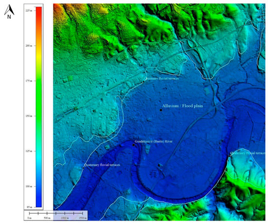
Figure 3.
Territorial landscape of Cordoba. Mountains (North: Sierra Morena), quaternary fluvial terraces and alluvium of the Guadalquivir River. DSM processed from LAS files. The ©PNOA-LiDAR 2016 CC-BY 4.0 ign.es files were processed with the Global Mapper 18.1 colour ramp shader hillshade by Antonio Monterroso-Checa. Coordinates in the central axis of the image: 37°52′43″, 4°45′00″.
This DSM shows the whole quaternary layout of the territory. For that reason, the city’s current urban development is not a barrier to research on the ancient geomorphological layout of Cordoba: geological maps and LiDAR acquisitions provide the same information. However, the DSM can identify some contour lines of the quaternary terraces (red arrows) more precisely than geological maps, as these maps are usually of a very large scale (1:50,000 m). For the first time in Cordoba, this DSM shows the quaternary layout of the territory together with the current city and not only its geological aspect, as is usually shown in geological maps.
3.2. Geomorphological Reconstruction of the Iberian Cordoba Site
The second DSM (Figure 4a–c) captures the site of the Iberian Cordoba. In the hill where the ancient settlement of pre-Roman Cordoba was excavated, the DSM has identified a high plateau formed by two hills situated between two levels of a lower quaternary terrace. The highest area of the first hill has a flat surface that must be associated with the walled enclosure. The hill has an extension of around 14 ha. To the NW of these hills, the terrain descends until connecting with another slope of the second quaternary terrace. To the SE a cliff appears to separate the Iberian city from an ancient river course near the current channel. In fact, it seems that in Iberian times, and surely before, the Guadalquivir River was in contact with the cliffs where the Iberian city of Cordoba was built. Hypothetically, this DSM seems to show a paleo river channel between the current channel and the Iberian hill.
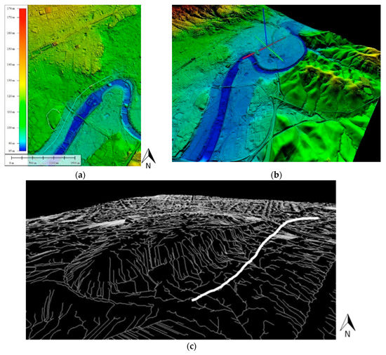
Figure 4.
(a,b): Site of pre-Roman Cordoba. An abrupt cliff separates the Iberian city and the old Guadalquivir riverbed. The zone of the hypothetical ancient channel shown in Figure 4c is marked with white lines. DEM from LAS. files. The ©PNOA-LiDAR 2016 CC-BY 4.0 ign.es files were processed with the Global Mapper 18.1 atlas shader hillshade and the 3D model was developed by Antonio Monterroso-Checa. Vertical exaggeration in 3D model: 2.75. Coordinates in the central axis of the image: 37°52′20″, 4°47′22″. (c) Settlement and cliff of Iberian Cordoba. The 3D analysis of hydrographic basins with +2.75 points of vertical exaggeration shows the riverbed slopes in the direction of the ancient Guadalquivir River channel (white line). Image generated from LAS files. The ©PNOA-LiDAR 2016 CC-BY 4.0 ign.es files were processed with Global Mapper 18.1 by Antonio Monterroso-Checa.
3.3. Geomorphological Reconstruction of the Roman Cordoba Site
The DSM of the first ancient Roman settlement (Figure 5) shows an enclosure adapted to another residual hill located between the base of the mountains and the left bank of the Guadalquivir. This hill is in the same quaternary terrace and was the site where the new Roman city was built 500 m away from the previous one. The city had a surface area of around 50 ha. and was located near the mountains in contact with the river. According to the DSM, the SE sector of the city again bordered directly on the hypothetical ancient channel of the Guadalquivir. The DSM shows a perfectly continuous line that connects the cliff of the Iberian city to the moderate slopes in the south of the Roman city. Like the Iberian city, the S limit of the Roman city must also have coexisted with the ancient riverbed, especially during flood seasons.
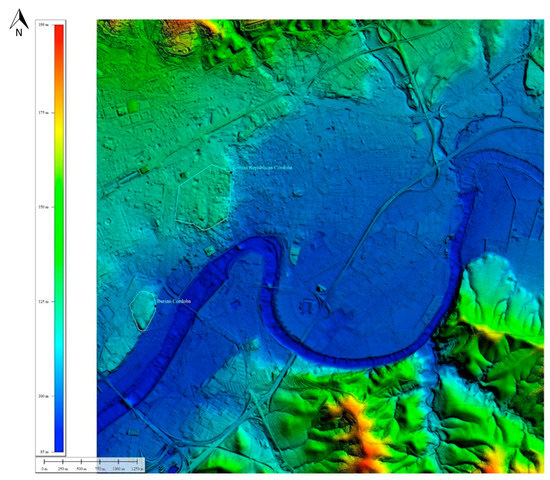
Figure 5.
The settlement and enclosures of the pre-Roman and first Roman Cordoba are circled in white. DSM generated from LAS files. The ©PNOA-LiDAR 2016 CC-BY 4.0 ign.es files were processed with the Global Mapper 18.1 colour ramp shader hillshade by Antonio Monterroso-Checa. Coordinates in the central axis of the image: 37°52′43″, 4°45′00″.
3.4. Geomorphological Reconstruction of a lost Hypothetical Meander of the Guadalquivir
Due to the connection between the cliff of the Iberian city and between the first Roman city and the border of the Guadalquivir River, it is important to examine the current layout of its meander. The continuation of the old river channel towards the NE and the shape of a sloped curve approximately parallel to the current meander can be verified by observing the line of the quaternary terrace where the two cities were located. Hypothetically, this could be a clogged meander corresponding to the paleo river channel.
In order to verify this geomorphological situation shown by the DSM, we have reviewed the m.a.s.l. elevations and the slope of this hypothetical paleo meander at several points. In the section of the quaternary terrace from the Iberian city to the Roman city, the cliff of the old river channel ranges from 101.40 to 104 m.a.s.l. In the Roman city, the old quaternary terrace rises to an elevation of 110.46 m.a.s.l. The profile of the old channel drops again to 102.31 m.a.s.l. in the western sector. These slopes show that the old river course remained constant on both sides of the elevation where the Roman settlement was located (Figure 6a,b). Likewise, the heights of the slope of the paleo channel and the meander correspond on both sides of the Roman city. The elevations descend from 104.45/103.20 to 96.77/97.85–96.54 m.a.s.l. Therefore, there is a uniform drop of about 7–8 m, which suggests the existence of the paleo channel and the old meander corresponding to this channel.
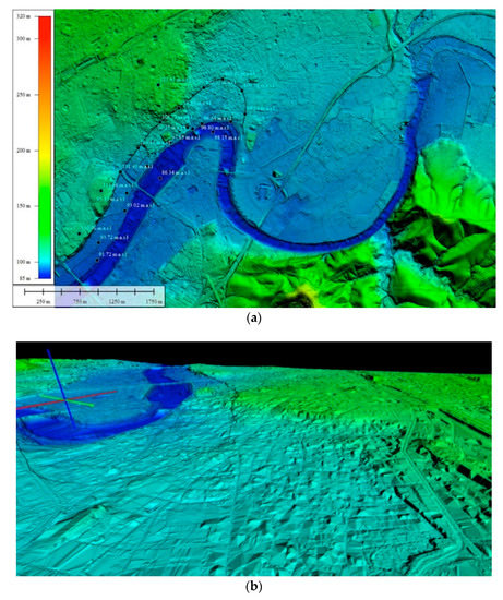
Figure 6.
(a,b): A. Elevations, slopes and layout of the ancient paleo channel and the hypothetical paleo meander of the Guadalquivir River. B. 3D model (vertical exaggeration: 2.75). The building that stands out in the ancient paleo riverbed of the Guadalquivir is the Great Mosque of Cordoba (S.X a. C). It is not available to delete the LiDAR points from the general point cloud acquired by PNOA-LIDAR. DSM generated from LAS files. The ©PNOA-LiDAR 2016 CC-BY 4.0 ign.es files were processed with the Global Mapper 18.1 colour ramp shader hillshade and the 3D model was developed by Antonio Monterroso-Checa. Coordinates in the central axis of the image: 37°51′40″, 4°49′00″.
Logically, the current meander cannot correspond to the old channel since they are not of the same position or height.
3.5. Occupation of the Old Riverbed by the Enlargement of the Roman City
The LiDAR data (Figure 7a) seem to indicate that this sector of the imperial city was erected on the old bed of the Guadalquivir River. Likewise, as mentioned, this new part of the Roman city is higher than the E and W sectors located outside its wall. This is an anomaly since the old riverbed should have a constant altimetry, and that is not the case.
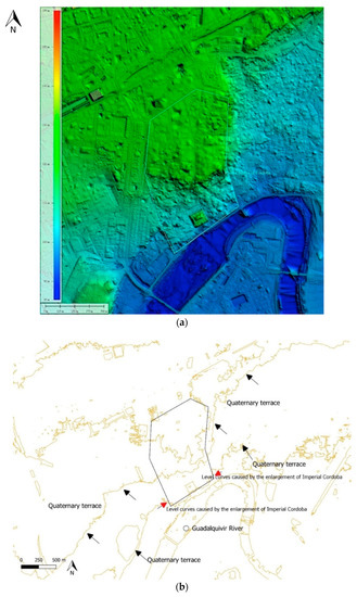
Figure 7.
(a): Enlargement of Imperial Roman Cordoba (with the site of the Roman theatre) generated from the LAS files. The ©PNOA-LiDAR 2016 CC-BY 4.0 ign.es files were processed with the Global Mapper 18.1 colour ramp hillshader by Antonio Monterroso-Checa. (b): The extraction of the slope lines shows how the new Roman city occupied the ancient zone and floodable area of the river. The contour lines indicate the southern limits of the walls of this enlargement; the quaternary terrace has been completely altered in this point by the construction of this new Roman city. Slope lines were extracted with QGIS 3.4.3. by Antonio Monterroso-Checa.
We have taken the elevations of two LiDAR points corresponding to the ground on both sides of the Roman enclosure. In the western sector there is a difference of about four metres between the exterior and interior of the Roman city. In the eastern sector, there is a difference of almost three metres in the slope. Therefore, it seems clear that the new Roman city was built in a previous fluvial zone (Figure 7b). The slope lines indicate that the south part of this enlargement occupied the ancient channel of the Guadalquivir as shown in Figure 5 and Figure 6.
This sector of the city was built in the riverbed and elevated with respect to other sector externals to the city walls. Therefore, the Romans had to fill in the river to protect the city from the water. This artificial elevation can be clearly seen in the DSM. The Romans had to deal with the abrupt level and the soil moisture in much of this extension. The DSM also shows that there were two geographically differentiated sectors in this southern area. The SE sector is higher and seems to form its own enclosure in which the theatre was built taking advantage of the slope.
4. Discussion
Methodologically, the most challenging task in recovering the ancient urban structures of Cordoba is the selection of LiDAR points in what is today a very built-up city. This process is necessary to draw relevant conclusions regarding the morphology of the ancient city. In this case, we have filtered and used only LiDAR points at ground level. This has ensured a reliable analysis, since the points have revealed the paleo morphology of the city, in line with the geology and archaeology literature.
The use of LiDAR data processing has also permitted some irregularities of the quaternary terraces to be identified in the centre of the city, thus providing more detailed geological information than geological maps.
Archaeologically, the results provide accurate information about the location of the city of Cordoba in a fluvial environment situated between two rugged and mountainous environments on both sides of the Guadalquivir River Valley.
4.1. The Location of Iberian Cordoba (Approx. 300–100 B.C.)
The first city of Cordoba was located in what is Cruz Conde Park today. Several stratigraphic excavations have been carried out in this site which provide a chronology dating to 3000–2500 B.C. However, there is evidence of more consistent archaeological remains from the Late Bronze Age (around 800–700 B.C.) associated with a town whose main activity was metallurgy. This town has been perfectly recovered by the DSM.
The results of the DSM are less conclusive with regard to the hypothetical second perimeter to the W, an area which was not necessarily walled and seems to have been orographically juxtaposed to the previous one. Together, the two enclosures span an area of 34 ha. This second sector must correspond to the outer part of the city where industrial areas and nearby agricultural lands, among others, were located. Archaeological remains from the pre-Roman era have also been documented in this sector [40]. However, the area has been strongly modified in the present city. The DSM analyses were unable to recover the ancient layout of this second sector of the Iberian city.
4.2. The Location of Cordoba in the Roman Republic Period (169–168 B.C.)
The later Roman city built by Marcus Claudius Marcellus in 169–168 B.C. is located about 500 m west of the old Iberian Cordoba. This Roman city was founded so that Rome could hold control over the middle valley of the Guadalquivir and the rich mines in the mountains of Cordoba, which had been previously exploited by the Turdetan (Iberian) oligarchies [41].
This historical reason explains the intention but not the place chosen to build the new Roman Cordoba. The DSM has verified the continuity to the E of the same terrace of the Guadalquivir on which the previous Iberian city had been built. Evidence of several floods, or fluvial zones, have also been documented in this sector [42].
However, the LiDAR data acquisitions have not recovered any large architectural ensembles in this Roman Cordoba and the DSM has only detected the lines of the city walls. Ancient walls were superimposed at the borders of the hill where the Roman city was built. These borders mark the second quaternary terrace of the Guadalquivir and have a strong morphological form as the LiDAR pulses have shown.
A section of the wall of this first Roman city was discovered in the excavations of the old Roman theatre. Indeed, these walls follow the layout of the remains of the second quaternary terrace next to which some small structures that may be related to a type of funerary monument have been found [43,44].
4.3. A Lost Meander of the Hypothetically Recovered River
The DSM shows a continuous river course linking the Iberian city and the Roman city. A bit further to the north, there seems to be a curve that may correspond to the meander of this old river course.
In the excavations carried out in this sector, it has been difficult to recover Roman remains, as they are extremely deep and buried under an enormous amount of silty clay. In fact, in almost all the excavations, the depth of the Roman stratum has not been reached [45,46,47,48]. Only one archaeological excavation recovered the Roman level in a clear context of sand and silt from the floodwaters of the river [49]. The beginning of the stratigraphic sequence started in Roman times with the discovery of a pit for the extraction of clays, possibly used to manufacture pottery. In this sector, flood seasons have also been documented even during the Roman period [50,51].
Therefore, the layout identified by the DSM corresponds to an archaeological site full of sands, silts and prone to flooding, thus suggesting the existence of a paleo meander. However, this proposal can only be confirmed by geotechnical tests.
4.4. Results on the Enlargement of Cordoba in the Roman Imperial period (45 B.C.–100. A.C.)
From the year 45 B.C., the old Roman city was extended towards the S and grew to 75 ha. This expansion entailed the organisation of streets and neighbourhoods in a new street grid. The theatre was built in the most eastern corner of the area. This southern part of the city was not walled until the last quarter of the 1st century A.D. The interesting question in terms of geomorphology and construction is: how was that extension built in an old zone of influence of the river?
The theatre is precisely the only testimony to validate our analysis because it was built directly on the boundary of a quaternary terrace of the river. In the excavations of the theatre, even the geological marls on which this quaternary rock sits were recovered. In some areas, huge compartments of water from the river channel are preserved under the quaternary rock; which is still fed by the mountain springs (Figure 8) [52].
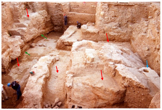
Figure 8.
Ima cavea (lower seats) of the Roman theatre of Cordoba excavated in the quaternary terrace of the Guadalquivir River. Blue arrows indicate the ancient marble seats of theatre. Red arrows indicate the quaternary terrace. Green arrows indicate geological marls. ©Antonio Monterroso-Checa.
The ima cavea and the orchestra are completely excavated on the slopes of the old river bed. Under the cavea of the theatre, accumulations of water belonging to the flood level of the river are currently preserved. The rest of the constructions in this sector of the city did not reach the level of the marls and therefore did not have to modify this geological cliff. Quaternary terrace was entirely covered by the new enlargement of the Roman city.
5. Conclusions
Research on the ancient geomorphology of a historic city is a challenging undertaking. Firstly, it is difficult to recover a considerable extension of the subsoil. Secondly, it is difficult to conduct geotechnical tests in the most geologically interesting sites.
LiDAR data help to overcome these limitations. However, it is important to recognise the shortcomings of such applications. Only the return pulses that refer to the ground are valid in this type of studies. All ground is not valid, only those areas where old traces of the buried city remain. In this work, these difficulties have been taken into account and only cases where these two rules are satisfied have been proposed. However, the results are satisfactory.
- The shape of the quaternary terraces in the urban centre of the city has been specified and a three-dimensional image has been obtained in a level of detail that geological maps are unable to provide.
- The geomorphological and volumetric layout of the hill where the Iberian Cordoba settlement was located has been identified.
- An old course of the Guadalquivir River has been identified, the limits of which were located in the Iberian city and the Roman city.
- Hypothetically, the presence of an old meander of the river, which is currently clogged, has been proposed.
The main conclusion is that historic cities such as Cordoba, which are located in a defined geological context, can be studied from LiDAR acquisitions. This work is perfectly replicable in all the historic cities of Spain where geological and archaeological research is currently being carried out, as is the case of Cordoba.
Funding
This research has received funding of HUM 882 Research Group of the University of Cordoba.
Acknowledgments
The author is grateful to the anonymous reviewers for their suggestions, which have greatly improved the structure and content of the paper. He would also like to thank Martha Gaustad for revising the English.
Conflicts of Interest
The authors declare no conflict of interest.
References
- Hatzopoulos, J.N.; Stefanakis, D.; Georgopoulos, A.; Tapinaki, S.; Volonakis, P.; Liritzis, I. Use of various surveying technologies to 3D digital mapping and modelling of cultural heritage structures for maintenance and restoration purposes: The Tholos in Delphi. Mediterr. Archaeol. Archaeom. 2017, 17, 311–336. [Google Scholar] [CrossRef]
- Cihan Altuntas, S.; Süleyman, K. Image based methods for surveying heritage of masonry arch bridge with the example of dokuzunhan in Konya, Turkey. Sci. Cult. 2017, 3, 13–20. [Google Scholar] [CrossRef]
- Kaimaris, D. Ancient theaters in greece and the contribution of geoinformatics to their macroscopic constructional features. Sci. Cult. 2018, 4, 9–25. [Google Scholar] [CrossRef]
- Adara López-López, A.; Cerrillo Cuenca, E. Arqueología Aérea y Fuentes de Datos Libres. Posibilidades y Lte. 2016, 1, 181–193, (LiDAR-PNOA for archaeology of and other Spanish databases). [Google Scholar]
- Instituto Geográfico Nacional. Available online: www.ign.es (accessed on 7 May 2019).
- Chase, A.S.Z.; Chase, D.Z.; Chase, A.F. LiDAR for Archaeological Research and the Study of Historical Landscapes. In Sensing the Past; Masini, N., Soldovieri, F., Eds.; Geotechnologies and the Environment 16; Springer: Cham, Switzerland, 2017; pp. 89–100. [Google Scholar] [CrossRef]
- Masini, N.; Coluzzi, R.; Lasaponara, R. On the Airborne Lidar Contribution in Archaeology: From Site Identification to Landscape Investigation, Laser Scanning, Theory and Applications. In Laser Scanning, Theory and Applications; Wang, C.-C., Ed.; IntechOpen: Rijeka, Croatia, 2011; pp. 263–290. [Google Scholar] [CrossRef]
- Carrero-Pazos, M.; Vilas Estévez, B.; Romaní Fariña, E.; Abel Rodríguez Casal, A. La necrópolis del Monte de Santa Mariña revisitada: Aportaciones del Lidar aéreo para la cartografía megalítica de Galicia. Gallaecia 2015, 33, 39–57. [Google Scholar] [CrossRef][Green Version]
- Cerrillo Cuenca, E. An approach to the automatic surveying of prehistoric barrows through LiDAR. Quat. Int. 2017, 435, 135–145. [Google Scholar] [CrossRef]
- Costa-García, J.M.; Casal García, R. Fotografía aérea histórica, satelital moderna y lidar aéreo en algunos recintos militares romanos de Castilla y León. Portvgalia 2015, 36, 143–158. [Google Scholar]
- Costa García, J.M. Presencia militar romana en La Chana (Castrocalbón, León). Nailos EstudiosInterdisciplinares de Arqueología 2016, 3, 47–85. [Google Scholar]
- Berrocal-Rangel, L.; Paniego Díaz, P.; Ruano, L.; Manglano Valcárcel, G.R. Aplicaciones LiDAR a la topografía arqueológica: El Castro de Irueña (Fuenteguinaldo, Salamanca). Cuadernos de Prehistoria y Arqueología Universidad Autónoma de Madrid 2017, 43, 195–215. [Google Scholar] [CrossRef]
- Blanco-Rotea, R.; Güimil-Fariña, A.; Mañana-Borrazás, P.; Fonte, J. Using airborne laser scanning and historical aerial photos to identify fortifications in the Minho Valley, Northwest Iberian Peninsula. In Three Dimensions of Archaeology, Proceedings of the XVII UISPP World Congress, Burgos, Spain, 1–7 September 2014; Kamermans, H., de Neef, W., Piccoli, C., Posluschny, A.G., Scopigno, R., Eds.; Volume 7/Sessions A4b and A12; Archaeopress: Oxford, UK, 2016; pp. 111–120. [Google Scholar]
- Cordero Ruiz, T.; Cerrillo Cuenca, E.; Pereira, C. Detección de un nuevo campamento romano en las inmediaciones de Mérida mediante tecnología LiDAR. Saguntum 2017, 49, 197–201. [Google Scholar] [CrossRef]
- Monterroso Checa, A. Remote Sensing and Archaeology from Spanish LiDAR PNOA: Identifying the roman the Amphitheatre of the roman city of Torreparedones. Mediterr. Archaeol. Archaeom. 2017, 1, 22–56. [Google Scholar] [CrossRef]
- Devereux, B.J.; Amable, G.S.; Crow, P.; Cliff, A.D. The potential of airborne LiDAR for detection of archaeological features under woodland canopies. Antiquity 2005, 79, 648–660. [Google Scholar] [CrossRef]
- Sittler, B. Revealing Historical Landscapes by Using Airborne Laser Scanning. A 3-D Modell of Ridge and Furrow in Forests near Rastatt (Germany). In Proceedings of Natscan, Laser-Scanners for Forest and Landscape Assessment—Instruments, Processing Methods and Applications, Freiburg, Germany, 3–6 October 2004; Thies, M., Koch, B., Spiecker, H., Weinacker, H., Eds.; International Archives of Photogrammetry and Remote Sensing; Volume XXXVI, Part 8/W2; International Society for Photogrammetry and Remote Sensing: Freiburg, Germany, 2004; pp. 258–261. [Google Scholar]
- Bini, M.; Fabiani, F.; Pappalardo, M.; Schuldenrein, J. Special issue of Geoarchaeology: Urban geoarchaeology in the Mediterranean Basin. Geoarchaeology 2018, 33, 3–12. [Google Scholar] [CrossRef]
- Fontana, A.; Ronchi, L.; Rossato, S.; Mozzi, P. Lidar-derived dems for geoarchaeological investigations in alluvial and coastal plains. Alp. Mediterr. Quat. 2018, 31, 209–212. [Google Scholar]
- Cremaschi, M.; Storchi, P.; Perego, A. Geoarchaeology in urban context: The town of Reggio Emilia and river dynamics during the last two millennia in Northern Italy. Geoarchaeology 2018, 33, 52–66. [Google Scholar] [CrossRef]
- Butzer, K.W.; Butzer, E.; Love, S. Urban geoarchaeology and environmental history at the Lost City of the Pyramids, Giza: Synthesis and review. J. Archaeol. Sci. 2013, 40, 3340–3366. [Google Scholar] [CrossRef]
- Amato, V.; Ciarcia, S.; Rossi, A.; Santoriello, A. The urban geoarchaeology of Benevento (Southern Italy): A tool for the evaluation of archaeological potential. Geoarchaeology 2018, 33, 100–111. [Google Scholar] [CrossRef]
- Torres Márquez, M. Paisajes del Valle medio del Guadalquivir cordobés: Funcionalidad y cambios. Revista de Estudios Regionales 2013, 96, 135–180. [Google Scholar]
- Ramírez Copeiro, J.; Castellò Montorí, R.; Armengot de Pedro, J. Mapa Geológico de la Hoja nº 923 (Córdoba). Mapa Geológico de España a Escala 1:50,000 Segunda Serie (MAGNA). 1973, Volume 923, pp. 16–37. Available online: http://info.igme.es/cartografiadigital/datos/magna50/memorias/MMagna0923.pdf (accessed on 7 May 2019).
- Martínez del Olmo, C.; Riaza Molina, C.; Torrescusa Villaverde, S. Descenso eustáticomessiniense en una cuenca atlántica. El cañón submarino del río Guadalquivir (SO de España) Geogaceta 1996, 20, 138–141. [Google Scholar]
- Ruiz Lara, D.; Ortiz, R.; Carmona, S.; Soriano, P. El medio físico. In El Anfiteatro Romano de Córdoba y su Entorno Urbano; Vaquerizo, D., Murillo, J., Eds.; Análisis arqueológico, vol. I. (ss. I-XIII d.C.); Junta de Andalucía: Sevilla, España, 2010; pp. 33–42. [Google Scholar]
- Liñán Guijarro, E.; Ruiz Bueno, M. Las terrazas fluviales de Córdoba y su influencia en el emplazamiento de la ciudad en época prerromana y romana. Cuaternario y Geomorfología 2018, 32, 9–22. [Google Scholar] [CrossRef]
- Instituto Geológico y Minero de España. Available online: www.igme.es (accessed on 7 May 2019).
- León Pastor, E. La Secuencia Cultural de la Corduba Prerromana a Través de sus Complejos Cerámicos; Universidad de Córdoba: Córdoba, Spain, 2007. [Google Scholar]
- Murillo, J.F. Nuevos trabajos arqueológicos en Colina de los Quemados: El sector del teatro de la Axarquía. (Parque Cruz Conde, Córdoba). Anuario Arqueológico de Andalucía 1992, 3, 188–199. [Google Scholar]
- Murillo, J.F.; Vaquerizo, D. Corduba prerromana. In Colonia Patricia Corduba, una reflexión arqueológica; León, P., Ed.; Universidad de Córdoba: Córdoba, Spain, 1996; pp. 37–47. [Google Scholar]
- Arqueocórdoba. Available online: http://www.arqueocordoba.com/recursos/bibliografia/ (accessed on 7 May 2019).
- Centro de Descargas CNIG. Available online: http://centrodedescargas.cnig.es/CentroDescargas/index.jsp (accessed on 7 May 2019).
- Mihaela, P.; Codruţa, B.M.; Gabriel, E.; Daniela, P. Hydrographic Basins Analysis Using Digital Terrain Modelling. IOP Conf. Ser. Mater. Sci. Eng. 2017, 245, 062034. [Google Scholar] [CrossRef]
- Sistema de Información Geográfica de Excavaciones Arqueológicas de Córdoba (SIGEAC). Available online: http://www.arqueocordoba.com/sigeac/ (accessed on 7 May 2019).
- Uribelarrea, D.; Benito, G. Fluvial changes of the Guadalquivir River during the Holocene in Córdoba (Southern Spain). Geomorphology 2008, 100, 14–31. [Google Scholar] [CrossRef]
- Núñez Granados, M.A.; Recio Espejo, J.M. Tributary Alluvial Fan–Response to Base-level Fall by Axial Fluvial Incision: A Case in the Guadalquivir Valley (Córdoba, Spain). Open Geogr. J. 2014, 6, 9–12. [Google Scholar] [CrossRef][Green Version]
- Baena Escudero, R.; Díaz del Olmo, F. Cuaternario Aluvial de la Depresión del Guadalquivir: Episodios geomorfológicos y cronología paleomagnética. Geogaceta 1994, 5, 102–104. [Google Scholar]
- Rodríguez Ramírez, A.; Cáceres, J.M.; Rodríguez, J.; Clemente, L.; Cantano, M. Geomorfología de las terrazas fluviales del tramo bajo del Guadalquivir. Implicaciones evolutivas. Geogaceta 1997, 21, 183–186. [Google Scholar]
- Godoy Delgado, F.; Morena López, J.A. Prospección Arqueológica Superficial de Urgencia en los terrenos afectados por la red de distribución de gas natural a industrias de Córdoba. Anuario Arqueológico de Andalucía 1989, 3, 119–126. [Google Scholar]
- Ventura, A.; León, P.; Márquez, C. Roman Córdoba in the light of recent archaeological research. In The Archeology of Early Roman Baetica; Keay, S., Ed.; Supplementary Series; JRA: Portsmouth, NH, USA, 1998; Volume 29, pp. 87–107. [Google Scholar]
- Carrasco Gómez, I.; Murillo Redondo, J.F.; Rodero Pérez, S.; González Virseda, M.; Garriguet Mata, J.A. Informe-memoria de la I.A.U. en el Paseo de la Ribera (1999–2001). I. Sector de la Puerta del Puente. Anuario Arqueológico de Andalucía 2000, 3, 283–298. [Google Scholar]
- Ventura, A.; y Monterroso-Checa, A. Estudio sucinto de la campaña de excavación 1998–2000 en el teatro romano de Córdoba: La terraza media oriental. Anuario Arqueológico de Andalucía 2000, 3, 427–446. [Google Scholar]
- Courault, C. Les Remparts de Cordue. Une Investigation Archéologique Depuis l’Antiquité Jusqu’à L’époque Médiévale. Ph.D. Thesis, University of Córdoba, Córdoba, Spain, 2014. [Google Scholar]
- Liébana Sánchez, M. Actividad Arqueológica Preventiva en el solar sito en la c/ Paseo de la Ribera nº 19, Córdoba. Anuario Arqueológico de Andalucía 2006, 3, 1192–1199. [Google Scholar]
- García Benavente, R. Sondeo arqueológico y análisis de estructuras emergentes. Calleja del posadero nº21 de Córdoba. Anuario Arqueológico de Andalucía 2008, 3, 1351–1360. [Google Scholar]
- Palomino Guerrero, D. Informe-Memoria de la Intervención Arqueológica de Urgencia en el solar sito en calle Agustin Moreno, 21 de Córdoba. Anuario Arqueológico de Andalucía 2002, 3, 294–302. [Google Scholar]
- Rodríguez Gutiérrez, A.J. A.A.P. en C./Consolación, nº 13, Córdoba. Anuario Arqueológico de Andalucía 2005, 3, 516–528. [Google Scholar]
- Vargas, S.; Carrillo, J.R. Intervención Arqueológica en el Hospital Santa María de losHuérfanos (C/Agustín Moreno nº 3, Córdoba). Anuario Arqueológico de Andalucía 2001, 3, 275–284. [Google Scholar]
- Monterroso-Checa, A. Resultados de la IAU realizada en el solar nº 7 de la C/ Enrique Romero de Torres esquina Paseo de La Ribera de la ciudad de Córdoba. Anuario Arqueológico de Andalucía 2002, 3, 457–469. [Google Scholar]
- López Rey, N. Informe sobre la Intervención Arqueológica de Urgencia y el seguimiento en el solar nº. 19 de la Calle Badanas, esq Consolación de la ciudad De Córdoba. Anuario Arqueológico de Andalucía 1993, 3, 125–131. [Google Scholar]
- Monterroco-Checa, A. Ex Theatro Cordubensi. La Vida del Monumento y la Producción de Cerámicas Africanas en el Valle del Baetis; Serie Monografías de Arqueología Cordobesa; Universidad de Córdoba: Córdoba, Spain, 2005; Volume 10. [Google Scholar]


© 2019 by the author. Licensee MDPI, Basel, Switzerland. This article is an open access article distributed under the terms and conditions of the Creative Commons Attribution (CC BY) license (http://creativecommons.org/licenses/by/4.0/).