Determinants of Flooding and Strategies for Mitigation: Two-Year Case Study of Benin City


Abstract
1. Introduction
2. Data and Methods
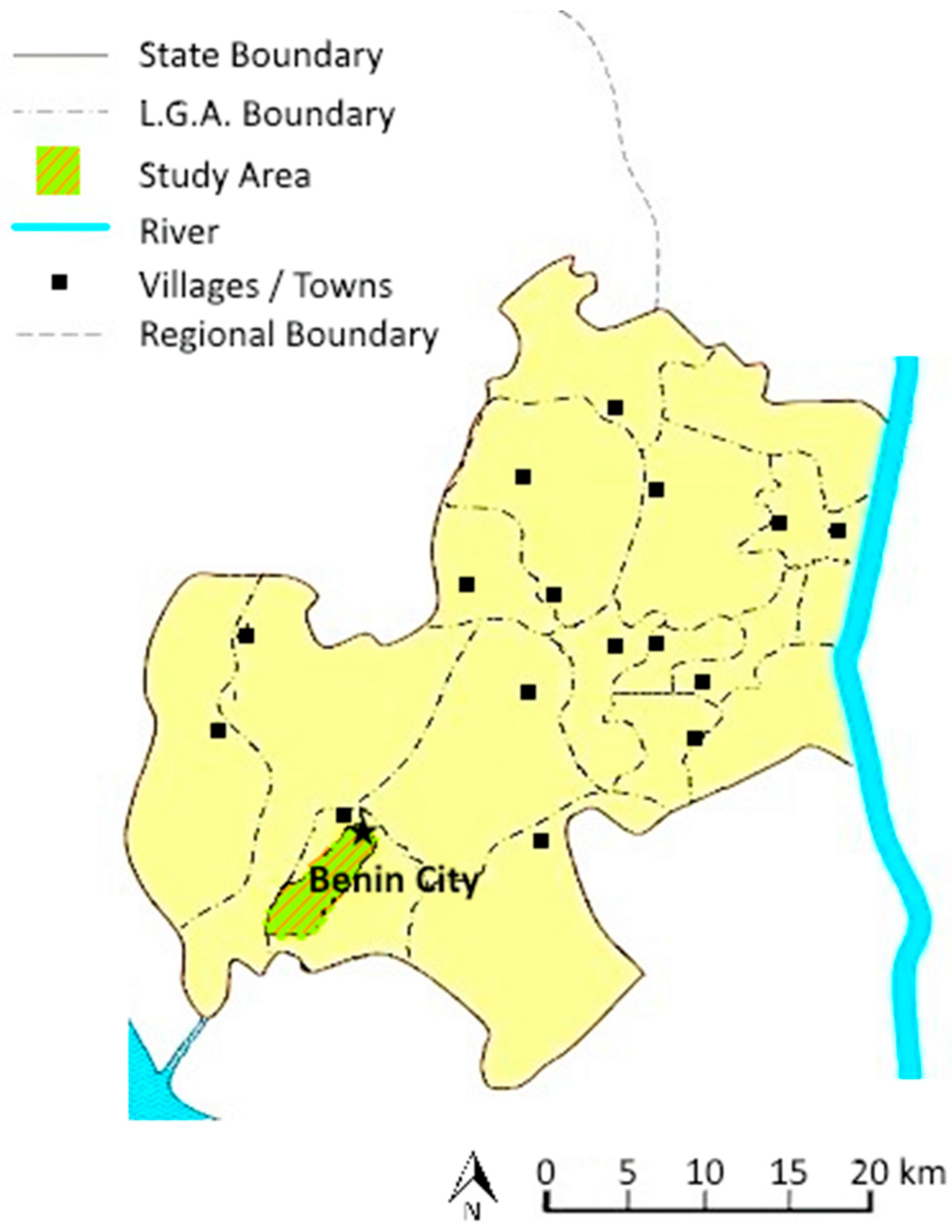
2.1. Study Area
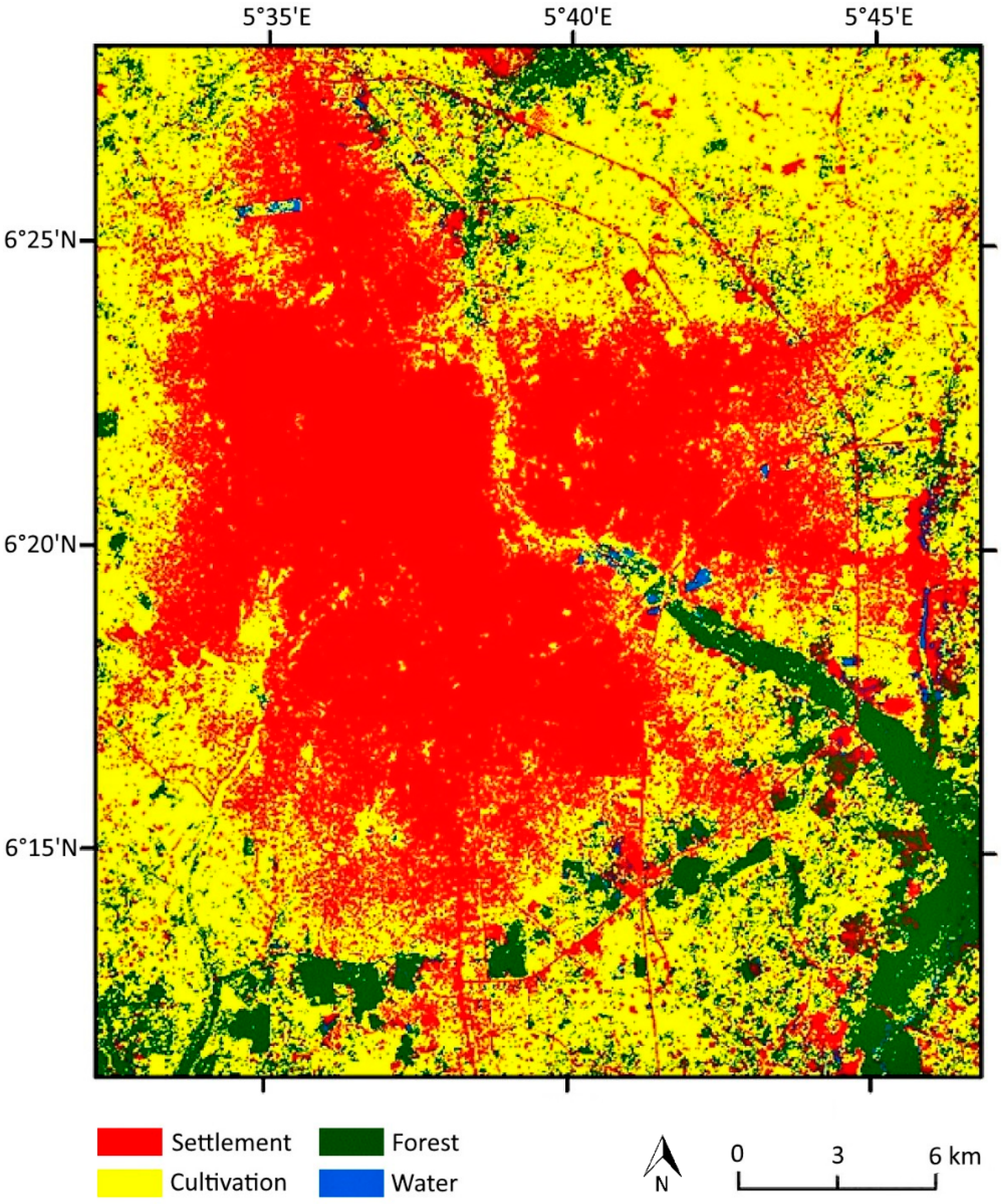
2.1.1. Latitudinal and Longitudinal Location
2.1.2. Climate
2.1.3. Vegetation and Soil Type
2.1.4. Geology, Relief, and Drainage
2.1.5. Socioeconomic Setting
2.2. Data Sources
2.3. Method of Sample Selection
3. Results
3.1. Causes of Flooding in Benin City and Mitigation Measures
3.2. Rainfall Data and Analysis
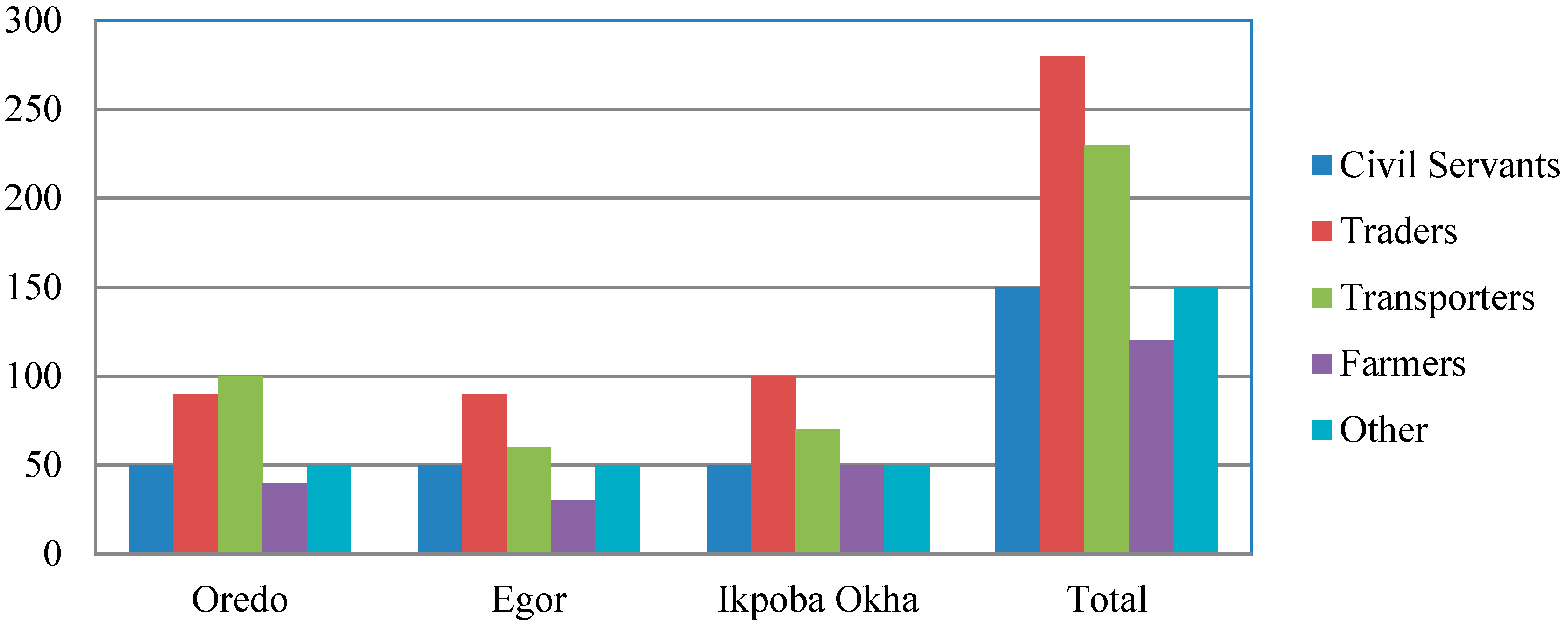
3.3. Occupational Distribution of Residents of Flood-Prone Areas
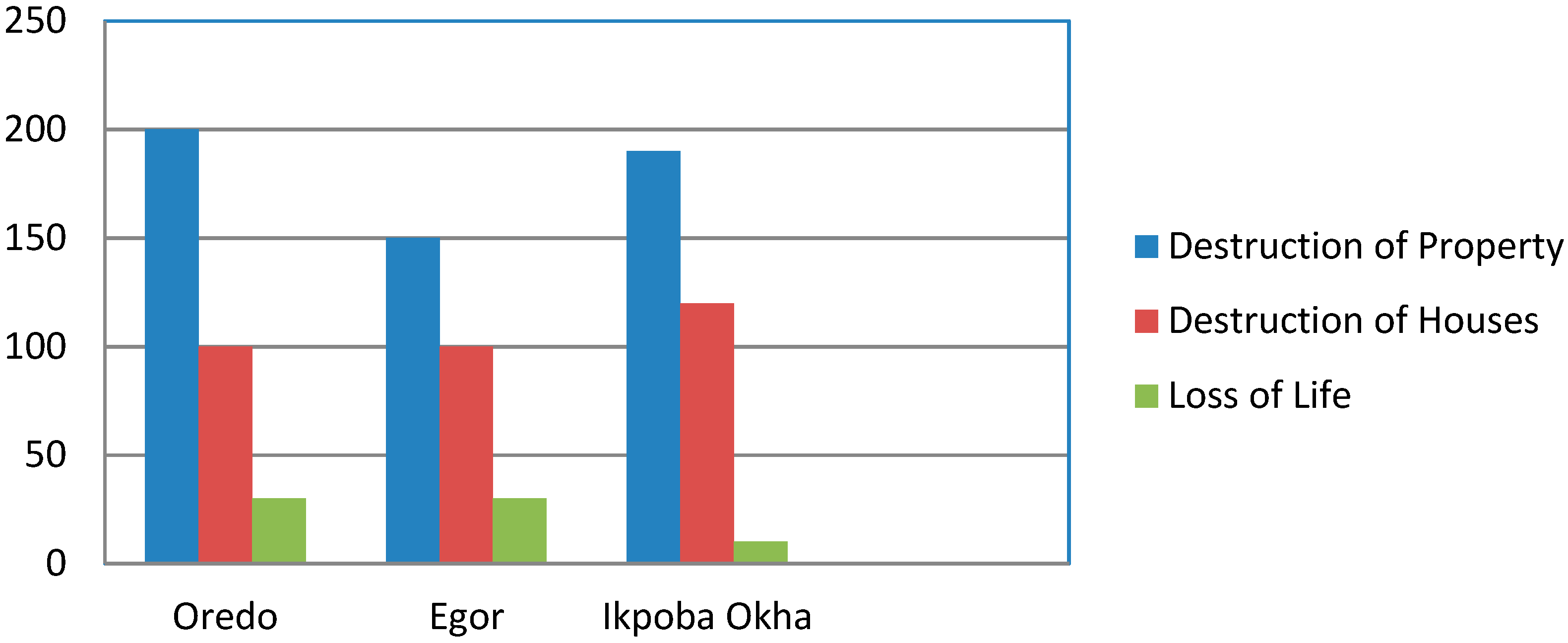
3.4. Flood Occurrence
3.5. Drainage System Information
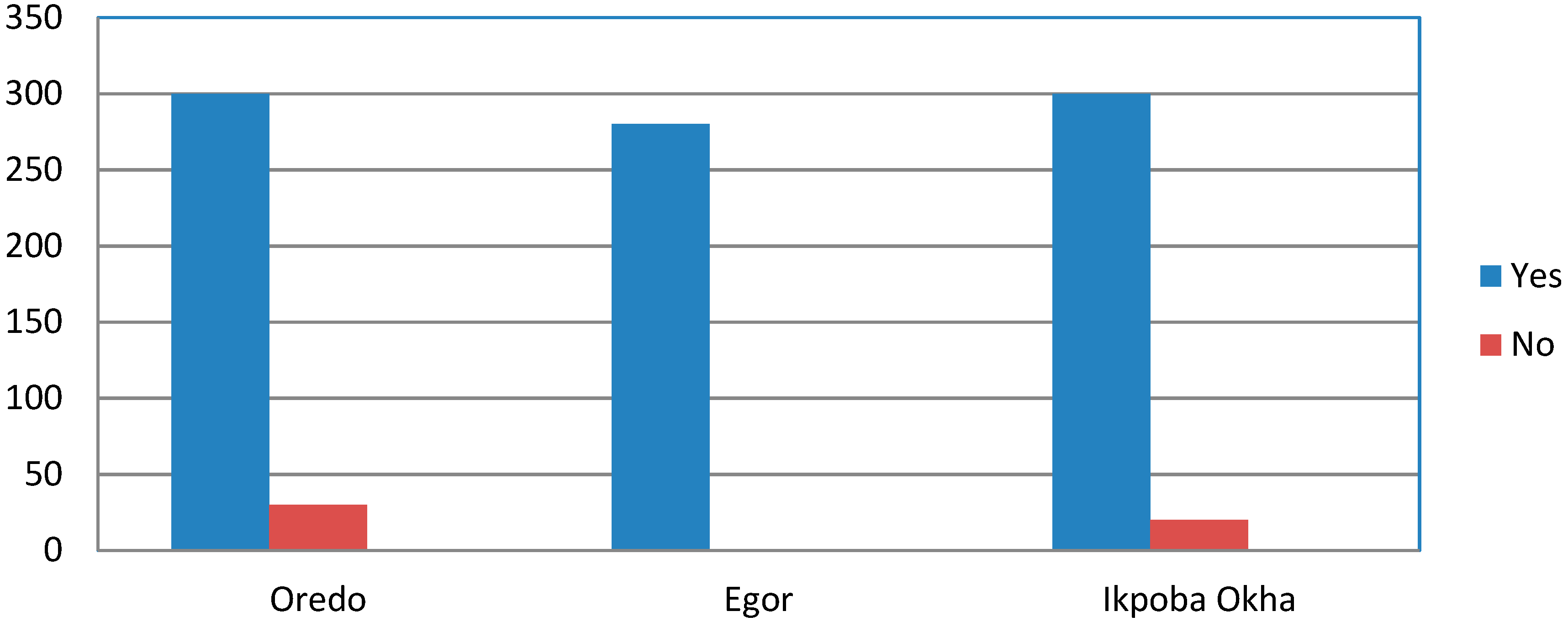
3.6. Government Control and Community Awareness
4. Discussion
5. Conclusions
Author Contributions
Funding
Conflicts of Interest
References
- Smith, K.; Ward, R. Floods: Physical Processes and Human Impacts; John Wiley & Sons: Hoboken, NJ, USA, 1998; ISBN 0471952486. [Google Scholar]
- Kolawole, O.M.; Ajayi, K.T.; Olayemi, A.B.; Okoh, A.I. Assessment of water quality in Asa River (Nigeria) and its indigenous Clarias gariepinus fish. Int. J. Environ. Res. Public Health 2011, 8, 4332–4352. [Google Scholar] [CrossRef] [PubMed]
- Ghimire, R.; Ferreira, S.; Dorfman, J.H. Flood-induced displacement and civil conflict. World Dev. 2015, 66, 614–628. [Google Scholar] [CrossRef]
- Moors, E.; Singh, T.; Siderius, C.; Balakrishnan, S.; Mishra, A. Climate change and waterborne diarrhea in northern India: Impacts and adaptation strategies. Sci. Total Environ. 2013, 468–469, S139–S151. [Google Scholar] [CrossRef] [PubMed]
- Ayoade, J.O.; Akintola, F.O. Public perception of flood hazard in two Nigerian cities. Environ. Int. 1980, 4, 277–280. [Google Scholar] [CrossRef]
- Ahern, M.; Kovats, S.; Matthies, F.; Few, R. Health impacts of flooding: A global systematic review. Epidemiology 2004, 15, 115–133. [Google Scholar] [CrossRef]
- Vitousek, S.; Barnard, P.L.; Fletcher, C.H.; Frazer, N.; Erikson, L.; Storlazzi, C.D. Doubling of coastal flooding frequency within decades due to sea-level rise. Sci. Rep. 2017, 7, 1399. [Google Scholar] [CrossRef]
- Radojevic, B.D.; Breil, P.; Chocat, B. Assessing impact of global change on flood regimes. Int. J. Clim. Chang. Strateg. Manag. 2010, 2, 167–179. [Google Scholar] [CrossRef]
- Pérez-Molina, E.; Sliuzas, R.; Flacke, J.; Jetten, V. Developing a cellular automata model of urban growth to inform spatial policy for flood mitigation: A case study in Kampala, Uganda. Comput. Environ. Urban Syst. 2017, 65, 53–65. [Google Scholar] [CrossRef]
- Adekola, P.O.; Ogundipe, A. An assessment of the state of environmental management in Nigerian capital cities. J. Geogr. Environ. Earth Sci. Int. 2017, 12, 1–13. [Google Scholar] [CrossRef]
- Few, R. Flood hazards, vulnerability and risk reduction. In Flood Hazards and Health: Responding to Present and Future Risks; Routledge: London, UK, 2013; p. 20. [Google Scholar]
- Cirella, G.T.; Iyalomhe, F.O. Flooding conceptual review: Sustainability-focalized best practices in Nigeria. Appl. Sci. 2018, 8, 1558. [Google Scholar] [CrossRef]
- Ministry of Environment. Benin City Report; Ministry of Environment, Benin City: Benin City, Nigeria, 2009. [Google Scholar]
- UNOCHA. 2013 Rainy Season Overview West and Central Africa Rainfall Patterns; United Nations Office for the Coordination of Humanitarian Affairs: Abuja, Nigeria, 2013. [Google Scholar]
- UNOCHA. Humanitarian Bulletin Nigeria; United Nations Office for the Coordination of Humanitarian Affairs: Abuja, Nigeria, 2015. [Google Scholar]
- UNOCHA. 2018 Humanitarian Response Plan: Nigeria; United Nations Office for the Coordination of Humanitarian Affairs: Abuja, Nigeria, 2017. [Google Scholar]
- Alens, O.P. Assessment of the urban climate of Benin City, Nigeria. J. Environ. Earth Sci. 2016, 6, 131–143. [Google Scholar]
- Ikhile, C.I. Geomorphology and hydrology of the Benin Region, Edo State, Nigeria. Int. J. Geosci. 2016, 7, 144–157. [Google Scholar] [CrossRef]
- Ajayi, A. Assessment of Traditional Institutions and Socio Economic Development of Benin City; Obafemi Awolowo University: Benin City, Nigeria, 2011; ISBN 9783656250357. [Google Scholar]
- Adekola, P.O.; Azuh, D.; Adeloye, D.; Amoo, E. Urban renewal in Nigeria: A slash and burn approach? Environ. Dev. Sustain. 2018, 1–18. [Google Scholar] [CrossRef]
- Osberghaus, D. The effect of flood experience on household mitigation—Evidence from longitudinal and insurance data. Glob. Environ. Chang. 2017, 43, 126–136. [Google Scholar] [CrossRef]
- Osberghaus, D. The determinants of private flood mitigation measures in Germany—Evidence from a nationwide survey. Ecol. Econ. 2015, 110, 36–50. [Google Scholar] [CrossRef]
- Lindell, M.K.; Perry, R.W. The protective action decision model: Theoretical modifications and additional evidence. Risk Anal. 2012, 32, 616–632. [Google Scholar] [CrossRef]
- UNISDR. Hyogo Framework for Action (HFA). Available online: https://www.unisdr.org/we/coordinate/hfa (accessed on 15 January 2019).
- UNISDR. Sendai Framework for Disaster Risk Reduction. Available online: https://www.unisdr.org/we/coordinate/sendai-framework (accessed on 15 January 2019).
- Chacowry, A.; McEwen, L.J.; Lynch, K. Recovery and resilience of communities in flood risk zones in a small island developing state: A case study from a suburban settlement of Port Louis, Mauritius. Int. J. Disaster Risk Reduct. 2018, 28, 826–838. [Google Scholar] [CrossRef]
- Mabuku, M.P.; Senzanje, A.; Mudhara, M.; Jewitt, G.; Mulwafu, W. Rural households’ flood preparedness and social determinants in Mwandi district of Zambia and Eastern Zambezi Region of Namibia. Int. J. Disaster Risk Reduct. 2018, 28, 284–297. [Google Scholar] [CrossRef]
- Richert, C.; Erdlenbruch, K.; Figuières, C. The determinants of households’ flood mitigation decisions in France—On the possibility of feedback effects from past investments. Ecol. Econ. 2017, 131, 342–352. [Google Scholar] [CrossRef]
- Bhattacharjee, K.; Behera, B. Does forest cover help prevent flood damage? Empirical evidence from India. Glob. Environ. Chang. 2018, 53, 78–89. [Google Scholar] [CrossRef]
- Bubeck, P.; Botzen, W.J.W.; Kreibich, H.; Aerts, J.C.J.H. Detailed insights into the influence of flood-coping appraisals on mitigation behaviour. Glob. Environ. Chang. 2013, 23, 1327–1338. [Google Scholar] [CrossRef]
- Ejeta, L.T. Community’s emergency preparedness for flood hazards in Dire-dawa Town, Ethiopia: A qualitative study. PLoS Curr. 2018. [Google Scholar] [CrossRef] [PubMed]
- Theresa, C.; Ugwuanyi, R.O. Emergency management and disaster risk reduction as tools for sustainable development in Nigeria: Environment Project. Available online: https://www.researchgate.net/publication/319448898_Emergency_Management_and_Disaster_Risk_Reduction_as_Tools_For_Sustainable_Development_in_Nigeria (accessed on 20 February 2019).
- Wand, M.Z.; Ayuba, I.G.U.; Asika, B.G. Needs for disaster risks reduction education in Nigeria. IOSR J. Environ. Sci. Toxicol. Food Technol. 2015, 9, 43–47. [Google Scholar]
- Iloka, N.G. Indigenous knowledge for disaster risk reduction: An African perspective. Jàmbá J. Disaster Risk Stud. 2016, 8, 272. [Google Scholar] [CrossRef]
- Walch, C. Adaptive governance in the developing world: Disaster risk reduction in the State of Odisha, India. Clim. Dev. 2018, 1–15. [Google Scholar] [CrossRef]
- Al-Nammari, F.; Alzaghal, M. Towards local disaster risk reduction in developing countries: Challenges from Jordan. Int. J. Disaster Risk Reduct. 2015, 12, 34–41. [Google Scholar] [CrossRef]
- Baytiyeh, H. Can disaster risk education reduce the impacts of recurring disasters on developing societies? Educ. Urban Soc. 2018, 50, 230–245. [Google Scholar] [CrossRef]
- Richard Eiser, J.; Bostrom, A.; Burton, I.; Johnston, D.M.; McClure, J.; Paton, D.; van der Pligt, J.; White, M.P. Risk interpretation and action: A conceptual framework for responses to natural hazards. Int. J. Disaster Risk Reduct. 2012, 1, 5–16. [Google Scholar] [CrossRef]
- Rufat, S.; Tate, E.; Burton, C.G.; Maroof, A.S. Social vulnerability to floods: Review of case studies and implications for measurement. Int. J. Disaster Risk Reduct. 2015, 14, 470–486. [Google Scholar] [CrossRef]
- Huguet, J.R.; Bertin, X.; Arnaud, G. Managed realignment to mitigate storm-induced flooding: A case study in La Faute-sur-mer, France. Coast. Eng. 2018, 134, 168–176. [Google Scholar] [CrossRef]
- McEwen, L.; Holmes, A.; Quinn, N.; Cobbing, P. ‘Learning for resilience’: Developing community capital through flood action groups in urban flood risk settings with lower social capital. Int. J. Disaster Risk Reduct. 2018, 27, 329–342. [Google Scholar] [CrossRef]
- Shah, M.A.R.; Rahman, A.; Chowdhury, S.H. Sustainability assessment of flood mitigation projects: An innovative decision support framework. Int. J. Disaster Risk Reduct. 2017, 23, 53–61. [Google Scholar] [CrossRef]
- Islam, M.; Kotani, K.; Managi, S. Climate perception and flood mitigation cooperation: A Bangladesh case study. Econ. Anal. Policy 2016, 49, 117–133. [Google Scholar] [CrossRef]
- Albano, R.; Sole, A.; Adamowski, J.; Perrone, A.; Inam, A. Using Flood Risk GIS freeware for uncertainty analysis of direct economic flood damages in Italy. Int. J. Appl. Earth Obs. Geoinf. 2018, 73, 220–229. [Google Scholar] [CrossRef]
- Djimesah, I.E.; Okine, A.N.D.; Kissi Mireku, K. Influential factors in creating warning systems towards flood disaster management in Ghana: An analysis of 2007 Northern flood. Int. J. Disaster Risk Reduct. 2018, 28, 318–326. [Google Scholar] [CrossRef]


| LGAs | Population 1 | Civil Servants | Traders | Transporters | Farmers | Other | Total |
|---|---|---|---|---|---|---|---|
| Oredo | 374,515 | 50 | 100 | 100 | 50 | 50 | 350 |
| Egor | 340,287 | 50 | 100 | 100 | 50 | 50 | 350 |
| Ikpoba Okha | 372,080 | 50 | 100 | 100 | 50 | 50 | 350 |
| Total | 1,086,882 | 150 | 300 | 300 | 150 | 150 | 1050 |
| Unreturned questionnaires | 0 | 20 | 70 | 30 | 0 | 120 | |
| Total returned questionnaires | 150 | 280 | 230 | 120 | 150 | 930 | |
| Causes of Floods | Oredo | Egor | Ikpoba Okha | Total | % |
|---|---|---|---|---|---|
| Heavy rainfall | 130 | 120 | 120 | 370 | 40 |
| Blockage of waterways | 100 | 70 | 120 | 290 | 31 |
| Building on flood plains | 40 | 30 | 30 | 100 | 11 |
| Poor planning/land use | 60 | 60 | 50 | 170 | 18 |
| Total | 330 | 280 | 320 | 930 | 100 |
| Year | Annual Rainfall (mm) (x) | Mean Difference (mm) (x − μ) | Squared Difference (x − μ)2 |
|---|---|---|---|
| 2000 | 1816.3 | −97.97 | 9598.84 |
| 2001 | 1709.5 | −204.77 | 41,932.26 |
| 2002 | 2135.8 | 221.53 | 49,073.91 |
| 2003 | 1703.0 | −211.27 | 44,636.57 |
| 2004 | 1928.8 | 14.53 | 211.01 |
| 2005 | 1595.0 | −319.27 | 101,935.68 |
| 2006 | 1972.9 | 58.63 | 3437.05 |
| 2007 | 2036.5 | 122.23 | 14,939.27 |
| 2008 | 1891.7 | −22.57 | 509.57 |
| 2009 | 1792.0 | −122.27 | 14,950.85 |
| 2010 | 1814.3 | −99.97 | 9994.74 |
| 2011 | 2087.3 | 173.03 | 29,938.11 |
| 2012 | 2369.8 | 455.53 | 207,504.23 |
| 2013 | 2251.2 | 336.93 | 113,519.35 |
| 2014 | 1734.8 | −179.47 | 32,210.80 |
| 2015 | 1674.0 | −240.27 | 57,731.44 |
| 2016 | 1701.6 | −212.67 | 45,230.09 |
| 2017 | 1589.3 | −324.97 | 105,607.89 |
| 2018 | 2567.4 | 653.13 | 426,573.99 |
| N = 19 | μ = 1914.27 | σ2 = 68,922.93 σ = 262.53 |
| Flood Inconveniences | Oredo | Egor | Ikpoba Okha | Total | % |
|---|---|---|---|---|---|
| Relocation of property | 70 | 70 | 50 | 190 | 20 |
| Abandonment of houses | 110 | 90 | 150 | 350 | 38 |
| Psychological fear | 100 | 60 | 80 | 240 | 26 |
| Abandonment and relocation | 50 | 60 | 40 | 150 | 16 |
| Total | 330 | 280 | 320 | 930 | 100 |
| Flood Control Measures | Oredo | Egor | Ikpoba Okha | Total | % |
|---|---|---|---|---|---|
| Desilting of drainages | 50 | 20 | 20 | 90 | 10 |
| Drainage networks | 130 | 90 | 90 | 310 | 33 |
| Creation of canals | 0 | 30 | 20 | 50 | 5 |
| None | 150 | 140 | 190 | 480 | 52 |
| Total | 330 | 280 | 320 | 930 | 100 |
| Suggested Control Measures | Oredo | Egor | Ikpoba Okha | Total | % |
|---|---|---|---|---|---|
| Creation of drainage networks | 170 | 170 | 170 | 510 | 55 |
| Raised foundation | 0 | 40 | 0 | 40 | 4 |
| Sand bags | 0 | 0 | 30 | 30 | 3 |
| Proper land use planning | 100 | 40 | 70 | 210 | 23 |
| Flood insurance | 60 | 30 | 50 | 140 | 15 |
| Total | 330 | 280 | 320 | 930 | 100 |
© 2019 by the authors. Licensee MDPI, Basel, Switzerland. This article is an open access article distributed under the terms and conditions of the Creative Commons Attribution (CC BY) license (http://creativecommons.org/licenses/by/4.0/).
Share and Cite
Cirella, G.T.; Iyalomhe, F.O.; Adekola, P.O. Determinants of Flooding and Strategies for Mitigation: Two-Year Case Study of Benin City. Geosciences 2019, 9, 136. https://doi.org/10.3390/geosciences9030136
Cirella GT, Iyalomhe FO, Adekola PO. Determinants of Flooding and Strategies for Mitigation: Two-Year Case Study of Benin City. Geosciences. 2019; 9(3):136. https://doi.org/10.3390/geosciences9030136
Chicago/Turabian StyleCirella, Giuseppe T., Felix O. Iyalomhe, and Paul O. Adekola. 2019. "Determinants of Flooding and Strategies for Mitigation: Two-Year Case Study of Benin City" Geosciences 9, no. 3: 136. https://doi.org/10.3390/geosciences9030136
APA StyleCirella, G. T., Iyalomhe, F. O., & Adekola, P. O. (2019). Determinants of Flooding and Strategies for Mitigation: Two-Year Case Study of Benin City. Geosciences, 9(3), 136. https://doi.org/10.3390/geosciences9030136