Geotourism Perspectives for Transhumance Routes. Analysis, Requalification and Virtual Tools for the Geoconservation Management of the Drove Roads in Southern Italy
Abstract
1. Introduction
1.1. Geotourism Perspectives for the Promotion of Integrated Cultural Landscapes
1.2. Transhumance Routes as Integrated Cultural Landscape and Potential Geotourism Product
2. Materials and Methods
2.1. A Geo-Historical Perspective: The Heritage of the Dogana Reinstatement Documents
2.2. The Vegetation Index as An Instrument for Assessing Conservation and Fruition
2.3. GIS and Cultural Virtual Environment for Geotourism Enhancement
3. Geo-Historical Evidence and Geotourism Potential of the Drove Roads in a Man and Biosphere Area
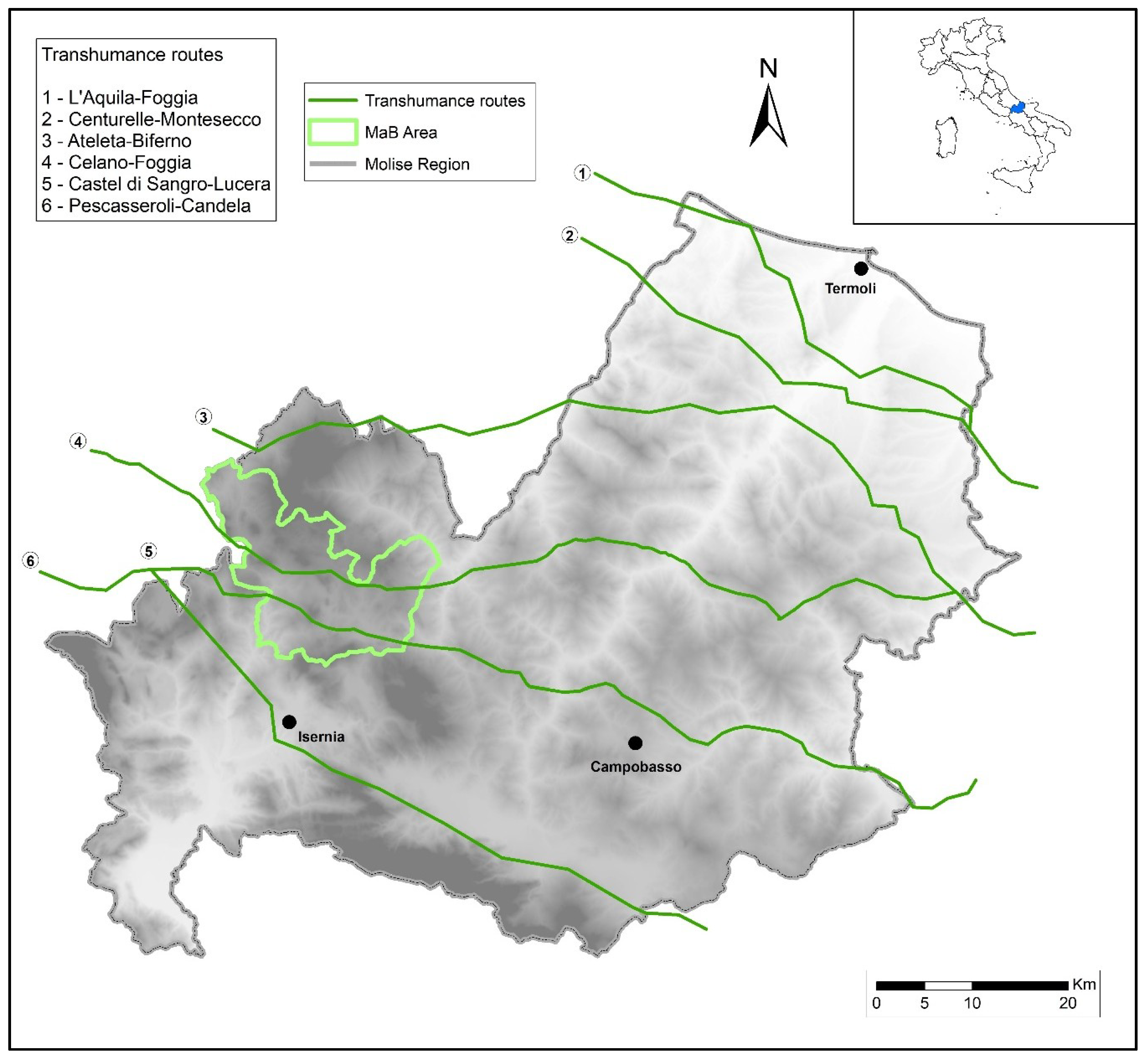
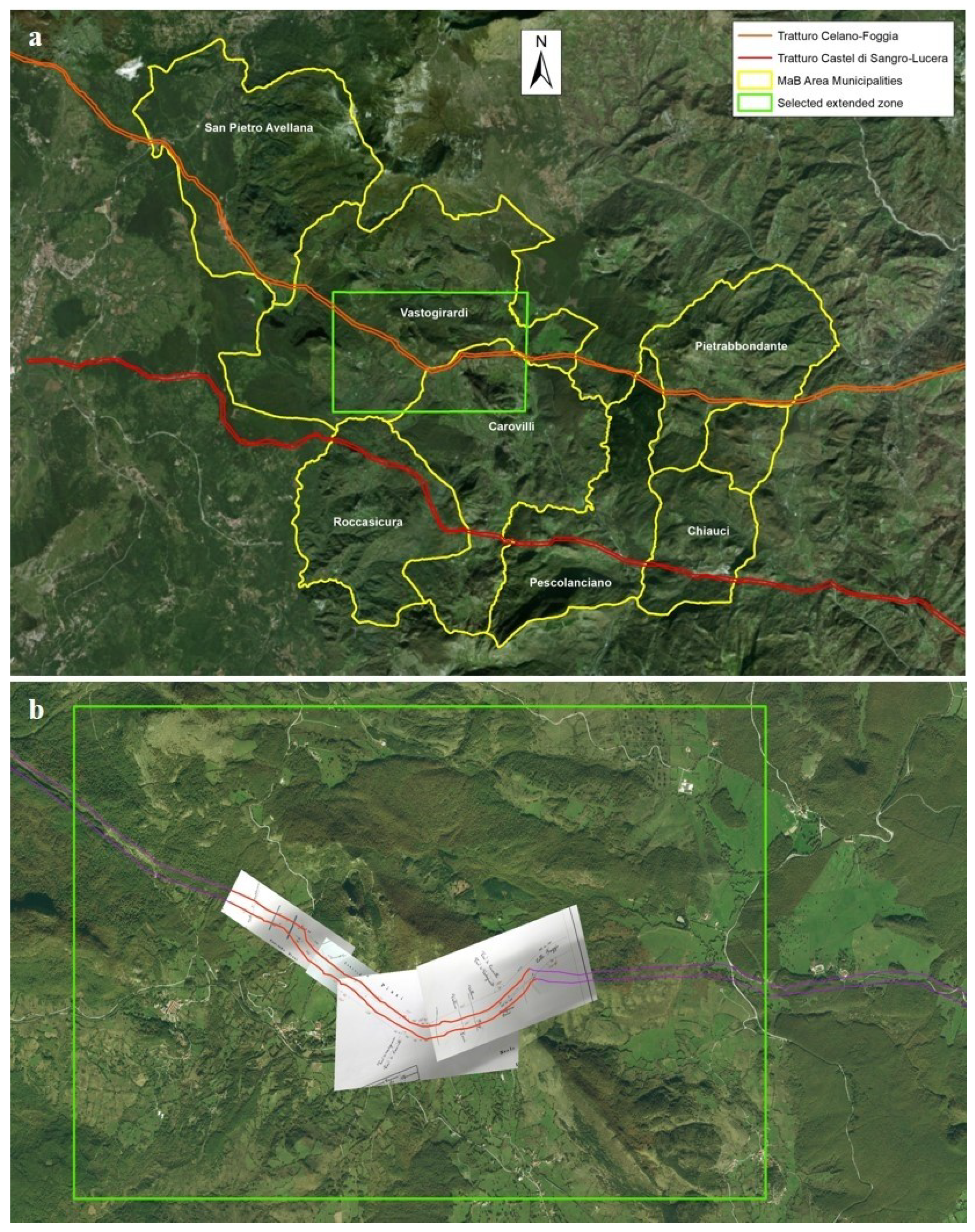
3.1. The Application to the Study Area
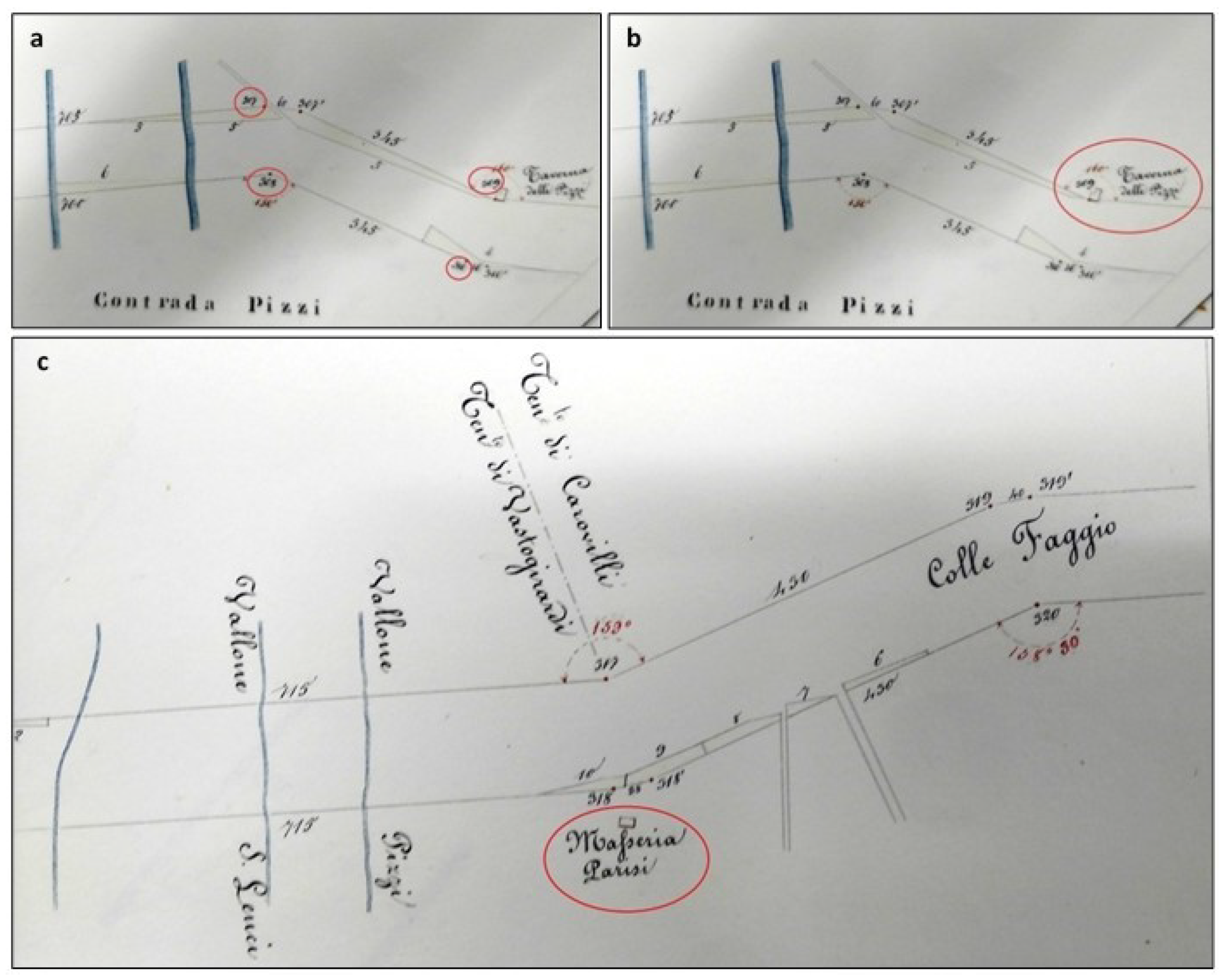
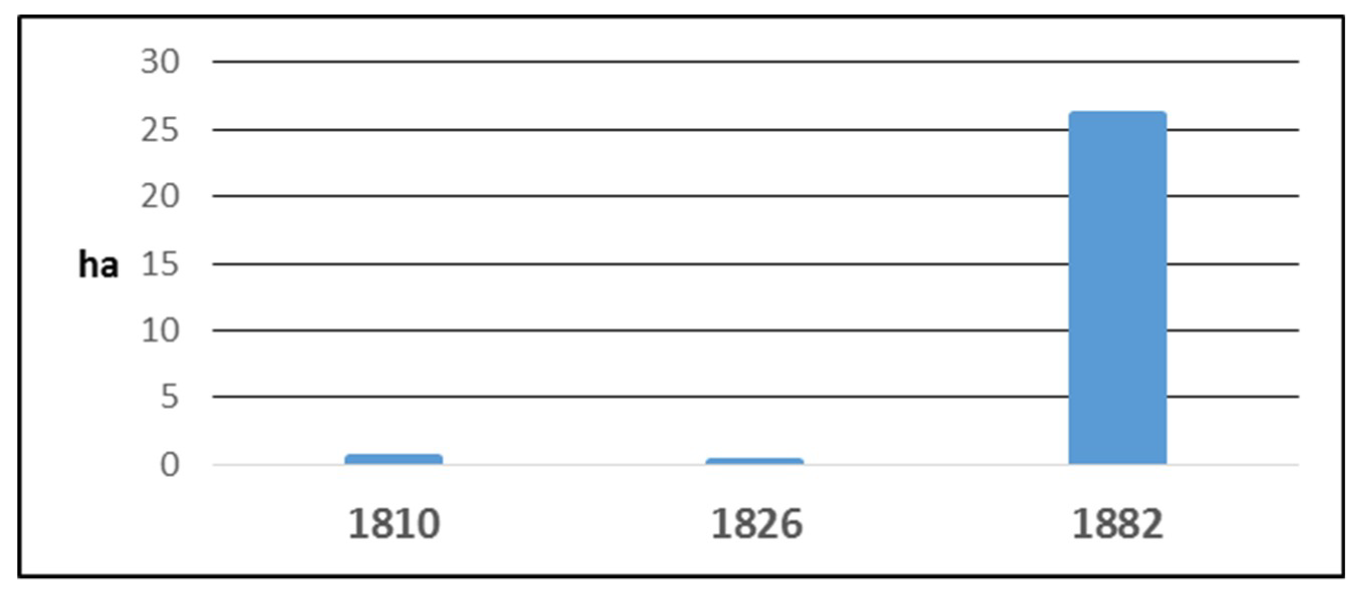
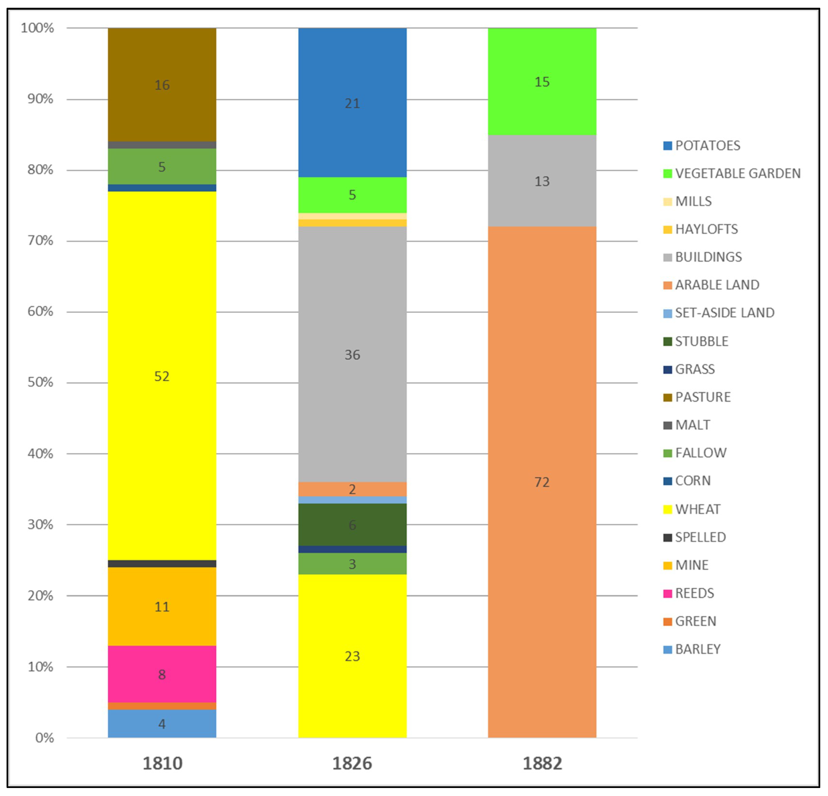
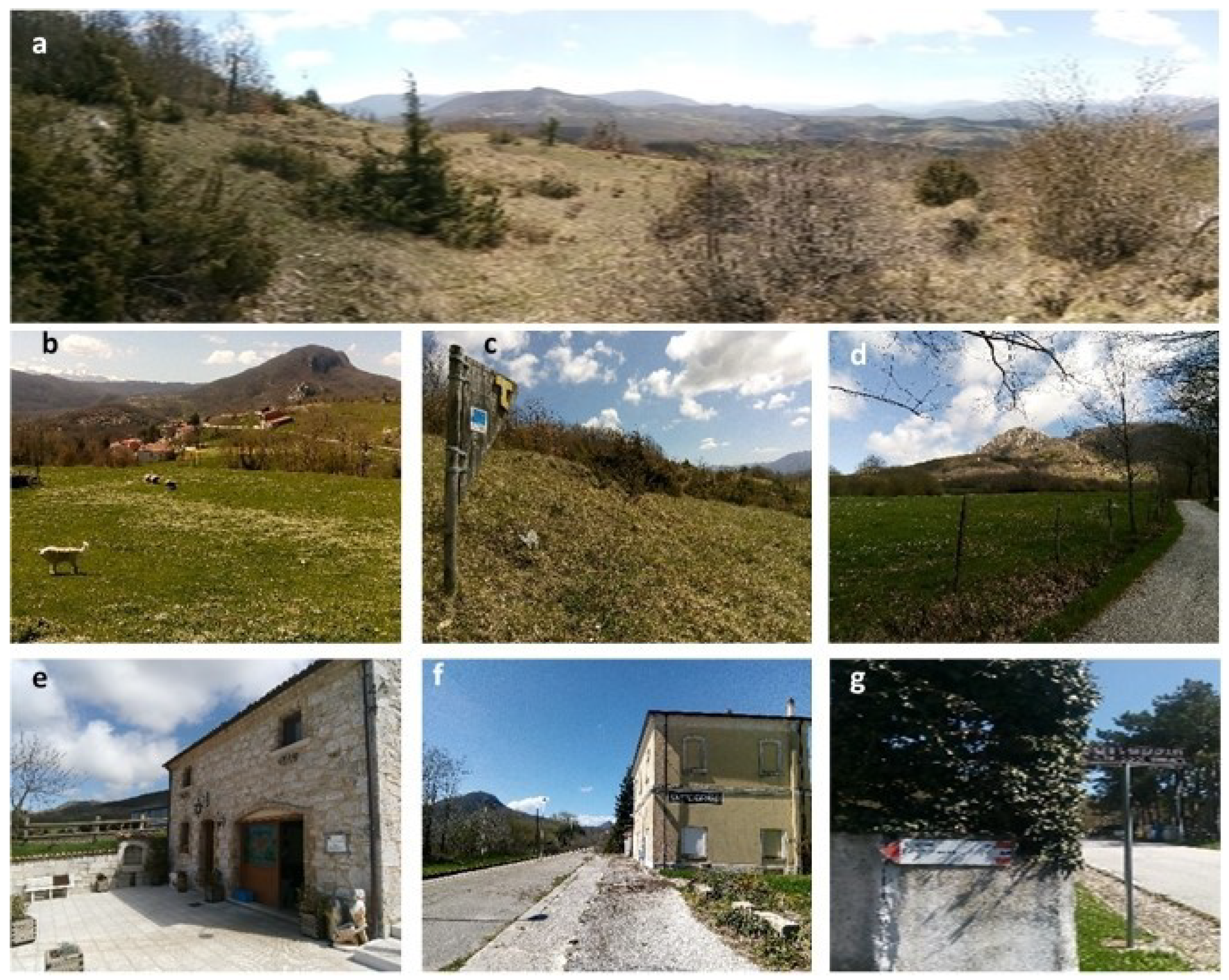
3.2. The Promiscuity of the Transhumance Landscape: Geo-Historical Signs
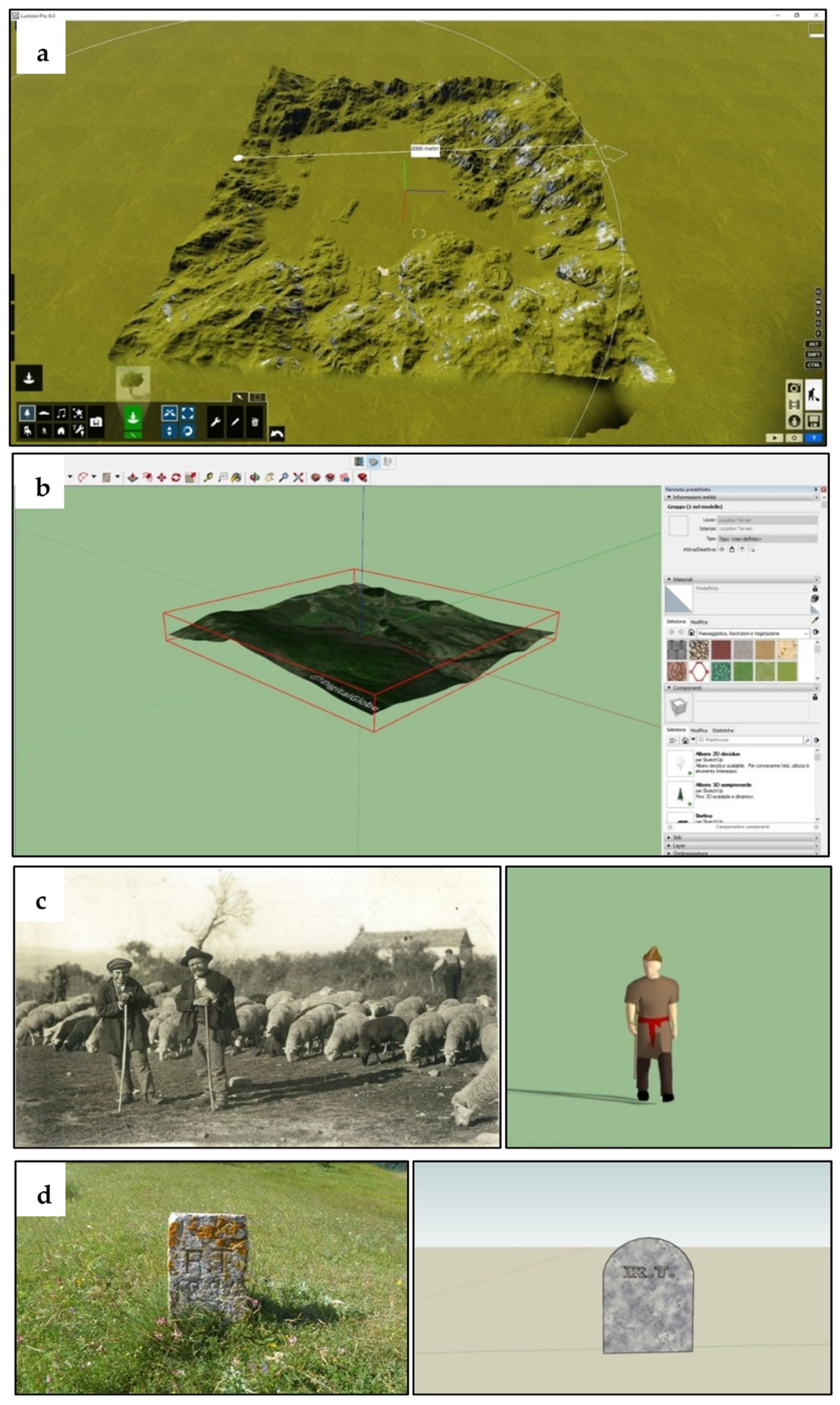
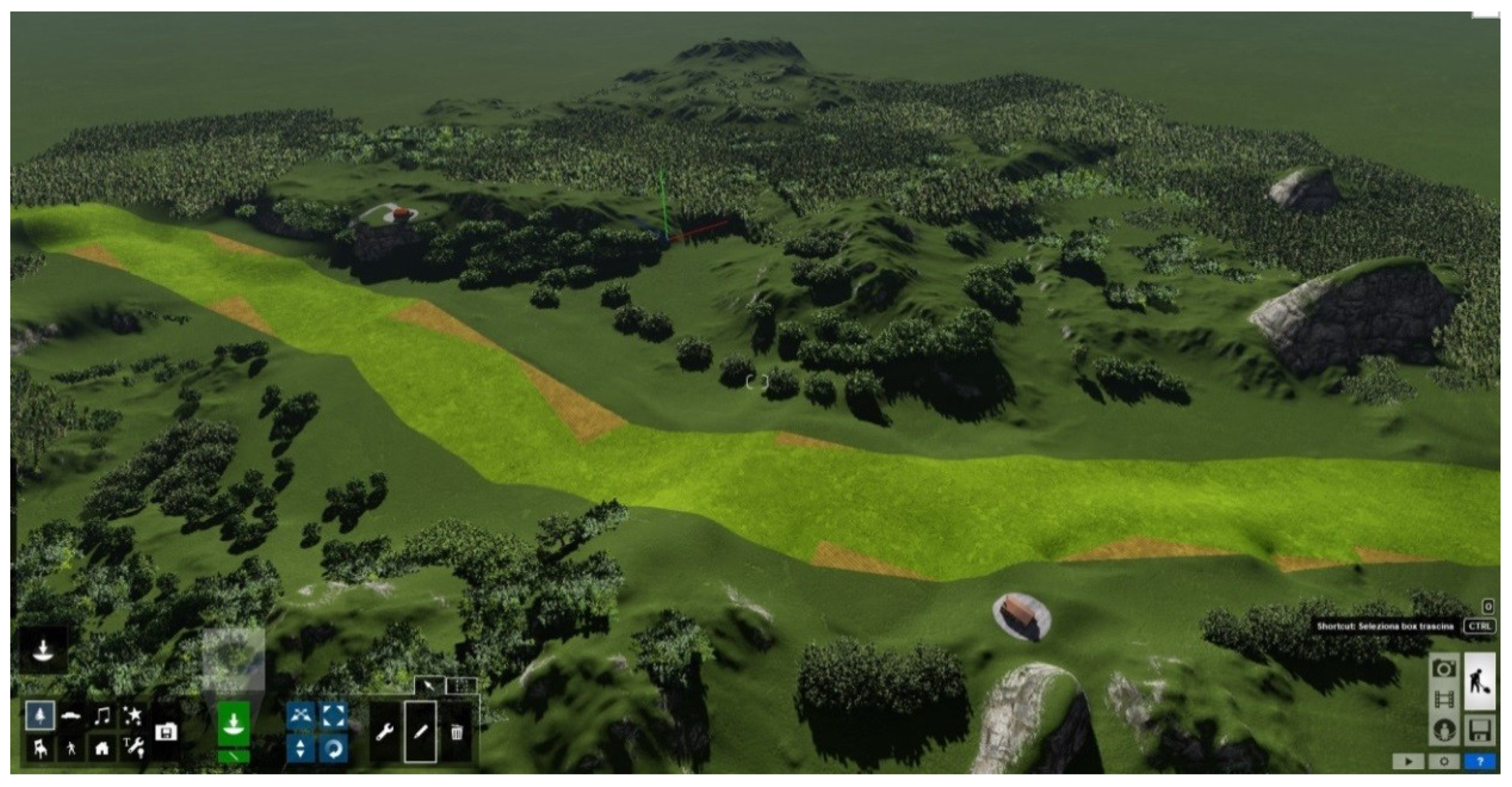
3.3. A Virtual Model for the Representation of the Transhumance Landscape
- Organization of information layers from different periods testifying to the territorial evolutions and stratifications, identifying the most characteristic elements of transhumance landscape that need to be conserved and valorised;
- Space-time contextualization of the cultural assets of the transhumance landscape, localizing tangible signs and intangible values sources and setting both of them in a unique system of relations that gives significance to geoheritage;
- Production of knowledge-based communication tools, useful for promotion strategies, for educational applications, tourism enhancement.
- Digitization and georeferencing;
- 3D modeling of the selected area and the elements of the landscape;
- Importing models and 3D rendering of the area with Lumion 6.0 (Varmond, The Netherlands).
- Living and moving elements—shepherd, dog, taverna owners, masseria owners;
- Stationary elements–limit stones, occupied land, taverna, masseria.
3.4. A First Step in the Fruition Analysis
4. Discussion and Conclusions
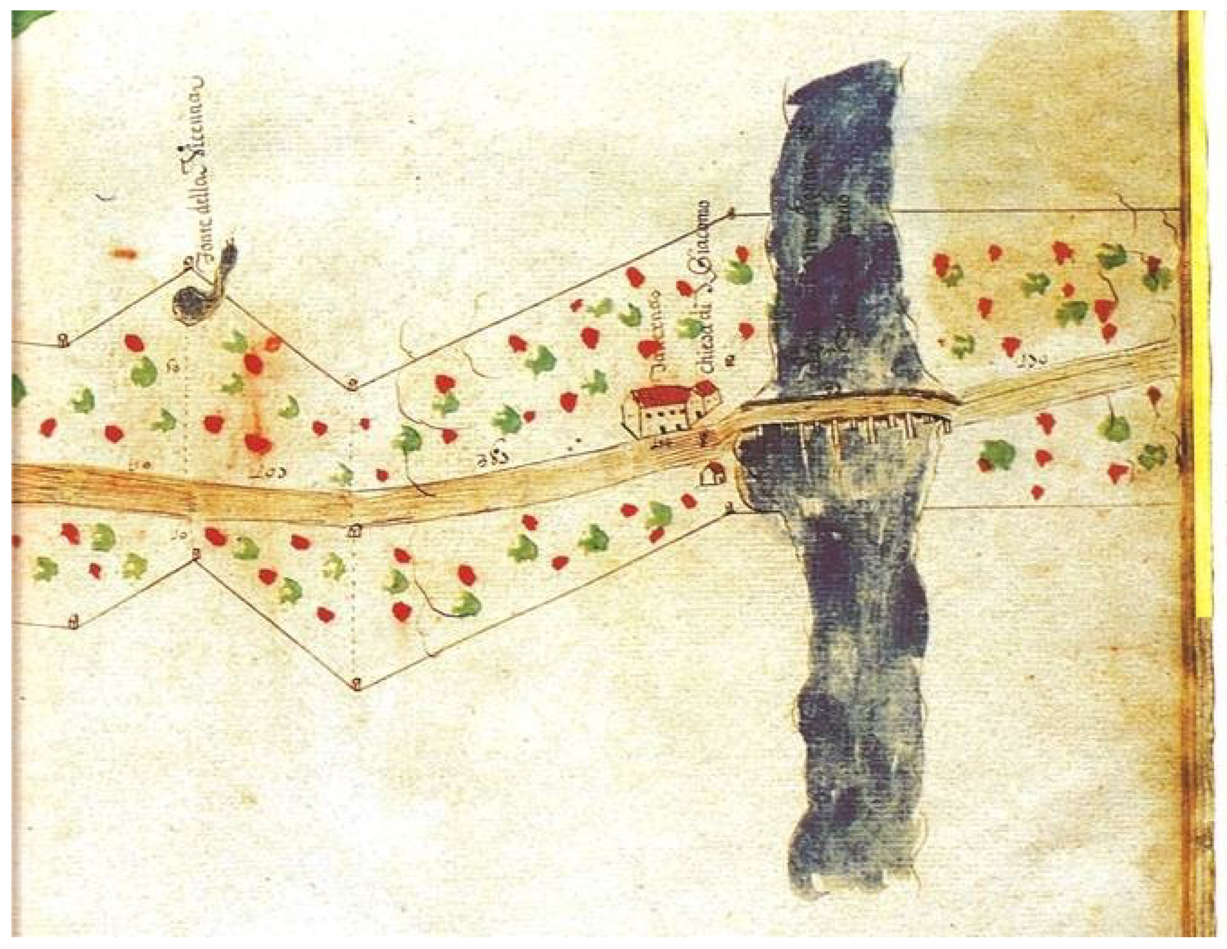
- The geo-historical approach highlighted the strong relationship between the anthropic and the natural aspects of the territory, with evidence in the localization and the architecture of permanent and temporary buildings and infrastructures. Moreover, it led to the comprehension of the complexity of transhumance landscape. In particular, it pointed out the structure of a landscape characterized by an overlap of pastoral and agricultural signs whose traces are well documented by the analysed historic atlases. Particularly for the case-study, the phenomenon was more evident in those territories with a long tradition of an agro-pastoral entrepreneurship linked to noble families (i.e., the D’Alessandro, dukes of Pescolanciano), who were locati during the ancien regime and landowners during the nineteenth century. Geo-historical analysis allowed to explain—as other studies have recently done [116]—the promiscuous nature of a mountain area where agricultural and pastoral economies coexist, confirming that promiscuity is one of the fundamental traits of the Mediterranean region landscape and identity [38]. The landscape of transhumance, as a part and a significant type of this complex landscape system, is no exception, even in the core of internal areas, where indeed a great heritage has been protected which turns out to be very useful today for a geo-historical reconstruction aimed at geotourism enhancement.
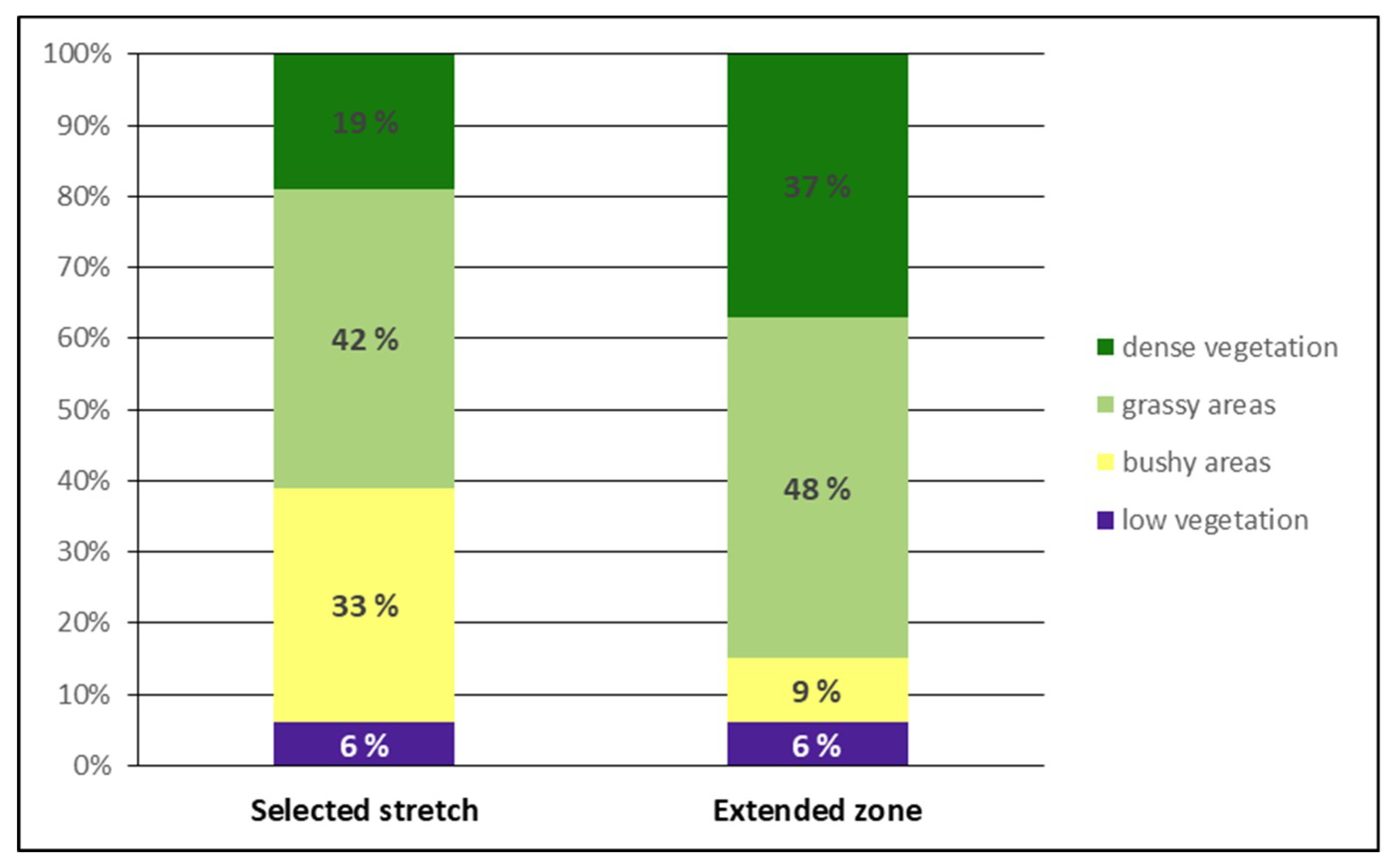
- The integrated use of satellite images and vegetation index proved to be a good instrument to identify the best preserved areas on which subsequent inspections should be concentrated aimed at comprehending the degree of geoconservation and usability of the transhumance routes. Moreover, the application to the selected stretch of the Tratturo Celano-Foggia enabled us to comprehend that, due to the abandonment of the transhumance practice in the last decades, nowadays the greenest areas are not inside but outside the drove roads and these can be used for other purposes, such as recreation and geotourism. Finally, the vegetation index proved to be a valid tool for assessing potential geotourism fruition of the drove roads, allowing to verify the continuity of the track in specific areas that deserve requalification and promotion.
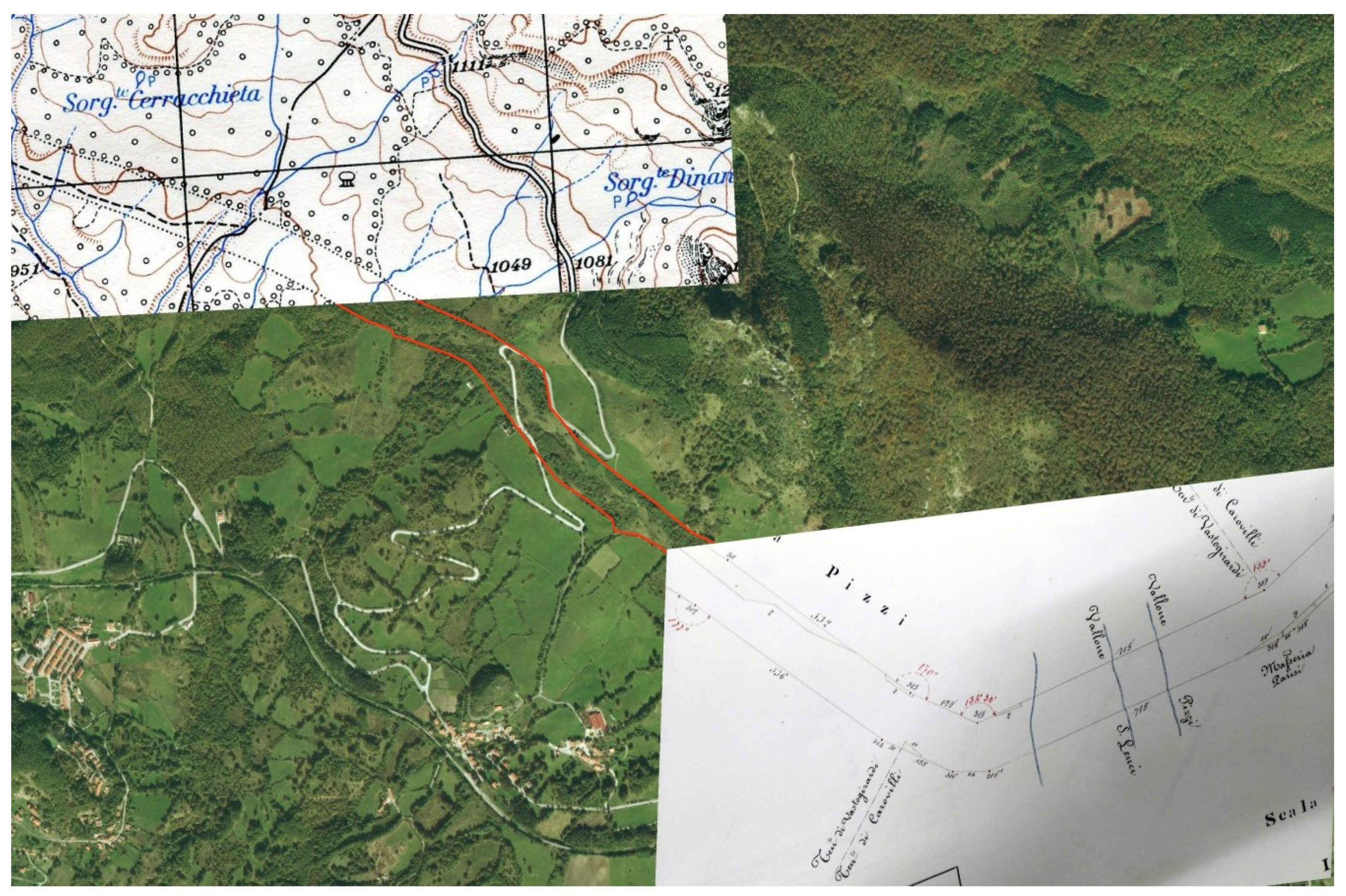
- Contextualized historic maps and Cultural Virtual Environment approach, together with 3D virtual rendering tools, allowed to better understand the potential of rescuing a landscape that in some cases has completely disappeared and only a scientific reconstruction like the one here proposed can bring it in use again. The application of this method on a regional scale opens the possibility to create dedicated web-GIS aimed at the accurate visualization of information in a layered virtual environment where data are collected, processed, distributed, developed, analysed and accessed [117]. Geographic Information Systems can also provide the basis for new geomedia products that can be retrieved remotely or in situ, in order to enhance the attractiveness of drove roads and create narrative tools for transhumance landscapes [118]. The results of our research offer a remarkable quantity of reflections useful for discussing future perspectives.
Author Contributions
Funding
Acknowledgments
Conflicts of Interest
References
- Cooke, P.; Parrilli, M.D.; Curbelo, J.L. Innovation, Global Change and Territorial Resilience; Edward Elgar Publishing: Cheltenham, UK, 2012. [Google Scholar]
- Timothy, D.J.; Boyd, S.W. Heritage Tourism in the 21st Century: Valued Traditions and New Perspectives. J. Herit. Tour. 2006, 1, 1–16. [Google Scholar] [CrossRef]
- Berque, A. Médiance De Milieux en Paysages; GIP Reclus: Montpellier, France, 1990. [Google Scholar]
- WTTC; WTO; Earth Council. Agenda 21 for the Travel and Tourism Industry: Towards Environmentally Sustainable Development; WTTC: London, UK, 1995. [Google Scholar]
- UNEP; UNWTO. Making Tourism More Sustainable—A Guide for Policy Makers. 2005. Available online: http://www.unep.fr/shared/publications/pdf/dtix0592xpa-tourismpolicyen.pdf (accessed on 26 September 2018).
- Miossec, J.M. L’image touristique comme introduction à la géographie du tourisme. Ann. Géogr. 1977, 86, 55–70. [Google Scholar] [CrossRef]
- Minca, C. Spazi Effimeri; CEDAM: Padova, Italy, 1996. [Google Scholar]
- Selwyn, T. The Tourist Image: Myths and Myth Making in Tourism; Wiley: Chichester, UK, 1996. [Google Scholar]
- Lozato-Giotart, J.-P. Géographie du Tourisme: De L’espace Regardé à L’espace Consommé; Masson: Paris, France, 1985. [Google Scholar]
- Camagni, R. Innovation Networks. Spatial Perspectives; Belhaven Press: London, UK, 1991. [Google Scholar]
- Ruban, D. Geotourism-A geographical review of the literature. Tour. Manag. Perspect. 2015, 15, 1–15. [Google Scholar] [CrossRef]
- Henriques, M.H.; Brilha, J. UNESCO Global Geoparks: A strategy towards global understanding and sustainability. Episodes 2017, 40, 349–355. [Google Scholar] [CrossRef]
- Ólafsdóttir, R.; Tverijonaite, E. Geotourism: A systematic literature review. Geosciences 2018, 8, 234. [Google Scholar] [CrossRef]
- Stokes, A.M.; Cook, S.D.; Drew, D. The Geotourism Study: Phase 1 Executive Summary; Travel Industry Association of America: Washington, DC, USA, 2002. [Google Scholar]
- Stokes, A.M.; Cook, S.D.; Drew, D. Geotourism: The New Trend in Travel; Travel Industry America and National Geographic Traveler: Washington, DC, USA, 2003. [Google Scholar]
- Hose, T. Telling the story of stone—Assessing the client base. In Geological and Landscape Conservation; O’Halloran, D., Green, C., Harley, M., Knill, J., Eds.; Geological Society: London, UK, 1994; pp. 451–457. [Google Scholar]
- Newsome, D.; Dowling, R.K. The Scope and Nature of Geotourism. In Geotourism; Newsome, D., Dowling, R.K., Eds.; Elsevier Butterworth-Heinemann: Oxford, UK, 2006; pp. 3–25. [Google Scholar]
- Dowling, R. Geotourism’s Global Growth. Geoheritage 2011, 3, 1–13. [Google Scholar] [CrossRef]
- Pralong, J.-P. A method for assessing the tourist potential and use of geomorphological sites. Géomorphologie 2015, 3, 189–196. [Google Scholar] [CrossRef]
- Reynard, E.; Holzmann, C.; Guex, D.; Summermatter, N. (Eds.) Géomorphologie et tourisme: quelles relations? In Géomorphologie et Tourisme; Travaux et Recherches: Lausanne, Switzerland, 2003; pp. 1–10. [Google Scholar]
- Touring Club Italiano. Il Paesaggio; TCI: Milano, Italy, 1963. [Google Scholar]
- Grove, A.T.; Rackham, O. The Nature of Mediterranean Europe: An Ecological History; Yale University Press: New Haven, CT, USA, 2001. [Google Scholar]
- Mautone, M.; Ronza, M. (Eds.) Patrimonio Culturale e Paesaggio. Un Approccio di Filiera per la Progettualità Territoriale; CNR Dip. Patrimonio Culturale, Gangemi editore: Roma, Italy, 2009. [Google Scholar]
- Reynard, E. Scientific research and tourist promotion of geomorphological heritage. Geogr. Fis. Din. Quat. 2008, 31, 225–230. [Google Scholar]
- Panizza, M. Géomorphologie et tourisme dans un paysage culturel intégré. In Géomorphologie et Tourisme, Actes de la Réunion Annuelle de la Société Suisse de Géomorphologie (SSGm); Reynard, E., Holzmann, C., Guex, D., Summermatter, N., Eds.; Institut de Géographie, Travaux et Recherches: Lausanne, Switzerland, 2003; pp. 11–20. [Google Scholar]
- Stoffelen, A.; Vanneste, D. An integrative geotourism approach: Bridging conflicts in tourism landscape research. Tour. Geogr. 2015, 17, 544–560. [Google Scholar] [CrossRef]
- Meini, M. Turismo culturale e identità locale. Riconsiderando il ruolo del paesaggio. In Il Turismo tra Teoria e Prassi; Zilli, I., Ed.; NIS: Napoli, Italy, 2007; pp. 165–182. [Google Scholar]
- Meini, M. Il paesaggio, luogo d’incontro culturale: fra punti di vista diversi, fra insider e outsider, fra passato e futuro. In Mobilità e Territorio. Flussi, Attori, Strategie; Meini, M., Ed.; Patron: Bologna, Italy, 2008; pp. 209–215. [Google Scholar]
- Urry, J. The Tourist Gaze; Sage: London, UK, 1990. [Google Scholar]
- Ardoin, N.M.; Wheaton, M.; Bowers, A.W.; Hunt, C.A.; Durham, W.H. Nature-based tourism’s impact on environmental knowledge, attitudes, and behavior: A review and analysis of the literature and potential future research. J. Sustain. Tour. 2015, 23, 838–858. [Google Scholar] [CrossRef]
- Silva, C.; Kastenholz, E.; Abrantes, J.L. Place-attachment, destination image and impacts of tourism in mountain destinations. Anatolia 2013, 24, 17–29. [Google Scholar] [CrossRef]
- Müller, E. Die herdenwanderungen im Mittelmeergebiet (Transhumance). Petermanns Geogr. Mitt. 1938, 84, 364–369. [Google Scholar]
- Beuermann, A. Fernweidewirtschaft in Südosteuropa. Ein Beitrag zur Kulturgeographie des östlichen Mittelmeergebietes; Westermann: Braunschweig, Germany, 1967. [Google Scholar]
- De Planhol, X. Nomades et pasteurs. Rev. Géogr. l’Est 1962, 2–3, 295–318. [Google Scholar] [CrossRef]
- Sprengel, U. Die Wanderherden-Wirtschaft in mittel-und südostitalienischen raum. In Marburger Geographische Schriften-Heft 51; Geographisches Institut Universität Marburg: Marburg, Germany; Lahn, Germany, 1971. [Google Scholar]
- Marino, J.A. Pastoral Economics in the Kingdom of Naples; The Johns Hopkins University Press: Baltimore, ML, USA, 1988. [Google Scholar]
- García Martín, P. La mesta. In Colección Biblioteca de Historian. 28; Historia 16: Madrid, Spain, 1990; ISBN 84-7679-180-X. [Google Scholar]
- Braudel, F. La Méditerranée et le Monde Méditerranéen à l’époque de Philipp II; Librairie Armand Colin: Paris, France, 1949. [Google Scholar]
- Lalli, R. Identità Della Transumanza. Storia, Tradizioni, Leggende, Costumi, Religione e Società del Molise; Edizioni del Contado: Ripalimosani, Italy, 2014. [Google Scholar]
- Migoń, P.; Pijet-Migoń, E. Viewpoint geosites—Values, conservation and management issues. Proc. Geol. Assoc. 2017, 128, 511–522. [Google Scholar] [CrossRef]
- Moreira, F.; Queiroz, I.; Aronson, J. Restoration principles applied to cultural landscapes. J. Nat. Conserv. 2006, 14, 217–224. [Google Scholar] [CrossRef]
- Brown, R.D.; Lafortezza, R.; Corry, R.C.; Leal, D.B.; Sanesi, G. Cultural patterns as a component of environmental planning and design. In Landscape Ecological Applications in Man-Influenced Areas: Linking Man and Nature Systems; Springer: New York, NY, USA, 2007; pp. 395–415. [Google Scholar]
- Cullotta, S.; Barbera, G. Mapping traditional cultural landscapes in the Mediterranean area using a combined multi-disciplinary approach: Method and application to Mount Etna (Sicily; Italy). Landsc. Urban Plan. 2011, 100, 98–108. [Google Scholar] [CrossRef]
- Meini, M.; Adducchio, D. Tourist Local Systems, GIS and Geo-Itineraries: Strategies for Local Development in Mediterranean Peripheral Areas. In Biological Diversity, Museum Projects & Benefits, Proceedings of the 5th International Congress Science and Technology for the Safeguard of Cultural Heritage in the Mediterranean Basin, Istanbul, Turkey, 22–25 November 2011; Valmar: Rome, Italy, 2011; pp. 457–466. [Google Scholar]
- Avram, M. The legacy of transhumance in national park of Abruzzo, Lazio and Molise (PNALM): rediscovery and exploitation. Geo J. Tour. Geosites 2009, 2, 153–159. [Google Scholar]
- Meini, M. Community-based tourism and walking tours along the old transhumance routes in Italy. In World Tourism Organization, Global Report on Cultural Routes and Itineraries; UWTO: Madrid, Spain, 2015; pp. 144–146. [Google Scholar]
- Germano, G.; Meini, M.; Ruggieri, A. Tourists walking along, territories moving on. The experience of a small italian region to sustain community-based tourism. In The European Pilgrimage Routes for Promoting Sustainable and Quality Tourism in Rural Areas, Proceedings of the International Conference, Firenze, Italy, 4–6 December 2014; Bambi, G., Barbari, M., Eds.; Firenze University Press: Firenze, Italy, 2014; pp. 675–687. [Google Scholar]
- Meini, M.; Adducchio, D.; Ciliberti, D.; Di Felice, G. The landscape of transhumance. From historic maps to GIS intelligence. In Proceedings of the 8th International Workshop on Digital Approaches to Cartographic Heritage, Rome, Italy, 19–20 September 2013; pp. 225–237. [Google Scholar]
- Meini, M.; Adducchio, D.; Ciliberti, D.; Di Felice, G. Landscape conservation and valorization by satellite imagery and historic maps. The case of Italian transhumance routes. Eur. J. Remote Sens. 2014, 47, 375–387. [Google Scholar] [CrossRef]
- Di Felice, G. Il paesaggio culturale delle vie della transumanza. Conservazione e riuso a fini turistici. Ph.D. Thesis, Bioscienze e Territorio—Università del Molise, Termoli, Italy, 2018. [Google Scholar]
- Coarelli, F.; La Regina, A. Abruzzo, Molise; Laterza: Bari: Roma, Italy, 1984. [Google Scholar]
- Klein, J. The Mesta; a Study in Spanish Economic History, 1273–1836; Harvard University Press: Cambridge, MA, USA, 1920. [Google Scholar]
- Paone, N. Molise in Europa: Tratturi, Cañadas, Drailles, Drumurile Oierilos; Cosmo Iannone: Isernia, Italy, 2006. [Google Scholar]
- Cialdea, D. (Ed.) Il Molise Terra di Transito: I Tratturi Come Modello di Sviluppo del Territorio; Arti grafiche La Regione: Campobasso, Italy, 2007. [Google Scholar]
- D’Orazio, E. La Pastorizia Abruzzese Dalle Origini agli Inizi del Novecento; Studio Bibliografico Adelmo Polla: Avezzano, Italy, 1982. [Google Scholar]
- Russo, S. Grano, Pascolo e Bosco in Capitanata tra Sette e Ottocento; Edipuglia: Bari, Italy, 1990. [Google Scholar]
- Palasciano, I. Le Lunghe Vie erbose; Capone: Lecce, Italy, 1981. [Google Scholar]
- Paone, N. La Transumanza. Immagini di Una Civiltà; Cosmo Iannone: Isernia, Italy, 1987. [Google Scholar]
- Di Cicco, P. I compassatori della regia dogana delle pecore: La cartografia doganale nel cinquecento. Boll. Stor. Basilicata 1990, 6, 274–295. [Google Scholar]
- Iazzetti, V. La documentazione cartografica doganale dell’Archivio di Stato di Foggia. In Proceedings of the Cartografia e istituzioni in età moderna, Genova, Imperia, Albenga, Savona, La Spezia, Italy, 3–8 Novembre 1986; Atti della Società Ligure di Storia Patria, Società Ligure di Storia Patria: Genova, Italy, 1986; pp. 583–611. [Google Scholar]
- Iazzetti, V. La cartografia doganale nel Seicento. In Cartografia e Territorio in Capitanata dal XVI al XIX Secolo; Bastogi: Foggia, Italy, 1993. [Google Scholar]
- Petrella, M. Geometrie e topografie del territorio. I Regi Compassatori della Dogana di Foggia tra misurazione, rappresentazione e gestione. Boll. Assoc. Ital. Cartogr. 2017, 161, 72–82. [Google Scholar]
- Russo, S. (Ed.) La transumanza nel Mezzogiorno: Segnalazioni Dagli Archivi; Edizioni di storia e Letteratura: Italy, Roma, 2008. [Google Scholar]
- Lodovisi, A.; Torresani, S. Cartografia e informazione geografica: Storia e tecniche; Pàtron: Bologna, Italy, 2005. [Google Scholar]
- Tritto, M.R. Agrimensori e cartografi tra committenza pubblica e privata dal XVI al XIX secolo. In Cartografia e Territorio in Capitanata dal XVI al XIX Secolo; Foggia: Bastogi, Italy, 1993. [Google Scholar]
- Di Cicco, P. Il Molise e la Transumanza: Documenti dell’Archivio di Stato di Foggia, Secoli XVI-XX; Cosmo Iannone: Isernia, Italy, 1999. [Google Scholar]
- Deering, D.W.; Rouse, J.W.; Haas, R.H.; Schell, J.A. Measuring “forage production” of grazing units from Landsat MSS. Proc. Tenth Int. Symp. Remote Sens. Environ. 1975, 22, 1169–1178. [Google Scholar]
- Tucker, C.J. Red and Photographic Infrared Linear Combinations for Monitoring Vegetation. Remote Sens. Environ. 1979, 8, 127–150. [Google Scholar] [CrossRef]
- Iamonico, D. Multitemporal analysis of landscape of the Appia Antica Regional Park (Rome). Ital. J. Remote Sens. 2008, 40, 27–37. [Google Scholar] [CrossRef]
- Sternberg, R.; Tsolmon, R.; Middleton, N.; Thomas, D. Tracking desertification on the Mongolian steppe through NDVI and field-survey data. Int. J. Digit. Earth 2010, 4, 50–64. [Google Scholar] [CrossRef]
- Durigon, V.L.; Carvalho, D.F.; Antunes, M.A.H.; Oliveira, P.T.S.; Fernandes, M.M. NDVI time series for monitoring RUSLE cover management factor in a tropical watershed. Int. J. Remote Sens. 2012, 35, 441–453. [Google Scholar] [CrossRef]
- Alphan, H.; Derse, M.A. Change detection in Southern Turkey using normalized difference vegetation index (NDVI). J. Environ. Eng. Landsc. Manag. 2013, 21, 12–18. [Google Scholar] [CrossRef]
- Schucknecht, A.; Erasmi, S.; Niemeyer, I.; Matschullat, J. Assessing vegetation variability and trends in north-eastern Brazil using AVHRR and MODIS NDVI time series. Eur. J. Remote Sens. 2013, 46, 40–59. [Google Scholar] [CrossRef]
- Arnó, J.; Rosell, J.R.; Blanco, R.; Ramos, M.C.; Martínez-Casasnovas, J.A. Spatial variability in grape yield and quality influenced by soil and crop nutrition characteristics. Precis. Agric. Int. J. Adv. Precis. Agric. 2012, 13, 393–410. [Google Scholar] [CrossRef]
- Panagos, P.; Karydas, C.; Ballabio, C.; Gitas, I.Z. Seasonal monitoring of soil erosion at regional scale: An application of the G2 model in Crete focusing on agricultural land uses. Int. J. Appl. Earth Obs. Geoinf. 2014, 27, 147–155. [Google Scholar] [CrossRef]
- Giorgino, A.; Rossi, L.; Victoriano, L.; Tizzani, P. Monitoraggio del sovrapascolo da piccoli ruminanti domestici nel Central Karakhoram National Park—Pakistan. In XXII Congresso Nazionale della Società Italiana di Patologia e Allevamento Degli Ovini e dei Caprine; Dipartimento di Scienze Veterinarie Università degli Studi di Torino: Grugliasco, Italy, 2016; p. 118. [Google Scholar]
- Bigliardi, G.; Cappelli, S.; Cocca, E. Tecnologie digitali integrate per lo studio del sito archeologico di Adulis (Eritrea). Archeol. Calc. 2013, 24, 139–162. [Google Scholar]
- Bezzi, A.; Bezzi, L.; Fondriest, G.; Gietl, R.; Naponiello, G.; Segata, M. Lo scavo archeologico professionale, innovazioni e best practice mediante metodologie aperte e open research. In Proceedings of the Lo Scavo Archeometrico, Rovereto, Italy, 1 November 2014; Accademia Roveretana degli Agiati: Rovereto, Italy, 2015; pp. 5–20. [Google Scholar]
- Mauro, G. Balloon Mapping come metodologia low-cost per ricerche geografiche e archeologiche. Boll. Assoc. Ital. Cartogr. 2015, 155, 20–35. [Google Scholar]
- Lillesand, T.M.; Kiefer, R.W.; Chipman, J.W. Remote Sensing and Image Interpretation; John Wiley & Sons: New York, NY, USA, 2008. [Google Scholar]
- Information Resources Management Association. Virtual and Augmented Reality: Concepts, Methodologies, Tools, and Applications; IGI Global Hershey: Derry Township, PA, USA, 2018. [Google Scholar]
- Dylla, K.; Frischer, B.; Mueller, P.; Ulmer, A.; Haegler, S. Rome Reborn 2.0: A Case Study of Virtual City Reconstruction Using Procedural Modeling Techniques. In Making History Interactive. Computer Applications and Quantitative Methods in Archaeology (CAA); Frischer, B., Webb Crawford, J., Koller, D., Eds.; Archaeopress: Oxford, UK, 2009; pp. 62–66. [Google Scholar]
- Calori, L.; Camporesi, C.; Negri, A.; Pescarin, S. Virtual Rome. In SIGGRAPH Posters; ACM: New York, NY, USA, 2008. [Google Scholar]
- Smurra, R. La restitution virtuelle de la Bologne médiévale: La contribution des documents d’archive. Schedae “Virtualia” 2007–2008 2009, 25, 43–48. [Google Scholar]
- Bruno, F.; Bianco, G.; Muzzupappa, M.; Barone, S.; Razionale, A.V. Experimentation of structured light and stereo vision for underwater 3D reconstruction. ISPRS J. Photogramm. Remote Sens. 2011, 66, 508–518. [Google Scholar] [CrossRef]
- Guidi, G.; Russo, M.; Angheleddu, D. 3D survey and virtual reconstruction of archeological sites. Digit. Appl. Archaeol. Cult. Herit. 2014, 1, 55–69. [Google Scholar] [CrossRef]
- Champion, E. History and cultural heritage in virtual environments. In The Oxford Handbook of Virtuality; Mark, G., Ed.; Oxford University Press: Oxford, UK, 2013; pp. 269–283. [Google Scholar]
- Guidazzoli, A. L’esperienza del CINECA nel campo della Virtual Archaeology. In Ut Natura Ars—Virtual Reality e Archeologia; Coralini, A., Scagliarini Corlàita, D., Eds.; University Press: Bologna, Italy, 2013. [Google Scholar]
- Incerti, M.; Iurilli, S. From survey data to virtual environment. Two case studies. Sci. Res. Inf. Technol. 2014, 4, 87–108. [Google Scholar]
- Cosgrove, D.; Daniels, S. The Iconography of Landscape. Essays on the Symbolic Representation, Design and Use of Past Environments; Cambridge University Press: Cambridge, UK, 1988. [Google Scholar]
- Pietroni, E. Ricostruzioni del Patrimonio culturale: il museo virtuale della via Flaminia Antica. In Luoghi e Oggetti della Memoria. Valorizzare il Patrimonio Culturale. Studio di Casi in Italia e Giordania; Rami Ceci, L., Ed.; Armando Editore: Roma, Italy, 2011; pp. 63–74. [Google Scholar]
- Landi, F. Tra Realtà e Rappresentazione. Un Modello per la Valorizzazione dei Paesaggi Storici dell’Isola Palmaria; Phasar: Roma, Italy, 2013. [Google Scholar]
- De Kleijn, M.; de Hond, R.; Martinez-Rubi, O. A 3D Spatial Data Infrastructure for Mapping the via Appia. Digit. Appl. Archaeol. Cult. Herit. 2016, 3, 23–32. [Google Scholar] [CrossRef]
- Di Martino, P.; Di Marzio, P.; Giancola, C.; Ottaviano, M. The forest landscape of transhumance in Molise. In Proceedings of the Cultural Heritage and Sustainable Forest Management: The Role of Traditional Knowledge Conference, Florence, Italy, 8–11 June 2006; pp. 198–202. [Google Scholar]
- Di Martino, P.; Di Marzio, P.; Mastronardi, L. Il sistema dei tratturi e indirizzi per la valorizzazione storico–culturale del paesaggio. In Le trasformazioni dei Paesaggi nel Territorio Rurale: le Ragioni del Cambiamento e Possibili Scenari Futuri. Approfondimenti Interdisciplinari per la Salvaguardia, la Gestione e la Pianificazione; Tassinari, P., Ed.; Gangemi Editore: Roma, Italy, 2008; pp. 146–150. [Google Scholar]
- Mastronardi, L.; Fanelli, C. Antichi sentieri e sviluppo rurale. La rete dei tratturi e gli usi compatibili: Quadro concettuale e verifica empirica. Architettura del Paesaggio 2008, 18, 722–738. [Google Scholar]
- Chirici, G.; Lasserre, B.; Chiavetta, U.; Garfï, V.; Tognetti, R.; Drigo, R.; Di Martino, P.; Marchetti, M. Assessment of potential bioenergy from coppice forests trough the integration of remote sensing and field surveys. Biomass Bioenergy 2011, 35, 716–724. [Google Scholar]
- Vizzarri, M.; Santopuoli, G.; Chirici, G.; Garfi’, V.; Di Martino, P.; Tognetti, R.; La Mela Veca, D.; Marchetti, M. Describing and assessing scenarios in Collemeluccio-Montedimezzo Biosphere reserve in Central Italy with decision support systems. In Scenario Development at Landscape Level Under Different Management Strategies; Borges, J.G., Garcia-Gonzalo, J., Eds.; Swedish University of Agricultural Science, Sweden: Stockholm, Sweden, 2014; pp. 79–82. [Google Scholar]
- Ballacchino, K.; Bindi, L. Cammini di Uomini, Cammini di Animali. Transumanze, Pastoralismi e Patrimoni Bio-Culturali; Il Bene Comune: Campobasso, Italy, 2017. [Google Scholar]
- Mastronardi, L. Le scelte pubbliche in materia di gestione, tutela e valorizzazione del patrimonio tratturale del Molise. In Petrocelli E. La Civiltà della Transumanza; Cosmo Editore: Isernia, Italy, 1999. [Google Scholar]
- Di Martino, P. La riserva MAB di Collemeluccio-Montedimezzo nel nuovo millennio. Altri Iiner Archit. Arte Cult. Nat. Storia Tradiz. Tur. 2010, 16, 4–11. [Google Scholar]
- Filocamo, F.; Maglieri, C.; Rosskopf, C.M.; Baranello, S.; Giannantonio, O.; Monaco, R.; Relvini, M.; Iarossi, M. Il censimento e la valorizzazione dei geositi: L’esperienza molisana. In Atti del Convegno Nazionale “Il Patrimonio Geologico: Una risorsa da proteggere e valorizzare”; Bentivenga, M., Ed.; Sasso di Castalda—Potenza, Geologia dell’Ambiente, SIGEA: Roma, Italy, 2011; pp. 135–143. [Google Scholar]
- Vezzani, L.; Ghisetti, F.; Festa, A. Carta Geologica del Molise (Scala 1:100,000); S.E.L.C.A: Firenze, Italy, 2004. [Google Scholar]
- Corniello, A.; Santo, A. Geologia e fenomeni gravitativi profondi nell’area dell’alto corso del fiume Trigno (Molise). Geol. Romana 1994, 30, 67–74. [Google Scholar]
- Zilli, I. Atlante delle Emergenze Culturali del Molise. Risultati, Riflessioni ed Implicazioni di un Primo Censimento; Palladino: Campobasso, Italy, 2010. [Google Scholar]
- Corbier, M. La Transhumance Dans les Pays de la Méditerranée Antique. In Transhumance et Estivage en Occident des Origines aux Enjeux Actuels; Laffont, P.-Y., Ed.; Presses Universitaires du Mirail: Toulouse, France, 2006; pp. 67–82. [Google Scholar]
- Garnsey, P. Mountain economies in southern Europe. Thoughts on the early history, continuity and individuality of Mediterranean upland pastoralism. Whittaker 1988, 14, 196–209. [Google Scholar]
- Whittaker, C.R. Pastoral Economies in Classical Antiquity; Cambridge Philological Society: Cambridge, UK, 1988. [Google Scholar]
- Barker, G.; Lloyd, J.; Webley, D. A Classical Landscape in Molise. PBSR 1978, 46, 35–51. [Google Scholar] [CrossRef]
- De Vecchis, G. Territorio e Termini Geografici Dialettali nel Molise; CNR—Istituto di Geografia dell’Università: Roma, Italy, 1978. [Google Scholar]
- Pietravalle, N. Il Paesaggio e L’uomo: Memorie Fotografiche del Molise Tradizionale; ADSI: Roma, Italy, 2006. [Google Scholar]
- Cataudella, M. La Casa Rurale nel Molise; Leo S. Olschki Editore: Firenze, Italy, 1969. [Google Scholar]
- Bunce, R.G.H.; Pérez-Soba, M.; Jongman, R.H.G.; Gómez Sal, A.; Herzog, F.; Austad, I. Transhumance and Biodiversity in European Mountains; Report on the EU-FP5 project TRANSHUMOUNT (EVK2-CT-2002-80017); International Association for Landscape Ecology: Wageningen, Holland, 2004. [Google Scholar]
- Ntassiou, K.; Ioannis, J.; Doukas, D.; Lagkas, T.G. Application of GIS in the study examining the utilization of natural vegetation as forage material, during a traditional transhumance route: The case of a route from the highlands of SW Macedonia to the lowlands of Thessaly, Greece. Appl. Geogr. 2018, 91, 70–80. [Google Scholar] [CrossRef]
- Amat-Montesinos, X. Landscape and heritage of the transhumance in Spain. Challenges for a sustainable and responsible tourism. In Proceedings of the Colloque International: Innovations Sociales en Tourisme, en Patrimoine et dans les Musees, Quebec, QC, Canada, 11–12 May 2017; Universidad de Alicante. Departamento de Geografía Humana: Alicante, Spain. [Google Scholar]
- Minotti, M.; Giancola, C.; Di Marzio, P.; Di Martino, P. Land use dynamics of drove roads: The case of tratturo castel di Sangro-Lucera (Molise, Italy). Land 2018, 7, 3. [Google Scholar] [CrossRef]
- Ntassiou, K.; Doukas, I.D.; Papadopoulos, I. On the study, modernisation, support and promotion of transhumance, through a dedicated web-GIS. J. Sustain. Agric. Manag. Inf. 2016, 2, 193–205. [Google Scholar]
- Meini, M.; Spinelli, G. The Digital Grand Tour: Technological Tools for Travel Narrative. In Proceedings of the Conference “Tourist Experiences: Meanings, Motivations, Behaviours”, Lancashire, UK, 1–4 April 2009; pp. 327–343. [Google Scholar]
- Hofmeister, B. Wesen und Erscheinungsformen der transhumance: Zur diskussion um einen agrargeographischen Begriff. Erdkd. Arch. Sci. Geogr. 1961, 15, 121–135. [Google Scholar]
- Piccioni, L. I “molti mondi” della dogana delle pecore di foggia. Studi Stor. 1989, 3, 757–764. [Google Scholar]
- Golinelli, G.M. Cultural Heritage and Value Creation: Towards New Pathways; Springer International Publishing: Basel, Switzerland, 2015. [Google Scholar]
- Farmaki, A. Regional network governance and sustainable tourism, Tourism Geographies. Int. J. Tour. Space Place Environ. 2015, 17, 385–407. [Google Scholar]
- Saviano, M.; Di Nauta, P.; Montella, M.M.; Sciarelli, F. The Cultural Value of Protected Areas as Models of Sustainable Development. Sustainability 2018, 10, 1567. [Google Scholar] [CrossRef]
- Garnier, L. Man and Nature Making the Relationship Last, MAB Programme; UNESCO: Paris, France, 2008. [Google Scholar]
- United Nations Educational, Scientific and Cultural Organization (UNESCO) Man & the Biosphere (MaB). An Integrated Zonation Systems. Available online: http://www.unesco.org/new/en/natural-sciences/environment/ecological-sciences/ (accessed on 4 August 2018).
- Adell, N.; Bendix, R.F.; Bortolotto, C.; Tauschek, M. (Eds.) Between Imagined Communities of Practice. Participation, Territory and the Making of Heritage; Göttingen University Press: Göttingen, Germany, 2015. [Google Scholar]
- Oteros-Rozas, E.; Ontillera-Sánchez, R.; Sanosa, P.; Gómez-Baggethun, E.; Reyes-García, V.; González, J.A. Traditional ecological knowledge among transhumant pastoralists in Mediterranean Spain. Ecol. Soc. 2013, 18, 33. [Google Scholar] [CrossRef]
- Bramwell, B.; Lane, B. Critical research on the governance of tourism and sustainability. J. Sustain. Tour. Tour. Gov. Crit. Perspect. Gov. Sustain. 2011, 19, 411–421. [Google Scholar]
- Liburd, J.; Becken, S. Values in nature conservation, tourism and UNESCO World Heritage Site stewardship. J. Sustain. Tour. 2017, 25, 1719–1735. [Google Scholar] [CrossRef]
- Mellon, V.; Bramwell, B. Protected area policies and sustainable tourism: influences, relationships and co-evolution. J. Sustain. Tour. 2016, 24, 1369–1386. [Google Scholar] [CrossRef]
- Kil, N.; Holland, S.M.; Stein, T.V.; Ko, Y.J. Place attachment as a mediator of the relationship between nature-based recreation benefits and future visit intentions. J. Sustain. Tour. 2012, 20, 603–626. [Google Scholar] [CrossRef]
- Appleton, J. The Experience of Landscape; Wiley: New York, NY, USA, 1975. [Google Scholar]
- Azzari, M.; Cassi, L.; Meini, M. L’attrattività sostenibile. Il ruolo delle emergenze naturalistiche nella valorizzazione territoriale. In “Despecializzazione, Rispecializzazione, Autoriconoscimento. L’evoluzione dei Sistemi Locali Nella Globalizzazione”; Dini, F., Ed.; Brigati: Genova, Italy, 2007; pp. 233–246. [Google Scholar]
- Cassi, L.; Meini, M. The Tuscan Rural Landscape. Cultural Heritage and Local Development. In “The Sustainability of Rural Systems—A Social and Cultural Construction”, Proceedings of the Colloquium of the Commission on the Sustainability of Rural Systems of the International Geographical Union (IGU), Rambouillet, France, 1 July 2001; Laurens, L., Bryant, C., Eds.; AVL Diffusion: Montpellier, France, 2003; pp. 61–73. [Google Scholar]
- Herzog, F.; Bunce, R.G.; Pérez-Soba, M.; Jongman, R.H.; Sal, A.G.; Austad, I. Policy Options to Support Transhumance and Biodiversity in European Mountains: A Report on the TRANSHUMOUNT Stakeholder Workshop. Mt. Res. Dev. 2005, 25, 82–84. [Google Scholar] [CrossRef]
- Hall, S. Representation: Cultural Representations and Signifying Practices; Saige: London, UK, 1997. [Google Scholar]
- Staiff, R. Re-Imagining Heritage Interpretation: Enchanting the Past-Future; Ashgate: Farnham, UK, 2014. [Google Scholar]
- Gordon, J.E. Geoheritage, Geotourism and the Cultural Landscape: Enhancing the Visitor Experience and Promoting Geoconservation. Geosciences 2018, 8, 136. [Google Scholar] [CrossRef]


© 2018 by the authors. Licensee MDPI, Basel, Switzerland. This article is an open access article distributed under the terms and conditions of the Creative Commons Attribution (CC BY) license (http://creativecommons.org/licenses/by/4.0/).
Share and Cite
Meini, M.; Di Felice, G.; Petrella, M. Geotourism Perspectives for Transhumance Routes. Analysis, Requalification and Virtual Tools for the Geoconservation Management of the Drove Roads in Southern Italy. Geosciences 2018, 8, 368. https://doi.org/10.3390/geosciences8100368
Meini M, Di Felice G, Petrella M. Geotourism Perspectives for Transhumance Routes. Analysis, Requalification and Virtual Tools for the Geoconservation Management of the Drove Roads in Southern Italy. Geosciences. 2018; 8(10):368. https://doi.org/10.3390/geosciences8100368
Chicago/Turabian StyleMeini, Monica, Giuseppe Di Felice, and Marco Petrella. 2018. "Geotourism Perspectives for Transhumance Routes. Analysis, Requalification and Virtual Tools for the Geoconservation Management of the Drove Roads in Southern Italy" Geosciences 8, no. 10: 368. https://doi.org/10.3390/geosciences8100368
APA StyleMeini, M., Di Felice, G., & Petrella, M. (2018). Geotourism Perspectives for Transhumance Routes. Analysis, Requalification and Virtual Tools for the Geoconservation Management of the Drove Roads in Southern Italy. Geosciences, 8(10), 368. https://doi.org/10.3390/geosciences8100368


