Review

Review and Inventory of Pedological and Stratigraphical Knowledge for Investigating Shallow Landslides: A Case Study of the Cervinara Area (Central Campanian Apennines, Southern Italy)

1
Department of Environmental, Biological, Pharmaceutical Sciences and Technologies, University of Campania L. Vanvitelli, 81100 Caserta, Italy
2
Department of Engineering, University of Campania L. Vanvitelli, 81031 Aversa, Italy
*
Authors to whom correspondence should be addressed.
Deceased author.
Geosciences 2025, 15(4), 151; https://doi.org/10.3390/geosciences15040151
Submission received: 18 December 2024 / Revised: 1 April 2025 / Accepted: 1 April 2025 / Published: 16 April 2025
(This article belongs to the Special Issue Landslides Runout: Recent Perspectives and Advances)

Abstract

:
Landslides are one of the most serious problems affecting large parts of the world. There are two approaches that are used to study the organization of these land cover features: firstly, an approach utilizing lithostratigraphic tools, where soils are described and interpreted in accordance with specific geological/lithological patterns, and, secondly, through pedological instruments, where the pedogenetic patterns are identified, and the sequences are identified via standardized criteria and organized according to modern classification systems. In the present review, a comparison between the two above approaches is outlined, using the Campania Apennine reliefs (Southern Italy) as the reference environment because they are periodically and dramatically affected by mass movements mainly associated with rainfall events. These reliefs are strongly influenced by the products emitted by the Phlegraean Fields and the Somma–Vesuvius volcanoes. These products affect surface structures either through their direct alteration, with the formation of pedogenized products, or through their reworking, mainly stimulated by rainfall events, which is also responsible for the movement of pedogenized materials along the slopes. This results in complex surface architectures, knowledge of which is a crucial step in the assessment of robust monitoring systems. This review covers the Cervinara area, located in the central portion of the Campania Apennines, which was overwhelmed by dramatic landslide events in 1999. Our aims were to critically analyze the impact and the potential of lithostratigraphic and pedological approaches in studying the soils of the area in question and to provide an inventory of the scientific papers in which, with different aims, descriptions and interpretations of the local soil covers are reported. We examined and selected the national and international literature available in major scientific online databases, and these were split into groups on the basis of citations and type of approach. The reviewed literature showed that the stratigraphic approach was by far the most preferred, although significant potential was offered by pedological tools in this field of investigation. A high number of hydraulic and geotechnical articles was also found, in comparison to geological and pedological papers, which confirmed the significant levels of interest in the land cover type in question, specifically regarding landslide processes, and in their role in risk mitigation practices. On the whole, the latter approach has been proven to offer a greater exploration potential through the use of rigorous classification systems and, thus, the possibility of identifying and correlating soil properties over large areas.

1. Introduction

Landslides are processes that are found in various regions of the world, which are able to significantly modify the Earth’s surface, and are triggered by both natural and anthropic factors. The interest in the study of these processes mainly lies in their often ruinous consequences, considering that the movement of high masses of materials can result in the loss of human lives, in addition to destruction of infrastructure, which can also occur in significant magnitudes [1,2,3,4]. Among slope failures, shallow landslides, which commonly occur in steep, mountainous, and hilly landscapes [5], can be regarded as the most destructive phenomenon. The rapid transfer of large volumes of sediment from hillslopes to channels affects catchment topography [6], impacts river water quality [7], and disturbs and/or reduces the productivity of forests and grasslands [8].
Various types of expertise are involved in the interpretation and solving of the complex issues associated with this phenomenon, most importantly, geological expertise, which, through lithological, geomorphological, and hydrogeological investigations, provides knowledge of the physical framework of the landscapes where landslide processes occur ([9,10,11,12,13] and references therein). Alongside these aspects, a particular focus of this research is directed towards the hydraulic–geotechnical behavior of the matrices under the effects of atmospheric agents, which are considered the main triggers of the processes in question [14,15]. In landslide studies, vegetation is also an important factor, as it plays a pivotal role in modifying soil properties, influencing the resistance of the land cover to external stresses [16,17,18,19,20,21]. Nevertheless, the physical component primarily involved in landslide processes, especially shallow ones, consists of soil cover. The latter plays a primary role in the investigation of the mechanisms responsible for rainfall-induced landslides due to variations in the hydraulic and geotechnical properties that occur within a soil profile [22]. Further, these variations are amplified in soils containing multiple genetically discontinuous soil horizons, which display strongly contrasting hydraulic properties [23,24,25,26,27,28]. This emphasizes the importance of the knowledge of the architecture of the soil covers and the recognition of the factors involved in the soil-building pathway in different pedogenetic environments.
Two main approaches are used to study the land cover types implicated in shallow landslide processes: the more classic method, involving lithostratigraphic tools, and the more recent pedological approach. Through the first approach, stratigraphies are obtained, whose different layers are described and interpreted from a genetic–lithological point of view. Through the pedological approach, a surface cover is studied with consideration of their pedostratigraphic organization; the degree of pedogenesis of the substrata involved; and their physical, chemical, and mineralogical properties. Each layer in the sequence, which is recognized as a pedogenetic horizon, is adequately designed following specific and standardized criteria, and the sequences are classified according to modern soil classification systems. The pedological tools, therefore, seem to have a significant explorative potential, especially considering the new tools increasingly used in soil science, such as simulation models, digital elevation models (DEMs), spatial analysis for georeferenced data, geographical information systems (GISs), remote sensing, and others [29,30].
In the present review, a comparison between the approaches above is proposed, using the Campania’s Apennine reliefs (Southern Italy) as a reference environment because they are periodically and dramatically affected by mass movements mainly associated with rainfall events.
The interest in studying the covers in these Italian regions also lies in the special pathways that contribute to surface formation. A large area of this part of the environment is characterized by the presence of pyroclastic fall materials originated from the two main volcanic districts in Campania: the Phlegrean Fields and Somma–Vesuvius [31,32]. Once these materials reach the slopes, they can undergo different fates: they can provide the substratum for the pedogenetic activity or be instantaneously buried by other materials. Additionally, they can be also reworked through mass transport or tractive transport processes, which can also affect the whole soil masses [33]. Depending on the time intervals between these events, the resulting soil sequences may consist of non-pedogenized volcanic material levels alternating with pedogenized soil horizons, which may also be deposited from other sites due to erosional processes. These conditions create variable multilayered and latero-vertically discontinuous surface covers [23,34,35,36]. These soils are not unique to the Campania’s Apennine reliefs; they are found in several other parts of the Earth dominated by repeated deposition of fall materials ([37,38,39,40,41,42,43,44,45,46,47] among others). A fundamental feature of these covers is the presence of allophane, allophane-like materials and other amorphous components. These minerals primarily originate from the weathering of the volcanic substrata, chiefly from glass and feldspars, which can also form complexes with organic matter [48]. All these constituents influence the various soil physical features that are implicated in the hydraulic behavior and then in the landslide events [49,50,51,52]. Pedogenetically, these components are important in defining the so-called andic soil properties [48]. The properties are used as diagnostic soil criteria within the USA Soil Taxonomy (ST) [53] for the Andisol Order. They are defined by two groups of differently combined soil features, such as the content of primary and secondary noncrystalline minerals, low bulk density at 33 KPa water retention, and high ability to absorb phosphorus. Most of these parameters are also utilized in the World Reference Base for Resources (WRB) soil classification system [54] to define the Andosol Reference Group. In each specific site, the degree of development of andic soil properties depends of the different effectiveness of the factors implicated in the local pedogenetic pathway.
Given the impact of the landslide processes in this environment, public authorities must pay special attention, especially in the light of the recent signals of climatic changes. The problem entity and the need for responses emerge by the activities devoted to landslide inventories of the Campania region. According to Fusco et al. [55], from 1998 to 2016, seven Basin Authorities (the management authorities for the river basins) conducted landslide inventory for different areas of the Campania region. Furthermore, after 2016, the government Institute for Environmental Protection compiled previous landslide maps into a public repository on a web platform [56]. Fusco et al. [55] also reported the national project called IDROGEO [57] and identified it as the common and homogeneous regional landslide geodatabase accounting for approximately 23,500 records in the Campania region. Just in response to this data dispersion and incompleteness, the cited authors reconstructed a revised “Landslide Inventory of the Campania region”, which now includes 83.284 records. All these inventories account for the hydrogeological instability of the Campania Apennine reliefs, which resulted in loss of human lives and significant damage to infrastructures and productive activities.
This review is focused on the area of Cervinara, located in the central portion of the Campania Apennines, where the hydrological instability has caused 129 landslide events, among which the most catastrophic was in December 1999. The aims of this review were to (i) critically analyze the impact and the knowledge potential of the lithostratigraphic and pedological approaches used in studying the soil covers and (ii) provide an inventory of the scientific papers in which, with different aims, the description and interpretation of the local soil covers are reported. Since the two approaches mentioned above have led to the production of articles with descriptions that are not always comparable, the Cervinara case study was used to highlight the potential of the two approaches in the context of identifying study criteria useful for the management of territories affected by landslide events and also contribute to providing tools for targeting the protection, recovery and restoration methods to achieve land degradation neutrality (Target 15.3) within Sustainable Development Goal (SDG) 15 (Life on land).

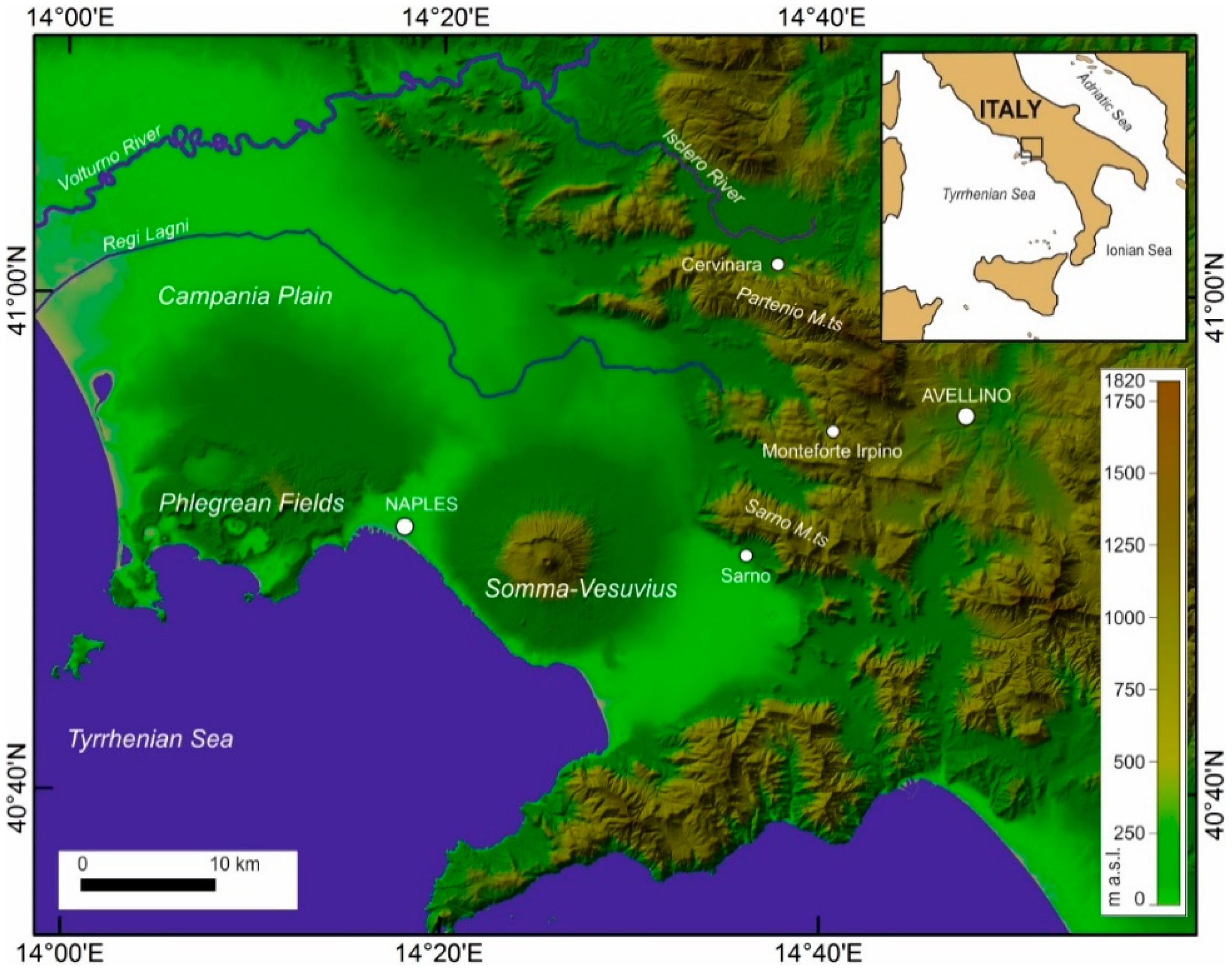
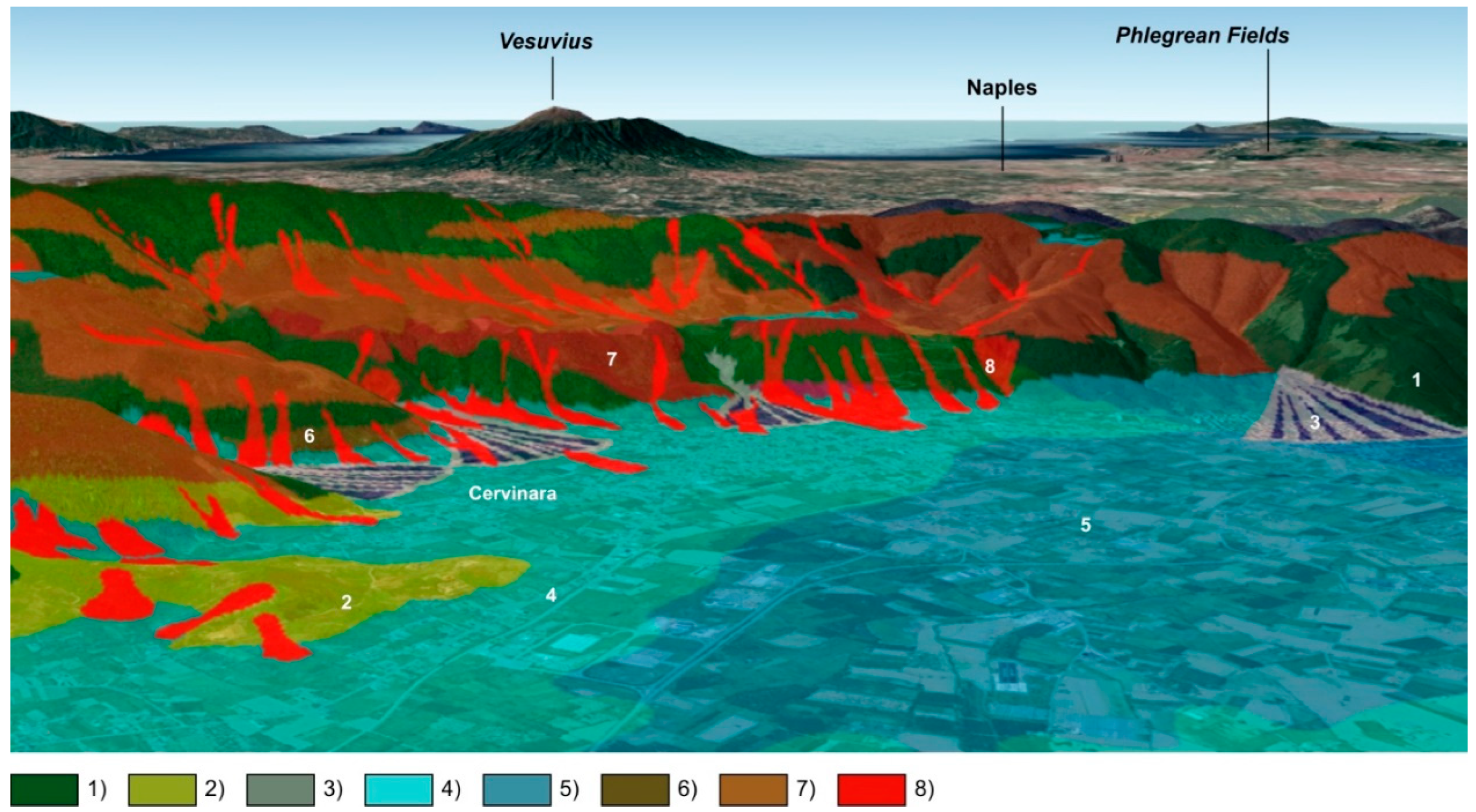
2. Geological Framework of the Cervinara Area

The Cervinara area comprises the Avella Mountains (Partenio group), on the south-eastern border of the Campania Plain, approximately 20 km from the Somma–Vesuvius volcano structure towards the north-east and 40 km from the Phlegrean Fields towards north-east (Figure 1). The mountain range considered is characterized by Meso-Cenozoic limestone and dolomitic limestone that can keep high relief slopes.
Pyroclastic fall materials occur on these reliefs originated from the Phlegrean Fields and Somma–Vesuvius volcanoes [31,32,58]. One of the largest eruptions of the Phlegrean Fields emplaced a significant pyroclastic unit (Campanian Grey Tuff-CGT), which covered the entire Campania Plain and reached also the foot of the Campanian Apennine mountains [31]. Following the beginning of the Somma–Vesuvius activity (about 25 ka BP), ash-fall deposits blanketed the mountains, particularly after the Sarno (17 ka BP; [59]), Ottaviano (8 ka BP; [60]), Avellino (3.5 ka BP; [61]), and Pompeii AD 79 [62], AD 472 [63], AD 1631 [64] and AD 1944 [65] eruptions.
The thickness of the volcaniclastic covers greatly varies across the area and was mainly controlled by weathering and denudational processes over time. In areas with slopes steeper than 28 degrees, the erosional processes can be enhanced up to the complete denudation [66,67]. The presence of the above covers, especially in steeper areas, makes large sectors of the mountain slopes particularly vulnerable to landslides, which can manifest as debris avalanches and rapid earth flows ([68,69] and references therein; Figure 2).

3. Study Criteria

A database was built by selecting the articles in which the covers of the investigated area were described using lithostratigraphic and/or pedological approaches.
The selection was made from national and international scientific journals available through the major online scientific databases, utilizing specific keywords such as Campania landslides, Cervinara landslide, debris flows in pyroclastics, rainfall-induced landslides, landslide susceptibility assessment, pyroclastic distribution on Campania Apennines, and Andisols/Andosols.
Proceedings of national and international conferences, book chapters and grey literature (sensu Rothstein and Hopewell [72]) were generally excluded, unless they included peer review. After collecting over 150 articles, each document was examined to select only those that provided the required arguments. Each article was classified based on the following information: citation (author names/name, title, etc.), type of approach, investigation methods, and any lithostratigraphic and pedological data produced. Articles based on a lithostratigraphic approach were separated from those using a pedological approach. Each category was then further divided into homogeneous groups as possible, organized by authors listed in alphabetical and chronological order. For a better knowledge of the physical context of the study area, a field survey was also conducted by the authors of the present review.
The complete list of papers related to the area in question is reported in Table 1, elaborated following the described criteria. In the following paragraphs, the two mentioned approaches will be examined and the results will be discussed.

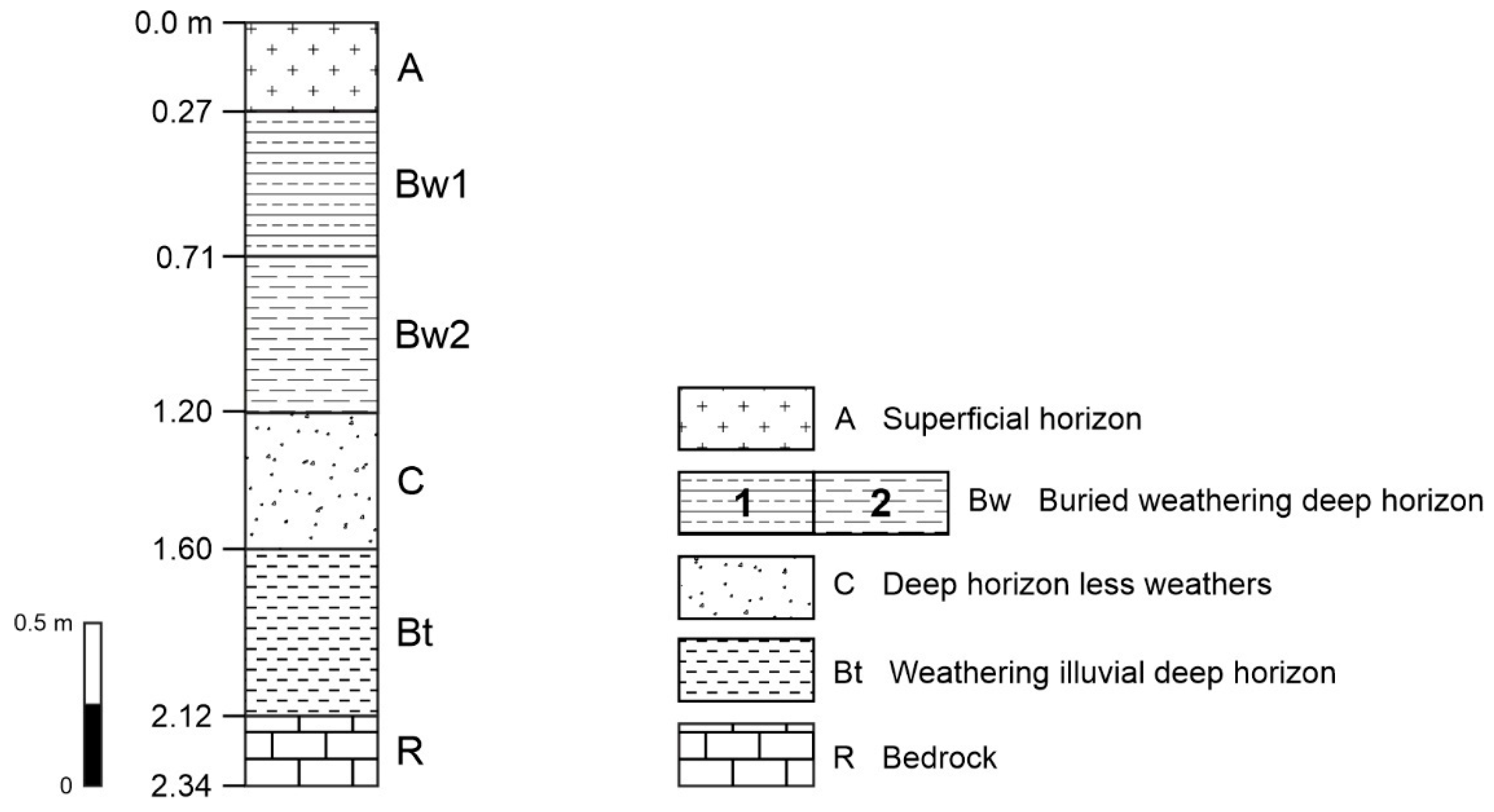
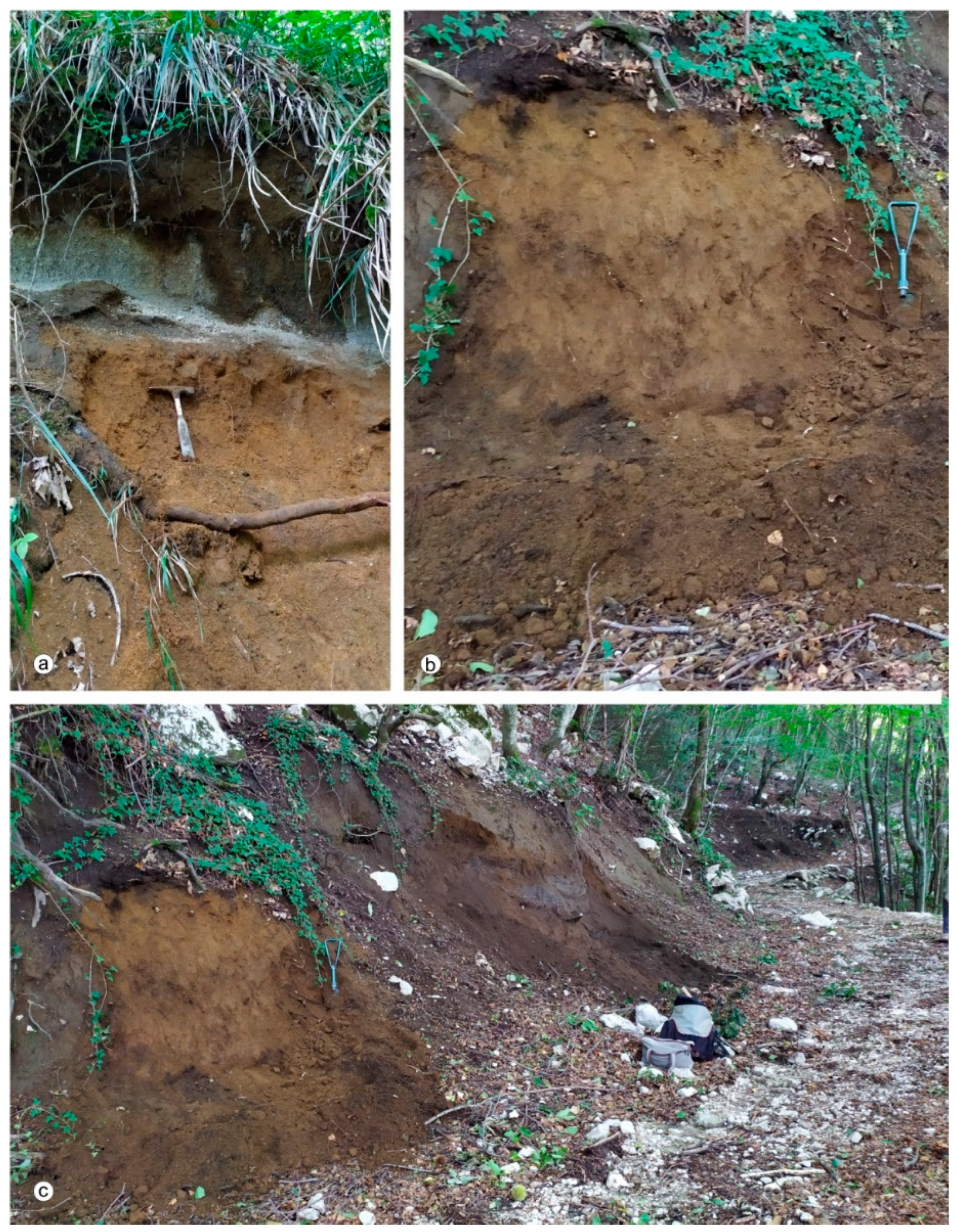
4. Pedological Approach

The pedostratigraphic characteristics of the surficial covers are consistent with the depositional dynamics that have affected the slopes in question and also the extensive areas of the Campania Apennines interacting with the volcanic sediments deposited. The dominance of the volcanic material is evident from the volcanic soil inventory conducted by Terribile et al. [73], which provides a comprehensive description of soil units in the Cervinara area, including Andosols (following WRB) formed by ashes and pumices from the fall deposits of Somma–Vesuvius and Phlegrean Fields volcanoes.
In this scenario, through the investigations using the pedological approach, the soils show a succession of different pedogenized materials, with or without layers of primary pyroclastic deposits, in some cases resting on carbonate rock. Where present, the primary pyroclastic level, interrupting the sequence of pedogenized materials, corresponded to a C soil horizon (Figure 3). This horizon consisted of pumices attributed to the Vesuvian Avellino eruption [75]. It is commonly found throughout the study area, has variable thickness, and contains reworked pumices, as also observed by the authors of this review during the survey conducted in the study area (Figure 4).
Guadagno et al. [79] reported this layer beneath a pedogenetically differentiated soil portion (A and Bw soil horizons) and covering a deep horizon, namely the Bt soil horizon. According to its denomination, this last horizon is characterized by higher content of fine textured mineral component compared to the upper ones, as indicated by the reported results of the grain size analysis. Following Fiorillo et al. [75] and Guadagno et al. [79], this Bt horizon would derive from the alteration of products of the Phlegran Campania Ignimbrite, which represents the oldest source of pyroclastics in the studied area. Consequently, this horizon is expected be more altered than the surface soil, and this can involve a marked discontinuity in physical properties of this soil portion [23]. Additionally, this level in question can also be found without being buried by the Avellino pumice level and shows a good lateral continuity, as revealed by our survey (Figure 5).
Guadagno et al. [76,79] and Revellino et al. [78] also described soil profiles with horizonation similar to those reported previously. However, these profiles are reported not only for Cervinara area but also for Sarno and Quindici and, therefore, making them useful as a reference scheme.
The important reworking activity of the surfaces in question is reported by Fiorillo et al. [75] and Di Crescenzo et al. [82], which showed the obliteration of the original stratification occurring in the studied Apennine environment. This activity is also highlighted by the investigation conducted by Guadagno et al. [76] on the gravitational and colluvial processes characterizing the study area. The resulting effects, such as the abrupt lateral contrast of the covers and chaotic presence of carbonatic blocks on the surface and within the covers, are also observed by the authors of this review and shown in Figure 4. These observations, along with other considerations regarding the gravitational and colluvial processes, are particularly useful for understanding the mechanisms involved in the landslides. These mechanisms are influenced by change in the physical features exhibited by the materials when remolded and reworked [105,106].
As previously reported, the pedogenized horizons are also found not interrupted by pyroclastic materials, as observed in the soil profile studied by Terribile et al. [74], which is located in a site with exposure NE at 825 m a.s.l. The profile in question was laid on carbonatic rock and had a soil horizonation of A-Bw1-Bw2-Ab-Bwb1-Bwb2-pocket-Bwb2-Bwb3-R (Figure 5a). This indicated an organization of the profile in two pedogenetically distinct soil portions, the first consisting of the upper three soil horizons and the deeper portion consisting of four buried soil horizons (Ab and Bwb soil horizons). The absence of C horizons beneath the upper soil portion (Bw1 and Bw2 soil horizons) involved the direct contact of this portion with the buried one. This suggested a possible origin of the upper soil horizons from materials transported from other sites, consistent with the general dynamics of the environment. Evidence of reworking was also provided by the presence, in the buried soil portion, of a pocket of material that breaks the horizontal continuity of the soil and aligned with the recorded transport processes. Additional information about the soil properties is derived from the classification of the profile, according to ST, as a Hapludand, a Great Group the Andisol Order. This classification directly connects the soil to volcanic materials and their alteration products, which, here, are further testified by the content of allophane varying from 0.7 to 24.6%. Moreover, the accommodation of the profile into the Hapludand category provides an indication about the water retention. Specifically, this category excluded that the water retention at saturation (values of water retention, measured as 1500 KPa) did not exceed 15% when soil is air-dried and more than 30% when soil is undried. This information enhances the opportunity to study the covers using pedological criteria because it highlights a property directly involved in the landslide processes triggered by meteoric events. Among the analytical data provided by the authors, it is noteworthy that the highest organic carbon content was found in the upper A horizon (146.7 g/kg). Also, these data are crucial for how soil responds to the meteoric events; in fact, the organic carbon in the uppermost soil portion, which first interacts with the rainwater, contributes to infiltration and drainage processes, either directly or through the formation of structure elements.
A more recent pedological contribution was provided by Carotenuto et al. [80] and Carotenuto and Minale [81]. These studies showed soil profiles with soil horizonation O-A-Bw-2C-3Ab-3Btb (Figure 5b), which is classified as Andic Humudept (mesic, ashy-pumiceous), according to the ST criteria. While the sequence was somewhat similar to that described by the authors of Group B, the latter did not always report the buried A soil horizon and it was different from the soil profile described by Terribile et al. [74]. The soil profile revealed a weaker expression of the andic soil properties with respect to those reported by Terribile et al. [73,74], as highlighted by its collocation in the Inceptisol Order. This difference evidenced the variability of the pedological covers in the studied area. The classification of this soil in the Humudept Great Group indicated that the soil surface is rich in humified organic material, which significantly contributed to the soil aggregation. Consequently, the measure of this soil component is particularly useful in interpreting the behavior of the surfaces in response to the external stresses.
Concerning soil horizonation (A-Bw-2C-3Ab-3Btb), it indicated that the soil had a polygenetic nature, with three steps of formation and related discontinuities. In particular, the discontinuity between the upper soil portion (O-A-Bw soil horizons) and the underlying 2C soil horizon suggested a process of rejuvenation of the surface. This process probably occurred, coherently with the dynamics of the studied environment, due to the deposition of sediments from another site, differing from those in the 2C horizon. Over time, these sediments have contributed to the soil architecture.
It is also interesting to note the presence, in this soil profile, of the 2C horizon because this layer, which was attributed to the fall deposits of the Vesuvian Avellino eruption, is not always recorded in the sections described by other authors. This variability is in accordance with either the natural morphological variations of the carbonate relief or the looseness of the deposits in question, both conditions favoring sediment removal, transport and accumulation in sites different from their original allocation. Further, the buried deep portion retained an A horizon (3Ab) that can constitute useful information in reconstructing the entity of the sedimentary processes affecting the surfaces.

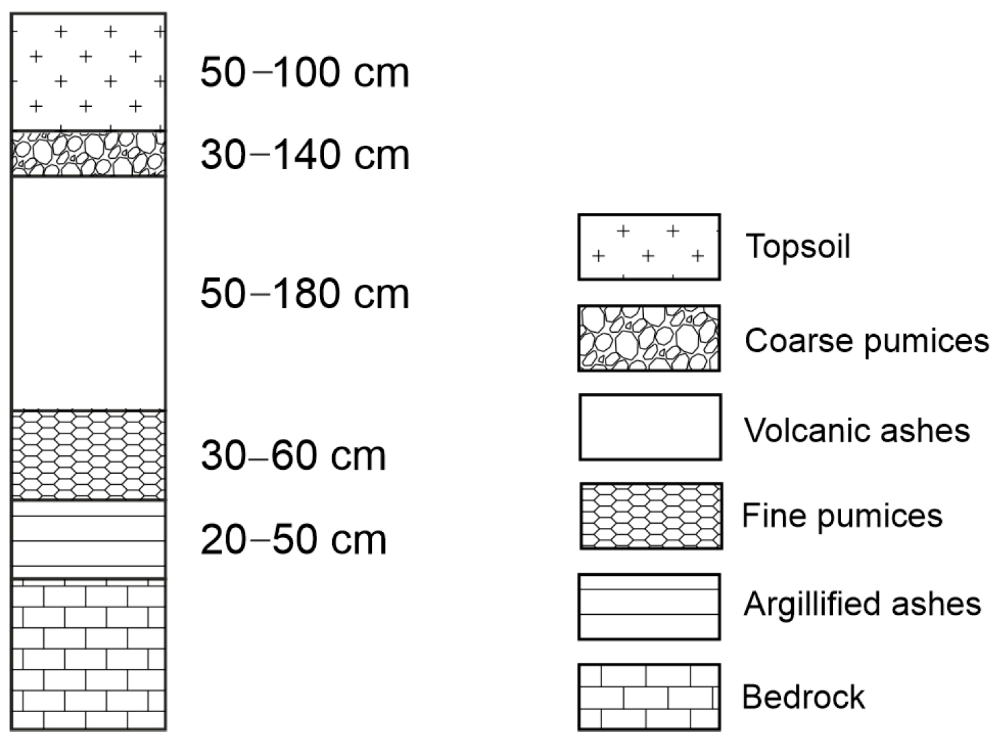
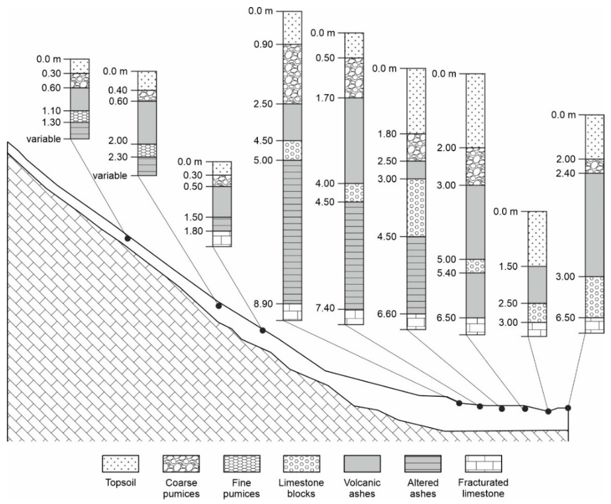
5. Lithostratigraphic Approach

The study of the volcaniclastic covers of the Cervinara area has also involved another group of research that analyzes these deposits strictly from a lithostratigraphic point of view, without referencing pedological tools. These geological investigations are provided by the groups of Authors D and E listed in Table 1. A typical sequence observed through this approach included soil–Avellino pumices–yellowish ignimbritic paleosol-rock. This sequence is illustrated in Di Crescenzo et al. [68], Di Crescenzo et al. [82], and De Riso and Santo [83] but also in Fiorillo et al. [75], who used the pedological nomenclature too, as previously described. The above sequence organization, with a Vesuvian Avellino pumice level separating the upper soil from the paleosol and a yellowish paleosol from Campania Ignimbrite resting on the carbonate rock, confirmed the general stratigraphic pattern observed in Cervinara area. However, this pattern constituted only a portion of the sequences found in the area in question, as shown by the more differentiated sections reported by the authors of the Group E. One of these consisted of top soil–(coarse) pumices–volcanic ashes–(fine) pumices–(weathered) (argillified) altered ashes–(fractured) limestone (carbonatic rock). This sequence was located along a slope equipped with monitoring stations for the hydraulic and geotechnical studies of the materials involved in the landslide processes [51,84,87,88,89,92,93]. To the same pattern, it was similar to the sequence investigated by Picarelli and Vinale [83] on the slopes of the Avella and Partenio Mounts, reporting the following legenda: terreno vegetale (topsoil)–coarse pumices–ashes–fine pumices–clayey pumices–fractured carbonate (Figure 6). This sequence refers to that produced by Di Crescenzo et al. [82], which, nevertheless, registered a unique pumice level on a deep “clayey paleosol”.
On the slopes where the 1999 Cervinara landslide occurred, Picarelli and Vinale [86] presented three detailed stratigraphies (Figure 7) derived from Damiano [85].
In the first two stratigraphies, two levels of pumices, coarse and fine, were present, while, in the stratigraphy located in the lower part of the slope, the bottom level of fine pumices was absent. This latero-vertical variability in the strata, which was supported by the variation in their thickness, was likely due to the already quoted circumstances, such as the change in the slope morphology, the characteristics of the sediments involved in the formation of the covers, and the sediment transport and deposition processes. The variability in question was even more evident comparing these successions to the section consisting of top soil–pumices–volcanic ashes–pumices–altered ashes–carbonatic rock, reported above. On this subject, it is noteworthy that Picarelli e Vinale [86] reported the presence of pediment areas with cover thickness of about 20 m, consisting of reworked pyroclastics with inclusions of coarse carbonatic materials, which further evidenced the effects of the redistribution processes in correspondence with sediment area accumulation.
The stratigraphies depicted in Figure 7 were also reported by Fusco et al. [27] and Greco et al. [100]. The latter study also showed another section with two pumice levels, located in the medium-high portion of the slope. Further, the alternating pumice and ash strata were also reported by Greco et al. [90,96] and Marino et al. [102] in their description of the study area. A detailed stratigraphic trend studied along the same slope, from the top up to about 500 m a.s.l., was shown by Damiano et al. [92] and Urcioli et al. [98]. They described nine sequences (Figure 8) and evidenced that the pyroclastic covers, having a thickness of about 2.4 m, reached a thickness of 10 m at the base of the slope.
The organization of the nine sequences, along the studied slope, showed all components recorded in the sections of Picarelli and Vinale [86], such as top soil–coarse pumices–volcanic ashes–fine pumices–altered ashes–fractured carbonate and, in addition, levels of limestone blocks. In particular, the top soil was defined by the authors as a level consisting of reworked volcanic ashes; under the top soil, a level of coarse pumices was found everywhere, except for the second last sequence at the base of the slope; a level of volcanic ashes was always found; a fine pumice stratum only occurred in the sequences on the higher elevations; a level of the altered ashes was present everywhere, except for the last two sequences at base of the slope. Further, limestone blocks were absent in the first three sequences, at the high-medium portion of the slope. They appeared under the volcanic ashes and above the altered ashes, when the latter were present, and, finally, directly rested on the carbonate rock in the last two sequences at the base of the slope.
The reported stratigraphies indicated that the covers were the result of periodic superimposition of genetically different materials also reworked. In particular, this clearly emerged from the presence of the level of coarse pumices which buried the layer of volcanic ashes and that of the fine pumices covering the altered ashes in the two first sequences, in addition to the stone line, reaching a thickness of 3.5 m, which is recorded in the sequences at the bottom of the slope. This was likely the result of a process dragging coarse blocks along the slopes, apparently contextual with the disappearance of the fine pumices covering the deep altered ash level in the sequences located at the higher elevations. This clearly indicates that the ash level was generated everywhere by processes of colluviation of materials.
By contrast, the upper level of coarse pumices covering the ashes appeared regularly distributed enough and, therefore, it is not excluded that it was in primary deposition. A pumice level occurring in the upper portion of soil profiles in the study area was found also by the authors of Group B and D and these authors attributed it to the fall products of the Vesuvian Avellino eruption. This suggests that the sites in which the pumice level in question is absent could be locally subjected to activities able to remove the pyroclastic material.
A deep horizon, consisting of altered ashes or volcanic ashes, in contact with the carbonate rock, was confirmed to be permanently present, as widely evidenced by the examined literature, except for the extreme sequences located at the base of the slope. Here, at the contact with the carbonate rock, limestone blocks were found, likely of colluvial origin. The persistence of the deep horizon, at least in the sequences where it was registered, indicated that the horizon in question was not significantly affected by truncation produced by erosion processes. In particular, the observation of this portion in other sites of the studied area conducted by other authors (Group B) evidenced that this deep portion is characterized by pedogenetic differentiation (occurrence of Bw or Bt soil horizons). This was in line with the fact that, as widely documented, this deep portion is derived from Phlegrean ignimbritic products that have been buried by new volcanic products only after a long period of time.
Regarding the upper portion of the reported sequences, the top soil tended to thicken towards the base of the slope. There were two possible explanations for this phenomenon. The first was that a higher stability of the surfaces at the base of the slope, facilitating the pedogenetic processes, favored the gradual and regular development of the surface horizons, in the absence of important losses of materials.
The second possible explanation was that, just under the activity, the inclination along the slopes caused a gradual accumulation of materials from the higher elevations to the lower sites, which, therefore, recorded increments in their upper portions. The prevalence of one or the other circumstance can differently influence the pedogenetic pathway and outcome. In fact, while the first case is an expression of a residual process, in the second case, a sedimentogenic activity is the main driver of the upper cover construction, with related differences in soil properties. With reference to this upper portion, the investigations conducted in the area in question from other authors (Groups A, B and C) showed the presence of an A soil horizon and one or two Bw soil horizons [74,75,77,79,80,81]. This suggests that the variations in the content, quality and distribution of both organic and mineral components and the related implications on hydraulic, geotechnical and rheological characteristics are those generally associated with a regular pedogenetic differentiation.
Sequences obtained during the realization of monitoring stations in the medium-high portion of the slope, which substantially reproduce the layer organization described in Damiano et al. [92] and Urcioli et al. [98], are also reported by Comegna et al. [94,97,104], Greco et al. [95,96] and Damiano [27].

6. Discussion and Conclusions

The analysis of the articles presented in this review provides first evidence of the different approaches to the study of shallow landslides involving soils of pyroclastic origin, focused on the Cervinara area. The main investigations concerned geological, pedological and hydraulic–geotechnical aspects.
The first result of the analysis highlights the extreme variability of the soil cover architecture in the studied environments. This variability arose from the intrinsic diversity of the deposited volcanic sediments as well as the ongoing reworking of both primary and pedogenized materials. On the other hand, however, the variability seen in the data, also affecting the stratigraphic organization, was extremely site-dependent, making it poorly reproducible in terms of a reference sequence for subjected experimental investigations. This issue is testified by the numerous different sections reported in the aforementioned articles, mainly referring to the same sites.
Among the latter, the stratigraphic approach was used in all the hydraulic and geotechnical investigations, while the pedological tools were mainly used in the literature exploiting the physical environment of the study area, even in studies concerning the geological and hydrogeological point of view.
The most evident aspect of the analysis performed in this study was the great diversity in the nomenclature used to describe the strata of the sequences when the lithostratigraphic approach is used. This makes the comparison between the sequences difficult. This is not the case, on the contrary, when pedological criteria were adopted, since the application of the nomenclature is very rigorous. In this case, the use of the pedological approach offered the advantage of highlighting the genetic relationships among the soil horizons, the possible evolution processes undergone by material involved in the cover formation, and the soil properties that can be deduced also resorting to the tools provided by the soil classification systems. The only possible limitation of this approach consisted sometimes in the thickness to which soils are explored, which could constitute an important factor interpreting the impact of the soil properties on the reworking processes.
Above all, the selected literature has shown that most of the studies were mainly focused on hydraulic and geotechnical investigations, documenting an attempt to interpret the role that the considered soils play in triggering the landslide processes, aimed at risk mitigation and the identification of early warning systems.
The pedological approach represented only 31.5% of the studies reviewed, despite its high exploration potential, which should stimulate its broader application in dynamic and complex areas like those investigated. Moreover, it seems singular that most of the studies have focused on a single landslide body, even though a high number of landslide phenomena have been identified in the Cervinara area. The lateral–vertical variability of the covers observed in this area suggested that the approaches used in this review should be extended to include wider outcrops and landslide bodies to verify whether the conclusions acquired were more extensively applicable and contributed to the identification of the best early warning systems criteria.
In fact, analyzing the literature related to neighboring Apennine areas, characterized by a similar geological–geomorphological context and affected by the same landslide phenomena, the same dichotomy in the approach to the study is highlighted. For the area of Sarno and its surroundings, for example, known for the 1998 event that caused over a hundred deaths, a large number of studies are available mainly focused on the examination of the stratigraphic–lithological organization of the slopes affected by the landslide events [82,83,98,107,108,109,110,111,112,113,114], among others. In most of the articles, the reconstructed stratigraphies are difficult to correlate due to the lack of reference markers. In addition to this, the difficulty of identifying the levels made up of reworked materials, very widespread along the slopes, combined with the compositional diversity of the various volcanic events responsible for the production of the fallen material make the lateral–vertical variability of the sequences extremely complex.
Even in these areas, however, the reconstruction carried out by adopting a pedological approach provided profiles showing a clear multi-layered organization, extensively detected by different authors, independently of the location [23,25,73,115,116,117,118,119], among others. What can be deduced is that, despite the difficulty of correlating purely lithostratigraphic reconstructions, the characterization of the pedogenetic horizons allowed us to understand the different extent and effectiveness of the pedogenesis processes and also to highlight any episodes of remodeling and/or removal, thus providing useful information on the genetic relationships between the various sequences described.
More generally, considering the importance of soil architecture and properties in the investigation of the landslide mechanisms, the challenge is to find the keys for the delimitation of landscape units where the factors would converge to form soils as similar as possible.
Landslides are a common natural phenomenon in the Mediterranean and have been recognized as a significant driving force behind the increasing process of land degradation [120,121]. Despite their growing recurrence, these events have often been studied using isolated approaches [122], either the traditional lithostratigraphic or the pedological techniques. The international debate pushes towards an integrated approach that provides a comprehensive inventory of local data and can help predict future risks and inform land use policies. In recent years, this methodology has been proposed as part of Best Practice Guidance to support Sustainable Development Goal 15.3.1 (SDG; [123]) listed in the UN 2030 Agenda for Sustainable Development. This specific goal aims to combat desertification, restore degraded soils and lands, and strive to achieve Land Degradation Neutrality (LDN) in areas affected by desertification, drought and floods (LDN; [124]). Achieving the LDN goal requires the evaluation of indicators that monitor the “proportion of degraded land in relation to the total area”. In addition to well-known indicators, such as vegetation productivity, changes in land cover, and fluctuations in soil organic carbon proposed by the UN Convention to Combat Desertification (UNCCD, 1994), local indicators like landslides have recently been identified, along with fires and drought areas, as useful metrics for evaluating categories of land degradation [122]. According to the UNCCD, the development of local indicators should be promoted in Land Degradation Neutrality (LDN) assessments.
In this regard, our review, which provides historical data on landslides in an area particularly affected by this phenomenon, could be crucial. The proposed approach, which integrated lithostratigraphic and pedological methodologies, highlights the key role of land cover identified, clarifying the mechanisms of land degradation and allowing monitoring systems to be improved, preventing and reducing the impacts of landslides, supporting risk mitigation policies, and contributing to achieving the goals of Land Degradation Neutrality.

Author Contributions

Conceptualization, A.E.; methodology, A.E. and D.R.; software, M.V. and C.B.; validation, A.E., M.V., R.M. and C.B.; investigation, A.E.; resources, A.E.; data curation, A.E., D.R. and R.M.; writing—original draft preparation A.E.; writing—review and editing, A.E., D.R., C.B. and R.M.; visualization, M.V.; supervision, A.E. and D.R. All authors have read and agreed to the published version of the manuscript.

Funding

This work has been developed within the SEND intra-university project, financed by the “V:ALERE 2019” funds (VAnviteLli pEr la RicErca) by the University of Campania “L. Vanvitelli” (Grant ID: B68D19001880005).

Data Availability Statement

Data sharing is not applicable to this article. The datasets 527 presented herein are not readily available because they are part of an ongoing study.

Acknowledgments

The authors acknowledge the insightful comments of the reviewers that have considerably improved the manuscript. The author Antonella Ermice passed away soon after the manuscript was accepted. This contribution is the result of her studies on the volcanic soils of Campania and her enthusiasm for this research.

Conflicts of Interest

The authors declare no conflicts of interest. The funders had no role in the design of the study; in the collection, analyses, or interpretation of data; in the writing of the manuscript, or in the decision to publish the results.

References

  1. Herath, S.; Wang, Y. Case Studies and National Experiences. In Landslides—Disaster Risk Reduction; Sassa, K., Canuti, P., Eds.; Springer: Berlin/Heidelberg, Germany, 2009; pp. 475–497. [Google Scholar]
  2. Petley, D. Global Patterns of Loss of Life from Landslides. Geology 2012, 40, 927–930. [Google Scholar] [CrossRef]
  3. Pereira, S.; Zêzere, J.L.; Quaresma, I.; Santos, P.P.; Santos, M. Mortality Patterns of Hydro-Geomorphologic Disasters. Risk Anal. 2016, 36, 1188–1210. [Google Scholar] [CrossRef] [PubMed]
  4. Froude, M.J.; Petley, D.N. Global Fatal Landslide Occurrence from 2004 to 2016. Nat. Hazards Earth Syst. Sci. 2018, 18, 2161–2181. [Google Scholar] [CrossRef]
  5. García-Ruiz, J.M.; Beguería, S.; Arnáez, J.; Sanjuán, Y.; Lana-Renault, N.; Gómez-Villar, A.; Álvarez-Martínez, J.; Coba-Pérez, P. Deforestation Induces Shallow Landsliding in the Montane and Subalpine Belts of the Urbión Mountains, Iberian Range, Northern Spain. Geomorphology 2017, 296, 31–44. [Google Scholar] [CrossRef]
  6. Stock, J.; Dietrich, W.E. Valley Incision by Debris Flows: Evidence of a Topographic Signature. Water Resour. Res. 2003, 39, 1089. [Google Scholar] [CrossRef]
  7. Gabet, E.J.; Dunne, T. A Stochastic Sediment Delivery Model for a Steep Mediterranean Landscape. Water Resour. Res. 2003, 39, 1237. [Google Scholar] [CrossRef]
  8. Heaphy, M.J.; Lowe, D.J.; Palmer, D.J.; Jones, H.S.; Gielen, G.J.; Oliver, G.R.; Pearce, S.H. Assessing Drivers of Plantation Forest Productivity on Eroded and Non-Eroded Soils in Hilly Land, Eastern North Island, New Zealand. N. Z. J. For. Sci. 2014, 44, 24. [Google Scholar] [CrossRef]
  9. Aleotti, P.; Chowdhury, R. Landslide Hazard Assessment: Summary Review and New Perspectives. Bull. Eng. Geol. Environ. 1999, 58, 21–44. [Google Scholar] [CrossRef]
  10. van Westen, C.J.; Rengers, N.; Soeters, R. Use of Geomorphological Information in Indirect Landslide Susceptibility Assessment. Nat. Hazards 2003, 30, 399–419. [Google Scholar] [CrossRef]
  11. Cascini, L. Applicability of Landslide Susceptibility and Hazard Zoning at Different Scales. Eng. Geol. 2008, 102, 164–177. [Google Scholar] [CrossRef]
  12. Corominas, J.; van Westen, C.; Frattini, P.; Cascini, L.; Malet, J.P.; Fotopoulou, S.; Catani, F.; Van Den Eeckhaut, M.; Mavrouli, O.; Agliardi, F.; et al. Recommendations for the Quantitative Analysis of Landslide Risk. Bull. Eng. Geol. Environ. 2014, 73, 209–263. [Google Scholar] [CrossRef]
  13. Alcántara-Ayala, I.; Sassa, K. Landslide Risk Management: From Hazard to Disaster Risk Reduction. Landslides 2023, 20, 2031–2037. [Google Scholar] [CrossRef]
  14. Haque, U.; da Silva, P.F.; Devoli, G.; Pilz, J.; Zhao, B.; Khaloua, A.; Wilopo, W.; Andersen, P.; Lu, P.; Lee, J.; et al. The Human Cost of Global Warming: Deadly Landslides and Their Triggers (1995–2014). Sci. Total Environ. 2019, 682, 673–684. [Google Scholar] [CrossRef] [PubMed]
  15. Bezak, N.; Mikoš, M. Changes in the Rainfall Event Characteristics above the Empirical Global Rainfall Thresholds for Landslide Initiation at the Pan-European Level. Landslides 2021, 18, 1859–1873. [Google Scholar] [CrossRef]
  16. Cohen, D.; Schwarz, M. Tree-Root Control of Shallow Landslides. Earth Surf. Dyn. 2017, 5, 451–477. [Google Scholar] [CrossRef]
  17. Murgia, I.; Giadrossich, F.; Mao, Z.; Cohen, D.; Capra, G.F.; Schwarz, M. Modeling Shallow Landslides and Root Reinforcement: A Review. Ecol. Eng. 2022, 181, 106671. [Google Scholar] [CrossRef]
  18. Zhang, J.; Qiu, H.; Tang, B.; Yang, D.; Liu, Y.; Liu, Z.; Ye, B.; Zhou, W.; Zhu, Y. Accelerating Effect of Vegetation on the Instability of Rainfall-Induced Shallow Landslides. Remote Sens. 2022, 14, 5743. [Google Scholar] [CrossRef]
  19. Asada, H.; Minagawa, T. Impact of Vegetation Differences on Shallow Landslides: A Case Study in Aso, Japan. Water 2023, 15, 3193. [Google Scholar] [CrossRef]
  20. Li, Y.; Duan, W. Decoding Vegetation’s Role in Landslide Susceptibility Mapping: An Integrated Review of Techniques and Future Directions. Biogeotechnics 2024, 2, 100056. [Google Scholar] [CrossRef]
  21. Amato, M.; Di Martino, P.; Di Pasquale, G.; Mazzoleni, S.; Migliozzi, A.; Strumia, S. Il Ruolo Della Vegetazione Nelle Frane Di Quindici. Quad. Geol. Appl. 2000, 7, 97–108. [Google Scholar]
  22. Dai, C.; Wang, T.; Zhou, Y.; Deng, J.; Li, Z. Hydraulic Properties in Different Soil Architectures of a Small Agricultural Watershed: Implications for Runoffgeneration. Water 2019, 11, 2537. [Google Scholar] [CrossRef]
  23. Basile, A.; Mele, G.; Terribile, F. Soil Hydraulic Behaviour of a Selected Benchmark Soil Involved in the Landslide of Sarno 1998. Geoderma 2003, 117, 331–346. [Google Scholar] [CrossRef]
  24. Mirus, B.B. Evaluating the Importance of Characterizing Soil Structure and Horizons in Parameterizing a Hydrologic Process Model. Hydrol. Process. 2015, 29, 4611–4623. [Google Scholar] [CrossRef]
  25. Fusco, F.; Allocca, V.; De Vita, P. Hydro-Geomorphological Modelling of Ash-Fall Pyroclastic Soils for Debris Flow Initiation and Groundwater Recharge in Campania (Southern Italy). Catena 2017, 158, 235–249. [Google Scholar] [CrossRef]
  26. Fusco, F.; Mirus, B.; Baum, R.; Calcaterra, D.; De Vita, P. Incorporating the Effects of Complex Soil Layering and Thickness Local Variability into Distributed Landslide Susceptibility Assessments. Water 2021, 13, 713. [Google Scholar] [CrossRef]
  27. Damiano, E. Effects of Layering on Triggering Mechanisms of Rainfall-Induced Landslides in Unsaturated Pyroclastic Granular Soils. Can. Geotech. J. 2019, 56, 1278–1290. [Google Scholar] [CrossRef]
  28. Hübner, R.; Günther, T.; Heller, K.; Noell, U.; Kleber, A. Impacts of a Capillary Barrier on Infiltration and Subsurface Stormflow in Layered Slope Deposits Monitored with 3-D ERT and Hydrometric Measurements. Hydrol. Earth Syst. Sci. 2017, 21, 5181–5199. [Google Scholar] [CrossRef]
  29. Terribile, F.; Basile, A.; Bonfante, A.; Carbone, A.; Colombo, C.; Langella, G.; Iamarino, M.; Manna, P.; Minieri, L.; Vingiani, S. Future Soil Issues. In The soils of Italy; Springer: Berlin/Heidelberg, Germany, 2013; pp. 303–348. [Google Scholar]
  30. Hartemink, A.E. Into the Pedocene—Pedology of a Changing World. Eur. J. Soil Sci. 2023, 74, e13399. [Google Scholar] [CrossRef]
  31. Rolandi, G.; De Natale, G.; Kilburn, C.R.J.; Troise, C.; Somma, R.; Di Lascio, M.; Fedele, A.; Rolandi, R. The 39 Ka Campanian Ignimbrite Eruption: New Data on Source Area in the Campanian Plain. In Vesuvius, Campi Flegrei, and Campanian Volcanism; De Vivo, B., Belkin, H.E., Rolandi, G., Eds.; Elsevier: Amsterdam, The Netherlands, 2020; pp. 175–205. ISBN 9780128164549. [Google Scholar]
  32. Ruberti, D.; Vigliotti, M.; Rolandi, R.; Di Lascio, M. Effect of Paleomorphology on Facies Distribution of the Campania Ignimbrite in the Northern Campania Plain, Southern Italy. In Vesuvius, Campi Flegrei, and Campanian Volcanism; De Vivo, B., Belkin, H., Rolandi, G., Eds.; Elsevier: Amsterdam, The Netherlands, 2020; pp. 207–229. ISBN 9780128164549. [Google Scholar]
  33. Celico, P.; Guadagno, F. Le Instabilità Delle Coltri Piroclastiche Delle Dorsali Carbonatiche in Campania: Attuali Conoscenze. Quad. Geol. Appl. 1998, 5, 73–133. [Google Scholar]
  34. Ermice, A. A Pedological Case Study of Volcanoclastically Impacted Landscapes: The Vesuvian Avellino Air-Fall Deposits, Southern Italy. CATENA 2017, 149, 241–252. [Google Scholar] [CrossRef]
  35. Ermice, A.; Pugliano, M.; Murolo, M.; Buondonno, A.; Flaminio, G.; Buondonno, C. Volcanic Ejecta as Soil Forming Factor on Carbonate Relieves of the Partenio Mountain (Campanian Apennines). Boll. DELLA Soc. Geol. Ital. 1999, 118, 505–511. [Google Scholar]
  36. Ermice, A.; Marzaioli, R.; Vigliotti, M.; Lamberti, P.; Ruberti, D. Soils in Understanding Land Surface Construction: An Example from Campania Plain, Southern Italy. Quaternary 2024, 7, 39. [Google Scholar] [CrossRef]
  37. Babiera, V.V.; Takahashi, T. Characteristics of Soils Derived from Tephra and Pyroclastic Flow Deposits from Taal Volcano, the Philippines. Soil Sci. Plant Nutr. 1997, 43, 763–776. [Google Scholar] [CrossRef]
  38. Lowe, D.J.; Palmer, D.J. Andisols of New Zealand and Australia. J. Integr. F. Sci. 2005, 2, 39–65. [Google Scholar]
  39. Arifin, M.; Devnita, R.; Anda, M.; Goenadi, D.H.; Nugraha, A. Characteristics of Andisols Developed from Andesitic and Basaltic Volcanic Ash in Different Agro-Climatic Zones. Soil Syst. 2022, 6, 78. [Google Scholar] [CrossRef]
  40. Zakharikhina, L.V. Soil Formation on Acid and Basic Volcanic Ashes of Different Ages in Kamchatka. Eurasian Soil Sci. 2006, 39, 938–952. [Google Scholar] [CrossRef]
  41. Navarrete, I.A.; Tsutsuki, K.; Kondo, R.; Asio, V.B. Genesis of Soils across a Late Quaternary Volcanic Landscape in the Humid Tropical Island of Leyte, Philippines. Aust. J. Soil Res. 2008, 46, 403–414. [Google Scholar] [CrossRef]
  42. Tonneijck, F.H.; Hageman, J.A.; Sevink, J.; Verstraten, J.M. Tephra Stratification of Volcanic Ash Soils in Northern Ecuador. Geoderma 2008, 144, 231–247. [Google Scholar] [CrossRef]
  43. Lowe, D.J.; Lanigan, K.M.; Palmer, D.J. Where Geology Meets Pedology: Late Quaternary Tephras, Loess, and Paleosols in the Mamaku Plateau and Lake Rerewhakaaitu Areas. In Field Trip Guides, Geosciences 2012 Conference, Hamilton, New Zealand; Pittari, A. (Compiler) Geoscience Society of New Zealand Miscellaneous Publication: Newtown, WLG, New Zeland, 2021; pp. 2.1–2.45. ISBN 978-1-877480-26-3. ISSN (online): 2230-4487. [Google Scholar]
  44. Shimizu, O.; Ono, M. Relationship of Tephra Stratigraphy and Hydraulic Conductivity with Slide Depth in Rainfall-Induced Shallow Landslides in Aso Volcano, Japan. Landslides 2016, 13, 577–582. [Google Scholar] [CrossRef]
  45. Lowe, D.J. Using Soil Stratigraphy and Tephrochronology to Understand the Origin, Age, and Classification of a Unique Late Quaternary Tephra-Derived Ultisol in Aotearoa New Zealand. Quaternary 2019, 2, 9. [Google Scholar] [CrossRef]
  46. Nurcholis, M.; Herlambang, S.; Suwartikaningsih, S.A.; Fiantis, D.; Yudiantoro, D.F. Soil Layers Properties of a Profile Developed on the Past Depositional Series on Merbabu Volcano Central Java Indonesia. J. Trop. Soils 2019, 24, 53. [Google Scholar] [CrossRef]
  47. Arata, Y.; Gomi, T.; Sidle, R.C. Topographic Features and Stratified Soil Characteristics of a Hillslope with Fissures Formed by the 2016 Kumamoto Earthquake. Geoderma 2020, 376, 114547. [Google Scholar] [CrossRef]
  48. Shoji, S.; Dahlgren, R.; Nanzyo, M. Classification of Volcanic Ash Soils. Volcan. Ash Soils 1993, 21, 73–100. [Google Scholar]
  49. Temme, A.J.A.M. Relations Between Soil Development and Landslides. In Hydrogeology, Chemical Weathering, and Soil Formation; Hunt, H., Egli, M., Faybishenko, B., Eds.; Book Series: Geophysical Monograph Series; American Geophysical Union: Washington, DC, USA, 2021; pp. 177–185. ISBN 9781119563952. [Google Scholar] [CrossRef]
  50. Delvoie, M.; Delmelle, P.; Rattez, H.; Pereira, J.-M.; Tang, A.M. Hydraulic and Mechanical Behaviour of Volcanic Soils and Implications for Evaluating Slope Stability. In Proceedings of the EGU General Assembly 2023, Vienna, Austria, 24–28 April 2023. [Google Scholar]
  51. Picarelli, L.; Evangelista, A.; Rolandi, G. Mechanical Properties of Pyroclastic Soils in Campania Region. In Proceedings of the 2nd International Workshop on Characterisation and Engineering Properties of Natural Soils, Singapore, 5–7 December 2006; Volume 4, pp. 2331–2384. [Google Scholar]
  52. Bartoli, F.; Regalado, C.M.; Basile, A.; Buurman, P.; Coppola, A. Physical Properties in European Volcanic Soils: A Synthesis and Recent Developments. In Soils of Volcanic Regions in Europe; Arnalds, Ó., Óskarsson, H., Bartoli, F., Buurman, P., Stoops, G., García-Rodeja, E., Eds.; Springer: Berlin/Heidelberg, Germany, 2007; pp. 515–537. ISBN 3540487107. [Google Scholar]
  53. Soil Survey Staff. Keys to Soil Taxonomy, 13th ed.; Natural Resources Conservation Service: Washington, DC, USA, 2022; ISBN 0926487221.
  54. IUSS Working Group WRB. World Reference Base for Soil Resources. In International Soil Classification System for Naming Soils and Creating Legends for Soil Maps, 4th ed.; International Union of Soil Sciences (IUSS): Vienna, Austria, 2022. [Google Scholar]
  55. Fusco, F.; Tufano, R.; De Vita, P.; Di Martire, D.; Di Napoli, M.; Guerriero, L.; Mileti, F.A.; Terribile, F.; Calcaterra, D. A Revised Landslide Inventory of the Campania Region (Italy). Sci. Data 2023, 10, 355. [Google Scholar] [CrossRef]
  56. IFFI—Inventario dei Fenomeni Franosi in Italia. Available online: https://www.isprambiente.gov.it/it/progetti/cartella-progetti-in-corso/suolo-e-territorio-1/iffi-inventario-dei-fenomeni-franosi-in-italia (accessed on 3 December 2024).
  57. IdroGEO. Available online: https://idrogeo.isprambiente.it/app/ (accessed on 3 December 2024).
  58. Rolandi, G.; Di Lascio, M.; Rolandi, R. The Neapolitan Yellow Tuff Eruption as the Source of the Campi Flegrei Caldera. In Vesuvius, Campi Flegrei, and Campanian Volcanism; Elsevier: Amsterdam, The Netherlands, 2020; pp. 273–296. ISBN 9780128164549. [Google Scholar]
  59. Rolandi, G.; Bertollini, F.; Cozzolino, G.; Esposito, N.; Sannino, D. Sull’origine Delle Coltri Piroclastiche Presenti Sul Versante Occidentale Del Pizzo d’Alvano (Sarno-Campania). Quad. Geol. Appl. 2000, 7, 37–48. [Google Scholar]
  60. Rolandi, G.; Maraffi, S.; Petrosino, P.; Lirer, L. The Ottaviano Eruption of Somma-Vesuvio (8000 y B.P.): A Magmatic Alternating Fall and Flow-Forming Eruption. J. Volcanol. Geotherm. Res. 1993, 58, 43–65. [Google Scholar] [CrossRef]
  61. Rolandi, G.; Mastrolorenzo, G.; Barrella, A.M.; Borrelli, A. The Avellino Plinian Eruption of Somma-Vesuvius (3760 y.B.P.): The Progressive Evolution from Magmatic to Hydromagmatic Style. J. Volcanol. Geotherm. Res. 1993, 58, 67–88. [Google Scholar] [CrossRef]
  62. Lirer, L.; Pescatore, T.; Booth, B.; Walker, G.P.L. Two Plinian Pumice-Fall Deposits from Somma-Vesuvius, Italy. Bull. Geol. Soc. Am. 1973, 84, 759–772. [Google Scholar] [CrossRef]
  63. Rolandi, G.; Petrosino, P.; Mc Geehin, J. The Interplinian Activity at Somma-Vesuvius in the Last 3500 Years. J. Volcanol. Geotherm. Res. 1998, 82, 19–52. [Google Scholar] [CrossRef]
  64. Rosi, M.; Principe, C.; Vecci, R. The 1631 Vesuvius Eruption. A Reconstruction Based on Historical and Stratigraphical Data. J. Volcanol. Geotherm. Res. 1993, 58, 151–182. [Google Scholar] [CrossRef]
  65. Cole, P.D.; Scarpati, C. The 1944 Eruption of Vesuvius, Italy: Combining Contemporary Accounts and Field Studies for a New Volcanological Reconstruction. Geol. Mag. 2010, 147, 391–415. [Google Scholar] [CrossRef]
  66. De Vita, P.; Agrello, D.; Ambrosino, F. Landslide Susceptibility Assessment in Ash-Fall Pyroclastic Deposits Surrounding Mount Somma-Vesuvius: Application of Geophysical Surveys for Soil Thickness Mapping. J. Appl. Geophys. 2006, 59, 126–139. [Google Scholar] [CrossRef]
  67. De Vita, P.; Nappi, M. Regional Distribution of Ash-Fall Pyroclastic Soils for Landslide Susceptibility Assessment. Landslide Sci. Pract. Spat. Anal. Model. 2013, 3, 103–109. [Google Scholar] [CrossRef]
  68. Di Crescenzo, G.; Santo, A. Debris Slides-Rapid Earth Flows in the Carbonate Massifs of the Campania Region (Southern Italy): Morphological and Morphometric Data for Evaluating Triggering Susceptibility. Geomorphology 2005, 66, 255–276. [Google Scholar] [CrossRef]
  69. Del Soldato, M.; Pazzi, V.; Segoni, S.; De Vita, P.; Tofani, V.; Moretti, S. Spatial Modeling of Pyroclastic Cover Deposit Thickness (Depth to Bedrock) in Peri-Volcanic Areas of Campania (Southern Italy). Earth Surf. Process. Landf. 2018, 43, 1757–1767. [Google Scholar] [CrossRef]
  70. Carannante, G.; Cesarano, M.; Pappone, G.; Putignano, M.L. Note Illustrative Della Carta Geologica d’Italia in Scala 1:50.000, Foglio n. 431; Caserta Est. Servizio Geologico d’Italia (ISPRA): Rome, Italy, 2012. Available online: https://www.isprambiente.gov.it/Media/carg/note_illustrative/431_Caserta_est.pdf (accessed on 3 December 2024).
  71. Trigila, A. (Ed.) Rapporto Sulle Frane in Italia. Il Progetto IFFI: Metodologia, Risultati e Rapporti Regionali; Rapporti 78/2007; APAT—Agenzia per la Protezione dell’Ambiente e per i Servizi Tecnici: Rome, Italy, 2007; ISBN 978-88-448-0310-0. [Google Scholar]
  72. Rothstein, H.R.; Hopewell, S. Grey Literature. In The Handbook of Research Synthesis and Meta-Analysis; Cooper, H., Hedges, L.V., Valentine, J.C., Eds.; Russell Sage Foundation: New York, NY, USA, 2009; pp. 103–125. ISBN 9781610448864. [Google Scholar]
  73. Terribile, F.; Di Gennaro, A.; Aronne, G.; Basile, A.; Buonanno, M.; Mele, G.; Vingiani, S. I Suoli Delle Aree Di Crisi Di Quindici e Sarno: Proprietà e Comportamenti in Relazione Ai Fenomeni Franosi Del 1998. Quad. Geol. Appl. 2000, 7, 81–95. [Google Scholar]
  74. Terribile, F.; Basile, A.; De Mascellis, R.; Iamarino, M.; Magliulo, P.; Pepe, S.; Vingiani, S. Landslide processes and Andosols: The case study of the Campania region, Italy. In Soils of Volcanic Regions in Europe; Arnalds, O., Bartoli, F., Buurman, P., Oskarsson, H., Stoops, G., García-Rodeja, E., Eds.; Springer: Berlin/Heidelberg, Germany, 2007; pp. 545–563. [Google Scholar] [CrossRef]
  75. Fiorillo, F.; Guadagno, F.; Aquino, S.; De Blasio, A. The December 1999 Cervinara Landslides: Further Debris Flows in the Pyroclastic Deposits of Campania (Southern Italy). Bull. Eng. Geol. Environ. 2001, 60, 171–184. [Google Scholar] [CrossRef]
  76. Guadagno, F.M.; Martino, S.; Scarascia Mugnozza, G. Influence of Man-Made Cuts on the Stability of Pyroclastic Covers (Campania, Southern Italy): A Numerical Modelling Approach. Environ. Geol. 2003, 43, 371–384. [Google Scholar] [CrossRef]
  77. Fiorillo, F.; Wilson, R.C. Rainfall Induced Debris Flows in Pyroclastic Deposits, Campania (Southern Italy). Eng. Geol. 2004, 75, 263–289. [Google Scholar] [CrossRef]
  78. Revellino, P.; Hungr, O.; Guadagno, F.M.; Evans, S.G. Velocity and Runout Simulation of Destructive Debris Flows and Debris Avalanches in Pyroclastic Deposits, Campania Region, Italy. Environ. Geol. 2004, 45, 295–311. [Google Scholar] [CrossRef]
  79. Guadagno, F.M.; Forte, R.; Revellino, P.; Fiorillo, F.; Focareta, M. Some Aspects of the Initiation of Debris Avalanches in the Campania Region: The Role of Morphological Slope Discontinuities and the Development of Failure. Geomorphology 2005, 66, 237–254. [Google Scholar] [CrossRef]
  80. Carotenuto, C.; Merola, M.C.; Álvarez-Romero, M.; Coppola, E.; Minale, M. Rheology of Natural Slurries Involved in a Rapid Mudflow with Different Soil Organic Carbon Content. Colloids Surf. A Physicochem. Eng. Asp. 2015, 466, 57–65. [Google Scholar] [CrossRef]
  81. Carotenuto, C.; Minale, M. Effect of the Soil Organic Content on Slurries Involved in Mudflows. Procedia Earth Planet. Sci. 2016, 16, 89–97. [Google Scholar] [CrossRef]
  82. Di Crescenzo, G.; Rotella, M.; Santo, A. Il Contributo della Geologia per lo Studio dei Meccanismi di Innesco di Colate Rapide di Fango al Campo Sperimentale di Monteforte Irpino (AV). In Piattaforme Evolute di Telecomunicazioni e di Information Technology per l’Offerta di Servizi al Settore Ambiente, Progetto PETIT-OSA; Aracne Edizioni: Rome, Italy, 2007; pp. 263–272. [Google Scholar]
  83. de Riso, R.; Santo, A. I contesti geologici e le caratteristiche delle colate di fango. In Un Laboratorio Integrato Finalizzato Allo Studio Delle Colate di Fango in Terreni Piroclastici; Picarelli, L., Vinale, F., Eds.; AMRA: Naples, Italy, 2009; pp. 11–22. [Google Scholar]
  84. Olivares, L.; Picarelli, L.; Andreozzi, L.; Avorio, B.; Damiano, E.; Lampitiello, S. Scenari di pericolosità di frana in terreni sciolti di natura piroclastica. In Proceedings of the XXI Convegno Nazionale di Geotecnica L’Aquila: Opere Geotecniche in Ambiente Urbano, L’Aquila, Italy, 11–13 September 2002; pp. 173–182. [Google Scholar]
  85. Damiano, E. Meccanismi D’Innesco Di Colate Di Fango in Terreni Piroclastici. Ph.D. Thesis, Seconda Università degli Studi di Napoli, Naples, Italy, 2004. [Google Scholar]
  86. Picarelli, L.; Vinale, F. AMRA: Messa a Punto di Modelli Geotecnici per la Simuliazione Degli Effetti al Suolo delle Precipitazioni; Report; Fondazione CMCC—Centro Euro-Mediterraneo sui Cambiamenti Climatici: Lecce, Italy, 2007; ISBN 978-88-97666-15-8. [Google Scholar]
  87. Picarelli, L. Conoscere per Prevedere (Dall’ Equilibrio Limite Alla Meccanica Dei Pendii). Riv. Ital. Geotec. 2009, 4, 12–69. [Google Scholar]
  88. Picarelli, L.; Versace, P.; Olivares, L.; Damiano, E. Prediction of Rainfall-Induced Landslides in Unsaturated Granular Soils for Setting up of Early Warning Systems. In Proceedings of the International Forum on Landslide Disaster Management, Hong Kong, 10–12 December 2007; Volume 1, pp. 643–665. [Google Scholar]
  89. Damiano, E.; Olivares, L. The Role of Infiltration Processes in Steep Slope Stability of Pyroclastic Granular Soils: Laboratory and Numerical Investigation. Nat. Hazards 2010, 52, 329–350. [Google Scholar] [CrossRef]
  90. Greco, R.; Guida, A.; Damiano, E.; Olivares, L. Soil Water Content and Suction Monitoring in Model Slopes for Shallow Flowslides Early Warning Applications. Phys. Chem. Earth 2010, 35, 127–136. [Google Scholar] [CrossRef]
  91. Damiano, E.; Mercogliano, P.; Netti, N.; Olivares, L. A “Simulation Chain” to Define a Multidisciplinary Decision Support System for Landslide Risk Management in Pyroclastic Soils. Nat. Hazards Earth Syst. Sci. 2012, 12, 989–1008. [Google Scholar] [CrossRef]
  92. Damiano, E.; Olivares, L.; Picarelli, L. Steep-Slope Monitoring in Unsaturated Pyroclastic Soils. Eng. Geol. 2012, 137–138, 1–12. [Google Scholar] [CrossRef]
  93. Pirone, M.; Damiano, E.; Picarelli, L.; Olivares, L.; Urciuoli, G. Groundwater-Atmosphere Interaction in Unsaturated Pyroclastic Slopes at Two Sites in Italy. Ital. Geotech. J. 2012, 66, 29–49. [Google Scholar]
  94. Comegna, L.; Damiano, E.; Greco, R.; Guida, A.; Olivares, L.; Picarelli, L. Effects of the Vegetation on the Hydrological Behavior of a Loose Pyroclastic Deposit. Procedia Environ. Sci. 2013, 19, 922–931. [Google Scholar] [CrossRef]
  95. Greco, R.; Comegna, L.; Damiano, E.; Guida, A.; Olivares, L.; Picarelli, L. Hydrological Modelling of a Slope Covered with Shallow Pyroclastic Deposits from Field Monitoring Data. Hydrol. Earth Syst. Sci. 2013, 17, 4001–4013. [Google Scholar] [CrossRef]
  96. Greco, R.; Comegna, L.; Damiano, E.; Guida, A.; Olivares, L.; Picarelli, L. Conceptual Hydrological Modeling of the Soil-Bedrock Interface at the Bottom of the Pyroclastic Cover of Cervinara (Italy). Procedia Earth Planet. Sci. 2014, 9, 122–131. [Google Scholar] [CrossRef]
  97. Comegna, L.; Damiano, E.; Greco, R.; Guida, A.; Olivares, L.; Picarelli, L. Field Hydrological Monitoring of a Sloping Shallow Pyroclastic Deposit. Can. Geotech. J. 2016, 53, 1125–1137. [Google Scholar] [CrossRef]
  98. Urcioli, G.; Pirone, M.; Comegna, L.; Picarelli, L. Long-Term Investigations on the Pore Pressure Regime in Saturated and Unsaturated Sloping Soils. Eng. Geol. 2016, 212, 98–119. [Google Scholar] [CrossRef]
  99. Damiano, E.; Greco, R.; Guida, A.; Olivares, L.; Picarelli, L. Investigation on Rainwater Infiltration into Layered Shallow Covers in Pyroclastic Soils and Its Effect on Slope Stability. Eng. Geol. 2017, 220, 208–218. [Google Scholar] [CrossRef]
  100. Greco, R.; Marino, P.; Santonastaso, G.F.; Damiano, E. Interaction between Perched Epikarst Aquifer and Unsaturated Soil Cover in the Initiation of Shallow Landslides in Pyroclastic Soils. Water 2018, 10, 948. [Google Scholar] [CrossRef]
  101. Olivares, L.; Damiano, E.; Netti, N.; de Cristofaro, M. Geotechnical Properties of Two Pyroclastic Deposits Involved in Catastrophic Flowslides for Implementation in Early Warning Systems. Geosciences 2019, 9, 24. [Google Scholar] [CrossRef]
  102. Marino, P.; Comegna, L.; Damiano, E.; Olivares, L.; Greco, R. Monitoring the Hydrological Balance of a Landslide-Prone Slope Covered by Pyroclastic Deposits over Limestone Fractured Bedrock. Water 2020, 12, 3309. [Google Scholar] [CrossRef]
  103. Marino, P.; Santonastaso, G.F.; Fan, X.; Greco, R. Prediction of Shallow Landslides in Pyroclastic-Covered Slopes by Coupled Modeling of Unsaturated and Saturated Groundwater Flow. Landslides 2021, 18, 31–41. [Google Scholar] [CrossRef]
  104. Comegna, L.; Damiano, E.; Greco, R.; Olivares, L.; Picarelli, L. The Hysteretic Response of a Shallow Pyroclastic Deposit. Earth Syst. Sci. Data 2021, 13, 2541–2553. [Google Scholar] [CrossRef]
  105. Bilotta, E.; Foresta, V. Alcuni Effetti Del Rimaneggiamento Sulle Rigidezze Immediate e Differite Di Una Cenere Vulcanica. In Proceedings of the Incontro Annuale dei Ricercatori di Geotecnica 2006—IARG 2006, Pisa, Italy, 26–28 June 2006. [Google Scholar]
  106. Herrera, M.C.; Lizcano, A.; Santamarina, J.C. Colombian Volcanic Ash Soils; Tan, T.S., Phoon, K.K., Hight, D.W., Leroueil, S., Eds.; Taylor and Francis Group: London, UK, 2007; Volume 3–4, ISBN 9780415402675. [Google Scholar]
  107. Calcaterra, D.; Parise, M.; Palma, B.; Pelella, L. The influence of meteoric events in triggering shallow landslides in pyroclastic deposits of Campania, Italy. In Landslides in Research, Theory and Practice, Proceedings of the 8th International Symposium on Landslides, Cardiff, UK, 26–30 June 2000; Bromhead, E., Dixon, N., Ibsen, M.L., Eds.; Thomas Telford: London, UK, 2000; Volume 1, pp. 209–214. [Google Scholar]
  108. Budetta, P.; de Riso, R. The mobility of some debris flows in pyroclastic deposits of the northwestern Campanian region (southern Italy). Bull. Eng. Geol. Environ. 2004, 63, 293–302. [Google Scholar] [CrossRef]
  109. Cascini, L.; Cuomo, S.; Sorbino, G. Flow-like Mass Movements in Pyroclastic Soils: Remarks on the Modelling of Triggering Mechanisms. Riv. Ital. Di Geotec. 2005, 4, 11–31. [Google Scholar]
  110. Cascini, L.; Cuomo, S.; Guida, D. Typical source areas of May 1998 flow-like mass movements in the Campania region, Southern Italy. Eng. Geol. 2008, 96, 107–125. [Google Scholar] [CrossRef]
  111. Cascini, L.; Cuomo, S.; Pastor, M.; Sorbino, G. Modeling of Rainfall-Induced Shallow Landslides of the Flow-Type. J. Geotech. Geoenvironmental Eng. 2010, 136, 85–98. [Google Scholar] [CrossRef]
  112. Guadagno, F.M.; Revellino, P.; Grelle, G. The 1998 Sarno Landslides: Conflicting Interpretations of a Natural Event. Ital. J. Eng. Geol. Environ. 2011, 17, 71–81. [Google Scholar] [CrossRef]
  113. Sorbino, G.; Nicotera, M.V. Unsaturated soil mechanics in rainfall-induced flow landslides. Eng. Geol. 2013, 165, 105–132. [Google Scholar] [CrossRef]
  114. Di Vito, M.A.; Calcaterra, D.; Petrosino, P.; Zanchetta, G.; de Vita, S.; Marotta, E.; Cesarano, M.; De Simone, A.; Sansivero, F.; Rucco, I. Landslides, volcanism and volcano-tectonics: The fragility of the Neapolitan territory. Cities on Volcanoes 10 Meeting—Napoli. Geol. F. Trips Maps 2019, 11, 53. [Google Scholar] [CrossRef]
  115. Frattini, P.; Crosta, G.B.; Fusi, N.; Dal Negro, P. Shallow Landslides in Pyroclastic Soils: A Distributed Modelling Approach for Hazard Assessment. Eng. Geol. 2004, 73, 277–295. [Google Scholar] [CrossRef]
  116. Bilotta, E.; Cascini, L.; Foresta, V.; Sorbino, G. Geotechnical Characterisation of Pyroclastic Soils Involved in Huge Flowslides. Geotech. Geol. Eng. 2005, 23, 365–402. [Google Scholar] [CrossRef]
  117. Napolitano, E.; Fusco, F.; De Vita, P. Control of Hydrological Seasonal Variability of Ash-Fall Pyroclastic Deposits on Rainfall Triggering Debris Flows in Campania (Southern Italy). Procedia Earth Planet. Sci. 2016, 16, 118–127. [Google Scholar] [CrossRef]
  118. De Vita, P.; Fusco, F.; Tufano, R.; Cusano, D. Seasonal and event-based hydrological response of ash-fall pyroclastic cover in Campania (Southern Italy) for debris flow hazard assessment. Water 2018, 10, 1140. [Google Scholar] [CrossRef]
  119. Scognamiglio, S.; Basile, A.; Calcaterra, D.; Iamarino, M.; Langella, G.; Moretti, P.; Vingiani, S.; Terribile, F. Andic soils and flow-like landslides: Cause–effect evidence from Italy. Land Degrad. Dev. 2018, 30, 128–140. [Google Scholar] [CrossRef]
  120. UNDRR. Hazard Definition and Classification Review; Technical Report; UNDRR: Geneva, Switzerland, 2020. [Google Scholar]
  121. Wilkki, M.; Reeve, N. European Missions Overview. Communication from the Commission to the European Parliament, the Council, the European Economic and Social Committee and the Committee of the Regions on European Missions, Brussels, 29.9.2021 COM(2021) 609 Final 2021. Available online: https://op.europa.eu/en/publication-detail/-/publication/7e2fad00-2716-11ec-bd8e-01aa75ed71a1/language-en (accessed on 3 December 2024).
  122. Al Sayah, M.J.; Abdallah, C.; Der Sarkissian, R.; Abboud, M. A framework for investigating the land degradation neutrality—Disaster risk reduction nexus at the sub-national scales. J. Arid Environ. 2021, 195, 104635. [Google Scholar] [CrossRef]
  123. Sims, N.C.; Green, C.; Newnham, G.J.; England, J.R.; Held, A.; Wulder, M.A.; Herold, M.; Cox, S.J.D.; Huete, A.R.; Kumar, L.; et al. Good Practice Guidance. SDG Indicator 15.3.1. Proportion of Land That Is Degraded Over Total Land Area; UNCCD-SPI: Bonn, Germany, 2017; Available online: https://www.unccd.int/sites/default/files/relevant-links/2017-10/Good%20Practice%20Guidance_SDG%20Indicator%2015.3.1_Version%201.0.pdf (accessed on 3 December 2024).
  124. Feng, S.; Zhao, W.; Zhan, T.; Yan, Y.; Pereira, P. Land degradation neutrality: A review of progress and perspectives. Ecol. Indic. 2022, 144, 109530. [Google Scholar] [CrossRef]
Figure 1. Location map of the study area (3D model, based on TINITALY DEM); datum: WGS84, geographic projection: UTM, Zone: 33N–EPSG code 32633.
Geosciences 15 00151 g001
Figure 2. Overlay of lithological map on aerial view from Earth Google of study area: (1) limestone deposits: calcareous-marly-dolomitic lithofacies (Mesozoic); (2) silicoclastic deposits (Upper Cretaceous–Tertiary); (3) debris fan deposits: calcareous gravels with sandy silty matrix, containing big blocks of slope breccias, alternating with paleosoils of pyroclastic nature (lower Pleistocene?–Middle Pleistocene p.p.); (4) alluvial calcareous gravels with sandy silty matrix, containing big blocks of slope breccias, alternating with paleosoils of pyroclastic nature (Lower Pleistocene?–Middle Pleistocene p.p.); (5) lacustrine lithofacies: silts and clays with high pyroclastic content, weathered at the top (Upper Pleistocene–Holocene); (6) Phlegrean ash tuff with juvenile scorias and lithics (Campanian Grey Tuff) (Upper Pleistocene–Holocene); (7) deposits of volcanic nature with various weathering degrees, containing different fall pumiceous layers (Vesuvian Mercato and Avellino Eruptions) (Holocene–Present) (from Carannante et al. [70]); (8) landslides from IFFI Inventory [71].
Geosciences 15 00151 g002
Figure 3. Schematic soil profile of the Cervinara area, redrawn from Guadagno et al., 2005 [79].
Geosciences 15 00151 g003
Figure 4. Field photos of the pedogenized pyroclastic deposits. (a) C horizon, consisting of reworked pumices. Despite the diffuse presence of this horizon, due to its intermittence, it is laterally continuous only on short distances; (b) the deepest soil portion, probably Phlegrean, is continuous and often thick, which is present also in association with the upper Avellino pumice level, as in (a); (c) the impact produced by the reworking activity on the lateral and vertical distribution of the strata along a slope in the Cervinara area.
Geosciences 15 00151 g004
Figure 5. (a) Soil profile horizonation in the Cervinara area drawn from Terribile et al. [74]; (b) soil profile on the slope of the 1999 Cervinara landslide, redrawn from Carotenuto et al. [80].
Geosciences 15 00151 g005
Figure 6. Stratigraphic sequence on the slopes of Avella and Arciano Mt., extracted from Picarelli and Vinale [86].
Geosciences 15 00151 g006
Figure 7. Stratigraphic sequences of the pyroclastic deposits on the slope of 1999 Cervinara landslide, redrawn from Damiano 2004 [85].
Geosciences 15 00151 g007
Figure 8. Stratigraphic trend along a slope of the 1999 Cervinara landslide, redrawn from Damiano et al., 2012 [92].
Geosciences 15 00151 g008
Table 1. List of the references grouped following the research approach (pedological and lithological). Reference numbers refer to the position in the Reference list.
GroupAuthor(s) NameYear of PublicationReference Numbers
Pedostratigraphic approach
Group ATerribile et al.2000[73]
Terribile et al.2007[74]
Group BFiorillo et al.2001[75]
Guadagno et al.2003[76]
Fiorillo et Wilson2004[77]
Revellino et al.2004[78]
Guadagno et al.2005[79]
Group CCarotenuto et al.2015[80]
Carotenuto and Minale2016[81]
Litostratigraphic approach
Group DDi Crescenzo and Santo2006[68]
Di Crescenzo et al.2007[82]
De Riso and Santo2009[83]
Group EOlivares et al.2002[84]
Damiano2004[85]
Picarelli et al.2006[51]
Picareli and Vinale2007[86]
Picarelli2009[87]
Picarelli et al.2009[88]
Damiano et Olivares2010[89]
Greco et al.2010[90]
Damiano et al.2012[91]
Damiano et al.2012[92]
Pirone et al.2012[93]
Comegna et al.2013[94]
Greco et al.2013[95]
Greco et al.2014[96]
Comegna et al.2016[97]
Urciuoli et al.2016[98]
Damiano et al.2017[99]
Damiano2019[27]
Greco et al.2019[100]
Olivares et al.2019[101]
Marino et al.2020[102]
Marino et al.2021[103]
Comegna et al.2021[104]
Disclaimer/Publisher’s Note: The statements, opinions and data contained in all publications are solely those of the individual author(s) and contributor(s) and not of MDPI and/or the editor(s). MDPI and/or the editor(s) disclaim responsibility for any injury to people or property resulting from any ideas, methods, instructions or products referred to in the content.

