Article

Evidence of Ejecta from the Late-Triassic Manicouagan Impact in the Blomidon Formation, Fundy Basin, Canada

by
Lawrence H. Tanner
1,*,
Michael J. Clutson
2 and
David E. Brown
3
1
Department of Biological and Environmental Sciences, Le Moyne College, Syracuse, NY 13214, USA
2
Independent Researcher, Halifax, NS, Canada
3
Department of Earth and Environmental Sciences, Dalhousie University, Halifax, NS B3H 4R2, Canada
*
Author to whom correspondence should be addressed.
Geosciences 2025, 15(10), 400; https://doi.org/10.3390/geosciences15100400
Submission received: 15 August 2025 / Revised: 9 October 2025 / Accepted: 13 October 2025 / Published: 15 October 2025
(This article belongs to the Section Sedimentology, Stratigraphy and Palaeontology)

Abstract

The Manicouagan impact structure in northeastern Canada is one of the largest, well-documented impact sites among Phanerozoic structures. Once considered a candidate for the cause of end-Triassic extinctions, radioisotopic dating of impact melt rock has established the age of the impact as middle to late Norian. In contrast to the clearly defined association between the Chicxulub structure and the K-Pg boundary, however, the sedimentary record of the Manicouagan impact is unusually sparse, with verified ejecta deposits currently limited to a single deep-marine occurrence (Japan) and one well-documented deposit in a continental (fluvial) setting (England). Sedimentary layers at the top of a widespread seismically deformed zone in a continental sequence in the Upper Triassic (Norian) Blomidon Formation, Fundy Basin, contain sparse, potentially impact-derived grains (shocked quartz and spherulitic grains) that are interpreted as impact ejecta that were reworked within a playa-lacustrine environment. The presence of these ejecta suggests that the seismic deformation resulted indirectly from the Manicouagan impact via reactivation of a nearby fault system. Paleomagnetic correlation of the ejecta-bearing strata in the Blomidon Formation to the Newark astrochronostratigraphic polarity time scale suggests a temporal discrepancy in the correlation of the Newark time scale to the magnetostratigraphic record of the Upper Triassic. This hypothesis is supported by recent correlations of the geomagnetic polarity time scale to the Newark time scale.

1. Introduction

The Manicouagan structure, located in northeastern Canada, with an estimated pre-erosional diameter of 85 to 100 km [1,2], is one of the most recognizable impact structures, highlighted by a central uplifted plateau surrounded by an annular moat of ca. 70 km diameter that has been flooded for use as a hydroelectric reservoir. Many introductory geology texts present the Manicouagan structure as an impact paradigm for its size, exceeded in diameter only by the end-Cretaceous Chicxulub site among Phanerozoic structures, and clear exposure. The Manicouagan structure is located within the Precambrian Grenville geologic province of northeastern Quebec, Canada. Pertinent geological details of the Manicouagan structure are presented in [3,4,5] and are summarized in [6].
Given the optimal exposure of this feature and its associated melt rocks, numerous studies have examined the potential age of the Manicouagan impact. Once considered a candidate for the cause of end-Triassic extinctions [7,8,9], age measurements from recent decades place the impact during the middle to late Norian rather than at the system boundary. These include a U/Pb ID-TIMS zircon age of 214 ± 1 Ma [10], a U/Pb single-zircon CA-ID-TIMS age of ca. 215.5 Ma [11], a (U–Th)/He age from impact melt sheet zircons of 213.2 ± 5.4 Ma [12], a U/Pb titanite age from the central uplift of 208.9 ± 5.1 Ma [13] and an Ar/Ar date of 215.4 + 0.16 Ma [14]. Temporal correlation of the commonly cited 215.5 Ma date to the Newark–Hartford astrochronological time scale places the Manicouagan impact date within the E-14n chron [15]. In contrast to the clearly defined association between the Chicxulub structure and the K-Pg boundary, the mid to late Norian age of the Manicouagan structure has not been conclusively connected to any major paleontological events, making its biostratigraphic correlation problematic, although a significant radiolarian turnover apparently is associated with the impact [16]. Additionally, a connection has been proposed between the Manicouagan impact and the land-vertebrate faunal boundary between the Adamanian and Revueltian faunachrons [17], although no substantial evidence has been offered to support this correlation.
A single ejecta layer comprising spherules and platinum group elements (PGE) anomalies in a centimeters-thick clay layer is preserved at multiple locations in the Mino Belt and Chichubi Belt chert accretionary complexes of central and southwestern Japan [16,18,19]. Specifically, elevated Ir (up to 40 ppb) and other PGEs are found in association with clinochlore-rich chlorite microspherules and Ni-rich magnetite-spinel grains in thin pelagic marine claystones. A temporal correlation to the Manicouagan impact is based on the position of the impact layer near the base of the Epigondolella bidentata conodont zone at or very near the Alaunian–Sevatian (middle Norian–upper Norian) stage boundary [16,18,19,20].
Currently, the sole verified Manicouagan ejecta deposit from a continental setting occurs in a quarry near the town of Wickwar, located along the Bristol coast of southwestern England. The deposit occurs at the base of the Middle to Upper Triassic Mercia Mudstone as isolated lenses of silty marl hosted within nonmarine siliciclastic sediments near the formation base, where the Mercia Mudstone overlies Lower Carboniferous carbonates unconformably. This very localized but extensively studied deposit contains hollow and concentric impact spherules, with the ‘shells’ typically altered to illite or glauconite; shocked minerals, including quartz; and accreted grain clusters (AGCs) [21,22,23,24,25,26,27,28]. The discontinuous distribution of the ejecta is thought to result from secondary hydrodynamic reworking within a fluvial environment [24].
The Wickwar ejecta deposit lacks both sufficient biostratigraphic or magnetostratigraphic control to establish the age of the ejecta. However, ref. [24] initially established a plausible temporal correlation to the Manicouagan event through Ar/Ar dating of diagenetic potassium feldspar within the deposit, which yields a post-depositional age of 214 ± 2.5 Ma. Various petrographic and geochemical analyses have since been employed on the ejecta to more firmly establish a Manicouagan impact origin. These include Ar/Ar age of shocked biotites, the composition of garnets in the ejecta [25,26], Nd-ratio correlation [27], consistency of zircon and apatite ages with the age of the Grenvillean target rocks of the Manicouagan impact, and the age (Rb-Sr) of melt-glass bearing AGCs [28]. Consequently, the Manicouagan impact origin for the Wickwar ejecta is now widely accepted.
The continental sedimentary basin most proximal to the Manicouagan impact structure during the early Mesozoic is the Fundy Basin of Nova Scotia and New Brunswick, Canada, at ca. 750 km. More distant is the Newark continental rift basin, which is thought to contain a continuous record of Late Triassic to Early Jurassic continental sedimentation, located approximately 1300 km to the southwest. However, this basin has to date not yielded any impact-derived materials. By comparison, the location of the Wickwar ejecta deposit to the northeast was approximately the same distance from the impact as the Newark basin (ca. 1300 km) during the Late Triassic. Although no discrete ejecta beds have been described from continental settings other than the Wickwar location, the occurrence of ejecta has been proposed in the Upper Triassic Blomidon Formation of the Fundy Basin [6,29]. This study presents the results of years of subsequent examination of this formation to make a stronger argument for the original hypothesis [29], that ejecta from the Manicouagan impact are present in the Blomidon Formation, supporting an indirect causal association between the seismic deformation of the formation with the impact.

2. Materials and Methods

2.1. Setting and Stratigraphy

The Fundy basin, comprising the contiguous Minas, Fundy, and Chignecto structural subbasins, formed by left-oblique slip on the east–west trending Minas Fault Zone (MFZ), a microplate transform-oblique slip tectonic boundary that superimposed the Meguma and Avalonian terranes during the middle Paleozoic (Figure 1a) [6,30,31]. This movement created a terrestrial rift basin that filled with mostly red-bed sediments and tholeiitic basalts during the Middle Triassic to Early Jurassic time. The Blomidon Formation of the Fundy Group, which is exposed in shoreline cliff sections on both the north and south shores of the Minas subbasin (Figure 1b), comprises three members [32]; in ascending order these are the Red Head Member, up to 100 of fluvial and eolian sandstones, the White Water Member, consisting of ca. 300 m of cyclically interbedded sandstone and mudstone interpreted as sediments that accumulated in playa, sandflat, minor lacustrine, eolian, and fluvial environments, and the Partridge Island member, up to 10 m of lacustrine mudstones [33]. A semi-arid to arid climate prevailed in the Fundy basin during most of the deposition of the Blomidon Formation [34,35], and average sediment accumulation rates during Blomidon deposition were possibly as low as ~0.02 mm/a [36]. Equivalent strata of the Blomidon and related Fundy Group formations are thicker in the center of the Fundy Basin, with the entire Blomidon sequence estimated as at least 3000 m thick [31].
Based on the correlation of paleomagnetic data from a core drilled through the Blomidon Formation with the Newark basin paleomagnetic record, the base of the formation may be as young as middle Norian [37], although a later study suggested that the formation base may approximate the Carnian–Norian boundary [32]. The uppermost Blomidon strata are overlain by the North Mountain Basalt of Rhaetian age [38].

2.2. Previous Work

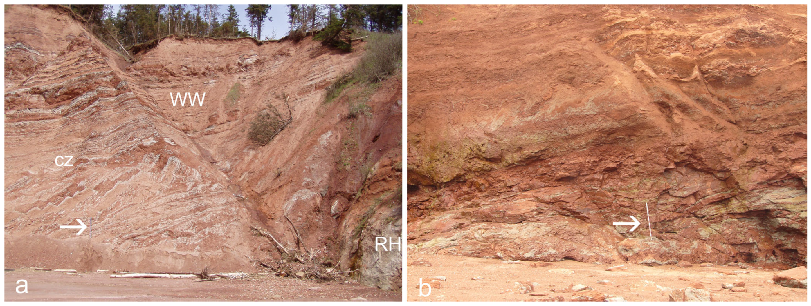
The Blomidon Formation contains a prominent zone of synsedimentary deformation near the base of the White Water Member that is correlatable basin-wide (Figure 2a,b). At Red Head, on the north shore of the Minas Basin (Figure 1), the deformation zone is approximately 10 m thick and is overlain by undisturbed strata (Figure 2a). The stratigraphic height of the zone above the formation base is difficult to measure here due to post-depositional faulting, but on the Blomidon Peninsula, the base of the deformation zone (Figure 2b) is ca. 15 m above the contact with the underlying Wolfville Formation. At Red Head, the zone displays en echelon listric normal faults, downthrown to the east, that cut multiple sandstone–mudstone cycles and appear to sole out at a common horizon. The throw on the faults decreases with sections from about 2 m near the base of the zone to 0.2 m at about one meter below the top of the deformation. The uppermost 0.5 m of the zone displays centimeter-scale fragmentation that nearly obliterates the sedimentary bedding. Similar features are exposed in strata near the base of the Blomidon Formation on the east side of the Blomidon Peninsula, approximately 25 km southwest of Red Head, but here the deformation zone has a thickness of 4 m. A mechanism of solution collapse of evaporite-bearing strata for the deformation features was initially proposed [34], and the possibility of a seismic origin for the prominent deformed zone observed lower in the formation was discounted. Notably, evaporate beds or intervals are not present in outcrops, and no evidence exists for the presence of evaporite beds within the Blomidon in either of the two deep petroleum exploration wells drilled on the northwestern margin of the Fundy Basin [31]. The greater severity of deformation at outcrops on the northern (faulted) side of the Minas Basin, close to the MFZ at Red Head, was noted by [29] (Figure 2a). Moreover, the deformed zone there contains features more consistent with intense seismicity than solution collapse [29]. Thus, ref. [29] hypothesized that deformation in the formation resulted from left-lateral movement of the MFZ that was triggered by seismicity from the Manicouagan impact, ca. 750 km in distance. Modeling based on the crater size suggests that the impact was capable of generating a seismic event of magnitude ca. 10 [39], causing ca. 5 m of vertical ground displacement in the vicinity of the Fundy Basin [40]. Consequently, the synsedimentary deformation in the Blomidon Formation is interpreted as the result of reactivation of pre-existing faults by the Manicouagan impact.
The hypothetical connection between the impact and the deformation in the Fundy Basin was tested by examining thin sections and individual grains from sandstones at the top of the lowest and most deformed zone in the Blomidon Formation. Some component quartz appeared to contain a single set of planar deformation features (PDFs). A few grains that appeared to contain multiple sets of PDFs were examined by universal stage petrography, but none were confirmed as consistent with an impact shock origin [41]. However, a single grain of ballen quartz was identified [41]. Several spherical grains were identified that may represent impact spherules (Figure 5b in [29]). The layer at the top of the deformed zone that hosts the putative impact-derived grains was analyzed for geochemical signatures of impact; these attempts included analysis for anomalous concentrations of platinum group elements, fullerene compounds, and wildfire-generated soot, but results of these analyses all proved negative [42].

2.3. Analytical Methods

Subsequent to the initial work [29], the authors of the current study conducted additional field work to collect samples of sandstone and coarse mudstone from above and below the deformed zones on both the north of the Minas Basin at Red Head, and ca. 25 km to the southwest at Dellhaven, on the eastern shore of the Blomidon Peninsula (Figure 1a). From these samples, fifty standard petrographic thin sections were prepared for study. Additionally, about 1 kg of sandstone was disaggregated for the examination of individual grains; the material was generally loosely consolidated and did not require any chemical treatments for grain separation. Individual grains were examined with a binocular dissecting microscope, and approximately 2500 grains were selected for scanning electron microscopy (SEM). Grains were mounted (via carbon tape) on aluminum stubs and etched with HF vapor per established methods [43]. Most grain mounts were coated with gold and examined by SEM (model JEOL JSM-6510LV, manufactured by JEOL USA, Peabody, MA, USA, equipped with energy dispersive X-ray spectrometer or EDS) using the secondary electron detector at high vacuum and an accelerating voltages of 10–20 kV. A small number of samples were left uncoated and examined with the back-scattered electron detector at partial vacuum and an accelerating voltage of 10–15 kV. Grains with questionable mineralogy (quartz vs. feldspar) were spot analyzed by EDS for the presence of Al.

3. Results

3.1. Shocked Grains

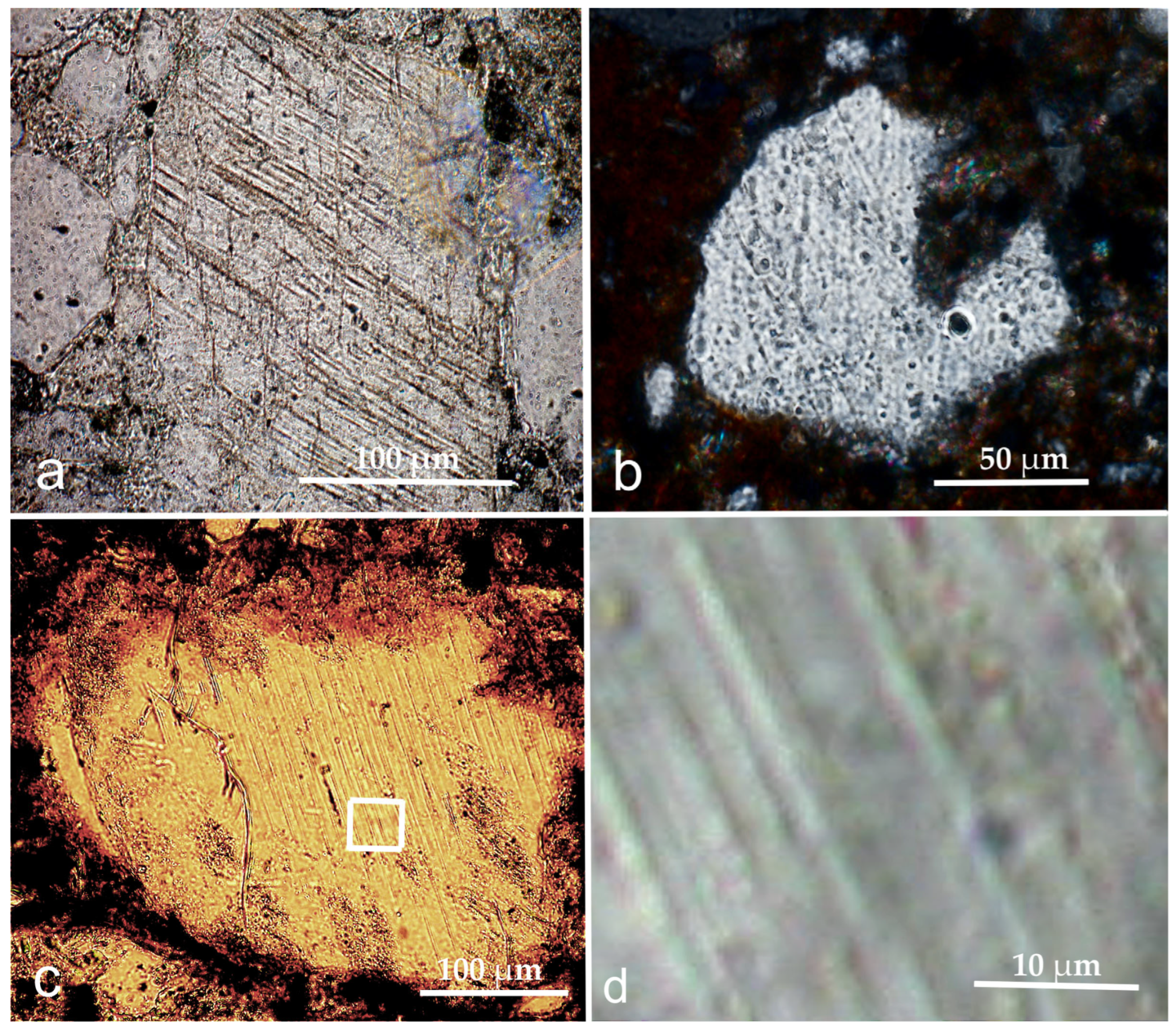
The examination of 50 thin sections and ca. 2500 grains mounted for SEM study yielded 14 individual grains displaying sets of parallel planar features and four spherical grains of interest (in addition to the grains reported previously in [29]). Fractured grains were considered impact-related only where the planar features are closely spaced, parallel and completely straight [44]; i.e., we attempt to identify and exclude features such as Böhm lamellae, which are common in quartz grains in the Blomidon Formation (Figure 3a) [6,45]. Petrographic microscopy revealed multiple quartz grains in which one or more sets of planar features are visible within some portion of the grain. Most commonly, however, the planar sets typically do not extend the entire grain width or are indistinct (Figure 3b). In some of these grains, the apparent planar fractures are highlighted by linear inclusions or “decorations” that may be formed by partial annealing of the fractures [44] (Figure 3b). As these grains were not examined with a universal stage, the origin of the deformation features is considered ambiguous. In this study, only one grain was observed in the thin sections that fully meets the criteria above (Figure 3c,d).
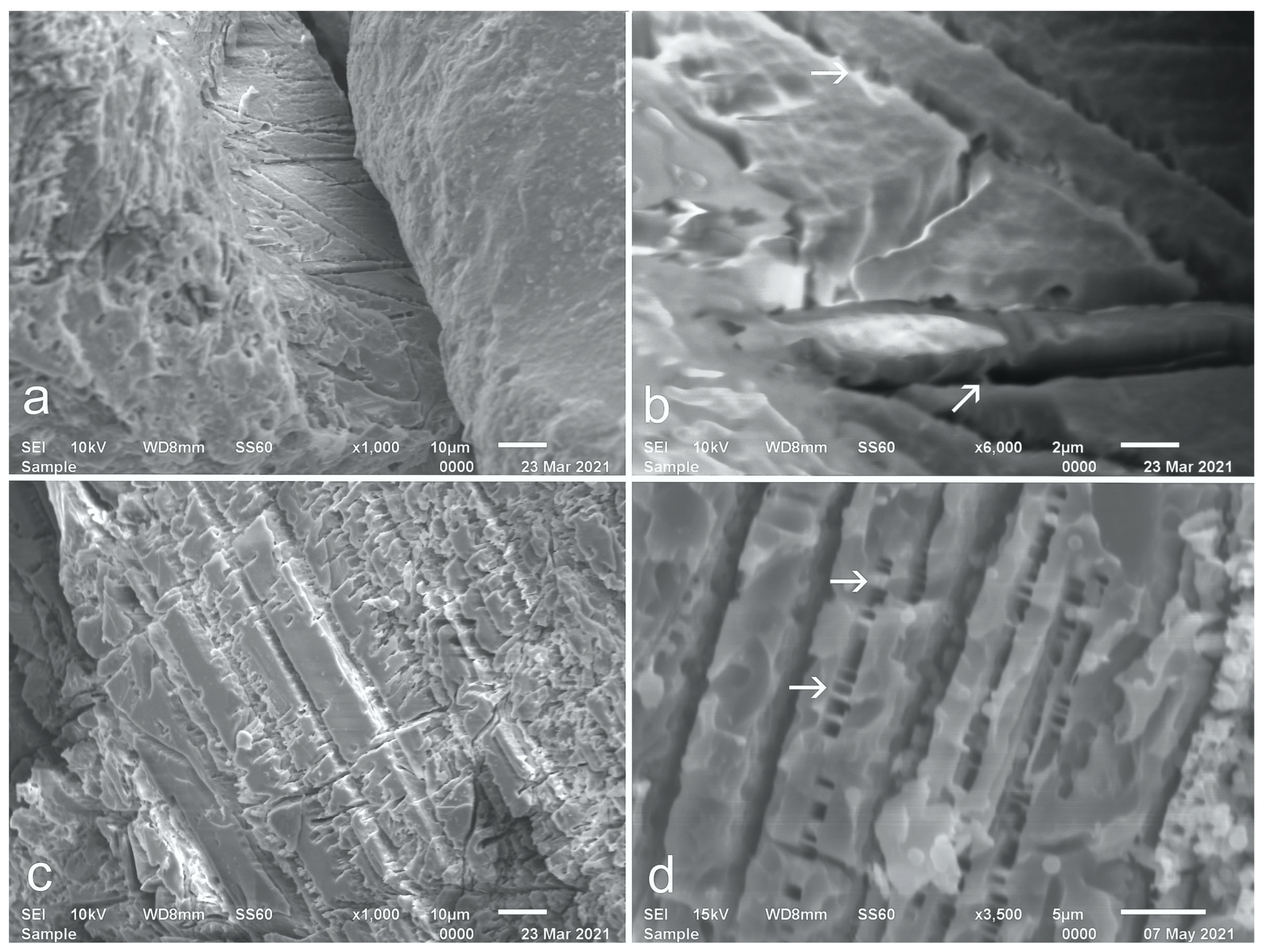
Greater success was obtained from the examination of the HF-etched grains by SEM. Of the 14 grains in which the identification of planar features is confident, 11 are quartz and 3 are feldspar. One quartz grain displayed two intersecting sets of planar lamellae (Figure 4a,b), and the remainder of the grains displayed a single set (Figure 4c,d). The planar lamellae are approximately 1 μm wide and separated by 4 to 5 μm; these features have the dimensions typical of lamellae previously described as produced by shock metamorphism [46]. Additionally, the planar lamellae contain pillar structures (Figure 4b,d), presumably resulting from the removal during chemical etching of glass from partially annealed lamellae [44]. Three grains with lamellae have cleavage angles at 90°, which suggests that they are feldspars, which was confirmed by EDS (Figure 4c). The impact origin of the lamellae in the feldspars, as opposed to potential etching along twin planes, is affirmed by the presence of pillar structures in the etched gaps [47]. These grains originated from samples collected from outcrops at the top of the deformed zone in the lower Blomidon Formation on both the north and south coasts of the Minas Basin at Red Head and Dellhaven, respectively, locations that are separated by ca. 33 km.

3.2. Other Grain Types

Shocked mineral grains are not the only ejecta type associated with impacts. One grain type is ballen quartz, a texture consisting of aggregates of quartz and/or cristobalite formed by impact pressures and temperatures [44,48,49]. One such grain was identified previously from the Blomidon Formation thin sections, as described above [29], but none have since been identified conclusively.
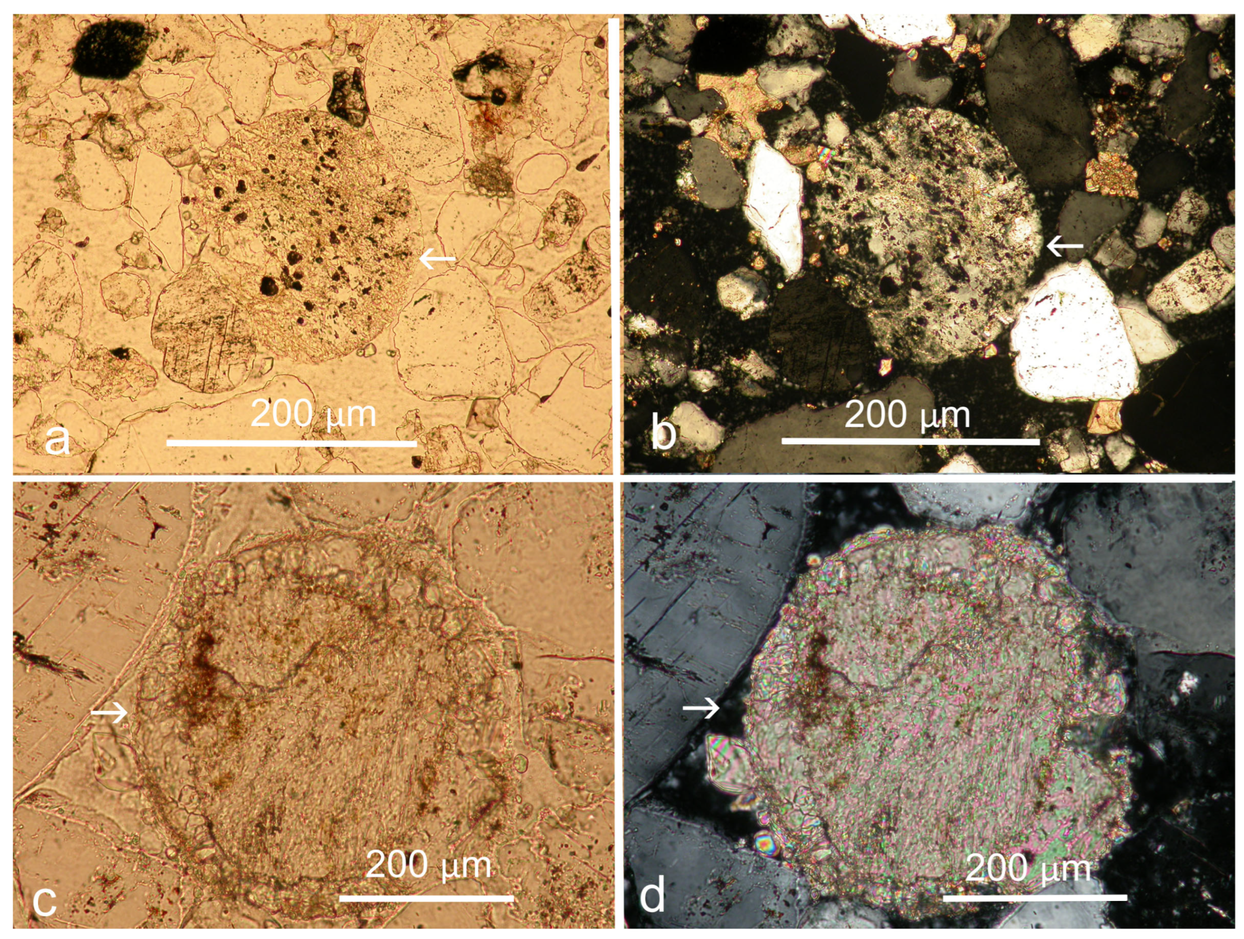
In addition to describing impact-derived spherules, additional types of ejecta grains described in the Wickwar ejecta deposit include the aforementioned accreted grain clusters (AGCs) and clastic-cored spherules (CCS) [28]. The latter texture describes one grain presented previously from the Blomidon Formation (Figure 5b in [29]), consisting of an isotropic rim surrounding a seriticized core. In the study herein, thin-section petrography identifies several additional potential CCSs from the Blomidon Formation, one of which appears partially sericitized (Figure 5a,b).
One grain identified in a thin section may represent an altered spherule of the type that dominates the Wickwar deposit. One thin section from the sandstone layer at the top of the deformed zone contains a subspherical carbonate grain, 400 μm in diameter, displaying the outline of a rim surrounding an inner core (Figure 5c,d). We interpret this grain as representing an initially hollow melt spherule in which both the interior and the rim have been replaced by calcite.

4. Discussion

4.1. Scarcity of PDFs

Among the diagnostic criteria for an impact origin for detrital grains, perhaps the most recognizable and commonly cited is the impact-shock fracturing of quartz grains that produces (commonly) multiple planar sets of fine fracture lamellae [44,50]. Notably, there is great variability in the relative proportions of shocked quartz and spherules in the Wickwar deposit [24]. Petrographic analysis in a later study [27] on material from the same deposit examined earlier [24] identified quartz grains with PDFs on only 23 of the 1260 grains they examined. Significantly, both studies [24,27] noted that most shocked quartz displayed only a single set of PDFs. Specifically, the latter study [27] identified only one quartz grain with multiple PDFs in the 1260 grains examined in their study. Therefore, the low ratio of grains with multiple sets of PDFs compared to grains with single sets of PDFs, as seen in the Blomidon Formation, is consistent with the findings of these earlier studies of the Manicouagan-derived ejecta at Wickwar. As PDFs in quartz are presumed to form parallel to major crystallographic axes [44], single sets of PDFs have been proposed as forming parallel to the basal axis (0001) due to shock impact, albeit at lower pressures than for multiple sets of PDFs (reviewed in [44]). We argue here that grains displaying single PDF sets in the Blomidon Formation and at Wickwar have an impact-shock origin, an interpretation supported by their association with other ejecta grains.

4.2. Ejecta Reworking

The ejecta, if the grains presented in evidence thereof are accepted as such, are sparse within the beds examined at and immediately above the deformed zone, but notably, they are absent elsewhere in the Blomidon Formation. For example, thin sections of the Partridge Island Member of the Blomidon Formation, where elevated levels of PGEs occur, contain no evidence of ejecta [51,52], nor are there any observations of ejecta in the underlying Wolfville Formation [6]. Interestingly, the Earth Impact Effects Program [53] provides an estimation of the thickness of ejecta at a distance from an impact site if various parameters of the impactor can be approximated. Using this program and assuming a bolide of 8 km diameter (a conservative estimate based on the 85 km to 100 km pre-erosional crater diameter), with a density of 3000 kg/m3 (assuming the minimum density for a chondritic body) impacting crystalline bedrock at a velocity of 17 km/s (a typical value for asteroid impact [53]) and at an angle of 45° (considered the most probable angle [53]) is capable of producing an ejecta layer with a mean thickness of 15.6 cm at a distance of 750 km. Clearly, no such ejecta layer has been found at any level in the Blomidon Formation or any other formation in the Fundy Basin. However, as noted previously [29], the environment of deposition during sedimentation of the White Water Member of the Blomidon Formation was one of low accumulation rate, potentially as low as 0.02 mm/a [36]. Deposition in this environment was dominated by sheetwash and eolian processes [54], as evidenced by an abundance of detrital grains displaying eolian rounding. Thus, ejecta from the Manicouagan impact, particularly the clay-sized material that comprises the major portion of many ejecta layers preserved in deep-marine settings, would have been subjected to substantial reworking and eolian deflation in this setting. This contrasts with the depositional setting for the Wickwar deposits, where the local hydrodynamics of the fluvial environment acted to concentrate the spherules.

4.3. Trigger of Seismicity

Despite the absence of a distinct ejecta layer in the Blomidon Formation, we find the presence of grains with an origin likely related to the Manicouagan impact based on grain morphology, age and proximity. These grains are notable for their distribution, apparently limited to the sedimentary layers at and immediately above the top of the primary seismically deformed zone in the lower Blomidon Formation. This finding supports the initial hypothesis that the seismic deformation, with a proximal cause of movement on the Minas Fault Zone, was triggered indirectly by the Manicouagan impact ca. 215.5 Ma [29]. Estimation of the seismic effects of the impact using the Earth Impact Effects Program with the parameters described above yields a seismic magnitude of 9.6 that would produce shaking of Mercalli Intensity between IV and V [53] at 750 km from the impact site. This level of seismicity by itself would not produce the intense deformation observed in the lower White Water Member of the Blomidon Formation, but hypothetically it could have triggered a substantial shift on the Minas fault zone, the basin-bounding fault.

4.4. Magnetostratigraphic Implications

Additional support would exist for the correlation of Blomidon seismicity to the Manicouagan impact if an accurate temporal correlation of the ejecta-bearing strata could be made to the impact. The magnetostratigraphy of a core that includes the entire thickness of the Blomidon Formation is available for comparison [36]. The GAV-77-3 core, stored at the Nova Scotia Department of Energy and Renewables Drill Core Library in Stellarton, Nova Scotia, was drilled ca. 50 km to the southwest of sample sites on the southern side of the Minas Basin at Dellhaven, and ca. 75 km southwest of the sample site on the northern shore of the Minas Basin at Red Head (Figure 1). Although the Blomidon outcrops cannot be correlated precisely to the GAV-77-3 core due to faulting of the outcrop section, the zone of deformation and the ejecta-bearing beds clearly occur above the eolian and fluvial Red Head Member in the lower portion of the White Water Member. By correlation to the top of the Red Head Member in GAV-77-3 magnetostratigraphy, the ejecta-bearing horizon in outcrop occurs in the Bl-1r chron [36], which the authors correlate to the E15r chron in the Newark Astrochronostratigraphic Polarity Time Scale (APTS) (see Figure 4 in [36]). The E15r chron has an age of 212 Ma to 212.5 Ma in the APTS [15]. If this correlation is correct, it would contradict the placement of the Manicouagan impact age (215.5 Ma) in the Newark–Hartford astrochronology in the E14n chron [15]. Importantly, an abbreviated magnetostratigraphic section from the Mino terrane containing the ejecta layer was presented by [20], in which the authors also correlated the zone containing the ejecta layer to the Newark E15r chron.
Notably, the entire Upper Triassic sedimentary sequence of the Newark Basin has been cored; the Newark Basin Coring Project yielded nine kilometers of overlapping cores. Identification of an ejecta layer in the cores from the Newark Basin for impact ejecta would conclusively determine the magnetochron during which the Manicouagan impact occurred. The E15r interval in the Newark Basin cores comprises ca. 100 m of mostly red alluvial and lacustrine mudstones of the lower Passaic Formation [15]. Examination of thin sections cut from thin sandy layers within this interval failed to identify any potential ejecta materials [55], calling into question the correlations of both the Blomidon and Mino terrane magnetostratigraphy to the Newark APTS.
An alternative hypothesis is that both the correlation of the Mino terrane ejecta layer [20] and the basal White Water Member of the Blomidon Formation to the E15r chron in the Newark Basin cores are in error. The correlation of the ejecta layer in the Mino terrane (Japan) to the Newark E15r chron was based in part on the location of the ejecta at or near the base of the E. bidentata conodont zone in a short interval (a subchron) of normal polarity within a longer reversed interval, which also characterizes the PM 10r interval at Pizzo Mondello (see Figure 6 in [20]). However, other paleomagnetic correlations suggest that this correlation may be inaccurate. The Alaunian/Sevatian boundary (as defined by the base of the E. bidentata zone) has long been considered somewhat imprecise and possibly diachronous [56,57], spanning the UT20r/UT21n magnetochrons in the most recent iterations of the Global Paleomagnetic Time Scale, GPTS-B [58,59]. This zone is, in turn. correlated to the uppermost E14r to lowermost E15n chrons in the Newark Basin (see Figure 9 in [59]). In the current version of the Newark APTS [15], this interval spans ca. 214 Ma to ca. 213 Ma. Therefore, if the Manicouagan impact ejecta layer in Japan occurs at or very near the base of the E. bidentata conodont zone, as presently accepted, and if the age of the Manicouagan impact is accurately dated at or near 215.5 Ma, the Newark time scale is inaccurate by 1.5 Ma to 2.5 Ma years.
Unfortunately, the Newark basin cores lack materials that can provide radioisotopic dates. Rather, the APTS relies largely on the chronology provided by orbital (Milankovitch) cycles inferred from the changing alluvial and lacustrine lithologies. Previous workers have suggested that the stratigraphic record of the Upper Triassic in the Newark Basin is incomplete. For example, a study of regional conchostracan biostratigraphy [60] claimed that the Rhaetian stage is mostly to completely missing here. More recent magnetostratigraphic correlations have interpreted an unconformity in the Newark Basin between the E14n and E14r chrons [58], or higher in the section [59].
Some clarification for the stratigraphic position of the Manicouagan impact may be provided by the magnetostratigraphy of the Upper Triassic Chinle Formation of the southwestern United States, in which radioisotopic dates have been obtained from detrital zircons [59]. Chron CC5r from the Chinle Formation, which is correlated to the Newark APTS chron E14r (Figure 9 in [59]), has yielded dates with a range of ca. 216 Ma to 211.9 Ma from the Sonsela Member of the Chinle Formation [58,59]. Similarly, a separate Chinle data set [61] correlates chron PF4r to the Newark chron E14r, indicating its equivalence to the CC5r of [59]. These concordant correlations support a stratigraphic position of the Manicouagan impact within an interval of the Sonsela Member equivalent to the middle to upper E14r chron in the Newark Basin, a position that is dated by the Newark APTS as ca. 214 Ma to 213.5 Ma.
The Blomidon Formation lacks the biostratigraphy of the marine sections used to build the GPTS, or the detrital zircons that date the Sonsela Member of the Chinle Formation. Thus, if the ejecta-bearing horizon of the Blomidon Formation occurs within the Bl-1r chron at the base of the White Water member, the Bl-1r chron also correlates to the Newark E14r chron, not the E15r as previously proposed. Clearly, identification of ejecta from the Manicouagan impact in the Newark Basin strata, within the E14r interval or another interval higher or lower in the stratigraphic section, would provide a fixed, absolute age point within the magnetostratigraphic record and clarify these questions about the accuracy of the Newark APTS.

5. Conclusions

Impact ejecta consisting of shocked quartz grains, most of which exhibit a single set of PDFs, occur in small quantities within sandstone beds at and immediately above a prominent deformed zone in the lower Blomidon Formation, Fundy Basin, Nova Scotia. Also found in these beds are scarce carbonate-replaced spherules and clastic-cored spherules. The scarcity of the ejecta is explained by intense sedimentary reworking and potential eolian deflation at the margin of an arid basin with a very low accommodation rate. The deformed zone overlain by the ejecta-bearing strata is interpreted as a seismite produced by intense movement on the nearby Minas Fault Zone, but the movement of this fault is hypothesized to have been triggered by the seismic shock produced by the Manicouagan impact event, ca. 750 km distant. Correlation of the deformed zone from outcrops to the magnetostratigraphic record of a drill core of the Blomidon Formation from the Fundy Basin suggests a discrepancy in the correlation to the Newark APTS. Correlation of the GPTS-B stratigraphy, which is based on both biostratigraphic controls and magnetostratigraphy, to the Chinle Formation of the southwestern United States and to the Newark APTS also suggests a temporal discrepancy of 1.5 Ma to 2 Ma in the latter. Continued investigation of outcrops and cores from the Newark Basin is required to resolve this discrepancy.

Author Contributions

Project conceptualization by L.H.T., M.J.C. and D.E.B.; Sample collection by L.H.T., M.J.C. and D.E.B.; Petrographic analysis by L.H.T. and M.J.C.; SEM analysis by L.H.T.; Manuscript initial draft by L.H.T.; Editing and revisions by M.J.C. and D.E.B. All authors have read and agreed to the published version of the manuscript.

Funding

This research received no external funding.

Data Availability Statement

Samples analyzed, including thin sections for this study, are archived at the Department of Biological and Environmental Sciences at Le Moyne College and can be made available on request.

Acknowledgments

Joshua Bonila, an undergraduate student at Le Moyne College, assisted in the collection of SEM images.

Conflicts of Interest

The authors declare no conflicts of interest.

Abbreviations

The following abbreviations are used in this manuscript:
ID-TIMSisotope dilution thermal ionization mass spectrometry
CA-ID-TIMSchemical abrasion isotope dilution thermal ionization mass spectrometry
K-PgCretaceous-Paleogene boundary
PGEPlatinum group elements
PDFsPlanar deformation features
AGCAccreted grain clusters
MFZMinas Fault Zone
CCSClastic cored spherules
SEMScanning electron microscopy
APTSAstrochronostratigraphic Polarity Time Scale
GPTSGlobal Paleomagnetic Time Scale

References

  1. O’Connell-Cooper, C.D.; Spray, J.G. Geochemistry of the Manicouagan Impact melt sheet. In Proceedings of the 41st Lunar and Planetary Science Conference, The Woodlands, TX, USA, 1–5 March 2010. [Google Scholar]
  2. Grieve, R.A.; Head, J. W, III. The Manicouagan impact structure: An analysis of its original dimensions and form. J. Geophys. Res. Solid Earth 1983, 88, A807–A818. [Google Scholar] [CrossRef]
  3. Spray, J.G.; Thompson, L.M.; Biren, M.B.; O’Connell-Cooper, C.D. The Manicouagan impact structure as a terrestrial ana-logue site for lunar and Martian planetary science. Planet. Space Sci. 2010, 58, 538–551. [Google Scholar] [CrossRef]
  4. Thompson, L.M.; Spray, J.G. The Manicouagan impact research program, and other Canadian impact crater studies. In Proceedings of the 76th Annual Meeting of the Meteoritical Society, Edmonton, AB, Canada, 29 July–2 August 2013. [Google Scholar]
  5. Brown, J.J.; Spray, J.G.; Thompson, L.M. Shock Attenuation within the Manicouagan Impact Structure. In Proceedings of the 47th Lunar and Plan-Etary Science Conference, The Woodlands, TX, USA, 21–25 March 2016. [Google Scholar]
  6. Clutson, M.J.; Brown, D.E.; Tanner, L.H. Distal processes and effects of multiple Late Triassic terrestrial bolide impacts: Insights from the Norian Manicouagan event, northeastern Quebec, Canada. In The Late Triassic World; Tanner, L.H., Ed.; Springer: Cham, Switzerland, 2018; pp. 127–187. [Google Scholar]
  7. Olsen, P.E.; Shubin, N.H.; Anders, M.H. New Early Jurassic tetrapod assemblages constrain Triassic-Jurassic tetrapod extinction event. Science 1987, 237, 1025–1029. [Google Scholar] [CrossRef] [PubMed]
  8. Olsen, P.E.; Kent, D.V.; Sues, H.D.; Koeberl, C.; Huber, H.; Montanari, A.; Rainforth, E.C.; Fowell, S.J.; Szajna, M.J.; Hartline, B.W. Ascent of dinosaurs linked to an iridium anomaly at the Triassic-Jurassic boundary. Science 2002, 296, 1305–1307. [Google Scholar] [CrossRef] [PubMed]
  9. Olsen, P.E.; Koeberl, C.; Huber, H.; Montanari, A.; Fowell, S.; Et-Touhami, M.; Kent, D.V. The continental Triassic–Jurassic boundary in central Pangea: Recent progress and preliminary report of an Ir anomaly. In Catastrophic Events and Mass Extinctions: Impacts and Beyond; Koeberl, C., MacLeod, K.G., Eds.; Geological Society of America Special Paper 356; Geological Society of America: Boulder, CO, USA, 2002; pp. 505–522. [Google Scholar]
  10. Hodych, J.P.; Dunning, G.R. Did the Manicouagan impact trigger end-of-Triassic mass extinctions? Geology 1992, 20, 51–54. [Google Scholar] [CrossRef]
  11. Ramezani, J.; Bowring, S.A.; Pringle, M.S.; Winslow, F.D., III; Rasbury, E.T. The Manicouagan impact melt rock: A proposed standard for the intercalibration of U-Pb and 40Ar/39Ar isotopic systems. Geochim. Cosmochim. Acta 2005, 69, 321. [Google Scholar]
  12. van Soest, M.C.; Hodges, K.V.; Wartho, J.A.; Biren, M.B.; Monteleone, B.D.; Ramezani, J.; Spray, J.G.; Thompson, L.M. (U–Th)/He dating of terrestrial impact structures: The Manicouagan example. Geochem. Geophys. Geosyst. 2011, 12, 1–8. [Google Scholar] [CrossRef]
  13. Biren, M.B.; van Soest, M.; Wartho, J.-A.; Spray, J.G. Dating the cooling of exhumed central uplifts of impact structures by the (U-Th)/He method: A case study at Manicouagan. Chem. Geol. 2014, 377, 56–71. [Google Scholar] [CrossRef]
  14. Jaret, S.J.; Hemming, S.R.; Rasbury, E.T.; Thompson, L.M.; Glotch, T.D.; Ramezani, J.; Spray, J.G. Context Matters—Ar-Ar Results from in and around the Manicouagan Impact Structure: Implications for Martian Meteorite Chronology. Earth Planet. Sci. Lett. 2018, 501, 78–89. [Google Scholar] [CrossRef]
  15. Kent, D.V.; Olsen, P.E.; Muttoni, G. Astrochronostratigraphy polarity time scale (APTS) for the Late Triassic and Early Jurassic from continental sediments and correlation with standard marine stages. Earth Sci. Rev. 2017, 166, 153–180. [Google Scholar] [CrossRef]
  16. Onoue, T.; Sato, H.; Nakamura, T.; Noguchi, T.; Hidaka, Y.; Shiraid, N.; Ebihara, M.; Osawa, T.; Hatsukawa, Y.; Toh, Y.; et al. Deepsea record of impact apparently unrelated to mass extinction in the Late Triassic. Proc. Natl. Acad. Sci. USA 2012, 109, 19134–19139. [Google Scholar] [CrossRef]
  17. Parker, W.J.; Martz, J.W. The Late Triassic (Norian) Adamanian–Revueltian tetrapod faunal transition in the Chinle Formation of Petrified Forest National Park, Arizona. Earth Environ. Sci. Trans. R. Soc. Edinb. 2011, 101, 231–260. [Google Scholar] [CrossRef]
  18. Sato, H.; Onoue, T.; Nozaki, T.; Suzuki, K. Osmium isotope evidence for a large Late Triassic impact event. Nat. Commun. 2013, 4, 2455. [Google Scholar] [CrossRef]
  19. Sato, H.; Shirai, N.; Ebihara, M.; Onoue, T.; Kiyokawa, S. Sedimentary PGE signatures in the Late Triassic ejecta deposits from Japan: Implications for the identification of impactor. Paleogeogr. Palaeoclim. Palaeoecol. 2016, 442, 36–47. [Google Scholar] [CrossRef]
  20. Uno, K.; Yamashita, D.; Onoue, T.; Uehara, D. Paleomagnetism of Triassic bedded chert from Japan for determining the age of an impact ejecta layer deposited on peri-equatorial latitudes of the paleo-Pacific Ocean: A preliminary analysis. Phys. Earth Planet. Inter. 2015, 249, 59–67. [Google Scholar] [CrossRef]
  21. Kirkham, A. Triassic microtektite pseudomorphs of the Bristol area. Geoscient 2002, 12, 17–18. [Google Scholar]
  22. Kirkham, A. Glauconitic spherules from the Triassic of the Bristol area, S.W. England: Probable microtektite pseudomorphs. Proc. Geol. Assoc. 2003, 114, 11–21. [Google Scholar] [CrossRef]
  23. Kirkham, A. Triassic Meteorite Impact? Mag. Geol. Assoc. 2006, 5, 21. [Google Scholar]
  24. Walkden, G.; Parker, J.; Kelley, S. A Late Triassic impact ejecta layer in southwestern Britain. Science 2002, 298, 2185–2188. [Google Scholar] [CrossRef] [PubMed]
  25. Thackrey, S.; Walkden, G.; Kelley, S.; Parrish, R.; Horstwood, M.; Indares, A.; Stills, J.; Spray, J. Determining source of ejecta using heavy mineral provenance techniques; A Manicouagan distal ejecta case study. In Proceedings of the 39th Lunar and Planetary Science Conference, League City, TX, USA, 10–14 March 2008. Abst.1254. [Google Scholar]
  26. Thackrey, S.; Walkden, G.; Indares, A.; Horstwood, A.; Kelley, S.; Parrish, R. The use of heavy mineral correlation for deter-mining the source of impact ejecta: A Manicouagan distal ejecta case study. Earth Planet. Sci. Lett. 2009, 285, 163–172. [Google Scholar] [CrossRef]
  27. Jaret, S.J.; Hesselbo, S.P.; Rasbury, E.T.; Ebel, D.S. Petrography and Provenance of Triassic Impact Ejecta from SW England, United Kingdom. In Proceedings of the 51st Lunar and Planetary Science Conference, The Woodlands, TX, USA, 16–20 March 2020. Abstr. 2389. [Google Scholar]
  28. McGregor, M.; Spray, J.G.; McFarlane, C.R. Provenance constraints on the Late Triassic ejecta layer from Churchwood Quar-ry, SW England: An impactite suite from Manicouagan. Meteorit. Planet. Sci. 2024, 59, 1632–1657. [Google Scholar] [CrossRef]
  29. Tanner, L.H. Synsedimentary seismic deformation in the Blomidon Formation (Norian-Hettangian), Fundy basin, Canada. New Mex. Mus. Nat. Hist. Sci. Bull. 2006, 37, 35–42. [Google Scholar]
  30. Olsen, P.E.; Schlische, R.W. Transtensional arm of the early Mesozoic Fundy rift basin: Penecontemporaneous faulting and sedimentation. Geology 1990, 18, 695–698. [Google Scholar] [CrossRef]
  31. Wade, J.A.; Brown, D.E.; Fensome, R.A.; Traverse, A. The Triassic-Jurassic Fundy Basin, Eastern Canada: Regional setting, stratigraphy and hydrocarbon potential. Atl. Geol. 1996, 32, 189–231. [Google Scholar] [CrossRef]
  32. Sues, H.D.; Olsen, P.E. Stratigraphic and temporal context and faunal diversity of Permian-Jurassic continental tetrapod as-semblages from the Fundy rift basin, eastern Canada. Atl. Geol. 2015, 51, 139–205. [Google Scholar] [CrossRef]
  33. Tanner, L.H. Triassic-Jurassic lacustrine deposition in the Fundy rift basin, eastern Canada. In Lake Basins Through Space and Time; Gierlowski-Kordesch, E.H., Kelts, K.R., Eds.; American Association of Petroleum Geologists Studies in Geology; American Association of Petroleum Geologists (AAPG): Tulsa, OK, USA, 2000; Volume 46, pp. 159–166. [Google Scholar]
  34. Ackermann, R.V.; Schlische, R.W.; Olsen, P.E. Synsedimentary collapse of portions of the lower Blomidon Formation (Late Triassic), Fundy rift basin, Nova Scotia. Can. J. Earth Sci. 1995, 32, 1965–1976. [Google Scholar] [CrossRef]
  35. Tanner, L.H. Pedogenic record of paleoclimate and basin evolution in the Triassic-Jurassic Fundy rift basin, eastern Canada. In Aspects of Triassic-Jurassic Rift Basin Geoscience; LeTourneau, P., Olsen, P.E., Eds.; Columbia University Press: New York, NY, USA, 2003; pp. 108–122. [Google Scholar]
  36. Kent, D.V.; Olsen, P.E. Magnetic polarity stratigraphy and paleolatitude of the Triassic-Jurassic Blomidon Formation in the Fundy basin (Canada): Implications for early Mesozoic tropical climate gradients. Earth Planet. Sci. Lett. 2000, 179, 311–324. [Google Scholar] [CrossRef]
  37. Fowell, S.J.; Traverse, A. Palynology and age of the upper Blomidon Formation, Fundy basin, Nova Scotia. Rev. Palaeobot. Pal-Ynol 1995, 86, 211–233. [Google Scholar] [CrossRef]
  38. Cirilli, S.; Marzoli, A.; Tanner, L.H.; Bertrand, H.; Buratti, N.; Jourdan, F.; Bellieni, G.; Kontak, D.; Renne, R.P. The onset of CAMP eruptive activity and the Tr-J boundary: Stratigraphic constraints from the Fundy Basin, Nova Scotia. Earth Planet. Sci. Lett. 2009, 286, 514–525. [Google Scholar] [CrossRef]
  39. Toon, O.B.; Sahnle, K.; Morrizon, D.; Turco, R.P.; Covey, C. Environmental perturbations caused by the impacts of asteroids and comets. Rev. Geophys. 1997, 35, 41–78. [Google Scholar] [CrossRef]
  40. Boslough, M.E.; Chael, E.P.; Trucano, T.G.; Crawford, D.A.; Campbell, D.L. Axial focusing of impact energy in the Earth’s interior: A possible link to flood basalts and hotspots. In The Cretaceous-Tertiary Event and Other Catastrophes in Earth History; Geological Society of America Special Paper 307; Geological Society of America: Boulder, CO, USA, 1996; pp. 541–550. [Google Scholar]
  41. Therriault, A.M. (Earth Sciences Sector, Natural Resources Canada, Ottawa, ON, Canada). Personal communication, 2003.
  42. Kyte, F.T. (Center for Astrobiology, Institute of Geophysics and Planetary Physics, University of California, Los Angeles, CA, USA); Becker, L. (Department of Earth and Space Sciences, University of Washington, Seattle, WA, USA); Wohlbach, W. (Department of Chemistry, DePaul University, Chicago, IL, USA). Personal communication, 2003.
  43. Gratz, A.J.; Fisler, D.K.; Bohor, B.F. Distinguishing shocked from tectonically deformed quartz by the use of SEM and chem-ical etching. Earth Planet. Sci. Lett. 1996, 142, 513–521. [Google Scholar] [CrossRef]
  44. French, B.M.; Koeberl, C. The convincing identification of terrestrial meteorite impact structures: What works, what doesn’t, and why. Earth-Sci. Rev. 2010, 98, 123–170. [Google Scholar] [CrossRef]
  45. Mossman, D.J.; Grantham, R.G.; Langenhorst, F. A search for shocked quartz at the Triassic-Jurassic boundary in the Newark basins of the Newark Supergroup. Can. J. Earth Sci. 1998, 35, 101–109. [Google Scholar] [CrossRef]
  46. Grieve, R.A.F. Extraterrestrial impacts on earth: The evidence and the Consequences. In Meteorites: Flux with Time and Impact Effects; Grady, M.M., Hutchison, R., McCall, G.J.H., Rothery, D.A., Eds.; Geological Society, London, Special Publications 140; Geological Society: London, UK, 1998; pp. 105–131. [Google Scholar]
  47. Pickersgill, A.E.; Osinski, G.R.; Flemming, R.L. Shock effects in plagioclase feldspar from the Mistastin Lake impact structure, Canada. Meteor. Planet. Sci. 2015, 50, 1546–1561. [Google Scholar] [CrossRef]
  48. Trepmann, C.A.; Dellefant, F.; Kaliwoda, M.; Hess, K.U.; Schmahl, W.W.; Hölzl, S. Quartz and cristobalite ballen in impact melt rocks from the Ries impact structure, Germany, formed by dehydration of shock-generated amorphous phases. Meteorit. Planet. Sci. 2020, 55, 2360–2374. [Google Scholar] [CrossRef]
  49. Zamiatina, D.A.; Zamyatin, D.A.; Mikhalevskii, G.B. Ballen quartz in Jänisjärvi impact melt rock with high concentrations of Fe, Mg, and Al: EPMA, EDS, EBSD, CL, and Raman Spectroscopy. Minerals 2022, 12, 886. [Google Scholar] [CrossRef]
  50. Osinski, G.R.; Pierazzo, E. Impact cratering: Processes and products. In Impact Cratering:Processes and Products; Osinski, G.R., Pierazzo, E., Eds.; Wiley-Blackwell: Chichester, UK, 2012; pp. 125–145. [Google Scholar]
  51. Tanner, L.H.; Kyte, F.T.; Walker, A.E. Multiple Ir anomalies in uppermost Triassic to Jurassic-age strata of the Blomidon Formation, Fundy basin, eastern Canada. Earth Planet. Sci. Lett. 2008, 274, 103–111. [Google Scholar] [CrossRef]
  52. Tanner, L.H.; Kyte, F.T. Anomalous iridium enrichment in sediments at theTriassic-Jurassic boundary, Blomidon Formation, Fundy basin, Canada. Earth Planet. Sci. Lett. 2005, 240, 634–641. [Google Scholar] [CrossRef]
  53. Marcus, R.; Melosh, H.J.; Collins, G. Earth Impact Effects Program. 2004. Available online: https://impact.ese.ic.ac.uk/ImpactEarth/ImpactEffects/ (accessed on 20 September 2025).
  54. Mertz, K.A.; Hubert, J.F. Cycles of sandflat sandstone and playa-lacustrine mudstone in the Triassic-Jurassic Blomidon redbeds, Fundy rift basin, Nova Scotia: Implications for tectonic and climatic controls. Can. J. Earth Sci. 1990, 27, 442–451. [Google Scholar]
  55. Tanner, L.H.; Lucas, S.G.; Brown, D.E.; Clutson, M.J. Paleomagnetic and biostratigraphic cprrelation of the Manicouagan impact: Implications for the Late Triassic time scale. Geol. Soc. Am. Annu. Meet. Abst. Progr. 2025, 55, 389693. [Google Scholar]
  56. Hounslow, M.W.; Muttoni, G. The geomagnetic polarity timescale for the Triassic: Linkage to stage boundary definitions. In The Triassic Timescale; Geological Society, London, Special Publications: London, UK, 2010; Volume 334, pp. 61–102. [Google Scholar]
  57. Wu, Q. An integrated study of Upper Triassic Conodont and Radiolarian Biostratigraphy in the Tethyan Realm. Ph.D. Dissertation, Università degli Studi da Padova, Padova, Italy, 2025. [Google Scholar]
  58. Hounslow, M.W.; Gallois, R. Magnetostratigraphy of the Mercia Mudstone Group (Devon, UK): Implications for regional relationships and chronostratigraphy in the Middle to Late Triassic of Western Europe. J. Geol. Soc. 2023, 180, 4. [Google Scholar] [CrossRef]
  59. Hounslow, M.W.; Andrews, J.E. Improved chronostratigraphy and fine-tuned timing for Late Triassic palaeoenvironmental changes in SW Britain using coupled magnetic polarity and carbon isotope stratigraphy. Palaeogeogr. Palaeoclimatol. Palaeoecol. 2024, 656, 112579. [Google Scholar] [CrossRef]
  60. Kozur, H.W.; Weems, R.E. The biostratigraphic importance of conchostracans in the continental Triassic of the northern hemisphere. In The Triassic Timescale; Geological Society, London, Special Publications: London, UK, 2010; pp. 315–417. [Google Scholar]
  61. Kent, D.V.; Olsen, P.E.; Rasmussen, C.; Lepre, C.; Mundil, R.; Irmis, R.B.; Gehrels, G.E.; Giesler, D.; Geissman, J.W.; Parker, W.G. Empirical evidence for stability of the 405-kiloyear Jupiter–Venus eccentricity cycle over hundreds of millions of years. Proc. Natl. Acad. Sci. USA 2018, 115, 6153–6158. [Google Scholar] [CrossRef] [PubMed]
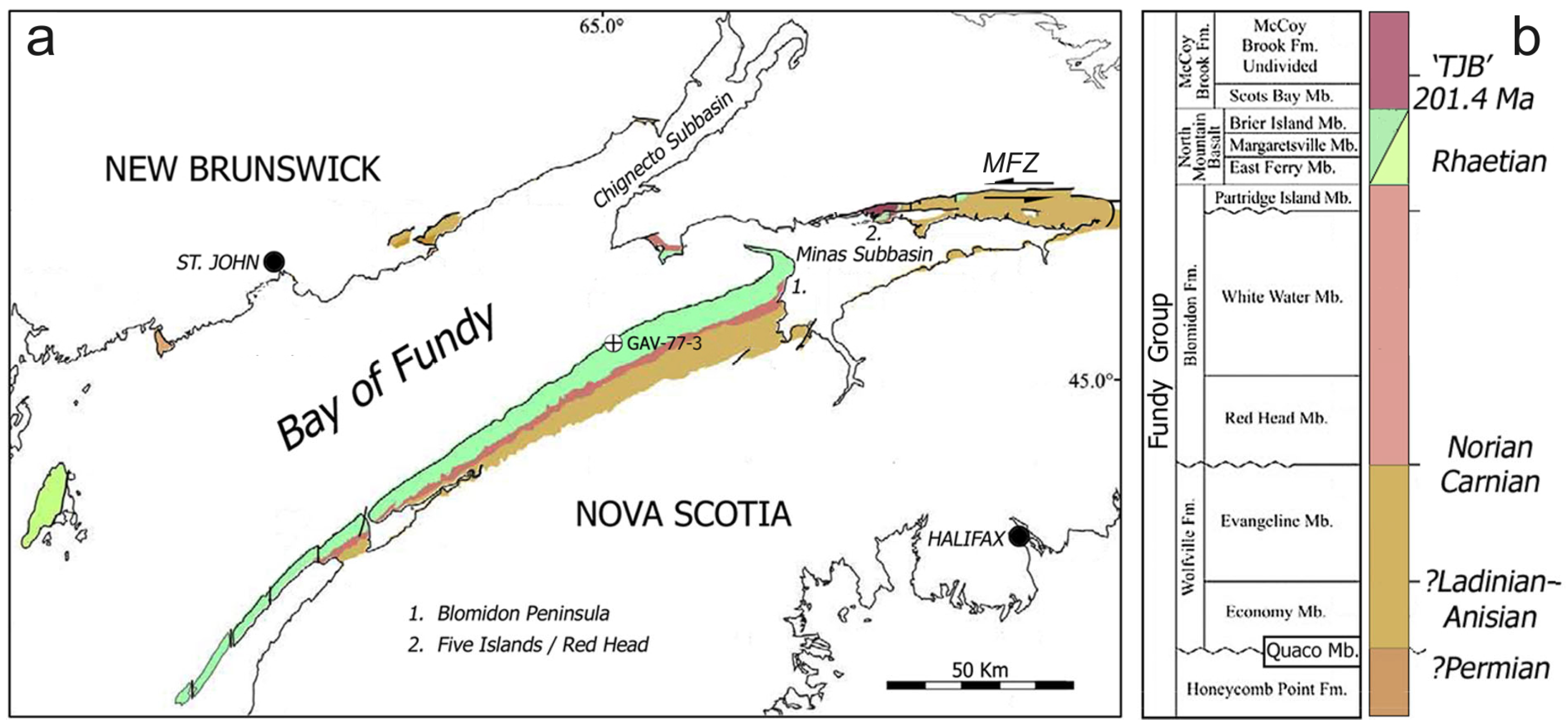
Figure 1. Location map: (a) Regional geology of the Fundy Basin, highlighting outcrop distribution of Triassic formations. Sampling of the Blomidon Formation was conducted at Dellhaven on the Blomidon Peninsula (1) and at Red Head (2). GAV-77-3 is the drilling location of a core of the Blomidon Formation discussed in the text. Modified from [6]; (b) Stratigraphy of the Fundy Basin, after [32], with formation colors keyed to the map in part (a).
Geosciences 15 00400 g001
Figure 2. Disrupted strata in the lower Whitewater Member of the Blomidon Formation: (a) Outcrop at Red Head. WW = White Water Member, RH = Red head Member, cz = collection zone of samples at top of deformation, arrow indicates 1.5 m staff for scale. The fault that juxtaposes the White Water and Red Head members is obscured by vegetation. (b) Outcrop of the correlative deformed zone at beach level at Dellhaven (see Figure 1). Staff for scale.
Geosciences 15 00400 g002
Figure 3. Photos of lamellar features in thin sections from Red Head: (a) Example of lamellae of probable metamorphic origin that are clearly neither straight nor planar. (b) Grain with potential multiple PDFs highlighted by inclusions suggesting multiple directions of fracture, but insufficiently complete for confirmation; (c,d) Quartz grain with a single set of distinct, continuous PDFs that may be shock related; (c) view with plane-polarized light and (d) magnified view of inset box in (c) with crossed polarizers.
Geosciences 15 00400 g003
Figure 4. SEM photos of etched grains with accelerating voltage, working distance between sample and detector, magnification and scale bar size indicated on each frame: (a) Two planes of fracture are visible in a partial view of a surface on a quartz grain collected at Red Head; (b) detail of (a) with pillar structures visible (arrows); (c) feldspar grain from Dellhaven with PDFs; (d) detail of PDFs on quartz grain from Dellhaven with pillar structures (arrows).
Geosciences 15 00400 g004
Figure 5. Other ejecta grains collected at Red Head: (a,b) CCS (clastic-cored spherule), plane-polarized light (a), crossed polarizer view (b). (c,d) Calcite-replaced spherule exhibiting preserved outline of rim (arrow), plane-polarized light (c), crossed-polarizer view (d).
Geosciences 15 00400 g005
Disclaimer/Publisher’s Note: The statements, opinions and data contained in all publications are solely those of the individual author(s) and contributor(s) and not of MDPI and/or the editor(s). MDPI and/or the editor(s) disclaim responsibility for any injury to people or property resulting from any ideas, methods, instructions or products referred to in the content.