Sediment Transport Modeling in the Pasig River, Philippines Post Taal Volcano Eruption
Abstract
1. Introduction
2. Materials and Methods
2.1. Study Area
2.2. Data Collection and Database Preparation
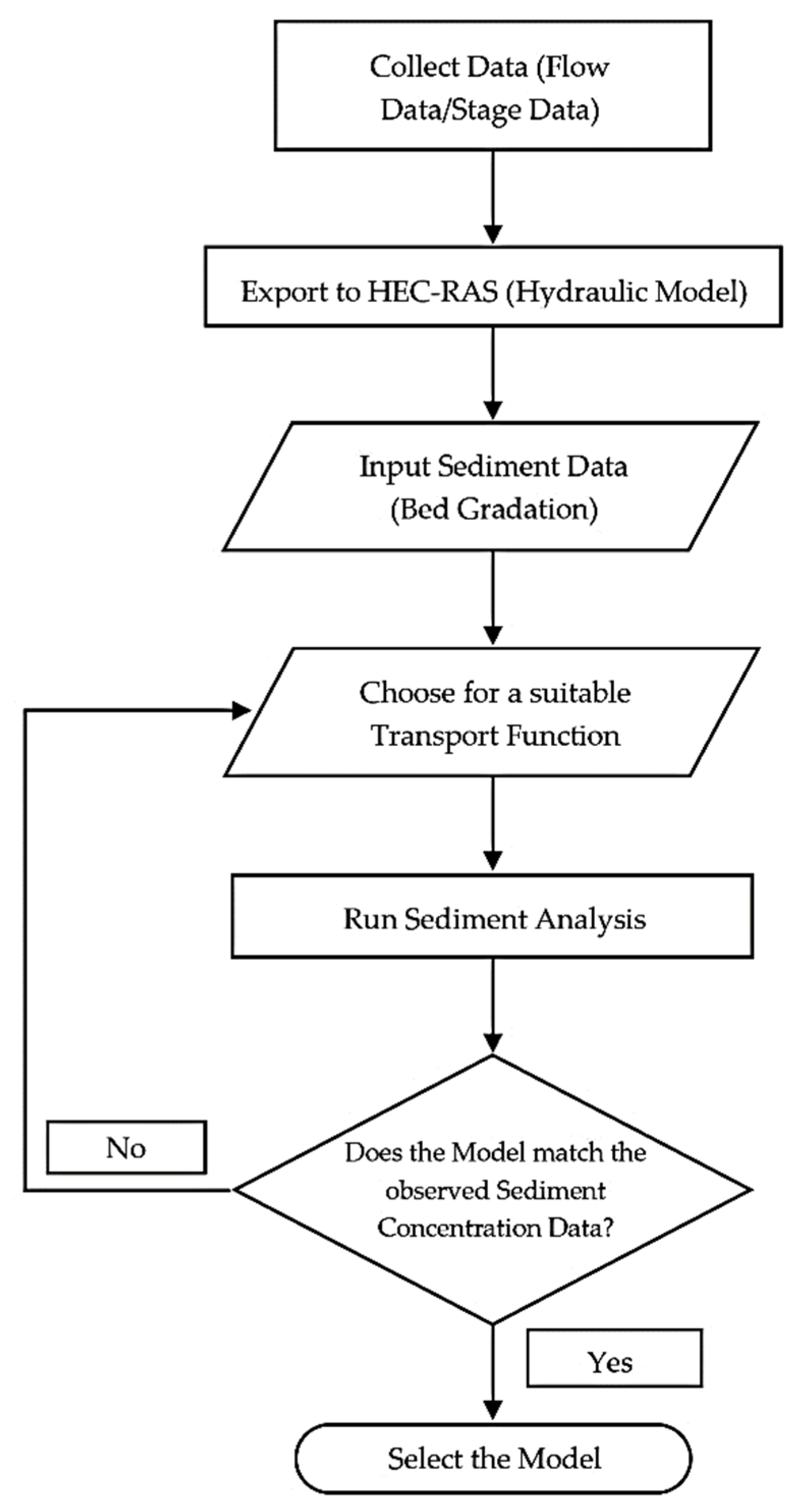
2.3. Modeling Approach
2.3.1. Assumptions
- Channel cross-sections were taken by merging the digital elevation model (DEM) and digital terrain model (DTM) files of the Pasig River that were requested from NAMRIA and IFSAR, respectively. Since the DEM file only measures the surface level of the river, it was merged with the DTM file to assume the shape of the cross-section and the depth of the river more accurately.
- Bed gradation for the upstream part of the river is not readily available from the soil analysis performed using the samples obtained through fieldwork. Results from the investigations of related studies were used as supplementary data for this input parameter. The supplementary data obtained were simplified according to the data on hand.
2.3.2. Geometric Model
2.3.3. Flow Model
2.3.4. Sediment Model
2.4. Model Evaluation
3. Results and Discussion
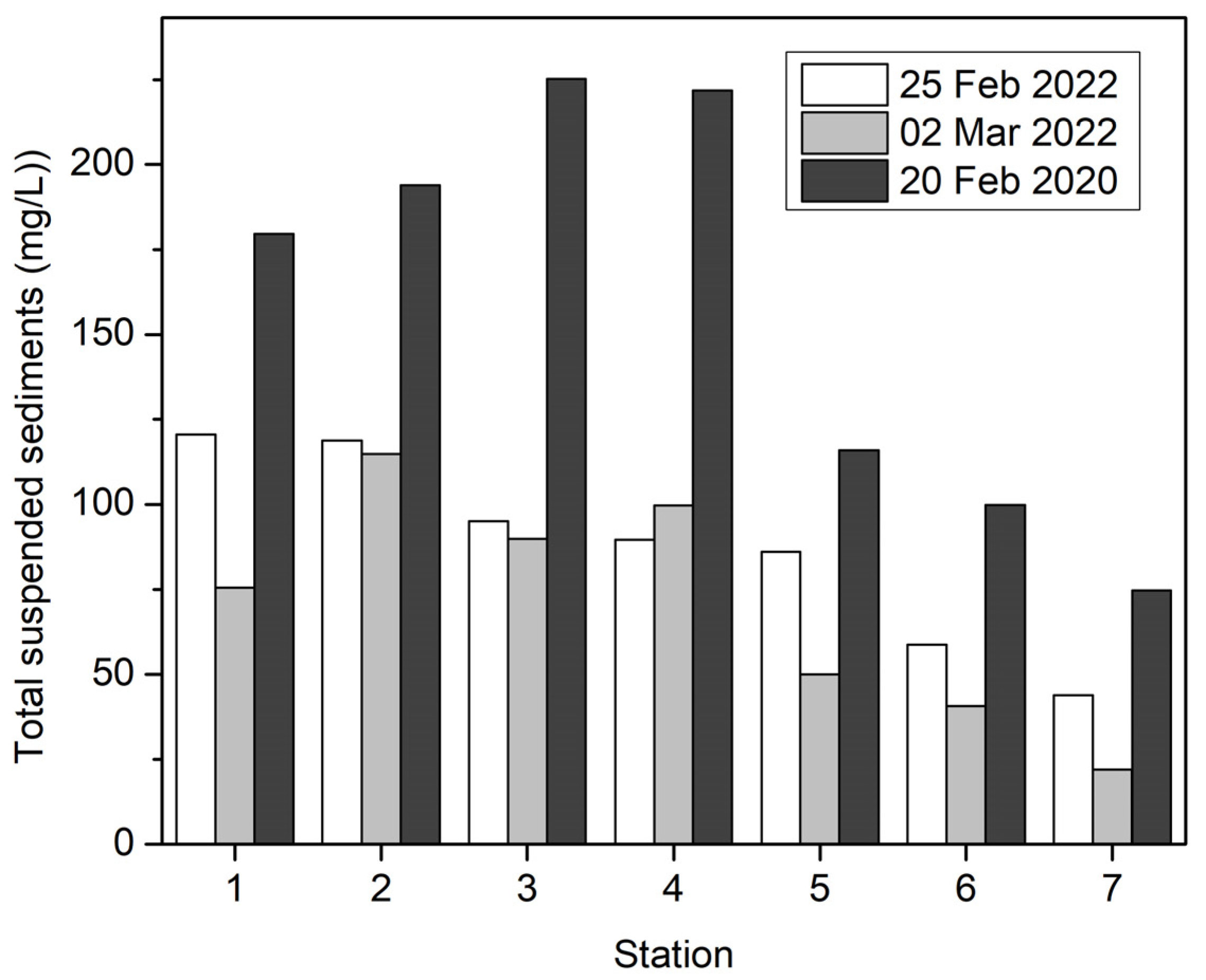
3.1. Total Suspended Sediment and Arsenic in Pasig River
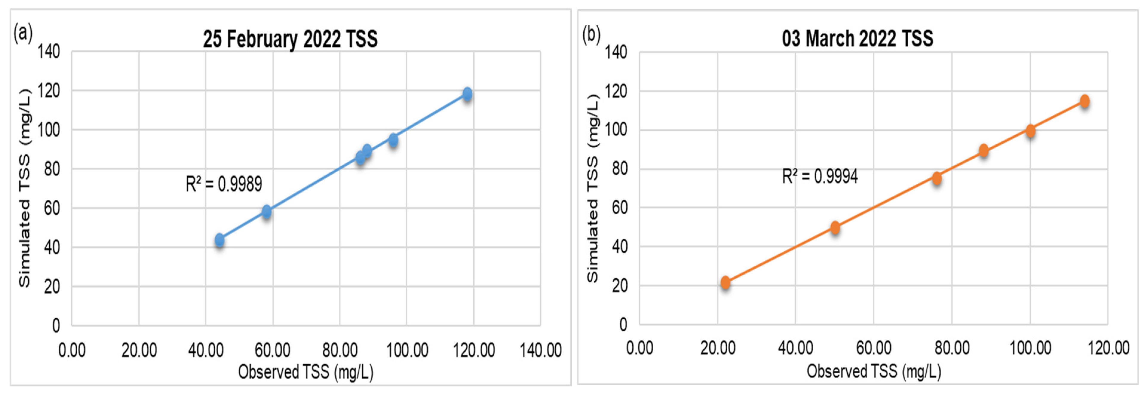
3.2. Flow and Sediment Model Calibration and Validation
3.3. 2020 Model Development and Simulation Results
4. Conclusions
- (1)
- Use of other software to investigate the same case as the current study and compare its findings to observed data.
- (2)
- Conduct more field measurements and perform simulations using the present model under different conditions, climatological data, water level, and discharge as input.
- (3)
- Study the same case simulations at much earlier dates prior to the volcanic eruption using the present model.
Author Contributions
Funding
Data Availability Statement
Acknowledgments
Conflicts of Interest
References
- UN Office for the Coordination of Human Affairs [OCHA]. Philippines: Taal Volcano Eruption Displacement Snapshot (As of 15 January 2020). Reliefweb. Available online: https://reliefweb.int/report/philippines/philippines-taal-volcano-eruption-displacement-snapshot-15-january-2020 (accessed on 10 October 2022).
- UN Office for the Coordination of Human Affairs [OCHA]. Philippines: 2020 Significant Events Snapshot (As of 14 January 2021). Reliefweb. Available online: https://reliefweb.int/report/philippines/philippines-2020-significant-events-snapshot-14-january-2021 (accessed on 10 October 2022).
- Manila Observatory. Impacts of Taal Volcano Phreatic Eruption (12 January 2020) on the Environment and Population: Satellite-Based Observations Compared with Historical Records. Available online: https://www.observatory.ph/2020/04/20/impacts-of-taal-volcano-phreatic-eruption-12-january-2020-on-the-environment-and-population-satellite-based-observations-compared-with-historical-records/ (accessed on 13 January 2022).
- International Federation of Red Cross and Red Crescent Societies [IFRC]. Philippines: Taal Volcano Eruption—Final Report. Reliefweb. Available online: https://reliefweb.int/report/philippines/philippines-taal-volcano-eruption-final-report-n-mdrph043 (accessed on 10 October 2022).
- Thouret, J.-C.; Oehler, J.-F.; Gupta, A.; Solikhin, A.; Procter, J.N. Erosion and Aggradation on Persistently Active Volcanoes—A Case Study from Semeru Volcano, Indonesia. Bull. Volcanol. 2014, 76, 857. [Google Scholar] [CrossRef]
- Pickarski, N.; Kwiecien, O.; Litt, T. Volcanic Impact on Terrestrial and Aquatic Ecosystems in the Eastern Mediterranean. Commun. Earth Environ. 2023, 4, 167. [Google Scholar] [CrossRef]
- Lim, J.A. The Philippine Economy during the COVID Pandemic; Ateneo Center for Economic Research and Development, Ateneo de Manila University: Quezon City, Philippines, 2020. [Google Scholar]
- Santos, J.; Roquel, K.I.D.Z.; Lamberte, A.; Tan, R.R.; Aviso, K.B.; Tapia, J.F.D.; Solis, C.A.; Yu, K.D.S. Assessing the Economic Ripple Effects of Critical Infrastructure Failures Using the Dynamic Inoperability Input-Output Model: A Case Study of the Taal Volcano Eruption. Sustain. Resilient Infrastruct. 2023, 8, 68–84. [Google Scholar] [CrossRef]
- National Economic and Development Authority [NEDA] Region IV-A. CALABARZON Rehabilitation and Recovery Program for Taal Volcano Eruption. Available online: https://serp-p.pids.gov.ph/publication/public/view?slug=calabarzon-rehabilitation-and-recovery-program-for-taal-volcano-eruption (accessed on 22 November 2022).
- Ancheta, J.R.; Gamayo, G.V. Women in Disasters: Unfolding the Struggles of Displaced Mothers in Talisay, Batangas during the Taal Volcano Eruption and the Pandemic. Rupkatha 2022, 14, 1–10. [Google Scholar] [CrossRef]
- Lebrato, M.; Wang, Y.V.; Tseng, L.-C.; Achterberg, E.P.; Chen, X.-G.; Molinero, J.-C.; Bremer, K.; Westernströer, U.; Söding, E.; Dahms, H.-U.; et al. Earthquake and Typhoon Trigger Unprecedented Transient Shifts in Shallow Hydrothermal Vents Biogeochemistry. Sci. Rep. 2019, 9, 16926. [Google Scholar] [CrossRef] [PubMed]
- Lallement, M.; Macchi, P.J.; Vigliano, P.; Juarez, S.; Rechencq, M.; Baker, M.; Bouwes, N.; Crowl, T. Rising from the Ashes: Changes in Salmonid Fish Assemblages after 30 Months of the Puyehue–Cordon Caulle Volcanic Eruption. Sci. Total Environ. 2016, 541, 1041–1051. [Google Scholar] [CrossRef] [PubMed]
- Lacaux, J.P.; Tourre, Y.M.; Vignolles, C.; Ndione, J.A.; Lafaye, M. Classification of Ponds from High-Spatial Resolution Remote Sensing: Application to Rift Valley Fever Epidemics in Senegal. Remote Sens. Environ. 2007, 106, 66–74. [Google Scholar] [CrossRef]
- Siringan, F.P.; Racasa, E.D.R.; David, C.P.C.; Saban, R.C. Increase in Dissolved Silica of Rivers Due to a Volcanic Eruption in an Estuarine Bay (Sorsogon Bay, Philippines). Estuaries Coast 2018, 41, 2277–2288. [Google Scholar] [CrossRef]
- Hayes, S.K.; Montgomery, D.R.; Newhall, C.G. Fluvial Sediment Transport and Deposition Following the 1991 Eruption of Mount Pinatubo. Geomorphology 2002, 45, 211–224. [Google Scholar] [CrossRef]
- Manzella, I.; Bonadonna, C.; Phillips, J.C.; Monnard, H. The Role of Gravitational Instabilities in Deposition of Volcanic Ash. Geology 2015, 43, 211–214. [Google Scholar] [CrossRef]
- Rose, W.I.; Durant, A.J. Fine Ash Content of Explosive Eruptions. J. Volcanol. Geotherm. Res. 2009, 186, 32–39. [Google Scholar] [CrossRef]
- Eliasson, J. New Model for Dispersion of Volcanic Ash and Dust in the Troposphere. Int. J. Geosci. 2020, 11, 544–561. [Google Scholar] [CrossRef]
- Cruz, M.T.; Simpas, J.B.; Holz, R.; Yuan, C.-S.; Bagtasa, G. Characteristics of Particulate Matter during New Year’s Eve Fireworks and Taal Volcano Ashfall in Metro Manila on January 2020. Urban Clim. 2023, 50, 101587. [Google Scholar] [CrossRef]
- Trenberth, K.E.; Dai, A. Effects of Mount Pinatubo Volcanic Eruption on the Hydrological Cycle as an Analog of Geoengineering. Geophys. Res. Lett. 2007, 34, L15702. [Google Scholar] [CrossRef]
- Lagmay, A.M.F.; Balangue-Tarriela, M.I.R.; Aurelio, M.; Ybañez, R.; Bonus-Ybañez, A.; Sulapas, J.; Baldago, C.; Sarmiento, D.M.; Cabria, H.; Rodolfo, R.; et al. Hazardous Base Surges of Taal’s 2020 Eruption. Sci. Rep. 2021, 11, 15703. [Google Scholar] [CrossRef]
- Balangue-Tarriela, M.I.R.; Lagmay, A.M.F.; Sarmiento, D.M.; Vasquez, J.; Baldago, M.C.; Ybañez, R.; Ybañez, A.A.; Trinidad, J.R.; Thivet, S.; Gurioli, L.; et al. Analysis of the 2020 Taal Volcano Tephra Fall Deposits from Crowdsourced Information and Field Data. Bull. Volcanol. 2022, 84, 35. [Google Scholar] [CrossRef] [PubMed]
- Belo, L.P. Measurement of the Sediment Oxygen Demand in Selected Stations of the Pasig River Using a Bench-Scale Benthic Respirometer. Master’s Thesis, Environmental Engineering and Management–De La Salle University, Manila, Philippines, October 2008. [Google Scholar]
- Joshi, N.; Lamichhane, G.R.; Rahaman, M.M.; Kalra, A.; Ahmad, S. Application of Hec-Ras to Study the Sediment Transport Characteristics of Maumee River in Ohio. In Proceedings of the World Environmental and Water Resources Congress 2019, Pittsburgh, Pennsylvania, 19–23 May 2019; American Society of Civil Engineers: Reston, VA, USA, 2019; pp. 257–267. [Google Scholar]
- Akhtar, M.N.; Anees, M.T.; Bakar, E.A. Assessment of the Effect of High Tide and Low Tide Condition on Stream Flow Velocity at Sungai Rompin’s Mouth. In Proceedings of the IOP Conference Series: Materials Science and Engineering, 6th International Conference of Global Network for Innovative Technology (IGNITE), Penang, Malaysia, 2–3 December 2019. [Google Scholar]
- Willmott, C.J. On the Validation of Models. Phys. Geogr. 1981, 2, 184–194. [Google Scholar] [CrossRef]
- Legates, D.R.; McCabe, G.J. Evaluating the Use of “Goodness-of-fit” Measures in Hydrologic and Hydroclimatic Model Validation. Water Resour. Res. 1999, 35, 233–241. [Google Scholar] [CrossRef]
- Nash, J.E.; Sutcliffe, J.V. River Flow Forecasting through Conceptual Models Part I—A Discussion of Principles. J. Hydrol. 1970, 10, 282–290. [Google Scholar] [CrossRef]
- Harmel, R.D.; Smith, P.K.; Migliaccio, K.W. Modifying Goodness-of-Fit Indicators to Incorporate Both Measurement and Model Uncertainty in Model Calibration and Validation. Trans. ASABE 2010, 53, 55–63. [Google Scholar] [CrossRef]
- Moriasi, D.N.; Arnold, J.G.; Liew, M.W.V.; Bingner, R.L.; Harmel, R.D.; Veith, T.L. Model Evaluation Guidelines for Systematic Quantification of Accuracy in Watershed Simulations. Trans. ASABE 2007, 50, 885–900. [Google Scholar] [CrossRef]
- Gupta, H.V.; Sorooshian, S.; Yapo, P.O. Status of Automatic Calibration for Hydrologic Models: Comparison with Multilevel Expert Calibration. J. Hydrol. Eng. 1999, 4, 135–143. [Google Scholar] [CrossRef]
- Hague, B.S.; Grayson, R.B.; Talke, S.A.; Black, M.T.; Jakob, D. The effect of tidal range and mean sea-level changes on coastal flood hazards at Lakes Entrance, south-east Australia. J. South. Hemisph. Earth Syst. Sci. 2023, 73, 116–130. [Google Scholar] [CrossRef]
- Alharbi, T.; Al-Kahtany, K.; Nour, H.E.; Giacobbe, S.; El-Sorogy, A.S. Contamination and health risk assessment of arsenic and chromium in coastal sediments of Al-Khobar area, Arabian Gulf, Saudi Arabia. Mar. Pollut. Bull. 2022, 185, 114255. [Google Scholar] [CrossRef] [PubMed]
- Bia, G.; García, M.G.; Cosentino, N.J.; Borgnino, L. Dispersion of arsenic species from highly explosive historical volcanic eruptions in Patagonia. Sci. Total Environ. 2022, 853, 158389. [Google Scholar] [CrossRef] [PubMed]
- Irnawati, I.; Idroes, R.; Zulfiani, U.; Akmal, M.; Suhartono, E.; Idroes, G.M.; Muslem, M.; Lala, A.; Yusuf, M.; Saiful, S.; et al. Assessment of Arsenic Levels in Water, Sediment, and Human Hair around Ie Seu’um Geothermal Manifestation Area, Aceh, Indonesia. Water 2021, 13, 2343. [Google Scholar] [CrossRef]
- Birkle, P.; Bundschuh, J.; Sracek, O. Mechanisms of arsenic enrichment in geothermal and petroleum reservoirs fluids in Mexico. Water Res. 2010, 44, 5605–5617. [Google Scholar] [CrossRef]
- Hama, T.; Ito, H.; Kawagoshi, Y.; Nakamura, K.; Kubota, T. Natural Attenuation and Remobilization of Arsenic in a Small River Contaminated by the Volcanic Eruption of Mount Iou in Southern Kyushu Island, Japan. J. Hazard. Mater. 2023, 455, 131576. [Google Scholar] [CrossRef]
- Apostol, G.L.C.; Valenzuela, S.; Seposo, X. Arsenic in Groundwater Sources from Selected Communities Surrounding Taal Volcano, Philippines: An Exploratory Study. Earth 2022, 3, 448–459. [Google Scholar] [CrossRef]
- US Army Corps of Engineers [USACE]. HEC-RAS 1D Sediment Transport Technical Reference Manual. Available online: https://www.hec.usace.army.mil/confluence/rasdocs/rassed1d (accessed on 20 October 2022).
- Dasallas, L.; An, H.; Lee, S. Developing an integrated multiscale rainfall-runoff and inundation model: Application to an extreme rainfall event in Marikina-Pasig River Basin, Philippines. J. Hydrol. Reg. Stud. 2022, 39, 100995. [Google Scholar] [CrossRef]
- Escoto, J.E.; Blanco, A.C.; Argamosa, R.J.; Medina, J.M. Pasig River Water Quality Estimation Using an Empirical Ordinary Least Squares Regression Model of Sentinel-2 Satellite Images. Int. Arch. Photogramm. Remote Sens. Spat. Inf. Sci. 2021, 46, 161–168. [Google Scholar] [CrossRef]
- Paronda, G.R.A.; David, C.P.C.; Apodaca, D.C. River Flow Pattern and Heavy Metals Concentrations in Pasig River, Philippines as Affected by Varying Seasons and Astronomical Tides. In Proceedings of the IOP Conference Series: Earth and Environmental Science, the 5th International Conference on Water Resource and Environment (WRE) 2019, Macao, China, 16–19 July 2019. [Google Scholar]
- Kataoka, K.S.; Matsumoto, T.; Saito, T.; Nagahashi, Y.; Iyobe, T. Suspended Sediment Transport Diversity in River Catchments Following the 2014 Phreatic Eruption at Ontake Volcano, Japan. Earth Planets Space 2019, 71, 15. [Google Scholar] [CrossRef]
- Major, J.J. Post-Eruption Hydrology and Sediment Transport in Volcanic River Systems. Water Resour. Impact 2003, 5, 10–15. [Google Scholar]
- Gran, K.B.; Montgomery, D.R.; Halbur, J.C. Long-Term Elevated Post-Eruption Sedimentation at Mount Pinatubo, Philippines. Geology 2011, 39, 367–370. [Google Scholar] [CrossRef]
- Casila, J.C.; Dimapilis, D.A.; Limbago, J.S.; Delos Reyes, A.A., Jr.; Casila, E.B.; Haddout, S. Characterization and Quantification of Surficial Sediment Microplastics and Its Correlation with Heavy Metals, Soil Texture, and Flow Velocity. Anal. Lett. 2023. [Google Scholar] [CrossRef]
- Mababa, S.J.; Apodaca, D.C.; David, C.P.C. Development of an acute sediment toxicity test using an endemic benthic macroinvertebrate, Chironomus species to assess the toxicity of Philippines’ Pasig River sediments. IOP Conf. Ser. Earth Environ. Sci. 2018, 191, 012140. [Google Scholar] [CrossRef]
- Taal Volcano Summary of 24Hr Observation 11 January 2024 12:00 AM. Reliefweb. Available online: https://www.phivolcs.dost.gov.ph/index.php/volcano-hazard/volcano-bulletin2/taal-volcano/22213-taal-volcano-summary-of-24hr-observation-11-january-2024-12-00-am (accessed on 17 January 2024).
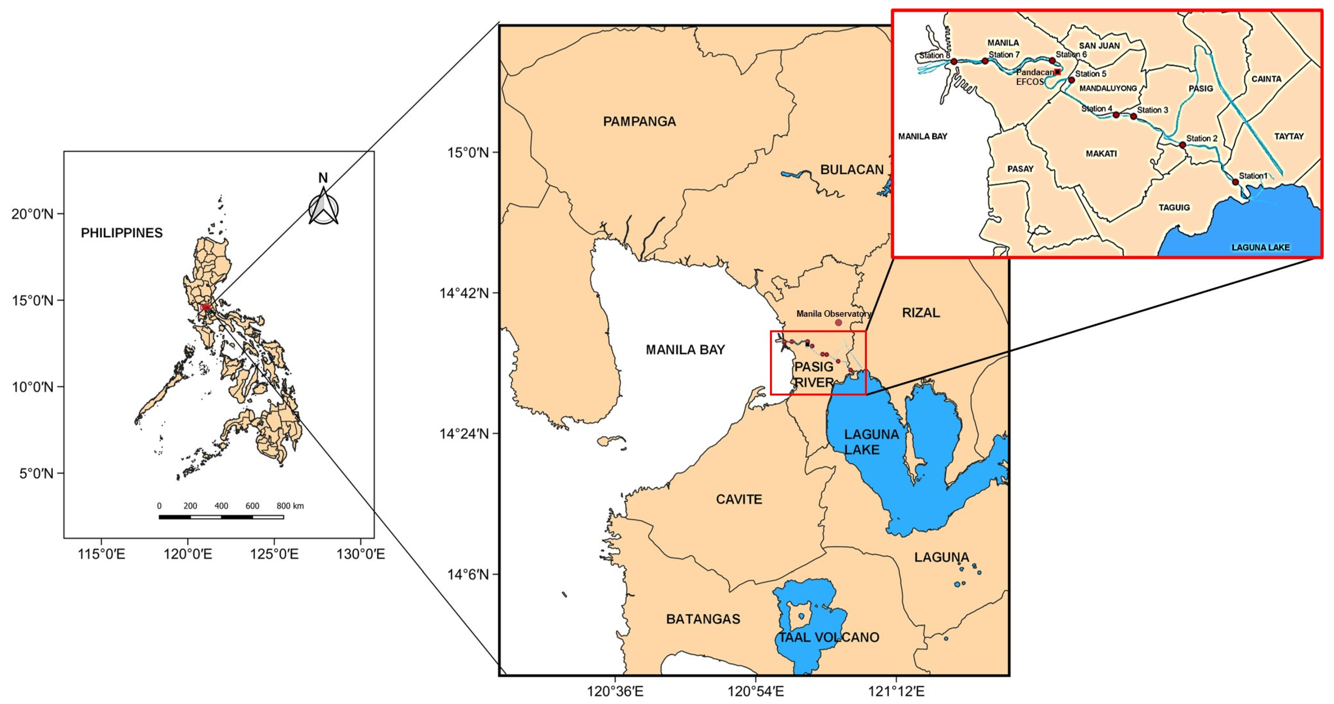
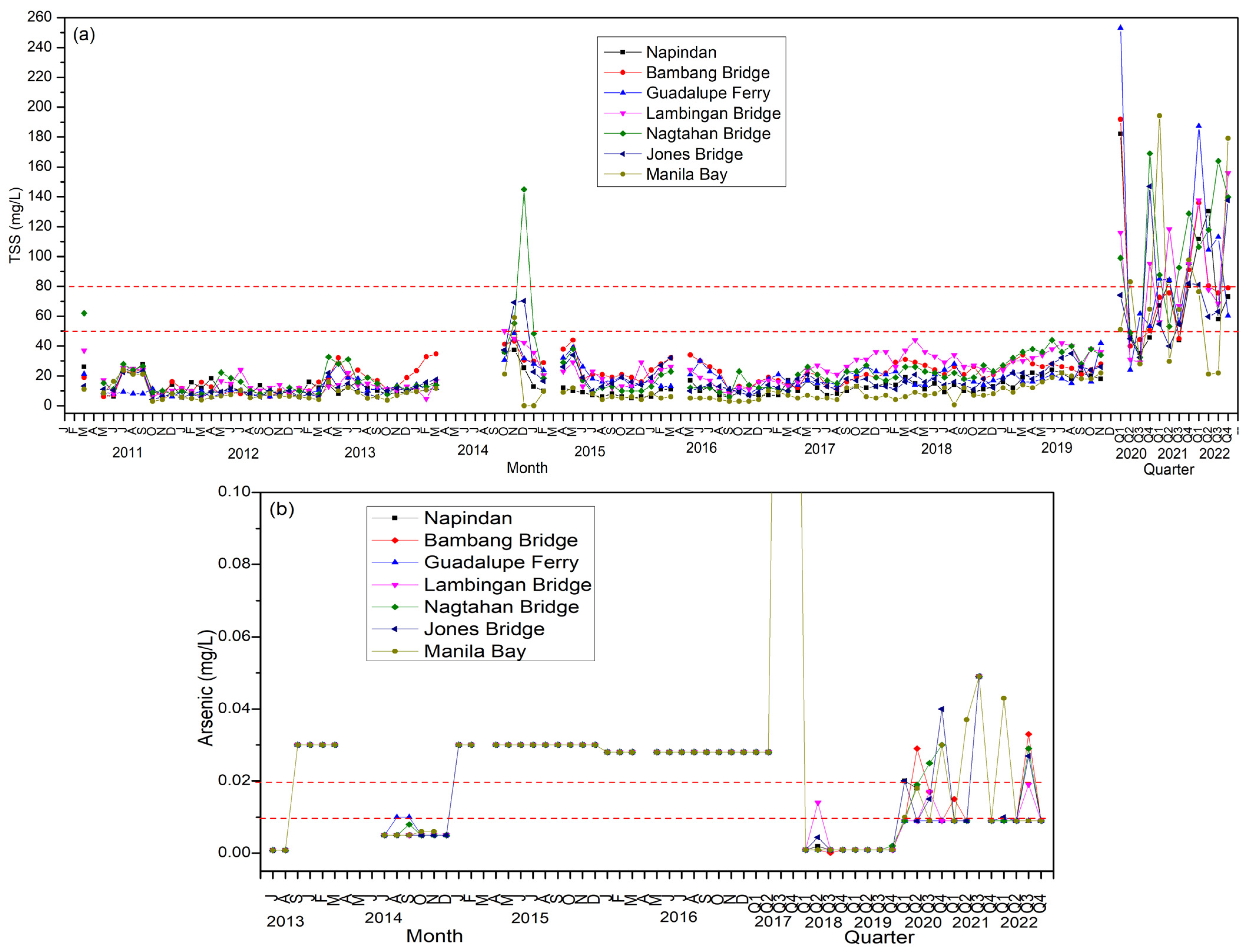
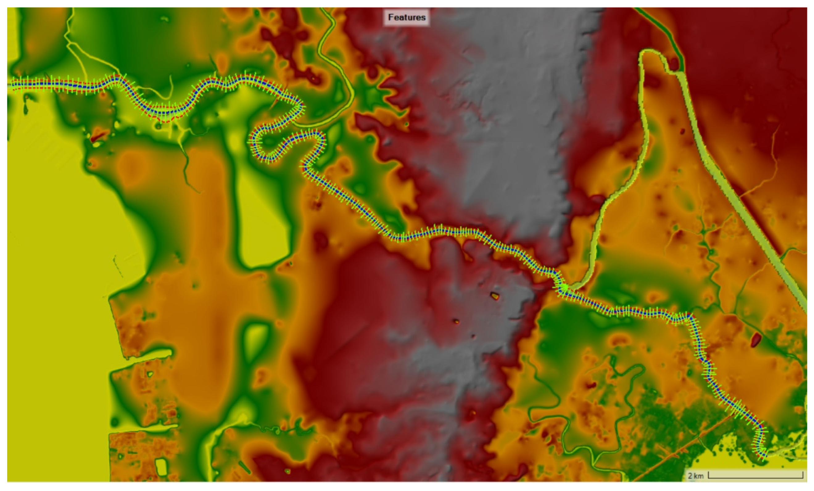
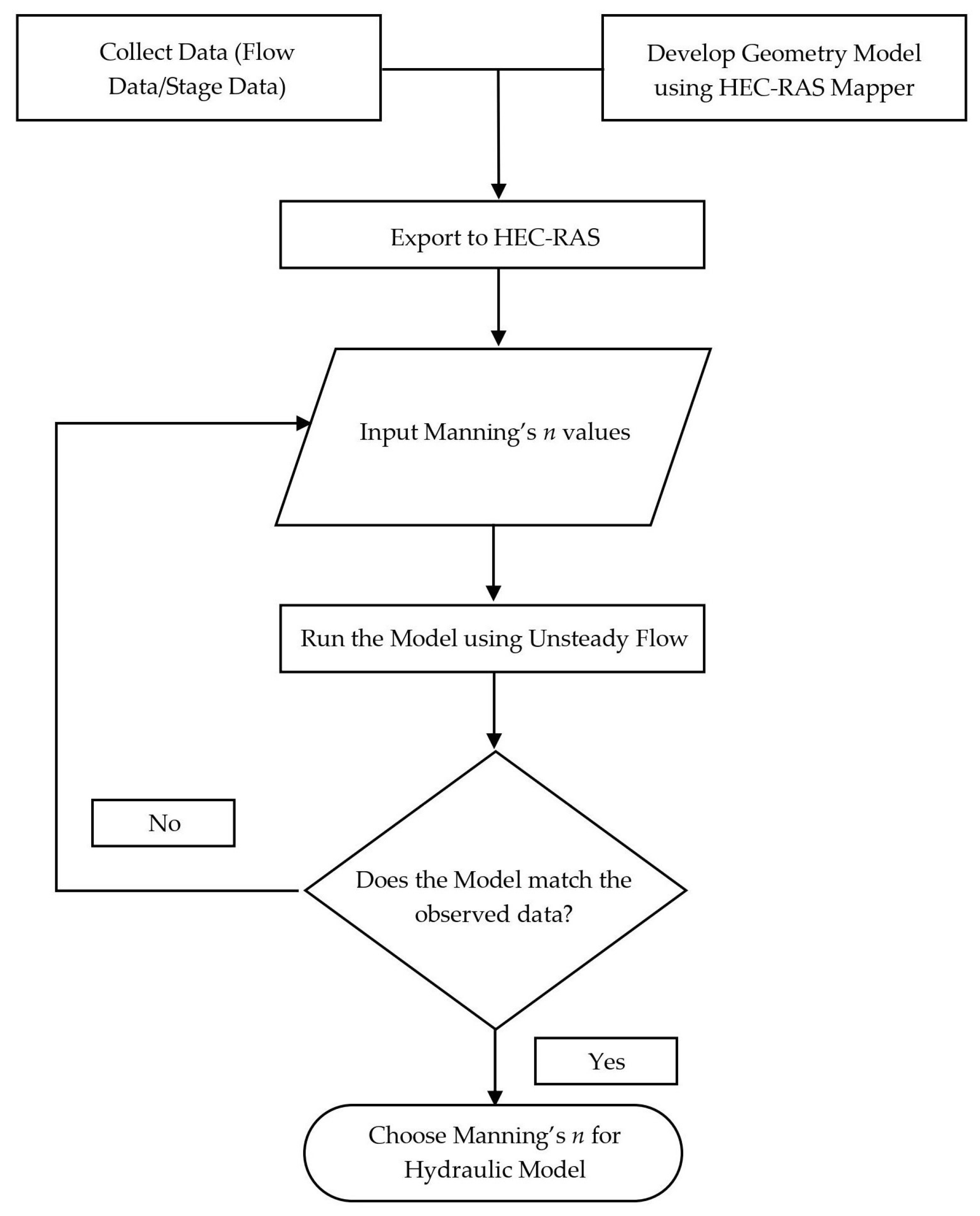


| Station | Latitude | Longitude | |
|---|---|---|---|
| 1 | Napindan (C6) Bridge | 14.5351 | 121.1022 |
| 2 | Bambang Bridge | 14.5536 | 121.0759 |
| 3 | Buayang Bato | 14.5683 | 121.0510 |
| 4 | Guadalupe Viejo | 14.5682 | 121.0410 |
| 5 | Lambingan Bridge | 14.5865 | 121.0198 |
| 6 | Nagtahan Bridge | 14.5959 | 121.0012 |
| 7 | Jones Bridge | 14.5958 | 120.9771 |
| 8 | Manila Bay | 14.5955 | 120.9618 |
| Statistical Index | Calibration 25 February 2022 | Validation | Optimal Value | |
|---|---|---|---|---|
| 25 February 2022 | 2 March 2022 | |||
| R2 | 0.9950 | 0.9989 | 0.9994 | 1 |
| d | 0.9983 | 0.9997 | 0.9998 | 1 |
| NSE | 0.9931 | 0.9986 | 0.9991 | 0.75–1 |
| PBIAS | 1.2915 | −0.4476 | −0.4607 | −15–0–15 |
| RSR | 0.0832 | 0.0369 | 0.0285 | 0.5–0 |
| Statistical Index | Calibration | Optimal Value |
|---|---|---|
| R2 | 0.9994 | 1 |
| d | 0.9999 | 1 |
| NSE | 0.99937 | 0.75–1 |
| PBIAS | −0.06997 | −15–0–15 |
| RSR | 0.02496 | 0.5–0 |
Disclaimer/Publisher’s Note: The statements, opinions and data contained in all publications are solely those of the individual author(s) and contributor(s) and not of MDPI and/or the editor(s). MDPI and/or the editor(s) disclaim responsibility for any injury to people or property resulting from any ideas, methods, instructions or products referred to in the content. |
© 2024 by the authors. Licensee MDPI, Basel, Switzerland. This article is an open access article distributed under the terms and conditions of the Creative Commons Attribution (CC BY) license (https://creativecommons.org/licenses/by/4.0/).
Share and Cite
Casila, J.C.; Andres, H.L.; Haddout, S.; Yokoyama, K. Sediment Transport Modeling in the Pasig River, Philippines Post Taal Volcano Eruption. Geosciences 2024, 14, 45. https://doi.org/10.3390/geosciences14020045
Casila JC, Andres HL, Haddout S, Yokoyama K. Sediment Transport Modeling in the Pasig River, Philippines Post Taal Volcano Eruption. Geosciences. 2024; 14(2):45. https://doi.org/10.3390/geosciences14020045
Chicago/Turabian StyleCasila, Joan Cecilia, Howard Lee Andres, Soufiane Haddout, and Katsuhide Yokoyama. 2024. "Sediment Transport Modeling in the Pasig River, Philippines Post Taal Volcano Eruption" Geosciences 14, no. 2: 45. https://doi.org/10.3390/geosciences14020045
APA StyleCasila, J. C., Andres, H. L., Haddout, S., & Yokoyama, K. (2024). Sediment Transport Modeling in the Pasig River, Philippines Post Taal Volcano Eruption. Geosciences, 14(2), 45. https://doi.org/10.3390/geosciences14020045


