Abstract
Situated throughout the southeastern United States within the Laurentian craton are occurrences of various aged deposits (Late Proterozoic to Early Paleogene) that contain volcanics spanning from lamprophyres to carbonatites and basalts to rhyolites. Several are intrusive, while others have been reworked detritally, deposited as river gravels out onto the Gulf Coastal Plain. The earliest occurrence of igneous gravel clasts in the coastal plain of the lower Mississippi Valley lie along the Mississippi River’s eastern valley wall in the ancestral Mississippi River’s pre-loess terrace deposits (PLTDs). The coarse clastics of the PLTDs are dominantly chert gravels derived from Paleozoic carbonate bedrock, but also include clasts of Precambrian Sioux Quartzite, glacially faceted and striated stones, and ice-rafted boulders, which indicate a direct relationship between the PLTDs and glacial outwash during the cyclic glaciation of the Pleistocene Epoch. The PLTDs also contain the oldest known examples of igneous gravels exposed at the surface in Mississippi. An understanding of their igneous bedrock provenance and the timing of their contribution to the sedimentary record of the lower Mississippi River Valley sheds a valuable light onto the geologic history and evolution of the ancestral Mississippi River during the Pleistocene Epoch. The use of fusion inductively coupled plasma mass-spectroscopy (ICP-MS) in the identification of the igneous suites of one of the pre-loess terraces, well-delineated by geologic mapping, adds important geochemical source data from the gravel constituents for the further interpretation and correlation of the individual PLTD allounits. Gravel constituent geochemistry also offers a better understanding of the evolution of the ancestral Mississippi River watershed and the contributions of bedrock sources during Pleistocene glaciation. This petrological study suggests that the igneous gravels sampled from within the Rawhide PLTD allounit originated from the St. Francois Mountains (SFMs) in southwestern Missouri, with the implications that the SFM igneous terrain was in the direct path of the Independence “Kansan” glaciation. This could indicate a glacial extent further southwest than previously documented.
1. Introduction
1.1. Volcanic Materials in the Mississippi River Basin (MRB) and Mississippi Embayment (MSE)
The North American midcontinent within the MRB has suites of volcanic materials that range in age from the Late Proterozoic (~2500–540 Ma) to the Late Cretaceous, and, in places, into the Early Paleogene (~110–23 Ma) (e.g., [1,2,3,4,5,6,7,8,9]). These volcanic suites include basalts with peridotite xenoliths, lamprophyres, kimberlites, trachytes, phonolites, rhyolites, and carbonatites [1,2,3,4,5,6,7,8]. Volcanics are found in outcrops at the surface or are known through drill core logs, while a rare subset of detritally emplaced igneous materials of volcanic origin is found in gravel suites deposited by fluvial transport into the coastal plain of the Northern Gulf of Mexico via the MRB. One such occurrence of volcanic gravels resides in ancestral Mississippi River terraces that are mid-Pleistocene in age. These gravels make up the pre-loess strata of the pre-loess terrace deposits (PLTDs) along the eastern axis of the MSE [1,2,3,4,5,6,7,8]. Currently, PLTDs are only described in the state of Mississippi (MS; Figure 1) and will become the basis for the applications of further study in surrounding states within the MRB and MSE [1,2,3,4,5,6,7,8]. The volcanic gravels found in the PLTDs are of curious origin. This article attempts to describe and discuss the origins of fluvially transported volcanic clasts found in the PLTDs and relate them to glacial processes during the Pleistocene.
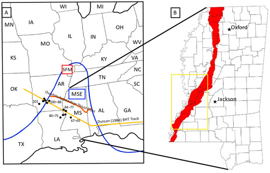
Figure 1.
(A) MSE (outlined in blue) with volcanics and structures labeled within the central and eastern states of the continental US. Igneous ages in and around the MSE are reported in millions of years and come from a large data set reported by [10]. Also shown is the hypothesized Bermuda Hotspot track (BHT) from [11], shown in yellow; the Ouachita–Appalachian thrust front, shown in orange [12], after [12]; SFM—St. Francois Mountains. (B) State boundary of MS with Jackson (the state capital), Oxford (the location of the University of Mississippi), and county boundaries showing Pleistocene PLTDs (red), and indicating completed mapping (e.g., [6,7,13]) within the PLTDs (yellow box) and sampling locations over the last 25 years (small green dots in Warren and Yazoo counties).
1.2. The Pre-Loess Terrace Deposits of the Lower Mississippi River Valley and Glacial Associations
The MRB as a whole has evolved dramatically between the Late Pliocene and Late Pleistocene, both in its watershed in its upper valley and in its position in its lower valley across the coastal plain, leading up to its current entrenchment entering the Gulf of Mexico. The lower river valley (LRV) approximates the axis of the MSE, and the earliest stream terraces attributable to the ancestral Mississippi River in the Gulf Coastal Plain are on the eastern flank of the MSE (e.g., [6,7,13,14]). This is recorded as thick graveliferous terrace deposits perched 400 feet above mean sea level (msl) in southcentral MS, well east of the Mississippi River’s current entrenchment [14]. These terraces have intervals that descend southwestward with at least two well-preserved terrace treads at ~550 and ~500 feet above msl [6,7,14]. They have been recognized in more recent geologic mapping by the ongoing work of the state geological survey. These pre-Pleistocene terraces (Figure 2) are being mapped as alloformations with type localities at the Magee Airport in Simpson County, MS, and in the area that encompasses the city of Brookhaven in Lincoln County, MS, respectively, with the Pearl River occupying the boundary between them [14]. These early river terraces have been attributed to the evolution of the Mississippi River in the eastern Gulf Coastal Plain and are designated as Pliocene in age (e.g., [6,7,13,15,16,17,18]). Earlier mapping formerly misattributed the fluvial terraces in MS, including the Brookhaven and Magee Airport Terraces, to the “Citronelle Formation” by Morse [19] and later authors (e.g., [20,21]), a nomen dubium long used by geologic mappers for undifferentiated coastal plain coarse clastics from Florida to Texas (Figure 2; [5,6,14,22]). The Brookhaven and Magee Airport Terraces contain a distinctive bimodal distribution of clastic petrology of quartz sand and chert gravels derived from Paleozoic marine carbonates of the midcontinent that range up to cobble-sized clasts, rarely exceeding 6 cm in length [6,13,14,15]. This is consistent with a pre-glacial configuration of the ancestral Mississippi River, whose watershed would have been dominated by the regions of the Ohio and Tennessee River Valleys, draining Paleozoic carbonate bedrock along the northern flank of the Appalachians.
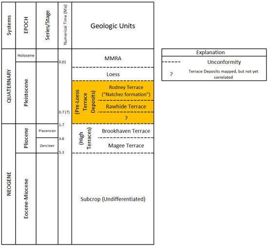
Figure 2.
A stratigraphic column of the Neogene to the Holocene after Dockery [5,23] showing the temporal relationship between the modern Mississippi River alluvium (MMRA), loess, the PLTDs (highlighted in yellow), and, at higher elevations, the Brookhaven and Magee Airport Terraces.
With the later onset of glacial–interglacial cycles during the Pleistocene Epoch and the resulting eustatic sea level changes, the ancestral Mississippi River continued stepping westward toward the axis of the MSE and incising itself deeper into the coastal plain. This left behind a series of extensive river terrace deposits along its eastern valley wall, designated as PLTDs. The pre-loess terrace levels extend to the border of the Mississippi River’s current entrenchment. The river’s current entrenchment formed during the height of the Last Glacial Maximum (LGM; ~0.12–0.01 Ma), and the subsequent alluviation of the river valley followed, transitioning into the Holocene Epoch [6,13,14,15]. The ancestral Mississippi River PLTDs occupy the bluffs overlooking the eastern valley wall of the Mississippi River Alluvial Plain from north of Memphis, Tennessee, along a roughly north–south belt throughout western MS and south of Natchez into Louisiana [6,22]. The distribution of the pre-loess terraces approximates the physiographic region of the Loess Bluffs belt [6,22]. The river’s bluffs terminate south, nearing where the Loess Bluffs give way to the distributaries of the Mississippi River Alluvial Plain as it enters the Gulf of Mexico [6,22].
In MS, the PLTDs contain common glacial clastic material (e.g., Sioux Quartzite), the anomalous subset of volcanic clasts (described in this article), and are largely masked by a thick blanket of eolian loess derived from fine-grained outwash sediments across the Mississippi River Alluvial Plain [6,7,13,15,22]. The closest exposures of bedrock that present probable sources for the volcanic clasts present in the PLTDs within the MRB are the ancient volcanic complex of the St. Francois Mountains in southeastern Missouri (Figure 3; [6,14,22]). Meltwaters from ice dam breaks have been proposed to have carried igneous rocks from the St. Francois region southward down the ancestral Mississippi River [13,15], but definitive proof of this connection is lacking. Subsequent glacial episodes caused the Mississippi River to cut a deeper valley, abandoning its alluvial remnants as terraces of the old courses along the high bluffs, leaving behind a series of PLTDs [15]. At the end of the LGM, the ice sheets receded for the last time into the Arctic, and the Mississippi River filled its valley with sediment to where it is today [9,13,15,24,25]. Ages from pulmonate gastropod shell fragments corroborate this [25]. Radiometric carbon dates by Starnes and Leard [25] from a core in Jefferson County, MS, show calibrated ages from both the lowest pre-loess terrace and basal loess at ~29,275–~18,801 years before present (YBP), which is consistent with the abandonment of the river’s first terrace and the subsequent loessification. The burying of the terrace occurred near the height of the LGM. This constrains the ages of all features in the alluvial plain of the Mississippi River in the Yazoo Basin to no older than the LGM.
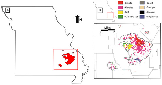
Figure 3.
(A) State of Missouri with the outline of the St. Francois Mountain (SFM) region (red). (B) Inset of the SFM region igneous suites (colored explanation), where white is modern alluvium, as identified in du Bray et al. [8].
Mapping projects conducted by the Mississippi Geological Survey [6,7,13,16,17,18,26] on the PLTDs in MS demonstrate an unmistakable relationship with the outwash of the Pleistocene glacial margins to the north in the watershed of the Mississippi River. These include glacially faceted, polished, and striated clasts (Figure 4); angular and ice-abraded clasts (Figure 5); and even ice-rafted boulder erratics, including Paleozoic chert boulders weighing well over a ton (Figure 5). The identification of chert gravel fossils and certain other rock types within the PLTDs can be attributed to specific midcontinent bedrock source regions. Comparing these coarse clastic gravel suites between terrace intervals demonstrates the shifting of bedrock contributions and alterations of the Mississippi River watershed drainages during glacial cycles. An example of this is the identification of Sioux Quartzite within the pre-loess terrace gravels, which originates from the Precambrian bedrock regions of Minnesota and the Dakotas [15]. The presence of these clasts within the pre-loess terraces demonstrates the shifting and re-routing of the Missouri River drainage, adding western bedrock material sources into the lower Mississippi Valley along glacial margins in the “Old Drift” area of Kansas and Missouri [15]. Looking to other parts of the lower valley of the Mississippi River, the identification of Sioux Quartzite clasts (Figure 6) has helped to equate the PLTDs more generally to other Mississippi River-related terraces along the western valley wall of the Mississippi River, such as the gravels along Crowley’s Ridge of Arkansas (AR) and the Mounds/Grover gravels of Missouri (e.g., [6,13,15,16,17,18,22,25,27,28]). Sioux Quartzite was yet available to the Mississippi River Valley watershed until the blocking and re-routing of the Missouri River by a pre-Illinoisan glacial advance, formerly referred to as the “Kansan” glaciation, but is now considered as Independence glaciation, which corresponds to Marine Isotope Stage (MIS) 16–20 >600,000 years ago (e.g., [6,13,15,22,25,27,28,29]). Ongoing detailed geologic mapping and test-hole drilling conducted by the Mississippi Geological Survey have further delineated the pre-loess terraces into formal individual and correlateable allostratigraphical terrace units (Figure 2).
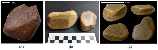
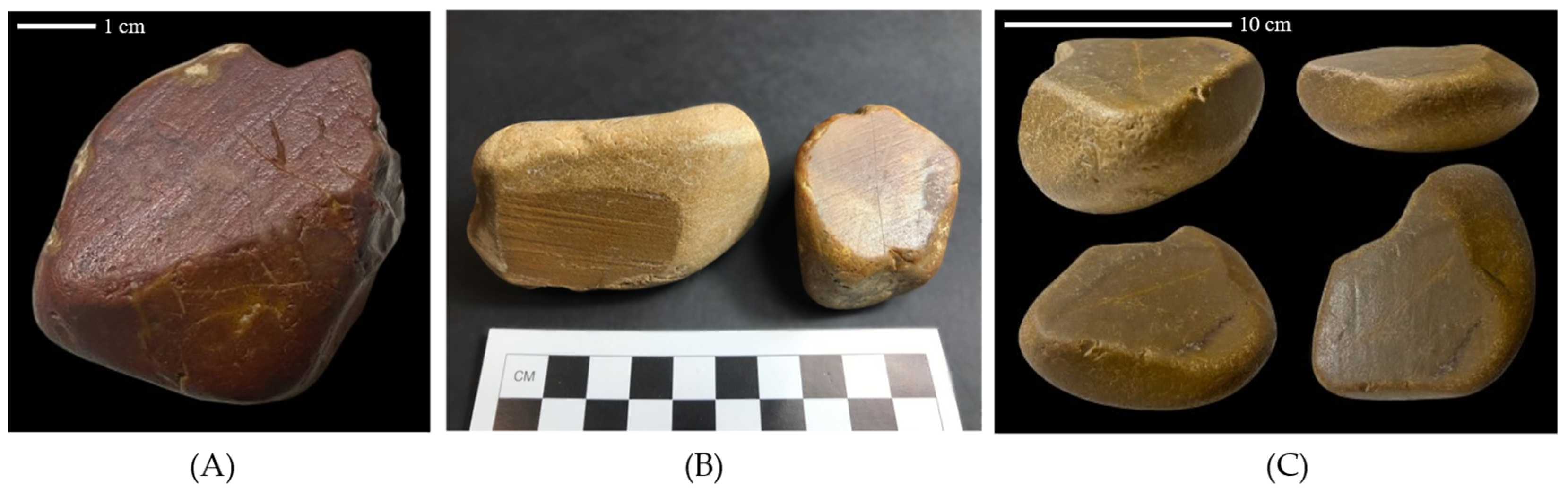
Figure 4.
Examples of glacially faceted chert clasts from the pre-loess terrace gravels collected from a gravel pit in the Rawhide Terrace, 32°28′29.20″ N, 90°37′11.56″ W, in Warren County, MS. (A,B) Found in the Mississippi Geological Survey collection and (C) in the Museum of the Mississippi Delta collection.

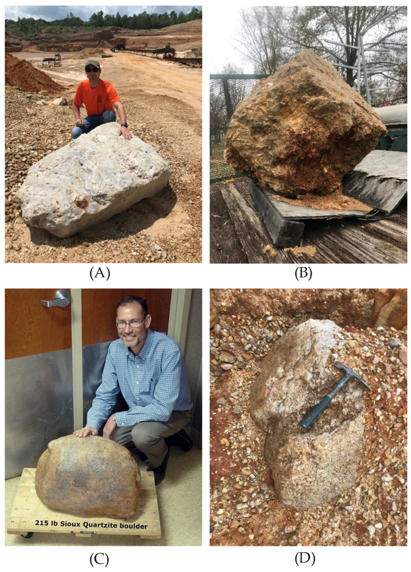
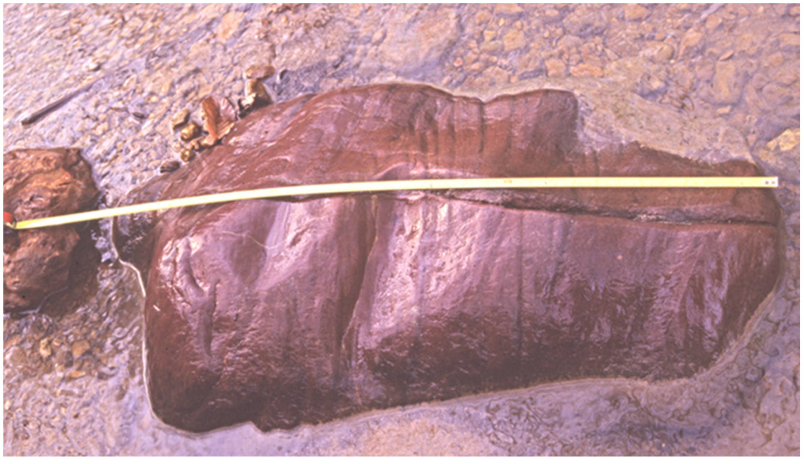
Figure 5.
Glacially ice-rafted Paleozoic chert boulders (A,B,D) and Precambrian Sioux Quartzite clasts (C) from the pre-loess terrace gravels (PLGs) collected from a gravel pit within the Rawhide Terrace, 32°28′29.20″ N, 90°37′11.56″ W, in Warren County, MS.

Figure 6.
A ~1-m-long boulder of Sioux Quartzite in a stream cutting the gravels of a pre-loess terrace deposit on the eastern side of Crowley’s Ridge, AR. Picture taken by Paul Sides on 5 May 2005 ([5]; used with permission from the Mississippi Geological Survey (MSGS)).
1.3. The Rawhide Terrace
One of these terraces is named the Rawhide Terrace (Figure 2). Detailed petrological studies have been conducted at the type locality in a gravel pit near Rawhide in eastern Warren County, MS (Figure 1B and Figure 7). MSGS test-hole drill logs and detailed mapping have delineated the Rawhide PLTD to have a consistent base ~220 feet above msl and a well-preserved alluvial plain terminus occupying an elevation of ~450 feet above msl (Figure 8; [6,7,13,15]). The Rawhide PLTD interval has been correlated across portions of west–central MS, including parts of west Hinds County, and caps much of Warren, Yazoo, and Claiborne Counties, and likely extends further north and south into unmapped areas of the Loess Bluffs region in MS (Figure 1) [6,7,13,15]. A particularly geologically significant pre-loess gravel (PLG) constituent in the Rawhide PLTD is a variety of detritally deposited clasts of siliceous volcanic rocks [6,7,13,15]. No igneous gravel constituents are known anywhere else in the geologic section exposed at the surface in the eastern Gulf Coastal Plain of MS prior to deposition of the Rawhide PLTD in the Pleistocene [6,7,13,15]. Understanding the igneous bedrock provenance and the timing of their contribution to the lower Mississippi Valley during the Pleistocene can provide insight into reconstructing the geological history of the ancestral Mississippi River and the stratigraphic significance of the Rawhide PLTD. This work combines geomorphological data and new petrographic and geochemical data in to describe the igneous suites of the PLGs, and to determine the extent of Independence “Kansan” glaciation into the midcontinent and the southeastern US.
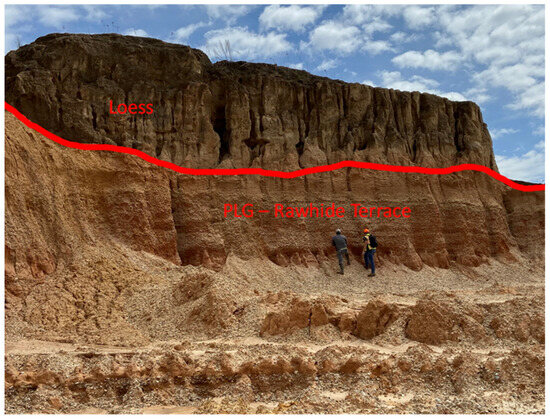
Figure 7.
Outcrop of loess overlying the PLTDs (Rawhide Terrace allounit) exposed in a highwall of a gravel pit, 32°28′29.20″ N, 90°37′11.56″ W, in Warren County, MS. Red line depicts the unconformable contact between the gravels of the pre-loess terrace and the overlying loess.
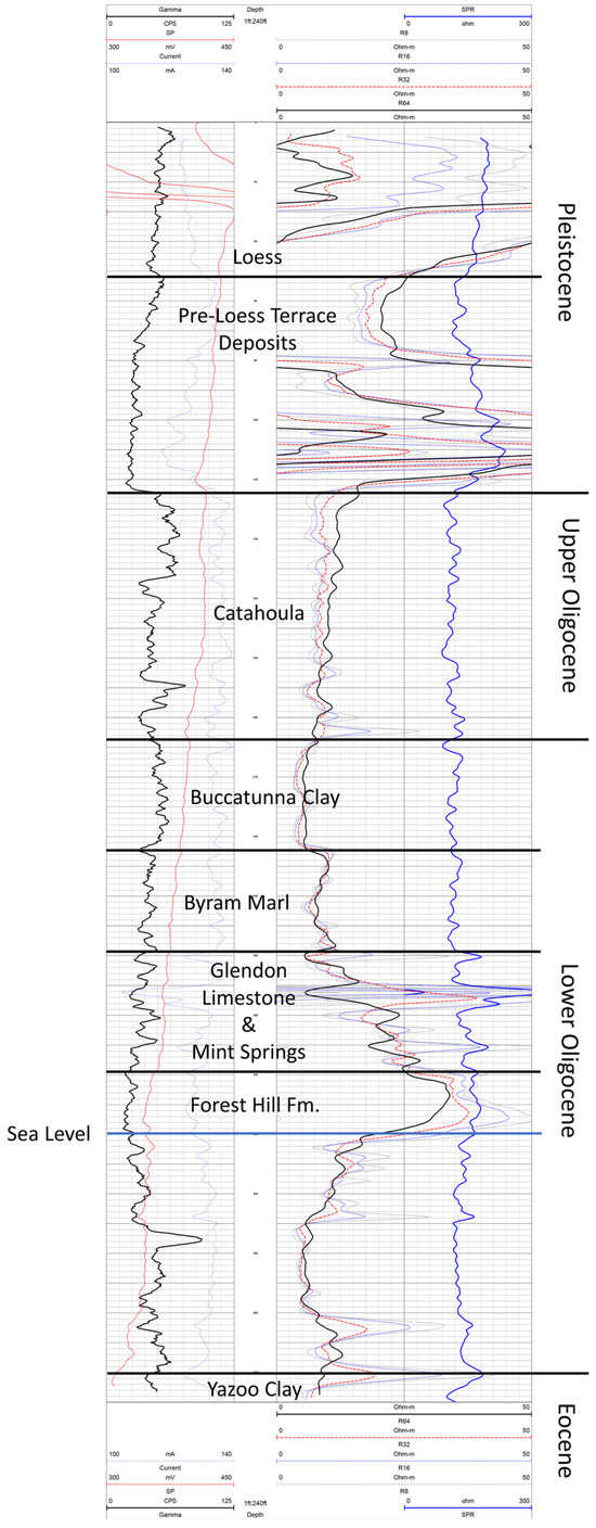
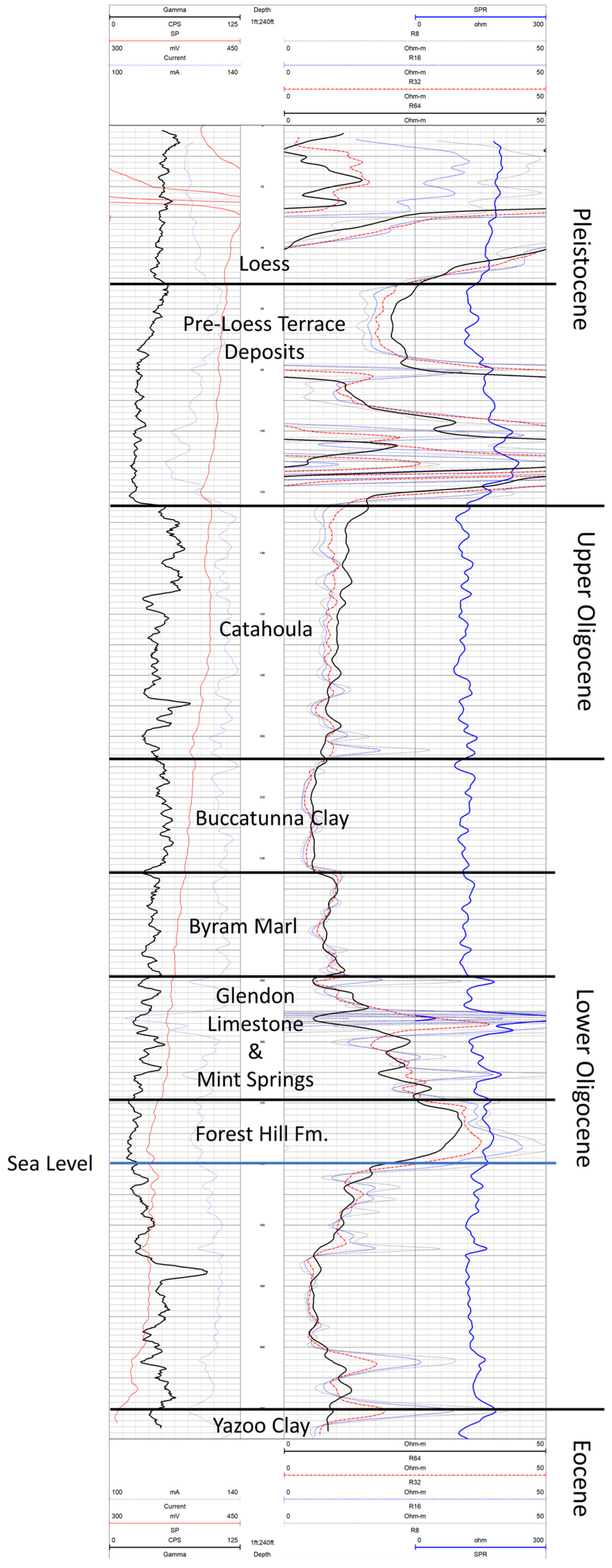
Figure 8.
MDEQ’s Office of Geology E-Log File# F-0053: MGS Vinzant #1. This State Survey test hole penetrated a full section of the Rawhide Terrace, PLTD allounit, underneath a thick blanket of loess and unconformably overlying the clays of the upper Oligocene Catahoula Formation in Warren County, MS. The test hole was drilled at a surface elevation of 340 ft above msl at 32°25′23.3″ N, −90°46′42.5″ W, and terminated in the top of the upper Eocene Yazoo Formation at a depth of 430 ft. Red and blue lines are resolution lines for the geophysical logging probe at various sized resolutions. More data on geophysical logging is available on MDEQ’s website via the link in data availability below.
1.4. Pre-Loess Gravels
Pre-loess terrace gravels (PLGs) can be found in the bluffs overlooking the Mississippi River Alluvial Plain and are largely masked by thick deposits of loess from the Late Pleistocene [6,22]. These mid-Pleistocene PLTDs parallel the Mississippi River Alluvial Plain from Desoto to Wilkinson County, MS, and are equivalent to the gravel deposits along the southern part of Crowley’s Ridge, AR [6,22]. PLGs are predominantly chert, derived from similar regions of the Paleozoic limestone bedrock drained by the Mississippi River’s present-day watershed [6,22]. PLGs also include gravel-to-boulder-sized clasts of trachytes, rhyolites, Sioux Quartzite, geodes from the Keokuk region, Missouri Lace Agate, large-cobble-size quartz clasts, a variety of sandstone and quartzite, and various types of jasper [6,22]. PLGs also occur re-deposited in stream terraces and alluvium from streams that dissect the Loess Bluffs region [15,22].
The PLTDs in MS are younger than the rest of the surrounding volcanic materials (Figure 1). The PLTDs correlate to the Independence “Kansan” glaciation during the Pleistocene (~2.5–1 Ma; [7,9]). The MIS 16–20/Independence “Kansan” glaciation refers to the extent of the penultimate glacial advance in North America [6,7,15,22,27,28,29]. The name comes from the fact that, in Kansas, the extent of glaciation is indicated by the extent of Sioux Quartzite erratics (Figure 6). Less than 1% Sioux Quartzite is modally significant, and is considered to be evidence of temporal and spatial proximity to a glacier [28,29]. Sioux Quartzite (Figure 5 and Figure 6) is also found within the MS PLG terraces [6,13,22,25,30]. It is found in larger quantities within the current Mississippi River Valley [6,13,22,25,30]. While Sioux Quartzite is found in both localities, the PLGs, and the current Mississippi River Valley, the presence of Sioux Quartzite does not account for the presence of volcanic materials in the PLTDs and cannot be used for correlation in the case of the PLGs [6,13,22,25,30].
The volcanic clasts within the PLGs are mentioned in geologic maps by Starnes and Leard [22], Starnes et al. [7], and Leard et al. [13,16,17,18]. Volcanic materials range from basaltic to rhyolitic compositions [6]. The terraces themselves sit at ~260–300 ft above msl, reach upwards of 100 ft in thickness, and have Sioux Quartzite gravels, depicting the current accepted glaciation [6,15,22]. While widespread Sioux Quartzite is expected, the regionally sourced volcanic clast constituents of the PLG provenance is equivocal [7]. Possible sources for the felsic volcanics include the St. Francois Mountains (SFMs), the Keweenawan Volcanic Province (KVP), and the Midcontinent Rift volcanics (MCR). Rocks erupted from the KVP and the MCR, which are in Iowa, northern Wisconsin, and Minnesota, near in situ Sioux Quartzite, show a bulk mafic composition [31,32,33,34], which does not directly correlate with the types of volcanics reported from the PLGs [15]. Archaeological studies have shown that pre-historic cultures widely exploited the igneous materials from the bedrock of Missouri’s SFMs, with rock being traded throughout the midcontinent and the southeast [15,22]. Much of the exotic igneous material from the SFMs can be found as artifacts on prehistoric archaeological sites in Mississippi [15,22]. The igneous materials could have also been traded from the original bedrock source; however, the geologic record shows that identical material is also available in the PLGs and was most likely exploited by ancient peoples [15,22]. Igneous rocks, suggested to come from the SFMs, while generally rare overall, are particularly common in the PLGs [15]. Observed igneous suites include rhyolite, trachyte, welded tuff, and the significantly less common diabase [15]. Igneous rocks from other regions in the midcontinent, such as Minnesota, Wisconsin, and Canada, can be seen in the modern Mississippi River’s alluvium [5,7,13,15,22]; these northern suites of igneous materials (i.e., Keweenawan Volcanics, Midcontinental Rift, and Canadian granites) are also absent from the older PLGs in the adjacent bluffs [5,7,13,15,22].
Moreover, du Bray and others [8] described the SFMs as being dominated by ~1480–1450 Ma volcanic and plutonic magmatism, with minor younger bimodal contributions (~1340–1270 Ma). The chemistry and petrography of the SFMs is detailed and is used here as a comparison for the data from the pre-loess gravels of Mississippi due to the spatial proximity and temporal correlation to currently reported glacial margins, better tying these volcanic clasts to the SFM. Doing so greatly aids in the understanding of the evolution of the Mississippi River Valley during the glacial period of the Pleistocene (~2.5–1.0 Ma) [5,6,7,13,15,25]. Hand sample analysis by previous authors hypothesized the volcanic clasts in the PLGs to be from the SFMs of Missouri via archaeological study [6,15,22,30]; however no geochemical or petrologic supporting data have directly correlated the gravels to the SFMs or to the Keweenawan or Midcontinent Rift systems.
2. Methods
Representative samples (~5–15 kg of rock) were collected from a variety of locations within the PLGs along the Mississippi River over the last 20 years by the Mississippi Department of Environmental Quality’s (MDEQ) Surface Geology Division. Large sample sizes were taken to ensure an average chemical composition of the rock types being analyzed. In some cases, for this project, representative samples were smaller (~2–3 kg; fist-sized pieces of sample) due to the rarity of occurrence within the PLGs (Figure 1B). This was due to the limited availability of high-quality (not completely weathered to clay) volcanic samples within the PLGs and allowed MDEQ to keep some of the samples for sample filing, as well as for use as part of the geochemical analysis for this study. Samples were then trimmed of weathering rinds using a rock saw and crushed using a BICO Inc. Chipmunk jaw crusher. The jaws of the crusher were cleaned and sanitized prior to each sample run to ensure sample quality. After bulk crushing, the samples were milled to a fine powder or rock pulp via a puck mill. The pulps were prepared so that 95% of the pulp passed through a 200-mesh sieve (74 µm) using a puck mill, which ensured the proper fusion of the sample during the analysis and proper quality control [35]. The resulting rock pulps were mechanically split and reduced to ~10 g vials and packaged. Bulk geochemical data were collected at Activation Laboratories (ActLabs) in Ancaster, Ontario, using their Code 4-Litho-Research methods, as outlined in Hoffman and Dunn and in the ActLabs schedule of services [35,36]. The fusion technique ActLabs employs is a lithium metaborate/tetraborate fusion for analysis with Fusion ICP/MS [35,36]. Fusion is performed by a robot, which provides rapid fusion with a high quality [35,36]. The resulting molten bead is rapidly digested in a weak nitric acid solution [35,36]. The fusion ensures that the entire sample is dissolved [35,36]. This is the simplest method to analyze major oxides, rare earth elements (REEs), and trace elements, as well as digesting silicates into a solution for geochemical analysis [35,36]. Returned data reports include majors, trace, and REEs, as outlined above [35,36,37]. Standard calibration occurred every 8 samples using a series of standards, including NIST 694 [36]. Data were normalized using the CIPW Norm calculator from Hollocher [38] for ease of use in future works (after [39]; Tables S1 and S2). After normalizing the data, a series of graphical representations in the form of total alkali–silica (TAS) diagrams and spider diagrams were created. Raw ICP-MS and quality control data are also included in the Supplemental Files located at the end of this article. Thin sections were also made to aid in describing the PLG samples. Petrographic descriptions were completed for each thin section by utilizing a polarizing light microscope set up for petrographic analysis. Photomicrographs and petrographic descriptions are included in the Supplementary Materials (Figures S1–S7).
3. Results
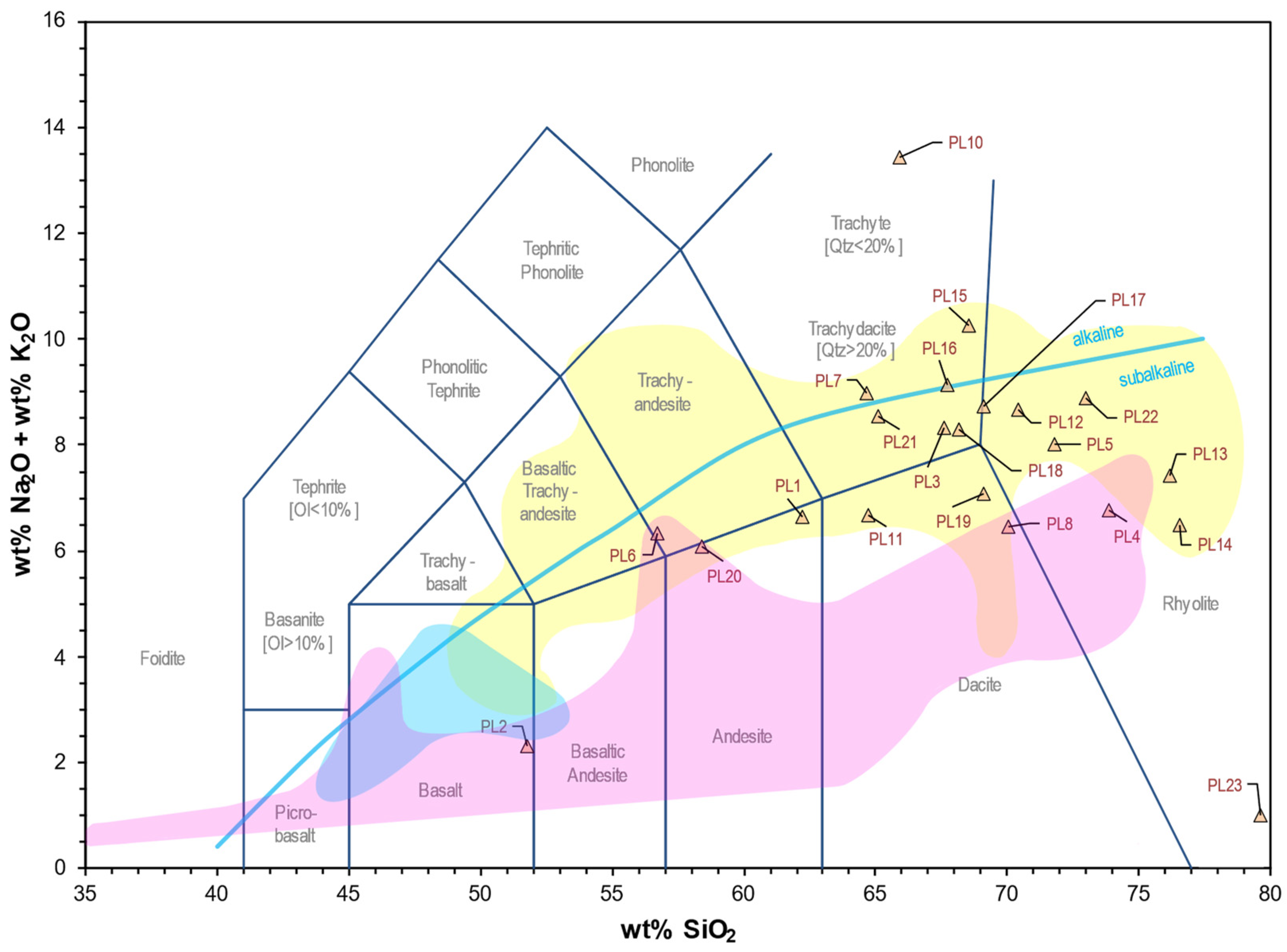
The PLG samples exhibit the full range of compositions within the sub-alkaline field of the TAS (Figure 9), with some samples reaching into the alkaline field (PL10; Figure 9). Major oxides indicate bulk chemical suites of mainly intermediate to felsic compositions, with one instance of basalt (PL2; Table 1). Data also show a SiO2 content ranging from 45.69 wt.% on the low end (PL2; basalt) to 75.18 wt.% on the higher end (PL14; rhyolite) (Table 1; Figure 9). Na2O abundances range from 0.1 wt.% to 4.1 wt.%, and K2O abundances range from 0.6 wt.% to 12.8 wt.%. The TAS plots for the PLG samples also indicate a bimodal distribution favoring rhyolite and sub-alkaline intermediate suites. Rhyolitic samples are dominated by plagioclase, potassium feldspar species, and quartz phenocrysts, where the trachytic samples have modal amounts of plagioclase and potassium feldspar species (~1–3 mm in diameter) phenocrysts, while PL2 has modal clinopyroxene phenocrysts, indicating a basaltic composition.
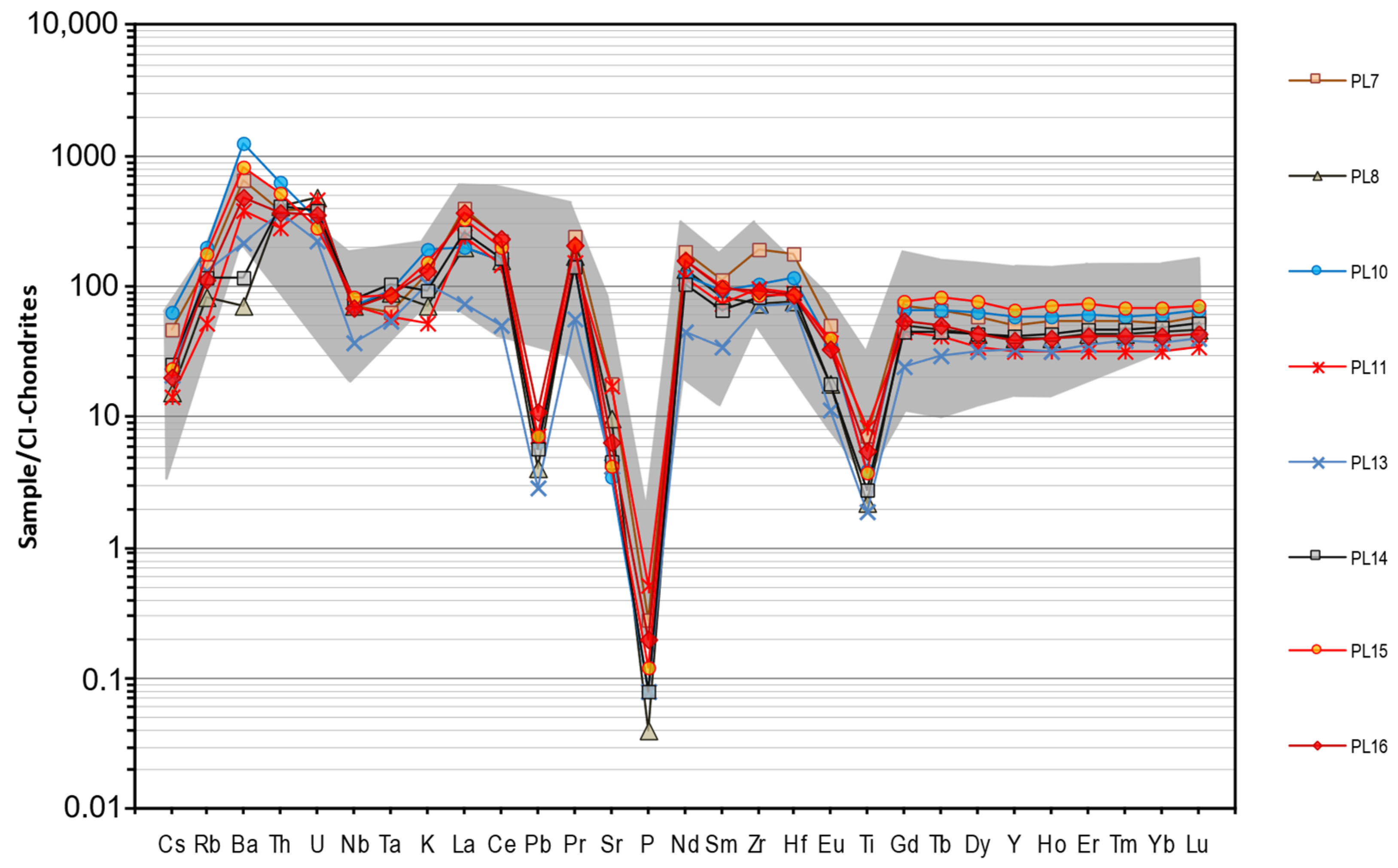
The trace element and REE concentrations within the PLGs vary. The PLG samples show elevated Zr, low Sc, Be, Cu, Nb, Ni, Sr, and Th (Table 2). They also show an increased abundance of Ba, Hf, La, Nb, Rb, Th, U, Y, and Zr with an increasing silica content when compared to N-MORB, while Co, Cr, Cu, Ni, Sc, Sr, V, and Zn decrease with an increased silica content compared to N-MORB, with some analytes even falling below the detection limit of the ICP-MS (Table 2; Figure 10).
Photomicrographs taken at a power of 4× and 10× show congruence with the rock species identified via the geochemical analysis (Figures S1–S7). Samples are fine-to-medium-grained volcanic rocks, and the phenocrysts in the PLG samples are dominated by feldspar species with minor quartz phenocrysts in more felsic samples. The plagioclase (pl) phenocrysts show albite twinning, and the high-K calc–alkaline samples show exsolution microcline (mc) lamellae twinning in feldspar grains (Figures S1–S7; mineral abbreviations from [40]). In addition, there are minor amounts of higher-temperature mineral phenocrysts such as biotite (bi), hornblende (hbl), and clinopyroxene (~1%; e.g., Figure S1B; cpx; mineral abbreviations from [40]). There is also a sample with modal nepheline, indicating silica depletion (e.g., Figure S2M).

Table 1.
Normalized major oxide analyses for the PLGs in weight percent (wt.%). Samples normalized using the CIPW Norm calculator from Hollocher [38] (after [39]). Samples are from the yellow boxed region of the area shaded in Figure 1B.
Table 1.
Normalized major oxide analyses for the PLGs in weight percent (wt.%). Samples normalized using the CIPW Norm calculator from Hollocher [38] (after [39]). Samples are from the yellow boxed region of the area shaded in Figure 1B.
| Sample | SiO2 | TiO2 | Al2O3 | Fe2O3 | FeO | MnO | MgO | CaO | Na2O | K2O | P2O5 |
|---|---|---|---|---|---|---|---|---|---|---|---|
| PL1 | 63.0 | 0.5 | 13.2 | 4.6 | 9.7 | 0.2 | 0.7 | 2.4 | 4.1 | 2.7 | 0.17 |
| PL2 | 45.7 | 1.4 | 14.6 | 6.5 | 13.6 | 0.2 | 6.3 | 8.9 | 2.0 | 0.6 | 0.15 |
| PL3 | 66.4 | 0.2 | 11.8 | 3.6 | 7.5 | 0.1 | 0.2 | 0.3 | 2.5 | 5.7 | 0.05 |
| PL4 | 72.7 | 0.2 | 10.7 | 2.6 | 5.4 | 0.1 | 0.0 | 0.1 | 3.7 | 3.0 | 0.03 |
| PL5 | 70.8 | 0.2 | 11.1 | 2.7 | 5.7 | 0.1 | 0.1 | 0.1 | 0.3 | 7.7 | 0.02 |
| PL6 | 57.5 | 0.6 | 12.4 | 7.2 | 15.2 | 0.2 | 0.6 | 1.1 | 3.8 | 2.7 | 0.28 |
| PL7 | 64.7 | 0.5 | 12.9 | 4.0 | 8.4 | 0.1 | 0.2 | 0.1 | 0.5 | 8.5 | 0.07 |
| PL8 | 70.7 | 0.2 | 10.0 | 4.2 | 8.7 | 0.1 | 0.1 | 0.4 | 1.8 | 4.8 | 0.01 |
| PL9 | 81.4 | 0.0 | 0.5 | 6.6 | 13.8 | 0.1 | 0.0 | 0.1 | 0.1 | 0.1 | 0.00 |
| PL10 | 64.7 | 0.3 | 18.3 | 0.5 | 1.0 | 0.0 | 0.1 | 0.1 | 0.4 | 12.8 | 0.02 |
| PL11 | 64.1 | 0.6 | 14.5 | 3.8 | 8.0 | 0.1 | 0.5 | 0.7 | 3.1 | 3.5 | 0.13 |
| PL12 | 68.8 | 0.3 | 15.2 | 1.5 | 3.1 | 0.1 | 0.1 | 0.1 | 0.9 | 7.6 | 0.03 |
| PL13 | 73.9 | 0.1 | 11.7 | 1.3 | 2.6 | 0.0 | 0.1 | 0.1 | 0.3 | 6.9 | 0.02 |
| PL14 | 75.2 | 0.2 | 9.8 | 2.1 | 4.4 | 0.1 | 0.1 | 0.1 | 0.2 | 6.2 | 0.02 |
| PL15 | 69.2 | 0.3 | 13.8 | 2.3 | 4.9 | 0.0 | 0.0 | 0.0 | 0.2 | 10.2 | 0.03 |
| PL16 | 67.2 | 0.4 | 12.1 | 3.3 | 6.9 | 0.1 | 0.1 | 0.1 | 0.4 | 8.7 | 0.05 |
| PL17 | 68.2 | 0.2 | 11.9 | 3.1 | 6.5 | 0.1 | 0.0 | 0.1 | 1.1 | 7.5 | 0.02 |
| PL18 | 67.6 | 0.4 | 12.9 | 3.1 | 6.6 | 0.1 | 0.1 | 0.1 | 1.6 | 6.6 | 0.07 |
| PL19 | 69.4 | 0.2 | 11.3 | 4.0 | 8.3 | 0.1 | 0.0 | 0.1 | 3.8 | 3.3 | 0.02 |
| PL20 | 57.7 | 0.9 | 13.2 | 5.6 | 11.8 | 0.2 | 1.2 | 2.0 | 2.9 | 3.1 | 0.25 |
| PL21 | 64.9 | 0.8 | 13.9 | 3.6 | 7.5 | 0.1 | 0.1 | 0.2 | 2.2 | 6.4 | 0.21 |
| PL22 | 71.6 | 0.3 | 11.8 | 1.8 | 3.7 | 0.0 | 0.1 | 0.1 | 0.5 | 8.2 | 0.02 |
| PL23 | 74.6 | 0.6 | 10.6 | 2.2 | 4.6 | 0.0 | 0.1 | 0.1 | 0.1 | 0.8 | 0.05 |

Figure 9.
Total alkali–silica plot of the data from the samples of the PLGs of Mississippi, showing a high silica suite of volcanics with few mafics. PL23 are fragments of a rhyolitic sample that were severely degraded due to weathering.
Figure 9.
Total alkali–silica plot of the data from the samples of the PLGs of Mississippi, showing a high silica suite of volcanics with few mafics. PL23 are fragments of a rhyolitic sample that were severely degraded due to weathering.
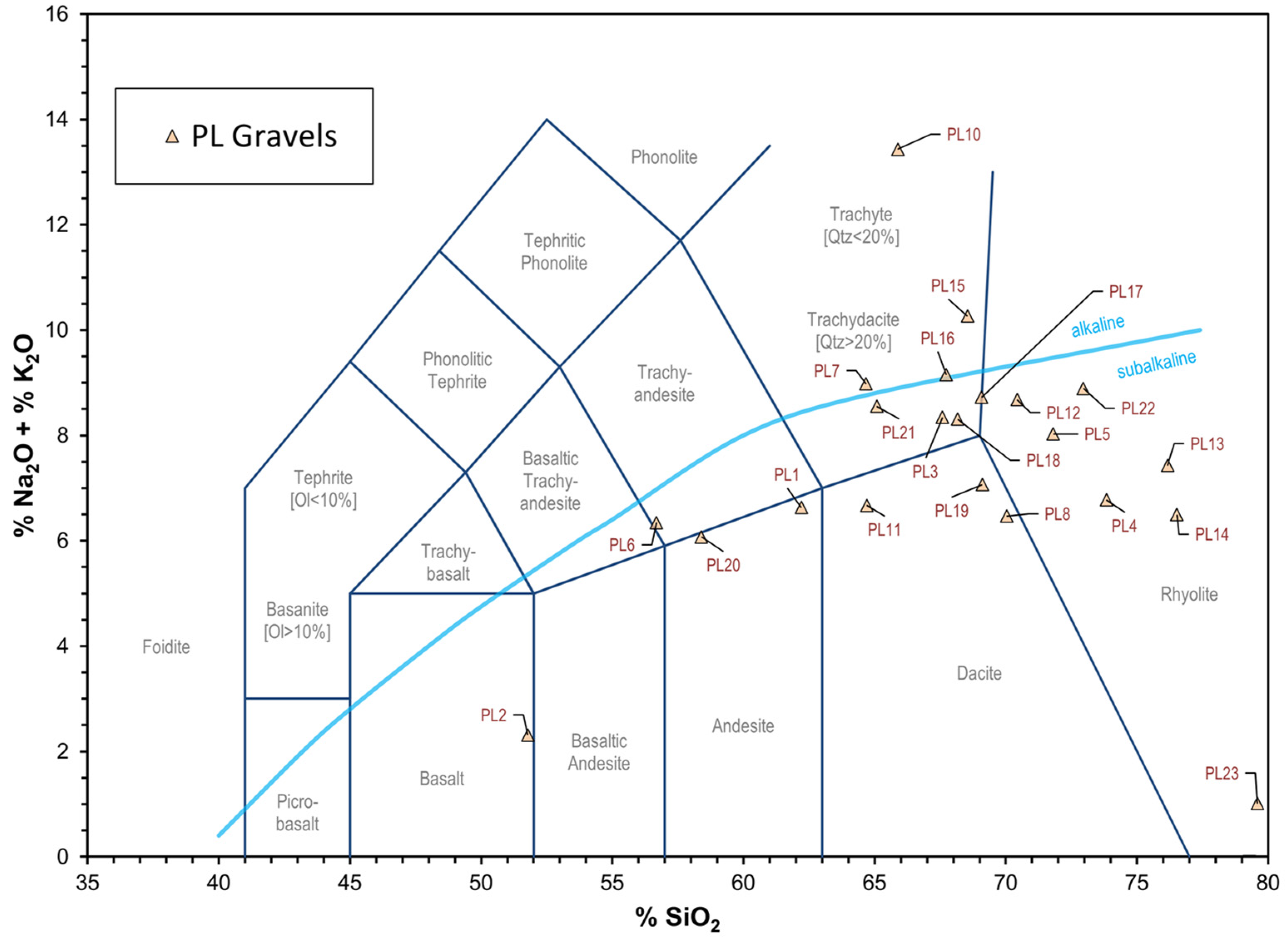
Table 2.
Trace and REE data compared to silica. REEs are separated by lines.
Table 2.
Trace and REE data compared to silica. REEs are separated by lines.
| Analyte | Unit | PL1 | PL2 | PL3 | PL4 | PL5 | PL6 | PL7 | PL8 | PL9 | PL10 | PL11 | PL12 | PL13 | PL14 | PL15 | PL16 | PL17 | PL18 | PL19 | PL20 | PL21 | PL22 | PL23 |
| SiO2 | wt% | 63.0 | 45.7 | 66.4 | 72.7 | 70.8 | 57.5 | 64.7 | 70.7 | 81.4 | 64.7 | 64.1 | 68.8 | 73.9 | 75.2 | 69.2 | 67.2 | 68.2 | 67.6 | 69.4 | 57.7 | 64.9 | 71.6 | 74.6 |
| Sc | ppm | 2 | 29 | <1 | <1 | 4 | 10 | <1 | <1 | 3 | <1 | <1 | <1 | 4 | 5 | 4 | <1 | <1 | <1 | <1 | 12 | <1 | <1 | <1 |
| Be | ppm | 3 | 1 | 2 | 2 | 1 | 3 | 2 | 2 | <1 | 1 | 2 | 2 | <1 | 1 | <1 | 1 | <1 | 2 | 1 | 2 | 2 | 1 | 2 |
| V | ppm | 36 | 253 | 10 | 7 | 10 | 36 | 35 | 10 | 10 | <5 | 26 | 8 | <5 | 6 | 9 | 15 | 12 | 19 | 7 | 62 | 42 | 12 | 52 |
| Cr | ppm | 50 | 140 | 30 | 30 | 30 | 70 | 40 | 40 | 50 | <20 | 100 | 40 | <20 | 20 | 30 | 40 | 30 | 40 | 40 | 70 | 120 | 40 | 50 |
| Co | ppm | 14 | 61 | 8 | 4 | 4 | 12 | 8 | 5 | 6 | 1 | 12 | 3 | 2 | 3 | 3 | 6 | 5 | 12 | 5 | 35 | 7 | 4 | 5 |
| Ni | ppm | 40 | 160 | 40 | 30 | 20 | 50 | 20 | 40 | 40 | <20 | 40 | 30 | 20 | <20 | <20 | 20 | 20 | 30 | 30 | 60 | <20 | <20 | 50 |
| Cu | ppm | 250 | 170 | 90 | 70 | 70 | 150 | 90 | 120 | 190 | 50 | 110 | 80 | 40 | 80 | 90 | 130 | 180 | 90 | 110 | 200 | 110 | 90 | 120 |
| Zn | ppm | 70 | 90 | 40 | 40 | 40 | 100 | 50 | 60 | <30 | 40 | 100 | 220 | <30 | 70 | <30 | 60 | 40 | <30 | <30 | 110 | <30 | 50 | 70 |
| Ga | ppm | 18 | 20 | 23 | 19 | 19 | 20 | 25 | 18 | 2 | 13 | 22 | 24 | 17 | 17 | 12 | 18 | 14 | 20 | 18 | 19 | 17 | 17 | 23 |
| Ge | ppm | 2.5 | 1.6 | 1.7 | 1.9 | 1.9 | 2.4 | 1.7 | 1.8 | 3 | 1.1 | 1.6 | 1.8 | 1.8 | 1.7 | 2.2 | 1.7 | 1.4 | 1 | 1.4 | 1.6 | 1.3 | 1.2 | 1.2 |
| As | ppm | 18 | <5 | 6 | <5 | 5 | 14 | 13 | 19 | <5 | 34 | 9 | 7 | <5 | 102 | 15 | 71 | 16 | 13 | 7 | 13 | 7 | <5 | 23 |
| Rb | ppm | 83 | 29 | 219 | 105 | 353 | 90 | 324 | 191 | 5 | 467 | 122 | 276 | 303 | 270 | 409 | 256 | 261 | 211 | 104 | 136 | 252 | 272 | 36 |
| Sr | ppm | 231 | 259 | 53 | 27 | 25 | 185 | 128 | 71 | 11 | 25 | 126 | 46 | 31 | 33 | 31 | 46 | 24 | 36 | 30 | 268 | 225 | 15 | 15 |
| Y | ppm | 45.5 | 19.7 | 70.1 | 71.1 | 65.2 | 57.2 | 80.4 | 62.4 | 2.3 | 91.4 | 50.7 | 135 | 52 | 65.6 | 103 | 60.8 | 43.6 | 85.8 | 72.9 | 40.4 | 61.7 | 67.4 | 110 |
| Zr | ppm | 282 | 103 | 342 | 366 | 402 | 336 | 725 | 281 | 13 | 394 | 368 | 698 | 274 | 321 | 329 | 352 | 332 | 390 | 517 | 159 | 783 | 856 | 802 |
| Nb | ppm | 17 | 23.8 | 24.3 | 15.6 | 17.3 | 24.3 | 16.9 | 17.1 | 9.4 | 16.8 | 17.1 | 26.3 | 9 | 18.9 | 20 | 16.6 | 12.8 | 17.9 | 16.2 | 19 | 25.2 | 18.4 | 42.9 |
| Ba | ppm | 644 | 214 | 279 | 80 | 453 | 653 | 1587 | 172 | 38 | 2968 | 917 | 920 | 521 | 279 | 1952 | 1145 | 1392 | 1084 | 267 | 808 | 1368 | 1236 | 208 |
| La | ppm | 37.5 | 16.4 | 73.2 | 52.8 | 32.9 | 51.3 | 94.7 | 47.9 | 2.82 | 47.6 | 57.6 | 41.4 | 17.8 | 62.2 | 76.9 | 86.5 | 34.1 | 130 | 47.4 | 33.6 | 329 | 17.5 | 42.2 |
| Ce | ppm | 78.3 | 34.2 | 138 | 104 | 75.3 | 112 | 135 | 96.1 | 4.97 | 98.6 | 88.5 | 56.4 | 31 | 99.7 | 123 | 140 | 75.8 | 107 | 120 | 68.5 | 265 | 26.1 | 116 |
| Pr | ppm | 10.2 | 4.4 | 19.3 | 14.4 | 8.06 | 14.5 | 22.2 | 15.6 | 0.71 | 13.8 | 14 | 9.12 | 5.19 | 13.3 | 18.9 | 19.4 | 9.71 | 34.5 | 12.9 | 9.09 | 38.1 | 4.98 | 12.7 |
| Nd | ppm | 41.3 | 19.1 | 70.6 | 55.5 | 30.6 | 60 | 84.9 | 61.1 | 2.51 | 54.5 | 53.8 | 34.5 | 20.4 | 47.5 | 72.2 | 71.6 | 37 | 129 | 49.4 | 37.4 | 124 | 20.1 | 53.6 |
| Sm | ppm | 8.87 | 4.44 | 14.1 | 11.2 | 7.15 | 12.8 | 16.8 | 12.4 | 0.55 | 13.5 | 10.9 | 7.5 | 5.09 | 9.71 | 15.1 | 14.1 | 7.76 | 25.6 | 10.8 | 8.45 | 22.1 | 4.74 | 14.5 |
| Eu | ppm | 1.59 | 1.31 | 1.19 | 0.944 | 0.668 | 1.99 | 2.82 | 1.02 | 0.131 | 2.04 | 2.11 | 1.21 | 0.639 | 1 | 2.29 | 1.89 | 1.18 | 4.35 | 0.958 | 2.22 | 3.99 | 0.95 | 2.76 |
| Gd | ppm | 7.81 | 4.05 | 11.1 | 9.38 | 6.76 | 11 | 14.3 | 9.87 | 0.44 | 13.1 | 9.04 | 7.19 | 4.87 | 8.92 | 15.5 | 10.7 | 5.97 | 17.7 | 9.09 | 7.23 | 16.4 | 5.15 | 14.8 |
| Tb | ppm | 1.31 | 0.68 | 1.93 | 1.79 | 1.46 | 1.77 | 2.39 | 1.68 | 0.07 | 2.34 | 1.48 | 2.16 | 1.05 | 1.61 | 2.94 | 1.79 | 1.21 | 2.79 | 1.75 | 1.2 | 2.43 | 1.25 | 2.94 |
| Dy | ppm | 7.84 | 3.94 | 12.3 | 11.3 | 10.5 | 10.6 | 14.6 | 10.6 | 0.39 | 15.3 | 8.47 | 19 | 7.86 | 10.8 | 18.7 | 10.8 | 7.4 | 16.4 | 11.9 | 7.37 | 13.5 | 9.82 | 19.2 |
| Ho | ppm | 1.64 | 0.78 | 2.59 | 2.56 | 2.41 | 2.14 | 2.95 | 2.19 | 0.09 | 3.15 | 1.72 | 4.8 | 1.76 | 2.33 | 3.84 | 2.19 | 1.59 | 3.17 | 2.49 | 1.47 | 2.42 | 2.32 | 4.22 |
| Er | ppm | 4.79 | 2.15 | 8.1 | 8.38 | 7.72 | 6.15 | 8.83 | 6.91 | 0.22 | 9.66 | 5.17 | 15.5 | 5.64 | 7.4 | 11.6 | 6.54 | 4.83 | 9.54 | 7.89 | 4.36 | 6.62 | 8.22 | 13.1 |
| Tm | ppm | 0.767 | 0.326 | 1.27 | 1.32 | 1.24 | 0.908 | 1.32 | 1.05 | 0.039 | 1.47 | 0.79 | 2.44 | 0.94 | 1.16 | 1.71 | 1.02 | 0.816 | 1.49 | 1.26 | 0.665 | 1.01 | 1.43 | 2.05 |
| Yb | ppm | 4.82 | 2.04 | 8.78 | 9.7 | 8.43 | 5.76 | 8.59 | 7.22 | 0.33 | 9.66 | 5.19 | 17.5 | 6.08 | 7.67 | 11 | 6.68 | 5.25 | 10.2 | 8.92 | 4.51 | 6.54 | 10.5 | 14.6 |
| Lu | ppm | 0.778 | 0.321 | 1.42 | 1.61 | 1.45 | 0.999 | 1.42 | 1.16 | 0.05 | 1.63 | 0.855 | 2.75 | 1 | 1.27 | 1.74 | 1.08 | 0.91 | 1.58 | 1.53 | 0.765 | 1.1 | 1.87 | 2.36 |
| Hf | ppm | 7.2 | 3 | 9.8 | 10.4 | 10.4 | 8.6 | 18.5 | 8 | 0.2 | 11.8 | 9.2 | 20.9 | 7.6 | 9.2 | 8.8 | 8.8 | 9.2 | 10.7 | 12.6 | 4.3 | 20.3 | 22.8 | 22.2 |
| Ta | ppm | 0.67 | 0.92 | 1.76 | 1.18 | 1.24 | 0.67 | 0.87 | 1.23 | 0.06 | 1.27 | 0.79 | 2.12 | 0.75 | 1.4 | 1.17 | 1.19 | 0.71 | 1.11 | 1.01 | 0.57 | 1.36 | 1.7 | 3.64 |
| W | ppm | 4.6 | 0.7 | 2 | <0.5 | 3.8 | 2.4 | 5.8 | 2 | <0.5 | 4.9 | 1.2 | 3.2 | 0.6 | 1.7 | 4.1 | 2.5 | 2.4 | 1.8 | 9 | 13.7 | 12.7 | 9.5 | 2.7 |
| Tl | ppm | 0.23 | 0.13 | 0.71 | 0.26 | 1.12 | 0.3 | 1.03 | 0.66 | <0.05 | 1.87 | 0.59 | 0.88 | 1.07 | 0.88 | 1.79 | 0.83 | 1.1 | 0.52 | 0.31 | 0.42 | 1.21 | 1.09 | 0.16 |
| Pb | ppm | 14 | <5 | 13 | 19 | 43 | 22 | 17 | 10 | <5 | 16 | 18 | 162 | 7 | 14 | 18 | 27 | 26 | 11 | 13 | 18 | 143 | 12 | 31 |
| Th | ppm | 5.89 | 1.86 | 18.4 | 16.6 | 14.7 | 6.48 | 11 | 11.9 | 0.36 | 18 | 8.11 | 26.1 | 10.8 | 12 | 15 | 10.6 | 10.4 | 13.5 | 13.8 | 5.36 | 15.9 | 21.4 | 25.9 |
| U | ppm | 2.3 | 0.35 | 4.77 | 3.94 | 3.85 | 2.21 | 2.88 | 3.59 | 0.49 | 2.44 | 3.43 | 8.42 | 1.64 | 2.87 | 2.04 | 2.57 | 2.53 | 3.78 | 4.49 | 2.07 | 5.21 | 8.07 | 5.16 |
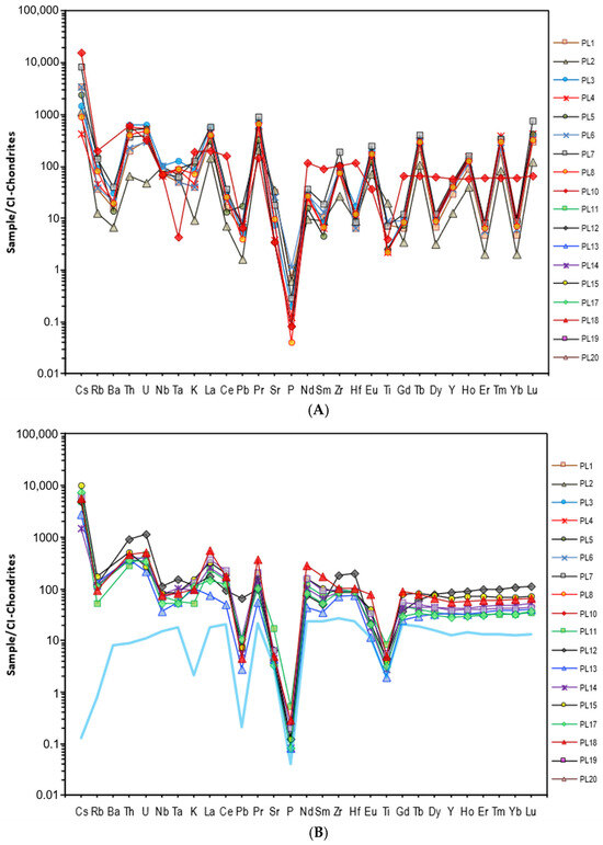
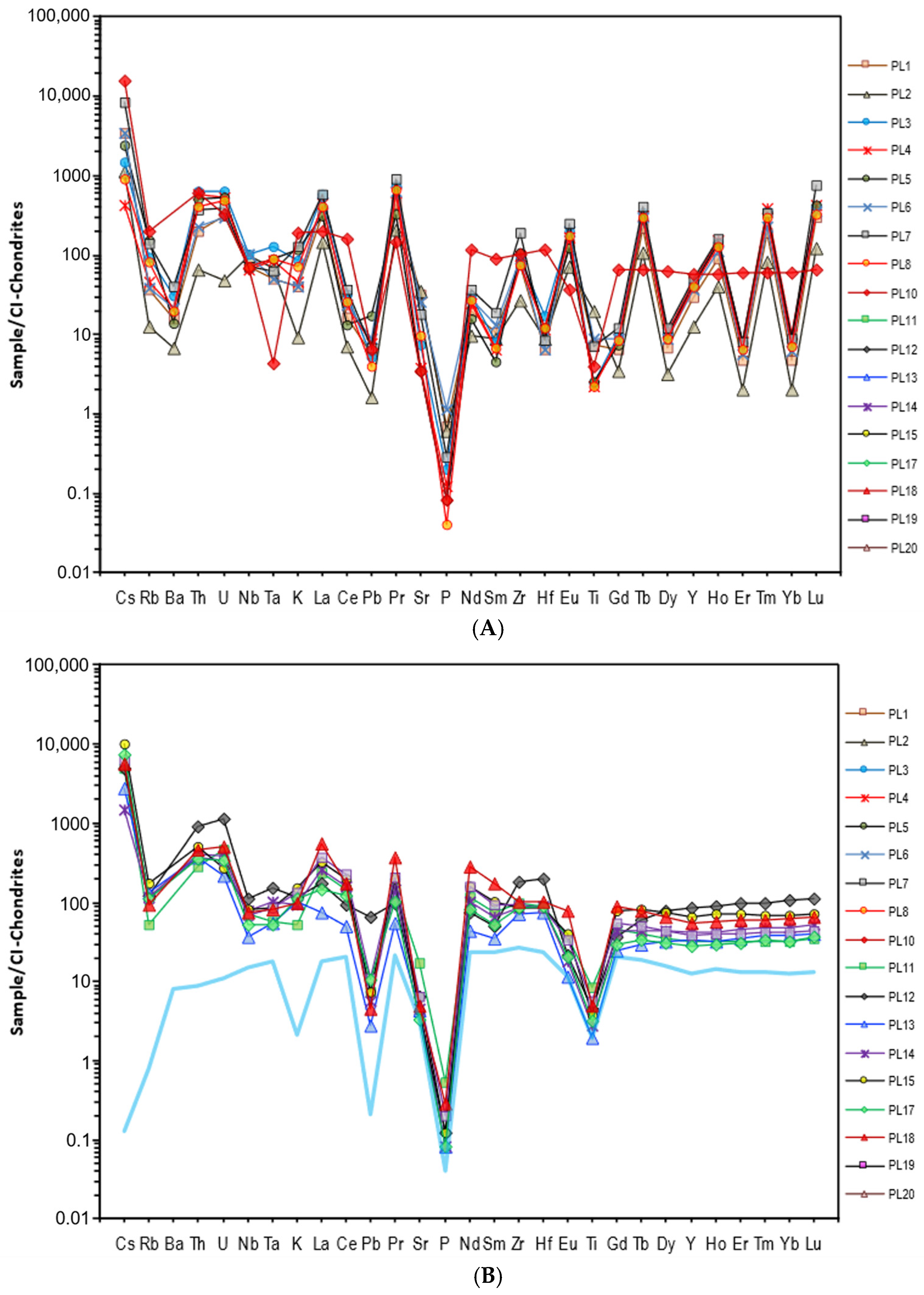
Figure 10.
Trace and REE spider diagram for select PLG samples chosen to represent all of the major rock types present, normalized using Cl-Chondrites [41]. (A) PL2 is basalt, PL1 is andesite, and PL3-PL8 and PL10 range from trachyandesite to rhyolite; (B) PL11-PL20 range from the felsic suites of both alkaline and sub-alkaline (defined in the TAS in Figure 9). The light-blue line is the average N-MORB [42].
4. Discussion
4.1. St. Francois Mountains
In the SFMs (~1480–1450 Ma), there is a bimodal distribution of volcanic species ranging from basalts to trachytes and rhyolites (Figure 11; [8,43]). The samples from the PLG were able to capture the whole spectrum of volcanic materials seen within the SFMs. Most of the samples are felsic end-member volcanics such as rhyolite, dacite, trachyte, and trachydacite (Figure 11). The mafic-to-intermediate end-member samples range from basalt to andesite in composition (Figure 11). Data from the SFMs (e.g., [39,40,41,42,43,44,45,46,47,48,49,50,51]) have been recreated from the USGS open-source data sets available [43] (Figure 11). Data shown here (Figure 9 and Figure 11) are consistent with detailed published data from the SFMs ([8,39,40,41,42,43,44,45,46,47,48,49,50,51]).

Figure 11.
Total alkali–silica plot of the PLG data from this study overlaying published data from the volcanic samples of the SFMs (yellow field; n = 472 volcanic samples [8,39,40,41,42,43,44,45,46,47,48,49]), KVP (blue field; n = 30 volcanic samples [28,51]), and MCR (pink field; n = 16 volcanic samples [30,52]).
The petrography of the SFM samples, described by du Bray et al. [8], have phenocryst assemblages of rhyolite tuffs and lavas that are dominated by major amounts of plagioclase, alkali feldspar, and quartz, while the mafic phenocrysts are rare and are replaced by iron and titanium oxide minerals. Phenocryst assemblages of basaltic to trachyte composition rocks are dominated by clinopyroxene, hornblende, and minor biotite, and often contain fewer phenocrysts than their felsic counterparts [39,40,41,42,43,44,45,46,47,48,49,50]. The sizes and phenotypes within the PLGs (Figures S1–S7) are consistent with the observations made by du Bray and others [8], and provide additional evidence for the case that the SFMs contributed material to the PLGs.
Observed geochemical trends are similar in both the PLG and SFM samples (Figure 10, Figure 11 and Figure 12). The SFM samples [8,44,45,46,47,48,49,50,51,52,53,54,55,56] have a bimodal spread of chemistries, from basaltic to rhyolitic, with dominant groupings within the rhyolite chemistries and in the basaltic to basaltic trachyandesite suites (Figure 11). The SFMs are dominated by rhyolitic suites with ~72–78 wt.% SiO2, but this includes rhyolites with as little silica as ~69 wt.% [39,40,41,42,43,44,45,46,47,48,49,50]. In the mafic SFM suites, there are silica abundances as low as ~49 wt.% and as high as ~57 wt.% [39,40,41,42,43,44,45,46,47,48,49,50]. The trachyandesites to trachytes have ~60–68 wt.% silica [8]. Most of the rock in the SFMs are sub-alkaline, with a few occurrences of alkaline suites like trachyte and trachyandesite [39,40,41,42,43,44,45,46,47,48,49,50]. When compared with the PLG’s chemistries (Figure 11), the distribution of the samples is similar, and we see a broadly bimodal spread favoring rhyolite, but we seem to only be seeing the high-silica–alkalic and high-silica–sub-alkalic suites, and a single basaltic sample. The proposed reason for this is basalt’s rarity within the SFMs (Figure 3), where it only occurs in the southern portion of the SFMs in small volumes as dike and sill complexes.
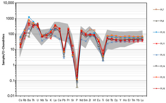
Figure 12.
Select trace and REE analyses of the published data from volcanic suite samples of the SFMs (data compiled by [8,39]), including the reported REE data (grayed field; n = 10) from [8,39,40,41,42,43,44,45,46,47,48,49] compared with select samples from the PLGs (data replicated from Figure 10B) to establish the context for a probable provenance.
Trace element and REE data also suggest similarities between the PLGs and SFMs (Figure 12). There are evident negative Pb, Ti, and P anomalies within the plotted SFM and PLG samples (Figure 12). The SFMs are described as having elevated large ion lithophile elements (LILs) and trends that have certain elements, like Ba, Hf, La, Nb, Rb, Th, U, Y, and Zr increasing with the silica content, and decreasing Co, Cr, Cu, Ni, Sc, Sr, V, and Zn with an increasing silica content [39,40,41,42,43,44,45,46,47,48,49,50], which is visible in the PLG data (Figure 10 and Figure 12). The patterns in both data sets also have negative Eu anomalies [8,39,40,41,42,43,44,45,46,47,48,49] (Figure 12). The PLGs have a negative Pb anomaly compared to the SFMs, which is expected because Pb is a highly incompatible and fluid mobile [37] (Figure 12). Looking at the PLG geochemical data in comparison with the SFMs (Figure 11 and Figure 12), there are many similarities, suggesting a probable provenance connection.
4.2. Keweenawan Volcanic Province and the Midcontinent Rift
The Keweenawan Volcanic Province (KVP) and Midcontinent Rift (MCR) are two of the oldest (~1200–1100 Ma) and largest igneous provinces in the midcontinent [28,29,30,31,56,57]. Although mainly basalt, there are occurrences of gradation to rhyolites (Figure 11; [34]). In most locations, the rocks are buried due to graben subsidence and subsequent infill [34]. Samples from the region show alteration caused by secondary alteration events [33], such as contact metamorphism [32] and/or hydrothermal alterations [32]. We do not see this type of alteration in the PLGs, as they have preserved much of their chemical character.
Throughout the KVP and MCR, the rock types are dominated by mafic species, with rare coeval silicic magmas (i.e., [56,57,58,59,60,61,62,63]). Volcanism in the region was bimodal but primarily tholeiitic [34,56,57,61]. The rare silicic magmas and lavas occur as rhyolitic flows and granitic intrusions, and comprise < ~10% of the total KVP and MCR provinces [58]. For example, samples from Vervoort et al. [57] illustrate the rare occurrence of rhyolites (Figure 11; n = 5) from the KVP and MCR provinces.
Data from the rhyolites in Vervoort et al. (Figure 11; [58]) have a low average Fe2O3 (~3.7–4.4 wt.%) content, whereas the PLGs have a higher average iron content (~1.0–15.16 wt.%; Table 1). The silica contents for the KVP and MCR rhyolite [57] provinces average ~73.3–75.6 wt.%, respectively, which is notably higher than the PLG samples on average (~68.8–75.2 wt.%; Table 1). The KVP and MCR Al2O3 averages are lower in the rhyolitic samples [57]. The PLG average is ~11.8–18.3 wt.% alumina (Table 1), whereas the KVP and MCR rock averages are ~11.8–12.6 wt.%. Also, P2O5 is anomalously low in the PLGs (~0.00–0.28 wt.%; Table 1; Figure 11), while the KVP samples are described as having relatively high concentrations of phosphate (~0.07–1.0 wt.%) [31]. While the KVP and MCR chemistries may fit within the lower range of the PLG oxide averages, many of the other major oxide data do not correlate with the results from previous studies [31,32,33,34,56,57]. As can be seen in Figure 11, very few samples fall within the blue (KVP) or pink fields (MCR), which suggests that the PLGs likely did not originate from the KVP or MCR.
4.3. PLTDs and Glacial Interactions
The PLTDs along the eastern valley wall of the Mississippi River from north of Memphis to south of Natchez records the cyclic incision and subsequent alluviation of the Mississippi River into the coastal plain, driven by eustatic sea level changes from the episodic glaciation during the Pleistocene Epoch. Starnes and Leard [25] reported radiocarbon dates from a core of the first-order PLTD (Figure 2) of the ancestral Mississippi River to have abandoned its previous alluvial plain when approaching the height of the LGM and prior to loessification. The petrology of the gravels of the MMRA points to the outwash of the final retreat of continental glaciers and the subsequent alluviation of the river [16,17,18,22,25].
Test-hole drilling revealed a full succession of this first PLTD, which was proposed by the Mississippi Geological Survey as the Rodney pre-loess terrace allounit (Figure 8 [6,7,13,16,17,18]). The Rodney Terrace is well preserved and mapped in western Jefferson and Adams counties, MS, beneath a thick, even, blanket of loess [6,25]. The basal fluvial gravels of the Rodney Terrace sit a few feet above sea level and are in direct hydraulic connectivity with the MMRA. The exposure of these basal gravels of the Rodney Terrace are only limited to observation along the cutback of Mississippi River near the vicinity of Natchez at historically low water levels, where they unconformably overlay clays of the Miocene Pascagoula Formation [59].
The second-order, and significantly higher, PLTD proposed by previous authors as the Rawhide Terrace allounit (e.g., [6,7,13,14,16,17,18,22,26,30]) has been mapped as a continuous deposit in portions of Warren and Yazoo counties, with erosional outliers separated by the Big Black River in western Hinds County, near Edward [7,13,16,17,25]. Test-hole drilling revealed that a full succession of the Rawhide Terrace (Figure 8) is well preserved and mappable along its westernmost extent between the towns of Vicksburg and Satartia, MS, in Warren and Yazoo counties, beneath a thick, even, blanket of loess [13]. The basal fluvial gravels of the Rawhide Terrace sit nearly level, benched ~220 ft above sea level, uncomfortably overlying marine and deltaic deposits of the Eocene–Oligocene age formations of the Jackson, Vicksburg, and Grand Gulf groups [13]. The best exposures of the Rawhide Terrace are found along the valley wall of the Big Black River in eastern Warren county and western Hinds county, where it is exposed in the high walls of extensive aggregate quarries utilizing it as an economic resource [7,13,16,17,18].
Here, the petrology of the gravels of the Rawhide Terrace have been extensively described by the State Survey and is directly related to the intense glacial outwash in the valley [6,7,13,15,19,23,26,27,28,30,59]. The abundance of glacially faceted and striated stones, Sioux Quartzite, and ice-rafted boulders is evidence of the proximity of the lower Mississippi Valley to the glacial front (Figure 5 and Figure 6 [6,7,13,15,19,23,26,27,28,30,59]). This association may coincide with the maximum extent of continental glacial coverage in North America during the Pleistocene (Figure 13). The abundant Sioux Quartzite clasts in the Rawhide Terrace range from cobble-sized clasts to boulders, and are among Paleozoic chert (Figure 4) and sandstone boulders (Figure 5) that weigh in excess of a ton that had to have been ice-rafted into the coastal plain [6,7,13,15,19,23,26,27,28,30,59]. The presence of Sioux Quartzite in the PLTDs is significant (Figure 5 and Figure 6) because it indicates the re-routing of the Missouri River into the lower Mississippi Valley along the glacial margin during the incursion of the Minnesota glacial lobe into Missouri, formerly attributed to the “Kansan” glacial stage [6,7,13,15,19,23,26,27,28,30,59].

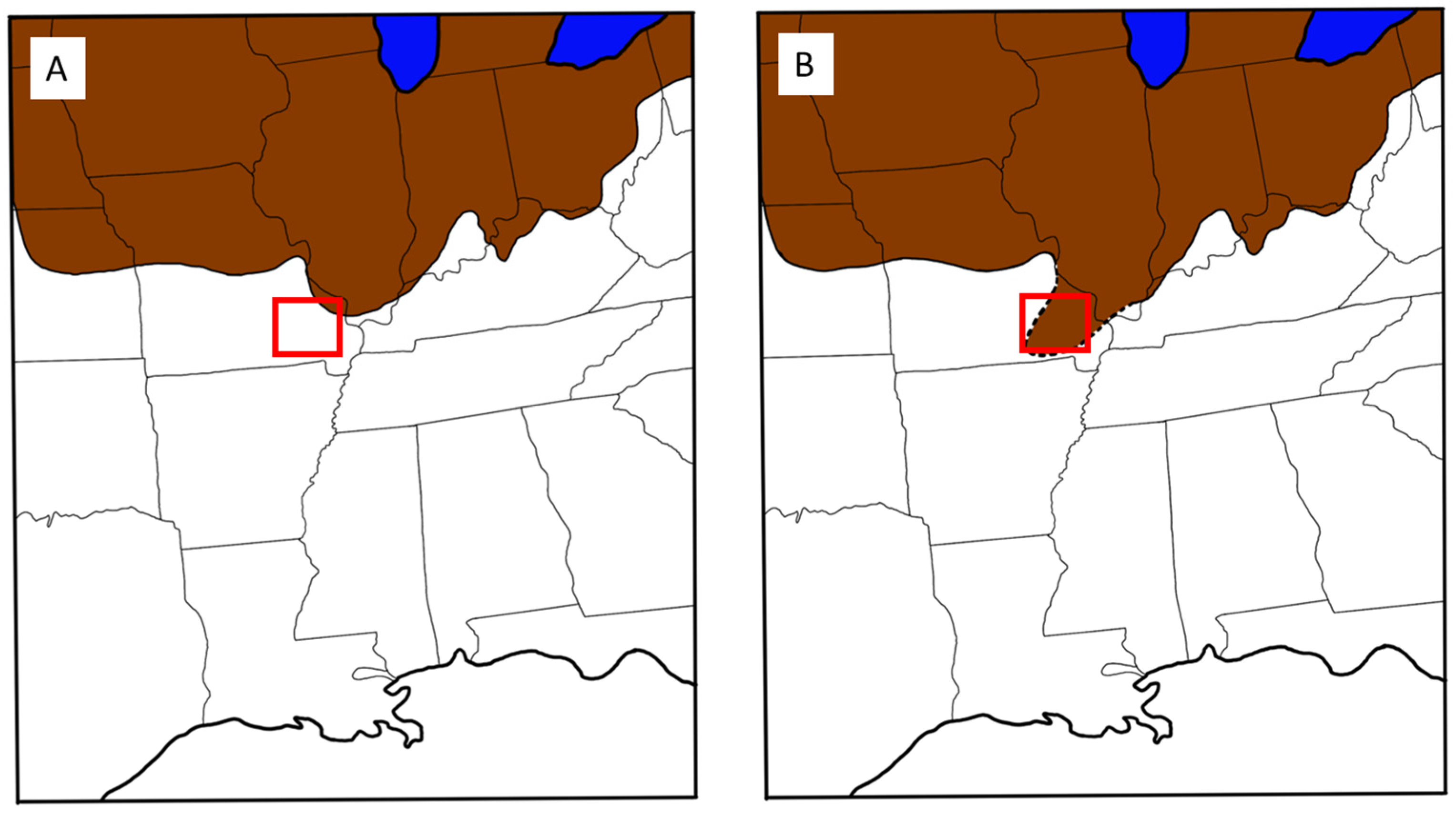
Figure 13.
(A) Current published data of glacial fronts infiltrating into the US during the Pleistocene (~600,000 years ago; [27,28]; modified from map provided in [14]). (B) Revised glacial front (dotted line) based on geochemical provenance data from the MS PLGs and indications of a possible provenance within the SFMs. Brown indicates the Independence “Kansan” glaciation and the red box is the SFM location within the state of Missouri. Blue is Lake Michigan and Lake Superior in both.
Previous work limits the maximum extent of the Pleistocene glaciation on the midcontinent to moraines of northeastern Missouri above the elevation of the northern bank of the Missouri River. The presence, preservation, relative abundance, and clast size of the igneous rocks in the Rawhide Terrace from this study suggests a more direct association between the glacial front and the SFMs (Figure 13). Early studies in the SFM region have suggested this, but those ideas were abandoned for lack of sufficient supporting evidence. It is proposed here that, whereas all of the evidence in the SFM has long eroded away, the supporting evidence is recorded in the glacial outwash of the ancestral Mississippi River into the Coastal Plain by the gravel petrology of the Rawhide PLTD.
5. Conclusions
The Mississippi pre-loess terrace gravel volcanic clasts best correlate petrographically and geochemically to the St. Francois Mountains source in southeast Missouri. Geochemistry backs up the previous hand sample analysis suggesting this. Stratigraphic context places the PLTDs in relation with the LGM, and the data presented here, as well as the previous data, fit with the old nomenclature of Independence, “Kansan”, or “pre-Illinois” glaciation; however, newer nomenclature has yet to be fully defined. This means that the Independence “Kansan” glaciation penetrated further southwest than previously recorded. The significance of the detrital clasts of siliceous volcanic rock within the Rawhide Terrace, where no other igneous gravel constituents are known anywhere else in the Pleistocene, suggest the glacial front of a “Missouri Lobe” had to have reached as far southwest as the SFMs (Figure 13B). This would be required in order to sample the SFMs and to provide a provenance for the Pleistocene PLGs observed in the ancient Mississippi River Terraces. The work performed here focused on the petrology of the clastic materials deposited by the Mississippi River into the coastal plain, which was the main drainage for the midcontinent during Pleistocene glacial cycles, and future research should focus on identifying the localities within the SFMs that could provide additional corroborating evidence to enhance the understanding of the maximum cyclic glaciation of the North American midcontinent and its relation to PLTDs, and the evolution of the Mississippi River.
Supplementary Materials
The following supporting information can be downloaded at: https://www.mdpi.com/article/10.3390/geosciences14120340/s1. Table S1: Raw data of PLGs; Data were normalized using CIPW Norm calculator from Hollocher [37] (after [38]). The normative calculator uses wt.% of oxides analyzed via ICP-MS to help calculate the normative minerals in the sample which may differ from modal observations in photomicrographs and hand-sample analysis.; Table S2: Fusion ICP-MS data provided by ActLabs with quality control data; Figures S1–S7: Photomicrographs of the PLG samples; Figure 8: Full-sized .png of the Vinzant #1 Borehole Log with the horizons plotted; and Figure S8.png of the Carrol Potter #2 Borehole Log.
Author Contributions
Conceptualization, M.G.P. and J.E.S.; methodology, M.G.P. and J.N.G.; validation, M.G.P., J.N.G., B.F.P. and J.E.S.; formal analysis, M.G.P. and J.N.G.; investigation, M.G.P. and J.E.S.; resources, J.N.G.; data curation, M.G.P.; writing—original draft preparation, M.G.P. and J.E.S.; writing—review and editing, M.G.P., J.N.G., B.F.P. and J.E.S.; visualization, M.G.P. and J.E.S.; supervision, J.N.G.; project administration, M.G.P., J.E.S. and J.N.G.; funding, J.N.G. All authors have read and agreed to the published version of the manuscript.
Funding
This research received no external funding.
Data Availability Statement
The data presented in this study are available for download via the Supplementary Materials in Table S1 above or by request from the corresponding author. The Vinzant #1 Borehole is available in the MDEQ E-Log database as E-Log file# F-0053 on their website (mdeq.ms.gov; accessed 15 March 2024) or at https://geology.deq.ms.gov/environmental/boreholes/docs/logs/149-Warren/f/053/eld523149f0053a.png (accessed on 15 February 2024). The Carrol Potter #2 Borehole is available in the MDEQ E-Log database as E-log file# U-0142 at https://geology.deq.ms.gov/environmental/boreholes/docs/logs/163-Yazoo/u/142/eld523163U0142a.png (accessed on 13 September 2024).
Acknowledgments
Thank you to the Mississippi Department of Environmental Quality’s Mississippi Office of Geology (Mississippi Geological Survey) for access to and use of the pre-loess terrace gravels. Thank you to David Dockery III RPG for allowing us to work with MDEQ and aid in the understanding of the ancestral river deposits of the Mississippi River. Thank you to the Geology and Geological Engineering Department Faculty and Staff of the University of Mississippi for their enthusiastic and unwavering support.
Conflicts of Interest
The authors declare no conflicts of interest.
References
- Moody, C. Mesozoic Igneous Rocks of the Northern Gulf Coastal Plain. AAPG Bull. 1987, 33, 1410–1428. [Google Scholar]
- Kidwell, A.L. Mesozoic Igneous Activity in the Northern Gulf Coastal Plain. Ph.D. Thesis, University of Chicago, Chicago, IL, USA, 1949; 316p. [Google Scholar]
- Zartmann, R. Geochronology of Some Alkalic Rock Provinces in Eastern and Central United States. Annu. Rev. Earth Planet. Sci. 1977, 5, 250–253. [Google Scholar] [CrossRef]
- Cox, R.; VanArsdale, R. Hotspot Origin of the Mississippi Embayment and Its Possible Impact on Contemporary Seismicity. Eng. Geol. 1997, 46, 201–216. [Google Scholar] [CrossRef]
- Dockery, D.; Thompson, D. The Geology of Mississippi; The University Press of Mississippi: Jackson, MS, USA, 2016; ISBN 978-1-4968-1313-9. [Google Scholar]
- Starnes, J.; Leard, J. OF-295 Geologic Map of the Rodney Quadrangle, Jefferson and Claiborne Counties, Mississippi; Mississippi Department of Environmental Quality, Office of Geology: Jackson, MS, USA, 2019.
- Starnes, J.; Leard, J.; Regielli, A. OF-323 Geologic Map of the 1:100,000 Greenwood Quadrangle Bolivar, Sunflower, Tallahatchie, Leflore, Carroll, Grenada, Washington, and Coahoma Counties, Mississippi; Mississippi Department of Environmental Quality, Office of Geology: Jackson, MS, USA, 2021.
- du Bray, E.; Aleinkoff, J.; Day, W.; Neymark, L.; Burgess, S. Petrology and Geochemistry of 1.48 to 1.45 Ga Igneous Rocks in the St. Francois Mountains Terrane, Southeast Missouri. U.S. Geol. Survery Prof. Pap. 2021, 1866, 88. [Google Scholar] [CrossRef]
- Walker, J.; Geissman, J. Geologic Time Scale v. 6.0. Geol. Soc. Am. 2022. [Google Scholar] [CrossRef]
- Cox, R.; VanArsdale, R. The Mississippi Embayment, North America: A First Order Continental Structure Generated by the Cretaceous Superplume Mantle Event. J. Geodyn. 2002, 34, 163–174. [Google Scholar] [CrossRef]
- Duncan, R. Age Progressive Volcanism in the New England Seamounts and the Opening of the Central Atlantic Ocean. J. Geophys. Res. 1984, 89, 9980–9990. [Google Scholar] [CrossRef]
- Gifford, J.; Vitale, E.; Platt, B.; Malone, D.; Widanagamage, I. Detrital Zircon Provenance and Lithofacies Associations of Montmorillonitic Sands in the Maastrichtian Ripley Formation: Implications for Mississippi Embayment Paleodrainage Patterns and Paleogeography. Geosciences 2020, 10, 80. [Google Scholar] [CrossRef]
- Leard, J.; Starnes, J.; Palmer, T. OF-329 Geologic Map of the Phoenix Quadrangle Yazoo, Warren, and Hinds Counties, Mississippi; Mississippi Department of Environmental Quality, Office of Geology: Jackson, MS, USA, 2023.
- Starnes, J.; Pizarro, M. Pre-Loess Gravels Communication Line 2024.
- Starnes, J. Igneous Rocks of the St. Francois Mountains and Pre-Historic Artifacts in Mississippi. Miss. Acad. Sci. 86th Annu. Meet. 2022, 67, 94–95. [Google Scholar]
- Leard, J.; Palmer, T.; Starnes, J.; Ozbim, B. Geologic Map of the Eldorado 7.5-Minute Quadrangle 2024; Mississippi Department of Environmental Quality, Office of Geology: Jackson, MS, USA, 2024.
- Leard, J.; Palmer, T.; Starnes, J.; Ozbim, B. Geologic Map of the Oak Ridge 7.5-Minute Quadrangle 2024; Mississippi Department of Environmental Quality, Office of Geology: Jackson, MS, USA, 2024.
- Leard, J.; Palmer, T.; Starnes, J.; Ozbim, B. Geologic Map of the Queens Hill Lake 7.5-Minute Quadrangle 2024; Mississippi Department of Environmental Quality, Office of Geology: Jackson, MS, USA, 2024.
- Morse, W. Geologic Condiditons Governing Sites of Bridges and Other Structures. Miss. Geol. Surv. Bull. 1935, 27, 19. [Google Scholar]
- Fisk, H.; LaBlanc, R.; Mabrey, P.; Krinitzsky, E. Geological Investigations of Gravel Deposits in the Lower Mississippi-Valley and Adjunct Uplands. Miss. River Comm. U.S. Army Corps Eng. U.S. Waterw. Exp. Stn. Tech. Mem. 1949, 3, 58. [Google Scholar]
- Snowden, J.; Priddy, R. Geology of Mississippi Loess. Miss. Geol. Surv. Bull. 1968, 111, 13–203. [Google Scholar]
- Starnes, J.; Segrest, B.; Leard, J. Lithic Materials: Pre-Loess Terrace Deposits: From Fact Sheet 3: Mississippi’s Native Lithic Materials Source Map. Available online: https://www.mdeq.ms.gov/geology/work-areas/surface-geology/lithic materials/ (accessed on 15 February 2024).
- Dockery, D. Toward a Revision of the Generalized Stratigraphic Column of Mississippi. Miss. Geol. 1996, 17, 1–18. [Google Scholar]
- Armstrong, E.; Hopcroft, P.; Valdes, P. A Simulated Northern Hemisphere Terrestrial Climate Dataset for the Past 60,000 Years. Sci. Data 2019, 6. [Google Scholar] [CrossRef]
- Starnes, J.; Leard, J. Radiometric Dates from A Core of the Rodney Pre-Loess Terrace Deposit in Jefferson County, Mississippi, and the Implications for the Age and Evolution of the Mississippi Alluvial Plain. J. Miss. Acad. Sci. 2024, 69, 126. [Google Scholar]
- Leard, J.; Starnes, J.; Palmer, T. OF-336 Geologic Map of the Natchez Quadrangle Adams County, Mississippi 2022; Mississippi Department of Environmental Quality, Office of Geology: Jackson, MS, USA, 2022.
- Frye, J.C.; Leonard, A.B. Pleistocene Geology of Kansas. Kans. Geol. Surv. Bull. 1952, 99. [Google Scholar]
- Dort, W. Salient Aspects of the Terminal Zone of Continental Glaciation in Kansas; Kansas Geological Survey: Lawrence, Kansas, 1987. [Google Scholar]
- Aber, J. Reappraisal of the Glaciation of Northeast Kansas. Trans. Kans. Acad. Sci. 2022, 125, 41–51. [Google Scholar] [CrossRef]
- Starnes, J.; Peacock, K. Glacially Faceted Stone from the Pre-Loess Terrace Deposits in Mississippi. Miss. Acad. Sci. 78th Annu. Meet. 2014, 59, 77. [Google Scholar]
- Hahnenberg, J. The Petrology and Geochemistry of the Keweenawan Diabase Dikes in Ontonagon, Gogebic, Iron, and Dickinson Counties, Michigan; Western Michigam University: Kalamazoo, MI, USA, 1981. [Google Scholar]
- Nelson, N. A Petrologic and Geochemical Study of Granophyric Granite in the Roof of the Keweenawan Duluth Complex, Eagle Mountain, Cook County, Minnesota; The University of Minnesota: Minneapolis, MN, USA, 1991. [Google Scholar]
- Siefert, K.; Anderson, R. Geochemistry of Buried MidcontinentRift Volcanic Rocks in Iowa: Data from Well Samples. JIAS 1996, 103, 63–73. [Google Scholar]
- Green, J. Physical Volcanology of Mid-Proterozoic Plateau Lavas: The Keweenawan North Shore Volcanic Group, Minnesota. GSA Bull. 1989, 101, 486–500. [Google Scholar] [CrossRef]
- Hoffman, E.; Dunn, B. Sample Preparation and Bulk Analytical Methods for PGE. Act. Lab. 2002. [Google Scholar]
- ActLabs Activation Laboratories Geochemistry Schedule of Services and Fees 2024. Available online: https://actlabs.com/wp-content/uploads/2024/01/Actlabs-Geochemistry-Schedule-of-Services-2024-–-USD.pdf (accessed on 30 March 2024).
- Rollinson, H. Using Geochemical Data: Evaluation, Presentation, Interpretation, 2nd ed.; Pearson, Routledge, Taylor & Francis: London, UK, 1993; ISBN 13: 987-0-582-06701-1. [Google Scholar]
- Hollocher, K. CIPW Norm Calculation Program 2004. Available online: https://www.google.com/url?sa=t&rct=j&q=&esrc=s&source=web&cd=&ved=2ahUKEwjKqaXM45iKAxVCGFkFHe8mDDgQFnoECB0QAQ&url=https%3A%2F%2Fwww.whitman.edu%2Fgeology%2Fwinter%2FPetrology%2FCIPW%2520Norm%2520Hollacher.xls&usg=AOvVaw33D5ladPAtO84aMv7E_f1v&opi=89978449 (accessed on 30 March 2024).
- Johanssen, A. A Descriptive Petrography of the Igneous Rocks, Vol 1. Introduction, Textures, Classification, and Glossary. J. Geol. 1931, 40, 182–185. [Google Scholar]
- Whitney, D.; Evans, B. Abbreviations for Names of Rock-Forming Minerals. Am. Mineral. 2010, 95, 185–187. [Google Scholar] [CrossRef]
- McDonough, W.; Sun, S. The Composition of the Erath. Chem. Geol. 1995, 120, 223–253. [Google Scholar] [CrossRef]
- Sun, S.; McDonough, W. Chemical and Isotopic Systematics of Oceanic Basalts: Implications for Mantle Composition and Processes. Magmat. Ocean. Basins 1989, 42, 313–345. [Google Scholar] [CrossRef]
- Granitto, M.; du Bray, E.; Day, W.; Meighan, C.; Slack, J.; Ayuso, R. Geochemical and Modal Data for Mesoproterozoic Igneous Rocks of the St. Francois Mountains, Southeast Missouri. U.S. Geological Survery Data Release. Available online: https://www.usgs.gov/data/geochemical-and-modal-data-mesoproterozoic-igneous-rocks-st-francois-mountains-southeast (accessed on 20 March 2024).
- Granitto, M.; du Bray, E.; Day, W.; Meighan, C.; Slack, J.; Ayuso, R. Data Release Supporting Compilation of New and Previously Published Geochemical and Modal Data for Mesoproterozoic Igneous Rocks of the St. Francois Mountains, Southeast Missouri: U.S. Geological Survey Data Release 2018. Available online: https://pubs.usgs.gov/ds/1080/ds1080.pdf (accessed on 20 March 2024).
- Anderson, R. Ignoues Petrology of the Taum Sauk Area, Missouri. Ph.D. Thesis, Washington University, St. Louis, MO, USA, 1962. [Google Scholar]
- Bickford, M.; Sides, J.; Cullers, R. Chemical Evolution of Magmas in the Proterozoic Terrane of the St. Francois Mountains Southeastern Missouri—Field, Petrographic, and Major Element Data. J. Geophys. Res. 1981, 86, 10365–10386. [Google Scholar] [CrossRef]
- Brown, V. The Precambrian Volcanic Stratigraphy and Petrology of the Des Arc NE 7.5 Minute Quadrangle, South Centrl St. Francois Mountains, Missouri. Ph.D. Thesis, Iniversty of Missouri, Rolla, MO, USA, 1983. [Google Scholar]
- Day, W.; Granitto, M. Geologic Field Notes Ad Geochemical Analyses of Outcrop and Drill Core from Mesoproterozoic Rocks and Iron-Oxide Deposits and Prospects of Southeast Missouri; U.S. Geological Survey: Reston, VA, USA, 2014.
- Day, W.; Slack, J.; Ayuso, R.; Seeger, C. Regional Geolgic and Petrologic Framework for Iron Oxide + Apatite + Rare Earth Element and Iron Oxide Copper-Gold Deposits of the Mesoproterozoic St. Francois Mountains Terrane, Southeast Missouri, USA. Econ. Geol. 2016, 111, 1825–1858. [Google Scholar] [CrossRef]
- Kisvarsanyi, E. Petrochemistry of a Precambrian Igneous Province, St. Francois Mountains, Missouri. Mo. Geol. Surv. Water Resour. Rep. Investig. 1972, 96, 97p. [Google Scholar]
- Menuge, J.; Brewer, T.; Seeger, C. Petrgenesis of Metaluminou A-Type Rhyolites from the St. Francois Mounains, Missouri and the MEsoproterozoic Evolution of the Southern Laurentian Margin. Precambrian Res. 2002, 113, 269–291. [Google Scholar] [CrossRef]
- Pippin, C. Geology and Geochemistry of the Cope Hallow Formation and the Western St. Francois Muntains, Southeast Missouri. Master’s Thesis, Northern Illinois University, DeKalb, IL, USA, 1996. [Google Scholar]
- Sylvester, P. Geology, Petrology, and Tectonic Setting of the Mafic Rocks of the 1480 Ma Old Granite/Rhyolite Terane of Missouri, USA. Ph.D. Thesis, Washington University, St. Louis, MO, USA, 1984. [Google Scholar]
- Walker, J.; Pippin, C.; Cameron, B.; Patino, L. Tectonic Insights Provided by Mesoproterozoic Mafic Rocks of the St. Francois Mountains, Southeastern Missouri. Precambrian Res. 2002, 117, 251–268. [Google Scholar] [CrossRef]
- U.S. Geological Survey the National Geochemical Survey Database 2013. Available online: https://www.usgs.gov/centers/gggsc/science/national-geochemical-database (accessed on 20 March 2024).
- Huber, N.K. The Portage Lake Volcanics (Middle Keweenawan) on Isle Royale, Michigan; Geologicl Survey; United States Geological Survey: Isle Royale, MI, USA, 1973; p. 44.
- Vervoort, J.; Wirth, K.; Kennedy, B.; Sandland, T.; Harpp, K. The Magmatic Evolution of the Midcontinent Rift: New Gechronologic and Geochemical Evidence from Felsic Magmatism. Precambrian Res. 2007, 157, 235–268. [Google Scholar] [CrossRef]
- Basaltic Volcanism Study Project Pre-Teritary Continental Flood Basalts. In Basaltic Volcanism on the Terrestrial Planets; Pergamon Press: New York, NY, USA, 1981; pp. 30–77.
- Brannon, J. Geochemistry of Successive Lava Flows of the Keweenawan North Shore Volcanic Group. Ph. D. Thesis, Washington University: St. Louis, MO, USA, 1984.
- Dosso, L. The Nature of the Precambrian Subcontinental Mantle: Isotopic Study (Sr, Pb, Nd) of the Keweenawan Volcanism of the North Shore of Lake Supeior. Ph.D. Thesis, University of Minnesota, Minneapolis, MI, USA, 1984. [Google Scholar]
- Green, J. Geology of Keweenawan Extrusive Rocks. Geol. Soc. Am. 1982, 156, 47–55. [Google Scholar]
- Lightfoot, P.; Sutcliffe, R.; Doherty, W. Crustal Contamination Identified in Keweenawan Osler Group Tholeiites, Ontario: A Trace Elemetn Perspective. J. Geol. 1991, 99, 739–760. [Google Scholar] [CrossRef]
- Morey, G.; Mudrey, M., Jr. Keweenawan Volcanic Rocks in East-Central Minnesota. Geol. Minn. 1972, A Centennial Volume, 425–430. [Google Scholar]


Disclaimer/Publisher’s Note: The statements, opinions and data contained in all publications are solely those of the individual author(s) and contributor(s) and not of MDPI and/or the editor(s). MDPI and/or the editor(s) disclaim responsibility for any injury to people or property resulting from any ideas, methods, instructions or products referred to in the content. |
© 2024 by the authors. Licensee MDPI, Basel, Switzerland. This article is an open access article distributed under the terms and conditions of the Creative Commons Attribution (CC BY) license (https://creativecommons.org/licenses/by/4.0/).