Abstract
The Las Cruces intrusive suite is located at the southern extent of the Baja California Peninsula in northwestern Mexico. The suite constitutes the northern part of the Los Cabos Batholitic Complex. It is correlated with extensive Cretaceous magmatic activity extending across California and the Baja Peninsula, known as the Peninsular Ranges Batholith. Despite its significance for understanding the regional tectonic and magmatic evolution, detailed information to fully support this correlation remains limited. This work provides new cartographic and structural data of the units comprising the intrusive suite and the temporal relationships between lithological units, supported by U-Pb zircon geochronology. The suite consists of granite in its central part, tonalite displaying magmatic foliation at its NW and SE margins, and two gabbro apophyses along the western edge. The host rocks consist of intercalations of hornblende and biotite schists, forming screens and roof pendants. Late magmatic felsic dikes, derived from the granite, intrude into the suite units. Five new U-Pb zircon age determinations indicate that the suite has a normal crystallization history with ages from 103.5 ± 1.2 to 97.6 ± 0.8 Ma for the tonalite and from 93.6 ± 0.7 to 95.0 ± 0.9 Ma for the granite. The gabbro is the oldest intrusive unit, with previous U-Pb zircon ages reported near 109 ± 2.3 and 102.3 ± 2.9 Ma. Structural analysis indicates that the gabbro and tonalite were emplaced during an E–W synmagmatic compressional event, evidenced by N–S oriented magmatic foliation, aligning subparallel to the granite and metasedimentary screens contacts. Later, the granite was emplaced during a compressional stress relaxation phase, causing the tonalite dissection and forming the current suite margins. The calculated U-Pb ages for the Las Cruces intrusive suite and reported geochemical and geophysical data from the northern Baja California Peninsula support its correlation with the Peninsular Ranges batholith.
1. Introduction
From the Late Cretaceous to the Cenozoic, the tectonic evolution of western North America was primarily controlled first by terrain accretion and later by the continuous subduction of the now extinct Farallon Plate beneath the North American Plate [1,2,3]. During this period, a magmatic arc developed along the western margin of the continent, which began to separate during the Late Miocene due to rifting associated with the Gulf of California. Subduction-related magmatism in this region is characterized by the presence of numerous batholiths, which in California (USA) and the Baja California Peninsula are generically known as Peninsular Ranges Batholith (PRB) [4]. In the interior of Mexico, similar batholitic structures are referred to by various regional names, including the Coastal Sonoran Batholith, Sinaloan Batholith, and Puerto Vallarta Batholith [5]. Multiple studies of the PRB have addressed aspects including the petrography, geochemistry, structures, and geochronology of the associated intrusive bodies, e.g., [2,3,4,6,7,8,9,10,11,12]. Most of these studies have focused on the northern end of the Baja California Peninsula, with less attention given to its southern extent. This is primarily because the PRB outcrops continuously from California (USA) to latitude 28°N in the Baja California Peninsula [13]. To the south, the PRB is partially covered by Oligocene–Miocene volcano-sedimentary rocks of the Comondú Group [14] in the north to the latitude of La Paz (24° N; Figure 1). The coverage of the PRB is partial between 28 and 24° N, on the eastern margin of the Baja California peninsula, with isolated Cretaceous intrusive outcrops due to the tectonic activity of the Gulf of California rift [15,16]. From the La Paz latitude to the southern tip of the Baja California Peninsula, extensive exposures of crystalline rocks consisting of Cretaceous granitoids are known as the Los Cabos Batholithic Complex (LCBC) [4]. Initially, some authors considered the LCBC as an allochthonous block relative to the Baja California Peninsula, e.g., [1,17]. Still, recent geochemistry and geophysical studies consider it a southern extension of the PRB [4,18,19,20]. Analysis of the geological characteristics and regional correlations of the LCBC has been addressed in various studies, primarily focusing on lithological relationships as defined by multiple cooling ages [21,22,23]. Only in scarce works [20], were reported Cretaceous crystallization ages for intrusive rocks from the LCBC in this region and made a correlation with the PRB. The presence of a structural lineament, known as the La Paz Fault [24], has contributed to the interpretation of the LCBC as a separate block structurally distinct from the PRB, as it roughly separates Cretaceous crystalline rocks from Neogene sedimentary and volcano-sedimentary units. This hypothesis has been discussed in subsequent studies [21,25], where such a structure is dismissed based on structural analysis and thermochronology using fission-track dating in apatites and zircons from the LCBC.
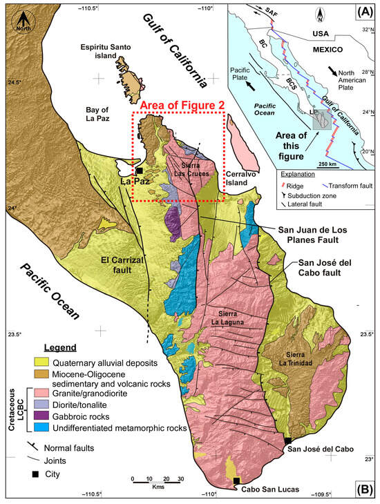
Figure 1.
(A) Main tectonic features from NW México, related to the North American and Pacific plate boundaries. The main tectonic features from NW México are related to the boundaries of the North American and Pacific plates. SAF: San Andreas Fault, BC: Baja California state, BCS: Baja California Sur state. (B) Regional geology map of the southernmost tip of the Baja California peninsula, showing the main lithological units that compose the Los Cabos Batholitic Complex (LCBC), dissected by transpeninsular faults. The area considered in detail in the present work is shown as Figure 2.
The study area corresponds to the northernmost extent of the LCBC and consists of an intrusive suite emplaced in pre-batholithic rocks of possible Early Cretaceous age. Towards its western edge, the intrusive suite is discordantly overlain by Neogene sedimentary and volcano-sedimentary rocks (Figure 1). To define the relationships between the intrusive rocks at the northern end of the LCBC and their host rocks, a comprehensive geological study was conducted, including geological mapping, structural analysis, and U-Pb zircon dating to determine crystallization ages for the intrusive units, comprising the magmatic suite known as Las Cruces.
2. Geological Setting
The Las Cruces Intrusive Suite (LCIS) is located to the east of La Paz city, in the sierra of the same name, also referred to as Sierra Las Cacachilas, situated on the eastern margin of the Baja California peninsula (Figure 1). The LCIS constitutes the northern edge of the Los Cabos batholithic complex [4] and is well exposed throughout Sierra Las Cruces. It is discordantly overlain in some areas by Oligocene sedimentary rocks, Miocene volcanic units, and Pliocene–Quaternary sediments. At the latitude of the Sierra Las Cruces, the suite reaches a width of approximately 22 km in a semi-circular shape, with pre-intrusive metasedimentary host rocks remaining as screens and roof pendants. The LCIS comprises four distinct intrusive units, ranging from gabbro to granite, emplaced within a sequence of metasedimentary rocks of possible early Cretaceous age. These intrusives were previously reported as undifferentiated Cretaceous granitic rocks, similar to those of the Peninsular Ranges Batholith [24]. Several units composing the Sierra Las Cruces were roughly described in previous studies [26] and are included in this work. The LCIS is mainly composed of granite in its central part, while the edges display outcrops of foliated tonalite, with metasedimentary rocks forming screens and roof pendants. There are small outcrops of gabbro towards the western edge of this suite. Transpeninsular faults associated with the Gulf of California extension segmented the southern end of the Baja California peninsula, creating a morphotectonic setting of basins (half-grabens) and mountain ranges (Figure 1).
On the western edge, the LCIS is discordantly covered (in a buttress unconformity style) by Neogene volcano-sedimentary rocks and Quaternary sediments. A regional structural lineament-oriented NNW-SSE, proposed as the La Paz fault in previous studies [24], suggests that this is a fault that separates intrusive rocks of the LCBC from Neogene volcano-sedimentary rocks. In the study area, this lineament is visible in aerial images, and our field analysis determined that the lineament corresponds to the contact between the foliated tonalite and granite, implying the absence of a tectonic structure, as previously proposed. The northeastern and eastern ends of the LCIS are the Gulf of California coastline, where foliated tonalite and granite are widely exposed. To the south of the LCIS, the morphological and mesoscopic characteristics of the intrusive suggest a compositional change, potentially corresponding to another granitic intrusion. However, they could be contemporaneous or different facies of the same pluton.
The Las Cruces Intrusive Suite
The Las Cruces Intrusive Suite (LCIS) is composed of four lithological units, ranging from gabbro to granite (sensu stricto), emplaced within a sequence of metasedimentary rocks of possible Early Cretaceous age (Figure 2). These units have been reported previously as Cretaceous granitic rocks similar to those of the PRB, but without detailed mapping [24]. The LCIS predominantly consists of granite at its center. At the same time, magmatic foliated tonalite is exposed at the edges, with screens and roof pendants of metasedimentary rocks (Figure 2). Gabbros occur on the western side of the area, with two small outcrops present.
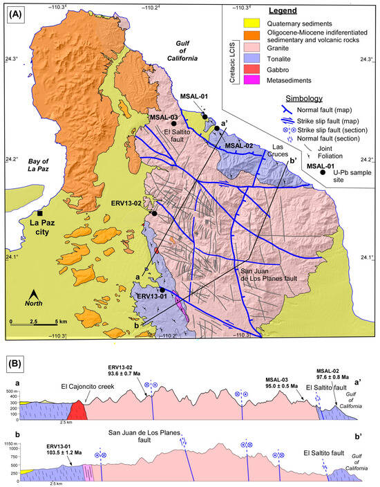
Figure 2.
(A) Geological map of the Las Cruces Intrusive Suite (LCIS), mainly composed of granite and tonalite. (B) Geological cross-section (a,a’) shows gabbro outcrops on the western side, while cross-section (b,b’) shows metasedimentary screens that align with the tonalite magmatic foliation.
The Early Cretaceous metasedimentary host rocks of the LCIS consist of intercalated hornblende and biotite schists, along with calc-silicate rocks, with amphibolite facies metamorphism. These rocks are located in the western and eastern ends of the Sierra de Las Cruces as screens and roof pendants. The contacts with the tonalite are abrupt, characterized by elongated outcrops, and oriented almost N–S. Structurally, there is a parallelism with a N–S trend and sub-vertical eastward tilting between the magmatic foliation, stratification, and the contacts between the tonalite and the metasediments (Figure 3).
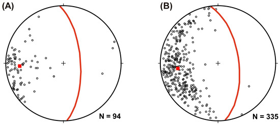
Figure 3.
(A) Poles to foliation in metasedimentary rocks. (B) Poles to magmatic foliation in the tonalite. The mean plane and pole for foliations are presented in red lines and squares, respectively in both datasets. This indicates a similar structural trend for metasediments and tonalite foliations from the LCIS.
The gabbro is the oldest intrusive unit in the LCIS, known regionally as the La Palmilla Gabbro in regional studies [26]. Outcrops of gabbro occur on the western edge of the LCIS, forming two small apophyses with a combined area of 0.3 km2 (Figure 2). The gabbro displays a coarse to pegmatitic texture, with intergrowths of euhedral hornblende and plagioclase, forming schlieren structures. The gabbro has intrusive contact with the younger tonalite. Field observations and petrographic characteristics suggest a correlation with the El Novillo gabbroic pluton located further south of the portion of the study area, with reported U-Pb zircon ages of 109 ± 2.3 and 102.3 ± 2.9 Ma (Figure 1) [20].
The tonalite unit is chronologically younger than the gabbro. It is locally referred to as La Buena Mujer Tonalite [26], which crops out as bounding bands on both edges of the LCIS (Figure 2). At the western end, toward the La Paz basin, the tonalite is discordantly overlain by Cenozoic volcanic and sedimentary rocks. In contrast, to the northeast it is bounded by the Gulf of California coast and to the east by recent sediments in the San Juan de Los Planes basin (Figure 2).
Mineralized zones have historically been mined along the eastern margin of the Las Cruces granite [27,28]. These mineralized zones consist of quartz and sulfide veins with gold and silver contents, located in shear zones and associated with an epithermal system [28]. In the NE region, the contact between the tonalite and granite is partly intrusive and, in places, follows the El Saltito fault [29]. The fault contact is oriented NW–SE and slightly curved, with dip-slip kinematics and upper plate displacement to the east (Figure 2B). At the NW end, the granite is discordantly overlain by outcrops of Oligocene–Miocene sedimentary and volcanic rocks (Figure 2), corresponding to the basal part of the Comondú Group [14,30].
3. Materials and Methods
Field observations were combined with U-Pb zircon geochronology to investigate the temporal intrusive relationships among the Las Cruces Intrusive Suite (LCIS) lithological units. Five samples were collected and analyzed using U-Pb zircon geochronology, including samples from the edges of the LCIS, consisting of tonalite with magmatic foliation and one diorite sample from enclaves within the tonalite. Additionally, two samples from the granite unit that forms the core of this suite were dated (Figure 2).
Sample processing and analysis were conducted at the Mineral Characterization Laboratory (CARMINLab) at the Geosciences Center of UNAM. Zircon grains were separated using magnetic and density methods (Frantz magnetic separator; heavy liquids: methylene iodide—MEI). Grains were then mounted in epoxy resin, sectioned along their c-axis, and examined under optical and scanning electron microscopy (HITACHI S–3100H scanning electron microscope equipped with a Deben UK Limited Centaurus 300–650 nm cathodoluminescence detector (SEM–CL)). The generated images permitted the selection of potential sites for U-Pb analysis, based on the texture and particularly the zoning related to compositional changes in the zircon grains, as well as detecting and excluding potential inclusions, metamorphic overgrowths, or inherited components. Zircon age determinations were performed using a Resonetics Resolution M50 laser ablation system, which includes a 193 nm wavelength LPX 220 excimer laser operated with an argon fluoride (ArF) gas mixture [31,32]. Data reduction for age calculations was performed with Iolite software v. 4 [33], considering the Mean Square of Weighted Deviates (MSWD) for statistical reliability, with a threshold of 2.5. Isotopic results were plotted on concordia diagrams using the Isoplot 3.0 program (“add-in” for Excel®) [34].
4. Results
4.1. Field Observations
The tonalite outcrops are characterized by a distinctive strong to incipient magmatic foliation, visible at the outcrop level and under the hand lens (Figure 4A,B,D). Preferential alignment of minerals such as hornblende and biotite, as well as the same trend-oriented dioritic enclaves, are distinguishable at the outcrop scale (Figure 4A,B). It also features fine-grained diorite segregates penecontemporaneous with the tonalite, elongated in the attitude of the magmatic foliation. Metasedimentary rocks within the tonalite exhibit foliation oriented N–S, concordant with the tonalite magmatic foliation and the intrusive contacts (Figure 4D). A second, high-temperature foliation that deflects the magmatic foliation, forming S-C structures, is also observed. This secondary foliation is possibly related to solid-state flow at high temperatures [35,36,37]. This secondary foliation is widespread in the area but not readily distinguishable. The central part of the LCIS is composed of granite, known locally as Las Cruces granite. It represents the largest unit within the area (Figure 2). This unit shows a pinkish color, with a porphyritic texture characterized by the presence of potassium feldspar phenocrysts of up to 5 cm long, visible in petrographic observations (Figure 5B). This unit is very homogeneous in its mineralogical composition and texture. Outcrops of the granite exhibit a characteristic pattern of cooling joints oriented in two families: NNW–SSE and NW–SE. In the NE and SW edges, the granite intrudes the tonalite (Figure 2). Intrusive contacts are abrupt, with intrusive breccias and recrystallization forming comb textures. At the western edge of the LCIS, the contact between the tonalite and the granite coincides with the El Cajoncito Creek rectilinear trend and the previously interpreted La Paz Fault (Figure 2A).
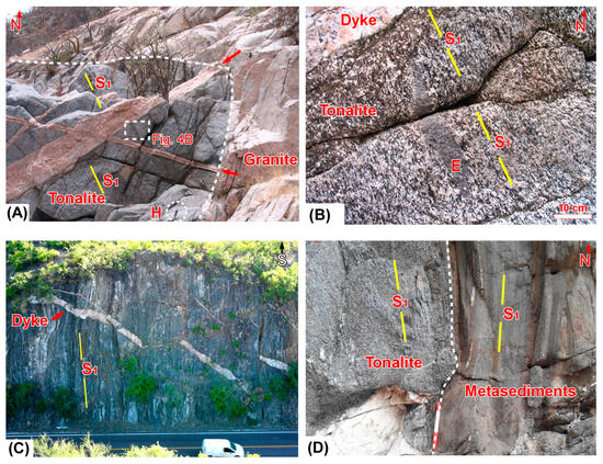
Figure 4.
Outcrops of the Las Cruces intrusive suite units. (A) Intrusive contact between tonalite and granite, with cross-cutting late magmatic dikes; S1, foliation, H, hammer for scale. (B) Intrusive relationships between late magmatic dykes and magmatic foliation in tonalite; E, enclave. (C) Outcrop of the metasedimentary screen with sub-vertical foliation cross-cut by late magmatic dykes. (D) Intrusive contact between tonalite and metasedimentary, with parallel magmatic and metamorphic foliation.
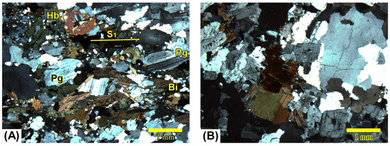
Figure 5.
Petrographic textures of intrusive rocks from the studied area. (A) Magmatic foliation in tonalite, defined by preferential lineament of hornblende (Hb), biotite (Bi), and plagioclase (Pg) crystals; [28]. (B) Non-foliated granite.
4.2. Petrographic Characteristics
Petrographically, the tonalite unit shows magmatic foliation [35], defined by the subparallel alignment of euhedral biotite and hornblende crystals and denoted by plagioclase twins (Figure 5A). Late magmatic dikes with pegmatitic texture and granitic composition constitute the youngest unit of the LCIS. Petrographically, the dikes are dominated by plagioclase, potassium feldspar, biotite, and quartz, with lesser amounts of muscovite, tourmaline, and almandine garnet. They exhibit a textural variation from pegmatite in the center to aplite at the edges. Their thickness ranges from 2 m to a few centimeters, and they generally have a subhorizontal attitude. The dikes intrude all other units of the LCIS and are more abundant at the edges of the Las Cruces granite. At these locations, it is possible to observe that the dikes cut discordantly across the foliation of the metasedimentary screens and tonalite, as well as the intrusive contacts (Figure 4A,B). The El Cajoncito Creek provided field evidence that the pegmatitic dikes originated from the granite, causing an auto intrusion effect near the contact with the tonalite.
4.3. U-Pb Ages in Zircons
The analyzed samples include tonalites, a diorite enclave, and granites, with textures ranging from coarse to very coarse. The zircons concentrated from the five samples exhibit well-developed crystallographic shapes with defined facets, characteristic of igneous zircons [38]. The five dated samples yielded Cretaceous ages. Calculated ages indicate a normal typical crystallization sequence, with older ages for tonalitic edges and younger for the granitic core (Table 1). The three samples corresponding to the edges (tonalites and diorite) are the oldest. They are consistent with each other, implying a crystallization age during the Cretaceous between 103.5 ± 1.5 and 96.0 ± 0.6 Ma (Figure 6, Figure 7 and Figure 8).

Table 1.
Summary of zircon U-Pb ages of the analyzed samples from both sides of the Las Cruces intrusive suite and reported ages from previous authors [20]. Coordinates are in UTM system Zone 12R.
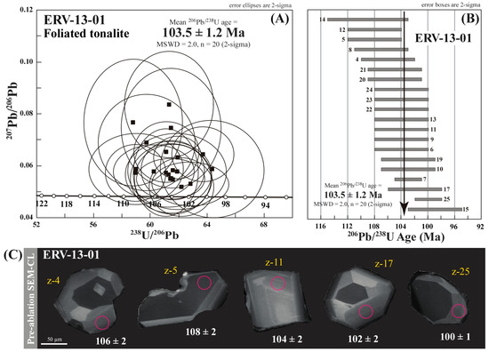
Figure 6.
Zircons U-Pb geochronology results for a sample of tonalite with magmatic foliation (ERV-13-01) from the western side of the LCIS. (A) Concordia age plot showing the analyzed zircon grains, (B) weighted mean age plot, and (C) Cathodoluminescence image of the representative individual zircon grains showing the laser-ablation spot location in pink circles.
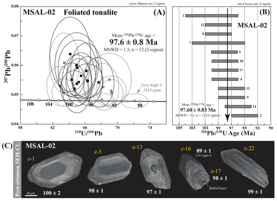
Figure 7.
Zircons U-Pb geochronology results for the sample of tonalite with magmatic foliation (MSAL-02) from the eastern side of the LCIS. (A) Concordia age plot showing the analyzed zircon grains, (B) weighted mean age plot, and (C) Cathodoluminescence image of the representative individual zircon grains.
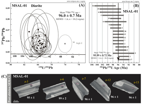
Figure 8.
Zircons U-Pb geochronology results for the diorite sample included as an enclave in tonalite with magmatic foliation (MSAL-01) from the eastern side of the LCIS. (A) Concordia age plot showing the analyzed zircon grains, (B) weighted mean age plot, and (C) Cathodoluminescence image of the representative individual zircon grains.
Conversely, the two granite samples from the suite’s core are younger and consistent with Cretaceous ages, ranging from 95.0 ± 0.9 to 93.6 ± 0.7 Ma (Figure 9 and Figure 10). The U-Pb ages obtained in this study are consistent with the field relationships of the LCIS units, where it is observed that the gabbro is intruded by the tonalite, and the tonalite is, in turn, intruded by the granite. In the regional context, these U-Pb ages are consistent with crystallization ages of 102.3 ± 2.9 and 109.0 ± 2.3 Ma reported for a gabbroic pluton (El Novillo) located to the south of the Sierra Las Cruces [20]. The two gabbroic apophyses found on the western edge of the LCIS can be correlated with a gabbro located to the south of the area (Figure 1).
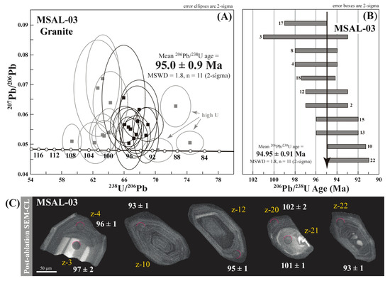
Figure 9.
Zircons U-Pb geochronology results for the granite (MSAL-03) granite (MSAL-03) sample from the western side of the LCIS. (A) Concordia age plot showing the analyzed zircon grains, (B) Weighted mean age plot, and (C) Cathodoluminescence image of the representative individual zircon grains.
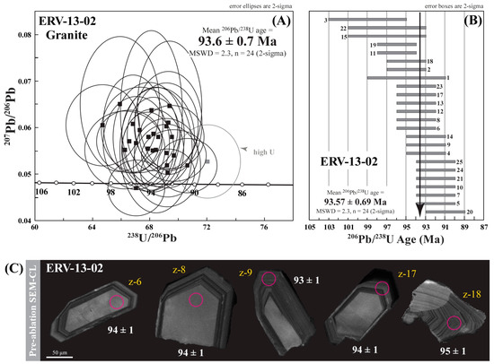
Figure 10.
Zircons U-Pb geochronology results for the granite sample (ERV-13-01) from the western side of the LCIS. (A) Concordia age plot showing the analyzed zircon grains, (B) weighted mean age plot, and (C) Cathodoluminescence image of the representative individual zircon grains.
5. Discussion and Conclusions
The host rocks of the LCIS consist of Cretaceous metasedimentary rocks, primarily composed of biotite schists, hornblende, and calc-silicates, appearing as screens and roof pendants. This implies that this intrusive suite was emplaced in a sedimentary environment, such as the continental margin of the North American craton [3]. The LCIS comprises a central granite pluton, bordered by tonalite, and specifically on the western side, it features two minor isolated outcrops of gabbro. Field relationships and new U-Pb ages obtained in this study indicate a normal magmatic zonation and emplacement for the LCIS, which was between ~109 and 93 Ma. Regarding the predominant tectonics during emplacement and subsequent deformation, two different fabrics were generated and can be identified in the intrusives. These textures are distinguishable in the gabbro and tonalite. One fabric corresponds to a magmatic fabric and the other to a high-temperature tectonic fabric [35]. Magmatic fabric is widely distributed in gabbro and tonalite units and absent in the granite. In the tonalite, this fabric is parallel–subparallel to the intrusive contacts between units and metasedimentary rocks foliation. In the gabbro, the magmatic fabric occurs near the contacts with tonalite. The high-temperature tectonic fabric is only present in the tonalite that cuts through the magmatic fabric, forming discrete ductile shear zones with reverse kinematics. The magmatic fabric suggests that the crystallization and early cooling of the oldest intrusive units (gabbro and tonalite) occurred under compressive conditions. However, the granite was emplaced after compression diminished, based on the lack of magmatic foliation of this unit. After granite emplacement, a relatively rapid cooling from crystallization to temperatures of approximately 180 °C is suggested by a zircon fission-track age of 63 ± 3 Ma [21]. Furthermore, the LCIS resided at the surface during the Oligocene since sedimentary and volcano-sedimentary rocks dated via 40Ar/39Ar in sanidine in 30.6 ± 4 Ma discordantly overlie the granite [30]. These cooling and volcanic rock ages can be associated with the exhumation of the intrusives linked to the compression generated at the westward-subducting plate. This interpretation has been suggested for the northern part of the Baja California Peninsula [39]. Previous interpretation of the western edge of the LCIS involved the assumption of a fault-related tectonic boundary between tonalite and granite based on the presence of a structural lineament with foliated tonalite oriented parallel to it [24]. The previously inferred La Paz Fault was revisited in the field in this study. Our field observations show that this lineament corresponds to an intrusive contact between the tonalite and the granite, and the foliation in the tonalite is magmatic, generated during the crystallization of this unit. Furthermore, this contact between the tonalite with magmatic foliation and the granite is also cross-cut by late magmatic dykes. Neither the contact nor the dikes show evidence of tectonic deformation during or after the intrusive suite emplacement (Figure 4A). Therefore, the presence of this La Paz fault and its influence on the local tectonic evolution can be neglected, based on the detailed fieldwork and structural analysis. The new zircon U-Pb crystallization ages reported in this study are consistent with reported crystallization ages of 100.2 and 103.2 Ma from intrusives located at the southern end (latitude 28°N) of the Peninsular Ranges batholith [11,18]. These U-Pb ages, combined with the geochemical and geophysical data from the LCBC reported by previous studies [16,18,20], support the correlation with the PRB. The continuation of the PRB in the southern Baja California Peninsula is interrupted by a cover of Neogene volcano-sedimentary rocks. Data generated shed light on this long-lasting misinterpretation of a discontinuous but contemporaneous magmatic evolution along the PRB. We can suggest that the PRB represents a continuous magmatic belt along the Baja California Peninsula.
Supplementary Materials
The following supporting information can be downloaded at https://www.mdpi.com/article/10.3390/geosciences14120322/s1, Table S1: U-Th-Pb analytical data for LA-ICPMS spot analyses on zircon grains from Las Cruces intrusive suite units, Baja California Sur, Mexico.
Author Contributions
Conceptualization, E.R.-V. and R.E.L.-Z.; methodology, E.R.-V.; software, E.R.-V.; validation, M.A.I.-L. and J.W.; formal analysis, E.R.-V.; investigation, E.R.-V. and R.E.L.-Z.; resources, E.R.-V., R.E.L.-Z. and J.W.; data curation, E.R.-V. and R.E.L.-Z.; writing—original draft preparation, E.R.-V.; writing—review and editing. E.R.-V. and T.I.G.R.; visualization, R.E.L.-Z. and T.I.G.R.; supervision, M.A.I.-L. and J.W.; project administration, E.R.-V.; funding acquisition, E.R.-V., R.E.L.-Z., M.A.I.-L. and J.W. All authors have read and agreed to the published version of the manuscript.
Funding
This research received partial financial support from the Mexican Sudcalifornian Council for Science and Technology (COSCyT) under the project CAR/15/2023, titled: Evaluation of Recharge in the Novillo Area, the Main Recharge Zone of the La Paz Aquifer; and Identification of the Factors and Processes Influencing Recharge. This research also received partial financial support from FICEN of the University of Sonora under the Project USO315007382, titled: Estudio termocronológico del microgranito miocénico en la Sierra El Aguaje, Sonora, México: significado geodinámico en la Provincia Extensional del Golfo de California.
Data Availability Statement
Data is contained within the article or Supplementary Materials.
Acknowledgments
The authors are grateful to Herman Cota Lau and other students from the Earth Sciences Department of the Universidad Autónoma de Baja California Sur for their support during the fieldwork.
Conflicts of Interest
The authors declare no conflicts of interest.
References
- Gastil, G. Mesozoic and Cenozoic granitic rocks of southern California and western Mexico. In Circum Pacific Plutonic Terranes; Roddick, J.A., Ed.; Geological Society of America Memoir: Boulder, CO, USA, 1983; Volume 159, pp. 265–275. [Google Scholar]
- Silver, L.T.; Chappell, B.W. The Peninsular Ranges batholith: An insight into the Cordilleran batholiths of southwestern North America. Trans. Roy. Soc. Edinb. 1988, 79, 105–121. [Google Scholar] [CrossRef]
- Busby, C. Continental growth at convergent margins facing large ocean basins: A case study from Mesozoic convergent-margin basins of Baja California, Mexico. Tectonophysics 2004, 392, 241–277. [Google Scholar] [CrossRef]
- Ortega-Gutiérrez, F.; Elías-Herrera, M.; Morán-Zenteno, D.; Solari, L.A.; Luna-Gonzalez, L.; Schaaf, P. A review of batholiths and other plutonic intrusions of Mexico. Gondwana Res. 2014, 26, 834–868. [Google Scholar] [CrossRef]
- Valencia-Moreno, M.; Ortega-Rivera, A. Cretácico Tardío-Eoceno Medio en el noroeste de México—Evolución del arco magmático continental y su contexto geodinámico (orogenia Laramide). In Panorama de la Geología de Sonora, México; Calmus, T., Ed.; Universidad Nacional Autónoma de México, Instituto de Geología: Ciudad de México, México, 2011; Boletín 118, Caption 6; pp. 201–226. [Google Scholar]
- Walawander, M.J.; Gastil, R.G.; Clinkenbeard, J.P.; McCormick, W.V.; Eastman, B.G.; Wernicke, R.S.; Wardlaw, M.S.; Gunn, S.H.; Smith, B.M. Origin and evolution of the zoned La Posta-type plutons, eastern Peninsular Ranges batholith, southern and Baja California. In The Nature and Origin of Cordilleran Magmatism; Anderson, J.L., Ed.; Geological Society of America Memoir: Boulder, CO, USA, 1990; Volume 174, pp. 1–18. [Google Scholar]
- Tate, M.C.; Johnson, S.E. Origins of voluminous tonalite in the Mexican Peninsular Ranges and other Cordilleran batholiths. J. Geol. 2000, 108, 721–728. [Google Scholar] [CrossRef]
- Schmidt, K.L.; Paterson, S.R. A doubly vergent fan structure in the Peninsular Ranges batholith: Transpression or local complex flow around a continental margin buttress? Tectonics 2002, 21, 14-1–14-19. [Google Scholar] [CrossRef]
- Johnson, S.E.; Fletcher, J.M.; Fanning, C.M.; Vernond, R.H.; Paterson, S.R.; Tate, M.C. Structure, emplacement and lateral expansion of the San José tonalite pluton, Peninsular Ranges batholith, Baja California, México. J. Struct. Geol. 2003, 25, 1933–1957. [Google Scholar] [CrossRef]
- Ortega-Rivera, A. Geochronological constraints on the tectonic history of the Peninsular Ranges batholith of Alta and Baja California: Tectonic implications for western México. Geol. Soc. Am. 2003, 374, 297–335. [Google Scholar]
- Le Pera, E.; Tangari, A.C.; Marinangeli, L.; Morrone, C.; Riber, R.; Andò, S. Provenance of modern sands from Baja California rivers (Mexico): Petrographic constraints from light and heavy minerals. J. Sediment. Res. 2023, 93, 617–641. [Google Scholar] [CrossRef]
- Marsaglia, K.M.; Barone, M.; Critelli, S.; Busby, C.; Fackler-Adams, B. Petrography of volcaniclastic rocks in intra-arc volcano-bounded to fault-bounded basins of the Rosario segment of the Lower Cretaceous Alisitos oceanic arc, Baja California, Mexico. Sediment. Geol. 2016, 336, 138–146. [Google Scholar] [CrossRef]
- Kimbrough, D.L.; Smith, D.P.; Mahoney, J.B.; Moore, T.E.; Gastil, R.G.; Ortega-Rivera, A.; Fanning, C.M. Forearc basin sedimentary response to rapid Late Cretaceous batholith emplacement in the Peninsular Ranges of southern and Baja California. Geology 2001, 29, 491–494. [Google Scholar] [CrossRef]
- Umhoefer, P.; Dorsey, R.; Willsey, S.; Mayer, L.; Renne, P. Stratigraphy and geochronology of the Comondú Group near Loreto, Baja California Sur, Mexico. Sediment. Geol. 2001, 144, 125–147. [Google Scholar] [CrossRef]
- USGS Publications Wharehouse. Available online: https://pubs.usgs.gov/publication/mf2000 (accessed on 16 September 2024).
- Drake, W.R.; Umhoefer, P.J.; Griffiths, A.; Vlad, A.; Peters, L.; McIntosh, W. Tectono-stratigraphic evolution of the Comondú Group from Bahía de La Paz to Loreto, Baja California Sur, Mexico. Tectonophysics 2017, 719–720, 107–134. [Google Scholar] [CrossRef]
- Gastil, G.R.; Phillips, R.P.; Allison, E.C. Reconnaissance Geology of the State of Baja California; Geological Society of America: Boulder, CO, USA, 1975; Volume 140. [Google Scholar]
- Langenheim, V.S.; Jachens, R.C. Crustal structure of the Peninsular Ranges batholith from magnetic data: Implications for the Gulf of California rifting. Geoph. Res. Lett. 2003, 30, 51-1–51-4. [Google Scholar] [CrossRef]
- Kimbrough, D.L.; Grove, M. The eastern Peninsular Ranges batholith magmatic flare-up: Insight from zircon U-Pb ages and oxygen isotope ratios. In Proceedings of the Geological Society of America Abstracts with Programs, Specialty Meeting, Backbone of the Americas—Patagonia to Alaska, Mendoza, Argentina, 7 April 2006. [Google Scholar]
- Kimbrough, D.; Grove, M.; Morton, D. Timing and significance of gabbro emplacement within two distinct plutonic domains of the Peninsular Ranges batholith, southern and Baja California. Geol. Soc. Am. Bull. 2014, 127, 19–37. [Google Scholar] [CrossRef]
- Fletcher, J.M.; Khon, B.P.; Foster, D.A.; Gleadow, A.J.W. Heterogeneous Neogene cooling and exhumation of the Los Cabos block, southern Baja California: Evidence from fission tracks thermochronology. Geology 2000, 28, 107–110. [Google Scholar] [CrossRef]
- Schaaf, P.; Böhnel, H.; Pérez-Venzor, J.A. Pre-Miocene palaeogeography of the Los Cabos Block, Baja California Sur: Geochronological and palaeomagnetic constraints. Tectonophysics 2000, 318, 53–69. [Google Scholar] [CrossRef]
- Pérez Venzor, J.J. Estudio Geológico-Geoquímico del Borde Oriental del Bloque de Los Cabos, Baja California Sur, México. Ph. D. Thesis, Universidad Nacional Autónoma de México, Ciudad de México, México, 2013. [Google Scholar]
- Hausback, B. Cenozoic volcanic and tectonic evolution of Baja California Sur, Mexico. In Geology of the Baja California Peninsula; Frizell, V.A., Jr., Ed.; S.E.P.M., Pacific Section: Fullerton, CA, USA, 1984; Volume 39, pp. 219–236. [Google Scholar]
- Ramos Velázquez, E. Características de la deformación en las rocas cristalinas cretácicas de la región E-SE de la ciudad de La Paz, B.C.S., México. Master’s Thesis, Centro de Investigación y Educación Superior de Ensenada, Ensenada, México, 1998. Available online: http://cicese.repositorioinstitucional.mx/jspui/handle/1007/2940 (accessed on 22 November 2024).
- Aranda Gómez, J.J.; Pérez Venzor, J.A. Estudio geológico de Punta Coyotes, Baja California Sur. Rev. Mex. Cienc. Geológicas 1988, 7, 1–21. [Google Scholar]
- Vernon, R. Review of Microstructural Evidence of Magmatic and Solid-State Flow. Vis. Geosci. 2000, 5, 1–23. [Google Scholar] [CrossRef]
- Paterson, S.R.; Vernon, R.H.; Tobisch, O.T. A review of criteria for identification of magmatic and tectonic foliations in granitoids. J. Struct. Geol. 1989, 11, 349–363. [Google Scholar] [CrossRef]
- Paterson, S.R.; Fowler, T.K.; Schmidt, K.L.; Yoshinobu, A.S.; Yuan, E.S.; Miller, R.B. Interpreting magmatic fabric patterns in plutons. Lithos 1998, 44, 53–82. [Google Scholar] [CrossRef]
- Carta Geológico-Minera La Paz, G12-10-11 Baja California Sur. Available online: https://mapserver.sgm.gob.mx/Cartas_Online/metadatos_geol/23_GL_la_paz.html (accessed on 16 September 2024).
- Severson, A.R. Shear-Zone Hosted Gold and Silver Deposits in the Sierra Cacachilas, Baja California Sur, Mexico. Master’s Thesis, Arizona State University, Tempe, AZ, USA, 2015. Available online: https://hdl.handle.net/2286/R.I.34810 (accessed on 22 November 2024).
- Coyan, M.M.; Arrowsmith, J.R.; Umhoefer, P.; Coyan, J.; Kent, G.; Driscoll, N.; Gutierrez, G.M. Geometry and Quaternary slip behavior of the San Juan de los Planes and Saltito fault zones, Baja California Sur, Mexico: Characterization of rift-margin normal faults. Geosphere 2013, 9, 426–443. [Google Scholar] [CrossRef]
- Puy-Alquiza, M.J.; Miranda-Avilés, R.; López-Martínez, M. Revisión estratigráfica de Punta Coyote (Baja California Sur, México) e implicaciones para el volcanismo de la Sierra Madre Occidental y el arco Comondú. Estud. Geológicos 2010, 66, 193–208. [Google Scholar] [CrossRef]
- Solari, L.A.; Gómez-Tuena, A.; Bernal, J.P.; Pérez-Arvizu, O.; Tanner, M. U-Pb zircon geochronology by an integrated LA-ICPMS microanalytical workstation: Achievements in precision and accuracy. Geostand. Geoanalytical Res. 2010, 34, 5–18. [Google Scholar] [CrossRef]
- González-León, C.M.; Solari, L.; Valencia-Moreno, M.; Rascon-Heimplel, M.A.; Solé, J.; González-Becuar, E.; Lozano-Santacruz, R.; Pérez-Arvizu, O. Late Cretaceous to early Eocene magmatic evolution of the Laramide arc in the Nacozari quadrangle, northeastern Sonora, Mexico and its regional implications. Ore Geol. Rev. 2016, 81, 1137–1157. [Google Scholar] [CrossRef]
- Ludwig, K.R. User’s Manual for Isoplot/EX, Version 3.00. In A Geochronological Toolkit for Microsoft Excel; Berkeley Geochronology Center, Special Publication: Berkeley, CA, USA, 2003; Volume 4, 70p. [Google Scholar]
- Paton, C.; Hellstrom, J.; Paul, B.; Woodhead, J.; Hergt, J. Iolite: Freeware for the visualisation and processing of mass spectrometric data. J. Anal. At. Spectrom. 2011, 26, 2508. [Google Scholar] [CrossRef]
- Pupin, J.P. Zircon and granite petrology. Contrib. Mineral. Petrol. 1980, 73, 207–220. [Google Scholar] [CrossRef]
- Sláma, J.; Košler, J.; Condon, D.J.; Crowley, J.L.; Gerdes, A.; Hanchar, J.M.; Horstwood, M.S.A.; Morris, G.A.; Nasdala, L.; Norberg, N.; et al. Plešovice zircon—A new natural reference material for U–Pb and Hf isotopic microanalysis. Chem. Geol. 2008, 249, 1–35. [Google Scholar] [CrossRef]
Disclaimer/Publisher’s Note: The statements, opinions and data contained in all publications are solely those of the individual author(s) and contributor(s) and not of MDPI and/or the editor(s). MDPI and/or the editor(s) disclaim responsibility for any injury to people or property resulting from any ideas, methods, instructions or products referred to in the content. |
© 2024 by the authors. Licensee MDPI, Basel, Switzerland. This article is an open access article distributed under the terms and conditions of the Creative Commons Attribution (CC BY) license (https://creativecommons.org/licenses/by/4.0/).