Article

The Evaluation of Rainfall Warning Thresholds for Shallow Slope Stability Based on the Local Safety Factor Theory

1
Department of Resources Engineering, National Cheng Kung University, Tainan 701, Taiwan
2
Advanced Geological Research Task Force, Sinotech Engineering Consultants, Inc., Taipei 114, Taiwan
*
Author to whom correspondence should be addressed.
Geosciences 2024, 14(10), 274; https://doi.org/10.3390/geosciences14100274
Submission received: 12 September 2024 / Revised: 8 October 2024 / Accepted: 15 October 2024 / Published: 16 October 2024
(This article belongs to the Special Issue Landslide Monitoring and Mapping II)

Abstract

:
Rainfall-induced shallow slope instability is a significant global hazard, often triggered by water infiltration that affects soil stability and involves dynamic changes in the hydraulic behavior of unsaturated soils. This study employs a hydro-mechanical coupled analysis model to assess the impact of rainfall on slope stability, focusing on the dynamic hydraulic behavior of unsaturated soils. By simulating the soil water content and slope stability under four different rainfall scenarios based on observational data and historical thresholds, this study reveals that higher rainfall intensity significantly increases the soil water content, leading to reduced slope stability. The results show a strong correlation between the soil water content and slope stability, with a 20 mm/h rainfall intensity threshold emerging as a reliable predictor of potential slope instability. This study contributes to a deeper understanding of slope stability dynamics and emphasizes the importance of proactive risk management in response to changing rainfall patterns while also validating current management practices and providing essential insight for improving early warning systems to effectively mitigate landslide risk.

1. Introduction

Rainfall-induced shallow slope failures are a widespread hazard globally [1,2,3]. These failures typically start with localized instabilities within the slope, which are driven by water movement, storage, and pressure buildup [4,5]. When rainfall infiltrates unsaturated soils, it leads to changes in soil water content and a reduction in shear strength, making slopes more prone to instability [6,7]. Ivanov et al. [8], based on laboratory experiments, pointed out that the coupled interaction of rainfall intensity, hydraulic conductivity, and soil water content gradient governs the stability of slope soils. Additionally, soil water dynamics play a crucial role in the development of the soil wetting front and the initiation of slope instability. The redistribution of soil water, influenced by rainfall intensity, infiltration rates, soil structure, and other properties, plays a key role in triggering these failures, and understanding these processes is essential for effective slope stability management [9,10].
Globally, various mitigation strategies have been implemented to reduce the risk of rainfall-induced shallow landslides [11,12,13]. These include the installation of drainage systems to manage excess water and prevent pore pressure buildup [14,15], the use of retaining walls and reinforced soil structures to provide mechanical stabilization [16], and vegetative cover to reduce surface runoff and enhance soil cohesion [17]. Furthermore, early warning systems, based on rainfall thresholds and slope monitoring techniques, have been developed in several countries to predict landslides and minimize their impact on communities [18,19,20,21,22,23]. Despite these efforts, challenges remain, particularly in accurately predicting slope failures under extreme weather conditions and in complex terrains.
To assess rainfall-induced shallow landslides, two primary methods are commonly used: empirical rainfall thresholds and physically based models. Empirical rainfall thresholds rely on historical data to establish specific rainfall conditions that, when reached or exceeded, are likely to trigger slope failures [24,25,26,27,28,29]. This approach uses observed relationships between rainfall and landslides to predict potential instability based on past events. While rainfall threshold-based predictions are cost-effective and extensively employed in landslide early warning systems (LEWS) [30], their effectiveness can diminish when applied to site-specific forecasts, as rainfall acts as an indirect indicator of slope instability [31]. Moreover, such thresholds do not consider the unsaturated/saturated flow processes and the hydrological conditions of the soil at the onset of specific rainfall events. To address these limitations, some studies have proposed physically based models to estimate rainfall thresholds by integrating hydrological modeling with stability analysis [9,32,33,34,35,36,37]. Physically based models simulate the hydrological processes of rainfall infiltration and its impact on slope stability [38,39,40,41]. These models can consider the spatial distribution of rainfall, its interaction with both soil and terrain, and the mechanical consequences that arise for slope stability. Moreover, they incorporate soil spatial variability, a critical factor that significantly influences the reliability of geotechnical structure and the accurate characterization of soil parameters [42]. By linking hydrological processes with slope stability analysis, these models provide a more comprehensive understanding of shallow landslide dynamics. While they enhance predictive precision through detailed simulations of rainfall infiltration and its effects on slope stability, there is considerable potential for further refinement. For instance, incorporating soil–plant–biochar interaction into these models could lead to improved prediction [43,44]. These interactions can influence soil hydraulic properties, like water retention, providing additional insights into how extreme rainfall events impact slope stability.
Traditional slope stability analysis mainly relies on Limit Equilibrium Analysis (LEA). This method involves discretizing the potential failure surface into smaller vertical slices based on force and moment balance concepts, using the factor of safety (FS) to represent slope stability. Various analytical methods, such as those developed by Fellenius [45], Janbu [46], Bishop [47], and Morgentern and Price [48], are based on different equilibrium assumptions. However, these force–balance methods typically provide a single stability indicator and are limited in identifying variations in pore water pressure and effective stress caused by rainfall infiltration, as well as the temporal and spatial changes in slope stability. In recent years, the finite element method (FEM) has been widely applied to analyze slope stability, especially for complex slopes with intricate geometries, boundary conditions, or loading scenarios. FEM considers the stress–strain relationship of soil, offering a more comprehensive assessment of slope stability [49,50,51,52,53,54,55,56,57].
Rainfall-induced changes in a slope’s internal hydrological behavior are crucial for assessing slope failure risks [58,59]. Understanding soil hydromechanical behavior is crucial for accurate slope stability analysis, as these mechanisms directly influence the likelihood of slope failure during rainfall events. The Soil Water Characteristic Curve (SWCC) is crucial for analyzing the hydrological and mechanical behavior of unsaturated soils by defining the relationship between matric suction and water content [60,61]. For unsaturated soil mechanics, Lu and Likos [62] unified the various physical and chemical mechanisms occurring between soil particles and introduced the concept of suction stress. They later developed the Suction Stress Characteristic Curve (SSCC) to describe the changes in stress between soil particles under varying water content conditions [63]. Oh et al. [64] and Lu et al. [65] showed that variations in the stress state of unsaturated soils can be described by changes in water content or matric suction, validating the intrinsic relationship between the SWCC and SSCC. Subsequently, Lu et al. [66] proposed the Local Factor of Safety (LFS) based on the Mohr–Coulomb failure criterion, which effectively describes the geometry and location of potential failure surfaces, overcoming challenges inherent in traditional slope stability analysis.
This study employs a hydro-mechanical coupled analysis model and local factor of safety theory to evaluate the local factor of safety at various depths of shallow slopes. It explores the impact of rainfall on the internal hydrological behavior and stability of shallow slopes, aiming to enhance the effectiveness of early warning systems for rainfall-induced shallow landslides.

2. Materials and Methods

2.1. Study Area Description

The study area is the Babaoliao landslide located in Dongxing Village, Zhongpu Township, Chiayi County, Taiwan, as depicted in Figure 1. The village, with a population of about 350 people, relies on agriculture, mainly growing bamboo, citrus fruits, and betel nuts on the hillside. The annual rainfall in the study area ranges from approximately 1755 to 3209 mm, with the rainy season concentrated from April to September each year. This region features hilly terrain with elevations ranging from 420 to 580 m and slope angles generally exceeding 40°. Most of the slopes face south, with others oriented southeast, southwest, and west. The initial landslide event in this area occurred in November 2011, exacerbated by heavy rainfall and typhoons, leading to an expansion of the landslide-affected area to approximately 11.31 hectares. The landslide displays characteristics of both shallow–rapid failure and deep-seated slope deformation. The area is part of the western foothill geological zone, with Miocene to Pleistocene-aged sandstone and shale. The dense distribution of geological structures, including prominent synclines and anticlines, contributes to the region’s rugged and steep terrain. Rainfall infiltration into the shallow soil and the development of preferential flow along the slip plane may lead to slope instability.
Based on high-precision 2016 LiDAR survey data, 26 scarp features were identified within the Babaoliao landslide area, delineating 26 associated small sliding blocks through their arcuate distributions. These features, along with watershed boundary analysis, led to the division of the landslide into five zones, as shown in Figure 1. Among these, zone A (yellow) and D (blue) are particularly notable for their expanding sliding bodies following rainfall, exhibiting soil translation slides. Zone A, located on the upper slope, is primarily subject to shallow sliding, making it highly susceptible to collapse or landslides under rainfall influence. In zone D, significant vegetation retreat toward the ridgeline and the presence of numerous downslope-tilted tree trunks in front of the scarps suggest progressive slope failure. These ongoing movements have resulted in considerable soil loss, negatively impacting local agriculture and infrastructure, and thus necessitate close monitoring. Therefore, this study established monitoring profiles in zone A and zone D, designated as A-A’ and B-B’, as shown in Figure 1.
Soil and bedrock samples were collected from the landslide area in zone A, as shown in Figure 1. Soil samples were obtained using a thin-walled tube sampler to maintain their undisturbed structure, with depths ranging from 0.4 m to 1.6 m. Bedrock samples were extracted through core drilling at approximately 20 m. The dominant soil type on the slopes is sandy lean clay (CL), as classified by the Unified Soil Classification System (ASTM D2487-17). Its texture is primarily fine sand to silt, with significant medium-grained sand content. Permeability tests revealed that the soil’s permeability ranged from 1.64 × 10⁻⁷ to 8.99 × 10⁻⁶ cm/s at 20 °C, depending on sealing pressures. The bedrock samples are mainly muddy sandstone, exhibiting unit weights between 2.37 and 2.69 t/m3, water contents from 1.9% to 8.7%, specific gravities of 2.68 to 2.73, porosities of 0.08 to 0.19, and water absorption rates ranging from 2.7% to 12.8%.
Field monitoring stations, which continuously collect data, are indicated in Figure 1. This study focuses on stations located in zones A and D. Detailed information about the equipment installed at these stations can be found in Table 1. Based on investigations and analyses from Agency of Rural Development and Soil and Water Conservation [67], and using data from an actual landslide event (Tropical Depression rainfall event on 23 August 2018), including internal deformation measurements, cumulative rainfall, rainfall intensity, and groundwater level changes, the following thresholds were established: a cumulative rainfall alert level of 200 mm and a warning level of 300 mm. For rainfall intensity, the alert level is set at 20 mm/h and the warning level at 40 mm/h. Efforts to manage and mitigate the landslide risks are ongoing, but the persistent instability continues to affect local communities and ecosystem.

2.2. Local Factor of Safety

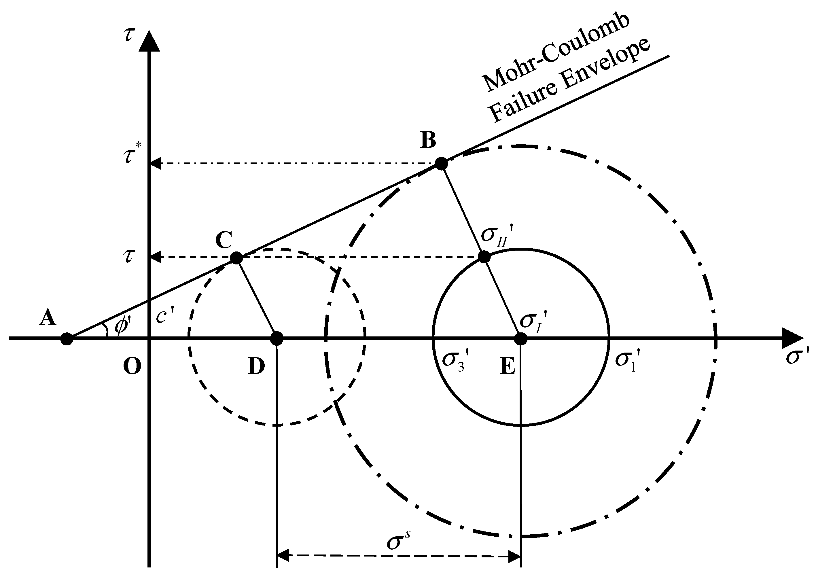
The Local Factor of Safety (LFS) is a metric used to evaluate the stability of slopes by comparing the shear strength of the soil to the actual shear stress at a given point. This concept, based on the Mohr–Coulomb failure criterion, describes the process of stress state changes toward failure in soil due to rainfall [66]. According to this theory, the current stress state of the soil is represented by a Mohr circle, which indicates the shear stress and normal stress at a point. As rainfall increases soil water content, effective stress decreases, causing the Mohr circle to shift leftward. The size of the Mohr circle remains largely unchanged during this shift, as it is primarily influenced by the slope geometry and self-weight of the soil. The strength of the soil can be estimated by the intercept between the Mohr circle and the Mohr–Coulomb failure envelope. This intercept defines the Local Factor of Safety (LFS), representing the ratio of shear strength τ * to shear stress τ at any point within the slope, as illustrated in Figure 2. Therefore, the Local Factor of Safety (LFS) for any point can be derived from the similarity of triangles ACD and ABE, illustrating that the LFS assessment is applicable beyond just circular failure surfaces and can accommodate various slope geometries.
L F S = τ * τ = cos ϕ ' σ I I ' c ' + σ I ' t a n ϕ '
where σ I ' and σ I I ' represent the center and radius of the Mohr circle in two-dimensional space and can be defined as follows:
σ I ' = σ 1 ' + σ 3 ' 2 = σ 1 + σ 3 2 σ s
σ I I ' = σ 1 ' σ 3 ' 2 = σ 1 σ 3 2
where σ 1 and σ 3 are the major and minor principle stresses [ML−1T−2], while σ 1 ' and σ 3 ' are the generalized effective stresses defined by suction stress σ s of variably saturated soil [ML−1T−2], expressed as σ 1 ' = σ 1 u a σ s and σ 3 ' = σ 3 u a σ s [62,63], where u a is the prevailing air pressure [ML−1T−2]. Lu et al. [69], based on thermodynamic theory, conceptualized suction stress as the energy stored within a unit volume of soil. They derived the Suction Stress Characteristic Curve (SSCC) from the Soil Water Characteristic Curve (SWCC), expressed as follows:
σ s = u a u w 1 1 + α u a u w n m
where u a represents the air pressure, and u w denotes the pore water pressure. α , n , and m are the fitting parameters of the Soil Water Characteristic Curve model [70].

2.3. Coupled Hydro-Mechanical Framework

This study uses the finite element analysis model HYDRUS-2D along with the Slope Cube Module to compute one-way coupled variably saturated flow and stress problems. By simulating variably saturated flow—a process characterized by fluctuations in soil water content due to rainfall—and the associated mechanical stresses, we gain insights into how these factors may contribute to potential slope failures. The stability of the slopes is evaluated using the Local Factor of Safety (LFS) derived from these simulations. The model, developed and validated by Lu et al. [71], follows the analysis process shown in Figure 3. Through the transient unsaturated flow solution, the changes in soil water content, suction head, and moist unit weight over time are determined. The two-dimensional flow control equation, based on Richards’ equation [72], is expressed as a transient unsaturated flow solution developed by Šimůnek et al. [73] and is represented as follows:
θ ( h ) t = K ( h ) H + W
where t is time [T], h represents suction head [L], H is total head [L], and W is sources and sink [L3T−1]. K h is the Hydraulic Conductivity Function (HCF) [LT−1], and θ h represents the volumetric water content in the Soil Water Characteristic Curve (SWCC) [L3L−3]. This study adopts the closed-form solution proposed by van Genuchten [70] to predict the relationship between soil water content and changes in matric suction. Based on the Soil Water Characteristic Curve (SWCC), Mualem [74] developed the Hydraulic Conductivity Function (HCF) for unsaturated soils, which is expressed as follows:
θ h = θ r + θ s θ r [ 1 + ( α | h | ) n ] m
K h = K s S e l 1 1 S e 1 / m m 2
where θ h represents the saturated water content of the soil [L3L−3], θ r denotes the residual water content [L3L−3], h is the suction head [L], and α [L−1] and n [-] are the fitting parameters. K s is the saturated hydraulic conductivity [LT−1]; S e is the equivalent degree of saturation [L3L−3]; l is the soil pore connectivity parameter, commonly assumed to be 0.5; and m can calculated n using the following relationship: m = 1 1 / n .
The Slope Cube Module uses the finite element method FEM2D [75] to compute the stress distribution within a slope based on momentum balance. This approach employs plane stress linear elasticity to simulate the stress variations induced by transient changes in unit weight. According to linear theory, stress and strain are related through Hooke’s Law:
σ i j = 2 G ν 1 2 ν ε k k δ i j + 2 G ε i j
ε k k represents the total strain in a specific direction, δ i j represents the identity tensor, μ is Poisson’s ratio, G is the shear modulus and can be expressed in terms of Young’s modulus E , and G = E / 2 1 + ν . In static equilibrium conditions, the horizontal and vertical momentum balances at any point within the slope can be expressed as follows:
σ i j j + b i = 0
b i is the body force vector that has a non-zero component ρ g in the z-direction, is ρ g referred to as the unit weight of the soil material, ρ represents the density of the variably saturated material, and g denotes the gravitational constant. For the two-dimensional analysis of any point within a slope, the eight variables required for the solution process typically include three total stresses ( σ x x , σ x z , σ z z ), three strains ( σ x x , σ x z , σ z z ), and two displacements ( u x , u z ). Therefore, the governing equations for total stress in a linearly elastic material can be expressed as follows:
σ + γ b = 0
By using the above equations, the combined calculations of water content, suction head, and total stress changes are used to determine suction stress. Finally, the local factor of safety (LFS) is calculated using effective stress and suction stress. This approach, based on a hydro-mechanical framework of linear elasticity, solves for stress and displacement in statically admissible stress fields without resorting to complex elastoplastic theories or considering stress or displacement redistribution after slope failure. Statically admissible stress fields are defined as those satisfying the equilibrium differential equations [76]. Hence, an LFS less than 1 indicates potential failure locations within the slope [66], serving as a useful indicator of potential failure zones.

2.4. Establishment of Conceptual Models

This study established two slope conceptual models, with the locations of monitoring stations and soil sampling sites shown in Figure 1. The A-A’ profile of zone A follows the profile line from BH-10CI to SW-01, BH-05CI, and BH-02, spanning approximately 200 m. The B-B’ profile for zone D extends from the upper part of SW-02 down the slope, covering approximately 100 m.
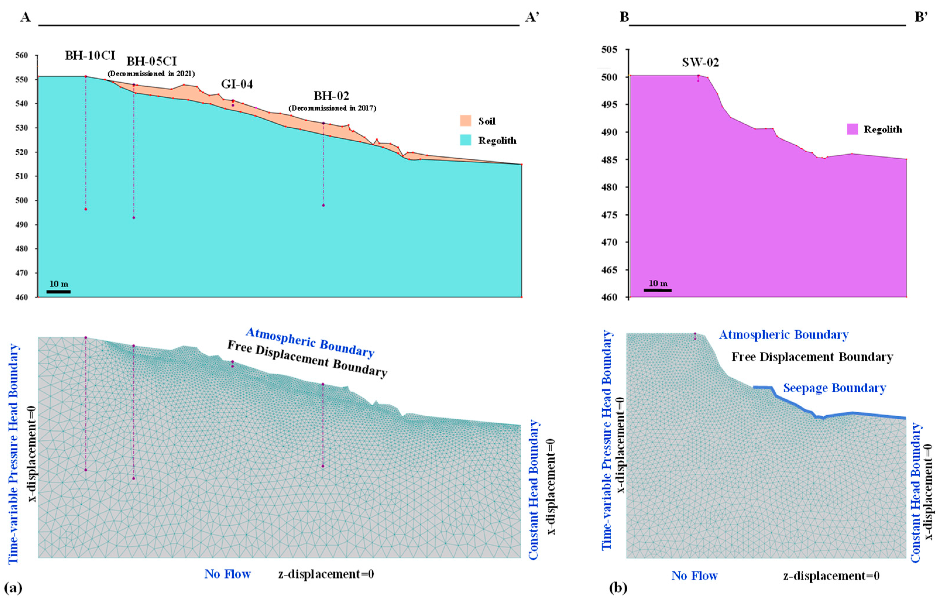
After years of rainfall erosion, the topsoil in zone A has migrated to the lower slope, exposing the bedrock at the top of the slope, as shown in Figure 4a. The profile can be divided into an upper soil layer and a lower bedrock layer. The conceptual model adopts the surface elevation measured on 23 May 2023, applying mesh refinement to the surface layer. The overall mesh consists of 4523 nodes and 9222 elements. The slope surface is set as atmospheric boundary to account for rainfall infiltration and evaporation processes. The right side is designated as a constant head boundary, reflecting stable groundwater levels, while left side is treated as a time-varying head boundary to accommodate dynamic changes in groundwater levels during rainfall events. The bottom boundary is defined as a no-flow boundary, simulating an impermeable layer that prevents water from draining away, thereby maintaining saturation in the soil profile. For the mechanical boundary conditions, the slope surface is designated as a free displacement boundary, allowing for natural soil movement. The left and right side are set zero displacement boundaries in the x-direction, while the bottom is a zero displacement boundary in the z-direction, ensuring stability and preventing unwanted movement of the model base.
For zone D, due to the lack of hydrogeological data, the conceptual model is based on the exposed weathered bedrock, as shown in Figure 4b. Similarly, mesh refinement is applied to the surface layer, resulting in an overall mesh with 2786 nodes and 5570 elements. The hydrological boundary conditions are set as follows: the slope surface is an atmospheric boundary, which facilitates the consideration of rainfall infiltration and evaporation. A seepage boundary is established at a location where seepage was observed, positioned 50 m horizontally from the slope surface. The right side is maintained as a constant head boundary to represent stable groundwater conditions, while the left side is treated as a time-varying head boundary, accommodating fluctuations in groundwater levels associated with rainfall events. Lastly, the bottom boundary is set as a no-flow boundary, simulating an impermeable layer that restricts water movement. The mechanical boundary conditions are similarly structured, with the slope surface treated as a free displacement boundary to permit natural soil movement. The left and right are defined as zero displacement boundaries in the x-direction, and the bottom serves as a zero displacement boundary in the z-direction.
The boundary conditions in this study are primarily based on field observational data. It is important to note that the selection of boundary conditions may affect the model’s accuracy, particularly under intensities and frequencies of rainfall events. The assumption of a time varying head boundary relies on existing monitoring data; however, future changes in hydrological conditions could lead to discrepancies in model predictions. To enhance the model’s reliability, we validated it using field monitoring data, which helps to confirm the consistency between the model’s predictions and actual observed results.
This study used soil hydraulic parameters listed in Table 2, with soil samples collected using thin-walled samplers. The sampling locations are indicated in Figure 1. Hydraulic parameters for the van Genuchten [70] model were obtained using laboratory soil mechanics tests and pressure plate tests. These parameters were used to estimate the Soil Water Characteristic Curve (SWCC) and Hydraulic Conductivity Function (HCF). Subsequently, the Suction Stress Characteristic Curve (SSCC) was calculated using the model developed by Lu [69] to characterize the hydraulic properties of geological materials in the unsaturated zone in the study site.
Due to soil creep in the region, numerous tension cracks and depressions have formed. These cracks may serve as preferential pathways for rainfall infiltration during precipitation events, indicating that the permeability of the surface soil may be higher than that of intact soil. Therefore, this study calibrated hydraulic parameters and hydraulic conductivity to account for these conditions.

3. Results and Discussions

3.1. Model Calibration Analysis

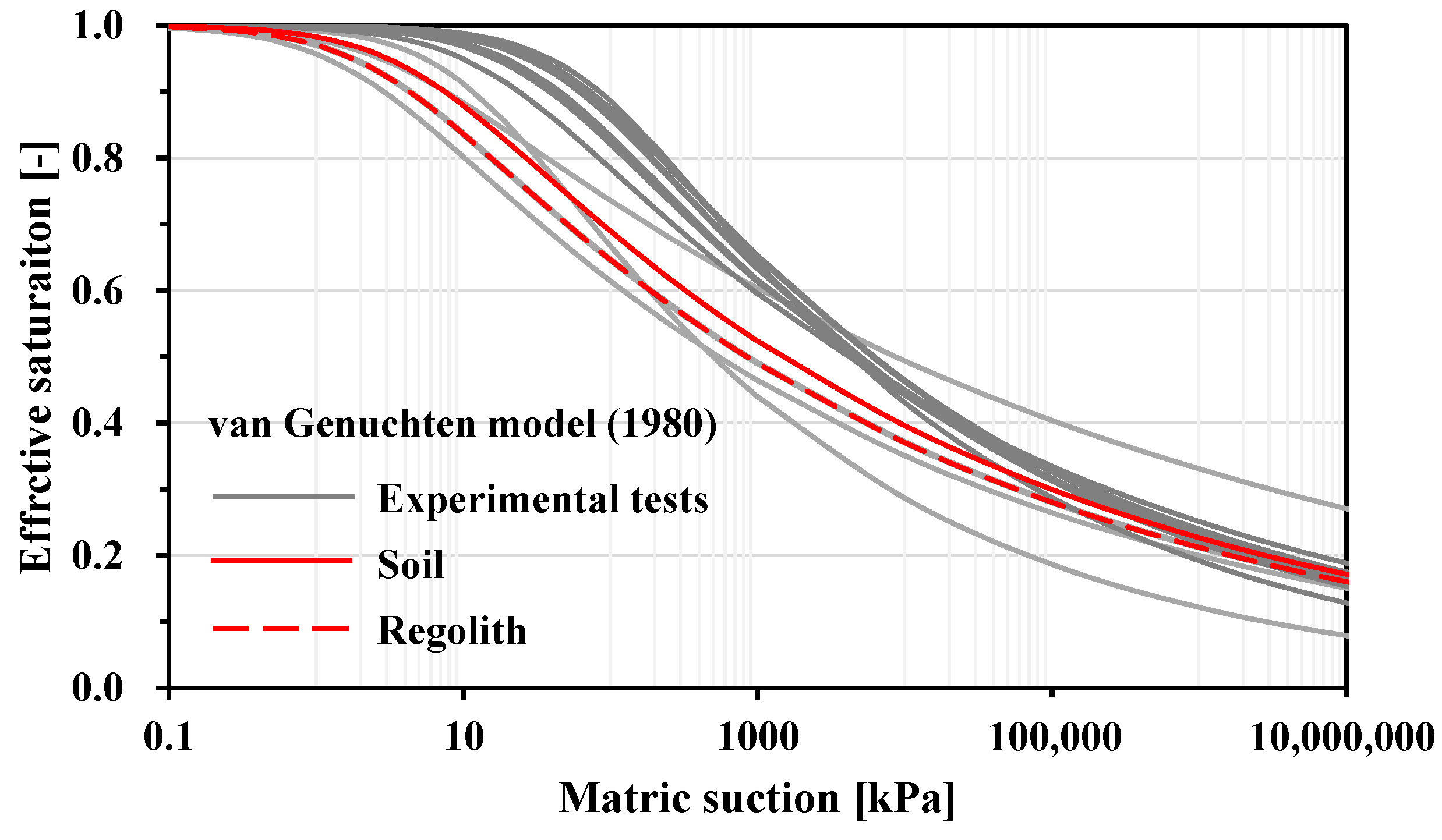
This study selected the 24 h rainfall event on 10 September 2023 (the maximum daily cumulative rainfall of the year) for model calibration and analysis, during which the cumulative rainfall was 276 mm. The convergence criteria for the model iteration were set at an allowable water content tolerance of 0.001 and an allowable pressure head tolerance of 0.1 m. In zone A, model calibration focused on the observed soil water content at a depth of 0.5 m from station SW-01 and the groundwater level at station BH-10CI. The hydrological parameters calibrated were α, n, and Ks. In zone D, calibration was based on the observed soil water content at a depth of 0.5 m from station SW-02. Due to the lack of relevant field and experimental data in this zone, it was considered that the hydraulic conductivity of the weathered surface rock would be superior to that of the intact bedrock. Thus, the material parameters calibrated from zone A were referenced, and further calibration was performed for the Ks value. The calibrated parameter values are shown in Table 2. This study compares the calibrated hydrological parameters with the results of the pressure plate test, as shown in Figure 5. The comparison shows that the calibrated parameters lie within the range of the SWCC derived from experimental data, indicating the validity of the parameters used in the model.
After calibration, the model’s simulation results for groundwater levels and soil water content in zone A show coefficients of determination (R2) of 0.91 and 0.92, respectively, as depicted in Figure 6. The root mean square errors (RMSE) are 0.07 m for groundwater levels and 0.014 for the soil water content. In zone D, the calibrated model yields an R2 of 0.77 for the soil water content, with an RMSE of 0.013. For the given rainfall event, the minimum local factor of safety (LFS) for the two slopes is 1.25 in zone A and 2.15 in zone D.

3.2. Stability Analysis and Simulation of Rainfall Scenarios

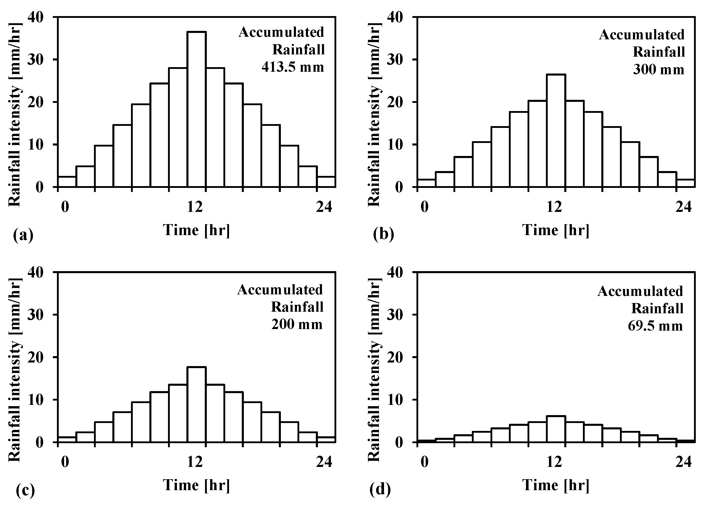
This study collected the maximum daily rainfall data from the rain gauge station for the years 2018 to 2023. During the observation period, the maximum daily cumulative rainfall was 413.5 mm in 2018, while the minimum was 69.5 mm in 2021. The rain gauge management thresholds for the site were set at 200 mm/24 h for alert and 300 mm/24 h for warning [67]. Accordingly, four selected rainfall events are considered as hypothetical scenarios, with rainfall patterns following a 24 h normal distribution, as shown in Figure 7: (a) extreme intensity of 413.5 mm/24 h, (b) high intensity of 350 mm/24 h, (c) moderate intensity of 200 mm/24 h, and (d) low intensity of 69.4 mm/24 h. This study simulates the variations in soil water content and slope stability over time under four different rainfall scenarios. The minimum Local Factor of Safety (LFS) from the calibration scenario is assumed to represent the critical threshold for slope failure, with a critical LFS of 1.25 in zone A and 2.15 in zone D.
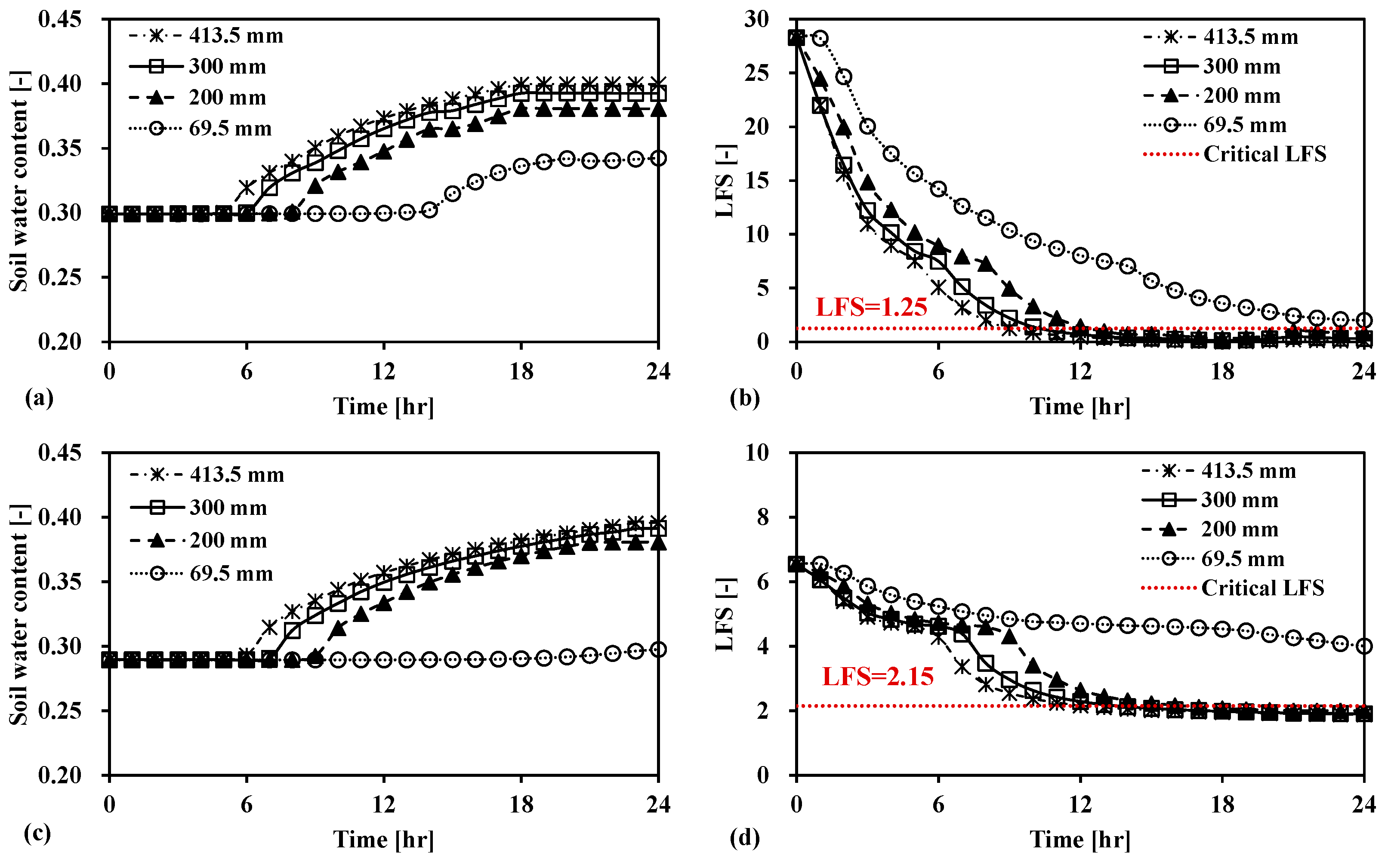
The simulation results at a depth of 0.5 m reveal that both slope areas are highly sensitive to rainfall infiltration, with zone A showing a quicker response. Under the extreme intensity scenario of 413.5 mm/24 h, soil water in zone A responds as early as the 5th hour, with a maximum change of 10.03%, as shown in Figure 8a. In contrast, zone D starts to show a water response at the 6th hour, reaching a maximum change of 10.62%. In the low-intensity scenario of 69.5 mm/24 h, the soil water response in zone D is minimal, with changes of less than 1%, as shown in Figure 8c.
For zone A, under the four rainfall scenarios, the times to slope instability, ordered by decreasing rainfall intensity, are 9, 10.3, and 12.4 h, respectively. Although the lowest cumulative rainfall results in a decrease in stability (with a minimum LFS of 1.99), it does not reach the critical threshold, as shown in Figure 8b. For zone D, the times to slope instability for the different rainfall scenarios, ranked by decreasing intensity, are 12.2, 13.6, and 16.3 h. Despite a minor reduction in stability under the lowest cumulative rainfall (with a minimum LFS of 4.0), the slope remains stable, as depicted in Figure 8d. Additionally, the rainfall patterns for extreme intensity and high intensity show rates exceeding 20 mm/h at the 9th and 10th hours, respectively. This timing aligns with the periods of slope instability observed in the simulations, indicating the appropriateness of using a rainfall intensity threshold of 20 mm/h for the rain gauge management alert levels in the Babaoliao landslide area. This finding can be applied to site-specific landslide risk assessment, aiding decision makers in establishing more accurate warning thresholds, thereby enhancing the effectiveness of landslide monitoring and early warning systems.
However, it is important to note that this study models a specific slope profile and conducts the analysis under a normal rainfall distribution, making the findings highly site-specific. Numerous factors, such as antecedent rainfall, variations in rainfall intensity, and spatial heterogeneity, can impact slope stability assessments. Therefore, it is crucial to continuously evaluate and update the warning thresholds based on comprehensive site-specific monitoring and investigation data. A multifactor approach should be employed to refine warning thresholds, incorporating various influences to improve the reliability and effectiveness of landslide early warning systems for practical application.

4. Conclusions

This study underscores the critical role of soil hydraulic behavior in assessing slope stability, particularly in the context of rainfall-induced shallow landslides. By simulating various rainfall scenarios using calibrated models for the Babaoliao landslide area, the research demonstrates the significant impact of cumulative rainfall and rainfall intensity on slope stability. While the findings reveal a strong correlation between the soil water content and slope stability, with the 20 mm/h rainfall intensity threshold serving as a reliable indicator of potential slope instability, it is essential to recognize the limitation of this study. The model’s applicability may vary across different geological conditions and types of landslides, which warrants caution when generalizing the results beyond the specific study area. Furthermore, this study provides valuable insights into slope stability management and early warning systems. The established rainfall alert thresholds were validated through this study, reinforcing their scientific basis and practical application. By integrating these findings into real-world scenarios, stakeholders can improve the prevention of rainfall-induced landslides. Future research should aim to expand the model’s applicability and explore its effectiveness across diverse geological contexts to enhance landslide-prediction and risk-assessment strategies.

Author Contributions

Conceptualization, Y.-S.Y. and H.-F.Y.; methodology, Y.-S.Y.; software, Y.-S.Y.; validation, L.-W.W. and N.-C.C.; formal analysis, Y.-S.Y., L.-W.W. and N.-C.C.; investigation, L.-W.W.; resources, C.-C.K.; data curation, N.-C.C.; writing—original draft preparation, Y.-S.Y.; writing—review and editing, H.-F.Y.; visualization, Y.-S.Y.; supervision, H.-F.Y.; project administration, H.-F.Y. and C.-C.K. All authors have read and agreed to the published version of the manuscript.

Funding

This research was funded by Soil and Water Conservation Bureau Council, grant number 111LL038 and National Science and Technology Council (NSTC), grant number (113-2625-M-006-012).

Data Availability Statement

The data that support the findings of this study are available from the corresponding author upon reasonable request.

Conflicts of Interest

Authors Chien-Chung Ke, Lun-Wei Wei and Nai-Chin Chen were employed by the company Advanced Geological Research Task Force, Sinotech Engineering Consultants, Inc. The remaining authors declare that the research was conducted in the absence of any commercial or financial relationships that could be construed as a potential conflict of interest..

References

  1. von Ruette, J.; Lehmann, P.; Or, D. Rainfall-triggered shallow landslides at catchment scale: Threshold mechanics-based modeling for abruptness and localization. Water Resour. Res. 2013, 49, 6266–6285. [Google Scholar] [CrossRef]
  2. Emberson, R.; Kirschbaum, D.B.; Amatya, P.; Tanyas, H.; Marc, O. Insights from the topographic characteristics of a large global catalog of rainfall-induced landslide event inventories. Nat. Hazards Earth Syst. Sci. 2022, 22, 1129–1149. [Google Scholar] [CrossRef]
  3. Iverson, R.M. Landslide triggering by rain infiltration. Water Resour. Res. 2000, 36, 1897–1910. [Google Scholar] [CrossRef]
  4. Bogaard, T.A.; Greco, R. Landslide hydrology: From hydrology to pore pressure. Wiley Interdiscip. Rev. Water 2016, 3, 439–459. [Google Scholar] [CrossRef]
  5. Fan, L.; Lehmann, P.; Or, D. Effects of hydromechanical loading history and antecedent soil mechanical damage on shallow landslide triggering. J. Geophys. Res. Earth Surf. 2015, 120, 1990–2015. [Google Scholar] [CrossRef]
  6. Lu, N.; Godt, J. Infinite slope stability under steady unsaturated seepage conditions. Water Resour. Res. 2008, 44, W11404. [Google Scholar] [CrossRef]
  7. Sidle, R.C.; Bogaard, T.A. Dynamic earth system and ecological controls of rainfall-initiated landslides. Earth Sci. Rev. 2016, 159, 275–291. [Google Scholar] [CrossRef]
  8. Ivanov, V.; Arosio, D.; Tresoldi, G.; Hojat, A.; Zanzi, L.; Papini, M.; Longoni, L. Investigation on the role of water for the stability of shallow landslides—Insights from experimental tests. Water 2020, 12, 1203. [Google Scholar] [CrossRef]
  9. Fusco, F.; Bordoni, M.; Tufano, R.; Vivaldi, V.; Meisina, C.; Valentino, R.; Bittelli, M.; De Vita, P. Hydrological regimes in different slope environments and implications on rainfall thresholds triggering shallow landslides. Nat. Hazards 2022, 114, 907–939. [Google Scholar] [CrossRef]
  10. Cai, J.-S.; Yeh, T.-C.J.; Yan, E.-C.; Tang, R.-X.; Hao, Y.-H.; Huang, S.-Y.; Wen, J.-C. Importance of variability in initial soil moisture and rainfalls on slope stability. J. Hydrol. 2019, 571, 265–278. [Google Scholar] [CrossRef]
  11. Amarasinghe, M.P.; Kulathilaka, S.A.S.; Robert, D.J.; Zhou, A.; Jayathissa, H.A.G. Risk assessment and management of rainfall-induced landslides in tropical regions: A review. Nat. Hazards 2024, 120, 2179–2231. [Google Scholar] [CrossRef]
  12. Sultana, N.; Tan, S. Landslide mitigation strategies in southeast Bangladesh: Lessons learned from the institutional responses. Int. J. Disaster Risk Reduct. 2021, 62, 102402. [Google Scholar] [CrossRef]
  13. Kadamb, R.R.; Savoikar, P.P. Rainfall Induced Landslides—A Review, in Recent Developments in Sustainable Infrastructure (ICRDSI-2020)—GEO-TRA-ENV-WRM: Conference Proceedings from ICRDSI-2020 Vol. 2; Das, B.B., Hettiarachchi, H., Sahu, P.K., Nanda, S., Eds.; Springer: Singapore, 2022; pp. 321–331. [Google Scholar]
  14. Arantes, L.T.; Carvalho, A.C.P.; Lorandi, R.; Moschini, L.E.; Di Lollo, J.A. Surface runoff associated with climate change and land use and land cover in southeast region of Brazil. Environ. Chall. 2021, 3, 100054. [Google Scholar] [CrossRef]
  15. Urciuoli, G.; Pirone, M. Subsurface Drainage for Slope Stabilization. In Landslide Science and Practice: Volume 6: Risk Assessment, Management and Mitigation; Margottini, C., Canuti, P., Sassa, K., Eds.; Springer: Berlin/Heidelberg, Germany, 2013; pp. 577–585. [Google Scholar]
  16. Popescu, M.; Commission on Landslide Remediation; International Union of Geological Sciences Working Group on Landslides. A suggested method for reporting landslide remedial measures. Bull. Eng. Geol. Environ. 2001, 60, 69–74. [Google Scholar] [CrossRef]
  17. Masi, E.B.; Segoni, S.; Tofani, V. Root Reinforcement in Slope Stability Models: A Review. Geosciences 2021, 11, 212. [Google Scholar] [CrossRef]
  18. Yang, H.-Q.; Zhang, L.; Gao, L.; Phoon, K.-K.; Wei, X. On the importance of landslide management: Insights from a 32-year database of landslide consequences and rainfall in Hong Kong. Eng. Geol. 2022, 299, 106578. [Google Scholar] [CrossRef]
  19. Kirschbaum, D.; Stanley, T.; Zhou, Y. Spatial and temporal analysis of a global landslide catalog. Geomorphology 2015, 249, 4–15. [Google Scholar] [CrossRef]
  20. Brunetti, M.T.; Peruccacci, S.; Rossi, M.; Luciani, S.; Valigi, D.; Guzzetti, F. Rainfall thresholds for the possible occurrence of landslides in Italy. Nat. Hazards Earth Syst. Sci. 2010, 10, 447–458. [Google Scholar] [CrossRef]
  21. Huang, F.; Chen, J.; Liu, W.; Huang, J.; Hong, H.; Chen, W. Regional rainfall-induced landslide hazard warning based on landslide susceptibility mapping and a critical rainfall threshold. Geomorphology 2022, 408, 108236. [Google Scholar] [CrossRef]
  22. Sala, G.; Lanfranconi, C.; Frattini, P.; Rusconi, G.; Crosta, G.B. Cost-sensitive rainfall thresholds for shallow landslides. Landslides 2021, 18, 2979–2992. [Google Scholar] [CrossRef]
  23. Peruccacci, S.; Gariano, S.L.; Melillo, M.; Solimano, M.; Guzzetti, F.; Brunetti, M.T. The ITAlian rainfall-induced LandslIdes CAtalogue, an extensive and accurate spatio-temporal catalogue of rainfall-induced landslides in Italy. Earth Syst. Sci. Data 2023, 15, 2863–2877. [Google Scholar] [CrossRef]
  24. Huang, J.; Ju, N.P.; Liao, Y.J.; Liu, D.D. Determination of rainfall thresholds for shallow landslides by a probabilistic and empirical method. Nat. Hazards Earth Syst. Sci. 2015, 15, 2715–2723. [Google Scholar] [CrossRef]
  25. Giannecchini, R.; Galanti, Y.; D’Amato Avanzi, G. Critical rainfall thresholds for triggering shallow landslides in the Serchio River Valley (Tuscany, Italy). Nat. Hazards Earth Syst. Sci. 2012, 12, 829–842. [Google Scholar] [CrossRef]
  26. Segoni, S.; Piciullo, L.; Gariano, S.L. Gariano, A review of the recent literature on rainfall thresholds for landslide occurrence. Landslides 2018, 15, 1483–1501. [Google Scholar] [CrossRef]
  27. Caine, N. The rainfall intensity-duration control of shallow landslides and debris flows. Geogr. Ann. 1980, 62, 23–27. [Google Scholar]
  28. Guzzetti, F.; Peruccacci, S.; Rossi, M.; Stark, C.P. Rainfall thresholds for the initiation of landslides in central and southern Europe. Meteorol. Atmos. Phys. 2007, 98, 239–267. [Google Scholar] [CrossRef]
  29. Roccati, A.; Paliaga, G.; Luino, F.; Faccini, F.; Turconi, L. Rainfall Threshold for Shallow Landslides Initiation and Analysis of Long-Term Rainfall Trends in a Mediterranean Area. Atmosphere 2020, 11, 1367. [Google Scholar] [CrossRef]
  30. Guzzetti, F.; Gariano, S.L.; Peruccacci, S.; Brunetti, M.T.; Marchesini, I.; Rossi, M.; Melillo, M. Geographical landslide early warning systems. Earth Sci. Rev. 2020, 200, 102973. [Google Scholar] [CrossRef]
  31. Intrieri, E.; Carlà, T.; Gigli, G. Forecasting the time of failure of landslides at slope-scale: A literature review. Earth Sci. Rev. 2019, 193, 333–349. [Google Scholar] [CrossRef]
  32. Bordoni, M.; Corradini, B.; Lucchelli, L.; Valentino, R.; Bittelli, M.; Vivaldi, V.; Meisina, C. Empirical and Physically Based Thresholds for the Occurrence of Shallow Landslides in a Prone Area of Northern Italian Apennines. Water 2019, 11, 2653. [Google Scholar] [CrossRef]
  33. Thomas, M.A.; Mirus, B.B.; Collins, B.D. Identifying Physics-Based Thresholds for Rainfall-Induced Landsliding. Geophys. Res. Lett. 2018, 45, 9651–9661. [Google Scholar] [CrossRef]
  34. De Vita, P.; Napolitano, E.; Godt, J.W.; Baum, R.L. Deterministic estimation of hydrological thresholds for shallow landslide initiation and slope stability models: Case study from the Somma-Vesuvius area of southern Italy. Landslides 2013, 10, 713–728. [Google Scholar] [CrossRef]
  35. Frattini, P.; Crosta, G.; Sosio, R. Approaches for defining thresholds and return periods for rainfall-triggered shallow landslides. Hydrol. Process. 2009, 23, 1444–1460. [Google Scholar] [CrossRef]
  36. Marin, R.J. Physically based and distributed rainfall intensity and duration thresholds for shallow landslides. Landslides 2020, 17, 2907–2917. [Google Scholar] [CrossRef]
  37. Ma, S.; Shao, X.; Xu, C. Physically-based rainfall-induced landslide thresholds for the Tianshui area of Loess Plateau, China by TRIGRS model. CATENA 2023, 233, 107499. [Google Scholar] [CrossRef]
  38. Montgomery, D.R.; Dietrich, W.E. A physically based model for the topographic control on shallow landsliding. Water Resour. Res. 1994, 30, 1153–1171. [Google Scholar] [CrossRef]
  39. Rahardjo, H.; Ong, T.H.; Rezaur, R.B.; Leong, E.C. Factors controlling instability of homogeneous soil slopes under rainfall. J. Geotech. Geoenviron. Eng. 2007, 133, 1532–1543. [Google Scholar] [CrossRef]
  40. Rahimi, A.; Rahardjo, H.; Leong, E.-C. Effect of hydraulic properties of soil on rainfall-induced slope failure. Eng. Geol. 2010, 114, 135–143. [Google Scholar] [CrossRef]
  41. Chang, W.-J.; Chou, S.-H.; Huang, H.-P.; Chao, C.-Y. Development and verification of coupled hydro-mechanical analysis for rainfall-induced shallow landslides. Eng. Geol. 2021, 293, 106337. [Google Scholar] [CrossRef]
  42. Gu, X.; Wang, L.; Ou, Q.; Zhang, W.; Sun, G.H. Reliability assessment of rainfall-induced slope stability using Chebyshev–Galerkin–KL expansion and Bayesian approach. Can. Geotech. J. 2023, 60, 1909–1922. [Google Scholar] [CrossRef]
  43. Ng, C.W.W.; Guo, H.; NI, J.; Zhang, Q.; Chen, Z. Effects of soil–plant-biochar interactions on water retention and slope stability under various rainfall patterns. Landslides 2022, 19, 1379–1390. [Google Scholar] [CrossRef]
  44. Liu, H.; Feng, S.; Ng, C. Analytical analysis of hydraulic effect of vegetation on shallow slope stability with different root architectures. Comput. Geotech. 2016, 80, 115–120. [Google Scholar] [CrossRef]
  45. Fellenius, W. Calculation of stability of earth dam. In Transactions. 2nd Congress Large Dams; United State Gov. Print. Off.: Washington, DC, USA, 1936. [Google Scholar]
  46. Janbu, N. Application of composite slip surface for stability analysis. In Proceedings of the European Conference on Stability of Earth Slopes, Stockholm, Sweden, 20–25 September 1954. [Google Scholar]
  47. Bishop, A.W. The use of slip circle in the stability analysis of slopes. Géotechnique 1955, 5, 7–11. [Google Scholar] [CrossRef]
  48. Morgentern, N.; Price, V. The analysis of stability of general slip surface. Geotechnique 1965, 15, 79–93. [Google Scholar] [CrossRef]
  49. Jeremić, B. Finite Element Methods for 3D Slope Stability Analysis. In Slope Stability 2000; Griffiths, D.V., Fenton, G.A., Martin, T.R., Eds.; American Society of Civil Engineers: Denver, CO, USA, 2000; pp. 224–238. [Google Scholar]
  50. Zheng, H.; Liu, D.F.; Li, C.G. Slope stability analysis based on elasto-plastic finite element method. Int. J. Numer. Methods Eng. 2005, 64, 1871–1888. [Google Scholar] [CrossRef]
  51. Cheng, Y.; Lansivaara, T.; Wei, W. Two-dimensional slope stability analysis by limit equilibrium and strength reduction methods. Comput. Geotech. 2007, 34, 137–150. [Google Scholar] [CrossRef]
  52. Zheng, H.; Sun, G.; Liu, D. A practical procedure for searching critical slip surfaces of slopes based on the strength reduction technique. Comput. Geotech. 2009, 36, 1–5. [Google Scholar] [CrossRef]
  53. Liu, S.; Shao, L.; Li, H. Slope stability analysis using the limit equilibrium method and two finite element methods. Comput. Geotech. 2015, 63, 291–298. [Google Scholar] [CrossRef]
  54. Maji, V.B. An insight into slope stability using strength reduction technique. J. Geol. Soc. India 2017, 89, 77–81. [Google Scholar] [CrossRef]
  55. Liu, S.; Shao, L. Limit equilibrium conditions and stability analysis for soils. In Proceedings of the GeoShanghai International Conference, Shanghai, China, 27–30 May 2018; Springer: Singapore, 2018. [Google Scholar]
  56. Chen, X.; Zhang, L.; Zhang, L.; Zhou, Y.; Ye, G.; Guo, N. Modelling rainfall-induced landslides from initiation of instability to post-failure. Comput. Geotech. 2021, 129, 103877. [Google Scholar] [CrossRef]
  57. Li, S.; Qiu, C.; Huang, J.; Guo, X.; Hu, Y.; Mugahed, A.-S.Q.; Tan, J. Stability Analysis of a High-Steep Dump Slope under Different Rainfall Conditions. Sustainability 2022, 14, 11148. [Google Scholar] [CrossRef]
  58. Marin, R.J.; Velásquez, M.F. Velásquez, Influence of hydraulic properties on physically modelling slope stability and the definition of rainfall thresholds for shallow landslides. Geomorphology 2020, 351, 106976. [Google Scholar] [CrossRef]
  59. Bordoni, M.; Meisina, C.; Valentino, R.; Lu, N.; Bittelli, M.; Chersich, S. Hydrological factors affecting rainfall-induced shallow landslides: From the field monitoring to a simplified slope stability analysis. Eng. Geol. 2015, 193, 19–37. [Google Scholar] [CrossRef]
  60. Fredlund, D.G.; Rahardjo, H.; Fredlund, M.D. Unsaturated Soil Mechanics in Engineering Practice, 1st ed.; John Wiley & Sons: Hoboken, NJ, USA, 2012; p. 939. [Google Scholar]
  61. Lu, N.; Kaya, M.; Collins, B.D.; Godt, J.W. Hysteresis of unsaturated hydromechanical properties of a silty soil. J. Geotech. Geoenviron. Eng. 2013, 139, 507–510. [Google Scholar] [CrossRef]
  62. Lu, N.; Likos, W.J. Unsaturated Soil Mechanics; John Wiley & Sons: Hoboken, NJ, USA, 2004. [Google Scholar]
  63. Lu, N.; Likos, W.J. Suction stress characteristic curve for unsaturated soil. J. Geotech. Geoenviron. Eng. 2006, 132, 131–142. [Google Scholar] [CrossRef]
  64. Oh, S.; Lu, N.; Kim, Y.K.; Lee, S.J.; Lee, S.R. Relationship between the soil-water characteristic curve and the suction stress characteristic curve: Experimental evidence from residual soils. J. Geotech. Geoenviron. Eng. 2012, 138, 47–57. [Google Scholar] [CrossRef]
  65. Lu, N.; Kaya, M.; Godt, J.W. Interrelations among the Soil-Water Retention, Hydraulic Conductivity, and Suction-Stress Characteristic Curves. J. Geotech. Geoenviron. Eng. 2014, 140, 04014007. [Google Scholar] [CrossRef]
  66. Lu, N.; Şener-Kaya, B.; Wayllace, A.; Godt, J.W. Analysis of rainfall-induced slope instability using a field of local factor of safety. Water Resour. Res. 2012, 48. [Google Scholar] [CrossRef]
  67. Agency of Rural Development and Soil and Water Conservation, Nantou Branch, MOA. Development and Analysis of Multi-Scale Monitoring Systems for Treatment Strategy Planning in Babaoliao Large-Scale Landslide; Agency of Rural Development and Soil and Water Conservation, Nantou Branch, MOA: Nantou, Taiwan, 2020; p. 325. (In Chinese)
  68. Yang, Y.-S.; Yeh, H.-F.; Ke, C.-C.; Wei, L.-W. Assessing shallow slope stability using electrical conductivity data and soil hydraulic characteristics. Eng. Geol. 2024, 331, 107447. [Google Scholar] [CrossRef]
  69. Lu, N.; Godt, J.W.; Wu, D.T. A closed-form equation for effective stress in unsaturated soil. Water Resour. Res. 2010, 46, W05515. [Google Scholar] [CrossRef]
  70. Van Genuchten, M.T. A closed-form equation for predicting the hydraulic conductivity of unsaturated soils. Soil Sci. Soc. Am. J. 1980, 44, 892–898. [Google Scholar] [CrossRef]
  71. Lu, N.; Wayllace, A.; Godt, J. A hydro-mechanical model for predicting infiltration-induced landslides. In Proceedings of the 3 rd USGS Modeling Conference, Broomfield, Colo, 7–11 June 2010. [Google Scholar]
  72. Richards, L.A. Capillary conduction of liquids through porous mediums. Physics 1931, 1, 318–333. [Google Scholar] [CrossRef]
  73. Šimůnek, J.; Šejna, M.; Saito, H.; Sakai, M.; van Genuchten, M.T. The HYDRUS-1D software package for simulating the movement of water, heat, and multiple solutes in variably saturated media, Version 4.0. HYDRUS Softw. Ser. 2008, 3, 315. [Google Scholar]
  74. Mualem, Y. A new model for predicting the hydraulic conductivity of unsaturated porous media. Water Resour. Res. 1976, 12, 513–522. [Google Scholar] [CrossRef]
  75. Reddy, J.N. An Introduction to the Finite Element Method; McGraw-Hill: New York, NY, USA, 1993; Volume 2, p. 704. [Google Scholar]
  76. Malvern, L.E. Introduction to the Mechanics of a Continuous Medium; Prentice-Hall: Upper Saddle River, NJ, USA, 1969; p. 713. [Google Scholar]
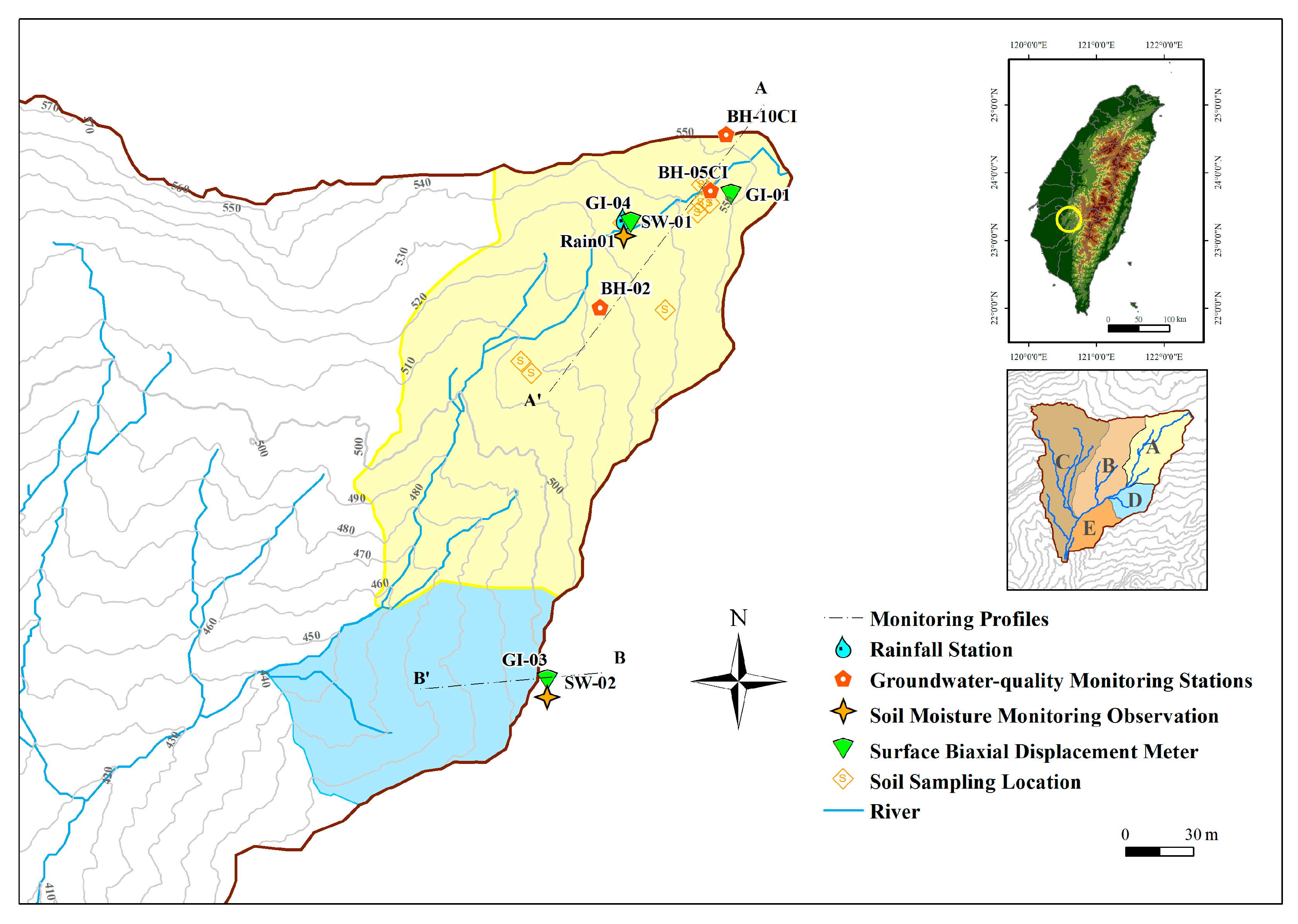
Figure 1. The location of the stations in Babaoliao area.
Geosciences 14 00274 g001
Figure 2. Mohr circle-based conceptual illustration of Local Factor of Safety [66].
Geosciences 14 00274 g002
Figure 3. Flowchart of the modeling analysis process.
Geosciences 14 00274 g003
Figure 4. Conceptual model, boundary condition, and mesh configuration: (a) zone A, (b) zone D.
Geosciences 14 00274 g004
Figure 5. Comparison of SWCC obtained from pressure plate tests and SWCC used in the model.
Geosciences 14 00274 g005
Figure 6. Results of simulated and observed values for (a) groundwater level in zone A, (b) soil water content in zone A, and (c) soil water content in zone D.
Geosciences 14 00274 g006
Figure 7. Four hypothetical rainfall scenarios: (a) extreme intensity, (b) high intensity, (c) moderate intensity, and (d) low intensity.
Geosciences 14 00274 g007
Figure 8. Simulation results for (a) soil water content in zone A, (b) LFS in zone A, (c) soil water content in zone D, and (d) LFS in zone D.
Geosciences 14 00274 g008
Table 1. Details and location of monitoring equipment [68].
ZoneNo.InstrumentModelParameterUnitDepth [cm]Start Date
ARain 01Rain gaugeTK-1 Rain GaugeRainfall[mm]023 May 2018
SW-01Soil Moisture–Temperature–Electrical Conductivity MeterSWTC-100Volumetric water content[%]30, 1004 June 2019
5025 March 2021
Temperature[°C]50
Electrical Conductivity[μs/cm]50
GI-04Surface dual-axis inclinometerProcalDisplacement_X[degree]5017 June 2020
Displacement_Y[degree]50
DGI-03Surface dual-axis inclinometerProcalDisplacement_X[degree]5017 June 2020
Displacement_Y[degree]50
SW-02Soil Moisture–Temperature–Electrical Conductivity MeterSWTC-100Volumetric water content[%]5025 March 2021
Temperature[°C]50
Electrical Conductivity[μs/cm]50
Table 2. Hydraulic and mechanical parameters.
Hydraulic Parametersθr [-]θs* [-]α* [m−1]n* [-]Ks* [m/s]
ASoil 1.00   × 10−50.490.661.17 2.78   × 10−5
Regolith0.030.473.641.12 1.64   × 10−9
DRegolith0.030.473.641.12 2.78   × 10−6
Mechanical parametersGs [-]c [kPa] ϕ [°]E [kPa]ν [-]
ASoil2.7217.163220,0000.33
Regolith2.6468.652340,0000.33
DRegolith2.6468.652340,0000.33
θs*, α*, n*, and Ks* are the values after calibration.
Disclaimer/Publisher’s Note: The statements, opinions and data contained in all publications are solely those of the individual author(s) and contributor(s) and not of MDPI and/or the editor(s). MDPI and/or the editor(s) disclaim responsibility for any injury to people or property resulting from any ideas, methods, instructions or products referred to in the content.