Abstract
In the continuum of the land–sea interface, sediment reservoirs are often considered separately. Therefore, integrative research is necessary. This study focuses on sediments throughout the tributaries–river–estuary–ria pathway of the Ulla–Arousa system, aiming to quantify trace element contents, identify land sources, determine background levels, and assess sediment enrichment and contamination states. The elements Al, As, Cr, Cu, Fe, Ni, Pb, Sb, U, and Zn were determined in 78 sediment stations. Two approaches were considered. First, background functions and enrichment factors were estimated using Al or U as the reference element. Second, a statistical study was conducted using distribution analysis, which helped identify trace element sources and their influences throughout the basin. The results revealed two significant sources of trace elements. One source is the amphibolite massif of the Arinteiro Unit, influencing the Brandelos (Cu) and Lañas (Fe) tributaries. Another source is the Deza tributary (As, Sb). However, these alterations do not reach the estuary, where anthropogenic sources (Cr, Cu, Ni) dominate. In the inner Ria of Arousa, only a light Cr enrichment was observed. The integrated study of the Ulla–Arousa system provides valuable patterns to understand and address heterogeneous land–sea systems.
1. Introduction
In pristine rivers, trace elements naturally enter water bodies through erosive processes involving surface rocks containing minerals, leaching from soils, and natural biological material [1]. However, the advent of industrialization has led to a significant increase in anthropogenic activities, disrupting natural biogeochemical cycles [2,3]. This disruption is primarily caused by the intensive release of organic matter, fertilizers, and metals into river environments from both treated and untreated municipal and industrial effluents [4]. These sediment contaminants are then transported from river basins to estuarine margins, estuaries, and coastal ocean areas [5,6], directly altering natural processes due to human activities [7,8,9].
Anthropogenic disturbances can also indirectly reduce riverine sediment transport, with damming being the most influential factor in sediment retention [10]. Additionally, aquaculture activities, port activities, fishing, industrial zones, and tourism contribute to the overexploitation of water resources, disrupting river estuary–ocean dynamics and material transport. Several studies demonstrate that human activities and changes in river discharge can modify the biogeochemical conditions of coastal marine waters, as observed in Spain [11,12,13], and the accumulation of sediments on the seafloor [14,15,16].
Surface sediments serve as a record of natural and anthropogenic processes, making it ideal for assessing the health status of heterogeneous systems, such as the tributaries–river–estuary–ria of the Ulla–Arousa continuum. Despite previous studies focusing on the anthropogenic impact on trace elements at various global scales, with an emphasis on large global basins [3,17], rivers with lower flow received less attention, and sediment research has been lacking in the Ulla River basin. Additionally, different sediment reservoirs in heterogeneous systems, such as river–ria cases ([18] and references cited therein). For example, some studies have exclusively focused on Ulla estuary sediments [19] or the Ria of Arousa sediments [20,21] without considering the Ulla River or its tributaries.
Given that Galician Rias act as metal deposition boundaries [18], similar to other coastal systems (e.g., [22,23,24]), understanding the origin and contents of trace elements in the Ulla–Arousa sediment reservoir is essential, as metals can become toxic to living organisms. Therefore, this study comprehensively analyses the entire Ulla–Arousa continuum, from the Portodemouros reservoir to the sea, including the main tributaries (Lañas, Brandelos, Deza, Liñares, and Sar rivers), the main stretch of the Ulla River, its estuary, and the inner area of the Ria of Arousa. By understanding the origin and distribution of sediment trace elements throughout the tributaries–river–estuary–ria system, it becomes possible to properly assess enrichment and contamination from lithogenic and anthropogenic sources.
With this approach, the main objective is to determine the natural background contents and human footprint in the sediments of this heterogeneous system (tributaries, river, estuary, ria) as a whole by analysing trace element contents in the sedimentary reservoir. The specific goals are (i) to quantify the trace element sediment contents and background levels to evaluate present and future alterations; (ii) to identify the main sources of major and trace elements, along with sediment enrichment and contamination; and (iii) to provide a procedure to address heterogeneous land–sea systems.
2. Survey Area
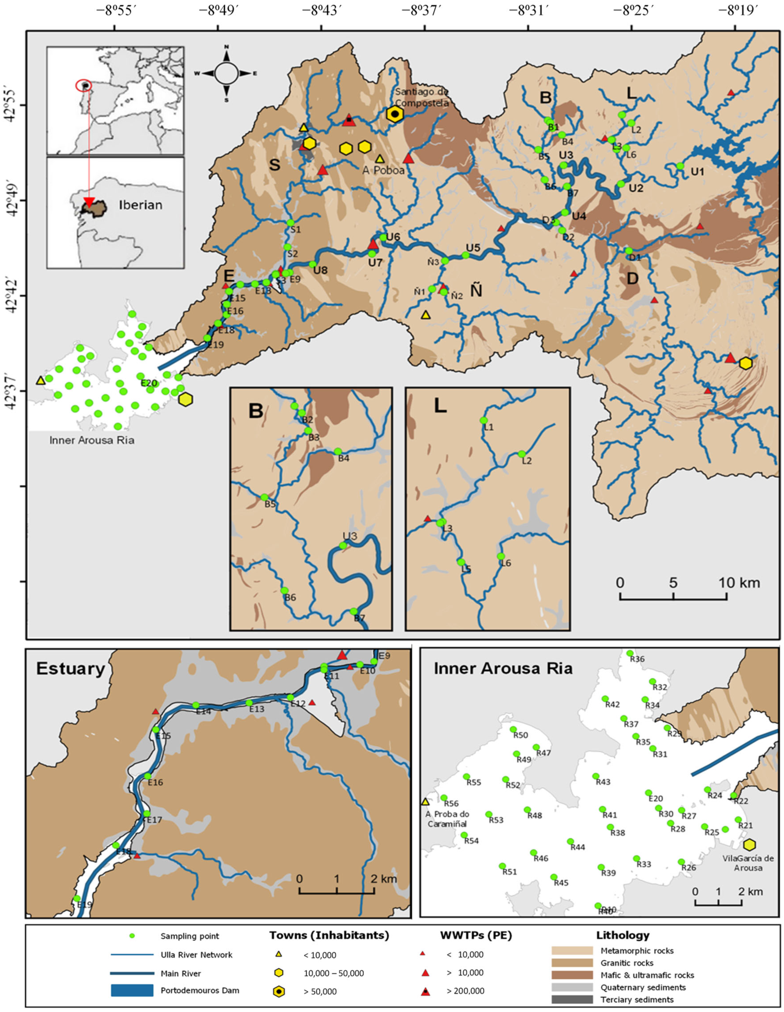
The Ulla–Arousa system is situated in the northwest of the Iberian Peninsula and encompasses the Ulla fluvial basin, which covers an area of 2804 km2. The Ulla River flows for a length of 131 km and discharges into the Ria of Arousa at an average annual flow rate of 79.3 m3·s−1 [25]. The north bank of the Ulla River is fed by the Lañas, Brandelos, and Sar tributaries (Figure 1). Lañas and Brandelos receive water from a network of rills, such as Beseño (L2 and L6 points, Figure 1); Portapego (L3 and L4) in the Lañas stream; and Pucheiras (B4), Noallas (B5), and Prevediños (B6) in the Brandelos stream. The Sar tributary flows into the estuary with an annual average flow of 7.0 m3·s−1. On the south bank, the Deza discharges 18.6 m3·s−1 (annual average, [25]) into the Ulla River, and the Liñares tributary contributes 6.0 m3·s−1. The inner part of the Ria of Arousa occupies approximately half of the total surface area of the estuary, which is about 230 km2.
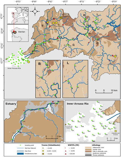
Figure 1.
Geographical representation of towns, treatment plants, major lithological and hydrological features, and sampling points within the Ulla–Arousa drainage basin system. The map was created using shapefiles from the CMATI web service (Xunta de Galicia). Sampling sediment points are indicated as green circles on the map. Tributaries are identified by letters: L for Lañas; B for Brandelos; D for Deza; Ñ for Liñares; S for Sar; E for the Ulla estuary; and R for the Ria of Arousa.
In terms of natural conditions, the fluvial basin mainly comprises metamorphic rocks (54%), granite (29%), basic and ultrabasic rocks (12%), detrital deposits (5%), and minor intrusive rocks (<1%) [26]. Notably, the amphibolite massif in the Arinteiro Unit is rich in copper and iron minerals, along with zinc minerals such as chalcopyrite, pyrite, pyrrhotite, and sphalerite, which belong to the group of sulphides found in ancient volcanic-sedimentary units or oceanic interfaces [27]. The geology of the basin is illustrated in Figure 1. The middle section of the river features bands of basic, metamorphic, and granitic rocks of varying hardness. The closed copper mine of Touro, with tailings and abandoned mining areas, is located in the Arinteiro zone, representing the main anthropogenic influence in the area.
The land use in the basin also has a significant impact, with agricultural and livestock activities occupying 36% of the total area, including crop fields and pastures. Eucalyptus and coniferous forests cover 16% of the land, while mixed tree species account for 11%. Scrublands make up 9% of the area, and there are various complex associations of scrublands, agricultural mosaics, and tree species covering 18% of the land. Moreover, 16.5% of the entire basin comprises 23 protected areas of different categories. Within the course of the Ulla River, the Portodemouros hydroelectric dam, inaugurated in 1967, significantly alters the natural watercourse [28].
Based on data from the [29], around 350,000 people inhabit the Ulla River basin, with one-third of the population residing in the city of Santiago de Compostela, which is traversed by the Sar River. Additionally, there are 25 municipal wastewater treatment plants and various industries, mainly located near the banks of the Ulla basin and its estuary. These anthropogenic influences also extend to the inner part of the Ria of Arousa. The presence of 2318 mussel farming rafts, yielding approximately 250,000 t·yr−1 (i.e., 40% of European production), significantly impacts sediment quality [30]. Moreover, towns and port activities on the shores of the ria, such as Vilagarcía de Arousa (with 38,000 inhabitants and the main trading port of the ria) or A Poboa do Caramiñal (with 10,000 inhabitants and fishing port), contribute to the overall anthropogenic influence in the region.
3. Materials and Methods
A total of 78 surface sediment samples were collected along the stretch of the Portodemouros dam to the inner part of the Ria of Arousa (Figure 1) using clean procedures for trace metal sampling. Out of these, 42 samples were taken from the Ulla River, its tributaries (Lañas, Brandelos, Deza, Liñares, and Sar waterways), and the Ulla estuary. The remaining 36 samples were obtained from the inner part of the Ria of Arousa. In the continental domain, the samples were carefully collected from the riverbed using a telescopic arm on 4–6 September 2018). For sampling in the estuary and the ria, a boat was used, and samples were collected using a Van Veen dredge on 21 September 2018.
All sediment samples were stored in plastic containers and preserved in a cooler box during transportation. Once at the Laboratory of Marine Biogeochemistry (IIM-CSIC, Vigo, Spain), the samples were oven-dried at a temperature of 45 ± 5 °C until a constant weight was achieved. Subsequently, they were sieved through a 2 mm grid to eliminate gravel particles, using a vibratory sieve shaker Retsch AS 200 Digit. The sand and mud fraction, consisting of particles with a size < 2 mm, was then ground in an agate ball mill (Fritsch Pulverisette) to reduce and homogenize the particle size for further analysis.
The ‘Analytical Service for the Determination of Metals in the Marine Environment’ at IIM-CSIC processed the prepared samples for trace element analysis. In a clean laboratory, the <2 mm sediment fraction was subjected to acid digestion using a hot plate inside a fume hood. Approximately 30 mg of the fraction were weighed into Teflon flasks, and then addition of 3 mL of 69% hyperpur HNO3 (Panreac), 1 mL of 40% suprapur HF (Merk), and 0.5 mL of 30% suprapur HCl (Merk) were added to each flask. The first digestion was carried out on the hot plate at 195 °C for 4 h. After this step, 5 mL of 5% H3BO3 were added to each flask to neutralize HF, and the samples were digested again at 195 °C for another 4 h. The resulting digests were then transferred to 50 mL volumetric flasks, rinsed, and brought to volume with Milli-Q water. For quality control, two procedural blanks and two certificate reference materials (CRMs, PACS-2, and MESS-4 from the National Research Council of Canada) were included in each digestion set. Additionally, an internal standard consisting of Ge, In, and Ir at a final concentration of 0.1 mg·L−1 was added to all solutions, including blanks, CRMs, and samples.
The element composition of the samples (Al, As, Cr, Cu, Fe, Ni, Pb, Sb, U, and Zn) was determined using Inductively Coupled Plasma Mass Spectrometry (ICP-MS) on an Agilent 7900 instrument. The results of the analytical control using CRMs are presented in Table 1.

Table 1.
Certified and analysed element contents in the certified reference materials PACS-2 and MESS-4 of the National Research Council of Canada. The “≈” shows an indicative content. Data are in mg·kg−1, except Al and Fe, which are in g·kg−1.
The statistical data treatment was conducted using IBM SPSS Statistics 25 and Statgraphics Centurion 18 software. To estimate the background levels, a least squares regression method was employed, following established procedures [31,32,33,34]. This approach relates the natural content of a target element (TE) to that of a reference element (RE), represented by two constants: the slope (a) and the intercept (b). The background for each individual sample can then be estimated using the background function (Equation (1)):
where [TE]BG(i) represents the estimated background for the target element (TE) in sample i, and [RE](i) denotes the measured content of the reference element in the same sample. Once the background levels were determined, the enrichments were evaluated using the local enrichment factor (LEF; [35]) calculated according to Equation (2):
[TE]BG(i) = a[RE](i) + b
LEFTE(i) = [TE](i)/[TE]BG(i)
In this equation, LEFTE(i) represents the local enrichment factor (LEF) calculated for each sample i, and [TE](i) corresponds to the measured content of the target element in that sample. The selection of the reference element is a crucial step in such studies [34], and for this study, U was tested as the reference element based on its suitability established in a previous work [35]. Aluminium and Fe were also considered to be the most used reference elements [36].
4. Results and Discussion
4.1. Sediment Contents
The sediments in the Ulla–Arousa basin exhibit significant variation in particle size. A geographical land-to-ocean factor influences the particle size abundance, with sediments collected from the inner part of the Ria of Arousa being predominantly fine (<0.063 mm, averaging 85%), while in the fluvial domain, the sand fraction is higher (averaging 82% of particles between 2 mm and 0.063 mm). As a result, three distinct areas can be distinguished based on the particle size: (i) the fluvial domain in the Ulla River basin dominated by sands (<20% mud); (ii) the transition area of the estuary (58% sand predominance); and (iii) the coastal domain in the ria (83% of samples consisting of only mud). On average, 54% of the sediment samples contain more sand than mud. To ensure representativeness in the samples and to consider the high variability of grain texture, the results presented henceforth will be relative to the <2 mm fraction.
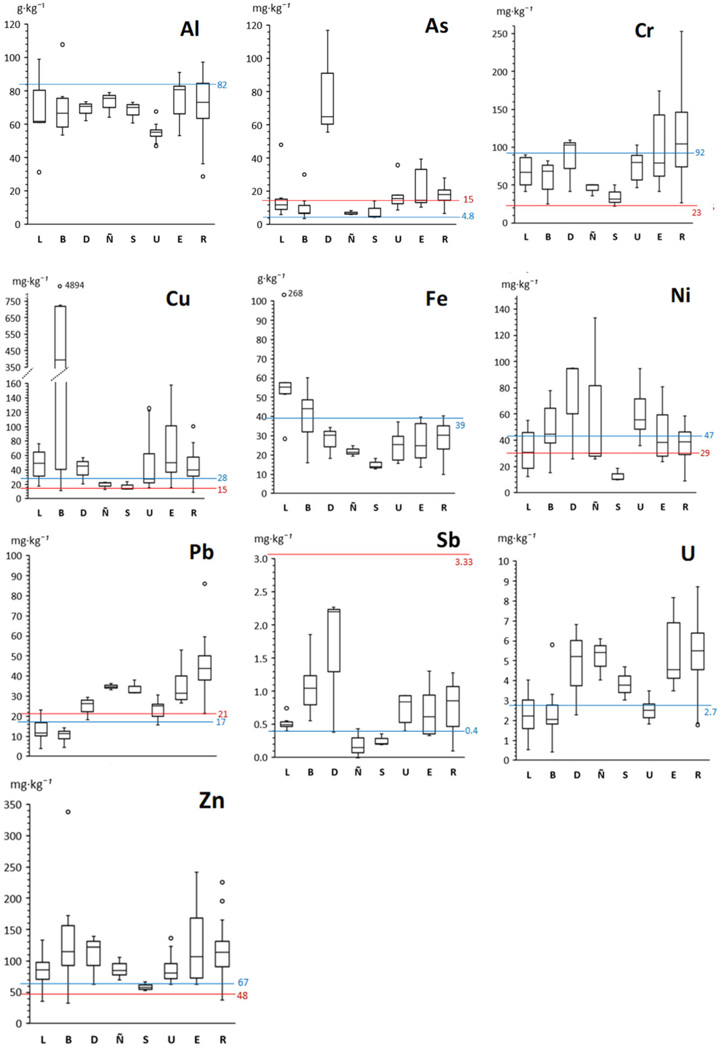
The summary of the elemental composition of the samples is detailed in Figure 2, showing the sediment content of twelve chemical elements by sub-basins: five Ulla tributaries, the Ulla River channel, the Ulla estuary, and the inner part of the Ria of Arousa. Overall, the average and median element contents in the sediment of the different sub-basins are comparable to the upper continental crust and Galician soils (Figure 2), with some localized enrichments observed. Outliers in Figure 2 indicate possible localized enrichment anomalies compared to the median values for each sub-basin.
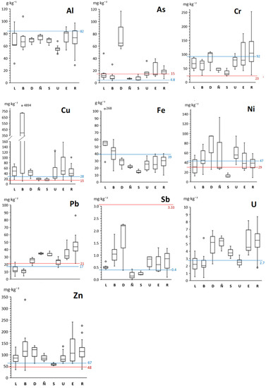
Figure 2.
Box and whisker plots detailing the analysis results of the <2 mm sediment fraction from various locations within the Ulla–Arousa system, including the Ulla tributaries Lañas (L), Brandelos (B), Deza (D), Sar (S), and Liñares (Ñ), as well as the Ulla riverbed (U), its estuary (E), and the inner Arousa Ria (R). Red lines represent the reference average contents in Galician sedimentary soils [37], and the blue line indicates the average contents in the upper continental crust [38], providing context for comparison.
Certain stations in the Ulla tributaries, such as Lañas (268 gFe·kg−1), Brandelos (4890 mgCu·kg−1; 338 mgZn·kg−1), and Deza (117 mgAs·kg−1; 2.3 mgSb·kg−1), stand out for their elevated element contents. Additionally, to a lesser extent, elevated levels of Cr (150–250 mgCr·kg−1) were observed in several sediment sampling points in the inner Ria of Arousa.
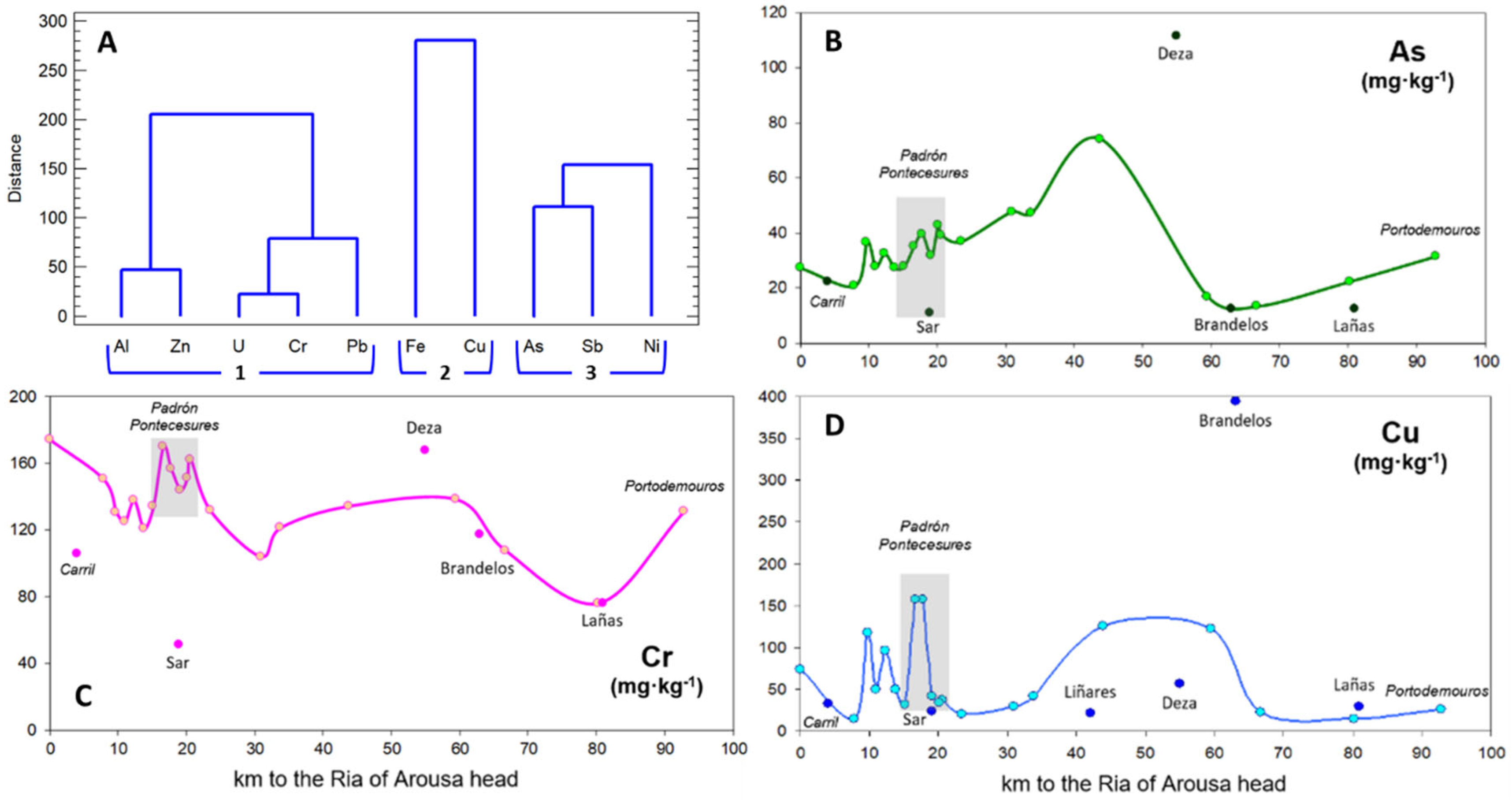
Cluster analysis (CA) was utilized to investigate the relationships between the twelve chemical elements (Figure 3A). The analysis revealed three main groups, each comprising specific elements: (1) Al, Cr, Pb, U, and Zn; (2) Cu and Fe; and (3) As, Ni, and Sb.
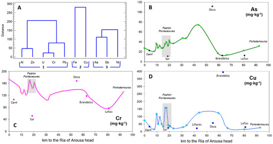
Figure 3.
Dendrogram (A) displaying the results of the cluster analysis using Ward’s method and squared Euclidean distance, showing the three distinct groups of target elements in the Ulla–Arousa system. Sediment content (B–D) of representative target elements (As, Cr, and Cu from cluster analysis, groups 1, 2, and 3, respectively) throughout the Ulla River and its estuary (from Sar to Carril) is also presented. The content of main tributaries near their mouths and the twin towns’ influence on the Ulla estuary (shaded area) are highlighted.
The first group (1) primarily corresponds to lithological influences, typical of granitic rocks with alkaline lithology, mainly concentrated towards the estuary and the interior of the ria (Figure 3C). In the second group (2), Cu and Fe demonstrated consistent lithogenic origins with an increase in concentrations, particularly in the Lañas (Portapego rill, L4; see Figure 1) and Brandelos (rills in upper tributary, B2–B4) small streams, which drain the old mine area in the Arinteiro Unit; noteworthy elevated values were also observed in the estuary after the confluence of the Ulla River with the Sar River (Figure 3D). The third group (3) is associated with mineralization arising from the natural lithology of the area, represented by metavolcanic schists, as well as agricultural fertilizer present in the Deza basin (Figure 3B).
4.2. Exploratory Estimation of Background
To assess the influence of extreme values on the departure from normality, an iterative detection and deletion of outliers was performed using Tukey’s inner fences (low limit Q1 − 1.5·IQR, high limit Q3 + 1.5·IQR, IQR = Q3 − Q1). The resulting dataset generally exhibited standard kurtosis and skewness within the range +2 to −2 or relatively close to this range, representing a general normal distribution. The result of the iterative selection of outliers is presented in Table 2.

Table 2.
Exploratory statistics of the dataset representing the content of chemical elements in the <2 mm sediment fraction after iterative deletion of outliers in the Ulla–Arousa system. The elemental contents are expressed in mg·kg−1, with the exception of Al and Fe, which are in g·kg−1.
The elements Cr, Cu, and Ni fall outside the normal range, exhibiting standardized skewness values of 2.1, 2.2, 2.0, and 2.6, respectively. Outliers serve as valuable indicators to identify potential enrichment patterns within the study area (Table 2). With the iterative detection of outliers, the sources of elements in the Ulla–Arousa system become clearer, allowing for a better understanding of their spatial distribution. Specifically, sediments from the head and middle reaches of the Brandelos tributary (B) exhibited enrichment in Cu (stations B2, B3, B4, B7; Figure 1), which may influence the Ulla River channel (U4, U5). Additionally, the sediments from the Deza tributary (D) show enrichment in As (D1, D2, and D3) and Sb (D2 and D3), while two rills of the Lañas tributary (L) display enrichment in Fe (L4) and As (L6). On the other hand, no other studied elements seem to exhibit any significant enrichment pattern based solely on the presence of outliers, except for Cu and Zn in the Ulla estuary (E12, E13).
The average levels (mean ± SD, Table 2) resulting from the varied geology of the basin, characterized by basic, metamorphic, and granitic rocks (Figure 1), can be used as an approximation to determine the baseline sediment content [33] for the entire Ulla–Arousa continuum. These local values for the largest river–ria system in Galicia can be compared stepwise with those at different scales (Table 2). Regionally, they align with the Galician sedimentary soils [37], at the peninsular level with the floodplain sediments in Spain [40], and globally with the upper continental crust [38]. The sediment contents of As, Fe, Pb, and Sb are within or lower than the values of Galician and Spanish sediments, while Cr, Cu, Ni, and Zn are somewhat higher but comparable to those found in the continental crust. It is crucial to consider the sediment contents of the Ulla–Arousa system specifically in order to consider the local natural variability.
4.3. Background Functions and Enrichment Factors
To estimate the background, iterative least squares regression was performed to calculate background functions. Aluminium, Fe [36], and U [35] were considered as potential reference elements. However, Fe exhibited a single anomalous value in the Portapego rill (L4) of 268 g·kg−1, raising suspicion of contamination. Consequently, Fe was rejected as a reference element and included within the target elements. After performing the regression and obtaining the background functions (Table 3), the selection of the most appropriate reference element was based on the correlation coefficient value (R > 0.5) and the number of samples remaining in the regression function after deleting unusual residuals (n > 50% of samples).

Table 3.
Regression functions between reference elements (Al, Fe, and U) and the target elements. The data involved are in mg·kg−1, except Al and Fe in g·kg−1.
Upon evaluating the correlation coefficient and the number of samples involved in the background function, Al was found to be suitable for normalizing Cr, Cu, Zn, and Fe, while U was suitable for As, Ni, Pb, and Sb. The corresponding background functions from Table 3 were selected and used to calculate the local enrichment factors (LEFs). A criterion of LEF > 2 was chosen to identify significant enrichments, indicating that the measured content is higher than two times the background estimation. This criterion is slightly more restrictive than the EF > 3 threshold adopted by [40] but closer to the classification presented by [41], who stated an EF between 1.5 and 2.0 to identify slight enrichment.
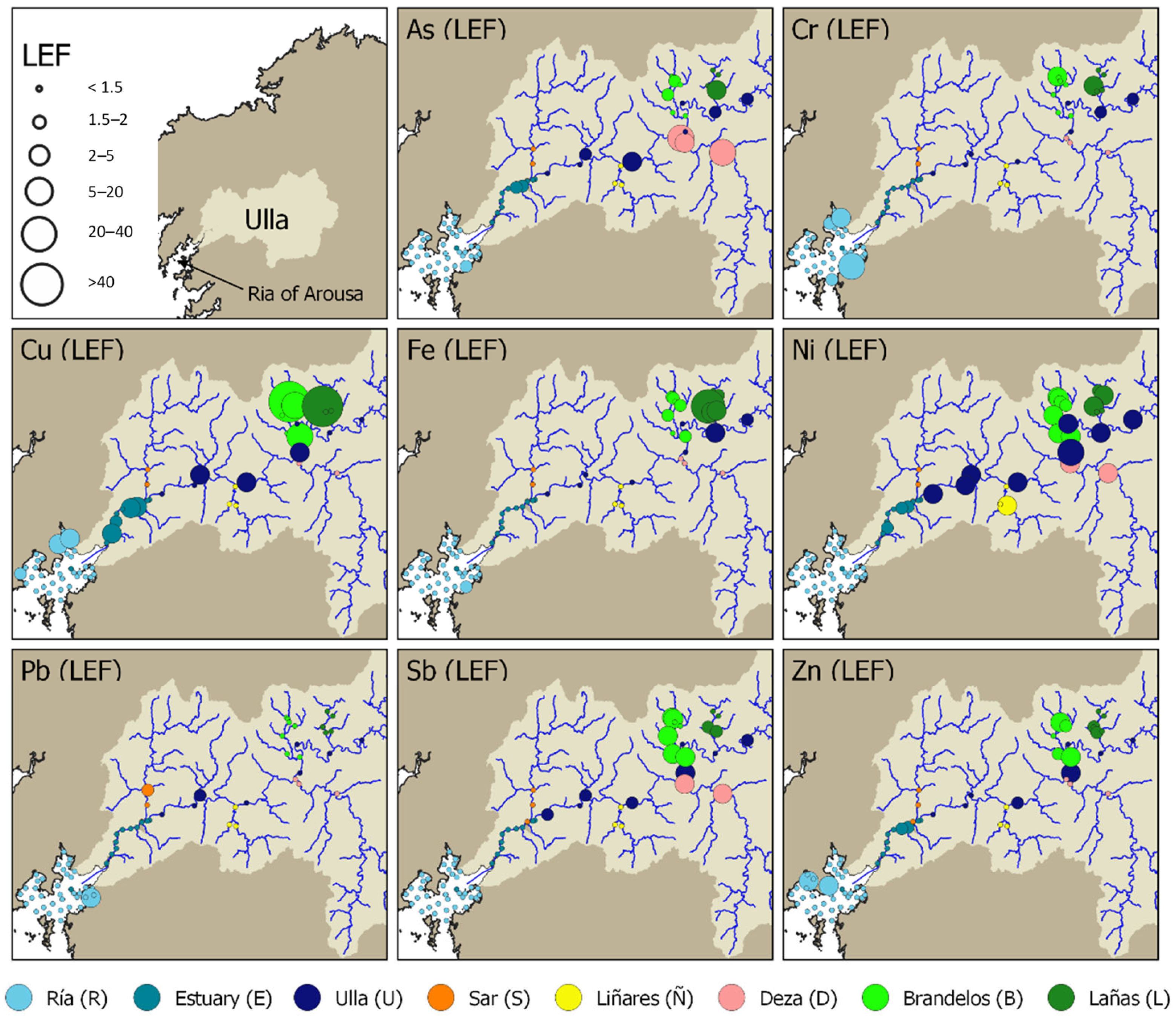
On average, for the entire Ulla–Arousa basin, the median LEF values remain below the threshold of two and even below 1.5, with values of 1.1 for As, 1.0 for Cr, 1.0 for Cu, 1.0 for Fe, 1.2 for Ni, 1.0 for Pb, 1.1 for Sb, and 1.1 for Zn. However, values significantly exceeding the background (LEF > 2) are limited to specific samples or sub-basins, particularly in the headwaters of the Lañas and Brandelos tributaries, as well as in the Deza River.
In the Lañas tributary, which drains the eastern side of the Touro mine, elevated LEF values were found for As (4.7 in L6); Cr (4.6 in L4); Cu (93 in L4, although not corresponding to a high content value, 67 mgCu·kg−1); Fe (27 in L4, 2.5 in L5, and 2.3 in L6); Ni (2.1 in L2, 3.5 in L3, and 2.2 in L4); and Sb (2.0 in L4). The Portapego stream (L4), which directly drains from the former mine, exhibits the highest LEF values in the Lañas sub-basin and in the entire Ulla–Arousa system for Cr (4.6), Cu (93), and Fe (27). In the Brandelos stream, draining the western side of the mine, elevated LEF values were observed for Cr (4.3 in B1); Cu (31 in B2, 62 in B3, 15 in B4, and 11 in B7); Fe (2.0 in B4 and B5); and Ni (3.1 in B1, 4.3 in B2, 2.4 in B5, 2.8 in B6, and 4.8 in B7). The Deza River is particularly enriched in As (5.9 in D1, 3.8 in D2, and 5.5 in D3), Ni (2.7 in D2 and 2.1 in D3), and Sb (3.0 in D2 and 2.4 in D3).
The main channel of the Ulla River also exhibits some enrichments ranging from slight to moderate, particularly in Ni (ranging from 6.5 in U4 to 2.2 in U8, with all U samples showing enrichment in this trace metal). Punctual enrichments were also observed in Cu (4.7 in U4, 3.3 in U5, and 2.5 in U6), Fe (2.1 in U2), Sb (2.5 in U4), and Zn (2.2 in U4). The Ulla estuary presents localized enrichments only in Cu in an urban area (3.0 in E12 and 2.7 in E13) and close to the marine domain (2.3 in E18). The innermost part of the Ria of Arousa shows highly localized enrichments in harbor areas (4.5 for Pb in R21, and 15 for Cr in R42) and in other parts of the area for Cr (2.4 in R53), Cu (3.7 in R51, and 2.8 in R53), and Zn (2.1 in R30 and 2.3 in R37). A graphical representation of the LEFs, according to the criterion of [41], is presented in Figure 4.
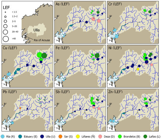
Figure 4.
Graphical representation of the Local Enrichment Factors (LEFs) for representative target elements (As, Cr, Cu, Fe, Ni, Pb, Sb, and Zn) in the Ulla–Arousa system. LEFs were calculated based on estimated background functions using Al as the reference element for Cr, Cu, Zn, and Fe and U as the reference element for As, Ni, Pb, and Sb. The LEF values are presented in comparison to the background estimation.
4.4. Environmental Assessment
A multiple line of evidence was employed in this study, encompassing different approaches to support the results. Firstly, visual observation of the data and their trends within the studied system (Figure 3) was conducted. Secondly, the data were explored using the Tukey inner fences, a non-parametric technique used not only to estimate background [42] but also to identify outliers or values within the dataset that may belong to a different population. The third approach involved calculating local enrichment factors (LEFs, [34]) by estimating the background through least squares regression using a reference element to account for particle size effects [43]. By applying a criterion [41], the LEFs were used to detect such as enrichments and depletions in the study area. The three approaches revealed three areas of concern in the Ulla–Arousa system: (i) the Arinteiro Unit (rich in Cu and formerly exploited for mining), (ii) the Deza River, and (iii) the estuarine urban area between the localities of Padrón and Pontecesures.
The Arinteiro Unit, drained by the small rivers Lañas and Brandelos, is characterized by high contents of Cu and Fe and, to a lesser extent, Cr, Ni, Sb, and Zn (Figure 4). This area is naturally enriched in trace elements, and evidence is that the area was exploited for Cu mining; hence, local contents are expected to be elevated because the trace elements are present in the local lithology. However, former mining activities could be increasing the loads of trace elements, even decades after mining has ceased [44]. Consequently, a combination of natural, mainly, and also residual anthropogenic factors, disused mine, could be the reason for the enrichments observed in this area. It is noteworthy that the increased export of trace elements does not appear to overload the carrying capacity of the Ulla River, as the elevated contents are diluted downstream and become negligible before reaching the estuary.
The Deza River exhibits high contents and enrichments in As and Sb (Figure 4). Both elements are metalloids with similar geochemical behavior, suggesting that their enrichment could be primarily influenced by the local lithology. However, human sources should also be considered. In the nearby Umia River, which also drains into the Ria of Arousa, enrichments in As were attributed to the historical use of pesticides in vineyards and other cultivations [45]. Although As pesticides are now forbidden in Spain, residual amounts may persist in soils and continue to be exported.
The urban portion of the estuary, located between the Padrón (>8000 inhabitants) and Pontecesures (3000 inhabitants) towns and also hosting some industrial activities, showed enrichments in Cu, Zn, and As (Figure 4). These enrichments could be attributed to increased inputs of these elements to the sediments through physico-chemical processes related to the mixing of fresh and saltwater. Nevertheless, these elements are common contaminants in urban [46] and industrial [47] wastewater, suggesting that anthropogenic sources cannot be ruled out.
Additionally, harbor areas along the ria shore also exhibited enrichments in Pb, Cr, Cu, and Zn (Figure 4), as has been pointed out in harbor areas of the Galician Rias [48,49].
5. Conclusions
The combination of multiple lines of evidence in this study has demonstrated its potential for environmental evaluation at a basin scale in the Ulla River, utilizing simple statistical tools with empirical significance to identify values deviating from the general trend. While enrichments in trace elements are often associated with contamination, distinguishing between natural and anthropogenic influences requires a thorough assessment of potential sources in order to achieve a comprehensive understanding of trace element imprints in sediments.
Regarding the environmental settings of the Ulla–Arousa system, the results of the exploratory statistical approach and background regression functions have identified two distinct sources of trace elements. The first source originates from the amphibolite massif of the Arinteiro Unit, affecting the upper basin of Brandelos and Lañas tributaries through certain rills. The influence of this source diminishes as it mixes with other sediments within both tributaries and as it reaches the confluence with the Ulla River, the metal contents decrease significantly. Beyond the mouth of Deza, the impact on Ulla sediment becomes minimal. The second source is the Deza tributary, which flows through an agricultural region and is joined by the Liñares tributary. However, these alterations do not extend to the estuary, where anthropogenic sources are observed in the towns of Padrón and Pontecesures, as well as in the vicinity of the Sar tributary. In the inner part of the Ria of Arousa, which serves as the final depository of fluvial sediments, only small and localized enrichments are observed.
In conclusion, this comprehensive study has shed light on the sources and distribution of trace elements in the integrated Ulla–Arousa system, providing valuable insights for environmental management and conservation efforts in the region and, moreover, valuable patterns to understand and address heterogeneous land–sea systems.
Author Contributions
Conceptualization, R.P., M.Á.Á.-V. and G.F.; methodology, R.P., M.Á.Á.-V. and G.F.; software, M.Á.Á.-V. and G.F.; validation, R.P. and M.Á.Á.-V.; data curation, R.P.; writing—original draft preparation, R.P., M.Á.Á.-V. and G.F.; fieldwork, R.P. and M.Á.Á.-V. All authors have read and agreed to the published version of the manuscript.
Funding
This research was funded by the project AMBARULLA (CSIC code: 20181970; Cobre San Rafael code CSR000768-1) and by the support to the group ‘Océano’ from the ‘Consolidation and Structuring of Competitive Research Group’ program of the Xunta de Galicia, grant number IN607A2021/04. M.Á.Á.-V. was supported by the ‘Xunta de Galicia’, postdoctoral grant ED481D 2023/006, and G.F. was supported by the JAE-Intro grant JAEICU-20-IIM-01.
Data Availability Statement
Not applicable.
Acknowledgments
The authors thank technician Susana Calvo for sediment pre-treatment and Antonio Cobelo-García for ICP-MS analysis. M.Á.Á.-V. was supported by the ‘Xunta de Galicia’, postdoctoral grant ED481D 2023/006, and G.F. was supported by the JAE-Intro grant JAEICU-20-IIM-01.
Conflicts of Interest
The authors declare no conflict of interest.
References
- Martin, J.M.; Meybeck, M. Elemental Mass-Balance of Material Carried by Major World Rivers. Mar. Chem. 1979, 7, 173–206. [Google Scholar] [CrossRef]
- Gaillardet, J.; Viers, J.; Dupré, B. Trace Elements in River Waters. Treatise Geochem. 2003, 5, 225–272. [Google Scholar] [CrossRef]
- Meybeck, M.; Vörösmarty, C. Fluvial filtering of land to ocean fluxes: From natural Holocene variations to Anthropocene. Comptes Rendus Geosci. 2005, 337, 107–123. [Google Scholar] [CrossRef]
- Meybeck, M.; Friedrich, G.; Thomas, R.; Chapman, D. Rivers. Water Quality Assessments. In A Guide to Use of Biota, Sediments and Water in Environmental Monitoring, 2nd ed.; Chapman, D., Ed.; UNESCO: Paris, France; WHO: Geneva, Switzerland; UNEP: Nairobi, Kenya, 1996; pp. 239–316. ISBN 0419215905(HB)0419216006(PB). [Google Scholar]
- Clark, R. Organotin in the surface microlayer and subsurface waters of south west England. In Marine Pollution, 5th ed.; Oxford University Press: Oxford, UK, 2001; Volume 18, pp. 238–246. ISBN 0-19-879292-1. [Google Scholar]
- Birch, G.F.; Olmos, M.A. Sediment-bound heavy metals as indicators of human influence and biological risk in coastal water bodies. ICES J. Mar. Sci. 2008, 65, 1407–1413. [Google Scholar] [CrossRef]
- Callender, E. Heavy metals in the environment-historical trends. Treatise Geochem. 2003, 9, 68–69. [Google Scholar] [CrossRef]
- Navrátil, T.; Minařík, L. Trace elements and contaminants. Earth system: History and natural variability. In Encyclopedia of Life Support Systems; EOLSS: Abu Dhabi, United Arab Emirates, 2005; Volume 4, pp. 250–279. ISBN 978-1-84826-107-5. [Google Scholar]
- Syvitski, J.P.M.; Vörösmarty, C.J.; Kettner, A.J.; Green, P. Impact of Humans on the Flux of Terrestrial Sediment to the Global Coastal Ocean. Science 2005, 308, 376–380. [Google Scholar] [CrossRef]
- Walling, D.E.; Fang, D. Recent trends in the suspended sediment loads of the world’s rivers. Glob. Planet. Chang. 2003, 39, 111–126. [Google Scholar] [CrossRef]
- Cearreta, A.; Irabien, M.J.; Leorri, E.; Yusta, I.; Croudace, I.W.; Cundy, A.B. Recent anthropogenic impacts on the Bilbao Estuary, northern Spain: Geochemical and microfaunal evidence. Estuar. Coast. Shelf Sci. 2000, 50, 571–592. [Google Scholar] [CrossRef]
- Olías, M.; Cánovas, C.R.; Nieto, J.M.; Sarmiento, A.M. Evaluation of the dissolved contaminant load transported by the Tinto and Odiel rivers (South West Spain). Appl. Geochem. 2006, 21, 1733–1749. [Google Scholar] [CrossRef]
- Álvarez-Vázquez, M.A.; Prego, R.; Ospina-Alvarez, N.; Caetano, M.; Bernárdez, P.; Doval, M.; Filgueiras, A.V.; Vale, C. Anthropogenic changes in the fluxes to estuaries: Wastewater discharges compared with river loads in small rias. Estuar. Coast. Shelf Sci. 2016, 179, 112–123. [Google Scholar] [CrossRef]
- Gao, S.; Wang, Y.P. Changes in material fluxes from the Changjiang River and their implications on the adjoining continental shelf ecosystem. Cont. Shelf Res. 2008, 28, 1490–1500. [Google Scholar] [CrossRef]
- Liquete, C.; Lucchi, R.G.; Garcia-Orellana, J.; Canals, M.; Masque, P.; Pasqual, C.; Lavoie, C. Modern sedimentation patterns and human impacts on the Barcelona continental shelf (NE Spain). Geol. Acta 2010, 8, 169–187. [Google Scholar] [CrossRef]
- Guo, Y.; Yang, S. Heavy metal enrichments in the Changjiang (Yangtze River) catchment and on the inner shelf of the East China Sea over the last 150 years. Sci. Total Environ. 2016, 543, 105–115. [Google Scholar] [CrossRef] [PubMed]
- Viers, J.; Dupré, B.; Gaillardet, J. Chemical composition of suspended sediments in World Rivers: New insights from a new database. Sci. Total Environ. 2009, 407, 853–868. [Google Scholar] [CrossRef] [PubMed]
- Prego, R.; Cobelo-García, A. Twentieth century overview of heavy metals in the Galician Rias (NW Iberian Peninsula). Environ. Pollut. 2003, 121, 425–452. [Google Scholar] [CrossRef]
- Prego, R.; Belzunce, M.; Cobelo, A.; Helios-Rybicka, E. Particulate metal in the Ulla River estuary: State and sources of contamination (Arosa Ria, NW Iberian Peninsula). Cienc. Mar. 2008, 34, 381–388. [Google Scholar] [CrossRef]
- Barciela-Alonso, M.C.; Pazos-Capeáns, P.; Regueira-Miguens, M.E.; Bermejo-Barrera, A.; Bermejo-Barrera, P. Study of cadmium, lead and tin distribution in surface marine sediment samples from Ria de Arousa (NW of Spain). Anal. Chim. Acta 2004, 524, 115–120. [Google Scholar] [CrossRef]
- Otero, X.L.; Vidal-Torrado, P.; Calvo De Anta, R.M.; Macías, F. Trace elements in biodeposits and sediments from mussel culture in the Ría de Arousa (Galicia, NW Spain). Environ. Pollut. 2005, 136, 119–134. [Google Scholar] [CrossRef]
- Bryan, G.W.; Langston, W.J. Bioavailability, accumulation and effects of heavy metals in sediments with special reference to United Kingdom estuaries: A review. Environ. Pollut. 1992, 76, 89–131. [Google Scholar] [CrossRef]
- Millward, G.E.; Glegg, G.A. Fluxes and retention of trace metals in the Humber Estuary. Estuar. Coast. Shelf Sci. 1997, 44, 97–105. [Google Scholar] [CrossRef]
- Schäfer, J.; Coynel, A.; Blanc, G. Impact of metallurgy tailings in a major European fluvial-estuarine system: Trajectories and resilience over seven decades. Sci. Total Environ. 2022, 805, 150–195. [Google Scholar] [CrossRef] [PubMed]
- Río, F.; Rodriguez, F. Os Ríos Galegos, Morfoloxía e Réxime; Consello da Cultura Galega: Coruña, Spain, 1992; ISBN 978-84-87172-76-2. [Google Scholar]
- Instituto de Estudos do Territorio. Litoloxía de Galicia 1:50.000. Consellería de Medio Ambiente, Terriotrio e Infraestruturas—Xunta de Galicia. Available online: http://mapas.xunta.gal/visores/basico/ (accessed on 20 June 2023).
- Fuertes-Blanco, J. Mineralizaciones de Sulfuros Masivos en la Zona de Galicia Media Tras-os-Montes. Master’s Thesis, Universidad de Oviedo, Oviedo, Spain, 2019; p. 57. Available online: http://hdl.handle.net/10651/59416 (accessed on 10 June 2023).
- Hydrographic Demarcation of Galicia-Coast. Preliminary Report of Galician Waters for the Basin of the Ulla Marl Project Based on the Data Provided by the Hydrological Plan. 2011. Available online: https://augasdegalicia.xunta.gal/demarcacion-hidrografica (accessed on 15 January 2023).
- Galician Institute of Statistics. Population. Territory and Environment. Available online: https://www.ige.gal/web/index.jsp?idioma=es (accessed on 22 September 2023).
- Méndez Martínez, G.; Ovejero Campos, A.; Gómez Vilar, E.; Lastra Mier, R.E.; Pérez-Arlucea, M. Changes induced by mussel raft aquaculture in benthic environment of the Rías Baixas (Galicia, Spain). J. Coast. Res. 2011, 64, 786–789. Available online: https://www.jstor.org/stable/26482279 (accessed on 22 September 2023).
- Birch, G.F. Determination of sediment metal background concentrations and enrichment in marine environments—A critical review. Sci. Total Environ. 2017, 580, 813–831. [Google Scholar] [CrossRef]
- Dung, T.T.T.; Cappuyns, V.; Swennen, R.; Phung, N.K. From geochemical background determination to pollution assessment of heavy metals in sediments and soils. Rev. Environ. Sci. Biotechnol. 2013, 12, 335–353. [Google Scholar] [CrossRef]
- Matschullat, J.; Ottenstein, R.; Reimann, C. Geochemical background-can we calculate it? Environ. Geol. 2000, 39, 990–1000. [Google Scholar] [CrossRef]
- Matys-Grygar, T.; Popelka, J. Revisiting geochemical methods of distinguishing natural concentrations and pollution by risk elements in fluvial sediments. J. Geochem. Explor. 2016, 170, 39–57. [Google Scholar] [CrossRef]
- Álvarez-Vázquez, M.Á.; Farinango, G.; Prego, R. Uranium as reference element to estimate the background of “Anthropocene” sensitive trace elements in sediments of the land-ocean continuum (Ulla-Arousa, NW Iberian Atlantic Margin). Cont. Shelf Res. 2023, 261, 105021. [Google Scholar] [CrossRef]
- Birch, G.F. An assessment of aluminium and iron in normalisation and enrichment procedures for environmental assessment of marine sediment. Sci. Total Environ. 2020, 727, 138123. [Google Scholar] [CrossRef] [PubMed]
- Macías Vázquez, F.; Calvo de Anta, R. Generic Reference Levels of Heavy Metals and Other Trace Elements in Galician Soils; Ministry of Environment and Sustainable Development of the Xunta de Galicia: Santiago de Compostela, Spain, 2009. [Google Scholar] [CrossRef]
- Rudnick, R.L.; Gao, S. 4.1—Composition of the Continental Crust. In: Earth Systems and Environmental Sciences. In Treatise on Geochemistry, 2nd ed.; Elsevier Science: Amsterdam, The Netherlands, 2014; Volume 4, pp. 1–51. [Google Scholar] [CrossRef]
- Locutura, J.; Bel-Lan, A.; García Cortés, A.; Martínez, S. Atlas Geoquímico de España; Instituto Geológico y Minero de España: Madrid, Spain, 2012; ISBN 978-84-7840-875-7. [Google Scholar]
- Hakanson, L. An Ecological Risk Index for Aquatic Pollution Control a Sedimentological Approach. Water Res. 1980, 14, 975–1001. [Google Scholar] [CrossRef]
- Li, Y.; Zhou, H.; Gao, B.; Xu, D. Improved enrichment factor model for correcting and predicting the evaluation of heavy metals in sediments. Sci. Total Environ. 2021, 755, 142437. [Google Scholar] [CrossRef]
- Reimann, C.; Fabian, K.; Birke, M.; Filzmoser, P.; Demetriades, A.; Négrel, P.; Oorts, K.; Matschullat, J.; de Caritat, P.M. GEMAS: Establishing geochemical background and threshold for 53 chemical elements in European agricultural soil. Appl. Geochem. 2018, 88, 302–318. [Google Scholar] [CrossRef]
- Bábek, O.; Grygar, T.M.; Faměra, M.; Hron, K.; Nováková, T.; Sedláček, J. Geochemical background in polluted river sediments: How to separate the effects of sediment provenance and grain size with statistical rigour? Catena 2015, 135, 240–253. [Google Scholar] [CrossRef]
- García-Ordiales, E.; Flor-Blanco, G.; Roqueñí, N.; Covelli, S.; Cienfuegos, P.; Álvarez, R.; Fontolan, G.; Loredo, J. Anthropocene footprint in the Nalón estuarine sediments (northern Spain). Mar. Geol. 2020, 424, 106167. [Google Scholar] [CrossRef]
- Álvarez-Vázquez, M.Á.; González-Prieto, S.J.; Prego, R. Possible impact of environmental policies in the recovery of a Ramsar wetland from trace metal contamination. Sci. Total Environ. 2018, 637, 803–812. [Google Scholar] [CrossRef]
- Agoro, M.A.; Adeniji, A.O.; Adefisoye, M.A.; Okoh, O.O. Heavy metals in wastewater and sewage sludge from selected municipal treatment plants in Eastern Cape Province, South Africa. Water 2020, 12, 2746. [Google Scholar] [CrossRef]
- Lakherwal, D. Adsorption of Heavy Metals: A Review. Int. J. Environ. Res. Dev. 2014, 4, 41–48. [Google Scholar]
- Prego, R.; Ferro, P.; Trujillo, C. Lead and Zinc contamination of surface sediments in the main harbours of the Galician Rias. J. Iber. Geol. 2008, 34, 243–252. [Google Scholar]
- García, A.; Bernárdez, P.; Prego, R. Copper in Galician ria sediments: Natural levels and contamination. Sci. Mar. 2013, 77S1, 91–99. [Google Scholar] [CrossRef]
Disclaimer/Publisher’s Note: The statements, opinions and data contained in all publications are solely those of the individual author(s) and contributor(s) and not of MDPI and/or the editor(s). MDPI and/or the editor(s) disclaim responsibility for any injury to people or property resulting from any ideas, methods, instructions or products referred to in the content. |
© 2023 by the authors. Licensee MDPI, Basel, Switzerland. This article is an open access article distributed under the terms and conditions of the Creative Commons Attribution (CC BY) license (https://creativecommons.org/licenses/by/4.0/).

