Abstract
Risks posed by sea-level rise and cyclones are becoming more prevalent along the world’s coastlines. In recent years, tsunamis have had devastating impacts on communities in different ocean basins. Although storms and tsunamis can be clearly distinguished when they occur in the present, this does not apply to the past, from which only their traces in the form of sedimentary or geomorphologic features provide clues about their occurrence. Following a short review of research on tsunamis from the last decades, this study uses the example of coastal boulder deposits to highlight where knowledge gaps exist. This report focuses on the spatial distribution of sediment patterns and how these may provide clues to the transport processes. However, the history of these deposits and related sea-level records during the same time span must also be recorded and contextualized. Theoretical modeling results without including these parameters will remain fuzzy, if not inaccurate. This contribution points to the need for consideration of both data and nature’s reality (which are complementary and interdependent) in this field.
1. Introduction
Advances in scientific knowledge are fostered by consistent debate, deep inquiry, and dispute to find the best answers to scientific questions. The Earth sciences have an important advantage in this regard; they study natural phenomena and processes that occur at any place and time through the interplay of innumerable parameters and conditions under indisputable laws of nature. This haptic reality of nature is, therefore, in all dimensions the testing ground for the correctness of scientific hypotheses or an indicator for the degree of approximation to nature’s reality and thus, at the same time, the arbiter in a dispute. Disputes about the method and meaningfulness of artificial replicas of nature through calculations, experiments, and models are, therefore, disputes about these methods, but they do not touch the natural realities in any way. This article argues for a better integration of field evidence in hydrodynamic models that describe tsunami or storm processes.
2. Paleo-Tsunami Deposits—Origin, Appearance, and Scientific Challenges of Interpreting Deposits
2.1. Tsunami Sources, Distribution, and Risks
Until recently, tsunami phenomena have mostly been known in regions of the Earth with more frequent occurrences (e.g., East and Southeast Asia) and rather overlooked and unknown for others with less frequent events. The Andaman–Sumatra tsunami of 2004 and the Tokoku–Sendai tsunami in Japan in 2011 changed this perception by scientists and the wider public [1]. Today, we know through collections of eyewitness accounts or evaluation of historical sources that tsunamis have multiple causes and can potentially occur worldwide along all coasts [2,3,4,5,6,7,8,9,10,11,12,13,14,15,16,17,18,19,20,21,22,23,24]. In addition, there is geoscientific research on the forms and deposits left by paleo-tsunamis. Broad accounts of geomorphic signatures of tsunamis can be found in [10,23,24,25,26,27,28], among others, and summarized reviews in [11,28,29,30,31,32,33,34,35,36,37,38,39]. Worldwide and regional catalogues of tsunami occurrence back to prehistoric times (including assessment of source reliability) can be found in [40,41,42,43,44,45,46,47,48,49,50,51,52,53,54,55,56,57].
More than 2000 events have been documented since the Bronze Age, e.g., explosion and caldera formation of the Santorini volcano north of Crete around 1628 BCE [58,59] and the collapse of the Krakatau volcano in the Sunda Strait of Indonesia in 1883 CE with over 36,000 deaths [22,60,61,62].
Tectonic plate boundaries around the Pacific Ocean, characterized as the “Ring of Fire”, have continued to be the sources of about 80% of all tsunamis in any longer period of time. More than 600 events from the 19th century and more than 900 events from the 20th century can be found in the catalogues. This increase is certainly due to a constantly improving observation and measurement network. Casualty figures of more than 10,000 were recorded for, among others, the Enshunada tsunami in 1498 CE (>26,000 victims), the Nankaido tsunami in 1707 CE (>30,000), the Sanriko tsunami in 1896 CE (approximately 27,000), and the Ishigaku (Meiwa) tsunami in 1771 CE (approximately 13,000 victims); all these tsunamis were in Japan. A total of 116 tsunamis of the aforementioned >2000 tsunamis had a run-up value of >10 m, 38 of >20 m, and 11 of >50 m above sea level. Even tsunamis that cross the coastline with waves 2 m high are among those with considerable destructive potential. Transoceanic tsunamis (such as those in the Pacific from the Aleutian Islands in 1946 and 1957, from Kamchatka in 1952, from Alaska in 1964, and from Chile in 1960) still had a run-up of at least 5 m 5000 km from the point of origin. The recurrence intervals for large Pacific tsunamis with severe destruction are between about 20 and 150 years.
Numerical dating of initially unrecognized tsunamis supports the correct assessment of ancient sources and provides evidence for the large number of these “extreme events” [48,49,50,51,63,64,65,66,67,68,69,70,71,72]. A valuable compendium of individual events and local and regional impacts, together with theoretical approaches and attempts at interpretation, can be found in the dedicated journal “Science of Tsunami Hazards”, founded in 1982, which is now in its 40th year.
From these sources, we can establish the most important causes of tsunamis: earthquakes and seaquakes (often with submarine mass slides) and volcanic eruptions or volcanic explosions (e.g., the collapse on Santorini ca. 1628 BCE and Krakatau 1883 CE). The impact of cosmic objects is known from older geological periods (e.g., at the Cretaceous/Tertiary boundary 66–65 million years ago recorded in Mexico’s Yucatan region). Since tsunamis of great magnitude can overcome entire oceans (such as the Indian Ocean in the 2004 Andaman–Sumatra tsunami or the Pacific Ocean in the 2011 Tohoku–Sendai tsunami), we cannot completely eliminate the potential for tsunamis along any segment of the Earth’s coastline, not even for the short geological period of postglacial sea-level rise since about 7000 years ago.
On-time and near-time documents of strong tsunamis distributed worldwide have raised awareness of their risks on the coasts, and protective measures, or at least immediate warnings, have been and continue to be developed. Their necessity is clear by examining existing data: 32 stronger and more powerful tsunamis have been recorded in the 20th century alone, with a total of over 249,000 victims (including 7 with over 2000 deaths each), and there have already been 13 powerful tsunamis reported in the first 20 years of the 21st century, with >247,000 victims, including over 230,000 victims in Indonesia’s 2004 Andaman–Sumatra tsunami and over 18,000 victims in Japan’s 2011 Tohoku–Sendai tsunami.
2.2. Scientific Approach to the Tsunami Phenomenon, Based on Field Work to Identify Past Events
Owing to the frequent occurrence of moderate to extreme tsunamis and the connection to nature caused by religion and philosophy, Japan is not the only country experiencing this natural phenomenon; it is familiar to all inhabitants through historical facts and memory temples of large coral blocks (“tsunami ishi” = tsunami stone, see Figure 1) in the importance for safety and infrastructure. Research on paleo-tsunamis and on understanding the processes involved in current events also originated in Japan. This knowledge facilitates the acceptance of precautionary measures but does not protect against new disasters.
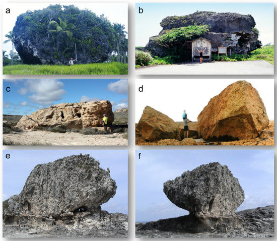
Figure 1.
Examples of exceptional large individual boulders deposited by tsunamis in the younger Holocene (a–d) and the Eemian period (e,f): (a) Tonga, about 2000 tons (Frohlich et al., 2009); (b) Tsunami block (“Tsunami-ishi“) from Japan, >1000 tons; (c) Western Australia, about 700 tons (Playford, 2014); (d) Quobba, Western Australia, about 90 tons, dated 1060 cal BP; (e) “Bull“, Eleuthera (Bahamas), about 950 tons; (f) “Cow“, Eleuthera (Bahamas), about 440 tons.
Although only less than one-third of the Earth’s coasts are composed of sandy beaches and other unconsolidated material or shallow sedimentary areas, more than 90% of all work on coastal research has been and is still devoted to these types of coastlines [71]. One reason is certainly the comparative simplicity of the landscape (vastness and overview, modest relief, and little variation in surface material); another reason is the well-developed methodology of sedimentological laboratory techniques applied to predominantly fine material. In addition, there seems to be a widespread belief that results obtained in one region can be easily and reliably transferred to others [10,73].
Examples for initial guidance to detect tsunamis in fine sedimentary deposits can be found in several published work (including [4,29,30,44,64,73,74,75,76,77,78]). Rocky coasts, in contrast, are extraordinarily heterogeneous in relief type, elevation, slope angles, rock types, weathering material, and other characteristics. However, they also offer advantages for scientific inquiry as it is considerably easier to obtain three-dimensional impressions and determine the (potential) range of marine processes. Moreover, with respect to potential littoral/marine-influenced deposits, coarse material provides direct access to its character, microstructure, quantity, size, shape, and other qualities [79,80,81,82,83,84,85,86,87,88,89,90,91,92,93,94,95,96,97,98,99,100,101,102,103,104,105,106,107,108,109,110,111,112,113,114,115,116,117,118,119,120,121,122,123,124,125,126,127,128,129,130,131,132,133,134,135,136,137,138,139,140,141,142,143,144,145,146,147,148,149,150,151]. However, this easy accessibility gives rise to a number of problems that are often neglected, e.g., intersite comparability of findings, both in terms of effectiveness/intensity of hydrodynamic processes involved and material properties. In addition, coarse material is considerably more exposed to change (such as weathering and re-deposition) than buried fine material strata. Dating is also more difficult, as important stratigraphic references and clarity on older/younger relationships are more difficult to obtain. Finally, boulder evidence, as with any sedimentary proxy for paleo events, should be treated in conjunction/combination with the broader range of sedimentary evidence available.
The incorporation of theoretical approaches (e.g., calculations, experiments, and models) is increasing significantly, although often detached from field studies. They dominate the focus of tsunami studies in the last decade, while in the first decade of the 21st century, about 75% still relied on fieldwork or discussed field findings exclusively; nevertheless, they were often limited to very local areas or limited questions. Publications with a broader view tended to be found in reviews.
Although it has been known since the Krakatau eruption and its 1883 CE tsunami that huge boulders can be transported ashore by tsunami waves-similar examples can be found for Tonga [17], among others, boulders have been given little attention in coastal research, and especially those related to tsunamis. Bryant [22,23,24] pioneered the research on boulder deposits and the shaping of rocky coasts by tsunamis. Dawson and Stewart [27,28,29] emphasized that coastal coarse material research is significant and needs to be further developed, yet the interpretation of coastal boulder deposits (and their storm vs. tsunami origin) remains controversial as studies often lack a coherent data acquisition approach; for example, absolute/relative dating, reference to petrography, and sea-level history are almost always related to fine material deposits nearby.
2.3. Coastal Boulder Deposits as a Young Branch in (Paleo)-Tsunami Research—Origin, Appearance, and Interpretation
The scientific challenge today remains as urgent as stated by Dawson and Stewart [27], namely, that little progress has been made in the field of coastal boulder deposits in the course of the past decadal debate. We argue that one cause lies within the lack of integration between field studies and theoretical modelling. Another factor is related to the fact that studies of coastal boulder deposits and their underlying processes are highly site-specific and transferability from local to regional scales and inter-site variability can greatly differ. It must be noted that boulders of all sizes, whether small or mega-size, can indicate extreme marine wave events; size and mass alone do not matter, but many other geoscientific arguments need to be carefully examined. The important context to environmental geomorphology for coarse coastal sediments is emphasized in several publications [51,63,73].
In the case of coastal boulder deposits, a comparison of the state-of-the-art results in publications first requires differentiating the extent to which the particular area and region in which they were compiled is taken into account.
Arguments for evidence that tsunamis were most likely causal or significantly contributory can be found in the following publications [4,5,18,19,23,24,25,82,83,84,85,86,87,88,89,90,91]. Statements and advocacy for a storm-wave cause are discussed in the following publications [92,93,94,95,96,97,98,99,100,101,102,103,104,105,106,107,108,109,110,111,112,113,114,115,116,117]. Studies that contrast and evaluate both storm wave and tsunami origin and the likelihood of each process are provided in [10,33,65,121,122,123,125,140,142,143]. While many publications present regionally limited findings, there are also others focused on the approach of comparing diverse regions with different environmental settings and, most importantly, evaluating as many indicators as possible, (for example [33,65,71,123,124,125,126,127,128,129,130,131,132,133,134,135,142,145,146,147,148,149,150,151]).
One of the most important landscape features for distinguishing which process carried boulders far and high landward becomes conspicuous and assessable only when one can compare particularly extreme current processes and their range of effects with pre-existing deposits. However, their age (or age range) must be known with sufficient precision and, perhaps more importantly, knowledge of sea level over the age-range of coastal boulder deposits being established (Figure 2). It can then be shown that the strongest current storms, such as Category 3 and 4 hurricanes in the winter of 2013/2014 on the west coast of Ireland or the most extreme tropical cyclone ever recorded (Hayan, Philippines, 2013) with sustained winds up to 315 km/h, have left an envelope of their own impact radius in the pre-existing deposits. Kennedy et al. [110] call this a mass–elevation envelope using Samar Island in the Philippines as an example, which can be equated with a distance envelope of boulder deposits, as studied by Goto et al. [105] and others using fringing reef platforms in southern Japan. As an example, Goto et al. [148], p. 23, stated the following: “if we can estimate the transport limit as envisaged by the largest storm waves in the past at the study area, then it is possible to say that the boulder, which is deposited far beyond this limit, was not transported by the storm waves, but could have been transported by the waves with much longer period, such as the tsunami.” The Aran Islands off Galway Bay West, Ireland, (Figure 2) show this envelope at a maximum height of 24 m a.s.l. and mostly much lower within deposits for which their uppermost sections reach +37 m a.s.l. [65,121,122,152].
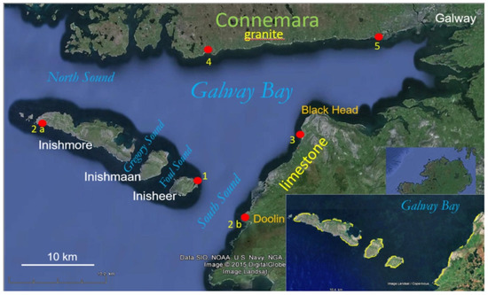
Figure 2.
Localities and methods for mid-Holocene sea-level reconstruction at −5 m mhw in Galway Bay and at the Aran Islands, central west coast of Ireland. 1—by micropaleontology in karst lake; 2a,b—by drowned soil with charcoal; 3—by drowned sand deposit for a now-inactive dune field; 4—by Bronze Age tomb in surf level; 5—by drowned freshwater peat with birch and oak and Neolithic canoe. Insert shows extension of boulder deposits (yellow lines) along the Aran Islands and the southeast coast of Galway Bay altogether for about 35 km.
Accordingly, there are some distinguishing features that are rather trivial but should nevertheless be kept in mind when making an assessment.
Coral reefs are a special case (in particular, fringing reefs) because of the sequence of forms from sea to land; the outer edge of the reef usually forms a step. Here, the surf breaks and can dislodge large fragments during extreme events. The production of boulders on the reef platform itself is rather low or mostly limited to coral rubble. The reef platform has a very low, often absent slope; its surface is rough with high friction (due to coral fragments or rubble, and less so with sand cover). With sufficient width (well over 1 km in many cases), all boulders can be deposited on this platform, no counter-slope has to be overcome during their transport, as is the case with almost all other coastal forms; thus, the setting is simple [10,19,33,73,83,116,148,149,153,154,155,156].
In this setting, calculations of energy turnover and the transport distance are usually strikingly large (by global standards). Moreover, transport against gravity is insignificant in models trying to replicate this setting. Particularly in recent storms, the landward decreasing size of boulders on reef platforms is highlighted as a key feature. This feature does not occur in recent tsunamis and is also usually absent on coastal slopes or cliffs rising from the sea (Figure 3).
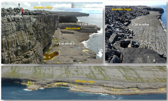
Figure 3.
Low and intermediate rock platforms of the Aran Islands usually are bare of sediments (aspects from Inishmore’s south coast).
A special feature of coral reef boulders is their irregular shape. Thus, spheres and platy boulders, which play a significant role in transport physics, are usually missing.
Time is always a crucial quantity in geology and geomorphology. In practical investigations, it must be considered in at least two relations, namely as the period of investigation with respect to extreme events, and the period of time covered by the deposits as a whole. The following considerations are important:
- -
- Is there a mention of on-time or near-time?
- -
- Is this recent (in the geological sense, Holocene) or related to “modern times” or a historical time span? The age question is often not mentioned at all.
- -
- If sea level is mentioned (mean high water or mean spring tide high water), its stable position for the younger Holocene is assumed, whereby an error of some meters can already occur. With a tidal range of 4.2 m, as is around the Aran Islands, there is already more than 2 m difference in elevation between mean sea level (usually the basis for elevation data in topographic maps) and the mean high-water line, which can be easily determined on rocky coasts by precisely measurable levels in the life zones, which already causes significant differences for transport processes and wave run-up.
- -
- Is the view and statement on the process clear, or is it using different terms—typically unclearly defined—such as normal storms, hurricane storms, “superstorms”, tsunamis, historical, or “paleo”? In relationship to the impact range of the hurricane storms off Ireland in the winter of 2013/2014, which clearly did not reach wide and high Coastal Bolder Deposit (CBD) formations at all, Cox [95] and Cox et al. [100,101] also refer to storms being much stronger “in the past”. Comparing the Aran boulders with Eemian giant boulders in the Bahamas [101], even “superstorms” are considered.
- -
- Is the aspect of the age of the boulder deposits addressed, and in what precision or on what data basis?
- -
- Does the question of a sea-level change during this period (quantitative, qualitative, significant, or unknown) arise from the chronology?
The development of publications as a reflection of research directions clearly proceeds in one direction: calculations vs. nature’s reality; that is, calculations tend to be favoured over nature. Calculations refer (if at all) to very limited scenarios (e.g., coastal slope, with or without platform, single blocks according to size/mass/orientation, etc.). In nature, such conditions can be traced for miles over changing topography, reliefs, exposures, deposits, etc., in all conceivable modifications of natural environments, including a comparison of boulders and blocks and fine sediments, for example. For the latter, there are typical and undoubted tsunami clues, including an erosional base, grading/upwards fining, mud cap, and/or mud clasts and chaotic structure, e.g., ”swimming” boulders in finer matrix.
Along rocky coastlines, scenarios are variable but offer several aspects for process reconstruction. These study area scenarios and considerations include the following:
- The area is well protected relative to wave action (storms, tsunamis, etc.), obstructed (e.g., in an island archipelago), or (strongly) exposed;
- Lower to higher gradients (straight, convex, concave, etc.) of a few degrees to about 25–30°, a shallow foreshore area, with or without significant amounts of sediment in the littoral zone;
- A cliff situation (e.g., deep water/plunging cliff, with or without basal platform, see Figure 3), with moderately steep cliff (>30° to >45°);
- A pronounced cliff situation up to vertical (or even overhanging);
- Certain fragments are made available to the incoming transport force, such as irregularly randomly shaped, rounded/massive fragments (e.g., from weathered crystalline rocks or a former ground moraine), or platy and erupted fragments from well-stratified sedimentary rocks on-site.
For accumulations of coarse material (boulders, Figure 4), only a few deposit types are listed in the literature: single/individual, groups, or cluster and ridges, which usually exhausts the list, although several are missing here because the geomorphological point of view on these deposits disappears far behind sedimentological questions: boulder ridges may have developed, e.g., from planar deposits by activation or erosion of the seaward sections (ABC islands of the Caribbean, Aran, and Galway Bay).
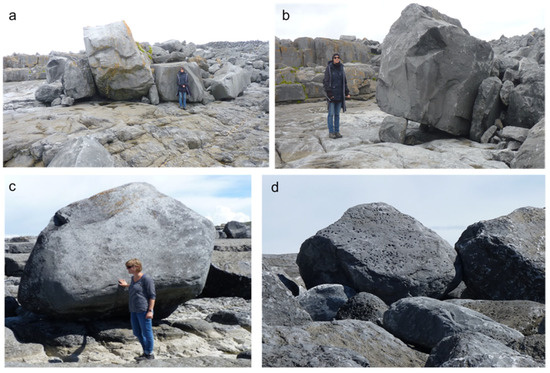
Figure 4.
(a,b) Boulders up to 40 tons in mass, activated and partly shifted by hurricane storm waves 2013/2014 at the south coast of Inishmore; (c,d) rounded boulders up to 20 tons from the tidal fringe (see Lithophaga borings in (d)) at the northwest coast of Inishmaan, where only refracted waves may impact.
Imbrication (Figure 5 and Figure 6) is occasionally mentioned; imbrication trains with a completely different genesis that is mostly overlooked—invoking the state of research so far—and ripple-ridges or boulder tongues seem to occur only in one place on Earth (Aran and Galway in the west of Ireland). Cox et al. [101] claim that there have been no direct observations of imbrication in recent tsunamis (documented in [137], among others, for the 2011 Japan tsunami) nor do tsunamis leave behind boulder ridges and boulder clusters. This is to support the claim that tsunamis have never occurred in the west of Ireland. Apparently, the authors are not aware that large submarine slides, which are possible tsunami triggers, were mapped in the past and partially dated in the 3000 m deep and steep Rockall Trough west of Ireland (compare [152]).
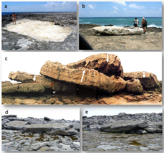
Figure 5.
Relation of boulder forms to transport energy: (a,b) lifting and overturning from hurricane waves 2004 on Bonaire (southern Caribbean); (c) imbrication train from partly overturned boulders (axes up to 9 m) at +10 m during the 1755 CE Lisbon Tsunami in Morocco; (d,e) platy boulders of 50+ tons at +9–11 m mhw and up to 200 m from the coastline at the SE coast of Inishmaan.
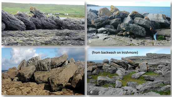
Figure 6.
(a–c) Massive imbrication of boulders up to 50 tons about 15 km inside Galway Bay along limited water depth where all storm waves >5 m today lose energy by ground touching. Incorporated boulders go back to 6000 cal BP, when sea level was 5 m lower as was wave energy; (d) landward dipping imbrication from backwash at around +10 m mhw and >100 m inland from the south coast of Inishmore.
Any study that uses coastal boulders as evidence for the reconstruction of a specific transport process must evaluate their properties, origin, and age amongst other environmental parameters. As long as this transport is dominated by a downward movement, even if it happens slowly on a very small gradient, it may be gravitational for an extended time. Such boulders are unsuitable for any kind of calculation of storm wave or tsunami transport. The term “moved boulders” is equally imprecise and, therefore, useless. If one takes these as an argument for the essentially unlimited transport capacity of storm waves to exclude tsunamis as an alternative process, they can be found in any size (e.g., [34,96,101]). Regrettably, this also introduces misconceptions into the media.
If, according to the terrain situation, it is undisputed that there has been a landward movement, the quantities for distances and against gravity are indispensable for any calculation, test runs, models, etc. A prerequisite for this, however, is the determination of the origin of a boulder, either originally, or before the last active movement (Figure 7).
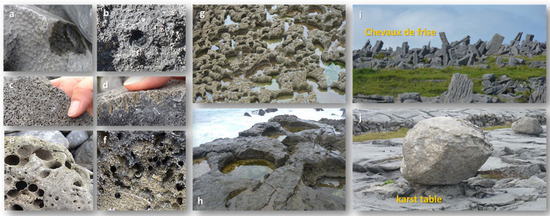
Figure 7.
(a–h): Bio-erosional signatures on bedrock and boulders allow for identification of their origin precisely: (a) sea urchin home places; (b) limpet (Patella sp.) home place; (c,d) sponge borings (Cliona sp.); (e,f) boring bivalves (Hiatella arctica); (g) rock pools with barnacle cover at mhw; (h) rock pools in supratidal position with 1–2 m diameter. The intensity of bio-erosion on dense limestone has been estimated at 1 mm/year. Calibration of weathering/dissolution intensity on limestone in a terrestrial environment is about 0.02–0.03 mm/year (=1 mm during 30–50 years). Tests may come from dimension of “karst tables“ under glacial erratics (exposed for about 15,000 years, see (j)) or from archaeological sites such as the Chevaux de Frise from a Bronze Age fortification dated to 2800 cal BP (see (i)).
This is both possible for boulders originating from the littoral or sublittoral belt (rounded/with organic attachments or bio-erosion traces) or for sedimentary rocks due to their subtle differences in stratigraphy. In most cases, this evidence is not available or even considered, making calculations of boulder dislocation type, character, and performance questionable. Herterich et al. [153] shed light on boulder production by hydraulic fracturing on cliffs and platforms. They hardly qualify as delivery areas for the extensive and high lying boulder deposits of the Galway and Aran Islands region; corresponding outcrops were only found at a few points after the 2013/2014 hurricanes (Figure 8), and the fragments mostly fell into the sea. Irregularly stepped rock formations, on the other hand, were injured somewhat more frequently, but most of the material was activated from existing block walls and, at heights above 10 m MHW, quite predominantly eroded and landed in the sea so that the cliff platforms are almost block-free (Figure 3). Moreover, they show hardly any traces of block movement even directly after the storms [122].
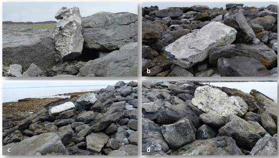
Figure 8.
Individual boulders from the tidal belt up to several tons in mass, covered by calcareous algae and balanids (all examples (a–d) from the coastal section inside Galway Bay, SE coast).
The seemingly simple question, how many steps a boulder has moved from its origin, is either to be recognized by chance or remains unknown. A relatively good overview of the total age of deposits or individual steps in them and the movements of sea level from which the acting forces started offer approaches to an estimate and should then be mentioned.
Little consideration is generally given to the source material (i.e., rock type) in boulder deposits, although it can provide very valuable insight into the environment of origin (e.g., from existing terrestrial deposits as an in situ product; from glacial, periglacial, fluvial sediments; from littoral or sublittoral sources) or weathering intensity and, thus, the (relative) age overall or at the last emplacement (see examples in [121]). Solid limestone in particular provides many approaches for inferences, including quite precise relative age dating as the difference in ablation intensity by rainwater solution on the one hand (around 0.02–0.03 mm/year) and biogenic ablation by littoral organisms (around and >1 mm/year) on the other (see Figure 7). Typical littoral forms at/on boulders such as rock pools or biogenic traces such as boreholes, habitats, and attachments also allow a precise determination of the area of origin and, thus, the transport path and especially against gravity. All coastal deposits are subjected to simple laws for their preservation, addition, or disappearance. These are variations in sea level, availability of (additional) material, and conditions for preservation. These may lead to different results between flat and low coastal landscapes and those sloping toward the sea.
Each extreme event has a spatially unusual wide range landward of the coastline (compared to frequently occurring process strengths). To infer the process from a boulder distribution, especially the difference between storm and tsunami, is therefore risky for a very limited space (e.g., a small low island), because there is no test possibility to check how the water would have moved and spread with the event in question and provide higher relief. In diverse coastal landscapes, topography and relief (such as the Aran Islands and Galway Bay) make it possible because terrain features can be traced and tested in any direction for more than 40 km.
In contrast to most depositional storm- and tsunami-induced mechanisms described, the 2013/2014 hurricanes in the Galway/Aran area, as a paradox, have overall been destructive in nature (Figure 9), mostly along an envelope of existing boulder formations, which are rare at cliffs and on platforms.

Figure 9.
South coast of Inisheer after the hurricane storms of winter 2013/2014, the strongest storms on registration and in living memory, at highest postglacial sea level. Black frames mark activation (mostly erosion) at the seaward ridge slope; white frames mark boulder clusters remaining immobile, although in full storm wave attacks. All elevations shown are below +10 m mhw (compare with Figure 10). (a)—southwest exposure; (b)—southeast exposure.
Few individual boulders have been broken from bedrock and moved inland against gravity; existing small boulders locally were activated at ridge bases and seaward slopes, but the larger boulders are often left immobile in the storm-wave attack zone (Figure 10), and no fine sediments can be detected. As a result, these strongest storms on record at the central west coast of Ireland are hardly identifiable after decades and certainly not after centuries, meaning that they will not obtain their orderly place in paleo-event catalogues. The main reason is that they did not leave geomorphologic signatures in hard rock.
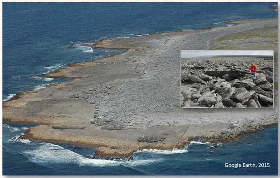
Figure 10.
Main boulder “ridge“ on Inisheer with landward slopes of low or no inclination and fields of boulders strewn inland. Along its seaward base, enrichments of large, mostly immobile boulders document the slow erosional tendency of the main formation (compare Figure 11).
If the opportunity arises for a direct before-and-after study or there is an eyewitness to a process that undoubtedly unleashes an energy unprecedented in a particular location/region, such as the hurricanes in western Europe in late 2013/early 2014 or Hurricane Hayan 2013 in the Philippines [110,141], the boulder distribution requiring a significantly higher energy level (as in the Aran/Galway region) and a higher sea level at times of older dislocation can be safely excluded; the conclusion on the tsunami effects is, thus, not only obvious, the boulder distribution compellingly extends significantly beyond the hurricane’s range [102].
Tsunamis as a relevant factor (in addition to storm waves) must be considered, if deposits occur outside the strongest storm wave envelopes of the last centuries or modern times (Figure 11), based on the age of deposits, sea-level position during past events, and other observations from a wider landscape such as tsunamigenic key features in fine sediment archives (Figure 12 and Figure 13) close to boulder sites.
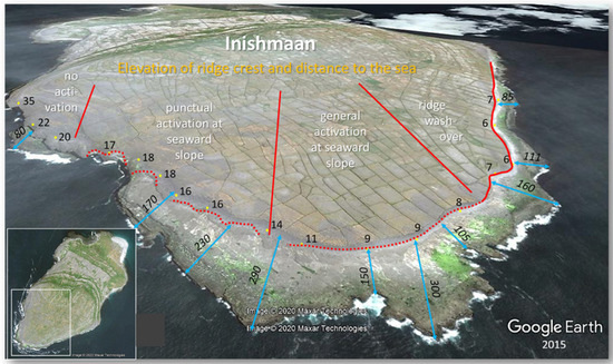
Figure 11.
“Envelope“ of strongest storms on registration (hurricanes of winter 2013/2014) at the highest Holocene sea level along the southwest coast of Inishmaan, marked in boulder deposits emplaced during past extreme events from a significant lower sea level.
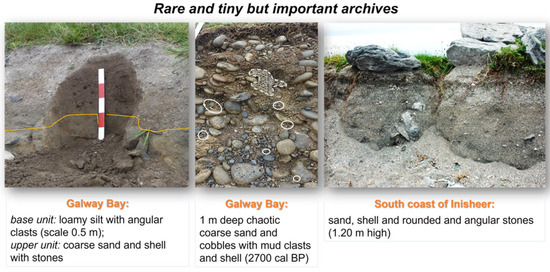
Figure 12.
Chaotic (non-sorted) coastal deposits that are unusual in storm-wave dominated environments.
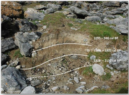
Figure 13.
Strata with basal erosional unconformity that are graded with upward fining. Ages point to different events (about 20 km inside Galway Bay at its southeast coastline) [65,125].
All these points and numerous others need to be examined whenever theories, models, tests, generalizations, etc., are presented, either as a theoretical approach without reference to a case from reality or in relation to a natural situation as the basis for a global judgment [157,158,159,160,161,162,163,164,165,166,167,168,169].
Moreover, under no circumstances should natural evidence be overlooked or disregarded in the setting that clearly contradicts the conclusions drawn from calculations for a very limited space. Thus, as Oetjen et al. [166] wrote, “authors found an astonishing difference in transport distance, transport modes, and relation to boulder forms and velocities from published tests”, although nature’s varieties have been strongly reduced and simplified. In their test device, and “in the present study, overturning of the boulder occurred only in three of over 600 experimental runs, and even in those cases the boulder was overturned only once and then transported further by sliding”.
Watanabe et al. [137], in Conclusions, p. 633, observe that “hydraulic parameters estimated from boulder-transport models entail much uncertainty because the models have been developed based on numerous assumptions related to simplifications of actual phenomena”.
2.4. Main Points Remaining for Further Discussion
- There is no accepted/general methodological approach to study coastal boulders in terms of their relocation process, not even agreement on what easily ascertainable parameters of arguments, statements, facts, and data sets could yield, such as size, mass, shape, rounding, altitude, distance to water, horizontal and vertical transport routes, determination of origin, bedding type, bedding pattern (Figure 14), age indications and age determination, influence of coastal shape, bathymetry, coastal relief, rock type, and others.
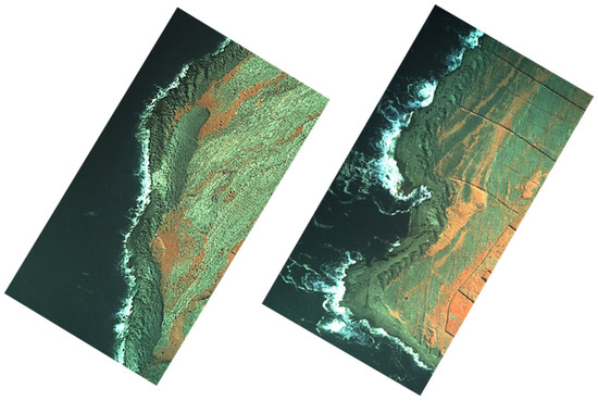 Figure 14. Left: 130 m long overwash boulder tongue 22 km inside Galway Bay, dated to about 5000 cal BP, with sharp outer contours, pushed ashore almost instantaneously during a lower sea level from a (littoral to sublittoral) deposit of well-rounded cobbles and small boulders (total mass about 10,000 tons). Right: 500 m long section of rhythmic crossway ripple ridges (height of 2–3 m) decorating the main boulder belt on a cliff top platform at +10 m mhw from the southern entrance to Galway Bay at Doolin Point northwards.
 - For fine sediments, stratigraphy and chronology are standard. For coarse material, stratigraphy mostly does not exist, and chronology is difficult to ascertain for single events, which may leave a mixture of fragments of very different ages. A chronology of transport events is even difficult to establish in coral rubble, as almost certainly the age will reflect its first dislocation from the living position, which mostly is not the age of the last storm- or tsunami-induced movement to landward.
- For boulders, stratigraphy seems to be missing (but is certainly present in the type of imbrication) in relation to the fine material character in close proximity or at least by relative and numerical ages determined for the units of the deposits (almost never studied in parallel).
- The question of the exposure of the coast is often not asked, the relief is rarely taken into account, and the water depth in the critical near-shore area not checked.
- In judging the main process—storm waves or tsunamis as extreme events—there is often a lack of focus on the effect of recent times (e.g., the effect of the strongest young storms to date) as a data provider for known process and effect variables.
- Since the age of the deposits has only been sufficiently determined in a few cases, there is also a lack of information on sea levels (associated with the deposits through time).
- In the case of a statement for or against only being a storm or tsunami, there is usually no cross-check to ascertain whether this statement remains valid or is supported when examining closer surroundings (e.g., in different exposure/relief/bathymetry).
3. Conclusions
In geosciences, securing facts according to quantity and quality and their validation on the basis of process relationships with each other is needed; these are supplied by nature itself.
Substantive criticism must address the arguments presented, prove them to be false or erroneous, or offer further convincing correlations. This requires a view of a somewhat larger and, in terms of natural endowment, rich area, which is especially true concerning extreme processes, because these are not limited to small localities. The natural processes of the past have their own fixed reality, whether we recognize and acknowledge them or misinterpret or deny them. They remain what they have been (as far as we can recognize). Contradictory views in scientific debates often drive progress and enrich the search for new knowledge of reality because they could lead to new methods of conducting research. The reality in nature alone decides whether a finding, an idea, or an assumption comes close to it or even represents it completely or just remains an attempt of approximation. An approximation in these ways can, therefore, be successful, even in small steps, as long as the conclusions drawn from it stand up to scrutiny in nature. In a natural landscape, there are no majority opinions, but only the reality onsite (with site and time documented), which is verifiable at any time. Subjective preconceptions and prejudices do not help. The reality of nature in all its diversity can hardly be reproduced to scale in experiments or models, because these experiments and models have simplifications and, thus, margins of error in every single step.
As long as the conclusions can be combined without contradiction, there is the greatest probability of correctly identifying the responsible processes or of having progressed towards a path to the solution. If important parameters of nature are replaced by simplified assumptions, at best, artificial border statements result in a standard synopsis of nature, however, and not for its reality in space. Thereby, changes of nature during time are not yet recorded.
Scientific originality and progress in geosciences are hardly the elucidation of further calculation steps and imitations but involve the ability to see, recognize, classify, and compare reality in nature and to draw conclusions that must not contradict each other at any point, especially when carrying out paleo-tsunami research as a basis for safety and protection measures against this force of nature. In short, there needs 16ob e more collaboration between geologists and hydrodynamical modelers. Otherwise, the conclusions based on numerical modeling can be tenuous at best.
Author Contributions
All authors (A.S., W.E.) have agreed to the conceptualization, formal analysis writing, and review/editing of the manuscript. All authors have read and agreed to the published version of the manuscript.
Funding
This research received no external funding.
Institutional Review Board Statement
Not applicable.
Informed Consent Statement
Not applicable.
Conflicts of Interest
The authors declare no conflict of interest.
References
- Prendergast, A.L.; Cupper, M.L.; Jankaew, K.; Sawai, Y. Indian Ocean tsunami recurrence from optical dating of tsunami sand sheets in Thailand. Mar. Geol. 2012, 295–298, 20–27. [Google Scholar] [CrossRef]
- Cox, D.; Mink, J.F. The Tsunami of 23 May 1960 in the Hawaiian Islands. Bull. Seismol. Soc. Am. 1963, 53, 1191–1209. [Google Scholar] [CrossRef]
- Costa, P.J.M.; Andrade, C.; Freitas, M.C.; Oliveira, M.A.; da Silva, C.M.; Omira, R.; Taborda, R.; Baptista, M.A.; Dawson, A.G. Boulder deposition during major tsunami events. Earth Surf. Processes Landf. 2011, 36, 2054–2068. [Google Scholar] [CrossRef]
- Dominey-Homes, D. Post-event field surveys. In Geological Records of Tsunamis and Other Extreme Waves; Engel, M., Pilarczyk, J., May, S.M., Brill, D., Garrett, E., Eds.; Elsevier: Amsterdam, The Netherlands, 2020; pp. 185–212. [Google Scholar]
- Etienne, S.; Buckley, M.; Paris, R.; Nandasena, A.K.; Clark, K.; Strotz, L.; Chague’-Goff, C.; Goff, J.; Richmond, B. The use of boulders for characterising past tsunamis: Lessons from the 2004 Indian Ocean and 2009 South Pacific tsunamis. Earth-Sci. Rev. 2011, 107, 76–90. [Google Scholar] [CrossRef]
- Goto, K.; Sugawara, D.; Ikema, S.; Miyagi, T. Sedimentary processes associated with sand and boulder deposits formed by the 2011 Tohoku-oki tsunami at Sabusawa Island, Japan. Sediment. Geol. 2012, 282, 188–198. [Google Scholar] [CrossRef]
- Goto, K.; Fujima, K.; Sugawara, D.; Fujino, S.; Imai, K.; Tsudaka, R.; Abe, T.; Haraguchi, T. Field measurements and numerical modeling for the run-up heights and inundation distances of the 2011 Tohoku-oki tsunami at Sendai Plain, Japan. Earth Planets Space 2012, 64, 1247–1257. [Google Scholar] [CrossRef] [Green Version]
- Kelletat, D. Naturgefahren, Naturkatastrophen. In Grundwissen Geografie bis zur 10.Klasse; Bartels, G., Kelletat, D., Schäbitz, F., Selbach, V., Thieme, G., Eds.; Mentor Verlag: München, Germany, 2006; pp. 238–247. [Google Scholar]
- Komatsu, G.; Goto, K.; Baker, V.R.; Oguchi, T.; Hayakawa, Y.S.; Saito, H.; Pelletier, J.D.; McGuire, L.; Iijima, Y. Effects of Tsunami Wave Erosion on Natural Landscapes: Examples from the 2011 Tohoku-oki Tsunami. In Tsunami Events and Lessons Learned; Kontar, Y., Santiago-Fandiño, V., Takahashi, T., Eds.; Springer: Dordrecht, The Netherlands, 2014; pp. 243–253. [Google Scholar] [CrossRef]
- Shiki, T.; Tsuji, Y.; Yamazaki, T.; Minoura, K. (Eds.) Tsunamiites. Features and Implications; Elsevier: Amsterdam, The Netherlands, 2008; p. 411. [Google Scholar]
- Simkin, T.; Fiske, R.S. Krakatau 1883: The Volcanic Eruption and Its Effects; Smithsonian Institution Press: Washington, DC, USA, 1983; p. 464. [Google Scholar]
- Abad, M.; Izquierdo, T.; Caceres, M.; Bernardez, E.; Rodriguez-Vidal, J. Coastal boulder deposit as evidence of an ocean-wide prehistoric tsunami originated on the Atacama Desert coast (northern Chile). Sedimentology 2020, 67, 1505–1528. [Google Scholar] [CrossRef]
- Bondevik, S.; Svendsen, J.I.; Johnsen, G.; Mangerud, J.; Kaland, P.E. The Storegga tsunami along the Norwegian coast, its age and runup. Boreas 1997, 26, 29–53. [Google Scholar] [CrossRef]
- Bugge, T.; Belderson, R.H.; Kenyon, N.H. The Storegga Slide: Philosophical Transactions of the Royal Society of London. Ser. A 1988, 325, 357–388. [Google Scholar]
- Carey, S.; Morelli, D.; Sigurdsson, H.; Bronto, S. Tsunami deposits from major explosive eruptions: An example from the 1883 eruption of Krakatau. Geology 2001, 29, 347–350. [Google Scholar] [CrossRef]
- Dawson, A.G.; Long, D.; Smith, D.E. The Storegga Slides: Evidence from eastern Scotland for a possible tsunami. Mar. Geol. 1988, 82, 271–276. [Google Scholar] [CrossRef]
- Frohlich, C.; Hornbach, M.; Taylor, F.; Shen, C.; Moala, A.; Morton A und Kruger, J. Huge erratic boulders in Tonga deposited by a prehistoric tsunami. Geology 2009, 37, 131–134. [Google Scholar] [CrossRef] [Green Version]
- Goto, K.; Miyagi, K.; Kawamata, H.; Imamura, F. Discrimination of boulders deposited by tsunamis and storm waves at Ishigaki Island, Japan. Mar. Geol. 2010, 269, 34–45. [Google Scholar] [CrossRef]
- Goto, T.; Satake, K.; Sugai, T.; Ishibe, T.; Harada, T.; Murotani, S. Historical tsunami and storm deposits during the last five centuries on the Sanriku coast, Japan. Mar. Geol. 2015, 367, 105–117. [Google Scholar] [CrossRef]
- Harbitz, C.B. Model Simulations of Tsunamis Generated by the Storregga Slide; Institute of Mathematics, University of Oslo: Oslo, Norway, 1991; Volume 5, p. 30. [Google Scholar]
- Latter, J.H. Tsunami of Volcanic Origin: Summary of Causes, with Particular Reference to Krakatoa, 1883. Bull. Volcanol. 1981, 44, 467–490. [Google Scholar] [CrossRef]
- Bryant, E. Tsunami: The Underrated Hazard; Cambridge University Press: Cambridge, UK, 2001; p. 320. [Google Scholar]
- Bryant, E. Tsunami: The Underrated Hazard, 2nd ed.; Springer: Berlin/Heidelberg, Germany, 2008; p. 330. [Google Scholar]
- Bryant, E. Tsunami: The Underrated Hazard, 3rd ed.; Springer: Cham, Switzerland, 2014; 222p. [Google Scholar] [CrossRef]
- Engel, M.; May, S.M.; Pilarczyk, J.; Brill, D.; Garrett, E. Geological records of tsunamis and other extreme waves: Concepts, applications and a short history of research. In Geological Records of Tsunamis and Other Extreme Waves; Engel, M., Pilarczyk, J., May, S.M., Brill, D., Garrett, E., Eds.; Elsevier: Amsterdam, The Netherlands, 2020; pp. 3–20. [Google Scholar]
- UNESCO. Tsunami Glossary. A Glossary of Terms and Acronyms Used in the Tsunami Literature. Technical Series, 37. 1991. Available online: http://itic.ioc-unesco.org/index.php?option=com_content&view=article&id=1328&Itemid=1142&lang=en (accessed on 20 January 2022).
- Dawson, A.G. The geological significance of tsunamis. Z. Geomorphol. NF 1996, 102, 199–210. [Google Scholar]
- Dawson, A.G.; Stewart, I. Tsunami deposits in the geological record. Sediment. Geol. 2007, 200, 166–183. [Google Scholar] [CrossRef]
- Dawson, A.G.; Shi, S. Tsunami deposits. Pure Appl. Geophys. 2000, 157, 875–897. [Google Scholar] [CrossRef]
- Engel, M.; Pilarczyk, J.; May, S.M.; Brill, D.; Garrett, E. (Eds.) Geological Records of Tsunamis and Other Extreme Waves; Elsevier: Amsterdam, The Netherlands, 2020; p. 816. [Google Scholar]
- Gusiakov, V.K. Tsunami History: Recorded. In The Sea Tsunamis; Harvard University Press: Cambridge, UK, 2009; pp. 23–53. [Google Scholar]
- Lau, A.Y.A.; Autret, R. Spatial patterns of subaerial coarse clasts. In Geological Records of Tsunamis and Other Extreme Waves; Engel, M., Pilarczyk, J., May, S.M., Brill, D., Garrett, E., Eds.; Elsevier: Amsterdam, The Netherlands, 2020; pp. 513–546. [Google Scholar]
- Röbke, B.R.; Vött, A. The tsunami phenomenon. Prog. Oceanogr. 2017, 159, 296–322. [Google Scholar] [CrossRef]
- Scheffers, A. Tsunami boulder deposits. In Tsunamiites; Features and Implications; Shiki, T., Tsuji, Y., Yamazaki, T., Minoura, K., Eds.; Elsevier: Amsterdam, The Netherlands, 2008; pp. 299–318. [Google Scholar]
- Scheffers, A. Paleotsunami Research-Current Debate and Controversies. In Coastal and Marine Hazards, Risks, and Disasters, 1st ed.; Ellis, J., Sherman, D., Eds.; Elsevier: Amsterdam, The Netherlands, 2014; pp. 59–92. [Google Scholar]
- Scheffers, A. Tsunami boulder deposits—A strongly debated topic in paleo-tsunami research. In Tsunamiites, 2nd ed.; Shiki, T., Tsuji, Y., Yamazaki, T., Nanayama, F., Eds.; Features and Implications; Elsevier: Amsterdam, The Netherlands, 2020; pp. 353–381. [Google Scholar]
- Sugawara, D.; Minoura, K.; Imamura, F. Tsunamis and Tsunami Sedimentology. In Tsunamiites; Elsevier: Amsterdam, The Netherlands, 2008; pp. 9–49. [Google Scholar]
- Terry, J.P.; Annie Lau, A.Y.; Etienne, S. Reef-Platform Coral Boulders–Evidence for High-Energy Marine Inundation Events on Tropical Coastlines; Springer Briefs in Geography; Springer: Dordrecht, The Netherlands, 2013; p. 105. [Google Scholar]
- Ambraseys, N.; Synolakis, C.E. Tsunami Catalogs for the Eastern Mediterranean, Revisited. J. Earthq. Eng. 2010, 14, 309–330. [Google Scholar] [CrossRef]
- Cheng, S.; Zeng, J.; Liu, H. A Comprehensive Review of the Worldwide Existing Tsunami Databases. J. Earthq. Tsunami 2019, 14, 2040003. [Google Scholar] [CrossRef]
- Cox, D.C.; Pararas-Carayannis, G. Catalog of Tsunamis in Alaska Revised 1976; Report SE-1; World Data Center A, NOAA: Boulder, CO, USA, 1976; p. 43.
- Fernandez, M.; Molina, E.; Haskov, J.; Atakan, K. Tsunami and Tsunami Hazards in Central America. Nat. Hazards 2000, 22, 91–116. [Google Scholar] [CrossRef]
- Goff, J. Tsunami databases. In Geological Records of Tsunamis and Other Extreme Waves; Engel, M., Pilarczyk, J., May, S.M., Brill, D., Garrett, E., Eds.; Elsevier: Amsterdam, The Netherlands, 2020; pp. 75–94. [Google Scholar]
- Gusiakov, V.K. Global Occurrence of Large Tsunamis and Tsunami-like Waves Within the Last 120 years (1900–2019). Pure Appl. Geophys. 2020, 177, 1261–1266. [Google Scholar] [CrossRef]
- Heck, N.H. List of seismic seawaves. Bull. Seismol. Soc. Am. 1947, 37, 269–286. [Google Scholar] [CrossRef]
- Iida, K.; Cox, D.C.; Pararas-Carayannis, G. Preliminary Catalogue of Tsunamis Occurring in the Pacific Ocean; Data Report Nr. 5; University of Hawaii: Honolulu, HI, USA, 1967. [Google Scholar]
- Lander, J.F. Tsunamis Affecting Alaska 1737–1996; NGDC Key to Geophysical Record Documentation No. 31; NOAA: Washington, DC, USA, 1996; p. 195.
- Lander, J.F.; Lockridge, P.A. United States Tsunamis (including United States Possessions) 1690–1988; NOAA/National Geophysical Data Center: Boulder, CO, USA, 1989; Volume 41.
- Lander, J.F.; Lockridge, P.A. United States Tsunamis (including United States Possessions) 1690–1988; NOAA/National Geophysical Data Center: Boulder, CO, USA, 1989; Volume 42.
- Lander, J.F.; Lockridge, P.A.; Kozuch, M.J. Tsunamis affecting the West Coast of the United States, 1806–1992; United States Department of Commerce: Boulder, CO, USA, 1993.
- Maramai, A. Historical records: Their importance in understanding and mitigating tsunamis. In Geological Records of Tsunamis and Other Extreme Waves; Engel, M., Pilarczyk, J., May, S.M., Brill, D., Garrett, E., Eds.; Elsevier: Amsterdam, The Netherlands, 2020; pp. 21–32. [Google Scholar]
- Nakata, T.; Kawana, T. Historical and prehistorical large tsunamis in the southern Ryukyus, Japan. In Proceedings of the Tsunamis ’93, Wakayama, Japan, 23–27 August 1993; Springer: The Hague, The Netherlands, 1993; pp. 297–307. [Google Scholar]
- Neely, W. The Greatest and Deadliest Hurricanes of the North Atlantic; URLink Print and Media: Cheyenne, WY, USA, 2019; p. 502. [Google Scholar]
- Papadopoulos, G.A.; Chalkis, B.J. Tsunamis observed in Greece and the surrounding area from antiquity up to present times. Mar. Geol. 1984, 56, 309–317. [Google Scholar] [CrossRef]
- Pararas-Carayannis, G. Catalog of Tsunamis in the Hawaiin Islands; Report WDCA-T 69-2; ESSA-Coast and Geodetic Survey: Boulder, CO, USA, 1969; p. 94. [Google Scholar]
- Soloviev, S.L. Recurrence of tsunamis in the Pacific. In Tsunamis in the Pacific Ocean: 149–164; Adams, W.M., Ed.; University of Hawaii: Honolulu, HI, USA, 1970. [Google Scholar]
- Soloviev, S.L.; Solovieva, O.N.; Go Ch, N.; Kim, K.S.; Shchetnikov, N.A. Tsunamis in the Mediterranean Sea 2000 B.C.–2000 A.D.; Kluwer Academic Publishers: Dordrecht, The Netherlands, 2000; p. 237. [Google Scholar]
- Antonopoulos, J. The great Minoan eruption of Thera volcano and the ensuing tsunami in the Greek Archipelago. Nat. Hazards 1992, 5, 153–168. [Google Scholar] [CrossRef]
- Aydar, E.; Çiner, A.; Ersoy, O.; Écochard, E.; Fouache, E.G. Volcanic ash and tsunami record of the Minoan Late Bronze Age Eruption (Santorini) in a distal setting, southwestern Turkey. J. Quat. Sci. 2021, 36, 586–597. [Google Scholar] [CrossRef]
- Paris, R.; Naylor, L.A.; Stephenson, W.J. Boulders as a signature of storms on rock coasts. Mar. Geol. 2011, 283, 1–11. [Google Scholar] [CrossRef]
- Mader, C.L.; Gittings, M.L. Numerical model for the Krakatoa hydrovolcanic explosion and tsunami. Sci. Tsunami Hazards 2006, 24, 174–182. [Google Scholar]
- Pararas-Carayannis, G. Near and far-field effects of tsunamis generated by the paroxysmal eruptions, explosions, caldera collapses and massive slope failures of the Krakatau volcano in Indonesia on August 26–27, 1883. Sci. Tsunami Hazards 2003, 21, 191–201. [Google Scholar]
- Araoka, D. Radiocarbon and U/Th dating of tsunami- and storm-transported coarse clasts. In Geological Records of Tsunamis and Other Extreme Waves; Engel, M., Pilarczyk, J., May, S.M., Brill, D., Garrett, E., Eds.; Elsevier: Amsterdam, The Netherlands, 2020; pp. 687–704. [Google Scholar]
- Jankaew, K.; Atwater, B.F.; Sawai, Y.; Choowong, M.; Martin, M.E.; Prendergast, A. Medieval forewarning of the 2004 Indian Ocean tsunami in Thailand. Nature 2008, 455, 1228–1231. [Google Scholar] [CrossRef]
- Erdmann, W.; Scheffers, A.M.; Kelletat, D.H. Holocene Coastal Sedimentation in a Rocky Environment: Geomorphological Evidence from the Aran Islands and Galway Bay (Western Ireland). J. Coast. Res. 2018, 34, 772–793. [Google Scholar] [CrossRef]
- O’Brien, L.; Renzi, E.; Dudley, J.D.; Clancy, C.; Dias, F. Catalogue of extreme wave events in Ireland: Revised and updated for 14 680 BP to 2017. Nat. Hazards Earth Syst. Sci. 2018, 18, 729–758. [Google Scholar] [CrossRef] [Green Version]
- Radtke, U.; Schellmann, G.; Scheffers, A.; Kelletat, D.; Kromer, B.; Kasper, H.U. Electron spin resonance and radiocarbon dating of coral deposited by Holocene tsunami events on Curaçao, Bonaire and Aruba (Netherlands Antilles). Quat. Int. 2002, 22, 1309–1315. [Google Scholar] [CrossRef]
- Rixhon, G.; May, S.M.; Engel, M.; Mechernich, S.; Schroeder-Ritzrau, A.; Fohlmeister, J.; Frank, N.; Boulvain, F.; Dunai, T.; Brückner, H. Multiple dating approach (14C, 230Th/U and 36Cl) of tsunami-transported reef-top boulders on Bonaire (Leeward Antilles) current achievements and challenges. Mar. Geol. 2018, 396, 100–113. [Google Scholar] [CrossRef]
- Scheffers, A. Tsunami imprints on the Leeward Netherlands Antilles (Aruba, Curacao and Bonaire) and their relation to other coastal problems. Quat. Int. 2004, 120, 163–172. [Google Scholar] [CrossRef]
- Schellmann, G.; Radtke, U.; Scheffers, A.; Whelan, F.; Kelletat, D. ESR dating of coral reef terraces on Curaçao (Netherlands Antilles) with estimates of Younger Pleistocene sea level elevations. J. Coast. Res. 2004, 20, 947–957. [Google Scholar] [CrossRef]
- Nanayama, F.; Shigeno, K.; Satake, K.; Shimokawa, K.; Koitabashi, S.; Mayasaka, S.; Ishii, M. Sedimentary differences between 1993 Hokkaido-Nansei-Oki tsunami and 1959 Miyakijima typhoon at Tasai, southwestern Hokkaido, northern Japan. Sediment. Geol. 2000, 135, 255–264. [Google Scholar] [CrossRef]
- Bietak, M. Radiocarbon and the date of the Thera eruption. Antiquity 2014, 88, 277–282. [Google Scholar] [CrossRef]
- Brill, D.; Jankaew, K.; Neubauer, N.P.; Kelletat, D.; Scheffers, A.; Vött, A.; Brückner, H. Holocene coastal evolution of southwest Thailand—implications for the site-specific preservation of palaeotsunami deposits. Z. Geomorphol. 2014, 58, 273–303. [Google Scholar] [CrossRef]
- Darienzo, M.E.; Peterson, C.D. Magnitude and frequency of subduction-zone earthquakes along the northern Oregon coast in the past 3000 years. Or. Geol. 1995, 57, 3–12. [Google Scholar]
- Engel, M.; Brückner, H.; Messenzehl, K.; Konopczak, A.; Scheffers, A.; Scheffers, S.; Kelletat, D.; Schiotz, F.; Vött, A.; Willershäuser, T.; et al. Coastal stratigraphies of eastern Bonaire (Netherlands Antilles): New insights into the palaeo-tsunami history of the southern Caribbean. Sediment. Geol. 2010, 231, 14–30. [Google Scholar] [CrossRef]
- Masselink, G.; Castelle, B.; Scott, T.; Dodet, G.; Suanez, S.; Jackson, D.; Floch, F. Extreme wave activity during 2013/14 winter and morphological impacts along the Atlantic coast of Europe. Geophys. Res. Lett. 2016, 43, 2135–2143. [Google Scholar] [CrossRef]
- Morton, R.A.; Gelfenbaum, G.; Jaffe, B.E. Physical criteria for distinguishing sandy tsunami and storm deposits using modern examples. Sediment. Geol. 2007, 200, 184–207. [Google Scholar] [CrossRef]
- Vött, A.; Kelletat, D. Editorial: Holocene Palaeotsunami Landfalls and Neotectonic Dynamics in the Western and Southern Peloponnese (Greece). Z. Geomorphol. NF 2015, 59, 317. [Google Scholar]
- Autret, R.; Suanez, S.; Fichaut, B.S.; Etienne, S. Development of a typology of cliff-top storm deposits of the Reykjanes Peninsula (Iceland). Géomorphol. Relief Processes Environ. 2016, 22, 61–76. [Google Scholar] [CrossRef] [Green Version]
- Engel, M.; May, S.M. Bonaire’s boulder fields revisited: Evidence for Holocene tsunami impact on the Leeward Antilles. Quat. Sci. Rev. 2012, 54, 126–141. [Google Scholar] [CrossRef]
- Goto, K.; Chavanich, S.A.; Imamura, F.; Kunthasap, P.; Matsui, T.; Minoura, K.; Sugawara, D.; Yanagisawa, H. Distribution, origin and transport process of boulders deposited by the 2004 Indian Ocean tsunami at Pakarang Cape, Thailand. Sediment. Geol. 2007, 202, 821–837. [Google Scholar] [CrossRef]
- Kelletat, D.; Schellmann, G. Tsunamis on Cyprus—Field evidences and 14C dating results. Z. Geomorphol. 2002, 46, 19–34. [Google Scholar] [CrossRef]
- Kelletat, D.; Scheffers, A.; Scheffers, S. Holocene tsunami deposits on the Bahaman Islands of Long Island and Eleuthera. Z. Geomorphol. 2004, 48, 519–540. [Google Scholar] [CrossRef]
- Mhammdi, N.; Medina, F.; Kelletat, D.; Amahmou, M.; Aloussi, L. Large Boulders along the Rabat Coast (Morocco); Possible Emplacement by the November, 1st, 1755 A.D. Tsunami. Sci. Tsunami Hazards 2008, 27, 1–30. [Google Scholar]
- Mottershead, D.; Bray, M.; Soar, P.; Farres, P.J. Extreme waves events in the central Mediterranean: Geomorphic evidence of tsunami on the Maltese Islands. Z. Geomorphol. NF 2014, 58, 385–411. [Google Scholar] [CrossRef] [Green Version]
- Neubauer, N.-P.; Brill, D.; Brückner, H.; Kelletat, D.; Scheffers, S.; Vött, A. 5000 Jahre Tsunami-Geschichte am Kap Pakarang (Thailand). Coastline Rep. 2011, 17, 81–98. [Google Scholar]
- Scheffers, A. Sedimentary Impacts of Holocene Tsunami Events from the Intra Americas Seas and Southern Europe: A Review. Z. Geomorphol. 2006, 146, 7–37. [Google Scholar]
- Scheffers, A. Ripple marks in coarse tsunami deposits. Z. Geomorphol. 2006, 146, 222–232. [Google Scholar]
- Scheffers, A.M.; Kelletat, D.H. Megaboulder Movement by Superstorms–A Geomorphological Debate. J. Coast. Res. 2020, 36, 844–856. [Google Scholar] [CrossRef]
- Scicchitano, G.; Monaco, C.; Tortorici, L. Large boulder deposits by tsunami waves along the Ionian coast of south-eastern Sicily (Italy). Mar. Geol. 2007, 238, 75–91. [Google Scholar] [CrossRef]
- Whelan, F.; Kelletat, D. Boulder Deposits on the Southern Spanish Atlantic Coast: Possible Evidence for the 1755 AD Lisbon Tsunami. Sci. Tsunami Hazards 2005, 23, 25–38. [Google Scholar]
- Autret, R.; Dodet, G.; Fichaut, B.; Suanez, S.; David, L.; Leckler, F.; Ardhuin, F.; Ammann, J.; Grandjean, P.; Allemand, P.; et al. A comprehensive hydro-geomorphic study of cliff-top storm deposits on Banneg Island during winter 2013–2014. Mar. Geol. 2016, 382, 37–55. [Google Scholar] [CrossRef] [Green Version]
- Autret, R.; Dodet, G.; Suanez, S.; Roudaut, G.; Fichaut, B. Long-term variability of supratidal coastal boulder activation in Brittany (France). Geomorphology 2018, 304, 184–200. [Google Scholar] [CrossRef]
- Bourrouilh-Le Jan, F.G.; Talandier, J. Sédimentation et fracturation de haute énergie en milieu récifal: Tsunamis, ouragans et cyclones et leurs effets sur la sédimentologie et la géomorphologie d’un atoll: Motu et hoa, à Rangiroa, Tuamotu, Pacifique SE. Marine Geol. 1985, 67, 263–333. [Google Scholar] [CrossRef]
- Cox, R. Very large boulders were moved by storm waves on the west coast of Ireland in winter 2013–2014. Mar. Geol. 2018, 412, 217–219. [Google Scholar] [CrossRef]
- Cox, R.; Zentner, D.B.; Kirchner, B.J.; Cook, M.S. Boulder Ridges on the Aran Islands (Ireland): Recent Movements Caused by Storm Waves, Not Tsunamis. J. Geol. 2012, 120, 249–272. [Google Scholar] [CrossRef] [Green Version]
- Cox, R.; Lopes, W.A.; Jahn, K.I. Quantitative roundness analysis of coastal boulder deposits. Mar. Geol. 2017, 396, 114–141. [Google Scholar] [CrossRef]
- Cox, R.; Hearty, P.J.; Russell, D.; Edwards, K.R. Comparison of Coastal Boulder Deposits (Holocene Age) on Eleuthera, Bahamas, with Storm-Transported Boulders on Aran Islands, Ireland. In Geological Society of America, Abstracts with Programs; Paper No 103-9; GSA Annual Meeting: Denver, CO, USA, 2015; p. 48. [Google Scholar]
- Cox, R.; Jahn, K.L.; Watkins, O.G.; Cox, P. Extraordinary boulder transport by storm waves (west of Ireland, winter 2013–2014), and criteria for analysing coastal boulder deposits. Earth-Sci. Rev. 2018, 177, 623–636. [Google Scholar] [CrossRef]
- Cox, R.; O’Boyle, L.; Cytrynbaum, J. Imbricated coastal boulder deposits are formed by storm waves, and can preserve a long-term storminess record. Sci. Rep. 2019, 9, 10784. [Google Scholar] [CrossRef]
- Cox, R.; Ardhuin, F.; Dias, F.; Autret, R.; Beisiegel, N.; Earlie, C.S.; Hwerterich, J.G.; Kennedy, A.; Paris, R.; Raby, A.; et al. Systematic review shows that work done by storm waves can be misinterpreted as tsunami-related because commonly used hydrodynamic equations are flawed. Front. Mar. Sci. 2020, 7, 4. [Google Scholar] [CrossRef]
- Erdmann, W.; Kelletat, D.; Scheffers, A. Boulder Dislocation by Storms, with Scenarios from the Irish West Coast. Mar. Geol. 2018, 399, 1–13. [Google Scholar] [CrossRef]
- Etienne, S.; Paris, R. Boulder accumulations related to storms on the south coast of the Reykjanes Peninsula (Iceland). Geomorphology 2010, 114, 55–70. [Google Scholar] [CrossRef]
- Fichaut, B.; Suanez, S. Quarrying, transport and deposition of cliff-top storm deposits during extreme events: Banneg Island Brittany. Mar. Geol. 2011, 283, 36–55. [Google Scholar] [CrossRef]
- Goto, K.; Miyagi, K.; Kawana, T.; Takahashi, J.; Imamura, F. Emplacement and movement of boulders by known storm waves: Field evidence from the Okinawa Islands, Japan. Mar. Geol. 2011, 283, 66–78. [Google Scholar] [CrossRef]
- Hall, A.M.; Hansom, J.D.; Williams, D.M.; Jarvis, J. Distribution, geomorphology and lithofacies of cliff-top storm deposits: Exampes from the high energy coasts of Scotland and Ireland. Mar. Geol. 2006, 232, 131–155. [Google Scholar] [CrossRef]
- Hall, A.M.; Hansom, J.D.; Williams, D.M. Wave-emplaced coarse debris and megaclasts in Ireland and Scotland: Boulder transport in a high-energy littoral environment: A discussion. J. Geol. 2010, 118, 699–704. [Google Scholar] [CrossRef]
- Hansom, J.D.; Hall, A.M. Magnitude and frequency of extra-tropical North Atlantic cyclones: A chronology from cliff-top storm deposits. Quat. Int. 2009, 195, 42–52. [Google Scholar] [CrossRef]
- Hearty, P.J.; Tormey, B.R. Sea-level change and superstorms; geologic evidence from the last interglacial (MIS 5e) in the Bahamas and Bermuda offers ominous prospects for a warming Earth. Mar. Geol. 2017, 390, 347–365. [Google Scholar] [CrossRef]
- Kennedy, A.B.; Mori, N.; Yasuda, T.; Shimozono, T.; Tomiczek, T.; Donahue, A.; Shimura, T.; Imai, Y. Extreme block and boulder transport along a cliffed coastline (Calicoan Island, Philippines) during Super Typhoon Haiyan. Mar. Geol. 2017, 383, 65–77. [Google Scholar] [CrossRef] [Green Version]
- Kennedy, A.B.; Cox, R.; Dias, F. Storm waves may be the source of some “tsunami” coastal boulder deposits. Geophys. Res. Lett. 2021, 48, e2020GL090775. [Google Scholar] [CrossRef]
- Khan, S.; Robinson, E.; Rowe, D.A.; Coutou, R. Size and mass of shoreline boulders moved and emplaced by recent hurricanes, Jamaica. Z. Geomorphol. 2010, 54, 281–299. [Google Scholar] [CrossRef]
- May, S.M.; Enge, L.M.; Brill, D.; Cuadra, C.; Lagmay, A.M.F.; Santiago, J.; Suarez, J.K.; Reyes, M.; Brückner, H. Block and boulder transport in Eastern Samar (Philippines) during Supertyphoon Haiyan. Earth Surf. Dyn. 2015, 3, 739–749. [Google Scholar] [CrossRef] [Green Version]
- Minamidate, K.; Goto, K.; Watanabe, M.; Roeber, V.; Toguchi, K.; Sannoh, M.; Nakashima, Y.; Kan, H. Millennial scale maximum intensities of typhoon and storm wave in the northwestern Pacific Ocean inferred from storm deposited reef boulders. Sci. Rep. 2020, 10, 7218. [Google Scholar] [CrossRef]
- Rovere, A.; Casella, E.; Harris, D.L.; Lorscheid, T.; Nandasena, N.A.; Dyer, B.; Sandstrom, M.R.; Stocchi, P.; D’Andrea, W.J.; Raymo, M.E. Giant boulders and the last interglacial storm intensity in the North Atlantic. Proc. Natl. Acad. Sci. USA 2017, 114, 12144–12149. [Google Scholar] [CrossRef] [PubMed] [Green Version]
- Scheffers, A.; Scheffers, S. Documentation of the impact of hurricane Ivan on the coastline of Bonaire (Netherlands Antilles). J. Coast. Res. 2006, 22, 1437–1450. [Google Scholar] [CrossRef]
- Williams, D.M. Mechanisms of wave transport of megaclasts on elevated cliff-top platforms: Examples from western Ireland relevant to the storm wave versus tsunami controversy. Ir. J. Earth Sci. 2010, 28, 13–23. [Google Scholar]
- Biolchi, S.; Furlani, S.; Antonioli, F.; Baldassini, N.; Deguara, J.; Devoto, S.; Di Stefano, A.; Evans, J.; Gambin, T.; Gauci, R.; et al. Boulder accumulations related to extreme wave events on the eastern coast of Malta. Nat. Hazards Earth Syst. Sci. 2016, 16, 737–756. [Google Scholar] [CrossRef] [Green Version]
- Bryant, E.A.; Haslett, S.K. Catastrophic wave erosion, Bristol Channel, United Kingdom: Impact of tsunami? J. Geol. 2007, 115, 253–269. [Google Scholar] [CrossRef] [Green Version]
- Deguara, J.C.; Gauci, R. Evidence of extreme wave events from boulder deposits on the south-east coast of Malta (Central Mediterranean). Nat. Hazards 2017, 86, 543–568. [Google Scholar] [CrossRef]
- Erdmann, W.; Kelletat, D.; Scheffers, A.; Haslett, S.K. Origin and Formation of Coastal Boulder Deposits in Galway Bay and on the Aran Islands, Western Ireland; Springer Briefs in Geography; Springer: Dordrecht, The Netherlands, 2015; p. 125. [Google Scholar]
- Erdmann, W.; Kelletat, D.; Kuckuck, M. Boulder Ridges and Washover Features in Galway Bay, Western Ireland. J. Coast. Res. 2017, 33, 997–1021. [Google Scholar] [CrossRef]
- Furlani, S.; Biolchi, S.; Devoto, S.; Saliba, D.; Scicchitano, G. Large boulder along the NE Maltese coast: Tsunami or storm wave deposits? J. Coast. Res. 2011, 61, 470. [Google Scholar] [CrossRef]
- Goto, K.; Kawana, T.; Imamura, F. Historical and geological evidence of boulders deposited by tsunamis, southern Ryukyu Islands, Japan. Earth Sci. Rev. 2010, 102, 77–99. [Google Scholar] [CrossRef]
- Garrett, E.; Pilarczyk, J.E.; Brill, D. Preface to marine geology special issue: Geological Records of Extreme Wave Events. Mar. Geol. 2017, 396, 1–5. [Google Scholar] [CrossRef] [Green Version]
- Mastronuzzi, G.; Sanso, P. Boulder transport by catastrophic waves along the Ionian coast of Apulia (southern Italy). Mar. Geol. 2000, 170, 93–103. [Google Scholar] [CrossRef]
- Medina, F.; Mhammdi, N.; Chigner, A.; Akil, M.; Jaaidi, E.B. The Rabat and Larache boulder fields; new examples of high-energy deposits related to storms and tsunami waves in north-western Morocco. Nat. Hazards 2011, 59, 725–747. [Google Scholar] [CrossRef]
- Nott, J. Waves, coastal boulder deposits and the importance of the pre-transport setting. Earth Planet. Sci. Lett. 2003, 210, 269–276. [Google Scholar] [CrossRef]
- Nott, J.F. Tsunami or storm waves?—Determining the origin of a spectacular field of wave emplaced boulders using numerical storm surge and wave models and hydrodynamic transport equations. J. Coast. Res. 2003, 19, 348–356. [Google Scholar]
- Richmond, B.M.; Watt, S.; Buckley, M.; Jaffe, B.E.; Gelfenbaum, G.; Morton, R.A. Recent storm and tsunami coarse-clast deposits characteristics, southeast Hawaii. Mar. Geol. 2011, 283, 79–89. [Google Scholar] [CrossRef] [Green Version]
- Scheffers, S.R.; Scheffers, A.; Kelletat, D.; Bryant, E.A. The Holocene paleo-tsunami history of West Australia. Earth Planet. Sci. Lett. 2008, 270, 137–146. [Google Scholar] [CrossRef] [Green Version]
- Scheffers, A.; Kelletat, D.; Browne, T. Wave-emplaced coarse debris and mega-clasts in Ireland and Scotland: A contribution to the question of boulder transport in the littoral environment. In Proceedings of the 2nd International Tsunami Field Symposium, Ostuni, Italy, 22–28 September 2008; Volume 6, pp. 151–153. [Google Scholar]
- Scheffers, A.; Scheffers, S.; Kelletat, D.; Browne, T. Wave-emplaced coarse debris and megaclasts in Ireland and Scotland: Boulder transport in a high- energy littoral environment. J. Geol. 2009, 117, 553–573. [Google Scholar] [CrossRef]
- Scheffers, A.; Kelletat, D.; Scheffers, S. Wave emplaced coarse debris and megaclasts in Ireland and Scotland: Boulder transport in a high-energy littoral environment: A reply. J. Geol. 2010, 118, 705–709. [Google Scholar] [CrossRef]
- Scheffers, A.; Kelletat, D.; Haslett, S.K.; Scheffers, S.; Browne, T. Coastal boulder deposits in Galway Bay and the Aran Islands, western Ireland. Z. Geomorphol. 2010, 54, 247–279. [Google Scholar] [CrossRef]
- Shah-Hosseini, M.; Morhange, C.; Beni, A.N.; Marriner, N.; Lahijani, H.; Hamzeh, M.; Sabatier, F. Coastal boulders as evidence for high-energy waves on the Iranian coast of Makran. Mar. Geol. 2011, 290, 17–28. [Google Scholar] [CrossRef]
- Watanabe, M.; Goto, K.; Imamura, F. Reconstruction of transport modes and flow parameters from coastal boulders. In Geological Records of Tsunamis and Other Extreme Waves; Engel, M., Pilarczyk, J., May, S.M., Brill, D., Garrett, E., Eds.; Elsevier: Amsterdam, The Netherlands, 2020; pp. 617–640. [Google Scholar]
- Weiss, R. The mystery of boulders moved by tsunamis and storms. Mar. Geol. 2012, 295, 28–33. [Google Scholar] [CrossRef]
- Weiss, R.; Diplas, P. Untangling boulder dislodgement in storms and tsunamis: Is it possible with simple theories? Geochem. Geophys. Geosystems 2015, 16, 890–898. [Google Scholar] [CrossRef]
- Williams, D.M.; Hall, A.M. Cliff-top megaclast deposits of Ireland, a record of extreme waves in the North Atlantic—storms or tsunamis? Mar. Geol. 2004, 206, 101–117. [Google Scholar] [CrossRef]
- Engel, M.; May, S.M.; Beill, D.; Reyes, M.; Brückner, H. Storm Surge of Supertyphoon Haiyan (7–9 November 2013) on Samar (Philippines) Moved the Largest Boulder Ever Documented for a Recent Storm. In Proceedings of the AGU Fall Meeting Abstracts, San Francisco, CA, USA, 15–19 December 2014; Volume 2014, p. NH21A–3824. Available online: https://agu.confex.com/agu/fm14/meetingapp.cgi (accessed on 22 January 2022).
- Kelletat, D.; Engel, M.; May, S.M.; Erdmann, W.; Scheffers, A.; Brückner, H. Erosive impact of tsunami and storm waves on rocky coasts and post-depositional weathering of coarse-clast deposits. In Geological Records of Tsunamis and Other Extreme Waves; Engel, M., Pilarczyk, J., May, S.M., Brill, D., Garrett, E., Eds.; Elsevier: Amsterdam, The Netherlands, 2020; pp. 561–584. [Google Scholar]
- Lau, A.Y.A.; Etienne, S.; Terry, J.P.; Switzer, A.D.; Lee, Y.S. A preliminary study of the distribution, sizes and orientations of large reef-top coral boulders deposited by extreme waves at Makemo Atoll, French Polynesia. J. Coast. Res. 2014, 70, 272–277. [Google Scholar]
- Lau, A.Y.A.; Terry, J.P.; Ziegler, A.D.; Switzer, A.D.; Lee, Y.; Etienne, S. Understanding the history of extreme wave events in the Tuamotu Archipelago of French Polynesia from large carbonate boulders on Makemo Atoll, with implications for future threats in the central South Pacific. Marine Geology 2016, 380, 174–190. [Google Scholar] [CrossRef]
- Nandasena, N.A.K.; Paris, R.; Tanaka, N. Reassessment of hydrodynamic equations: Minimum flow velocity to initiate boulder transport by high energy events (storms, tsunamis). Mar. Geol. 2011, 281, 70–84. [Google Scholar] [CrossRef]
- Piscitelli, A.; Milella, M.; Hippolyte, J.-C.; Shah-Hosseini, M.; Morhange, C.; Mastronuzzi, G. Numerical approach to the study of coastal boulders: The case of Martigues, Marseille, France. Quat. Int. 2017, 439, 52–64. [Google Scholar] [CrossRef]
- Scheffers, A.; Kelletat, D.; Vött, A.; May, M.; Scheffers, S. Late Holocene tsunami traces on the western and southern coastlines of the Peloponnesus (Greece). Earth Planet. Sci. Lett. 2008, 269, 271–279. [Google Scholar] [CrossRef]
- Goto, K.; Okada, K.; Imamura, F. Characteristics and hydrodynamics of boulders transported by storm waves at Kudaka Island, Japan. Mar. Geol. 2009, 262, 14–24. [Google Scholar] [CrossRef]
- Hisamatsu, A.; Goto, K.; Imamura, F. Local paleo-tsunami size evaluation using numerical modeling for boulder transport at Ishigaki Island, Japan. Episodes 2014, 37, 265–275. [Google Scholar] [CrossRef] [PubMed] [Green Version]
- Nandasena, N.A.K. Perspective of incipient motion formulas:boulder transport by high-energy waves. In Geological Records of Tsunamis and Other Extreme Waves; Engel, M., Pilarczyk, J., May, S.M., Brill, D., Garrett, E., Eds.; Elsevier: Amsterdam, The Netherlands, 2020; pp. 641–662. [Google Scholar]
- Scheffers, A.; Kinis, S. Stable imbrication and delicate/unstable settings in coastal boulder deposits: Indicators for tsunami dislocation? Quat. Int. 2014, 332, 73–84. [Google Scholar] [CrossRef]
- Georgiopoulou, A.; Benetti, S.; Shannon, P.M.; Haughton, P.D.W.; Comas-Bru, L.; Krastel, S. Comparison of Mass Wasting Processes on the Slopes of the Rockall Trough, Northeast Atlantic. In Submarine Mass Movements and Their Consequences; Yamada, Y., Kawamura, K., Ikehara, K., Ogawa, Y., Urgeles, R., Mosher, D., Chaytor, J., Strasser, M., Eds.; Springer: Dordrecht, The Netherlands; Berlin/Heidelberg, Germany, 2014; Volume 37, pp. 471–480. [Google Scholar]
- Herterich, J.G.; Cox, R.; Dias, F. How does wave impact generate large boulders? Modelling hydraulic fracture of cliffs and shore platforms. Mar. Geol. 2018, 399, 34–46. [Google Scholar] [CrossRef]
- Engel, M.; Brückner, H.; Scheffers, A.; May, S.M.; Kelletat, D. Holocene sea levels of Bonaire (Leeward Antilles) and tectonic implications. Z. Geomorphol. NF 2014, 58 (Suppl. 1), 159–178. [Google Scholar] [CrossRef]
- Benner, R.; Browne, T.; Brückner, H.; Kelletat, D.; Scheffers, A. Boulder Transport by Waves: Progress in Physical Modeling. Ann. Geomorphol. 2010, 54, 127–146. [Google Scholar] [CrossRef]
- Boesl, F.; Engel, M.; Eco, R.C.; Galang, J.A.; Gonzalo, L.A.; Llanes, F.; Quix, E.; Brückner, H. Digital mapping of coastal boulders–High-resolution data acquisition to infer past and recent transport dynamics. Sedimentology 2019, 67, 1393–1410. [Google Scholar] [CrossRef]
- Fukui, Y. Hydrodynamic study on tsunami. Coast. Eng. Jpn 1963, 6, 67–82. [Google Scholar] [CrossRef]
- Gandhi, D.; Chavare, K.A.; Prizomwala, S.P.; Bhatt, N.; Nhatt, N.Y.; Mohan, K.; Rastogi, B.K. Testing the numerical models for boulder transport through high energy marine wave event: An example from southern Saurashtra, western India. Quat. Int. 2017, 444, 209–216. [Google Scholar] [CrossRef]
- Hofmeister, D. Mapping of subaerial coarse clasts. In Geological Records of Tsunamis and Other Extreme Waves; Engel, M., Pilarczyk, J., May, S.M., Brill, D., Garrett, E., Eds.; Elsevier: Amsterdam, The Netherlands, 2020; pp. 169–184. [Google Scholar]
- Imamura, F.; Goto, K.; Ohkubo, S. A numerical model for the transport of a boulder by tsunami. J. Geophys. Res. 2008, 113. [Google Scholar] [CrossRef]
- Kennedy, A.B.; Mori, N.; Zhang, Y.; Yasuda, T.; Chen, S.E.; Tajima, Y.; Pecor, W.; Toride, K. Observations and modeling of coastal boulder transport and loading during Super Typhoon Haiyan. Coast. Eng. J. 2016, 58, 1640004. [Google Scholar] [CrossRef]
- Krivoshey, M.I. Experimental investigations of tsunami waves. In Tsunamis in the Pacific Ocean; Adams, W.M., Ed.; East-West Press Center: Honolulu, HI, USA, 1970; pp. 351–365. [Google Scholar]
- Lorang, M.S. A wave-competence approach to distinguish between boulder and megaclast deposits due to storm waves versus tsunamis. Mar. Geol. 2011, 283, 90–97. [Google Scholar] [CrossRef]
- Maul, G.A. On the role of IOCARIBE in a Caribbean Tsunami System: Science, Engineering, Management and Education. Mar. Geod. J. 1999, 22, 53–62. [Google Scholar] [CrossRef]
- Nandasena, N.A.K.; Tanaka, N. Boulder transport by high energy: Numerical model fitting experimental observations. Ocean Eng. 2013, 57, 163–179. [Google Scholar] [CrossRef]
- Oetjen, J.; Schüttrumpf, H.; Engel, M. Experimental models of coarse-clast transport by tsunamis. In Geological Records of Tsunamis and Other Extreme Waves; Engel, M., Pilarczyk, J., May, S.M., Brill, D., Garrett, E., Eds.; Elsevier: Amsterdam, The Netherlands, 2020; pp. 585–616. [Google Scholar]
- Pignatelli, C.; Sanso, P.; Mastronuzzi, G. Evaluation of tsunami flooding using geomorphologic evidence. Mar. Geol. 2009, 260, 6–18. [Google Scholar] [CrossRef]
- Van Blunk, A.; Kennedy, A.B.; Cox, R. Interplay between Coastal Elevation and Wave Height Controls the Occurrence of Coastal Boulder Deposits in the Aran Islands, Ireland. Front. Mar. Sci. 2021, 9, 869. [Google Scholar] [CrossRef]
- Watanabe, M.; Goto, K.; Imamura, F.; Kennedy, A.; Sugawara, D.; Nakamura, N.; Tonosaki, T. Modeling boulder transport by coastal waves on cliff topography: Case study at Hachijo Island, Japan. Earth Surf. Processes Landf. 2019, 44, 2939–2956. [Google Scholar] [CrossRef]
Publisher’s Note: MDPI stays neutral with regard to jurisdictional claims in published maps and institutional affiliations. |
© 2022 by the authors. Licensee MDPI, Basel, Switzerland. This article is an open access article distributed under the terms and conditions of the Creative Commons Attribution (CC BY) license (https://creativecommons.org/licenses/by/4.0/).