

Pedodiversity of Subboreal Ecosystems under Contrasting Geogenic Factors (Case Study of Samarskaya Luka, Middle Volga Region, Russia)


Abstract
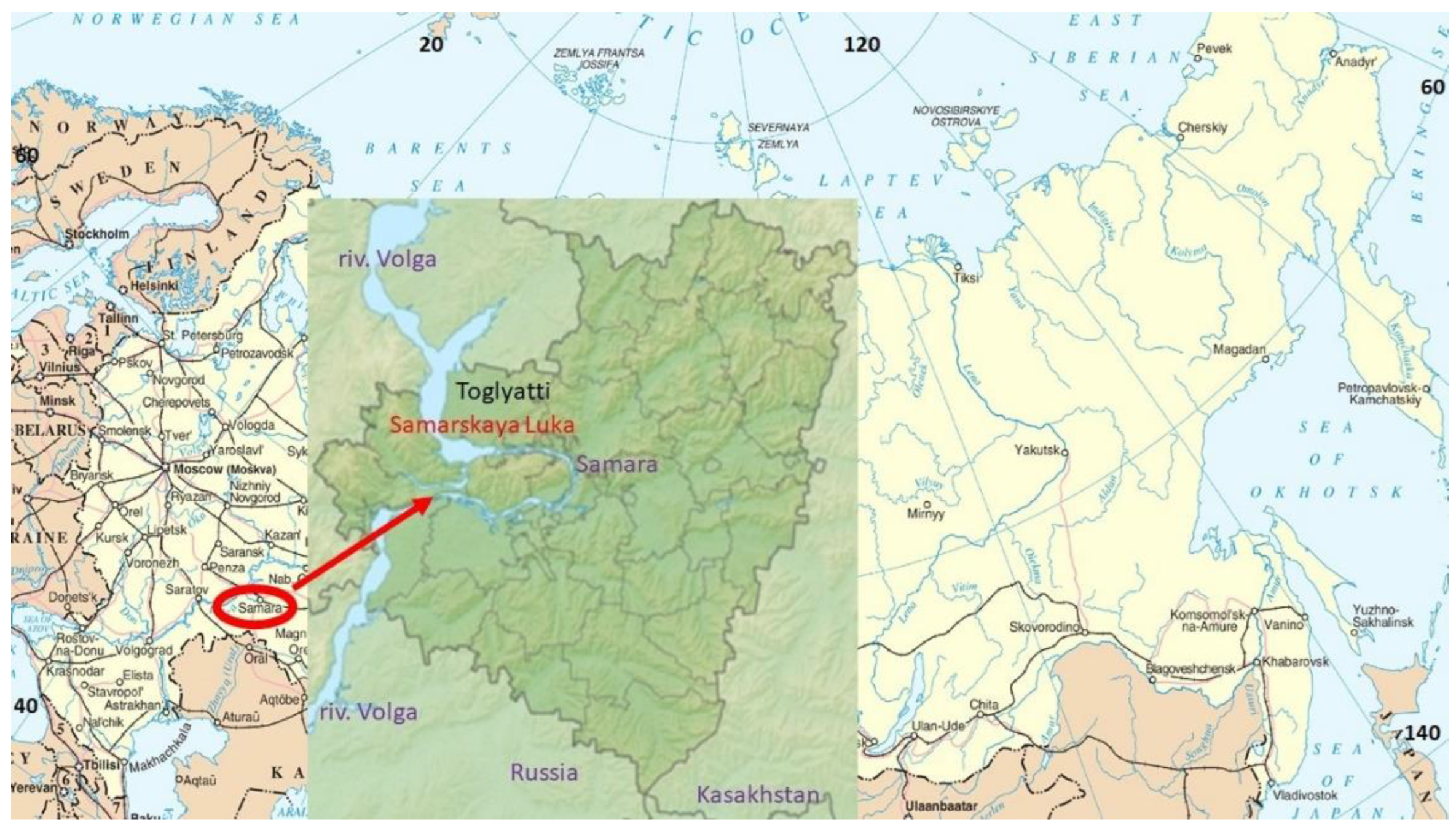
:1. Introduction
- (1)
- To describe the diversity of soil parent materials and to provide their chemical and mineralogical composition;
- (2)
- To analyze the role of geogenic factors in geographical soil pattern on Samarskaya Luka;
- (3)
- To evaluate the dependence of soil diversity from lithological inhomogeneity of territories.
2. Materials and Methods
2.1. Regional Settings
2.2. Climate and Biota
2.3. Geogenic Conditions and Landforms
2.4. Field Survey, Soil Diagnostics
2.5. Laboratory Methods
3. Results and Discussion
3.1. Characterization of Parent Materials
3.2. Soil Diversity
3.3. Soil Morphology
3.4. General Analytical Soil Characteristics
3.5. Soil Spatial Distribution
4. Conclusions
Funding
Institutional Review Board Statement
Informed Consent Statement
Data Availability Statement
Acknowledgments
Conflicts of Interest
Abbreviations
| WRB | world reference base of soil resources |
| O | forest floor |
| AU | dark humus horizon |
| AY | light humus horizon |
| AUe | dark humus horizon with eluviation of clay |
| AYe | light humus horizon with eluviation of clay |
| AEL | humus eluvial horizon |
| AB | transitional layer between A and B |
| AC | transitional layer between A and C |
| BEL | sub-eluvial horizon |
| Bw | weathering soil layer |
| Bm | cambic soil horizon |
| BI | clay illuvial horizon |
| BCA | horizon of secondary accumulation of carbonates |
| BCca | transitional horizon with primary carbonates |
| TOC | total organic carbon |
| TON | total organic nitrogen |
| C/N | carbon to nitrogen ration |
| C | parent material |
| G | gley horizon |
| Cg | gleyic horizon |
References
- Dokuchaev, V.V. Russian Chernozem; Russkaya Kollektsiya: Saint Petersburg, Russia, 2008; 480p. [Google Scholar]
- Vasilyevskaya, V.D.; Ivanov, V.V.; Bogatyrev, L.G. Soils of the North Part of Western Siberia; MSU: Moscow, Russia, 1986; 226p. [Google Scholar]
- Gagarina, E.U. Lithological Factor of Soil Formation (on Example of North-West Part of Russian Plain); SPBU: Saint-Petersburg, Russia, 2004; 257p. [Google Scholar]
- Nosin, V.A.; Agafodorov, I.P.; Krylov, V.P.; Sitnikova, B.L. Soils of Kuibyshev Oblast, 1st ed.; Prasolov, L.I., Ed.; OGIZ: Kuibyshev, Russia, 1949; 382p. [Google Scholar]
- Dobrovolsky, G.V.; Urusevskaya, I.S. Soil Geography; MSU: Moscow, Russia, 2004; 460p. [Google Scholar]
- Polynov, B.B. The First Stages of Pedogenesis on Massive Crystalline Rocks. Pochvovedenie 1945, 7, 327–339. [Google Scholar]
- Philippe, D. Precis de Pedologie; Paris Masson: Paris, France, 1961; p. 438. [Google Scholar]
- Kolomytz, E.G. Boreal Ecotone and Geographical Zonality; Nauka: Moscow, Russia, 2005; 390p. [Google Scholar]
- Urusevskaya, I.S.; Khokhlova, O.S.; Sokolova, T.A. An influence of parent materials on differentiations of soil cover in north part of Privolzhskaya upland. Eurasian Soil Sci. 1992, 8, 27–37. [Google Scholar]
- Abakumov, E.V.; Saksonov, S.V.; Saveliev, K.N. Soil-botanical excursions on North-East and East of Samara region: Perspective of regional Red soil data book creation. Trans. Samar Sci. Cent. RAS 2009, 11, 552. [Google Scholar]
- Chizhikov, P.N. The Map of Parent Materials of the European Part of the Soviet Union; MSU: Mocsow, Russia, 1968; 1p. [Google Scholar]
- Abakumov, E.V.; Gagarina, E.I. Soils of Samarskya Luka: Diversity, Genesis, Protection; Saint-Petersburg-State University: Saint Petersburg, Russia, 2008; 153p. [Google Scholar]
- Nature of the Kuibyshev Region; Oblastnoye Isdatelstvo- OGIZ: Kuibyshev, Russia, 1951; 382p.
- Ivanov, I.V. The soils of the Povolzhye. In Proceedings of the X International Congress of Soil Scientists, Kuibyshev, Russia; USSR Academy of Sciences, Institute of Agrochemistry and Soil Science: Puschino, Russia, 1974. [Google Scholar]
- Nosin, V.A. The Soils of Zhigulevsky State Reserve Named after I.I. Sprygin; Volgogiprozem: Kuibyshev, Russia, 1983; 216p. [Google Scholar]
- Chap, T.F.; Kholina, M.G.; Sokolova, Y.K. Structure of Soil Cover of Zhigulevsky Reserve. In Dinamika, Struktura Pochv i Sovremennyye Pochvennyye Protsessy: sb. Nauch. tr. TSNIL Glavookhoty RSFSR; Kuybishev: Samara, Iraq, 1987; pp. 51–65. [Google Scholar]
- Dyakonov, Y.S. Semi-Quantitative X-ray Determination of Clay Minerals (Layered Silicates); VIMSP: Moscow, Russia, 1984; 24p. [Google Scholar]
- Khitrov, N.B.; Rogovneva, L.V. Vertisols and vertic soils of the middle and lower Volga regions. Eurasian Soil Sci. 2014, 47, 1167–1186. [Google Scholar] [CrossRef]
- IUSS Working Group WRB. World Reference Base for Soil Resources 2014, Update 2015 International Soil Classification System for Naming Soils and Creating Legends for Soil Maps; World Soil Resources Reports No. 106; FAO: Rome, Italy, 2015. [Google Scholar]
- Shishov, L.L.; Tonkonogov, V.D.; Lebedeva, I.I.; Gerasimova, V.I. Classification and Diagnostic System of Russian Soils; Oikumena: Smolensk, Russia, 2004; 342p. [Google Scholar]
- Abakumov, E.; Fujitake, N.; Kosaki, T. Humus and humic acids of Luvisol and Cambisols of Jiguli ridges, Samara region, Russia. Appl. Environ. Soil Sci. 2009, 2009, 671359. [Google Scholar] [CrossRef] [Green Version]
- Chendev, Y.G.; Khokhlova, O.S.; Alexandrovskiy, A.L. Agrogenic evolution of automorphic chernozems in the forest-steppe zone (Belgorod oblast). Eurasian Soil Sci. 2017, 50, 499–514. [Google Scholar] [CrossRef] [Green Version]
- Goryachkin, S.V.; Spiridonova, I.A.; Targulian, V.O.; Sedov, S.N. Boreal soils of hard gypsum rocks: Morphology, properties and genesis. Eurasian Soil Sci. 2007, 36, 691–703. [Google Scholar]
- Gray, J.M.; Bishop, T.F.A.; Wilford, J.R. Lithology and soil relationship for soil modelling and mapping. Catena 2016, 147, 429–440. [Google Scholar] [CrossRef]
- Cámara, J.; Gómez-Miguel, V.; Martín, M.A. Lithologic control on soil texture heterogeneity. Geoderma 2017, 287, 157–163. [Google Scholar] [CrossRef]
- Kowalska, J.B.; Zaleski, T.; Józefowska, A.; Mazurek, R. Soil formation on calcium carbonate-rich parent material in the outer Carpathian Mountains—A case study. Catena 2019, 174, 436–451. [Google Scholar] [CrossRef]
- Kostenko, I.; Abakumov, E. Characterization of humic acids in mountain medow soils and burozems of the Crimea usind 13-C NMR. Eurasian Soil Sci. 2018, 51, 1411–1418. [Google Scholar] [CrossRef]
- Targulian, V.O. Micromorphology and Chemistry of Surface and Intrasoil Weathering in Cold Humid Regions of Tundra and Northern Taiga. In Micromorphological Method in the Study of Soil Genesis; Nauka: Moscow, Russia, 1966; pp. 129–164. [Google Scholar]


| Type of Relief | Type of Quaternary Parent Materials |
|---|---|
| Zhiguli Mountains the tops and upper parts of the slopes | Eluvium of limestones and dolomites of the Carboniferous and Permian |
| Zhiguli Mountains the tops and upper parts of the slopes of the Eastern part of Samarskaya Luka | Eluvium of gypsum |
| Middle and lower Slopes of Zhiguli ridges, intermountain valleys | Colluvium in the mountainous part |
| Central denudation plateau of Samarskaya Luka | Eluvium of Jurassic clays, loams, sands; |
| Southern denudation plateau of Samarskaya Luka | Eluvium of the Akchagyl transgressive sand and clay series; |
| Eastern-southern denudation plateau of Samarskaya Luka | Eluvium of Neogene greenish transgressive clays |
| South-western part of plateau of Samarskaya Luka | Loess-like loams |
| Denudation valleys of late Pleistocene | Loess type slope deluvium |
| Mountainous, plateau, slope | Deluvium of various sediments and of mixed composition |
| Type of Parent Material | Type of Dominated Soil | Content of Carbonates, % | pH in Water of Parent Material | Content of Clay, % | Mineralogical Content of Clay Fraction |
|---|---|---|---|---|---|
| Eluvium of limestones | Leptosols Calcaric | 30–80 | 7.6 | 25–30 | Smectite-kaolinite-illite |
| Deluvium of bedrock mountain slopes | Cambisols | 12–15 | 7.3 | 65–70 | Smectite-illite- kaolinite |
| Deluvium bedrock Plateau | Retisols, Umbric Retisols | 5–9 | 7.0–7.5 | 50 | |
| Jurassic clay eluviums | Retisols Albic | 0 | 5.0 | 30–60 | Illite-kaolinite at very small smectite admixture |
| Loess-like deluvium of denudation valleys | Phaeozems Luvic | 10–12 | 7.0–8.3 | 40–50 | Smectite-illite- kaolinite |
| Proluviums of denudation valleys | Phaeozems Luvic | 0–4 | 6.0–7.2 | 35–50 | Smectite-kaolinite-illite |
| The Akchagyl clays | Phaeozems Petrocalcic Calcaric | 18–27 | 8.0–8.5 | 45–55 | Smectite-illite- kaolinite |
| Soil Type/Horizon | TOC, % | TON, % | C/N | CaCO3 | pH | Sand, % | Silt, % | Clay, % | Skeleton, % | Fine Earth, % |
|---|---|---|---|---|---|---|---|---|---|---|
| Leptosol | ||||||||||
| O | 39.68 | 1.20 | 32.24 | nd | 6.6 | nd | nd | nd | nd | td |
| AU | 5.70 | 0.59 | 9.66 | 14.5 | 7.2 | 85 | 10 | 5 | 45 | 55 |
| AC | 2.47 | 0.51 | 4.84 | 22.0 | 7.8 | 89 | 10 | 1 | 57 | 43 |
| C | 0.21 | 0.03 | 7.00 | 51.2 | 8.2 | 95 | 4 | 1 | 75 | 25 |
| Cambisol Hyperskeletic | ||||||||||
| O | 45.00 | 1.89 | 23.81 | nd | 6,7 | nd | nd | nd | nd | td |
| AU | 3.20 | 0.45 | 7.11 | 3.4 | 7.2 | 35 | 35 | 30 | 68 | 32 |
| BM | 1.23 | 0.12 | 10.25 | 4.5 | 7.7 | 15 | 40 | 45 | 65 | 35 |
| BC | 0.78 | 0.05 | 15.60 | 7.6 | 8.0. | 25 | 40 | 35 | 70 | 30 |
| Cca | 0.24 | 0.03 | 8.00 | 10.2 | 8.2 | 35 | 30 | 35 | 76 | 24 |
| Cambisol | ||||||||||
| O | 39.00 | 3.88 | 10.05 | nd | 7.2 | nd | nd | nd | nd | td |
| AU | 3.90 | 0.28 | 13.92 | 0.5 | 6.8 | 20 | 40 | 40 | 10 | 90 |
| BM | 0.40 | 0.07 | 5.71 | 1.2 | 5.7 | 15 | 40 | 45 | 12 | 88 |
| BC | 0.23 | 0.05 | 4.60 | 1.7 | 6.2 | 25 | 45 | 30 | 15 | 75 |
| C | 0.15 | 0.02 | 7.59 | 4,0 | 6.8 | 30 | 35 | 35 | 18 | 82 |
| Retisol on Jurassic clays | ||||||||||
| O | 46.50 | 1.55 | 30.00 | nd | 6.7 | nd | nd | nd | nd | nd |
| AY | 3.50 | 0.41 | 8.53 | 0.0 | 6.3 | 43 | 35 | 22 | 5 | 95 |
| AEL | 1.91 | 0.21 | 9.05 | 0.0 | 5.5 | 26 | 42 | 33 | 5 | 95 |
| BEL | 0.61 | 0.05 | 12.20 | 0.0 | 5.4 | 24 | 30 | 46 | 5 | 95 |
| BC | 0.50 | 0.05 | 10.00 | 0.0 | 5.2 | 35 | 16 | 49 | 5 | 97 |
| C | 0.20 | 0.03 | 6.67 | 0.0 | 5.1 | 47 | 13 | 40 | 3 | 97 |
| Retisol | ||||||||||
| O | 55.70 | 2.40 | 23.20 | nd | 6.8 | 28 | 35 | 37 | nf | nd |
| AYe | 4.50 | 0.55 | 8.18 | 0.0 | 6.7 | 24 | 30 | 46 | 8 | 92 |
| BEL | 2.90 | 0.34 | 8.53 | 0.0 | 6.7 | 27 | 30 | 43 | 10 | 90 |
| BC | 1.90 | 0.22 | 8.63 | 0.5 | 6.9 | 27 | 31 | 42 | 10 | 90 |
| C | 0.50 | 0.06 | 8.33 | 1.2 | 7.2 | 17 | 28 | 55 | 15 | 85 |
| Chernozem Luvic | ||||||||||
| AU | 5.60 | 0.45 | 12.44 | 0.0 | 6.0 | 22 | 32 | 46 | 12 | 88 |
| AUe | 3.14 | 0.38 | 8.26 | 0.0 | 6.0 | 21 | 30 | 49 | 10 | 90 |
| BI | 2.32 | 0.35 | 6.62 | 0.0 | 5.9 | 17 | 35 | 48 | 8 | 92 |
| BC | 1.70 | 0.25 | 6.80 | 0.5 | 6.0 | 32 | 18 | 50 | 8 | 92 |
| C | 0.50 | 0.07 | 7.14 | 1.5 | 6.3 | 33 | 16 | 51 | 10 | 90 |
| Chernozem Calcaric | ||||||||||
| AU | 7.89 | 0.98 | 8.05 | 1.5 | 7.2 | 23 | 29 | 48 | 15 | 85 |
| AB | 6.78 | 0.66 | 10.27 | 2.6 | 7.4 | 23 | 26 | 51 | 15 | 85 |
| BCA | 3.45 | 0.45 | 7.66 | 2.9 | 8.0 | 25 | 22 | 53 | 18 | 82 |
| BCca | 2.13 | 0.23 | 9.26 | 7.5 | 8.5 | 21 | 29 | 50 | 19 | 81 |
| Cca | 0.54 | 0.07 | 7.71 | 8.0 | 8.5 | 22 | 29 | 49 | 20 | 80 |
| Fluvisols close to river bed | ||||||||||
| AY | 2.34 | 0.23 | 10.18 | 0.0 | 5.9 | 31 | 44 | 25 | 10 | 90 |
| C | 1.21 | 0.17 | 7.11 | 0.0 | 6.0 | 45 | 37 | 18 | 19 | 81 |
| AY | 2.45 | 0.25 | 9.80 | 0.0 | 6.2 | 29 | 45 | 26 | 8 | 92 |
| C | 0.56 | 0.09 | 6.22 | 0.0 | 6.0 | 49 | 32 | 19 | 26 | 74 |
| AY | 3.45 | 0.31 | 11.13 | 0.0 | 5.8 | 23 | 47 | 30 | 11 | 89 |
| C | 0.23 | 0.03 | 7.66 | 0.0 | 5.9 | 52 | 31 | 17 | 32 | 68 |
| Fluvisol of oxbow flood plains | ||||||||||
| AU | 5.67 | 0.34 | 16.67 | 0.0 | 6.8 | 20 | 45 | 35 | 5 | 95 |
| Cg | 1.00 | 0.08 | 12.50 | 0.0 | 6.9 | 19 | 43 | 38 | 3 | 97 |
| G | 0.43 | 0.05 | 8.60 | 0.0 | 7.0 | 18 | 44 | 38 | 10 | 90 |
Publisher’s Note: MDPI stays neutral with regard to jurisdictional claims in published maps and institutional affiliations. |
© 2022 by the author. Licensee MDPI, Basel, Switzerland. This article is an open access article distributed under the terms and conditions of the Creative Commons Attribution (CC BY) license (https://creativecommons.org/licenses/by/4.0/).
Share and Cite
Abakumov, E. Pedodiversity of Subboreal Ecosystems under Contrasting Geogenic Factors (Case Study of Samarskaya Luka, Middle Volga Region, Russia). Geosciences 2022, 12, 443. https://doi.org/10.3390/geosciences12120443
Abakumov E. Pedodiversity of Subboreal Ecosystems under Contrasting Geogenic Factors (Case Study of Samarskaya Luka, Middle Volga Region, Russia). Geosciences. 2022; 12(12):443. https://doi.org/10.3390/geosciences12120443
Chicago/Turabian StyleAbakumov, Evgeny. 2022. "Pedodiversity of Subboreal Ecosystems under Contrasting Geogenic Factors (Case Study of Samarskaya Luka, Middle Volga Region, Russia)" Geosciences 12, no. 12: 443. https://doi.org/10.3390/geosciences12120443
APA StyleAbakumov, E. (2022). Pedodiversity of Subboreal Ecosystems under Contrasting Geogenic Factors (Case Study of Samarskaya Luka, Middle Volga Region, Russia). Geosciences, 12(12), 443. https://doi.org/10.3390/geosciences12120443