Article

The Role of Rheology and Fault Geometry on Fault Reactivation: A Case-Study from the Zsámbék-Mány Basin, Central Hungary

1
Supervisory Authority of Regulatory Affairs, 17-23 Columbus u., 1145 Budapest, Hungary
2
Department of Geology, Institute of Geography and Earth Sciences, ELTE 1/C Pázmány sétány, 1117 Budapest, Hungary
3
ELKH Institute of Earth Physics and Space Science, 6-8 Csatkai E. Str, 9400 Sopron, Hungary
4
Department of Geology and Meteorology, University of Pécs, 6 Ifjúság útja, 7624 Pécs, Hungary
5
UMR SU CNRS EPHE 7619 METIS, Sorbonne Université, 75005 Paris, France
*
Author to whom correspondence should be addressed.
Geosciences 2022, 12(12), 433; https://doi.org/10.3390/geosciences12120433
Submission received: 9 September 2022 / Revised: 4 November 2022 / Accepted: 17 November 2022 / Published: 24 November 2022
(This article belongs to the Special Issue Inversion in Thrust Belts and Their Forelands)

Abstract

:
In this study, we investigated the structural evolution of the Vértessomló (VT) Thrust and the Környe-Zsámbék (KZ) Fault, which are located in the Transdanubian Range in the center of the Miocene Pannonian back-arc basin. Our study is based on surface and well data. The Transdanubian Range was located on the Adriatic passive margin during the Late Triassic, where a thick succession of platform carbonates was deposited. Intercalations of intraplatform basin deposits occur in the eastern part of the study area. South-directed thrusting and the formation of the VT Thrust took place during the Cretaceous, related to the Austroalpine orogeny. Asymmetric half-grabens were formed during the Eocene in the hanging wall of the segmented dextral normal KZ Fault. The geometry and kinematics of the KZ Fault were influenced by the pre-existing VT Thrust located in the Mesozoic basement of the Paleogene sub-basins. These Eocene half-grabens suffered mild inversion due to the dextral reverse reactivation of the VT Thrust and the KZ Fault during the Oligocene–Early Miocene. The geometry of Miocene normal faults indicates that the VT-KZ Fault system was an active transfer fault during the Miocene extension of the Pannonian Basin, as well. We found a positive correlation between the rheology of the Triassic basement and the mode of Paleogene fault reactivation. Our results show that reactivation of the pre-existing thrust took place along that segment, where the Triassic basement is made up of homogeneous platform carbonates. In contrast, a diffuse fault zone developed, where the Triassic basement is represented by the weak layers of intraplatform basins.

1. Introduction

Fault reactivation is a frequent and extensively studied phenomenon, both along plate boundaries and in plate interiors, where different types of fault reactivation take place during the distinct stages of an orogenic cycle. Continental rift zones are frequently located in former orogens [1], where extensional reactivation or negative inversion of former thrusts occur [2,3]. Even the onset of intra-oceanic subduction might be localized by pre-existing detachment faults [4]. Subduction of former rifted margins resulted in the positive inversion of former extensional grabens and half-grabens and reverse reactivation of pre-existing normal faults. Extensive literature is available for positive inversion, which has been described in several orogens worldwide [5,6,7,8,9,10,11,12,13]. Lateral extrusion and/or extensional collapse [14,15] take place frequently at the final stage of collision. In some cases, the extrusion-related strike-slip faults reactivate pre-existing thrusts [16,17,18,19], particularly those that are steeply tilted at the backstop of the orogenic wedge. In this study, we describe the complex deformation history of the Vértessomló Thrust (VT) and Környe-Zsámbék (KZ) fault system running across the Zsámbék–Mány Basin, which is a young sub-basin of the Pannonian back-arc basin (Figure 1). We carried out a study of well and surface data, which permit the reconstruction of repeated reactivations of the VT-KZ Fault system during the different stages of the Alpine orogenic cycle, from the Triassic passive margin evolution through the Cretaceous nappe emplacement and Paleogene extrusion tectonics. We demonstrate how the original Triassic facies determined the original thrust system and its reactivation through the deformation history.

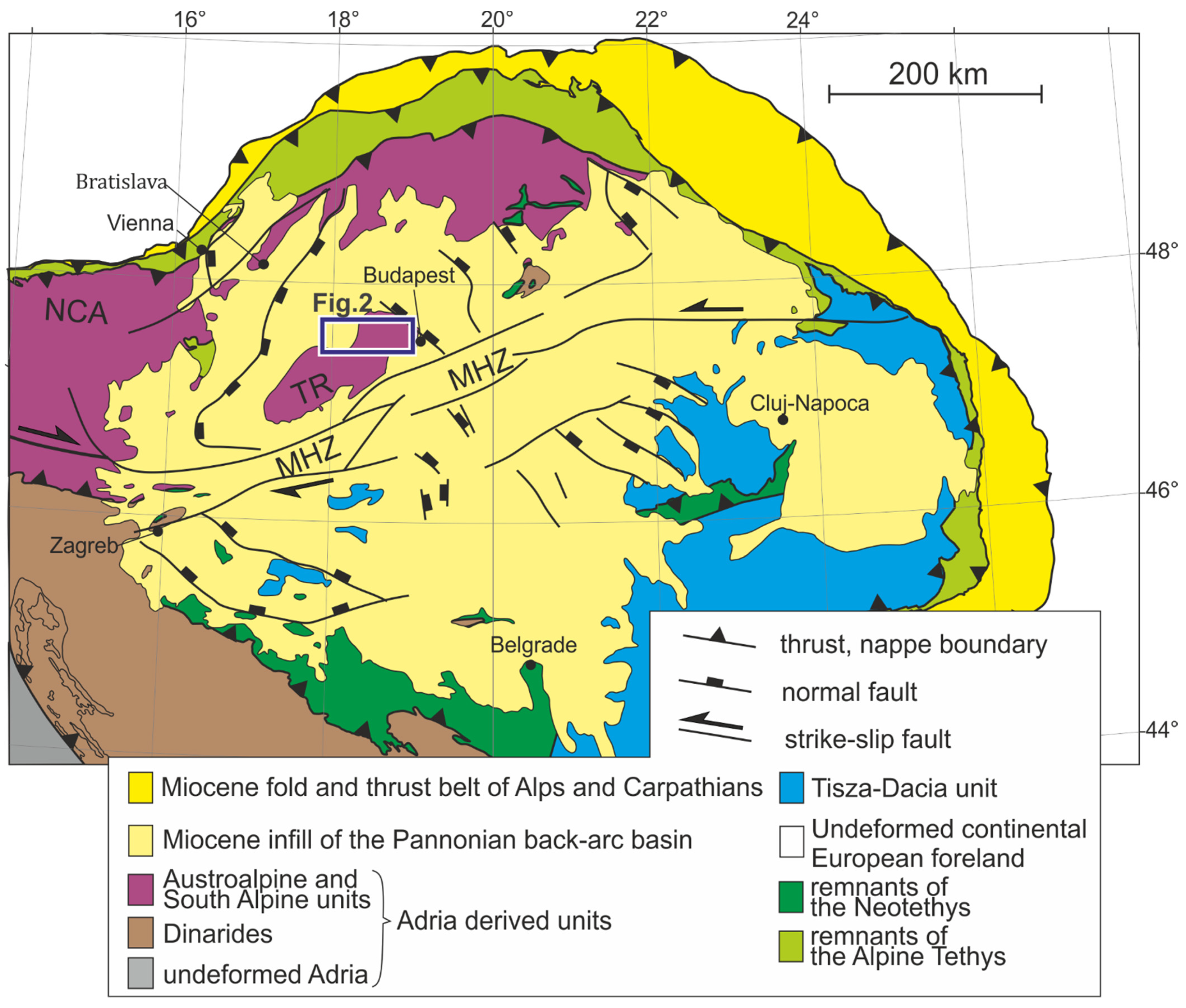
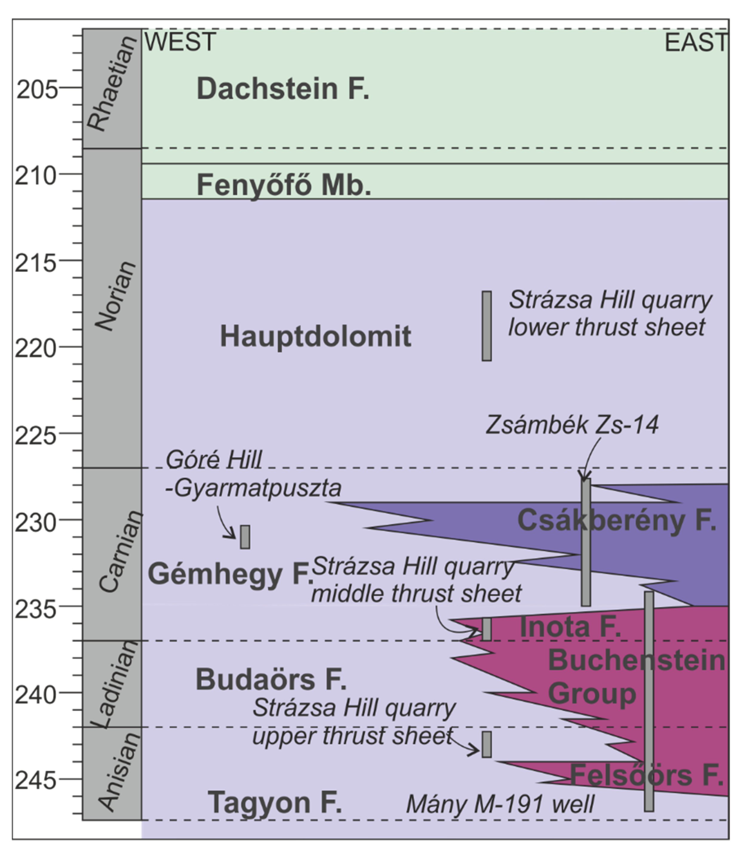
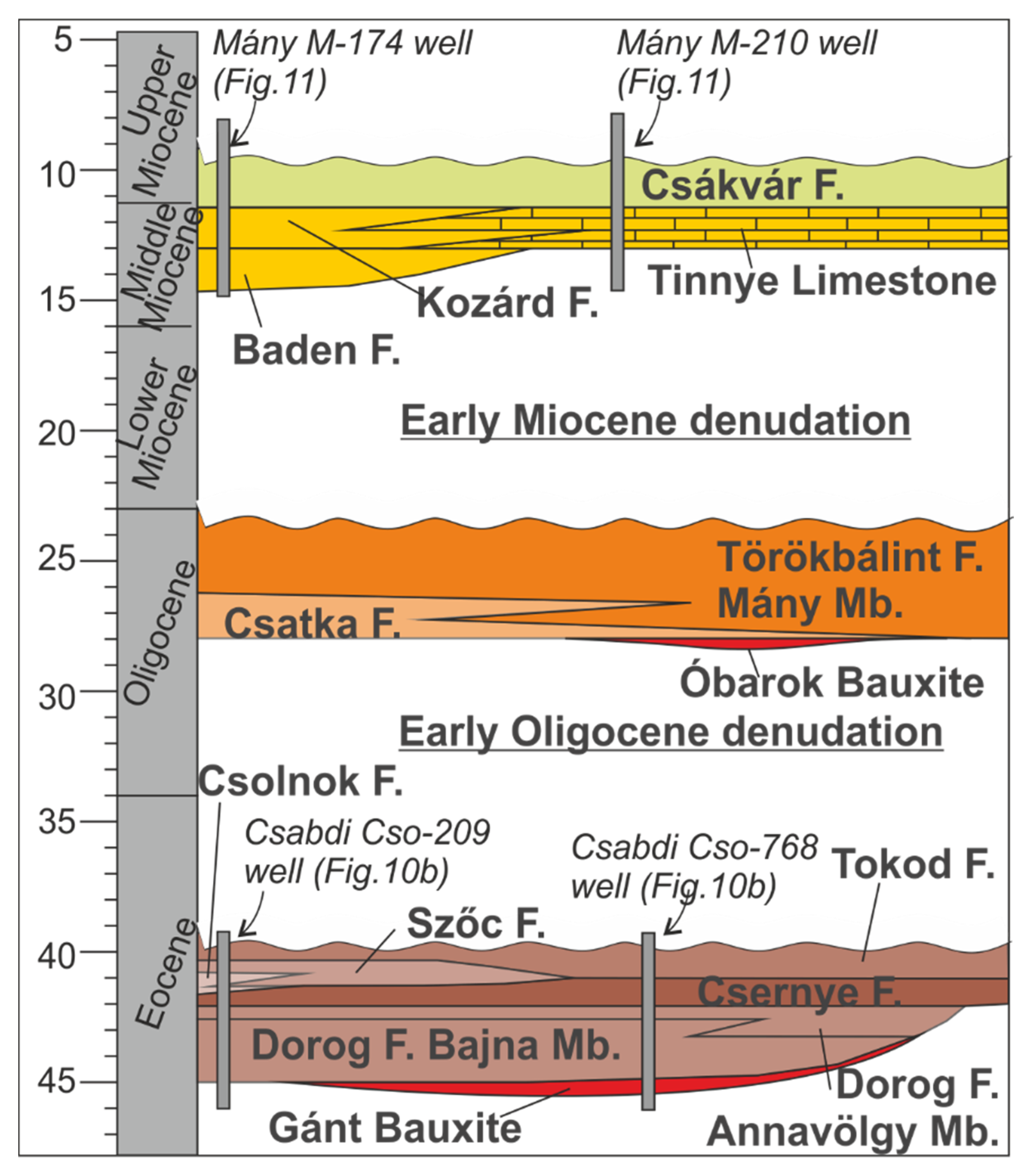
2. Geology of the Study Area

The Zsámbék–Mány Basin is situated in the northeastern part of the Transdanubian Range (TR), in the center of the Pannonian back-arc basin (Figure 1 and Figure 2). The Transdanubian Range is the uppermost nappe of the Austroalpine nappe-system [22], which represents a part of the Adriatic plate [23] (Figure 1). The post-Variscan evolution of the Adriatic plate was controlled by the opening and the closure of two distinct oceanic domains, the Neotethys and the Alpine Tethys [23]. The TR is built up by Variscan low-grade metasedimentary rocks and a Permian to Cenozoic non-metamorphic sedimentary succession.
The Permian to early Middle Triassic sediments of the TR deposited in rift basins, which preceded the opening of the Neotethys Ocean. Continental sandstone, evaporate, and dolomite was deposited during the Late Permian in the NE part of the TR [29]. These deposits are covered by Early to early Middle Triassic mixed siliciclastic-carbonate succession, which formed on a shallow marine ramp [30].
The Anisian onset of the oceanic spreading of the Neotethys led to the partial drowning of the shallow marine carbonate ramp (Tagyon Formation, Figure 3): cherty limestones (Felsőörs F.) together with tuffs (Buchenstein Group) deposited in the tectonically controlled grabens and half-grabens [31,32], whereas the production of shallow marine carbonate continued on the elevated platform areas (Tagyon Fm., Budaörs Fm.) (Figure 3). These Middle Triassic basinal deposits were drilled by several wells in the Zsámbék–Mány Basin (Mány M-191, M-245, M-246; for location, see Figure 4) [33]. Similar tuffs, clays and coarse-grained volcanoclastic sediments (Inota Fm.) are exposed in the Strázsa Hill quarry at Zsámbék [34] (for location, see Figure 4). U-Pb geochronological data measured on zircons of the Inota Fm indicate that the volcanism was active until the Early Carnian in the northeastern part of the TR [35]. The late Anisian–Ladinian Budaörs Fm is made up of thick-bedded dolomite with cyclic stromatolite intercalations. The most important index fossil of this formation is the Diplopora annulata, which was found in the Strázsa Hill quarry [34] (for location, see Figure 4). The production of shallow marine dolomite continued during the Carnian (Gémhegy Formation) [36]. This formation crops out in the Góré Hill (near Gyarmatpuszta), where Carnian Megalodontids [37] and dasycladalea remains [34] were described (for location, see Figure 4). The Late Carnian basinal succession is represented by cherty dolomites and limestones of the Csákberény Fm. [36], which was documented in detail by Haas et al. [38] based on the Zsámbék Zs-14 well (for location, see Figure 4).
From the end of the Carnian, a broad carbonate platform developed, where the Hauptdolomit deposited during the Norian and the Dachstein Limestone in the Raethian (Figure 3). Both formations are characterized by a cyclic succession of thick-bedded shallow marine carbonates and stromatolites [30]. The boundary of the two formations is a transitional unit in which intertidal dolomites and subtidal limestones alternate (Fenyőfő Mb.) (Figure 3). The upper sections of the Mesozoic succession were eroded in the study area. In the following, we briefly summarize the Jurassic–Early Cretaceous succession of the northeastern TR, which provides important insights into the structural evolution of the study area.
The drowning of the Dachstein platform occurred at the Triassic-Jurassic boundary. The Jurassic succession is built up by condensed pelagic sediments, like ammonitico rosso type limestones, marlstones and radiolarite [39].
Intra-oceanic subduction was initiated in the Neotethys during the Middle Jurassic [23]. The Adriatic continental lithosphere entered into this subduction zone after the consumption of the lower oceanic lithosphere of the Neotethys. Shortening-related deformation progressively migrated on the Adriatic margin from Late Jurassic to the Early Cretaceous, which led to the formation of the Austroalpine nappe system. A foreland basin developed in the NE part of the TR (north of the study area) during the early stage of orogeny [22,40]. Early Cretaceous deep marine marl and upward coarsening turbiditic succession were deposited in this foreland basin, whereas Late Aptian shallow marine bioclastic limestone (Tata Fm) was deposited on the forebulge [41]. The TR suffered significant contractional deformation before, during or after the deposition of the Tata Limestone [41,42], which is manifested in variously oriented folds and thrusts in the NE part of the TR [43,44]. One of the most significant Cretaceous structures is the south-vergent Vértessomló (VT) Thrust [45,46,47,48,49], which crosses the study area in the E-W direction [34,50] (Figure 2 and Figure 4). Due to these folding phases, the Jurassic to Early Cretaceous sequences were eroded in the study area in the Late Cretaceous.
The subduction of the Alpine Tethys was going on during the Late Cretaceous and the Paleogene, where the Adriatic plate (including the TR) represented the upper plate [23]. Prior to and during the collision of Adria and Europe a retro-wedge foreland basin, the Hungarian Paleogene Basin, developed on the upper plate [51]. The deposits of the Hungarian Paleogene Basin unconformably cover the folded Mesozoic beds. The Gánt Bauxite is overlain by a clastic coal-bearing succession of the Dorog Fm., which was deposited in fluvial and lacustrine, later in a marine swamp environment [52] (Figure 5). Due to the late Lutetian transgression, a mixed siliciclastic-carbonate succession of the Csernye Fm. deposited in a lagoon and shallow sea, laterally interfingering with the shallow marine carbonate ramp facies of the Szőc Limestone [52] (Figure 5). It contains fossils indicating normal salinity: primarily large foraminiferas, locally red algae in rock-forming quantity, as well as molluscs, echinoids, decapods, corals and vertebrate remains. The Eocene carbonate sequence interfingers with basinal marls toward the pelagic basin. Deeper marine (outer ramp) homogenous, well-bedded, grey clay marl and marl succession of the Csolnok Fm. represents partly heterotopic facies of the Szőc Fm. Fine to coarse-grained siliciclastic and marly succession (deltaic system deposit) of the Tokod Formation represent the youngest member of the Eocene succession in the study area [52].
The rest of the Eocene succession was eroded due to the Early Oligocene uplift and subaerial erosion. The Oligocene succession begins with bauxite (Óbarok Fm.), which is overlain by the terrestrial (fluvial) succession of the Csatka Fm. which is laterally interfingering with the shallow marine siliciclastic succession of the Törökbálint Fm eastward [52] (Figure 5). The deposits of a wide transitional zone between the fluvial and marine environments are represented by the Mány Mb., which is a characteristic sediment of the study area [52].
The subducted lithosphere of the Alpine Tethys tore off below the Eastern Alps after the Adria-Europe collision, and the slab pull forces retreated towards the East, under the Carpathians [53]. The combination of these processes resulted in the crustal-scale eastward lateral extrusion of a part of the Austroalpine nappes during the Late Oligocene–Early Miocene and the formation of the Pannonian back-arc basin during the Miocene [54,55,56].
The Early Miocene uplift and subaerial exposure of the study area is related to the extrusion tectonics, whereas the onset of late Early Miocene sedimentation migrated in time from NW to SE and took place in syn-sedimentary grabens and half-grabens, associated with the opening of the Pannonian back-arc basin [22,57]. Deep water marls (Baden and Kozárd Fm.) deposited in the grabens and half-grabens during the Miocene, whereas shallow-water limestone of the Tinnye Fm. deposited on the tectonically controlled elevated areas [58,59,60]. The Upper Miocene is represented by the clays and silts of the Csákvár Fm., which was deposited in swamps [52].

3. Methods and Data

The study area was the focus of intense exploration for Paleogene bauxites and coal deposits. Due to the raw material research, data for more than 1700 wells are available (for the locations of the wells, see Figure 4). Geological maps [24,25,26,27,28] were also used for the structural analysis of the study area.
We constructed the pre-Quaternary (Figure 4) geological map of the study area after filtering the topmost pre-Quaternary picks in every well. We took into account the exposed outcrops of pre-Quaternary formations on the mentioned maps during map construction.
We constructed the grids of major unconformities, namely the base of the Eocene, the base of the Oligocene and the base of the Miocene, by using Delaunay triangulation. The thickness map of the Eocene (for location see Figure 4) is based on the vertical difference between the base of the Eocene and the base of the Oligocene grids. Well data show that the Eocene succession is almost exclusively covered by Oligocene in the study area. Therefore only the Early Oligocene erosion decreased the thickness of the Eocene succession, and the pre-Middle Miocene erosion did not affect the Eocene thickness values. Consequently, recent Eocene thickness data reflect the sum of the original thickness of the Eocene and the amount of Early Oligocene erosion. These assumptions are not valid for a small area north of Nagyegyháza village (western boundary of the study area, Figure 4), where Eocene sediments are situated near/on the surface, and they suffered Quaternary erosion, as well.
We constructed geological sections (for location of the sections see Figure 4) based on well and surface data. We took a 100 m maximum projection distance for the wells, except the section of Figure 6A, where the maximum projection distance was 730 m.

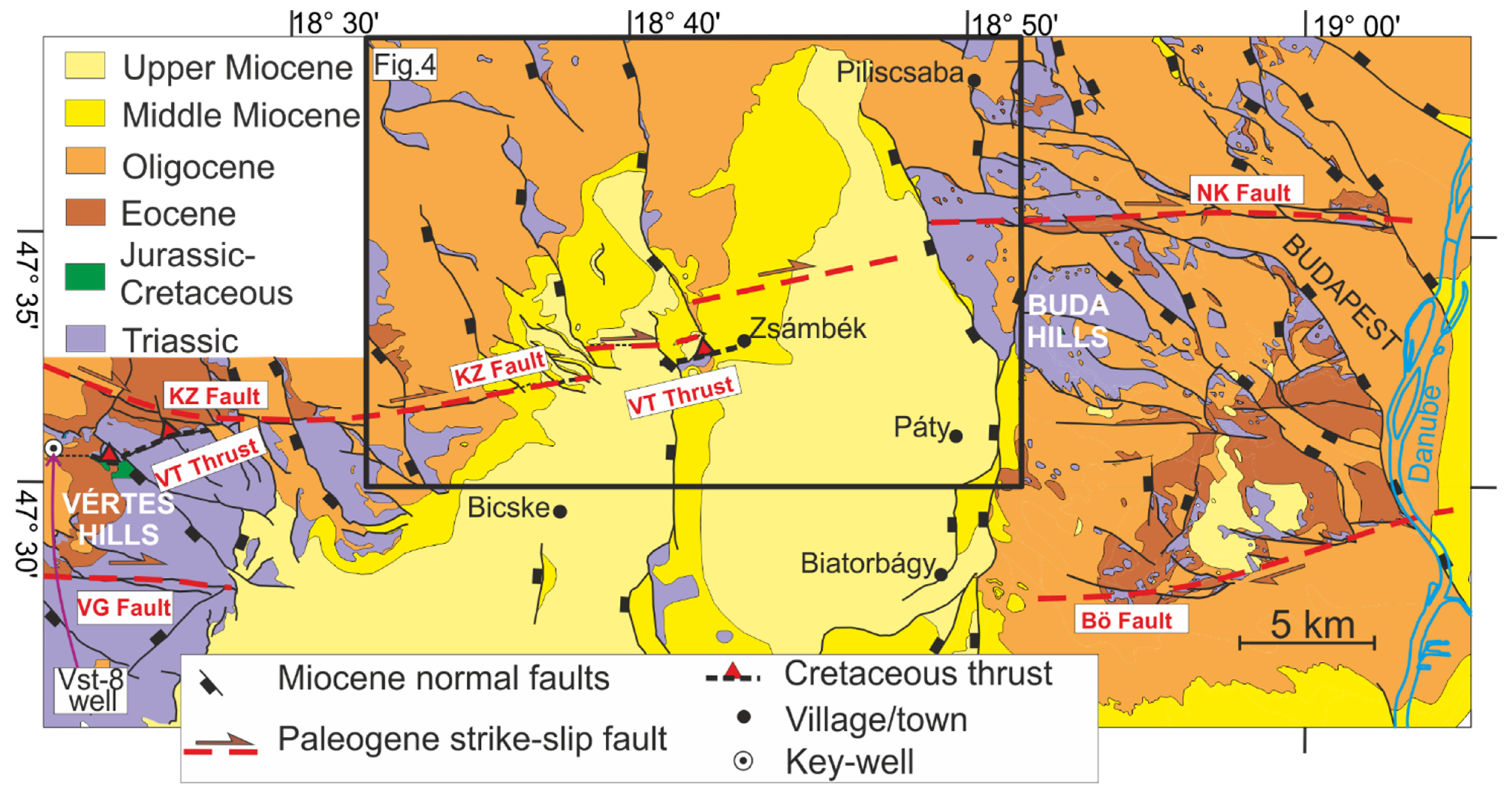
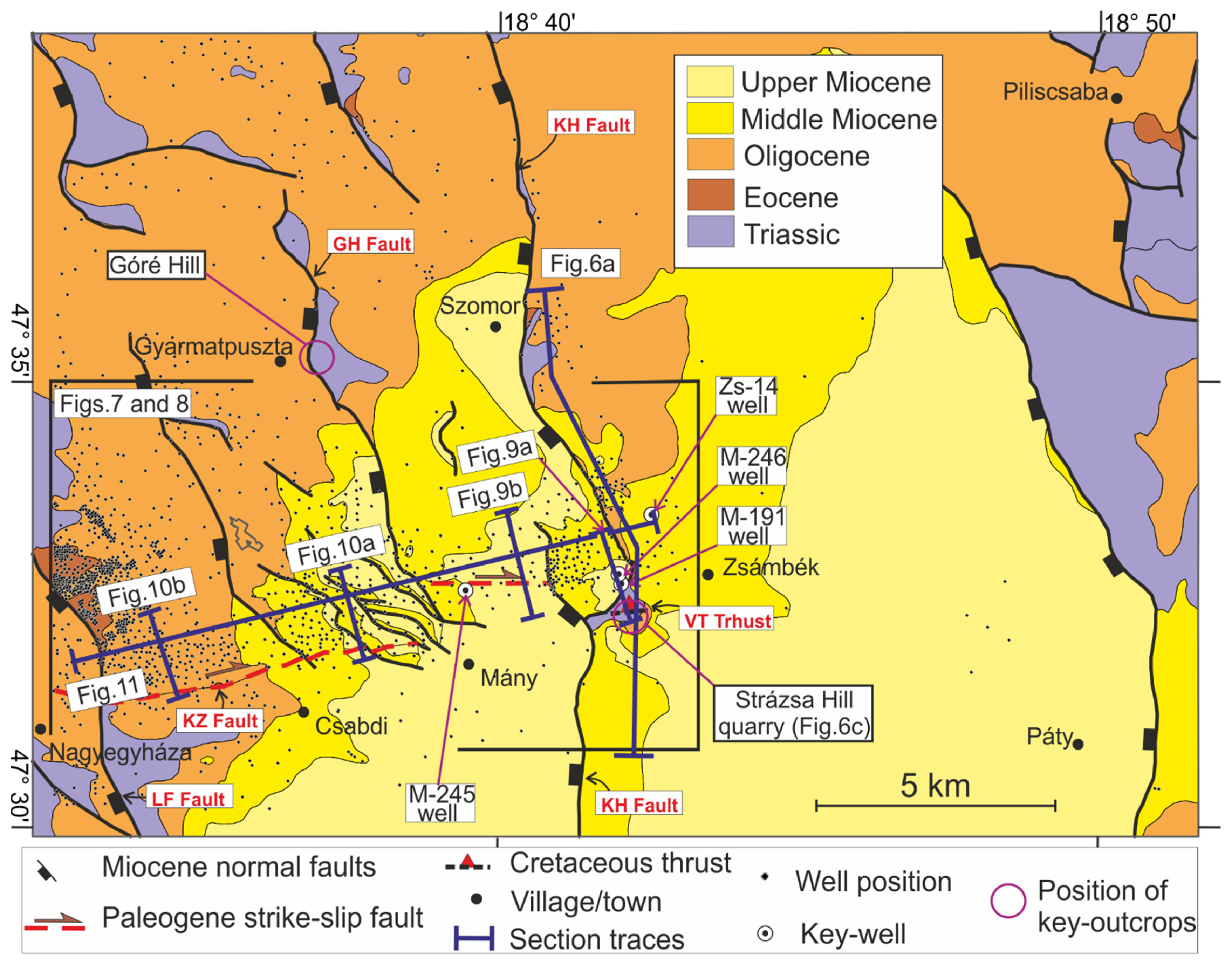
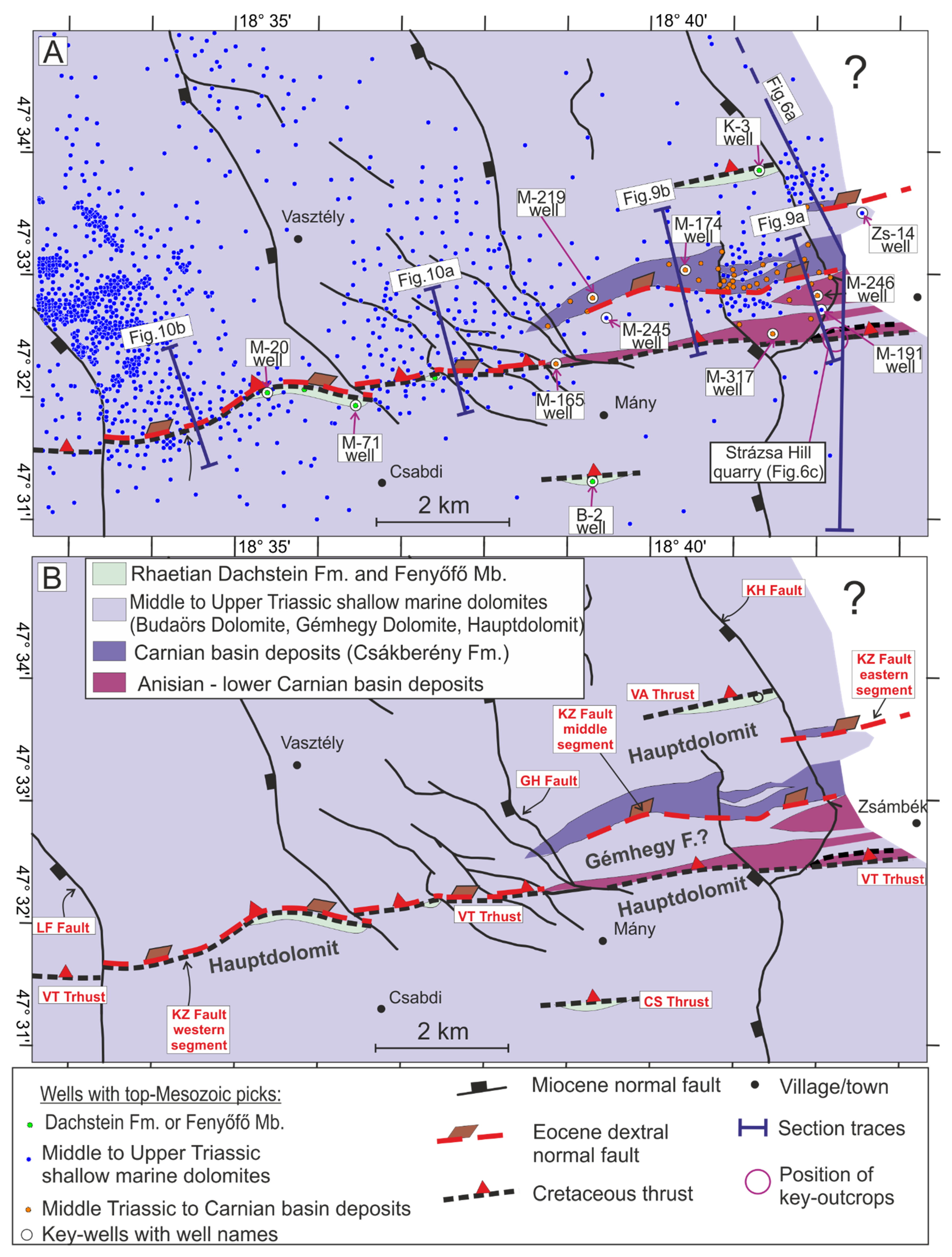
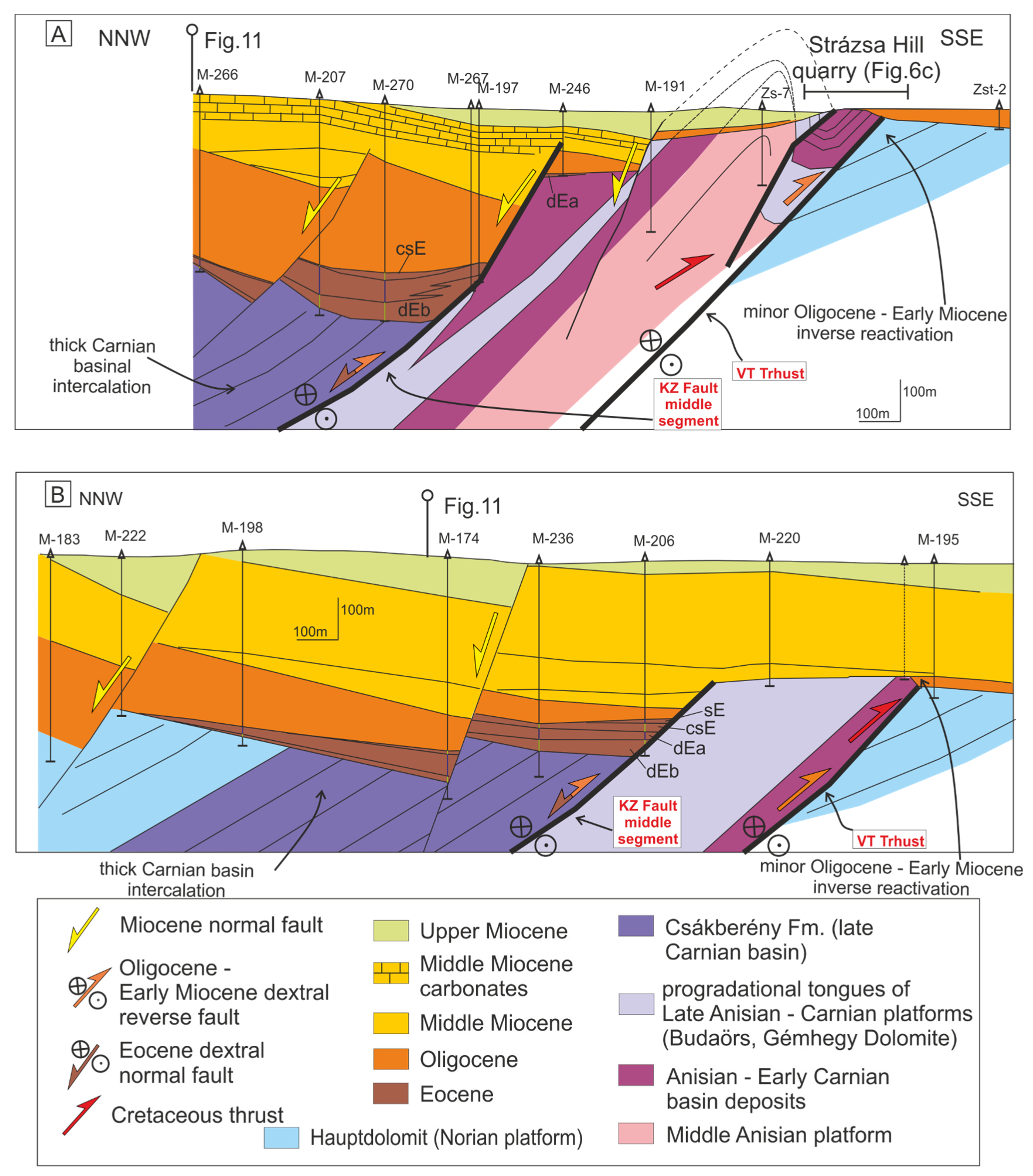
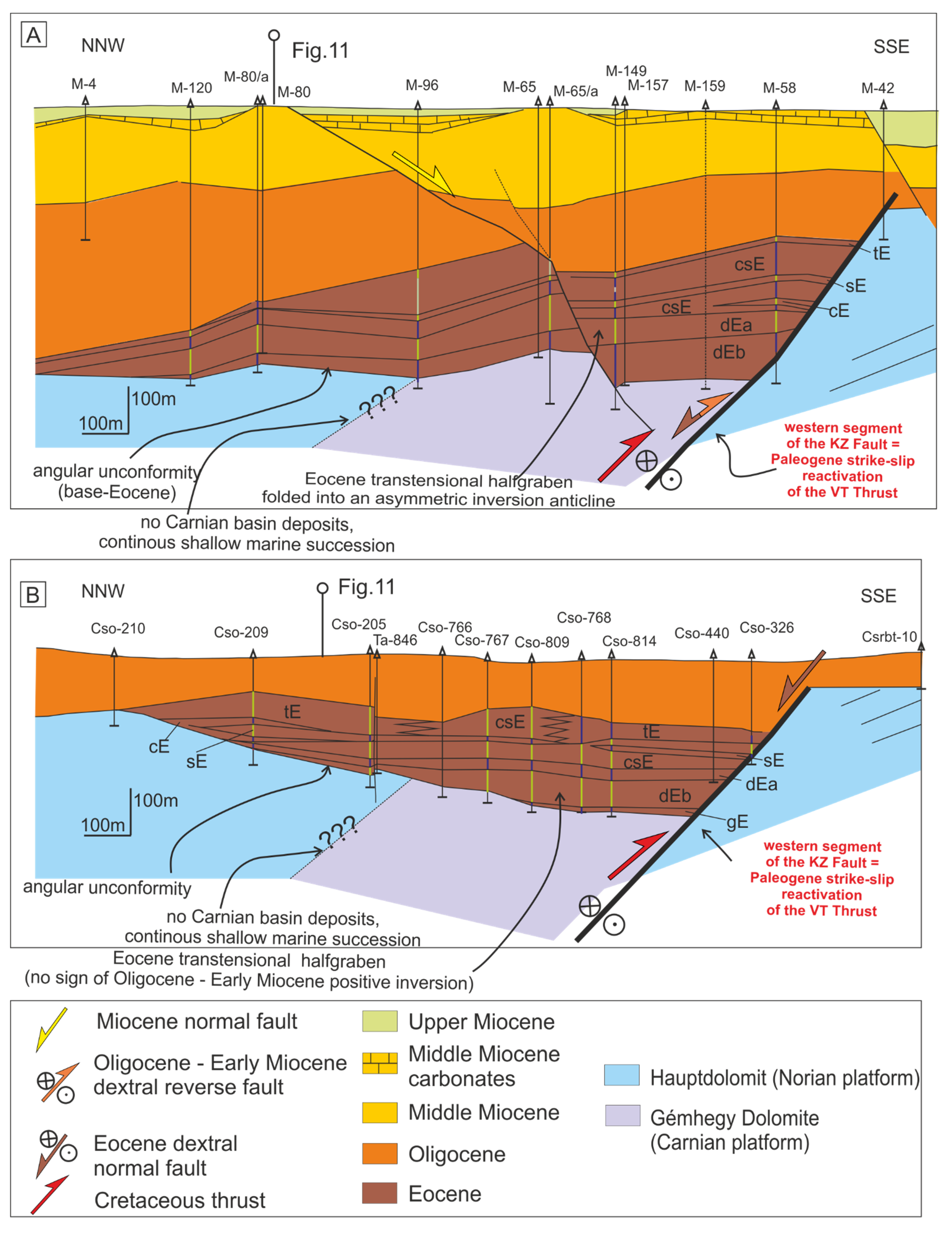
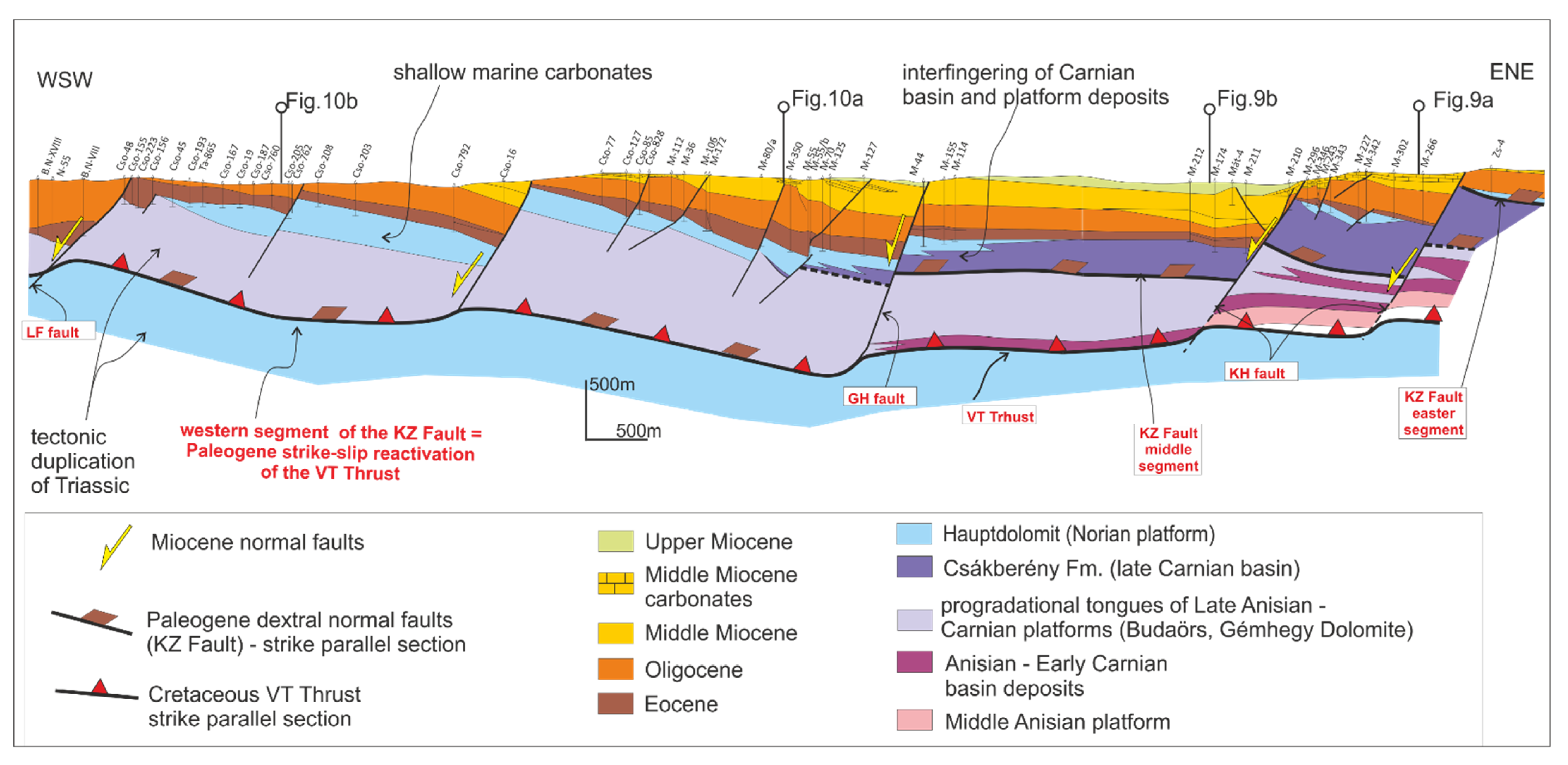
4. Structure of the Zsámbék–Mány Basin

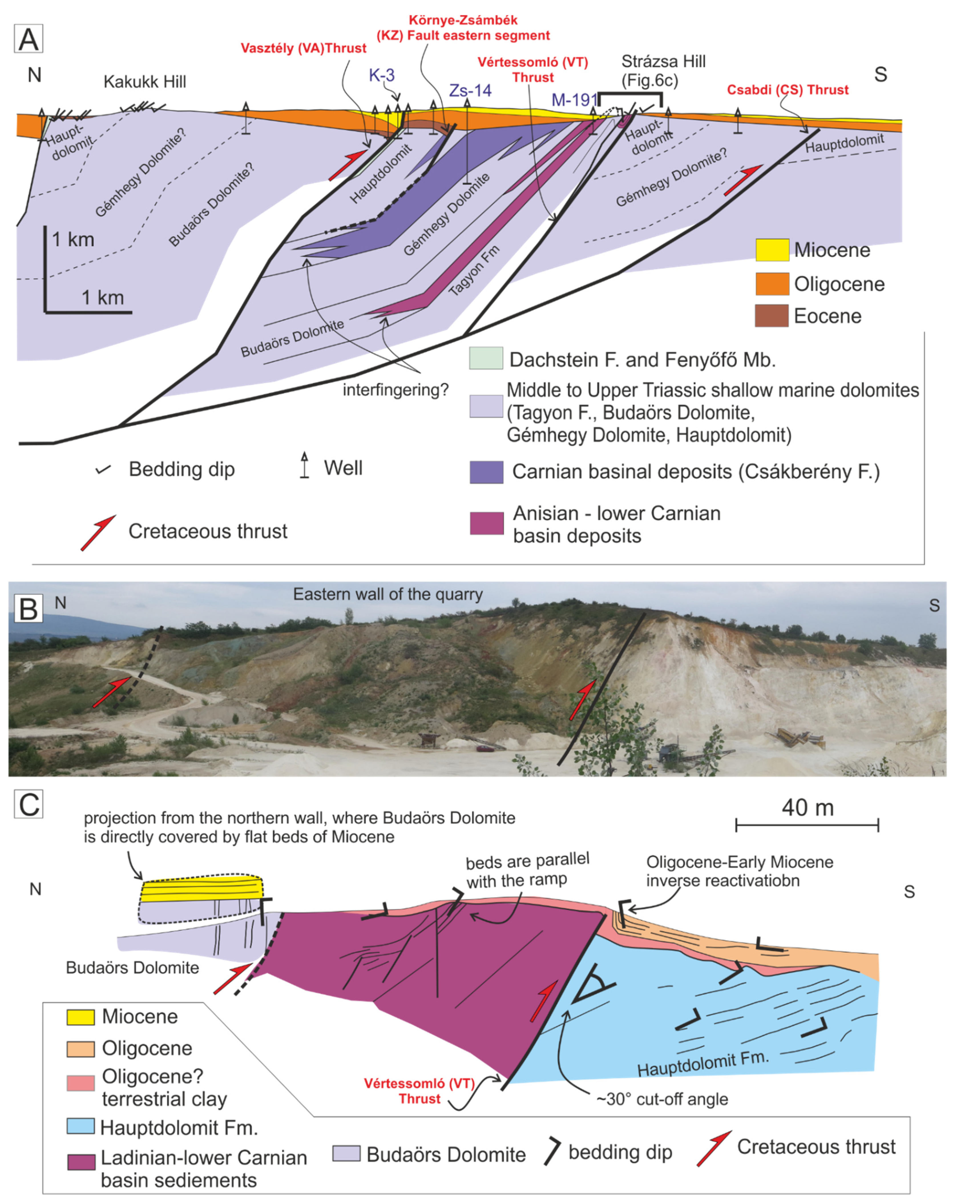
4.1. Structure of the Mesozoic Basement: Geometry of the Vértessomló (VT) Thrust

Triassic beds generally dip steeply northward (Figure 6A). In an early publication, Balla and Dudko [46] recognized several E-W trending belts of basin sediments within the platform carbonates that they interpreted as repetition due to strike-slip faulting. Although Budai et al. [34] supposed the south-directed imbrication of Triassic beds in the Zsámbék–Mány Basin, the exact geometry of the related structure has not been reconstructed yet. One of the most important thrusts, which is responsible for the northward tilting of the Triassic beds, is the Vértessomló (VT) Thrust, which is exposed in the Strázsa Hill quarry near Zsámbék town (Figure 4 and Figure 6) [34]. The Late Anisian to Ladinian Budaörs Dolomite and the Ladinian-early Carnian volcaniclastics of the Inota Fm. are thrust above the Norian Hauptdolomit in this quarry (Figure 6B,C). Based on our observations, the VT Thrust dips steeply (60°) towards the north in the quarry (Figure 6C). The Hauptdolomit dips moderately (25–30°) to the north in the footwall of the VT Thrust, so the cut-off angle of the thrust and the beds of the Hauptdolomit is approximately 30° (Figure 6C). The beds of the Inota Fm. are parallel to the VT Thrust (beds dip 60° toward the north) in the hanging wall of the thrust. The geometry of these beds indicates that the footwall ramp and the hanging wall flat of the VT Thrust are exposed in the quarry. Further north, the beds of the Inota Fm. turn to sub-horizontal, and the northernmost part of the quarry is made up of the sub-vertical beds of the Budaörs Dolomite (Figure 6C). The contact of the basinal beds and the Budaörs Dolomite is represented by a minor breakthrough thrust, which cuts across the hanging wall syncline of the VT Thrust (Figure 6C). The footwall of the VT Thrust is discordantly covered by terrestrial clay and clastics of the Upper Oligocene [61], whereas the hanging wall of Budaörs Dolomite is covered directly by a Middle Miocene shallow marine succession [62] (Figure 6C). The Oligocene beds turn to sub-vertical near the VT thrust (Figure 6C).
The subsurface continuation of the VT Thrust and the associated E-W striking belts of the tilted basement formations can be traced west of the Strázsa Hill quarry based on well data (Figure 7). We describe and interpret these belts from south to north. Most of the boreholes penetrated shallow marine dolomites below Paleogene in the southern part of the study area, except the B-2 well, which penetrated the Fenyőfő Member. Based on our interpretation, the shallow marine dolomites north of the B-2 well are overthrust above the Fenyőfő Mb. due to another south-vergent thrust; the Csabdi (Cs) thrust. Probably this thrust is responsible for the northward tilting of the footwall of, and the VT Thrust itself, in the Strázsa Hill quarry (Figure 6).
Further northwest–north of Csabdi village–another E-W striking belt of Fenyőfő Mb. is outlined based on four wells (e.g., M-20, M-71, Figure 7). This occurrence of the Fenyőfő Mb. represents the highest stratigraphic unit of the footwall of the VT Thrust. North of this belt, shallow marine dolomites were drilled below Paleogene sediments that represent the hanging wall of the VT Thrust. Four wells between Mány and Zsámbék villages (e.g., M-165, M-317) penetrated a basinal succession of cherty limestones, tuffitic clays and marls in an E-W striking belt below the Paleogene sediments (Figure 7). We interpret these rocks as occurrences of the late Anisian–Early Carnian basin deposits in the hanging wall of the VT Thrust. South of this belt, Triassic shallow marine dolomites are drilled below Cenozoic strata, which we interpret as Hauptdolomit in the footwall of the VT Thrust (Figure 7), based on the analogy of the Strázsa Hill quarry (Figure 6).
North of the belt of the late Anisian–Early Carnian basin deposits, shallow marine dolomites occur below the Paleogene deposits. Further north, there is another E-W striking belt where cherty dolomites and limestones occur below Paleogene (e.g., M-219, M-174, Zs-14 in Figure 7). This belt corresponds to the Csákberény Fm., which represents the upper interval of Carnian intraplatform basin deposits [36,38]. Shallow marine dolomites, which were drilled north of the belt of the Csákberény Fm., are interpreted as the overlying Hauptdolomit. Further north, the Fenyőfő Mb. underlies Paleogene based on the well Szomor K-3 (Figure 7).
This distribution of well data outlines a northward tilted continuous succession from Middle Triassic up to the Fenyőfő Mb., in the hanging wall of the VT Thrust, which is discordantly covered by Paleogene deposits (Figure 6A and Figure 7). Both the late Anisian to lower Carnian basin deposits and the Carnian Csákberény Fm. pinch out westward between Mány and Vasztély villages, that we explain as the lateral interfingering of the Triassic platform carbonates and the Carnian basin deposits (Figure 7). North of the Szomor K-3 well, drillholes penetrated shallow marine dolomite again below Cenozoic formations. We suppose that the contact of the Fenyőfő Mb. and the shallow marine dolomite is due to another south-directed thrust that we refer to as Vasztély (Va) Thrust (Figure 6A and Figure 7).

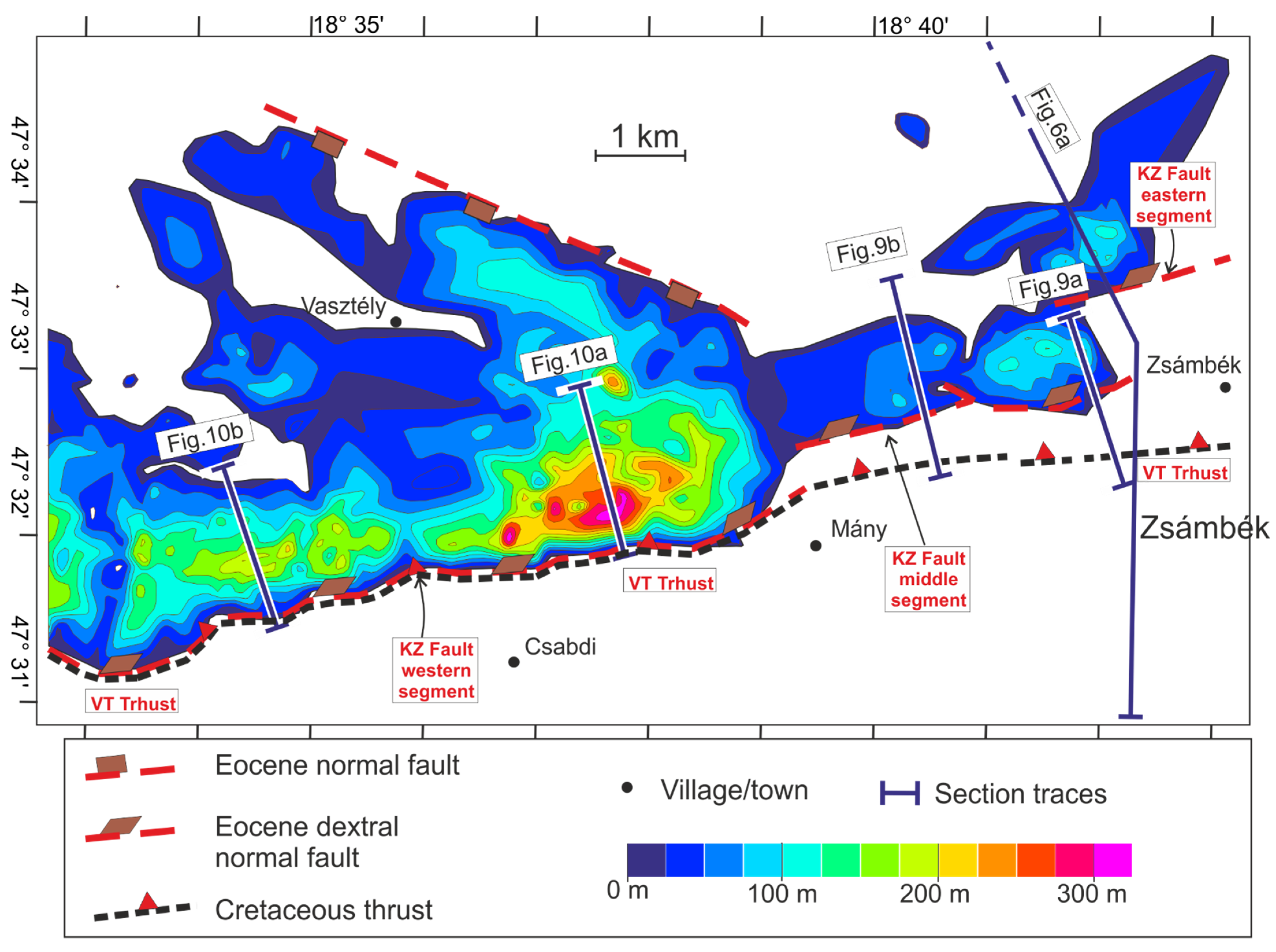
4.2. Basin-Bounding Faults of the Paleogene Deposits: The Környe-Zsámbék (KZ) Fault

The Környe-Zsámbék (KZ) Fault is clearly outlined on the Eocene thickness map (Figure 8): this fault represents the southern sharp contact between areas characterized by maximal Eocene thickness values and non-deposition areas [46]. The KZ Fault has three major segments in the study area. The WSW-ESE striking western segment of the KZ Fault coincides with the VT Thrust; therefore, we consider this segment as the reactivation of the VT Thrust (Figure 8).
The E-W striking middle segment of the KZ Fault runs parallel and approximately 1 km north of the VT Thrust (Figure 8 and Figure 9). Well data suggest the presence of a third segment, which represents the eastern segment of the KZ Fault (Figure 6A and Figure 8). This eastern segment runs 1 km north of the middle segment. Both the eastern and the middle segments of the KZ Fault follow stratigraphic contacts within the Triassic basement in map view. Namely, the middle and the eastern segments of the KZ Fault run along the lower and the upper stratigraphic contact of the Carnian Csákberény Fm., respectively (Figure 6 and Figure 7). The western tip-point of the middle segment of the KZ Fault is located exactly in the same area where the Csákberény Fm. pinches out and is laterally replaced by dolomite (Figure 8). West of this point, the Triassic basement is built up by a continuous succession of shallow marine dolomites in the hanging wall of the western segment of the KZ Fault.
The NNW-SSE striking cross-sections show a gradual thickening of Eocene succession toward the KZ Fault (Figure 9 and Figure 10). Overall, the Dorog Fm shows the most significant thickness variation, which indicates intense syn-sedimentary tectonics. The tectonic activity slowed down during the formation of coal-bearing layers (upper section of the Dorog Fm), and the rest of the Eocene succession onlaps onto the denudated Triassic towards the N (Figure 9 and Figure 10). The maximal thickness of Eocene succession is 200–350 m in the down-faulted block of the western segment. In most cases, the Eocene succession is missing, and the Triassic rocks are overlain directly by Oligocene deposits on the southern footwall block of the KZ Fault. This was already recognized by research on raw materials and some earlier maps [63]. An exception is the section of Figure 9a, where M-246 well- drilled thin remnants of the Eocene in the footwall of the KZ Fault. In this well, the coal-bearing layers (upper member of the Dorog Fm) deposited directly on the Triassic basement.
Interestingly, the thickness variation of the Oligocene succession shows an opposite trend with respect to the Eocene deposits. The Oligocene succession is gradually thinning from the north towards the KZ Fault on the NNW-SSE striking sections (Figure 9 and Figure 10); this feature is the most remarkable in the section of Figure 10A. In this section, the base-Eocene horizon is sub-horizontal, whereas the base-Oligocene horizon is north-dipping.
Based on the sections of Figure 9, the Oligocene is missing from the proximate hanging wall of the eastern part of the VT Thrust (south of the middle segment of the KZ Fault), and the Triassic is directly covered by Miocene. In contrast, the Triassic is overlain by thin Oligocene succession on the footwall of the VT Thrust (e.g., Zst-2 in Figure 9a, M-195 in Figure 9B).

4.3. Miocene Normal Faults

Our pre-Quaternary geological map (Figure 4) shows that the distribution of Triassic and Cenozoic sediments is strongly controlled by N-S to NNW-SSE striking normal faults (KH Fault, GH Fault, LF Fault), which represent the boundary between east-dipping blocks. These faults were active during the Late Miocene, evidenced by down-faulted Upper Miocene deposits next to Triassic rocks (Figure 4). Our WSW-ENE striking section (Figure 11) shows that the early Middle Miocene sediments occur mostly in the hanging wall blocks of these faults, whereas on the elevated blocks, the Middle Miocene is very condensed [52], or the Oligocene Mány Mb. is directly overlain by late Middle Miocene carbonates (Tinnye Fm.). Moreover, these NNW-SSE striking faults strongly controlled the depositional environment of the late Middle Miocene (Sarmatian) sediments: the uplifted blocks are dominated by the shallow-water carbonates of the Tinnye Fm. whereas mostly deep-water marls of the Kozárd Fm. deposited on the down-faulted blocks (Figure 11). Based on that, these N-S to NNW-SSE striking normal faults were active during the Middle to Late Miocene.

5. Discussion and Conclusions

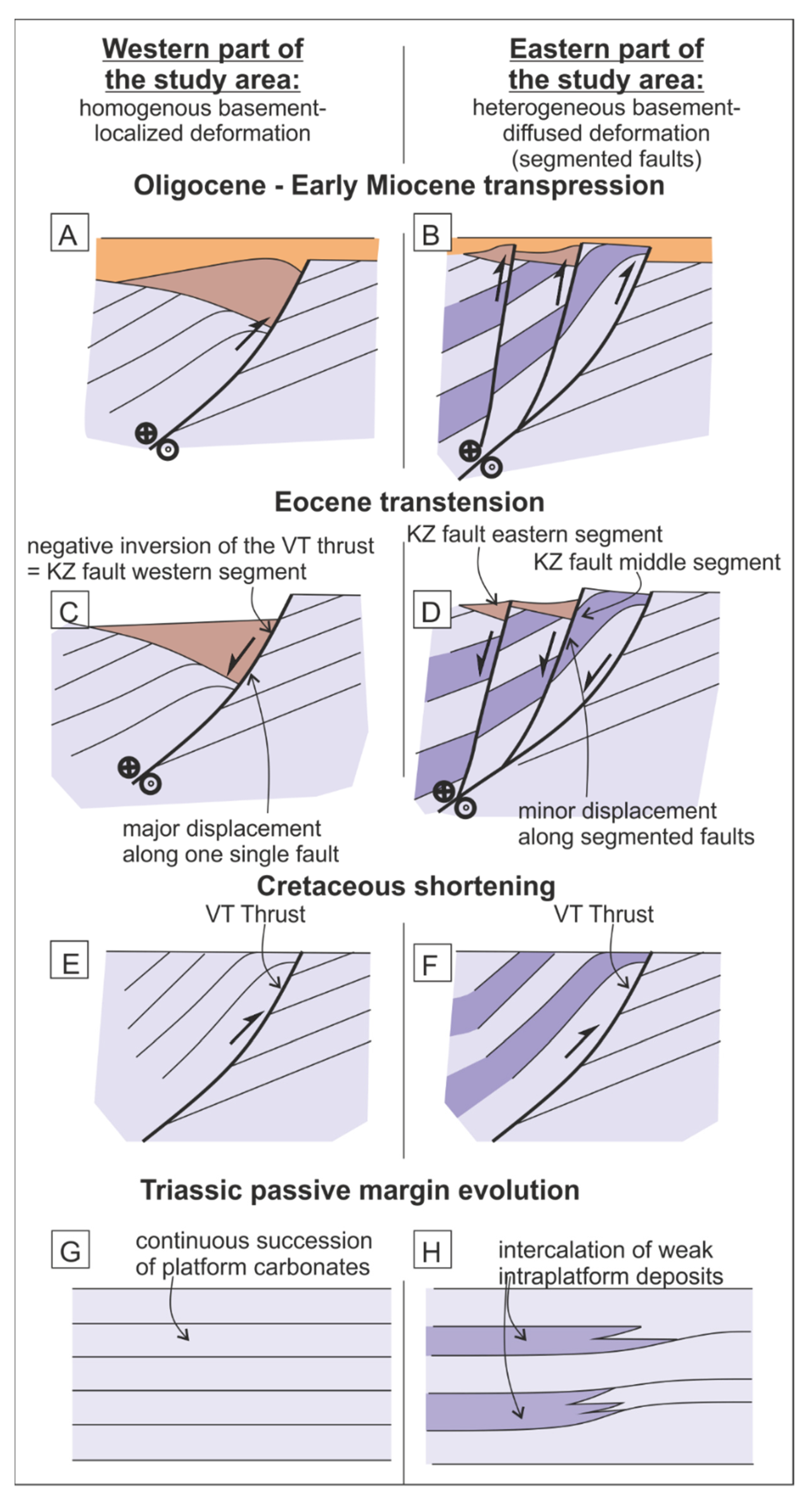
5.1. Correlation of the VT Thrust and the KZ Fault: Comparison with Previous Works

The recent distribution of Mesozoic and Cenozoic formations is primarily determined by Miocene extension-related grabens and half-grabens in the northeastern part of the Transdanubian Range. Our observations are in accordance with the findings of previous studies [58,59,60], which recognized the fault control on late Middle Miocene (Sarmatian) half-grabens. These grabens are bordered by NW-SE to N-S striking Miocene normal faults [64]. However, E-W striking faults, like the VT Thrust and the KZ Fault, also played a fundamental role in the deformation of Mesozoic and Paleogene deposits [46,50](Figure 2). The age and kinematics of these E-W striking faults are strongly controversial in previous works [46,48,49,65]. Fault segments with different ages and kinematics were correlated by previous studies [46], which is misleading in many cases.
The VT Fault was known for a long time in the Vértes Hills (as the “Somlyó-Szár fault” [45]), west of the study area (Figure 2). Maros [65] considered the VT Fault as a sinistral strike-slip fault based on structural data measured near the fault. Balla and Dudko [46] followed this concept: based on the apparent displacement of NNW-dipping Mesozoic formations; they considered the VT “line” as a sinistral strike-slip fault in the Vértes Hills. In addition, Balla and Dudko [46] correlated the VT Fault with the Nagykovácsi Fault in the Buda Hills (For the location, see Figure 2), which shows opposite, apparent dextral offset based on NE dipping dissected Triassic beds. According to Balla and Dudko [46]) the VT and Nagykovácsi Faults are connected by the Zsámbék Fault, which represents the southern limit of Eocene deposits in the study area (it is equivalent to the KZ Fault of this study). Balla and Dudko [46] explained the evolution of the Vértessomló-Nagykovácsi “line” by a complex model, where Oligocene dextral shear was followed by the bending and Miocene sinistral reactivation of the Vértessomló-Nagykovácsi Fault. Bada et al. [58] interpreted the Vértessomló-Nagykovácsi Fault as a Paleogene–Early Miocene dextral strike-slip fault based on detailed fault-slip analysis. Furthermore, they considered its activation during the Cretaceous with a dextral and/or reverse sense of shear.
In contrast to the model of Balla and Dudko [46], Császár [47] considered the VT Fault as a thrust based on the Vst-8 well (for location, see the western part of Figure 2), which penetrated the Aptian Tata Limestone juxtaposed to early Albian sediments. This interpretation was confirmed by the structural analysis of Fodor and Bíró [48]. Moreover, these authors found that the VT Thrust is covered by Eocene or Oligocene sediments in the Vértes Hills, and the displacement of Paleogene deposits does not occur along the VT Thrust but another fault that is running north at a low angle to the VT Thrust [21] (Figure 2). This fault was defined as the Környe-Zsámbék (KZ) Fault by Fodor [49]. The geometry of the VT Thrust and the KZ Fault is very similar in the Vértes Hills and in the eastern part of our study area, namely the eastern and middle segment of the KZ Fault–that controlled the Paleogene sedimentation–developed on the hanging wall of the pre-Eocene VT Thrust. In contrast, the western segment of the KZ Fault reactivates the VT Thrust in the study area (Figure 10).
The N-S striking sections (Figure 9 and Figure 10) show that the KZ Fault underwent a complex deformation history during the Paleogene. We explained the southward thickening of the Eocene beds by a syn-sedimentary normal slip of the KZ Fault (in section view) during the Eocene. This interpretation is in accordance with the section of Végné et al. [63], who illustrated the southern boundary fault of the Eocene deposits (equivalent to the KZ Fault) as a normal fault. Previous studies marked the KZ Fault as one single surface; in contrast, our study shows that the fault is laterally segmented. In addition to the E-W striking KZ Fault, a few NW-SE striking faults are outlined based on the thickness map of the Eocene (Figure 8). These faults were already mentioned by Véghné et al. [63], who considered these structures as the major basin-controlling faults of the Eocene sedimentation. Similar fault patterns with E-W and NW-SE striking syn-sedimentary faults were reconstructed in the Eocene Basin near Tatabánya (north of Vértes Hills) [66,67,68]. Bada et al. [58] reconstructed a strike-slip stress field for the Eocene, which can be characterized by WNW-ESE compression and perpendicular tension. Taking into consideration these fault-slip data [58], we suppose that the KZ Fault was acting as a dextral normal fault during the Eocene. In this stress field, the NW–SE striking faults could have normal kinematics.
According to Bada et al. [58], the Oligocene–Early Miocene stress field can be marked by NW-SE compression and NE-SW tension. In our opinion, the slight change of the maximal horizontal stress axis (Sh max) between Eocene and Oligocene resulted in the transition from transtension to transpression along the KZ Fault. We suggest that the gradual thinning of the Oligocene beds toward the KZ Fault is due to the dextral reverse reactivation of the KZ Fault, which occurred before the onset of Middle Miocene sedimentation. The geometry of the Eocene deposits outlines an asymmetric anticline in the section of Figure 10A, where the maximal thickness occurs in the core of this anticline. We interpret this anticline as an inversion anticline or harpoon structure (following the term of McClay [69]), which came into being during or after the deposition of the Oligocene but before the onset of Middle Miocene sedimentation. The lack of Oligocene on the hanging wall of the eastern part of the VT Thrust indicates its mild inverse reactivation during Oligocene–Early Miocene times. Taking into consideration the paleo stress data of Bada et al. [58], the VT Thrust acted as a dextral reverse fault during the Oligocene–Early Miocene. According to Véghné et al. [70], the Triassic is thrust over Paleogene in several wells west of the study area. They interpreted this juxtaposition as a south-directed post-Oligocene thrust (Csordakút Thrust), which probably belongs also to this deformation phase.
The Nagykovácsi Fault in the Buda Hills (for location, see Figure 2) is considered the eastern continuation of the VT Fault by several authors (“Vértessomló-Nagykovácsi line” [46]). Field observations indicate Late Eocene syn-sedimentary dextral transpressional movement on the Nagykovácsi Fault [25].

5.2. The Role of Fault Geometry and Rheology on Fault Reactivation

The 3D orientation of a fault plane relative to the principal stress axes has a fundamental role in fault reactivation [71,72,73]. Further controlling factors, such as the strain rate [12], the pore-fluid pressure in the fault zone [74], the frictional coefficient and the cohesion of the fault, also have a significant impact on fault reactivation [75,76]. Our data show that the high-angle dip of the VT Thrust (~60° in the Strázsa Hill quarry) contributed to both its transtensional and transpressional reactivation during the Eocene and Oligocene–Early Miocene, respectively.
Based on our results, the mode of fault reactivation is strongly controlled by the mechanical properties of the Triassic basement. Namely, the Eocene transtensional and Oligocene –Early Miocene transpressional deformation was localized along one single fault—the reactivated VT Thrust—in the western part of the study area, where the Triassic basement is represented by a homogenous succession of competent shallow marine dolomites (Figure 10 and Figure 12). In contrast, the Paleogene deformation took place in a wide zone of strike-slip faults (including the eastern and middle segment of the KZ Fault and the reactivated VT Thrust) in the eastern part of the study area, where the Triassic basement is more heterogeneous due to the intercalations of the incompetent Triassic intraplatform basin deposits (Figure 9 and Figure 12). Our observations are in accordance with the studies of Ferill et al. [77] and Libak et al. [78], which are based on field observations and seismic interpretation. According to these authors, the deformation of competent rocks resulted in a narrow, less segmented fault zone, which is manifested in one single laterally long fault. In contrast, the deformation of a layer-cake disposition of competent and incompetent rocks produces a wider, intensively segmented fault zone, where the individual fault segments are laterally short, and the segments have minor displacements. It is important to note that these observations are based on extensional normal faults which deform successions of horizontal beds [77,78]. Nevertheless, this relationship between fault geometry and rheology remains crucial in the study area, where the different mechanical properties of imbricated Triassic basement rocks (platform vs. intra-platform basin) resulted in the various geometries of Paleogene strike-slip faults (single fault vs. segmented fault-zone) even when crossing the already tilted successions and reactivating pre-existing faults.
The lateral segmentation of the KZ Fault–which formed during the Eocene–had a significant impact on the oblique (dextral) inversion of the KZ Fault during the Oligocene–Early Miocene (Figure 9A); the Eocene sediments were folded into a local inversion anticline during this time span. This inversion anticline is most remarkable above the relay ramp that connects the western and middle segments of the KZ Fault (Figure 10A). This stepover formed a restraining bend during the dextral transpressional reactivation of the KZ Fault, which supports the formation of this local inversion anticline. Similar strike-slip reactivation of segmented normal fault zones has been described by several authors, e.g., [79,80,81]. One of the most important features of inverted relay ramps that they form narrow (laterally short) zones of folds and thrusts [8,79], just like the inversion anticline of Figure 10a, which cannot be followed on the parallel sections (Figure 9B and Figure 10B).
The Middle to Late Miocene normal faults of the study area are almost perpendicular to the VT Thrust and the KZ Fault. However, this inherited fault system localized the relay ramps and lateral tip points of Miocene normal faults (Figure 4). Therefore, the VT Thrust and the KZ Fault influenced fault nucleation during the Miocene extensional deformation, too. Most probably, these inherited faults played as an active transfer fault during the Miocene.

Author Contributions

Conceptualization, G.H.H., S.K. and M.Y.N.; software, G.H.H. and M.Y.N.; data curation, Z.K.; writing—original draft preparation, G.H.H., Z.K., T.B., L.F. and M.Y.N.; writing—review and editing, Z.K., S.K., T.B. and L.F.; visualization, G.H.H. and M.Y.N.; fieldwork, G.H.H., Z.K., S.K., T.B., L.F. and M.Y.N.; founding, L.F. All authors have read and agreed to the published version of the manuscript.

Funding

The research was supported by the National Research, Development and Innovation Office (NKFIH), Hungary, Grant 134873. The APC was funded by ELKH Institute of Earth Physics and Space Science, Sopron, Hungary.

Acknowledgments

We are grateful to the guest editors (Enrico Tavarnelli, Rob W.H. Butler, and Paolo Pace) and two anonymous reviewers, for their constructive suggestions. Our work is a part of the “4D geological mapping and research of geological evolution and structure of Hungary” project of the Supervisory Authority of Regulatory Affairs.

Conflicts of Interest

The authors declare no conflict of interest.

References

  1. Peron-Pinvidic, G.; Fourel, L.; Buiter, S.J.H. The influence of orogenic collision inheritance on rifted margin architecture: Insights from comparing numerical experiments to the Mid-Norwegian margin. Tectonophysics 2022, 828, 229273. [Google Scholar] [CrossRef]
  2. Tavarnelli, E. Normal faults in thrust sheets: Pre-orogenic extension, post-orogenic extension, or both? J. Struct. Geol. 1999, 21, 1011–1018. [Google Scholar] [CrossRef]
  3. Tari, G.; Bada, G.; Beidinger, A.; Csizmeg, J.; Danišik, M.; Gjerazi, I.; Grasemann, B.; Kovác, M.; Plašienka, D.; Šujan, M.; et al. The connection between the Alps and the Carpathians beneath the Pannonian Basin: Selective reactivation of Alpine nappe contacts during Miocene extension. Glob. Planet. Change 2021, 197, 103401. [Google Scholar] [CrossRef]
  4. Maffione, M.; Thieulot, C.; van Hinsbergen, D.J.J.; Morris, A.; Plümper, O.; Spakman, W. Dynamics of intraoceanic subduction initiation: 1. Oceanic detachment fault inversion and the formation of supra-subduction zone ophiolites. Geochem. Geophys. Geosyst. 2015, 16, 1753–1770. [Google Scholar] [CrossRef] [Green Version]
  5. Beauchamp, W.; Barazangi, M.; Demnati, A.; El Alji, M. Intracontinental rifting and inversion: Missour Basin and Atlas Mountains, Morocco. AAPG Bull. 1996, 80, 1459–1482. [Google Scholar]
  6. Butler, R.W.H.; Tavarnelli, E.; Grasso, M. Structural inheritance in mountain belts: An Alpine–Apennine perspective. J. Struct. Geol. 2006, 28, 1893–1908. [Google Scholar] [CrossRef]
  7. Carrera, N.; Muñoz, J.A. Thick-skinned tectonic style resulting from the inversion of previous structures in the southern Cordillera Oriental (NW Argentine Andes). In Thick-Skin-Dominated Orogens: From Initial Inversion to Full Accretion; Nemčok, M., Mora, A., Cosgrove, J.W., Eds.; Geological Society, London, Special Publications: London, UK, 2015; Volume 377, pp. 77–100. [Google Scholar]
  8. Héja, G.; Ortner, H.; Fodor, L.; Németh, A.; Kövér, S. Modes of oblique inversion: A case study from the Cretaceous fold and thrust belt of the western Transdanubian Range (TR), West Hungary. Tectonics 2022, 41. [Google Scholar] [CrossRef]
  9. Mescua, J.F.; Gambiagi, L.B. Fault inversion vs. new thrust generation: A case study in the Malargüe fold-and-thrust belt, Andes of Argentina. J. Struct. Geol. 2012, 35, 51–63. [Google Scholar] [CrossRef]
  10. Pace, P.; Calamita, F. Push-up inversion structures vs. fault-bend reactivation anticlines along oblique thrust ramps: Examples from the Apennines fold-and-thrust belt (Italy). J. Geol. Soc. 2013, 171, 227–238. [Google Scholar] [CrossRef]
  11. Tari, G.; Arbouille, D.; Schléder, Z.; Tóth, T. Inversion tectonics: A brief petroleum industry perspective. Solid Earth 2020, 11, 1865–1889. [Google Scholar] [CrossRef]
  12. Butler, R.W.H. The influence of pre-existing basin structure on thrust system evolution in the western Alps. In Inversion Tectonics; Cooper, M.A., Williams, G.D., Eds.; Geological Society, London, Special Publications: London, UK, 1989; Volume 44, pp. 105–122. [Google Scholar] [CrossRef]
  13. Calamita, F.; Pace, P.; Scisciani, V.; Properzi, F.; Francioni, M. Dinaric up-thrusts in the Pliocene evolution of the Central Apennines thrust belt of Italy: The Montagna dei Fiori structure. Geol. Mag. 2021, 158, 2063–2078. [Google Scholar] [CrossRef]
  14. Pace, P.; Pasqui, V.; Tavarnelli, E.; Calamita, F. Foreland-directed gravitational collapse along curved thrust fronts: Insights from a minor thrust-related shear zone in the Umbria-Marche belt, central-northern Italy. Geol. Mag. 2017, 154, 381–392. [Google Scholar] [CrossRef]
  15. Tavarnelli, E.; Scisciani, V.; Patruno, S.; Calamita, F.; Pace, P.; Iacopini, D. The role of structural inheritance in the evolution of fold-and-thrust belts: Insights from the Umbria-Marche Apennines, Italy. In 250 Million Years of Earth History in Central Italy: Celebrating 25 Years of the Geological Observatory of Coldigioco; Koeberl, C., Bice, D.M., Eds.; GSA Special Papers; Geological Society of America: Boulder, CO, USA, 2019; Volume 542, pp. 191–211. [Google Scholar] [CrossRef]
  16. Avouac, J.-P.; Ayoub, F.; Wei, S.; Ampuero, J.-P.; Meng, L.; LePrince, S.; Jolivet, R.; Duputel, Z.; Helmberger, D. The 2013, Mw 7.7 Balochistan earthquake, energetic strike-slip reactivation of a thrust fault. Earth Planet. Sci. Lett. 2014, 391, 128–134. [Google Scholar] [CrossRef] [Green Version]
  17. Sato, H.; Kato, N.; Abe, S.; Van Horne, A.; Takeda, T. Reactivation of an old plate interface as a strike-slip fault in a slip-partitioned system: Median Tectonic Line, SW Japan. Tectonophysics 2015, 644–645, 58–67. [Google Scholar] [CrossRef]
  18. Palotai, M.; Csontos, L. Strike-slip reactivation of a Paleogene to Miocene fold and thrust belt along the central part of the Mid-Hungarian Shear Zone. Geol. Carpathica 2010, 61, 483–493. [Google Scholar] [CrossRef] [Green Version]
  19. Timar-Geng, Z.; Grujic, D.; Rahn, M. Deformation at the Leventina-Simano nappe boundary, Central Alps, Switzerland. Eclogae geol. Helv. 2004, 97, 265–278. [Google Scholar] [CrossRef]
  20. Schmid, S.M.; Fügenschuh, B.; Kounov, A.; Maţenco, L.; Nievergelt, P.; Oberhänsli, R.; Pleuger, J.; Schefer, S.; Schuster, R.; Tomljenović, B.; et al. Tectonic units of the Alpine collision zone between Eastern Alps and western Turkey. Gondwana Res. 2020, 78, 308–374. [Google Scholar] [CrossRef]
  21. Fodor, L.; Csontos, L.; Bada, G.; Gyorfi, I.; Benkovics, L. Tertiary Tectonic Evolution of the Pannonian Basin System and Neighbouring Orogens: A New Synthesis of Palaeostress Data; Geological Society, Special Publications: London, UK, 1999; Volume 156, pp. 295–334. [Google Scholar] [CrossRef]
  22. Tari, G. Alpine Tectonics of the Pannonian Basin. Ph.D. Thesis, Rice University, Houston, TX, USA, 1994; p. 501. [Google Scholar]
  23. Schmid, S.M.; Bernoulli, D.; Fügenschuh, B.; Matenco, L.; Schefer, S.; Schuster, R.; Tischler, M.; Ustaszewski, K. The Alpine-Carpathian-Dinaridic orogenic system: Correlation and evolution of tectonic units. Swiss J. Geosci. 2008, 101, 139–183. [Google Scholar] [CrossRef]
  24. Fodor, L.; Csillag, G.; Lantos, Z.; Budai, T.; Kercsmár, Z.S.; Selmeczi, I. Geological Map of the Vértes Hills; Geological Institute of Hungary: Budapest, Hungary, 2008. [Google Scholar]
  25. Fodor, L.; Magyari, A.; Fogarasi, A.; Palotás, K. Tertiary tectonics and Late Palaeogene sedimentation in the Buda Hills, Hungary. A new interpretation of the Buda Line. Földtani Közlöny 1994, 124, 129–305. [Google Scholar]
  26. Császár, G.; Csereklei, E.; Budai, T. Geological Map of Hungary Scale 1:100 000, L–34–14 Érd (Bicske); Geological Institute of Hungary: Budapest, Hungary, 2004. [Google Scholar]
  27. Budai, T.; Fodor, L.; Kercsmár, Z.; Lantos, Z.; Csillag, G.; Selmeczi, I. Geological Map of the Gerecse Mountains, 1:50 000; Mining and Geological Survey of Hungary: Budapest, Hungary, 2018. [Google Scholar]
  28. Wein, G. Budai-Hegység Fedetlen Földtani Térkép 1:25000 (Translated Title: Pre-Quaternary Geological Map of the Buda Hills); Geological Institute of Hungary: Budapest, Hungary, 1976. [Google Scholar]
  29. Haas, J.; Budai, T. Upper Permian—Triassic facies zones in the Transdanubian Range. Riv. Ital. Paleontol. Stratigrafia 1995, 101, 249–266. [Google Scholar]
  30. Haas, J.; Budai, T. Triassic sequence stratigraphy of the Transdanubian Range (Hungary). Geol. Carpathica 1999, 50, 459–475. [Google Scholar]
  31. Budai, T.; Vörös, A. The Middle Triassic events of the Transdanubian Central Range in the frame of the Alpine evolution. Acta Geol. Hung. 1993, 36, 3–13. [Google Scholar]
  32. Budai, T.; Vörös, A. Middle Triassic platform and basin evolution of the Southern Bakony Mountains (Transdanubian Range, Hungary). Riv. Ital. Paleontol. Stratigr. 2006, 112, 359–371. [Google Scholar]
  33. Budai, T. Middle Triassic basin facies and volcanites in the Zsámbék Basin, Transdanubian Range, Hungary. Annu. Rep. Hung. Geol. Inst. 2004, 2002, 189–194, (In Hungarian, with English abstract). [Google Scholar]
  34. Budai, T.; Haas, J.; Piros, O. New stratigraphic data on the Triassic basement of the Zsámbék Basin—Tectonic inferences. Földtani Közlöny 2015, 145, 247–257. Available online: https://ojs3.mtak.hu/index.php/foldtanikozlony/article/view/134 (accessed on 1 September 2015). (In Hungarian, with English abstract).
  35. Dunkl, I.; Farics, É.; Józsa, S.; Lukács, R.; Haas, J.; Budai, T. Traces of Carnian volcanic activity in the Transdanubian Range, Hungary. Int. J. Earth Sci. 2019, 108, 1451–1466. [Google Scholar] [CrossRef] [Green Version]
  36. Haas, J.; Budai, T. Stratigraphic and facies problems of the Upper Triassic in the Transdanubian Range. Reconsideration of old problems on the basis of new results. Földtani Közlöny (In Hungarian, with English abstract). 2014, 144, 445–468. [Google Scholar]
  37. Oravecz, J. A Gerecse–Buda–Pilis hegység közötti rögterület triász képződményei. (Translated title: Triassic formations of the horsts between the Gerecse, Buda and Pilis Hills). Földtani Közlöny 1961, 91, 173–185. (In Hungarian) [Google Scholar]
  38. Haas, J.; Oravecz, J.; Góczán, F. Jelentés a Zsámbék, Zs–14.sz. Alapszelvény Fúrás Vizsgálatáról. (Translated Tittle: Report of the Study of Zsámbék Zs-14 Well); Országos Földtani és Geofizikai Adattár: Budapest, Hungary, 1981; Volume 1656. (In Hungarian) [Google Scholar]
  39. Vörös, A.; Galácz, A. Jurassic palaeogeography of the Transdanubian Central Range (Hungary). Riv. Ital. Paleontol. Stratigr. 1998, 104, 69–84. [Google Scholar]
  40. Császár, G.; Árgyelán, G. Stratigraphic and micromineralogic investigations on Cretaceous Formations of the Gerecse Mountains, Hungary and their palaeogeographic implications. Cretac. Res. 1994, 15, 417–434. [Google Scholar] [CrossRef]
  41. Szives, O.; Fodor, L.; Fogarasi, A.; Kövér, S. Integrated calcareous nannofossil and ammonite data from the upper Barremian—Lower Albian of the northeastern Transdanubian Range (central Hungary): Stratigraphical implications and consequences for dating tectonic events. Cretac. Res. 2018, 91, 229–250. [Google Scholar] [CrossRef]
  42. Pocsai, T.; Csontos, L. Late Aptian—Early Albian syn-tectonic facies-pattern of the Tata Limestone Formation (Transdanubian Range, Hungary). Geol. Carpathica 2006, 57, 15–27. [Google Scholar]
  43. Sasvári, Á. Shortening-related deformation in the Gerecse Mts., Transdanubian Range, Hungary. Földtani Közlöny 2008, 138, 385–402, (In Hungarian with English abstract). [Google Scholar]
  44. Fodor, L.; Kercsmár, Z.; Kövér, S.Z. Structure and deformation phases of the Gerecse. In Geology of the Gerecse Mountains; Budai, T., Ed.; Mining and Geological Survey of Hungary,: Budapest, Hungary, 2018; pp. 370–386. ISBN 978-963-671-312-6. [Google Scholar]
  45. Taeger, H. A Vérteshegység földtani viszonyai (Translated tittle: Geology of the Vértes Hills). Magy. Királyi Földtani Intézet Évkönyve 1909, 17, 256p. (In Hungarian) [Google Scholar]
  46. Balla, Z.; Dudko, A. Large-scale Tertiary strike-slip displacements recorded in the structure of the Transdanubian Range. Geophys. Trans. 1989, 35, 3–63. [Google Scholar]
  47. Császár, G. An overview of the Cretaceous research in the Gerecse Mountains and the Vértes Foreland. Általános Földtani Szemle. 1995, 27, 133–152, (In Hungarian, with English abstract). [Google Scholar]
  48. Fodor, L.; Bíró, I. Abrasional Eocene rocky shore along the Cretaceous Vértessomló Thrust (Szarvas-kút, Vértes Hills, Hungary). Magy. Állami Földtani Intézet Évi Jelentése 2004, 2002, 153–162, (In Hungarian, with English abstract). [Google Scholar]
  49. Fodor, L. Structural geology. In Geology of the Vértes Hills. Explanatory Book to the Geological Map of the Vértes Hills 1:50000; Budai, T., Fodor, L., Eds.; Geological Institute of Hungary: Budapest, Hungary, 2008; pp. 282–300. [Google Scholar]
  50. Haas, J.; Budai, T.; Csontos, L.; Fodor, L.; Konrád, G. Pre-Cenozoic Geological Map of Hungary, 1:500 000; Geological Institute of Hungary: Budapest, Hungary, 2010. [Google Scholar]
  51. Tari, G.; Báldi, T.; Báldi-Beke, M. Paleogene retroarc flexural basin beneath the Neogene Pannonian Basin: A geodynamical model. Tectonophysics 1993, 226, 433–455. [Google Scholar] [CrossRef]
  52. Budai, T.; Fodor, L.; Sztanó, O.; Kercsmár, Z.; Császár, G.; Csillag, G.; Gál, N.; Kele, S.; Kiszely, M.; Selmeczi, I.; et al. Geology of the Gerecse Mountains—Regional Map Series of Hungary, Explanatory Book to the Geological Map of the Gerecse Mountains; Institute of Geology and Geophysics of Hungary: Budapest, Hungary, 2018; 491p. [Google Scholar]
  53. Handy, M.R.; Ustaszewski, K.; Kissling, E. Reconstructing the Alps—Carpathians—Dinarides as a key to understanding switches in subduction polarity, slab gaps and surface motion. Int. J. Earth Sci. 2015, 104, 1–26. [Google Scholar] [CrossRef] [Green Version]
  54. Ratschbacher, L.; Frisch, W.; Linzer, G.; Merle, O. Lateral extrusion in the eastern Alps, Part 2: Structural analysis. Tectonics 1991, 10, 257–271. [Google Scholar] [CrossRef]
  55. Royden, L.H. The tectonic expression of slab pull at continental convergent boundaries. Tectonics 1993, 12, 303–325. [Google Scholar] [CrossRef]
  56. Horváth, F.; Musitz, B.; Balázs, A.; Végh, A.; Uhrin, A.; Nádor, A.; Koroknai, B.; Pap, N.; Tóth, T.; Wórum, G. Evolution of the Pannonian basin and its geothermal resources. Geothermics 2015, 53, 328–352. [Google Scholar] [CrossRef]
  57. Balázs, A.; Burov, E.; Maţenco, L.; Vogt, K.; Francois, T.; Cloetingh, S. Symmetry during the syn- and post-rift evolution of extensional back-arc basins: The role of inherited orogenic structures. Earth Planet. Sci. Lett. 2017, 462, 86–98. [Google Scholar] [CrossRef]
  58. Bada, G.; Fodor, L.; Székely, B.; Timár, G. Tertiary brittle faulting and stress field evolution in the Gerecse Mountains, northern Hungary. Tectonophysics 1996, 255, 269–290. [Google Scholar] [CrossRef]
  59. Palotás, K. Synsedimentary Sarmatian fractures in the Tétény plateau. Földtani Közlöny 1994, 124, 207–210. [Google Scholar]
  60. Fodor, L.; Lelkes, G.; Müller, P.; Palotás, K. Előzetes jelentés a Budai-hg.—Gerecse-hg.—Vértes-hg. közötti területbBádeni és szarmata ősföldrajzi, szin- és poszttektonikai viszonyairól (Preliminary Report on the Relationship between the Middle Miocene Paleogeography and the Syn- and Post-Tectonic Deformations of the Area between the Gerecse, Vértes and Pilis Hills); Geological Institute of Hungary: Budapest, Hungary, 2000; 19p, Tekt. 757. [Google Scholar]
  61. Erdei, B.; Hably, L.; Héja, G.; Fodor, L. The late Oligocene macroflora of Zsámbék, central Hungary. Foss. Impr. 2022, 78, 298–309. [Google Scholar] [CrossRef]
  62. Kercsmár, Z.; Budai, T.; Szurominé Korecz, A.; Selmeczi, I.; Musicz, B.; Lantos, Z. Cenozoic formations of the Strázsa Hill at Zsámbék and its surroundings. Földtani Közlöny 2020, 150, 129–150, (In Hungarian, with English abstract). [Google Scholar] [CrossRef] [Green Version]
  63. Véghné Neubrandt, E.; Fáyné Tátray, M.; Mensáros, P.; Balásházy, L. A Nagyegyháza-mányi terület kőszénfekvő képződményeinek és alaphegységének földtani kérdései. (Translated tittle: Geology of the basement and the formations that underlying the coal in the Nagyegyháza-Mány area). Földtani Közlöny 1978, 108, 7–17. (In Hungarian) [Google Scholar]
  64. Jaskó, S. A Bicskei-Öböl Fejlődéstörténete, Hegyszerkezete és Fúrásai. (Translated title: Evolution, Structure and Wells of the Bicske Basin). Beszámoló a Magyar Királyi Földtani Intézet Vitaüléseinek Munkálatairól; Évi Jelentésének Függeléke 1943; A Magyar Királyi Földtani Intézet: Budapest, Hungary, 1943; Volume 5, pp. 254–302. (In Hungarian) [Google Scholar]
  65. Maros, G.Y. A Vértes hegységi Vitány-vár környékének tektonikai elemzése. (Translated title: Tectonic study of the Vitály castle area, Vértes Hills). Annu. Rep. Geol. Inst. Hung. 1988, 1986, 295–310. (In Hungarian) [Google Scholar]
  66. Kercsmár, Z.; Fodor, L. Syn-sedimentary deformations in the Eocene Tatabanya Basin, Central Hungary. Geolines 19. In Proceedings of the 3rd Meeting of the Central European Tectonics Studies Grou, Felsőtárkány, Hungary, 14–17 April 2005; pp. 60–61. [Google Scholar]
  67. Kercsmár, Z.; Fodor, L.; Pálfalvi, S. Tectonic control and basin evolution of the Northern Transdanubian Eocene Basins (Vértes Hills, Central Hungary). In Proceedings of the 4th Meeting of the Central European Tectonic Studies Group/11 Meeting of the Czech Tectonic Studies Group/7 Carpathian Tectonic Workshop, Zakopane, Poland, 19–22 April 2006; Geolines 20. pp. 64–66. [Google Scholar]
  68. Bergerat, F.; Geyssant, J.; Lepvrier, C. Neotectonic outline of the Intra-Carpathian basins in Hungary. Acta Geologica Hungarica 1984, 27, 237–251. [Google Scholar]
  69. McClay, K.R. The geometries and kinematics of inverted fault systems: A review of analogue model studies. In Basin Inversion; Buchanan, J.G., Buchanan, P.G., Eds.; Geological Society of London Special Publications: London, UK, 1995; Volume 88, pp. 97–118. [Google Scholar] [CrossRef]
  70. Véghné, S.; Kovács, J.; Mensáros, P. Rátolódás a Csordakút-II bauxitlencse területén. (Translated title: Thrust in the area of Csordakút-II bauxite occurrence). Földtani Közlöny 1987, 117, 93–99. (In Hungarian) [Google Scholar]
  71. Gillcrist, R.; Coward, M.P.A.; Mugnier, J.L. Structural inversion and its controls: Examples from the Alpine foreland and the French Alps. Geodin. Acta 1987, 1, 5–34. [Google Scholar] [CrossRef]
  72. Sassi, W.; Colletta, B.; Balé, P.; Paquereau, T. Modelling of structural complexity in sedimentary basins: The role of pre-existing faults in thrust tectonics. Tectonophysics 1993, 226, 97–112. [Google Scholar] [CrossRef]
  73. Bello, S.; Andrenacci, C.; Cirillo, D.; Scott, C.P.; Brozzetti, F.; Arrowsmith, J.R.; Lavecchia, G. High-detail fault segmentation: Deep insight into the anatomy of the 1983 Borah Peak earthquake rupture zone (Mw 6.9, Idaho, USA). Lithosphere 2022, 2022, 8100224. [Google Scholar] [CrossRef]
  74. Sibson, R.H. Rupturing in overpressured crust during compressional inversion— The case from NE Honshu, Japan. Tectonophysics 2009, 473, 404–416. [Google Scholar] [CrossRef]
  75. Ruh, J.B. Effects of fault-weakening processes on oblique intracontinental rifting and subsequent tectonic inversion. Am. J. Sci. 2019, 319, 315–338. [Google Scholar] [CrossRef]
  76. Granado, P.; Ruh, J. Numerical modelling of inversion tectonics in fold-and-thrust belts. Tectonophysics 2019, 763, 14–29. [Google Scholar] [CrossRef]
  77. Ferrill, D.A.; McGinnis, R.N.; Morris, A.P.; McGinnis, R.N.; Smart, K.J.; Wigginton, S.S.; Hill, N.J. Mechanical stratigraphy and normal faulting. J. Struct. Geol. 2017, 94, 275–302. [Google Scholar] [CrossRef]
  78. Libak, A.; Torabi, A.; Alae, B. Normal Fault Geometric Attribute Variations with Lithology: Examples from the Norwegian Barents Sea; Geological Society, London, Special Publications: London, UK, 2019; Volume 495. [Google Scholar] [CrossRef]
  79. De Vicente, G.; Vegas, R.; Muñoz-Martín, A.; Van Wees, J.D.; Casas-Sáinz, A.; Sopeña, A.; Fernández-Lozano, J. Oblique strain partitioning and transpression on an inverted rift: The Castilian Branch of the Iberian Chain. Tectonophysics 2009, 470, 224–242. [Google Scholar] [CrossRef] [Green Version]
  80. Zampieri, D.; Massironi, M. Evolution of a poly-deformed relay zone between fault segments in the eastern Southern Alps, Italy. In Tectonics of Strike-Slip Restraining and Releasing Bends; Cunningham, W.D., Mann, P., Eds.; Geological Society, London, Special Publications: London, UK, 2007; Volume 290, pp. 351–366. [Google Scholar]
  81. Rotevatn, A.; Peacock, D.C.P. Strike-slip reactivation of segmented normal faults: Implications for basin structure and fluid flow. Basin Res. 2018, 30, 1264–1279. [Google Scholar] [CrossRef]
Figure 1. The position of the study area within the Pannonian Basin ([20] modified) fault pattern is based on [21] NCA = Northern Calcareous Alps, TR = Transdanubian Range, MHZ = Mid-Hungarian Shear Zone. The abbreviations “Fig.” refer to figures of this work.
Geosciences 12 00433 g001
Figure 2. Pre-Quaternary geological map of the northeasternpart of the Transdanubian Range based on the maps of [24,25,26,27,28]. KZ = Környe-Zsámbék Fault, VT = Vértessomló Thrust, Nk = Nagykovácsi Fault, Vg = Várgesztes Fault, Bö = Budaörs Fault. For the position of the map within the Pannonian Basin, see Figure 1. The abbreviations “Fig.” refer to figures of this work.
Geosciences 12 00433 g002
Figure 3. Stratigraphy of the Triassic basement of the study area. Light lilac and pale green colors indicate the dolomitized and partly or non-dolomitized competent platform carbonates, respectively. Purple and dark lilac colors indicate the weak Anisian–Early Carnian and Carnian intra-platform basin deposits, respectively. Grey columns indicate the stratigraphic position of key outcrops/wells [33,34,35,36,37].
Geosciences 12 00433 g003
Figure 4. Position of well data and cross-sections on the pre-Quaternary geological map of the Zsámbék-Mány Basin. For the position of the map within the northeastern part of the Transdanubian Range, see Figure 2. Abbreviation of the faults: GH Fault: Góré Hill Fault; KH Fault: Kakukk Hill Fault; LF Fault: Lófingató Hill Fault; KZ Fault: Környe-Zsámbék Fault. The abbreviations “Fig.” refer to figures of this work.
Geosciences 12 00433 g004
Figure 5. Cenozoic stratigraphy of the study area. The abbreviations “Fig.” refer to figures of this work.
Geosciences 12 00433 g005
Figure 6. (A) N-S striking cross section across the study area, showing the imbrication of Triassic formations. For the trace of the section, see Figure 4. (B) Photo of the eastern wall of the Strázsa Hill quarry, where the VT Thrust is exposed. (C) Geological cross-section along the eastern wall of the quarry. For the location of the outcrop, see Figure 5 and Figure 7. The abbreviations “Fig.” refer to figures of this work.
Geosciences 12 00433 g006
Figure 7. Pre-Cenozoic geological map of the study area (for the location of the map within the Zsámbék–Mány Basin, see Figure 4). (A) Position of well data and section traces. The well data are filtered for the topmost Mesozoic picks. Note that most of the Middle to Late Triassic platform carbonates underwent fabric destructive dolomitization, which makes the differentiation of these formations very difficult. Therefore we illustrated these dolomites as one unit. (B) Position of major faults. The Vértessomló (VT) Thrust and the Környe-Zsámbék (KZ) Fault are illustrated by the cut-off line of the faults and the base-Eocene horizon in this figure. Therefore the traces of these faults differ in Figure 7 and Figure 8. Abbreviations of the faults: CS Thrust: Csabdi Thrust; VA Thrust: Vasztély Thrust; GH Fault: Góré Hill Fault; KH Fault: Kakukk Hill Fault; LF Fault: Lófingató Hill Fault. The abbreviations “Fig.” refer to figures of this work.
Geosciences 12 00433 g007
Figure 8. Eocene thickness map of the study area. Eocene sediments were not preserved in white areas. The KZ Fault and the VT Thrust are illustrated by the cut-off line of these faults and the base-Oligocene horizon. Therefore the traces of these faults differ in Figure 7 and Figure 8. For the location of the map within the Zsámbék–Mány Basin, see Figure 4. The abbreviations “Fig.” refer to figures of this work.
Geosciences 12 00433 g008
Figure 9. Sections across the middle segment of the KZ Fault. (A) Section across the eastern part of the middle segment of the KZ Fault. (B) Section across the western part of the middle segment of the KZ Fault. For location of the sections, see Figure 4. The abbreviations “Fig.” refer to figures of this work.
Geosciences 12 00433 g009
Figure 10. Sections across the western segment of the KZ Fault. (A) Section across the eastern part of the western segment of the KZ Fault. (B) Section across the western part of the western segment of the KZ Fault. For the location of the section, see Figure 4. The abbreviations “Fig.” refer to figures of this work.
Geosciences 12 00433 g010
Figure 11. ENE-WSW striking cross-section across the Zsámbék–Mány Basin; for the location of the section, see Figure 4. Note the along-strike variation of the connection between KZ Fault and VT Thrust. In the West, there is only one fault plane, showing the Eocene reactivation of the Cretaceous thrust, while there are two separate fault planes in the East. This change in reactivation style shows a positive correlation with the lateral change in Triassic rheology: massive platform carbonates on the west versus less competent basin intercalations on the east. The strike of major Miocene normal faults (LF, GH, KH Faults) is perpendicular to the section. The abbreviations “Fig.” refer to figures of this work.
Geosciences 12 00433 g011
Figure 12. Schematic idealized cross-sections showing the structural evolution of the western (A,C,E,G) and eastern (B,D,F,H) part of the study area. The Eocene transtensional (C,D), and Oligocene–Early Miocene transpressional (A,B) deformations reactivated the Cretaceous VT Thrust (E,F). The mode of fault reactivation was controlled by the rheology of the Triassic basement (G,H). Diffuse fault zone developed in the eastern part of the study area, where incompetent basin formations occur in the Triassic basement (B,D,F,H). The deformation was localized to a narrow zone in the west, where the Triassic basement is represented by homogeneous shallow marine carbonates (A,C,E,G).
Geosciences 12 00433 g012
Publisher’s Note: MDPI stays neutral with regard to jurisdictional claims in published maps and institutional affiliations.

