Abstract
The Pacific Island States and Territories are traditionally described as ‘small island’ nations. However, they are also ‘large ocean’ nations with jurisdiction over substantial maritime spaces stretching to at least 200 nautical miles. The article addresses issues related to baselines along the coast on which these broad maritime claims depend. The article then examines geodynamic considerations coupled with sea and land level projections in the Pacific leading to an assessment of the vulnerability or resilience of atolls in particular. The article then discusses potential implications for the coastlines and baselines of the Pacific Island States and Territories, the limits of their maritime entitlements and both delimited and undelimited maritime boundaries. Potential response options, prospects, and concluding thoughts are then offered.
1. Introduction
The Pacific Island States are often characterized as ‘small island’ states possessing limited land but are entitled to expansive maritime jurisdictional entitlements and are thus also ‘large ocean’ states. This scenario is essentially the result of the significant extension of national maritime claims offshore, coupled with the remote location of these states from both one another and their Pacific Rim neighbors. The Pacific small-island developing states (SIDS) comprise twelve independent states located in the western and central Pacific Ocean: the Federated States of Micronesia (FSM), Fiji, Kiribati, Marshall Islands, Nauru, Palau, Papua New Guinea (PNG), Samoa, Solomon Islands, Tonga, Tuvalu, and Vanuatu. Additionally, two states, Cook Islands and Niue, are freely associated with New Zealand whilst another territory, Tokelau, is dependent on New Zealand. Further, there are a number of territories dependent on or in free association with extra-regional metropolitan powers such as France (French Polynesia, New Caledonia, Wallis, and Futuna), the United Kingdom (Pitcairn Islands), and the United States (American Samoa, Guam, and Northern Mariana Islands) [1] (pp. 187–208) (see Figure 1).
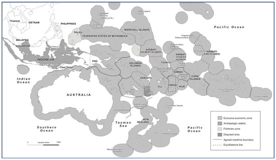
Figure 1.
Pacific maritime limits and boundaries.
Taken altogether, the Pacific Island States total just over 550,000 km2 of land (with Papua New Guinea comprising 84 per cent of this area). These islands are scattered over the vast 165 million km2 Pacific Ocean, which encompasses around one third of the surface of the earth [1,2]. The remote location of the Pacific Island States from their maritime neighbors means that they have enormous claims to maritime jurisdiction, encompassing an estimated area of 30,569,000 km2 (approximately equivalent to the land area of the African continent) [3] (pp. 144–157).
The United Nations Convention on the Law of the Sea (LOSC) of 1982 provides the fundamental international legal framework for claims to maritime jurisdiction. Such maritime claims are predominantly measured from a coastal state’s baselines, notably 12 nautical mile (M) breadth territorial seas and 200 M limited exclusive economic zones (EEZs) (see Figure 2).
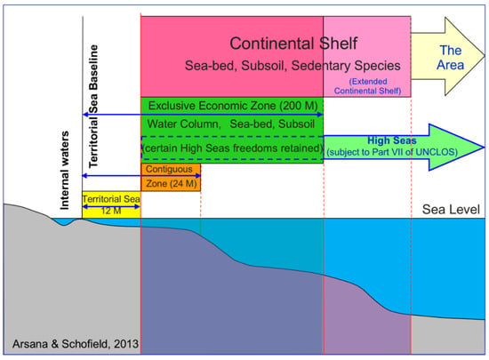
Figure 2.
Baselines and maritime zones [4].
The default and thus predominant type of baselines provided for under Article 5 of the LOSC are ‘normal’ baselines that are coincident with ‘the low-water line along the coast as marked on large-scale charts officially recognized by the coastal state’. Normal baselines are effectively a coastal state’s default baselines, as they do not need to be expressly claimed unlike other types of baselines provided for under LOSC, merely ‘marked on large scale charts officially recognized by the coastal state’. Coastlines are dynamic and as normal baselines coincide with the low-water line, they have traditionally been viewed as being able to move or ‘ambulate’ over time [5]. This can lead to related ‘knock-on’ shifts in the location of the outer limits of national maritime claims that are measured from such baselines. Thus, where the baseline advances, for instance as a consequence of sediment or volcanic deposit aggradation at the coast, or increased land areas due to tectonic uplift or isostatic rebounds, the outer limits of the maritime claims measured from that baseline will expand seawards. Conversely, where the normal baseline recedes because of inundation or erosion, or tectonic subsidence, the coastal state may lose maritime areas as the outer limits of their maritime zones are pulled back. The shifting of the low-water line would also affect the location of other types of straight-line baselines, as these baselines are still dependent on the location of normal baselines as they need to be connected to, or anchored to, points on or above the low-water line along the coast such that each system of straight-line baselines is ‘closed’ [6]. This applies to the archipelagic baseline systems defined by Pacific Island States including those of Fiji, Kiribati, Marshall Islands, Papua New Guinea, the Solomon Islands, and Tuvalu. The same concern also arises with respect to the baseline systems of proximate larger archipelagic states such as Indonesia and the Philippines.
The threat posed by global sea level rise is of particular note here (see further below). Fundamentally, rising sea levels could potentially lead to substantial reductions in the scope of claims to maritime jurisdiction [7]. This is because the outer limits of maritime claims are delineated through distance measurements from baselines along the coast. Such outer limits are commonly constructed through the ‘envelope of arcs’ method [8] (see Figure 3). Consequently, it is the outermost points along the baseline that will be relevant to the limits of the maritime zones. Significant sea level rise therefore has the potential to pose a distinct threat to critical base points from which maritime zones are measured and thus the extent of national maritime jurisdictional claims of states possessing low elevation coasts [9].
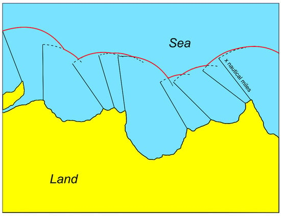
Figure 3.
Delineating the outer limits of maritime zones through an envelope of arcs [4].
2. Materials and Methods
There are numerous island types present in the Pacific including atolls, reef islands, volcanic islands, mountainous islands, disparate archipelagos, and limestone islands [10]. Within this diversity of insular features, certain Pacific Island States, notably those fully or predominantly comprised of low-elevation atoll and reef island features are potentially especially vulnerable to sea level rise. This poses the risk that substantial parts of low-lying Pacific Island States could potentially become submerged which, in turn, means there is a consequent threat of the retreat in the location of baselines and thus a significant reduction in the spatial extent of marine areas subject to national jurisdiction [11] (pp. 141–165). The article will review and evaluate the Pacific Island States coastlines with a view to categorizing their vulnerability to sea level rise and relate correlate this with their baseline and maritime claims as well as the status of their agreed and undelimited maritime boundaries with neighboring states. Multiple distinct scenarios involving agreed and unresolved maritime boundaries between Pacific States with analogous or differing levels of vulnerability are identified and illustrated through representative examples.
3. Sea and Land Level Changes in the Pacific Islands
3.1. Geodynamic and Geographical Setting of the Pacific Islands Region
From a geodynamic viewpoint, the Pacific Islands Region (Figure 1 and Figure 4) is dominated by ocean tectonics. The Pacific Plate is by far the largest plate in the region, with the smaller, but still large-scale Australian–Indian Plate occupying the southwestern parts of the region. The two plates meet at a long line of deep ocean trenches (up to c. 10 km deep) that can be seen in Figure 4 to extend NW-SE from the south side of Solomon Islands and Papua New Guinea (PNG) to west of Vanuatu, curving around to Fiji and Samoa, and then heading ESW through Tonga and ultimately to New Zealand. The meeting point of these two plates produces extensive subduction, which, in turn produces earthquakes and volcanoes that form up-raised island arcs (PNG islands, Solomon Islands, Vanuatu, Fiji, Tonga).
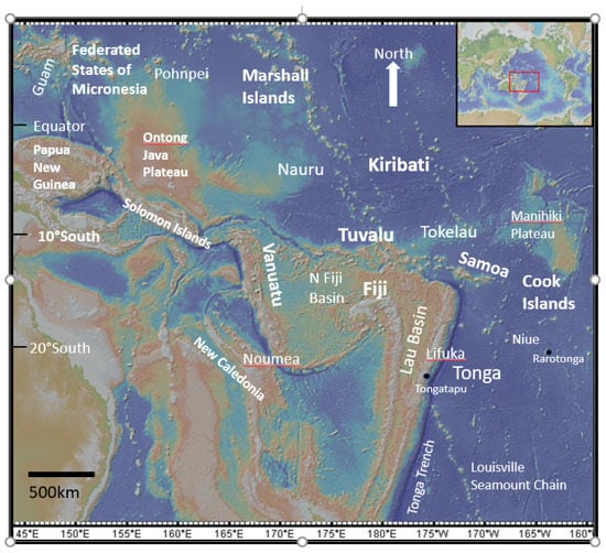
Figure 4.
Geodynamic and geographical setting of the Pacific Islands region. This Africa-sized region is located in the western part of the Pacific Ocean, either side of the equator. Inset shows the position of the region on a map of the Earth. The region is a dynamic geological area with a highly diverse set of oceanic tectonic features. Island arc nations such as Fiji, Solomon Islands, Vanuatu, Tonga, and the Papua New Guinea (PNG) islands are situated close to ocean trenches that mark subduction processes. These islands are higher volcanic islands. Atoll countries such as Cook Islands, Tuvalu, Kiribati, Federated States of Micronesia, Tokelau, and Marshall Islands form on extinct volcanic seamounts and can vary in elevation from just above sea level to raised elevations. Samoa, Louisville, and the Ontong Java and Manihiki Plateau are the products of deep-seated mantle plumes with the extensive plateaus forming important components of maritime boundary submissions. New Caledonia and parts of PNG are formed from older continental material. Colors in the diagram represent topographic elevations with the deepest blues being the deepest ocean, (mainly 4–6 km beneath sea level, with trenches extending to c. 10 km beneath sea level), paler colors representing shallower parts of the ocean (ocean plateau and drowned continental shelves), and land masses such as Australia in pale green colors. Acknowledgements to Google Earth for the base map.
Many Pacific Islands are atoll islands that form on slowly submerging, dormant, volcanic seamounts. These types of islands include Cook Islands, Tokelau, Kiribati, Tuvalu, Marshall Islands, and the Federated States of Micronesia (FSM). Whilst many islands are just above sea level (true atolls), others are raised atolls, with high-mountainous, or more elevated interiors and ocean cliffs, such as Pohnpei and Kosrae (FSM), Niue, Tongatapu, (Tonga), and Rarotonga, (Cook Islands). Much of the region is formed of deep ocean plains or abyssal plains. These areas form 50% of the Earth’s surface and have an average depth of c. 4 km beneath sea level. Many steep-sided elevated seamounts are present on the ocean floor, which are volcanic in origin. Most are extinct volcanoes, which formed in a similar fashion to live or recently inactive hot spot plume volcanoes, such as at Louisville, and Samoa.
More extensive and expansive plume magmatism produce ocean plateaus such as the Ontong Java and Manihiki Plateaus (largest and second largest Ocean Plateaus in the world). These are upraised parts of the ocean floor occasionally breaking surface and forming small islands. Their continental-sized geographical extent mean that they play important roles for some countries when laying claim to maritime territorial boundaries (e.g., Cook Islands, Solomon Islands, PNG). Islands such as New Caledonia form from active fault tectonics, which pushes up parts of the ocean floor to form islands. Other parts of extensive elevated areas such as the N-S extending ridge south of New Caledonia are thinned and rifted parts of the continental crust [12].
3.2. Spectrum of Scenarios: Eustatic and Tectonic Force Interplay
It is well documented that global sea levels are rising, and have been doing so from at least 1900 (IPCC, 2021, Figure 5). This change is attributed predominantly to anthropogenic forcing through the release of greenhouse gases, which in turn are raising global temperatures. Thermal expansion of seawater and ice melt are, by far, the key causes of sea level rise, with increasing ice melt becoming the most dominant cause.
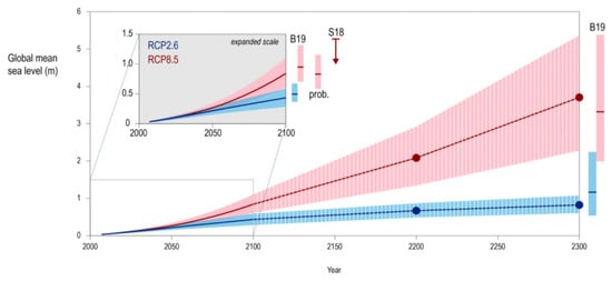
Figure 5.
Predicted global sea level rise (GMSL) to 2300. Projections relate to a range of Representative Concentration Pathway Emissions scenarios (RCP), which reflect global mean temperature increases of between 2 and 5 °C. See original reference for details re-probabilistic modeling shown as bars such as S18 and B19. Note the ranges in estimated sea level rises of c. 0.2–1 m in 2100, and 1.7–>5 m by 2300. Acknowledgements: IPCC and Cambridge University Press for the use of this figure [13].
The most recent statements from the Intergovernmental Panel on Climate Change [13] with respect to Global Mean Sea Level Rise (GMSL) indicate estimates based upon measured sea level rise rates (measured from tide gauges and altimetry measurements) of: 1.4 mm/year between 1901–1990; 2.1 mm/year between 1970–2015; 3.2 mm/year between 1993 and 2015; and 3.6 mm/year between 2006 and 2015. IPCC then project future sea level rises based on a range of Representative Concentration Pathway Emissions scenarios (RCP), which, in turn, lead to increasingly higher modeled global temperatures. The RCP scenarios from 2.6 to 8.5 would lead to global temperature rises of between 2 and 5 °C. The lower RCP scenarios (RCP = 2.6) are estimated to produce a GMSL rise of 0.43 m (0.29–0.50 m range), whilst the higher RCP scenarios (RCP = 8.5) are estimated to produce a GMSL rise of 0.84 m (range 0.61–1.10 m) by the year 2100 (medium confidence). Antarctic melting alone will lead to increased GMSL of 28 cm by the year 2100. Sea level rise rates are predicted to change from 1–2 mm/year over the past century, and 3–4 mm/year today, to between 4–9 and 10–20 mm/year, by the year 2100, under RCPs 2.6 and 8.5, respectively. Uncertainty over the next 30 years is relatively small with respect to predictions. By 2050 GMSL will rise between 0.24 (0.17–0.32 m range) and 0.32 m (0.23–0.40 m range) under RCPs 2.6 and 8.5, respectively.
Figure 5 summarizes predictions for sea level rise using a range of RCP scenarios from 200 to 2300 [13]. The main conclusions to draw from this diagram are: (1) predicted sea level rises are between c. 0.2–1 m in 2100, and 1.7–>5 m by 2300; and (2) the rates of sea level rise are increasing year by year with only the lower RCP scenarios suggesting a lowering of annual rates in sea level rise after c. 2200. These predictions form the backdrop to discussions of Pacific sea level rise below.
The rise and fall in sea level or eustatic changes with geological time are well-documented [14], indicating gross variations in sea levels of around c. 500 m (400 m higher and >100 m lower than today’s sea level). The absolute positioning of land and sea is variable on a number of factors, alongside eustatic variations.
Figure 6 summarizes (with a Pacific Island focus) the range of situations that exist on Earth with respect to the relative positions of land and sea. Land (continents, islands) can uplift or subside, and sea levels can rise and fall. The full range of conditional factors that influence the relative rises and falls of land/sea but largely revolve around tectonic forces (e.g., relative forces at plate boundaries, mountain-building, the activity and volume of mid ocean ridges), climate change (e.g., presence/absence of major ice caps), astronomical factors (e.g., tides, Milankovitch cycles), and ocean basin factors (e.g., ocean-atmosphere interactions, ocean currents,). Figure 6 illustrates the four main scenarios: (1) rising sea levels and land subsidence; (2) rising sea levels and land uplift; (3) falling sea levels and land subsidence; and (4) rising sea levels and land uplift.
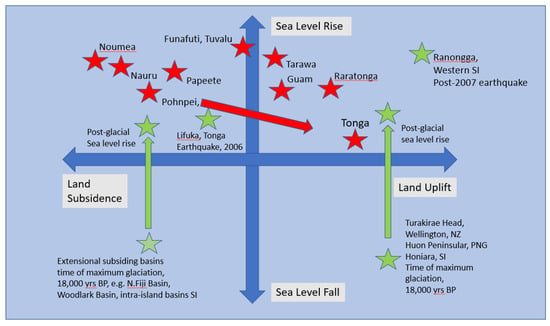
Figure 6.
Graphical representation of land subsidence/uplift versus sea level rise and fall for the SW Pacific Region. NB: this is for generic discussion purposes only and does not constitute predictive patterns. Throughout geological time a dynamic interplay has existed with respect to tectonic and eustatic movements. Green symbols display events/situations dominated by tectonic uplift/subsidence with sea level rise and fall superimposed. Red stars indicate post 1950 relative positions of islands with respect to measured GPS and tidal gauge land/sea altitude variations. Diagram informed by Becker et al. [15]; Ballu et al. [16]; SPC, [17]; Taylor et al., [18]. SI = Solomon Islands, PNG = Papua New Guinea.
Certain areas that experience long periods of overall uplift or subsidence. In the Pacific context for example, Turakirae Head, Wellington, New Zealand, Huon Peninsular Papua New Guinea, and Honiara Solomon Islands all experience uplift due to overall local tectonic convergence. In contrast, and North Fiji and Woodlark Basins, and intra-island basins within the main Solomon Islands archipelago have been largely submergent due to tectonic extension (see Figure 6). These areas sit within changing sea level environments, for instance caused by the glacial maximum of 18,000 years ago when sea levels were 120 m lower than the present time, and subsequent rising sea levels including todays anthropogenically forced sea level changes [11,19,20].
Moreover, areas such as Lifuka (Tonga) and Ranongga (Western Solomon Islands) have experienced earthquake-induced land subsidence and relative sea level land incursions and rapid land uplift with relative sea level retreat [16,17] (see Figure 6). More recently, data since 1950 with increasingly improving instrument resolution towards the present time record sea levels, for example from tide gauges and satellites, and land uplift/subsidence from GPS and satellite data [11,15]. These data give an overall pattern of sea level rise relative to land uplift/subsidence, even within the best-case scenarios of significant land uplift. Some islands, however, are more affected by anthropogenically forced sea level rise than others.
3.3. Geodynamics, Theories of Formation, and Character of Atolls
Charles Darwin famously first described atolls and developed the first classical model for atoll formation [21,22]. Darwin postulated that atolls form at a particular stage of the subsidence history of a subsiding ocean seamount. As large subaerial ocean volcanoes pass away from their magma source, they cool and subside. Whilst retaining a subaerial island component, extinct volcanoes, within tropical latitudes, form a ring of fringing coral reefs around the island (e.g., Rarotonga, Kosrae, Tahiti).
With time, the volcano subsides further, to the point where little or no volcanic rock lies above sea level. At this point, coral reefs and eroded coral sands and silts form the main geological deposit on top of the volcano. A series of arcuate-sinuous islands are built upon the highest areas of volcanic crater rims (e.g., Tarawa, Majuro, Kwajalein, Bikini atolls). Ultimately all that is visible above sea level are a series of low-lying islands (1 to c. 4 m above sea level), dominated by coral rock, sand, silt, and mud.
Alternate models of atoll formation take into account the c. 120 m sea level lowstand at the height of quaternary glaciations which would have produced many more Pacific Islands than we see today, followed by the mid-Holocene sea level highstand c. 5–2000 years before present [18,19]. During sea level lowstands, the carbonate platforms were subject to subaerial solution weathering, with the most resistant components of the reef forming residual, strong, upstanding topography. At times of higher sea levels, many present-day atolls were submerged, with maximum sea levels at c. 4000 years before present. As sea levels fell, islets formed through marine wave, wind, current and tidal activity, which eroded marine platforms, and constructed islets around higher, upstanding reef structures, through sediment deposition. Human occupation of Pacific atolls, Dickinson argues, occurred as ambient high tides fell below the levels of the main reef flats, leaving the islets within a subaerial environment. This occurred from c. 2600 to 1400 years before present.
Atolls comprise coralline rock and rubble, cemented to a volcanic rock foundation. Island geometries enclose a shallow lagoon, some tens of meters deep. Tidal sands, muds, rock fragments, and coral reefs cover the floor of the lagoon. The outer walls of the atoll often support a fringing reef that drops off quickly into the deep ocean, several kilometers deep. The islands themselves vary in height from less than a meter above sea level to perhaps 4 m above sea level, but mostly between 1–3 m above sea level. A freshwater lens forms within the upper parts of the atoll. The freshwater lens is usually only several meters thick, but may be tens to hundreds of meters long. The lens will vary in salinity depending on recent levels of rainfall, seawater intrusions into the aquifer, and hydrogeological factors.
3.4. Pacific Sea and Land Level Estimates
There exists broad consensus in the scientific community that global mean sea level is rising. For example, the Intergovernmental Panel on Climate Change (IPCC) suggests that global mean sea level rise in the period 2006–2015 has been two and a half times the rate for the period 1901–1990 [23]. IPCC estimated that under Representative Concentration Pathway (RCP) 8.5, corresponding to a high pathway for which radiative forcing reaches greater than 8.5 W m−2 by 2100 and continues to rise for some amount of time [22]. may pose potentially serious, maybe even disastrous, threats to many coastal states, especially those with large, heavily populated and low-lying coastal areas, and to small, low-lying island states [6]. Sea level rise is likely to lead to recessions in the location of coastlines and thus baselines along the coast.
These findings have been reinforced by elements of the IPCC’s Sixth Assessment Report (AR6) published in 2021 which found that global mean sea level (GMSL) rise had increased by 0.20 m between 1901 and 1918 and that the average rate of sea level rise had increased from 1.3 mm year−1 in the period 1901–1971 to 3.7 mm year−1 in 2006–2018 with human influence considered to be very likely to be the main driver for these changes. This report further indicated that not only is it ‘virtually certain’ that with high confidence GMSL will continue over the 21st century, but that ‘sea level is committed to rise for centuries to millennia and that it will remain elevated for thousands of years’ [13]. Further, with respect to small islands, the IPCC AR6 indicates that it is very likely that sea level rise will occur around such features together with storm surges and waves that are likely to ‘exacerbate coastal inundation with potential to increase saltwater intrusion into aquifers in small islands.’ As well as, with high confidence, shoreline retreat ‘along sandy coasts of most small islands’ [13].
With respect to sea level rise in the Pacific Ocean, global sea level rise could exceed two meters by 2100 [24], and that the rate of sea level rise is highest in the tropics. For example, the Pacific Marine Climate Change Report Card 2018 suggested that the Pacific Islands experienced sea level rise of 3–6 mm per year in the period 1993–2017. However, there were ‘some notable differences between islands’ with some islands in the Western Pacific (Solomon Islands, Papua New Guinea, and Marshall Islands) subjected to a higher rate of sea level rise (up to 6 mm/year) compared to islands further east (such as Samoa and Kiribati) [25].
Moreover, Becker et al. provide a comprehensive analysis of observed sea level change between 1950 and 2009 the West Pacific Region [15]. Data are derived from Global Positioning System (GPS), tide gauge, and satellite altimetry methods (the latter for more recent times). Overall, tide gauge measurements reveal an average rise in sea level of c. 1.7 mm/year and satellite altimetry data suggests 3.3 ± 0.4 mm per year (c. 3 times faster than global averages). Becker et al. also measure variations in vertical uplift/subsidence from a series of land-based GPS stations: These data are taken into account when constructed the Pacific Islands region sea level variations from 1950 to 2009 [15].
The worst-case scenario is a rapidly rising sea level coinciding with island subsidence or altitude-neutrality, as in the case of Tuvalu. The West Pacific sea level rise can be as high as 3 times that of global mean sea level rise, for the 1950–2009 period. The inter-decadal ENSO El Niño and La Niña cycles can lower/raise sea levels by 20–30 cm. The Tuvalu Region is identified as an area that has experienced particularly high levels of sea level rise relative (>5 mm/year). Becker et al. suggest that areas such as Rarotonga (Cook Islands), Pohnpei (Federated States of Micronesia), and Guam have experienced average or less than average sea level rise, with areas of highest sea level rise occurring in two distinct regions: from Papua New Guinea, eastwards through Honiara/Solomon Islands to Tuvalu and the Federated States of Micronesia/Marshall Islands in the North Pacific [11].
Ballu et al. concluded from a review of land-motion regional data for the SW Pacific region that, overall, the region is dominated by subsidence rates of −1.1 mm/year with variations on this figure of uplift rates up to 1.6 mm/year and subsidence rates of −5.4 mm/year [16]. Pohnpei and Tonga were two stations identified as demonstrated overall local uplift with Kiribati being another possibility (Figure 6 shows how differences in calculations between Becker et al., 2012 and Ballu et al., 2019 impact upon Pohnpei). Ballu et al. stress that their measurements and predictions probably have less impact in areas of high tectonic activity [16].
There are many examples that illustrate this dilemma, but Figure 4 illustrates two examples. The 2004 earthquake that lowered relative land levels over part of the island of Lifuka, Tonga, and therefore effectively increasing local relative sea levels, has been used as a case study for potential impacts of sea level rise in Pacific Islands [16]. The 2007 tsunamigenic earthquake in the Western Solomon Islands raised islands locally by up to 2 m, significantly reducing the potential impacts of anthropogenically induced sea level rise. Stepped ridge terranes rising to 100 s of meters above sea level in places such as the Huon Peninsular, Eastern PNG, or Mount Austen, Honiara, on Guadalcanal are evidence that, for millions of years, islands have mostly been uplifted. The data of Becker et al. 2012, Ballu et al., 2019, and others are invaluable, particularly for providing a backdrop to evaluating sea level rise impacts. However, these data must be set in context with active tectonics and factors such as island topography and geomorphology.
3.5. Atolls to Submerge by 2030–2050?
Atolls are often presented in the media, as well as much academic commentary, as fragile environments, soon to be drowned by the inevitable rise of the sea. Such observations become particularly salient in the aftermath of King Tides, which can inundate significant parts of atolls and are often used to ‘portend potential disaster futures’, with stories that focus on future island drowning scenarios [26].
Scientific discussion with respect to the future of atolls fall into two main camps. The predominant discourse shares the view of the media and most academic commentary, that is, that sea levels will rise so rapidly that, without interventions, atolls will be compromised as they become overwhelmed by rising seas. The timescale for this prediction varies from a few decades to a century or so [27,28] (see Figure 7).
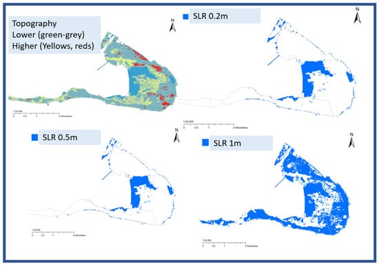
Figure 7.
Geospatial maps of South Tarawa Atoll, Kiribati. Top left diagram is a visual representation of topography with gray-blue colors representing lower land elevations (c. 1 m or less above sea level) and red-yellow colors higher land elevations (highest elevation c. 3.5 m above sea level). The map in the top right and lower maps are simple ‘bathtub rise’ models indicating the flooded land at Sea Level Rises (SLRs) of 0.2, 0.5, and 1 m (corresponding to lower IPCC-RCP estimates of sea level rises in 2050 of 0.2 m and higher IPCC-RCP sea level rise estimates of 1 m by 2100). Models such as these, coupled with IPCC predictions, suggest that South Tarawa and similar ocean atolls should plan for a range of scenarios that address environmental change in the coming decades [29].
An example of an atoll drowning prediction is presented by Storlazzi et al., who claim that atolls will become uninhabitable within decades [25,26]. This prediction is based on numerical modeling of the dynamic wave environment of NW Hawaiian atolls in the North Pacific. This research compares a passive ‘rising bathtub’ sea level rise modeling approach (Figure 7) with a dynamic wave modeling approach (taking into account wave and storm dynamics). Storlazzi and colleagues argue that as sea levels rise, the marine platforms surrounded reefs are increasingly subject to deeper submarine conditions. This reduces their ability to mitigate the energy of incoming waves. Hence, the island itself bears the main force of incoming waves. If realistic wave height models and climatic conditions such as reduced air pressures and strong winds are considered, it is predicted that the islands become inundated with even relatively small amounts of sea level rise (c. +1 m). More frequent inundations will allow salt water to regularly ingress into freshwater aquifers as well as causing erosion and general disturbance. Accordingly, Storlazzi et al. predict that Kwajalein atoll, Marshall Islands, and similar atolls, which are dependent on groundwater, will become uninhabitable by 2030–2040 [27]. By this time, annual floods will be so extensive and long lasting that there will be regular salinization of aquifers. The cumulate impacts of regular floods will make the groundwater unpotable as chloride levels rise above the maximum safe limit of drinking (250 micrograms/liter).
3.6. Resilient Atolls to Survive beyond 2100?
Alternative views are provided by Paul Kench and co-authors [19,30,31,32,33,34,35] alongside Pacific Islanders such as Biribo and Woodroffe [36]. These scholars contend that most atolls will still be present in 2100, and many islands will have grown in size. Kench and colleagues have shown from a study of historical atoll images over time, together with field studies, that atolls change shape, and dynamically evolve, but their overall areal extent remains unchanged, or has grown in size. They contend that many atoll islands are young in age: some as young as 2–5000 years old and that data examined over a 19–61-year period show a general trend of stability or modest island growth for c. 70% of studied islands.
There is a notable differential in findings in these studies between ‘urban’ and ‘natural’ atoll scenarios. Urbanized atolls such as South Tarawa (Kiribati) and Majuro (Marshall Islands), which contain c. 50% of the national populations of the countries concerned, necessarily change natural conditions. Increased urban atoll size change is largely due to human-induced activity with the building of key infrastructure and reclamation of land [34]. Urbanized island geo-engineering inevitably changes the system dynamics for the urban islands and their surroundings. Sediment availability and transport routes are often interrupted. Surrounding islands may be reduced in size in response to human interventions. Even the development of large villages with associated coastline interventions (e.g., groynes) can have impacts on the coastline, such as localized coastal erosion elsewhere along the coast of the insular features involved because of such interruptions to the ‘normal’ system.
A detailed study of the Funafuti atoll (Tuvalu) using map data extending back to the 19th century, for an atoll that has experienced one of the greatest relative sea level rises in the Pacific showed that some islands have decreased in size, but many were stable, or grew with time [32]. All islands present in the original 1897 survey remain above sea level. Whilst sand-dominated islands may reduce in size, mixed sand and gravel islands, particularly those within a sediment-rich reef platform tend to be more stable or accrete in size [30,32].
It has been observed that there is a possible movement of islands towards the lagoon side, which suggests that connectivity between the outside ocean and the interior lagoon is important for system-continuity [31,32]. This connectivity is often disturbed through the construction of inappropriately designed bridges and causeways that connect urbanized islands, and do not allow a free-passage for ocean currents and tides. A key factor in the persistence of atolls over time is sediment availability. Many atolls were largely built when sea level was higher (c. 5–2000 years ago). The fall in sea levels from 4–2000 years ago has depleted sediment supply. Atolls have been supplied mainly from sediment transport between islands, or more extreme events, such as cyclones or tsunamis, that erode parts of atolls but also tend to build up the height of atoll interiors [28]. As sea levels rise again, Kench and colleagues argue that sediment supply could increase and the higher frequency of extreme weather events could be a constructive island-building process.
Fundamentally, each ocean-atoll environment must be considered in relationship to the variables that affect atolls. Variables include the overall ocean climate, wave type, wavelength, height and direction, tidal variations, ocean currents, wind direction/strength/variability, ENSO related variations, the geometry and particle-size composition of atolls and individual islands, local sea level rise rates, urbanization/human interventions, and sediment supply. The Tuvalu study [31] demonstrates that a detailed analysis of an atoll system within its individual oceanic environment is the key to determining a scientific prognosis of island shape/size and viability.
Mclean and Kench [32] begin to develop science into policy arguments that are critical of what they see as a ‘global consensus opinion’ that sea level rise inevitably means atoll drowning, or regular sea inundation, with a consequent Domesday policy of mass migration. Instead, an argument is presented that: (1) There is time to adapt with no short-term danger of island disappearance; (2) there are limits to the environmental carrying capacity of highly populated islands and this is an area worthy of serious consideration; (3) coastal development, sea defenses, land reclamation, and similar must be carefully considered, particularly with respect to their likely impacts on the ‘natural’ atoll dynamics; (4) outer islands should be studied as ‘control islands’ relative to urban centers; and (5) there may be a case for de-centralization and encouraging settlement of islands of lower population density.
4. Implications for Pacific Islands Coasts and Baselines
4.1. Implications for Pacific Island Coasts
As noted above, Pacific Island States and Territories are made up of a diversity of types of insular formation. Of particular concern in the context of sea level rise-related threats, a number of island states in the Pacific are entirely or predominantly composed of low-elevation coral atolls and related reef islands. These include the Marshall Islands and Tokelau (see Figure 8).
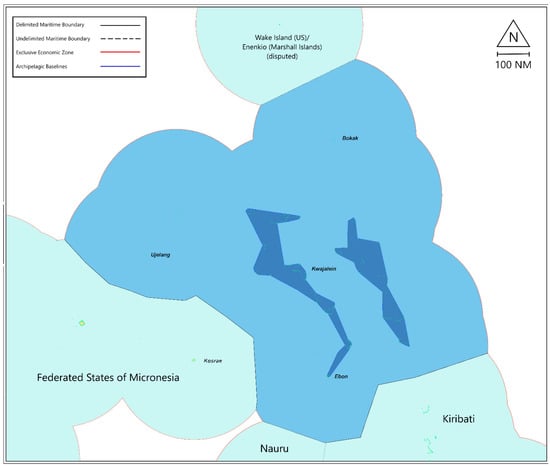
Figure 8.
Location of Marshall Islands’s atolls and islands, including claimed EEZ areas and boundaries, as well as Enenkio/Wake Island.
The Marshall Islands consists of 29 atolls and five isolated reef island features as well as the feature termed Enenkio by the Marshall Islands but known as Wake Island to the United States, which also claims sovereignty over the feature and administers it in practice (see Figure 8 above). Kiribati meanwhile consists of 32 atolls and reef island features together with one raised island feature, Banaba (Ocean) Island, of higher elevation. Additionally, Tokelau comprises three low-lying atoll island features (see Figure 9 below).
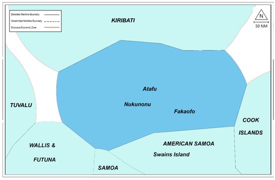
Figure 9.
Location of Tokelau’s atolls and islands, including claimed EEZ areas and boundaries.
While these the vulnerability of these states is arguably most acute, the coastline, and thus baseline stability, of most other Pacific Island States would also be implicated to varying degrees, even if they include some higher elevation islands. This, in turn, has implications for their potential maritime jurisdictional entitlements and their maritime boundaries with neighboring states (see below).
Pacific Island States, which possess some higher elevation islands as well as partially composed of low-lying reef features, are not in danger of complete inundation but can still be considered to be subject to high levels of vulnerability to sea level rise impacts. These include the Cook Islands and Federated States of Micronesia (FSM). With respect to the Cook Islands of its 15 islands, nine are low-lying atoll or reef island features with the remaining six being higher elevation features [37,38]. Indeed, around two-thirds of the Cook Islands EEZ claims are dependent on low-lying atoll island features, namely, Penrhyn Atoll, Manihiki Atoll, Pukapuka Atoll, Suwarrow Atoll, and Palmerston Atoll, all located in the northern part of the Cook Islands [36]. Concerning FSM, while there are high elevation features among each of the four major island groups making up the federation, Kosrae, Pohnpei, Chuuk, and Yap, numerous outlying and intervening low-elevation atoll and reef islands can be considered vulnerable to sea level rise. These include, from west to east, Ulithi Atoll, Eauripik Atoll, Pulusuk Atoll, Sapwuahfik Atoll, Minto Reef, and Kapingamarangi Atoll [36,39].
Similarly, the outlying atoll and reef island features of Fiji, Palau, Papua New Guinea (PNG), and the Solomon Islands. Similarly, the maritime claims associated with the Pacific territories of extra-regional states, including French Polynesia, New Caledonia, the United Kingdom’s overseas territory of the Pitcairn Islands as well as the Northwestern Hawaiian Islands and a number of U.S. remote Pacific Island territories including Howland and Baker Islands, Jarvis Atoll Johnston Atoll, Kingman Reef, Palmyra Island, and the aforementioned Wake Island/EnenKio, can be viewed as being particularly vulnerable to sea level rise impacts. Less at risk of substantial change are the coastlines and baselines of higher elevation island groups, often of volcanic origin, such as Nauru, Niue, Samoa, Tonga, and Vanuatu. This is not, however, to suggest that higher elevation islands will be immune to sea level rise impacts, as the majority of the population and the infrastructure on Pacific Islands is concentrated on the low-lying coastal fringes of such islands rather than the higher elevation core. Additionally, it can be anticipated that ecosystem services associated with coastal ecosystems will be negatively impacted under such a scenario.
4.2. Implications for Pacific Islands Baselines, Limits and Boundaries
Should atoll and coral reef coasts be subject to substantial change or even submergence in keeping with the scenarios outlined in Part 3.5 above, significant potential implications arise with respect to the baselines, maritime limits, and maritime boundaries of the states and territories concerned. This is because, as noted above, changes in the location of the coast necessarily results in alterations in the position of normal baselines coincident with low-water lines along the coast. Similarly, the seaward outer low-water line of reefs, forming baselines in keeping with Article 6 of the LOSC, may change. This can result in shifts in the delineation of the outer limits of maritime claims measured from such baselines. Here it can be observed that if the location of normal baselines does indeed change because of sea level rise or other natural processes, the 12 M territorial sea limits of all of the Pacific Island States may change. Similarly, the archipelagic baseline claims of Pacific Island States may be vulnerable [6].
These changes also have the potential to affect the other more expansive maritime zones, most notably the EEZ. All of the Pacific Island States and Territories to some extent rely on unilaterally delineated 200 M EEZ limits (see Figure 1), which would change following any changes to the baselines. The effects of these changes are less prominent when it comes to the continental shelf. Beyond 200 M from the coast, continental shelf limits are less dependent on distance, as they factor in geomorphological factors of the continental margin. The limits of continental shelf beyond 200 M are established in accordance with the recommendations of the United Nations Commission on the Limits of the Continental Shelf (CLCS), which would be ‘final and binding’ in keeping with LOSC, Article 76(8) [40].
As of 9 September 2021, there have been 88 submissions to the CLCS for a continental shelf beyond 200 M, eight of which were submitted individually or jointly by Pacific Island States [41]. Six of those submissions resulted or potentially resulted in an overlap between the outer continental shelf of the submitting state and the outer continental shelf or EEZ of their neighbors (Cook Islands, Micronesia, Papua New Guinea, Solomon Islands, Palau, and Tonga). Thus, after they received the recommendation from the CLCS, these states would need to negotiate boundaries for their continental shelf beyond 200 M with each other. Alternatively, such delimitation negotiations could proceed ahead of the coastal states concerned receiving recommendations from the CLCS on their outer continental shelf seawards of 200 M from baselines along the coast. However, the full extent of such continental shelf boundaries would only be determined once the delineation of outer continental shelf limits was achieved based on recommendations received from the CLCS, something that may well discourage states from adopting this approach.
Concerning maritime boundaries, equidistance lines have proved to be the most popular method of delimitation [42,43], which is also supported by international jurisprudence on maritime delimitation [44]. As the construction of an equidistance line depends on the location of the baselines of the coastal states involved, changes in the coastline and baselines could affect maritime boundary delimitation.
Given the diversity in coastlines and island characteristic among Pacific Island States, there exists for potential imbalances between more and less vulnerable neighboring Pacific States. There is likely to be minimal impact on maritime delimitation where relatively stable high-elevation features versus relatively stable high elevation features are present for both parties involved. Examples include the boundary delimited between PNG and the Solomon Islands in 1989 [45], and those yet to be delimited between Fiji and Tonga as well as between the Solomon Islands and Vanuatu. There are, however, scenarios where maritime boundaries are required between states comprised of relatively stable high-elevation features and those with potentially vulnerable/unstable features. Examples of this situation include the already agreed maritime boundaries between Cook Islands and Niue, Fiji, and Tuvalu, FSM and PNG, and FSM-USA (on behalf of Guam) (see Figure 10 below).
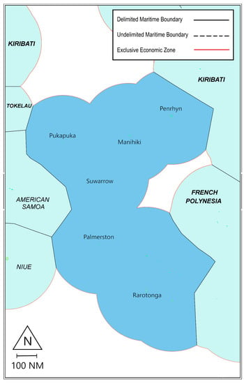
Figure 10.
Cook Islands’ claimed EEZ areas and boundaries.
For example, for the EEZ boundary between FSM and PNG, on the FSM side, the entirety of the equidistance-based line is controlled by basepoints located on Kapingamarangi, a large atoll on which 33 small islands are located (see Figure 11 below). These islands are located on the eastern side of the atoll, have a reported area of 0.521 square miles (0.84 km2), and are wooded and inhabited, while the western side of the atoll being described as ‘almost submerged’ at high water [36,37,46,47]. In contrast, the relevant features on the PNG side of the line are the numerous islands fringing the northern coast of New Ireland, many of which are of higher elevation [37]. This raises the possibility that should Kapingamarangi become fully submerged because of sea level rise, FSM land territory and basepoints would, in effect, disappear. Under such circumstances, the stability of the EEZ boundary between FSM and PNG may be open to challenge.
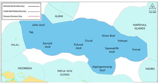
Figure 11.
Location of FSM’s atolls and islands, including claimed EEZ areas and boundaries.
Further, and arguably more problematically, this scenario exists for a number of undelimited maritime boundaries such as between France (New Caledonia) and Vanuatu and between Palau and Indonesia. Finally, maritime delimitation may involve potentially vulnerable features on both sides of the line. Many of these scenarios have already been delimited. Such as those between the Marshall Islands and FSM, as well as France (on behalf of French Polynesia) and the United Kingdom (on behalf of the Pitcairn Islands). Similarly, Kiribati and its neighbors the Cook Islands, Marshall Islands, and Tuvalu have agreed on their maritime boundary (see Figure 12 below).
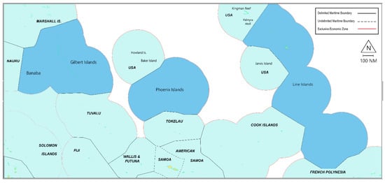
Figure 12.
Location of Kiribati’s atolls and islands, including claimed EEZ areas and boundaries.
It is, however, worth observing that with respect to the delimitation of maritime boundaries, remarkable progress has been achieved in recent years in the Pacific Islands Region with the number of maritime agreements doubling in the period 2006–2015 [48]. It is also of note in this context that international boundaries, including maritime boundaries, have a privileged status in the international law of treaties and are not subject to change even in the case of ‘subsequent fundamental change of circumstances’ [49]. This view has also been reinforced through international jurisprudence with the ruling in the 2014 arbitration case between Bangladesh and India indicating that ‘maritime delimitations, like land boundaries, must be stable and definitive to ensure a peaceful relationship between the states concerned in the long term’ [50].
Moreover, there is substantial development in the Pacific Region towards declaring, fixing and thus stabilizing baselines limits and maritime boundaries. In particular, in 2010 the Pacific Island Forum adopted the Framework for a Pacific Oceanscape. This regional oceans governance strategy includes a call for Pacific Island States and territories to deposit coordinates and charts delineating their maritime zones with the United Nations with a view to determine their maritime jurisdictions explicitly so that they ‘could not be challenged and reduced due to climate change and sea level rise.’ This objective has been backed up by successive declarations on the part of Pacific Islands leaders such as the Taputapuātea Declaration on Climate Change of 2015, Delap Commitment on Securing Our Common Wealth of Oceans of 2018 and the 2018 Boe Declaration on Regional Security, and the unanimous Communique of the 2019 Meeting of the Pacific Islands Forum [6]. The Pacific Islands Forum Leaders Ocean Statement 2021 reinforced these statements, where under the heading ‘Securing the Blue Pacific’ they declared that:
‘Recognizing the strategic importance and value of the Ocean and its peaceful use, we reaffirm our commitment to the rules-based international order founded on the UN Charter, adherence to the UN Convention on the Law of the Sea and resolution of international disputes by peaceful means.
Securing the limits of the Blue Pacific Continent against the threats of sea level rise and climate change is the defining issue underpinning the full realization of the Blue Pacific Continent. We are committed to concluding outstanding maritime boundaries claims and zones, including related treaties and legal frameworks to support the sustainable development and ensure the peace and security of our Blue Pacific Continent not only from environment threats but also from external geo-strategic interests. We are also committed to a collective effort, including to develop international law, with that aim of ensuring that once a Forum Member’s maritime zones are delineated in accordance with the 1982 UN Convention on the Law of the Sea, the Member’s maritime zones cannot be challenged or reduced as a result of sea level rise and climate change’ [51].
Additionally, the International Law Association (ILA) passed a Resolution in 2018 endorsing similar view. The ILA’s Committee on International Law and Sea Level Rise proposed the following view: On the grounds of legal certainty and stability, provided that the baselines and the outer limits of maritime zones of a coastal or an archipelagic state have been properly determined in accordance with the 1982 Law of the Sea Convention, these baselines and limits should not be required to be recalculated should sea level change affect the geographical reality of the coastline [52].
Also of relevance is the establishment of a study group on sea level rise in relation to international law by the International Law Commission in 2019. Nearly 120 UN Member States supported the inclusion of this topic in the ILC’s long-term program of work. Discussions on the implications of sea level rise for the law of the sea took place in October 2019 in the Sixth Committee of the UN General Assembly with several states proving to be supportive of an approach to ensure certainty and stability under the LOSC [6,53]. While these discussions are ongoing at the time of writing, they are suggestive of at least a measure of support for the approach of Pacific SIDS in terms of declaring and fixing their baselines, outer limits to their maritime claims, and maritime boundaries.
5. Conclusions
This article examined the dependence of the significant maritime entitlements of Pacific Islands States and Territories on baselines along the coast. While there is substantial diversity in the types of insular features in the Pacific Island Region, low-lying atoll and reef features are generally considered most at risk because of sea level rise. The variety of views in the scientific literature concerning the likely impacts of sea level rise on atolls and coral reef island features were highlighted. Should Pacific islands coasts, and those of atoll and reef features in particular, ultimately prove to be vulnerable to substantial change, recession in the location of coasts, and thus baselines or even the submergence of features, the extent of the maritime claims of Pacific SIDS would be under threat.
This is the case if traditional international legal interpretations on ambulatory baselines and shifting maritime limits prevail. Indeed, all Pacific Island States still have at least part of their broad maritime jurisdiction dependent on 200 M limits from baselines. There has, however, been a sustained regional effort among the Pacific SIDS, not only in terms of the delimitation of maritime delimitation but to declare and try to fix these baselines and the outer limits of maritime claims with a view to preserving the spatial extent of their maritime entitlements. Such a development would be vital to the ongoing viability of certain low-lying Pacific SIDS and there appears to be considerable sympathy internationally for their predicament in the face of the threat of sea level rise, so the early signs are promising. However, this effort is arguably in conflict with the well-established view in international law that the land dominates the sea [54]. Thus, it remains to be seen whether the international community will countenance this potential evolution in the interpretation of the law of the sea as a new customary norm.
Author Contributions
Conceptualization, L.B., M.P. and C.S.; methodology, L.B., M.P. and C.S.; software, S.K.; validation, L.B., M.P., C.S. and S.K.; formal analysis, L.B., M.P. and C.S.; investigation, M.P. and C.S.; resources, S.K.; data curation, S.K. and M.P.; writing—original draft preparation, L.B.; writing—review and editing, L.B., M.P. and C.S.; visualization, S.K., M.P. and C.S.; supervision, S.K.; project administration, S.K.; funding acquisition, S.K., C.S. and M.P. All authors have read and agreed to the published version of the manuscript.
Funding
This research was funded by the Australian Government through the Australian Research Council (Project Number DP180101996).
Data Availability Statement
Not applicable.
Conflicts of Interest
The authors declare no conflict of interest.
References
- Tsamenyi, B.M.; Manarangi-Trott, L. The Role of Regional Organizations in Meeting LOS Convention Challenges: The Western and Central Pacific Experience. In Oceans Management in the 21st Century: Institutional Frameworks and Responses; Elferink, A.G.O., Rothwell, D.R., Eds.; Kluwer: The Hague, The Netherlands, 2004. [Google Scholar]
- Anthony, J.M. Conflict Over Natural Resources in the Pacific. In Conflict over Natural Resources in Southeast Asia and the Pacific; Ghee, L.T., Valencia, M.J., Eds.; Oxford University Press: Oxford, UK, 1990. [Google Scholar]
- Gillet, R. Pacific Island Countries Region. In Review of the State of World Marine Resources; FAO Fisheries Technical Paper 457; FAO: Rome, Italy, 2005. [Google Scholar]
- IHO (International Hydrographic Organization). A Manual on Technical Aspects of the United Nations Convention on the Law of the Sea—1982 (TALOS). Special Publication No.51, 5th ed.; International Hydrographic Bureau: Monaco-Ville, Monaco, 2014; Chapter 5. [Google Scholar]
- Reed, M.W. Shore and Sea Boundaries: The Development of International Maritime Boundary Principles through United States Practice; U.S. Department of Commerce, National Oceanic and Atmospheric Administration: Washington, DC, USA, 2000; Volume 3. [Google Scholar]
- The United Nations. Baselines: An Examination of the Relevant Provisions of the United Nations Convention on the Law of the Sea; UN Office for Ocean Affairs and the Law of the Sea: New York, NY, USA, 1989. [Google Scholar]
- Freestone, D.; Schofield, C.H. Sea Level Rise and Archipelagic States: A Preliminary Risk Assessment. In Ocean Yearbook; Brill: Leiden, The Netherlands, 2021; Volume 35, pp. 340–387. [Google Scholar]
- Carleton, C.M.; Schofield, C.H. Developments in the Technical Determination of Maritime Space: Charts, Datums, Baselines, Maritime Zones and Limits, Maritime Briefing 3, No. 3; International Boundaries Research Unit, University of Durham: Durham, UK, 2001. [Google Scholar]
- International Law Association. Final Report of the Committee on International Law and Sea Level Rise. In Proceedings of the 78th ILA Conference, Sydney, Australia, 19–24 August 2018; ILA: London, UK, 2018. [Google Scholar]
- Nunn, P.D.; Kumar, L.; Eliot, I.; McLean, R.F. Classifying Pacific Islands. Geosci. Lett. 2016, 3, 7. [Google Scholar] [CrossRef] [Green Version]
- Schofield, C.H.; Freestone, D. Options to Protect Coastlines and Secure Maritime Jurisdictional Claims in the Face of Global Sea Level Rise. In Threatened Island Nations Legal Implications of Rising Seas and a Changing Climate; Gerrard, M.B., Wannier, G.E., Eds.; Cambridge University Press: Cambridge, UK, 2013. [Google Scholar]
- Petterson, M.G. Geo-Tectonics, Geology, and Geo-Resources of the Southwest Pacific. In Encyclopedia of Geology, 2nd ed.; Elias, S., Alderton, D., Eds.; Academic Press: Cambridge, MA, USA; Elsevier Publications: Amsterdam, The Netherlands, 2020; eBook ISBN 9780081029091; Hardcover ISBN 9780081029084. [Google Scholar]
- IPCC. Climate Change 2021: The Physical Science Basis, Working Group I Contribution to the Sixth Assessment Report of the Intergovernmental Panel on Climate Change. 7 August 2021. Available online: https://www.ipcc.ch/report/ar6/wg1/ (accessed on 15 September 2021).
- Hallam, A. Phanerozoic Sea-Level Changes; Columbia University Press: New York, NY, USA, 1992. [Google Scholar]
- Becker, M.; Meyssignac, B.; Letetral, C.; Llovel, W.; Cazenave, A.; Delcroix, T. Sea level variations at tropical Pacific Islands since 1950. Glob. Planet. Chang. 2012, 80–81, 85–98. [Google Scholar] [CrossRef]
- Ballu, V.; Gravelle, M.; Woppelmann, G.; de Viron, O.; Rebischung, P.; Becker, M.; Sekic, P. Vertical land motion in the SW and Central Pacific from available GNSS solutions and implications for relative sea levels. Geophys. J. Int. 2019, 218, 1537–1551. [Google Scholar] [CrossRef]
- SPC (Secretariat of the Pacific Community). Assessing Vulnerability and Adaptation to Sea-Level Rise: Lifuka Island Ha’apai, Tonga; SOPAC Division: Suva, Fiji, 2014; p. 110. ISBN 978-982-00-0736-9. [Google Scholar]
- Taylor, F.W.; Briggs, R.W.; Frohlich, C.; Brown, A.; Hornbach, M.; Papabatu, A.K.; Meltzner, A.J.; Billy, D. Rupture across arc segment and plate boundaries in the 1 April 2007 Solomons earthquake. Nat. Geosci. 2008, 1, 253–257. [Google Scholar] [CrossRef]
- Dickinson, W.R. Pacific atoll living, how long already and until when? GSA Today 2009, 19, 4–9. [Google Scholar] [CrossRef] [Green Version]
- Kench, P.S.; Owen, S.D.; Ford, M.R. Evidence for Coral Island Formation During Rising Sea Level in the Central Pacific Ocean. Geophys. Res. Lett. 2014, 41, 820–827. [Google Scholar] [CrossRef]
- Darwin, C.R. Journal of Researches into the Natural History and Geology of the Countries Visited during the Voyage of H.M.S. Beagle Round the World, under the Command of Captain Fitz Roy, R.N, 2nd ed.; John Murray: London, UK, 1860. [Google Scholar]
- Darwin, C.R. The Structure and Distribution of Coral Reefs, 2nd ed.; Smith Elder and Co.: London, UK, 1874. [Google Scholar]
- IPCC (Intergovernmental Panel on Climate Change). Special Report on the Ocean and Cryosphere in a Changing Climate [IPCC Special Report]. In Proceedings of the 51st Session of the IPCC, Grimaldi, Monaco, 20–23 September 2019. [Google Scholar]
- Hall, J.A.; Gill, S.; Obeysekera, J.; Sweet, W.; Knuuti, K.; Marburger, J. Regional Sea Level Scenarios for Coastal Risk Management: Managing the Uncertainty of Future Sea Level Change and Extreme Water Levels for Department of Defense Coastal Sites Worldwide; U.S. Department of Defense, Strategic Environmental Research and Development Program: Washington, DC, USA, 2016. [Google Scholar]
- CMEP (Commonwealth Marine Economies Programme). Pacific Marine Climate Change Report Card 2018; Townhill, B., Buckley, P., Hills, J., Moore, T., Goyet, S., Singh, A., Brodie, G., Pringle, P., Seuseu, S., Straza, T., Eds.; Available online: https://climateanalytics.org/publications/2018/pacific-marine-climate-change-report-card-2018/ (accessed on 15 September 2021).
- Warne, K.; Van Lohuizen, K.; Rising Seas Threaten These Pacific Islands but Not Their Culture. National Geographical Magazine, November 2015. Available online: https://www.nationalgeographic.com/magazine/article/rising-seas-threaten-kiribati-pacific-islands (accessed on 15 September 2021).
- Storlazzi, C.D.; Elias, E.P.L.; Berkowitz, P. Many atolls will become uninhabitable within decades due to climate change. Sci. Rep. 2015, 5, 14546. [Google Scholar] [CrossRef] [PubMed] [Green Version]
- Storlazzi, C.D.; Gingerich, S.B.; van Dongeren, A.; Cheriton, O.M.; Swarzenski, P.W.; Quataert, E.; Voss, C.I.; Field, D.W.; Annamalai, H.; Piniak, G.A.; et al. Most atolls will be uninhabitable by mid-21st century because of sea level rise exacerbating wave-driven flooding. Sci. Adv. 2018, 4, 1–9. [Google Scholar] [CrossRef] [PubMed] [Green Version]
- Young, J. Using Geographic Information Systems (GIS) and Multivariate Spatial Data Analysis to Model the Potential Impacts of Anthropogenic Induced Global Sea-Level Rise in South Tarawa. In Kiribati Research Project SCIE701—Final Report; Auckland University of Technology (AUT): Auckland, New Zealand, 2018; Unpublished Research Thesis. [Google Scholar]
- Kench, P.S.; McLean, R.F.; Nichol, S.L. New model of reef-island evolution: Maldives, Indian Ocean. Geology 2005, 33, 145–148. [Google Scholar] [CrossRef]
- Kench, P.S.; McClean, R.F.; Brander, R.W.; Nichol, S.L.; Smithers, S.G.; Ford, M.R.; Aslam, M. The Maldives before and after the Sumatran tsunami. Geology 2006, 34, 177–180. [Google Scholar] [CrossRef]
- Kench, P.S.; Thompson, D.; Ford, M.R.; Ogawa, H.; McLean, R.F. Coral islands defy sea-level rise over the past century: Records from a central Pacific atoll. Geology 2015, 43, 515–518. [Google Scholar] [CrossRef]
- Kench, P.S.; Ford, M.R.; Owen, S.O. Patterns of island change and persistence offer alternate adaptation pathways for atoll nations. Nat. Commun. 2018, 9, 605. [Google Scholar] [CrossRef] [PubMed] [Green Version]
- McLean, R.; Kench, P. Destruction or persistence of coral atoll islands in the face of 20th and 21st century sea-level rise? Wiley Interdiscip. Rev.-Clim. Chang. 2015, 6, 445–463. [Google Scholar] [CrossRef]
- Webb, A.P.; Kench, P.S. The dynamic response of reef islands to sea-level rise: Evidence from multi-decadal analysis of island change in the Central Pacific. Glob. Planet. Chang. 2010, 72, 234–246. [Google Scholar] [CrossRef]
- Biribo, N.; Woodroffe, C.D. Historical area and shoreline change of reef islands around Tarawa Atoll, Kiribati. Sustain. Sci. 2013, 8, 345. [Google Scholar] [CrossRef]
- Freestone, D.; Schofield, C.H. Current Legal Developments: The Marshall Islands. Int. J. Mar. Coast. Law 2016, 31, 720–746. [Google Scholar]
- UKHO (United Kingdom Hydrographic Office). Pacific Islands Pilot (NP60), 11th ed.; United Kingdom Hydrographic Office: Taunton, UK, 2007; Volume I. [Google Scholar]
- Schofield, C.H.; Van de Poll, R. Treaty between the Federated States of Micronesia and the Independent State of Papua New Guinea concerning maritime boundaries between the Federated States of Micronesia and the Independent State of Papua New Guinea and co-operation on related matters. In The International Maritime Boundaries of the World; American Society for International Law (ASIL): Washington, DC, USA; Martinus Nijhoff: Leiden, The Netherlands; Boston, MA, USA, 2021; Volume IX. [Google Scholar]
- Schofield, C.H.; Bernard, L. Disputes Concerning the Delimitation of the Continental Shelf Beyond 200 M. In New Knowledge and Changing Circumstances in the Law of the Sea; Heidar, T., Ed.; Brill: Leiden, The Netherlands; Boston, MA, USA, 2020; pp. 157–182. [Google Scholar]
- CLCS. Submissions, through the Secretary-General of the United Nations, to the Commission on the Limits of the Continental Shelf, Pursuant to Article 76, Paragraph 8, of the United Nations Convention on the Law of the Sea of 10 December 1982. Available online: http://www.un.org/depts/los/clcs_new/commission_submissions.htm (accessed on 15 September 2021).
- Prescott, J.R.V.; Schofield, C.H. Maritime Political boundaries of the World; Martinus Nijhoff: Leiden, The Netherlands; Boston, MA, USA, 2005. [Google Scholar]
- Legault, L.; Hankey, B. Method, Oppositeness and Adjacency, and Proportionality in Maritime Boundary Delimitation. In International Maritime Boundaries; Charney, J.I., Alexander, L.M., Eds.; Brill: Leiden, The Netherlands, 1993; Volume I–II. [Google Scholar]
- ICJ (International Court of Justice). Case Concerning Maritime Delimitation in the Black Sea (Romania v. Ukraine), Judgment of 3 February 2009. In ICJ Reports; ICJ: Hague, The Netherlands, 2009; Volume 61. [Google Scholar]
- PNG-Solomon Islands. Treaty between the Independent State of Papua New Guinea and Solomon Islands Concerning Sovereignty, Maritime and Seabed Boundaries between the Two Countries, and Cooperation on Related Matters; PNG: Papua, Solomon Islands, 1989. [Google Scholar]
- SNA (School of Naval Administration, Hoover Institute, Stanford University). Handbook on the Trust Territory of the Pacific Islands; Navy Department, Office of the Chief of Naval Operations: Washington, DC, USA, 1948. [Google Scholar]
- Niering, W.A. Terrestrial Ecology of Kapingamarangi Atoll, Caroline Islands. Ecol. Monogr. 1963, 33, 131–160. [Google Scholar] [CrossRef]
- Frost, R.; Hibberd, P.; Nidung, M.; Artack, E.; Bourrel, M. Redrawing the Map of the Pacific. Mar. Policy 2018, 95, 306. [Google Scholar] [CrossRef]
- The United Nations. Vienna Convention on the Law of Treaties; 23 May 1969, UNTS 1155, 331, Article 62 (a); Oxford University Press: Oxford, UK, 2015. [Google Scholar]
- PCIA. In the Matter of the Bay of Bengal Maritime Boundary Arbitration between the People’s Republic of Bangladesh and the Republic of India, Award. 7 July 2014. para. 216. Available online: https://pca-cpa.org/en/cases/18/ (accessed on 15 September 2021).
- Pacific Islands Forum Leaders Ocean Statement. 2021. Available online: https://www.forumsec.org/2021/03/22/pacific-islands-forum-leaders-ocean-statement-2020-21/ (accessed on 7 September 2021).
- ILA. Resolution 5/2018: Committee on International Law and Sea Level Rise. 2018. Available online: http://www.ila-hq.org/images/ILA/Resolutions/ILAResolution_5_2018_SeaLevelRise.pdf (accessed on 15 September 2021).
- Report of the International Law Commission on the Work of Its Seventy-First Session (2019). Doc. A/CN.4/734 (12 February 2020). pp. 11–13. Available online: https://documents-dds-ny.un.org/doc/UNDOC/GEN/N20/026/16/PDF/N2002616.pdf?OpenElement (accessed on 15 September 2021).
- ICJ. North Sea Continental Shelf cases (Federal Republic of Germany/Denmark. Federal Republic of Germany/Netherlands, Judgement of 20 February 1969; In ICJ Reports; ICJ: Hague, The Netherlands, 1969; p. 3, Para. 96. [Google Scholar]
Publisher’s Note: MDPI stays neutral with regard to jurisdictional claims in published maps and institutional affiliations. |
© 2021 by the authors. Licensee MDPI, Basel, Switzerland. This article is an open access article distributed under the terms and conditions of the Creative Commons Attribution (CC BY) license (https://creativecommons.org/licenses/by/4.0/).