Geomorphological and Statistical Assessment of Tilt-Block Tectonics in the Garhwal Synform: Implications for the Active Tectonics, Garhwal Lesser Himalaya, India
Abstract
:1. Introduction
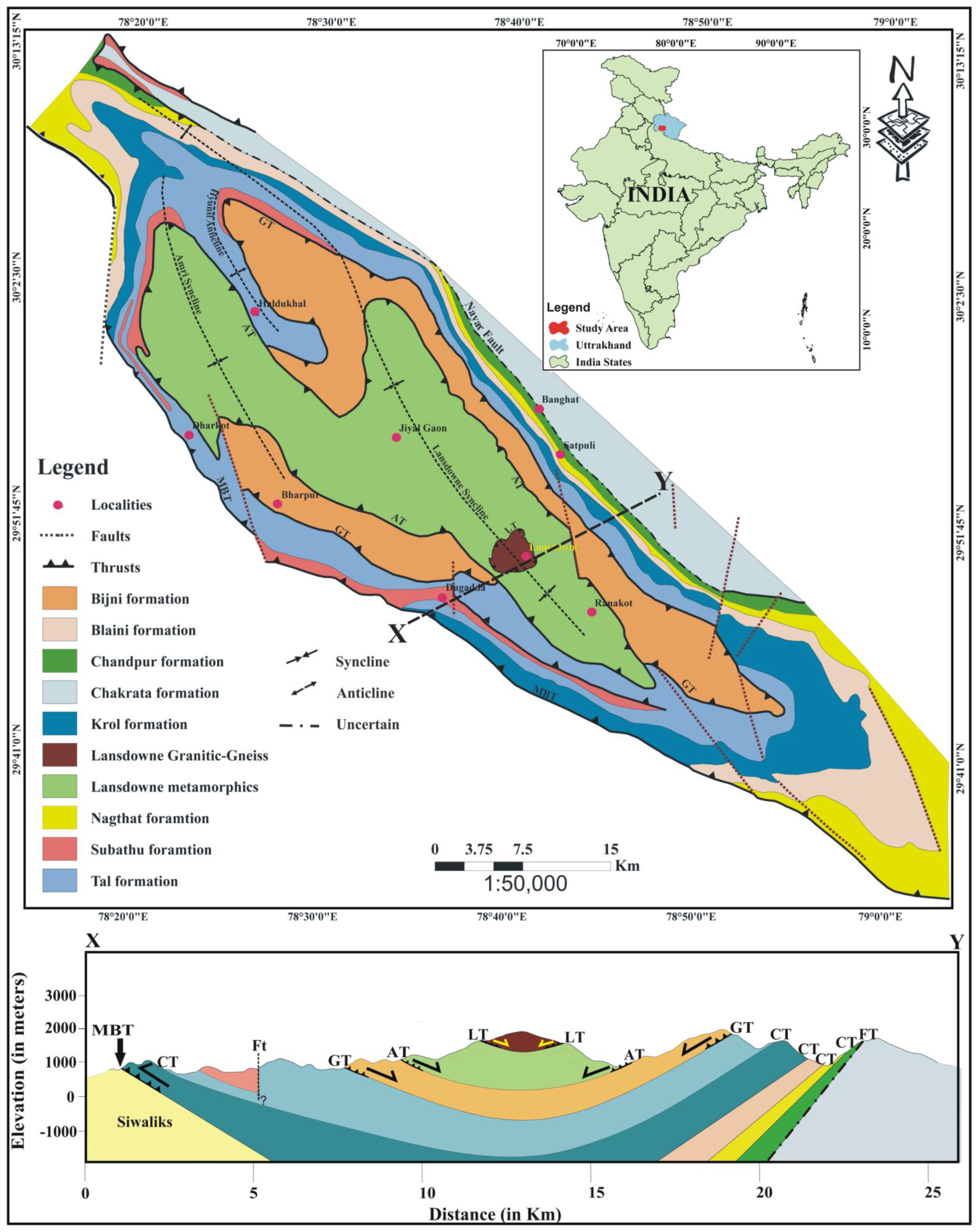
2. Geological Setting
3. Material and Methods
4. Results
4.1. Drainage Characteristics
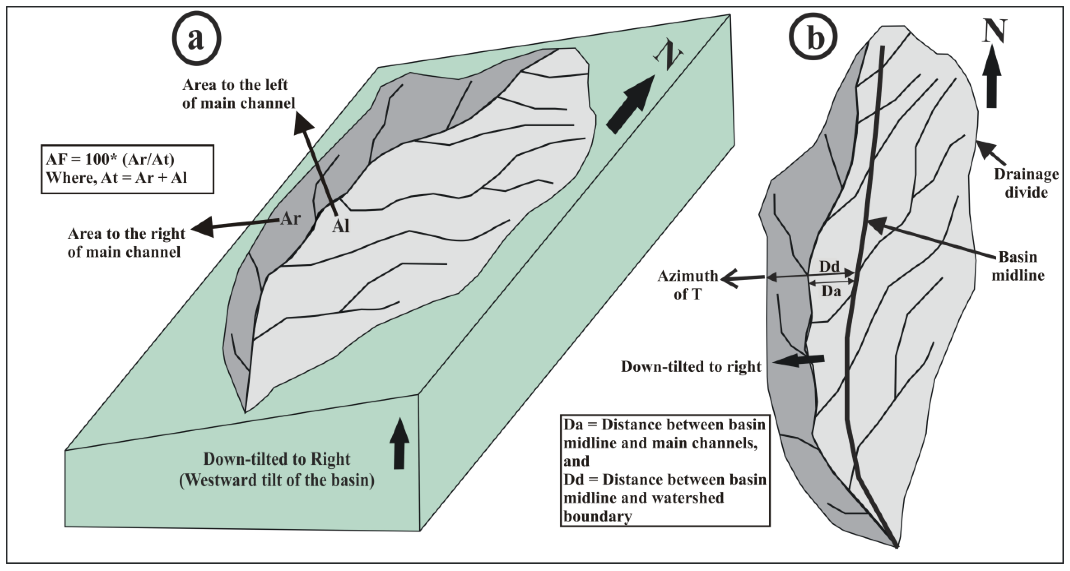
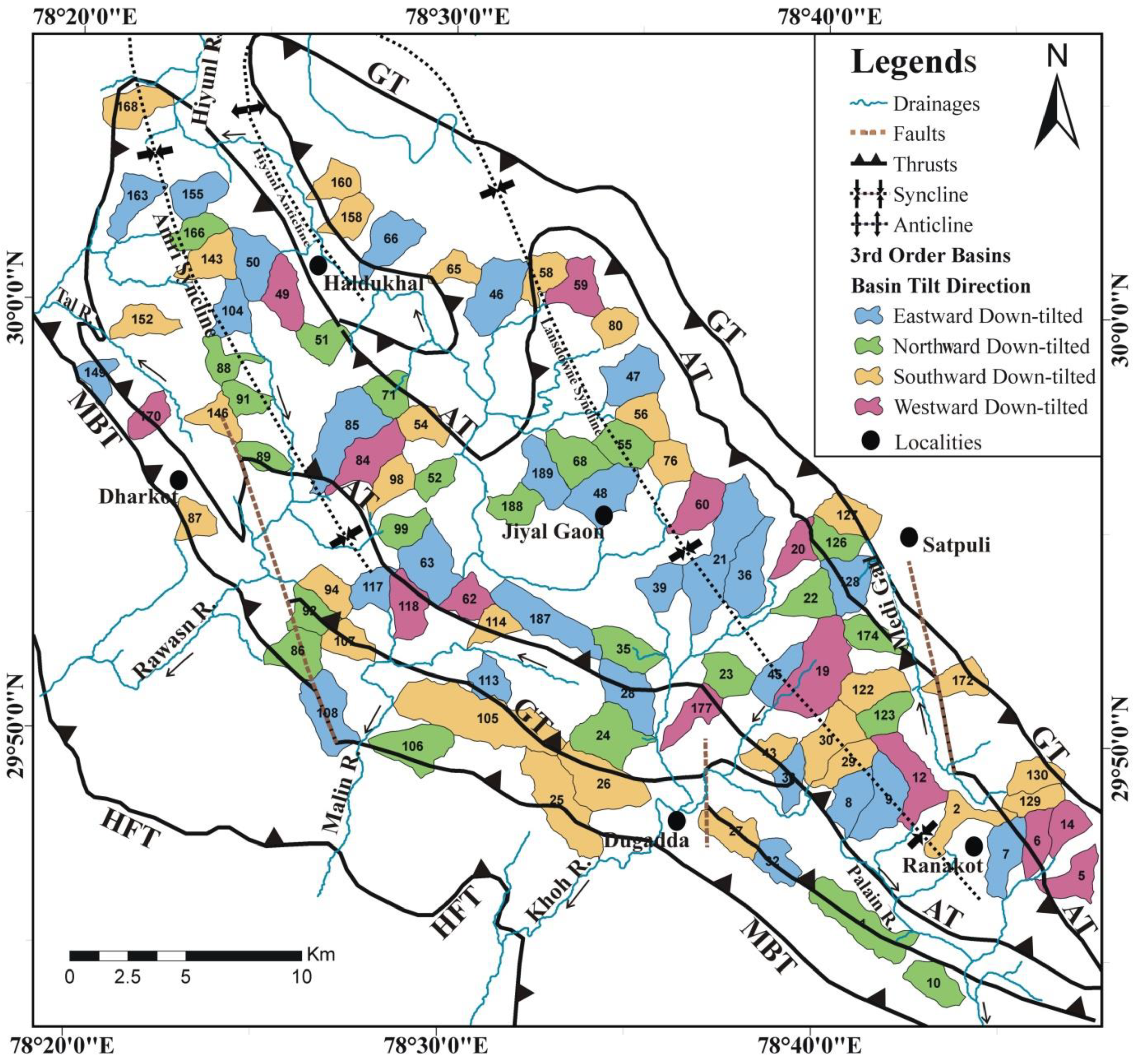
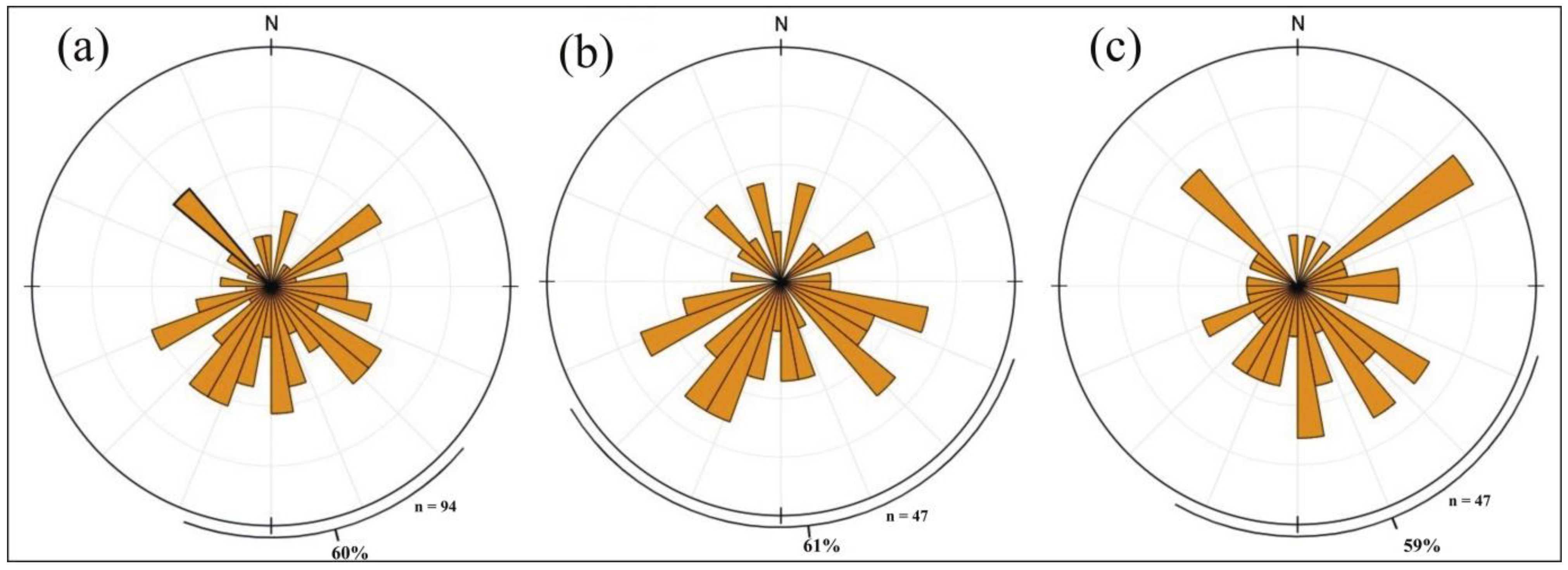
4.2. Geomorphic Indices
5. Discussion
6. Conclusions
- Regional and local thrusts govern the basin tilting. The variation in basin down-tilt indicates polyphase deformation and control of local faults in the basin development.
- The results after computing AF and T suggests tectonic blocks in the Garhwal synform are rapidly uplifting. The Main Boundary Thrust hanging wall is migrating towards the south due to the migration of the basin and its steep inclination.
- The quantitative and statistical analyses of T and AF infer that the tectonic movement in the region is unidirectional, i.e., towards the South.
- It is plausible that the hinge of the synform is experiencing compressional stresses, and the syncline is shrinking due to southward movement of the Garhwal synform tectonic block and northward movement of the Indian plate.
- The hydrological characteristics are affected by active tectonics, and basin tilting has resulted in lengthening drainages.
- The geomorphic indices used in this study are the requisite tools in ascertaining the role of active tectonics in crustal deformation.
- The study suggests that SRTM30 DEM used in this study is adequate to derive active tectonics by analyzing geomorphic indices in the lower elevations of the Himalayan terrain.
- The statistical analysis supports the null hypothesis of basin migration in both flanks of the river.
Author Contributions
Funding
Institutional Review Board Statement
Informed Consent Statement
Data Availability Statement
Acknowledgments
Conflicts of Interest
References
- Robinson, D.M.; Pearson, O.N. Was Himalayan normal faulting triggered by initiation of the Ramgarh–Munsiari thrust and development of the Lesser Himalayan duplex? Int. J. Earth Sci. 2013, 102, 1773–1790. [Google Scholar] [CrossRef]
- Thakur, V.C. Active tectonics of Himalayan Frontal Thrust and Seismic Hazard to Ganga Plain. Curr. Sci. 2004, 86, 1554–1560. [Google Scholar]
- Parkash, B.; Rathor, R.S.; Pati, P.; Jakhmola, R.P.; Singh, S. Convergence rates along the Himalayan Frontal Thrust inferred from terraces at Chandi devi Temple Hill, Haridwar, Northwestern Himalaya. Curr. Sci. 2011, 100, 1426–1432. [Google Scholar]
- Ponraj, M.; Miura, S.; Reddy, C.D.; Prajapati, S.K.; Amirtharaj, S.; Mahajan, S.H. Estimation of strain distribution using GPS measurements in the Kumaun region of Lesser Himalaya. J. Asian Earth Sci. 2010, 39, 658–667. [Google Scholar] [CrossRef]
- Cox, R.T.; Van Arsdale, R.B.; Harris, J.B. Identification of possible Quaternary deformation in the north-eastern Mississippi Embayment using quantitative geomorphic analysis of drainage-basin asymmetry. Geol. Soc. Am. Bull. 2001, 113, 615–624. [Google Scholar]
- Goswami, P.K.; Deopa, T. Quaternary block-tilting in southern Himalayan ranges of eastern Uttarakhand, India. Z. Geomorphol. 2012, 57, 45–60. [Google Scholar] [CrossRef]
- Ibanez, D.M.; Riccomini, C.; Miranda, F.P. Geomorphological evidence of recent tilting in the Central Amazonia Region. Geomorphology 2014, 214, 378–387. [Google Scholar] [CrossRef]
- Valdiya, K.S.; Narayana, A.C. River response to neotectonic activity: Example from Kerala, India. J. Geol. Soc. India 2007, 70, 427–443. [Google Scholar]
- Burbank, D.W.; Anderson, R.S. Tectonic Geomorphology, 2nd ed.; Wiley-Blackwell: Hoboken, NJ, USA, 2011; p. 454. [Google Scholar] [CrossRef]
- Keller, E.A.; Pinter, N. Active Tectonics: Earthquakes, Uplift, and Landscape, 2nd ed.; Prentice Hall: Upper Saddle River, NJ, USA, 2002. [Google Scholar]
- Azor, A.; Keller, E.A.; Yeats, R.S. Geomorphic indicators of active fold growth: South mountain-Oak Ridge anticline, Ventura basin, southern California. Geol. Soc. Am. Bull. 2002, 114, 745–753. [Google Scholar] [CrossRef]
- Kotlia, B.S.; Goswami, P.K.; Joshi, L.M.; Singh, A.K.; Sharma, A.K. Sedimentary environment and geomorphic development of the Uppermost Siwalik molasse in Kumaun Himalayan foreland basin, North India. Geol. J. 2018, 53, 159–177. [Google Scholar] [CrossRef]
- Goswami, P.K.; Pant, S. Active bidirectional tectonic-tilting in a part of the Almora Klippe, Kumaun Lesser Himalaya, India: Insights from statistical analyses of geomorphic indices. Quat. Int. 2019, 523, 46–53. [Google Scholar] [CrossRef]
- Hoolbrook, J.; Schumm, S.A. Geomorphic and sedimentary response of rivers to tectonic deformation: A brief review and critique of a tool for recognizing subtle epeirogenic deformation in modern and ancient settings. Tectonophy 1999, 305, 287–306. [Google Scholar] [CrossRef]
- Sreedevi, P.D.; Subrahmanyam, K.; Ahmed, S. Integrated approach for delineating potential zones to explore for groundwater in the Pageru River basin, Cuddapah District, Andhra Pradesh, India. Hyd. J. 2005, 13, 534–545. [Google Scholar] [CrossRef]
- Lahiri, S.K.; Sinha, R. Tectonic controls on themorphodynamics of the Brahmaputra River system in the upper Assam valley, India. Geomorphology 2012, 169–170, 74–85. [Google Scholar] [CrossRef]
- Rawat, A.; Bisht, M.P.S.; Sundriyal, Y.P.; Banerjee, S.; Singh, V. Assessment of soil erosion, flood risk and groundwater potential of Dhanari watershed using remote sensing and geographic information system, district Uttarkashi, Uttarakhand, India. Appl. Water Sci. 2021, 11, 119. [Google Scholar] [CrossRef]
- Jiang, G.; Christie-Blick, N.; Kaufman, A.; Banerjee, D.M.; Rai, V. Sequence Stratigraphy of the Neoproterozoic Infra Krol Formation and Krol Group, Lesser Himalaya, India. J. Sediment. Res. 2002, 72, 524–542. [Google Scholar] [CrossRef]
- Shanker, R.; Ganesan, T.M. A note on the Garhwal Nappe. Himal. Geol. 1973, 3, 241–258. [Google Scholar]
- Gupta, L.N. A Contribution to the Geology of the Lansdowne area, Garhwal Himalayas, India. J. Geol. Soc. Ind. 1976, 17, 449–460. [Google Scholar]
- Gupta, L.N. Abnormal tectonics of the allochthonous Lansdowne granite and the tectonic history of Garhwal nappe. Indian Miner. 1976, 17, 73–85. [Google Scholar]
- Sarkar, S.N.; Dutta, S.M. Structural Analysis of a Part of the Folded Garhwal Nappe Around Lansdowne, UP; Miscellaneous Publication-Geological Survey of India: Calcutta, India, 1982; Volume 41, pp. 241–258.
- Gairola, V.K. Structure and tectonics of Garhwal Synform. In The Himalayan Orogen and Global Tectonics; Oxford and IBH Publishing: New Delhi, India, 1992; pp. 89–104. [Google Scholar]
- Devrani, U.; Dubey, A.K. Anisotropy of magnetic susceptibility and petrofabric studies in the Garhwal synform, Outer Lesser Himalaya: Evidence of pop-up klippen. Island Arc 2008, 18, 428–443. [Google Scholar] [CrossRef]
- Valdiya, K.S. Geology of Kumaun Lesser Himalaya; Wadia Institute of Himalayan Geology: Dehradun, India, 1980. [Google Scholar]
- Valdiya, K.S. The Making of India: Geodynamic Evolution; Springer International Publishing: Cham, Switzerland, 2016. [Google Scholar]
- Gansser, A. Geology of the Himalayas; Interscience Publishers: London, UK, 1964. [Google Scholar]
- Banerjee, S.; Srivastava, H.B. Tectonic Implications of Small-Scale Structures in the Main Central Thrust Zone of Garhwal Higher Himalaya. In Structural Geometry of Mobile Belts of the Indian Subcontinent; Springer: Cham, Switzerland, 2020; pp. 213–232. [Google Scholar] [CrossRef]
- Fuchs, G.; Sinha, A.K. The tectonics of the Garhwal-Kumaun lesser Himalaya. Jahrb. Geol. Bundesanst. 1978, 121, 219–241. [Google Scholar]
- Valdiya, K.S. Geological Map of Kumaun Lesser Himalaya; Wadia Institute of Himalayan Geology: Dehradun, India, 2008. [Google Scholar]
- Middlemiss, C.S. Crystalline and metamorphic rocks of the Lower Himalaya, Garhwal and Kumaun. Rec. Geol. Surv. India 1887, 20, 134–143. [Google Scholar]
- Auden, J.B. Structure of the Himalaya in Garhwal. Rec. Geol. Surv. India 1937, 71, 407–433. [Google Scholar]
- Auden, J.B. Traverses in the Himalayas. Rec. Geol. Surv. India 1939, 69, 123–167. [Google Scholar]
- Heim, A.; Gansser, A. Central Himalaya-Geological observations of Swiss Expedition. Memoirés de la Société Helvétique des Sciences Naturelles 1939, 73, 1–245. [Google Scholar]
- Asthana, A.K.L. Landform evolution of the Nayar basin Garhwal Himalaya, Uttarakhand. Himalayan Geol. 2012, 33, 71–82. [Google Scholar]
- Maity, S.; Banerjee, S. Structural Architecture of Lansdowne Klippe in the Lansdowne Area: An Insight from Microstructural and AMS Studies. Master’s Thesis, Banaras Hindu University, Varanasi, India, 2018. [Google Scholar]
- Osborn, G.; du Toit, C. Lateral planation of rivers as a geomorphic agent. Geomorphology 1991, 4, 249–260. [Google Scholar] [CrossRef]
- Alexander, J.; Leeder, M.R. Geomorphology and surface tilting in an active extensional basin, SW Montana, USA. J. Geol. Soc. Lond. 1990, 147, 461–467. [Google Scholar] [CrossRef]
- Garrote, J.; Heydt, G.G.; Cox, R.T. Multi-stream order analyses in basin asymmetry: A tool to discriminate the influence of neotectonics in fluvial landscape development (Madrid Basin, Central Spain). Geomorphology 2008, 102, 130–144. [Google Scholar] [CrossRef]
- Perez-Pena, J.V.; Azor, A.; Azanon, J.M.; Keller, E.A. Active tectonics in the Sierra Nevada (Betic Cordillera, SE Spain): Insights from geomorphic indexes and drainage pattern analysis. Geomorphology 2010, 119, 74–87. [Google Scholar] [CrossRef]
- Agarwal, K.K.; Sharma, V.K. Quaternary tilt-block tectonics in parts of eastern Kumaun Himalaya, India. Z. Geomorphol. 2011, 55, 197–208. [Google Scholar] [CrossRef]
- Daxberger, H.; Riller, U. Analysis of geomorphic indices in the southern central Andes (23°–28° S): Evidence for pervasive quaternary to recent deformation in the puna plateau. Geomorphology 2015, 248, 57–76. [Google Scholar] [CrossRef]
- Gaidzik, K.; Ramirez-Herrera, M.T. Geomorphic indices and relative tectonic uplift in the Guerrero sector of the Mexican forearc. Geoscience Front. 2017, 8, 885–902. [Google Scholar] [CrossRef] [Green Version]
- Horton, R.E. Erosional development of streams and their drainage basins-hydrophysical approach to quantitative morphology. Geol. Soc. Am. Bull. 1945, 56, 275–370. [Google Scholar] [CrossRef] [Green Version]
- Hare, P.W.; Gardner, T.W. Geomorphic indicators of vertical neotectonism along converging plate margins, Nicoya Peninsula, Costa Rica. In Proceedings of the 15th Geomorphology Symposium; Allen and Unwin: Boston, MA, USA, September 1985; pp. 76–104. [Google Scholar]
- Keller, E.A.; Pinter, N. Active Tectonics, Earthquake Uplift and Landscape; Prentice Hall: Upper Saddle River, NJ, USA, 1996. [Google Scholar]
- Davis, J.C. Statistics and Data Analysis in Geology; John Wiley & Sons: Singapore, 2002; p. 639. [Google Scholar]
- Cox, R.T. Analysis of drainage-basin symmetry as a rapid technique to identify areas of possible Quaternary tilt-block tectonics: An example from the Mississippi Embayment. Geol. Soc. Am. Bull. 1994, 106, 571–581. [Google Scholar] [CrossRef]
- Sharma, G.; Ray, P.K.C.; Mohanty, S. Morphotectonic analysis and GNSS observations for assessment of relative tectonic activity in Alaknanda basin of Garhwal Himalaya, India. Geomorphology 2018, 301, 108–120. [Google Scholar] [CrossRef]
- Curray, J.R. The analysis of two-dimensional orientation data. J. Geol. 1956, 64, 117–131. [Google Scholar] [CrossRef]
- Ahmad, T.; Harris, N.; Bickle, M.; Chapman, H.; Bunbury, J.; Prince, C. Isotopic constraints on the structural relationships between the Lesser Himalayan Series and the High Himalayan Crystalline Series, Garhwal Himalaya. Geol. Soc. Am. Bull. 2000, 112, 467–477. [Google Scholar] [CrossRef]
- DeCelles, P.G.; Robinson, D.M.; Quade, J.; Ojha, T.P.; Garzione, C.N.; Copeland, P.; Upreti, B.N. Stratigraphy, structure, and tectonic evolution of the Himalayan fold-thrust belt in western Nepal. Tectonics 2001, 20, 487–509. [Google Scholar] [CrossRef]
- Jayangondaperumal, R.; Dubey, A.K. Superposed folding of a blind thrust and formation of klippen: Results of anisotropic magnetic susceptibility studies from the Lesser Himalaya. J. Asian Earth Sci. 2001, 19, 713–725. [Google Scholar] [CrossRef]
- Goswami, P.K.; Kshetrimayum, A.S. Pattern of active tectonic deformation across the Churachandpur-Mao thrust zone of Manipur Hills, Indo-Myanmar range, NE India: Inferences from geomorphic features and indices. Quat. Int. 2020, 553, 144–158. [Google Scholar] [CrossRef]
- Koukouvelas1, I.K.; Zygouri1, V.; Nikolakopoulos, K.; Verroios, S. Treatise on the tectonic geomorphology of active faults: The significance of using a universal global digital elevation model. J. Struct. Geol. 2018, 116, 241–252. [Google Scholar] [CrossRef]
- Mukul, M.; Mukul, M. Uncertainties in Digital Elevation Models from Global Advanced Land Observing Satellite (ALOS) digital topography data in the Indian subcontinent. J. Earth Syst. Sci. 2021, 130, 51. [Google Scholar] [CrossRef]


| Basin No. | AF | T | Zone | ||
|---|---|---|---|---|---|
| Value | Down-Tilt Direction | Mean Magnitude of T | Vector mean of T Azimuths | ||
| 1 | 67.949 | N | 0.97 | N37° | Southern Limb |
| 2 | 60.618 | S | 0.30 | N225° | |
| 5 | 20.334 | W | 0.89 | N256° | |
| 6 | 44.908 | W | 0.45 | N194° | |
| 7 | 59.585 | E | 0.56 | N137° | |
| 8 | 57.66 | E | 0.56 | N143° | |
| 9 | 62.4 | E | 0.83 | N108° | |
| 10 | 57.986 | N | 0.60 | N54° | |
| 12 | 44.572 | W | 0.88 | N249° | |
| 14 | 31.719 | W | 0.57 | N274° | |
| 19 | 26.165 | W | 0.92 | N312° | |
| 20 | 39.149 | W | 0.60 | N269° | |
| 21 | 53.664 | E | 0.59 | N145° | |
| 22 | 37.181 | N | 0.59 | N302° | |
| 23 | 48.525 | N | 0.63 | N72° | |
| 24 | 49.979 | N | 0.60 | N314° | |
| 25 | 30.634 | S | 0.93 | N233° | |
| 26 | 48.81 | S | 0.93 | N216° | |
| 27 | 55.872 | S | 0.59 | N167° | |
| 28 | 66.415 | E | 0.93 | N53° | |
| 29 | 64.978 | S | 0.62 | N183° | |
| 30 | 61.426 | S | 0.15 | N204° | |
| 32 | 34.64 | E | 0.68 | N94° | |
| 33 | 62.771 | E | 0.99 | N98° | |
| 35 | 65.468 | N | 0.96 | N89° | |
| 36 | 61.851 | E | 0.58 | N145° | |
| 39 | 43.749 | E | 0.97 | N175° | |
| 43 | 55.059 | S | 0.23 | N195° | |
| 45 | 70.353 | E | 0.97 | N125° | |
| 105 | 53.165 | S | 0.20 | N121° | |
| 106 | 29.166 | N | 1.00 | N353° | |
| 107 | 40.869 | S | 0.61 | N158° | |
| 108 | 68.726 | E | 0.86 | N57° | |
| 113 | 26.429 | E | 0.96 | N66° | |
| 114 | 61.126 | S | 0.60 | N177° | |
| 117 | 67.052 | E | 0.85 | N87° | |
| 118 | 39.39 | W | 0.64 | N243° | |
| 122 | 42.857 | S | 0.56 | N204° | |
| 123 | 50.344 | N | 0.59 | N296° | |
| 126 | 75.719 | N | 0.69 | N57° | |
| 127 | 45.66 | S | 0.29 | N172° | |
| 128 | 31.077 | E | 0.98 | N129° | |
| 129 | 56.987 | S | 0.60 | N132° | |
| 130 | 65.434 | S | 0.96 | N165° | |
| 172 | 64.438 | S | 0.57 | N212° | |
| 174 | 63.392 | N | 0.99 | N17° | |
| 177 | 30.17 | W | 0.98 | N316° | |
| 46 | 77.27 | E | 0.99 | N128° | Northern Limb |
| 47 | 61.68 | E | 0.97 | N130° | |
| 48 | 51.65 | E | 0.90 | N113° | |
| 49 | 51.15 | W | 0.98 | N258° | |
| 50 | 32.29 | E | 0.86 | N116° | |
| 51 | 53.04 | N | 0.61 | N304° | |
| 52 | 54.04 | N | 0.95 | N311° | |
| 54 | 31.82 | S | 0.64 | N225° | |
| 55 | 33.43 | N | 0.59 | N65° | |
| 56 | 62.88 | S | 0.96 | N197° | |
| 58 | 68.47 | S | 0.49 | N161° | |
| 59 | 43.09 | W | 0.45 | N244° | |
| 60 | 34.84 | W | 0.57 | N271° | |
| 62 | 56.07 | W | 0.98 | N256° | |
| 63 | 65.48 | E | 0.60 | N123° | |
| 65 | 70.30 | S | 0.62 | N210° | |
| 66 | 63.14 | E | 0.97 | N135° | |
| 68 | 39.57 | N | 0.71 | N64° | |
| 71 | 65.63 | N | 0.95 | N341° | |
| 76 | 51.17 | S | 0.23 | N180° | |
| 80 | 52.95 | S | 0.62 | N155° | |
| 84 | 36.13 | W | 0.28 | N244° | |
| 85 | 70.29 | E | 0.34 | N135° | |
| 86 | 29.24 | N | 0.99 | N351° | |
| 87 | 33.58 | S | 0.69 | N204° | |
| 88 | 68.04 | N | 0.68 | N55° | |
| 89 | 72.85 | N | 0.99 | N12° | |
| 91 | 66.49 | N | 0.99 | N12° | |
| 92 | 30.50 | N | 0.99 | N44° | |
| 94 | 65.67 | S | 0.95 | N201° | |
| 98 | 53.51 | S | 0.21 | N208° | |
| 99 | 57.19 | N | 0.60 | N312° | |
| 104 | 59.14 | E | 0.95 | N83° | |
| 143 | 63.19 | S | 0.90 | N170° | |
| 146 | 69.34 | S | 0.41 | N196° | |
| 149 | 33.28 | E | 0.95 | N102° | |
| 152 | 60.48 | S | 0.27 | N170° | |
| 155 | 49.76 | E | 0.49 | N212° | |
| 158 | 52.78 | S | 0.34 | N218° | |
| 160 | 51.24 | S | 0.19 | N228° | |
| 163 | 53.32 | E | 0.72 | N97° | |
| 166 | 38.18 | N | 0.95 | N340° | |
| 168 | 44.99 | S | 0.26 | N168° | |
| 170 | 61.45 | W | 0.33 | N240° | |
| 187 | 37.79 | E | 0.21 | N106° | |
| 188 | 38.74 | N | 0.73 | N326° | |
| 189 | 43.29 | E | 0.63 | N103° | |
Publisher’s Note: MDPI stays neutral with regard to jurisdictional claims in published maps and institutional affiliations. |
© 2021 by the authors. Licensee MDPI, Basel, Switzerland. This article is an open access article distributed under the terms and conditions of the Creative Commons Attribution (CC BY) license (https://creativecommons.org/licenses/by/4.0/).
Share and Cite
Rawat, A.; Banerjee, S.; Sundriyal, Y. Geomorphological and Statistical Assessment of Tilt-Block Tectonics in the Garhwal Synform: Implications for the Active Tectonics, Garhwal Lesser Himalaya, India. Geosciences 2021, 11, 345. https://doi.org/10.3390/geosciences11080345
Rawat A, Banerjee S, Sundriyal Y. Geomorphological and Statistical Assessment of Tilt-Block Tectonics in the Garhwal Synform: Implications for the Active Tectonics, Garhwal Lesser Himalaya, India. Geosciences. 2021; 11(8):345. https://doi.org/10.3390/geosciences11080345
Chicago/Turabian StyleRawat, Ashish, Sayandeep Banerjee, and Yaspal Sundriyal. 2021. "Geomorphological and Statistical Assessment of Tilt-Block Tectonics in the Garhwal Synform: Implications for the Active Tectonics, Garhwal Lesser Himalaya, India" Geosciences 11, no. 8: 345. https://doi.org/10.3390/geosciences11080345
APA StyleRawat, A., Banerjee, S., & Sundriyal, Y. (2021). Geomorphological and Statistical Assessment of Tilt-Block Tectonics in the Garhwal Synform: Implications for the Active Tectonics, Garhwal Lesser Himalaya, India. Geosciences, 11(8), 345. https://doi.org/10.3390/geosciences11080345


