Article

Brittle Deformation in the Neoproterozoic Basement of Southeast Brazil: Traces of Intraplate Cenozoic Tectonics

by
Marcos Roberto Pinheiro
1 and
Paola Cianfarra
2,*
1
Laboratory of Pedology, Department of Geography, Faculty of Philosophy, Languages and Human Sciences, University of São Paulo, São Paulo 05508-000, SP, Brazil
2
Dipartimento di Scienze della Terra, dell’Ambiente e della Vita, Università degli Studi di Genova, I-16132 Genova, Italy
*
Author to whom correspondence should be addressed.
Geosciences 2021, 11(7), 270; https://doi.org/10.3390/geosciences11070270
Submission received: 25 May 2021 / Revised: 24 June 2021 / Accepted: 24 June 2021 / Published: 27 June 2021
(This article belongs to the Special Issue Landscape Evolution in Tectonically Active Regions)

Abstract

:
The basement of southeast Brazil is traditionally interpreted as the result of Neoproterozoic and early Paleozoic orogenic cycles. Wide regions of the Atlantic Plateau (southeast Brazil) are characterized by rocks and tectonic structures of Precambrian age. According to the classical literature, these regions have not been affected by tectonics since the Miocene, despite the fact that they rest close to Cenozoic basins, which have suffered recent tectonic deformation. The objective of this research is to evaluate the role of neotectonics in the Atlantic Plateau. This task is accomplished through a multiscalar approach which includes lineament domain analysis from regionally sized digital elevation models and structural geology field surveys. Lineaments are automatically detected and statistically analyzed. Azimuthal analyses of data on faults and fractures by a polynomial Gaussian fit enables the identification of the main structural trends. Fault-slip direct inversion by means of the original Monte Carlo approach allows one to compute the multiple paleostresses that produced the measured fault population. The results show the presence of a principal ENE–WSW lineament domain, related to an old shear zone possibly reactivated since the Miocene. One of the paleostresses computed from fault-slip inversion is in agreement with the neotectonic stress-field proposed by other authors.

1. Introduction

The basement of the South American platform has been influenced by many orogenic cycles, such as the Transamazonian (2200–1900 Ma; Trouw et al. [1]), Uruaçuano (1750–1200 Ma; Brito Neves et al. [2]), and Brasiliano (800–500 Ma; Brito Neves et al. [3]). This last orogenic cycle particularly affected Brazilian territory, and gave rise to important E–W, ENE–WSW (Sadowski and Motidome [4]), and NE–SW ductile shear zones, forming deep strike-slip structures (Trouw et al. [1]) in south and southeast Brazil.
These structural trends influenced the geodynamics of western Gondwana, where the reactivation of inherited crustal weakness zones resulted from (i) the Paleozoic stages of Pangea amalgamation, and (ii) the following Mesozoic breakup, post-rift spreading, and drifting (Torsvik et al. [5]; Hasui [6]). The present-day geodynamic setting includes the ongoing South Atlantic opening, the clockwise rotation of South America, and the convergence between South America and Nazca plates (Lima et al. [7]). The presence of medium-to-low energy seismicity (moment magnitude up to 4.5; Bianchi et al. [8]) in intraplate setting of passive margin suggests the active role of (neo)tectonics.
Recent studies in southeast Brazil have emphasized onshore and offshore faults and shear zone reactivation, regional epirogenetic uplift, tectonic uplift, and basin evolution (Riccomini [9]; Riccomini et al. [10]; Almeida and Carneiro [11]; Tello Saenz et al. [12,13]; Zalán and Oliveira [14]; Hackspacher et al. [15,16]; Franco-Magalhaes et al. [17]; Cogné et al. [18,19]). Nevertheless, the role of neotectonics (e.g., the current tectonic regime active since the Miocene; Hasui [20]; Saadi [21]) is still a matter of debate.
The inherited tectonic structures exert control in the formation of the Continental Rift of southeast Brazil (CRSB) (Riccomini et al. [22]; Figure 1), an important tectono-stratigraphic segment, roughly parallel to the present-day coastline. This regional-scale tectonic feature includes a 900 km-long fault network which trends NE–SW/ENE–WSW and spatially develops from Curitiba city (Paraná State) to Barra de São João (Rio de Janeiro State). The CRSB developed due to the Paleogene normal reactivation of ancient NE–SW and ENE–WSW shear zones (Riccomini et al. [9]). This extensional setting provided conditions for the formation of Cenozoic tectonic basins, such as Taubate, Curitiba, and São Paulo sedimentary basins. The sedimentary deposits within these intraplate basins suffered deformations due to neotectonics (Riccomini et al. [9,10]; Salamuni et al. [23]).
Although the São Paulo basin is related to the CRSB, no evidence of neotectonic activity within this basin has been found to date. Freitas [24] inferred that this Cenozoic basin is a graben filled by sediments from the higher surrounding areas where crystalline rocks outcrop. Riccomini et al. [9,10,22] identified neotectonic activity in many parts of the RCSB, except in the São Paulo basin. Takiya [25] suggested probable tectonic activity in the São Paulo basin, although no neotectonic deformation has been identified in the field. Rodriguez [26] related the anomalies of the drainage pattern in the São Paulo sedimentary basin to recent tectonics (e.g., the entrenched meander of the Tietê river at Meandro do Morro de São João in Osasco city and the migration of the Pirajussara river), but the author did not provide field or drilling data to support this hypothesis.
The possible effects of neotectonics in the surrounding areas of the São Paulo Sedimentary Basin are uncertain or controversial. Ab’Saber [27,28] and Almeida [29] inferred the possibility of Cenozoic tectonic activity in the area without any field evidence. Rodriguez [26] suggests a possible influence of neotectonics on the folds within laterites which crop out in Pirapora do Bom Jesus city (metropolitan region of São Paulo city). On the other hand, Sígolo and Altafini [30] argue that such features are not related to tectonics.
Other areas present very little information regarding the effects of Cenozoic tectonics, such as the northwestern sector of the metropolitan region of São Paulo city. This area is close to the São Paulo Sedimentary Basin and comprises the Cantareira Ridge, Pico do Jaraguá Hill, and Perus regions (Figure 1). Ab’Saber [27,28] and Watanabe [31] studied the influence of tectonics on the landform development of this region, but they emphasized the role of the old tectonics. Carneiro et al. [32] and Henrique-Pinto and Assis Janasi [33] performed important structural analysis of the Pico do Jaraguá Hill and nearby zones, but focused on the ductile deformation, regarding Neoproterozoic to Paleozoic tectonics. On the other hand, Coutinho [34] and Cordani et al. [35] studied the ductile and brittle deformation of the Jaraguá region, concluding that the main fault trends (N45W and N25E) are coeval and related to pre-Cenozoic tectonics.
Despite the significant contributions provided by these studies, mostly concentrated on the old (Paleozoic and Proterozoic) tectonics, detailed information about the brittle deformation developed in the Cenozoic and at the upper crustal levels is sparse, and spatially concentrated in the small area of the Pico do Jaraguá region. Thus, this research aims to fill this gap and evaluate the characteristics of the brittle deformation that developed near the surface and in geologically recent times, not only in the Pico do Jaraguá zone, but also in other parts of the Atlantic Plateau. The results allow the provision of new constraints to better understand the possible neotectonics acting in this intraplate sector of Brazil.

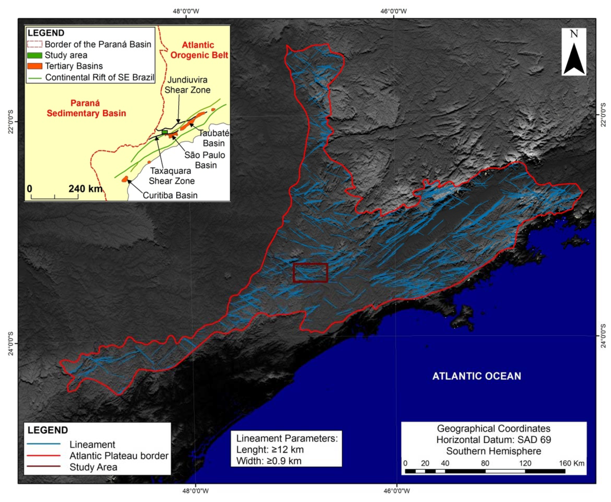
2. Geodynamic and Geological Settings of the Study Area

The study area is a sector of the Atlantic Plateau, in the northeastern zone of the metropolitan region of São Paulo city (southeast Brazil), in the Atlantic Orogenic Belt (Figure 1). This belt extends from Uruguay to the Espírito Santo State (Brazil), presenting a total length of around 2000 km (Machado et al. [36]). The geological setting of the area is the result of poly-phased tectonics and multiple reactivations of inherited crustal weakness zones formed during the supercontinent fragmentations and collisions that have been active since the Archean (Hasui [6]). The Brasiliano orogeny (800–500 Ma; Brito Neves et al. [3]) provided the crustal grain that controls the present-day structural setting of the region.
The Atlantic Orogenic Belt as a whole comprises long E–W and ENE–WSW structures (Sadowski and Motidome [4]), as well as NE–SW ductile shear (strike-slip) zones (Trouw et al. [1]). This belt comprises large terranes (i.e., Embu, the Costeiro and Pico do Papagaio complexes, Nappe Socorro-Guaxupé, and Votuverava), where São Roque and Serra de Itaberaba groups crop out together with granite intrusions. These also crop out in the study area (Figure 1).
The São Roque and Serra de Itaberaba groups are comprised of metamorphic rocks, such as phyllites, metasiltits, calcschists, marbles, dolomitic marbles, micaschists, metasandstones, amphibolites, metabasites, quartzites, migmatites, gneissic granites, and mylonites associated with regional-sized shear zones (Coutinho [37]; CPRM [38]). The granite intrusions (650 Ma; Assis Janasi and Ulbrich [39]) consist of syntectonic and post-tectonic batholiths, with fine to coarse phaneritic texture, light gray to dark gray and red (Hasui et al. [40]). According to these last authors, the composition ranges from tonalitic to granitic. Assis Janasi and Ulbrich [39] suggested a granodioritic to granitic composition. These intrusions are always bounded by fault zones (Gurgueira [41]).
In addition, there are local occurrences of clays, sands, and conglomerates related to the São Paulo and Caçapava formations (Cenozoic) covering low and smooth hills. Similar Quaternary deposits are found in the region, and are associated with the main streams, such as the Tietê and Juqueri rivers.
The study area is located between two tectonic structures ENE–WSW to NE–SW trending (Figure 1c): in the north, the Jundiuvira Fault; in the south, the Taxaquara Fault, which represents the tectonic contact between the crystalline rocks and the São Paulo sedimentary basin (Cenozoic). Both structures are associated with the Braziliano orogeny, but some of their sectors have been reactivated since the Miocene (Silva [42]; Peyerl et al. [43]).
Recent tectonic evidences were identified in other surrounding areas, as in the RCSB (Figure 1c; Riccomini et al. [9,10,22]), where four deformation events were recognized, and the last three are associated with neotectonics: (1) NNW–SSE extension, causing normal reactivation of old NE–SW/ENE–WSW strike-slip faults (Paleogene); (2) NE–SW compression and NW–SE extension, activating left-lateral strike-slips faults trending E–W (Neogene); (3) NW–SE compression, responsible for the right-lateral kinematics of structures that are E–W oriented (Upper Pleistocene to Holocene); and (4) E–W to WNW–ESE extension (Holocene). Fernandes and Amaral [44] also identified three Quaternary events in the transition between the Atlantic Orogeny Belt and the Paraná Basin, about 70 km north of the study area: (1) NW–SE compression and NE–SW extension; (2) N–S compression and E–W extension; and (3) NE–SW compression and NW–SE extension.
Coutinho [34] and Cordani et al. [35] studied the brittle deformation in our study area, and concluded that the main fault trends (N45W and N25E) are related to the pre-Cenozoic tectonics. Sígolo and Altafini (30) identified NNE–SSW faults and fractures cutting Quaternary laterites in the North of the study area (Pirapora do Bom Jesus city, Figure 1a). The kinematics and paleostresses responsible for these brittle deformations were not defined due to the intense weathering which obliterated any kinematic indicators.

3. Materials and Methods

The structural lineaments outcropping in part of southeast Brazil (specifically the Atlantic Plateau) were automatically detected and mapped in order to identify the main tectonic trends. According to Wise et al. [45], Cianfarra and Salvini [46,47], Lucianetti et al. [48], and Rossi et al. [49], lineaments cluster in azimuthal families called domains, which have a relationship with the upper crustal stress field. In the present study, the lineaments were identified on the Digital Elevation Model (DEM) of the Shuttle Radar Topography Mission (SRTM) data, whose spatial resolution is 30 m (1 arcsecond) in the investigated area.
Four shadow images were generated according to multiple lighting conditions (0°, 45°, 90°, and 135°) with sun elevation of 20°. This allowed us to overcome limits related to the single lighting condition, which tends to rotate or even suppress alignment nearly parallel to the direction of illumination (e.g., Wise [50]). The SRTM DEM was processed with Envi™ 4.7 software, following the methodology proposed by Cianfarra and Salvini [51]. Specifically, we applied (i) low pass convolution filters in order to remove small morphological variations related to negligible, local-scale factors, and (ii) Laplacian filters to enhance the aligned tonal patterns related to tectonics. The processed images were then analyzed with SID 3 software (Slope-Intercept Density Analysis, Salvini [52]), for the automatic detection of lineaments. The software looks for all possible alignments of pixel within the analyzed raster image according to certain parameters, e.g., lineament minimum length, lineament width, and pixel density along the lineament. In this study, the parameters have been tuned to look for lineaments longer than 12,000 m and with an average width of 900 m.
The automatically detected lineaments were cumulated into a database and statistically analyzed by azimuthal frequency diagrams (Cianfarra and Salvini [51]). The polymodal Gaussian fit was performed with Daisy3 software (freely available at http://host.uniroma3.it/progetti/fralab, accessed on January 2021). This analysis allows one to identify the main azimuthal trends which correspond to the lineament domains.
Structural field measurements included faults with their kinematic indicators, fracture cleavage planes (i.e., Riedel planes), joints, veins, folds, and metamorphic foliation. These data are stored in a georeferenced database for statistical analyses with Daisy3 software. Structural data are projected on a Schmidt Net (lower hemisphere) to explore their azimuthal distribution. Fault kinematics were determined either from the kinematic indicators on the fault plane (such as fibers, abrasion tracks, and mineral lineation) or by computing the intersection of faults with their associated Riedel planes. Thus, it is possible to derive the faults’ kinematic vector and their rotax (slip normal or rotational axis, Wise and Vincent [53]). The rotax is a vector that approximates the σ2 orientation in faults that were generated by stress fields exceeding the rock strength according to the Coulomb Failure Criterion (e.g., Fossen [54]).
The paleostress orientations are computed by fault-slip inversions, following the original Monte Carlo Direct inversion tool (implemented in the free Daisy3 software), which allows the computation of one or multiple paleostresses that produced the measured fault population. This inversion method routinely generates random stress tensor(s) and successively compares each fault with computed paleostress(es). The average angular deviation between the pitch of the kinematic vector measured on the fault plane, and the predicted one by applying the computed paleostress tensor(s), provides the MAD (Mean Angular Deviation) error. The best orientation of the principal paleostress(es) is achieved by a convergent methodology (e.g., Tarantola [55]) that consists of evaluating the reliability of the solution through the MAD. At each point, the MAD is compared with the lowest value that was previously found. If it is lower, the new paleostress is memorized as the (temporary) best fit. The comparison is repeated for a number of cycles of pre-determined attempts (10,000 in our analysis) until no better solution is found within the cycle. The range of interval of randomly generated factors is reduced at each new cycle, thus progressively improving the Monte Carlo best fit. In this way, the final result represents the best stress condition to explain the analyzed fault population. The reliability of the fit is quantified by the MAD. In the cumulated analysis of fault data collected in a wide region, a MAD value lower than 40° is considered reliable.
Given that the focus of our analysis is to explore the regional stress field (as compared to regionally sized structural trends/lineaments), the data were analyzed together instead of by individual analysis by single outcrop, whose data can be influenced by local factors.
The multiscalar approach used in this study includes a comparison of the results from the analysis of field structural data and lineament detected from regional scaled images. This supports the investigation into the possible tectonic scenarios responsible for the formation or reactivation of the studied tectonic structures.

4. Results: Data Analyses

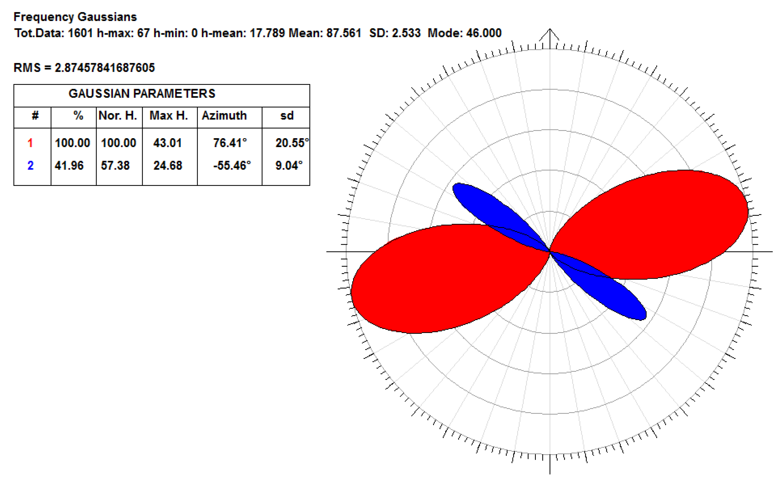
4.1. Lineament Domain Analysis

A total of 1601 lineaments were automatically detected in the Atlantic Plateau region (see Figure 2). The polymodal Gaussian fit of their azimuthal frequency diagram shows the existence of a main lineament domain which is ENE–WSW trending (N76° E with a standard deviation sd = 21°, Figure 3). A minor, sub-order lineament domain trending NW–SE (N55° W, sd = 9°) was also detected in the study region. Following the classical and current literature on lineament domains (e.g., Wise et al. [45]; Cianfarra and Salvini [46,47]; Lucianetti et al. [48]; and Rossi et al. [49]), and according to the geodynamic meaning of lineament domains, the maximum horizontal stress component (Shmax) and the minimum horizontal stress component (Shmin) in the upper/brittle crust are, respectively, parallel and perpendicular to the principal lineament domain. Thus, the performed lineament domain analysis suggests that the Shmax in the study region is ENE–WSW trending, and the Shmin is NNW–SSE oriented.

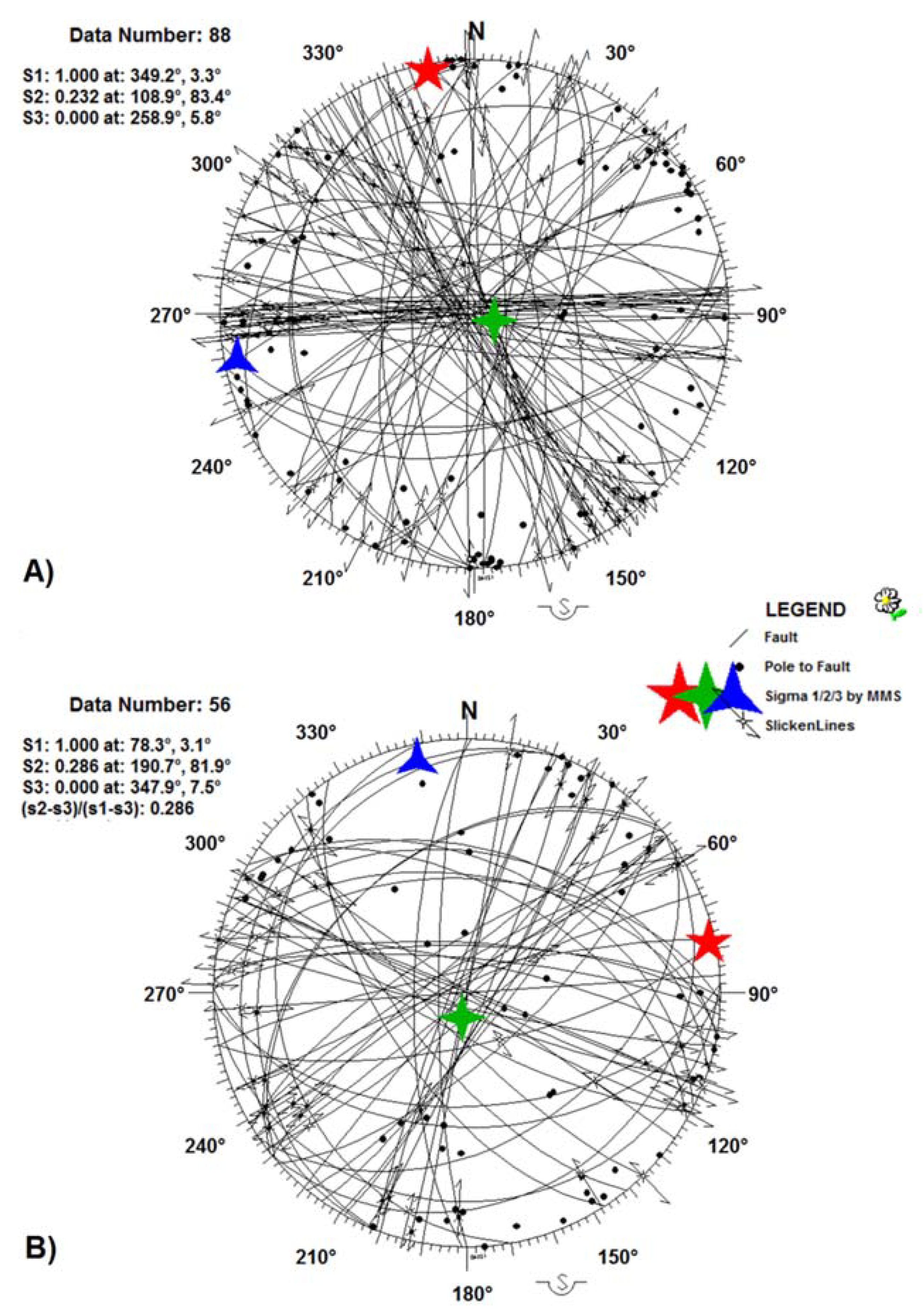
4.2. Field Structural Data
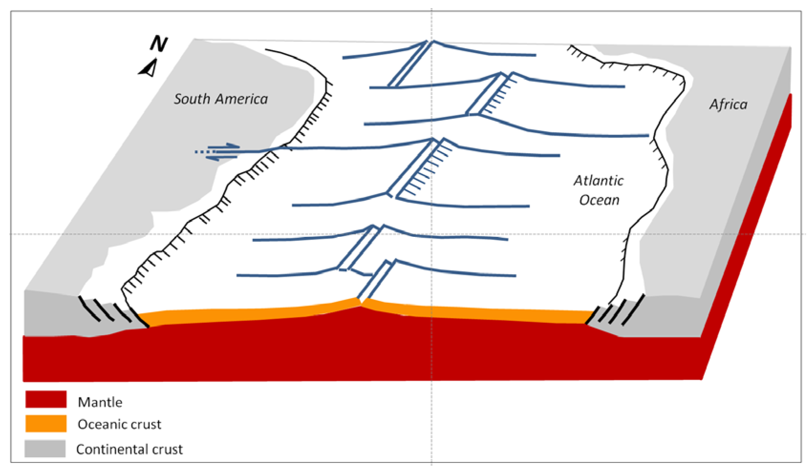
A total of 1233 structural data were surveyed at 110 outcrops in the study area (their location can be seen in Figure 1a).
Strike-slip faults are dominant in the study area, whereas normal and reverse structures are less frequent, and generally related to transtensive and transpressive regimes (Figure 4a), respectively. The strike-slip faults are sub-vertical to vertical (Dip > 80°), and present clear kinematic indicators (fibers, striaes, and steps), fracture cleavage planes (i.e., Riedel planes fracture R of the Riedel Shear model), and sometimes gouges, cataclasites (Figure 4b), and fault breccias. Some faults present traces of more than one tectonic event, such as the structures described in Morro do Tico Tico Hill (Figure 1), which present sub-horizontal (younger) and down dip (older) slickenlines. Regarding the low angle faults, they are predominantly normal, but sometimes present strike-slip components (Figure 4c). In Morro do Tico Tico Hill, as well as in Pico do Jaraguá Hill, these faults could be the oldest structures, considering how they are offset by strike-slip faults on many occasions (Figure 4d,e).
Measured faults are nearly vertical, as suggested by the sub-horizontal clustering of the poles-to-fault planes (Figure 5A), where the mean azimuthal trend is ENE–WSW (two main poles-to-fault plane clusters are NNW–SSE and NE–SW trending). The fault slicks are horizontal to sub-horizontal (Figure 5B), and the fault rotaxes show a strong vertical clustering (Figure 5C). This confirms the main strike-slip character of the measured faults.
Fault-slip inversion by the Multiple Monte Carlo Direct Solution provides two reliable paleostresses (MAD < 40°, Figure 6) characterized by a vertical σ2 compatible with a strike-slip tectonic setting. The solution presented in Figure 6A describes a paleostress characterized by sub-horizontal σ1 and σ3 oriented N349° (or N11° W) and N259° (or N79° E), respectively. This is compatible with a right-lateral sense of shear along an E–W regional shear corridor (whose existence has been suggested by previous authors, e.g., Zalán et al. [56], Saadi [21], Morales [57], and Pinheiro et al. [58]). As the angle between the regional shear corridor and the computed σ1 is bigger than 45° (specifically, 79°), a transpressional component of 61% exists along the regional E–W corridor of deformation (e.g., Rossi et al. [49]). The second paleostress solution (Figure 6B) is characterized by a switch of the two sub-horizontal minimum and maximum stresses being σ3 oriented N348° (or N12° W) and σ1 oriented N78° (or N78° E). These tensors are compatible with a left-lateral kinematics along the possible E–W regional shear corridor. The angle of 12° between the computed σ1 and the shear corridor (i.e., smaller than 45° for the pure strike-slip setting) suggests a transtensional component of 61% (e.g., Rossi et al. [49]).
The rare field data surveyed only in Cenozoic materials, whose deformation is more probably related to neotectonics, indicate the predominance of vertical fractures (Figure 7A,B) N–S trending, with minor rotation to NNE–SSW and NNW–SSE. These structures are decametric spaced, filled by iron hydroxides, and particularly disturb laterites (Figure 7C) linked to São Paulo Basin Cenozoic deposits (Sígolo and Altafini [30]). Their kinematic indicators are inconspicuous, but a synthetic cleavage, about 15° from the main fracture, suggests a possible shear with a right-lateral sense of movement of the N–S and NNE–SSW fractures family set. The NNW–SSE fractures affect Quaternary deposits of the Juqueri River fluvial terrace (Figure 7D) and would have left-lateral kinematics.

5. Discussion

The trends identified by means of the lineament domain analysis correspond to the most common orientations of the tectonic features in southeast Brazil. The ENE–WSW trend is frequently associated with the Neoproterozoic Brasiliano orogeny (Sadowski and Motidome [4]) that affected the Precambrian basement, which comprises the Atlantic Plateau, where the study area is located. Thus, these lineament domains could be related to very old tectonics. On the other hand, according to Wise and McCrory [59], the lineament domain may reflect the recent tectonics or reactivation of ancient crustal weakness zones. Thus, some of these structures of southeast Brazil may also be related to Cenozoic tectonics, as suggested by Hiruma et al. [60], Riccomini et al. [10,22], Salamuni et al. [23], Negrão [61], Brêda et al. [62], and Giro et al. [63].
However, the existence of a regional shear corridor, E–W trending in southeast Brazil, has been proposed by several authors (Zalán et al. [56], Saadi [21], Morales [57], and Pinheiro et al. [58]). The evidence of brittle deformation measured in the field frame well within this regional deformation corridor, and its left-lateral movements with a transtensional component is in agreement with the paleostress shown in Figure 6B. This kinematics is not compatible with the neotectonic setting (the current tectonic regime acting since the Miocene, e.g., Hasui [20], Saadi [21]) in southeast Brazil, considering the typical stress-field of this region inferred by important studies (Riccomini [64], Facincani [65], Hasui et al. [66], Morales [57], Pinheiro et al. [58]). Riccomini [64] and Facincani [65] considered the existence of long E–W structures which have presented right-lateral movements since the Miocene on the northeast border of the Paraná Basin. Hasui et al. [66] and Morales [57] considered that the morphotectonic domains of southeast and south Brazil are being influenced by extensional, compressive, and transtension–transpression processes related to right-lateral movements along an E–W shear zone, as a consequence of the rotation of the South American plate. Pinheiro et al. [58] supposed a right-lateral neotectonic activity of a E–W shear corridor in the northeast border of the Paraná Basin. A similar setting was proposed by Francheteau and Le Pichon [67]. The E-W deformation corridor proposed by Pinheiro et al. [58] was considered as the continental continuation of off-shore fractures zones, similar to Vasconcelos et al.’s [68] inferences in relation to northeast Brazil, and the probable action of oceanic crust structures (Vitória-Trindade Fracture Zone) in the South American continent, as supposed by Barão et al. [69]. Thus, the left-lateral movements of the regional E–W shear zone may have been active prior to the Miocene (Figure 8).
The structures surveyed in the field are almost restricted to Precambrian rocks and present characteristics (e.g., mineral filling), which suggests that these fractures are also older than the Miocene, or have not been recently reactivated. The data surveyed only in younger rocks, whose deformation is more probably related to neotectonics, are rare (see Figure 7). Further studies are necessary to clarify whether recent tectonics has only reactivated smaller structures, as suggested by Giro et al. [63].
Regarding the paleostresses, the Shmax (N76° E) and Shmin (N14° W) inferred from the regional lineament analysis (the orientation of the main lineament domain; see Figure 2 and Figure 3) is very close to the orientation of the maximum horizontal compression, σ1—N78° E (and minimum horizontal stress, σ3—N12° W), inferred through the Multiple Monte Carlo approach shown in Figure 6B. Such close parallelism indicates that the obtained solution is robust and reliable, as different datasets converged to the same paleostress. Thus, lineaments and the brittle deformation measured in the field are the result of the same causes/driving mechanism, that is, the tectonic stress.
The paleostress described in Figure 6A, whose Shmax and Shmin are N11° W and N79° E oriented, respectively, is compatible with the right-lateral kinematics of the E–W shear zone with a transpressional component. In addition, it is similar to the neotectonic stress-field (Shmax: NW–SE; Shmin: NE–SW) inferred from other authors (e.g., Hiruma et al. [60]; Riccomini et al. [10,22]; Fernandes and Amaral [44]; Santos and Ladeira [70]; Silva and Mello [71]; Pinheiro and Queiroz Neto [72]; Pinheiro et al. [58]; Giro et al. [63]; Brêda et al. [62]; and Silva et al. [73]) for many sectors of south and southeast Brazil. This suggests that the computed stress may reasonably relate to Cenozoic tectonics, and possibly to neotectonics.
In summary, the main lineament domain (ENE–WSW), as well as most of the faults (ENE–WSW) identified in the outcrops, are related to pre-Miocene tectonics (Gondwana breakup?), whose stress-field (Shmax: ENE–WSW; Shmin: NNW–SSE) induced a left-lateral strike-slip with transtension along the regional E–W shear corridor in southeast Brazil. The subsequent change in the geodynamic setting with the opening of the South Atlantic (about 110 Ma) and the drifting of the South American Plate (Miocene–Quaternary) was responsible for a new stress-field, as inferred by Hasui [20] and Saadi [21]. This new stress-field is responsible for the right-lateral strike-slip with a transpressional component along the regional E–W shear corridor (Figure 9), and for the reactivation of smaller structures, as the fractures offsetting Quaternary materials (see Figure 7). At the same latitude, and along the same direction, exists an offshore regional tectonic alignment, namely the Rio de Janeiro Fracture Zone, which rules the recent evolution of this sector of the South Atlantic (Bird and Stuart [74]) and shapes the morphology of the sea bottom. We propose that this fracture zone may represent the ocean ward continuation of the E–W trending shear zone cutting through southeast Brazil. Moreover, both the Brazilian coastline and the continental–ocean boundary present a dextral offset at the latitude of our study region (22°–23° S). Zalán et al. [56], Saadi [21], and Alves et al. [75] proposed a similar setting based on (i) the near parallelism between the tectonic structures in the continent and the offshore tectonic alignments, and (ii) the mapping of earthquake epicenters. Similar connections between continental and oceanic tectonic structures have been described in other regions (e.g., between Australia and Antarctica, Zanutta et al. [76,77], Lesti et al. [78], and Salvini et al. [79])

6. Conclusions

The Atlantic Plateau in southeast Brazil is characterized by brittle deformation related to post-Brasiliano orogeny (500–850 Ma) tectonics. The discovered ENE–WSW lineament domain may relate to the pre-Miocene tectonic reactivation of the Brasiliano structures. This lineament domain frames within an E–W shear zone, which has affected southeast Brazil. Such a regionally sized corridor of deformation may represent the continental continuation of the offshore Rio de Janeiro fracture zone in the Atlantic Ocean.
The structures surveyed in the outcrops indicate the predominance of strike-slip faults with a mean azimuthal trend ENE–WSW. Such faults present both sinistral and dextral movements, sometimes with oblique movements, and are compatible with the existence of the regional E–W shear corridor. One of the paleostresses calculated (NNW–SSE compression and ENE–WSW extension) is fully compatible with the neotectonic stress inferred by other studies (e.g., Hiruma et al. [60]; Riccomini et al. [10,22]; Fernandes and Amaral [44]; Santos and Ladeira [69]; Silva and Mello [70]; Pinheiro and Queiroz Neto [71]; Pinheiro et al. [58]; Giro et al. [63]; Brêda et al. [62]; and Silva et al. [73]) and with the more recent right-lateral kinematics with transpressional component along the E–W shear zone. In addition, some of the measured faults offset Quaternary deposits.
The moderate seismicity present in the intraplate setting along the passive margin of the South American plate strongly suggests the important role of neotectonics. In the study area, the maximum horizontal stress component (Shmax) derived from focal mechanisms, faults, and in situ measurements shows a NE–SW orientation. This is in line with our findings from the lineament domain analyses and fault-slip inversions.
This situation suggests Cenozoic tectonics acting in the Atlantic Plateau, but further studies and field data are still required to explore the possible effects of tectonics on the landforms and the landscape evolution as a whole.

Author Contributions

Conceptualization, M.R.P.; methodology, M.R.P. and P.C.; software, M.R.P. and P.C.; validation, M.R.P. and P.C.; formal analysis, M.R.P. and P.C.; investigation, M.R.P. and P.C.; resources, M.R.P.; data curation, M.R.P.; writing—original draft preparation, M.R.P. and P.C.; writing—review and editing, M.R.P. and P.C.; visualization, M.R.P. and P.C.; supervision, M.R.P. and P.C.; project administration, M.R.P.; and funding acquisition, M.R.P. and P.C. All authors have read and agreed to the published version of the manuscript.

Funding

Part of this research (publication fee) was financially supported by the University of Genova funding to Paola Cianfarra (FRA, Fondi per Ricerca di Ateneo, grant 100022-2020-FRA2019-Cianfarra). Paola Cianfarra fieldwork was financially supported by GeoQuTe Lab (responsible F. Salvini).

Data Availability Statement

Not applicable.

Acknowledgments

We thank the anonymous reviewers for their thorough reviews that improved the paper. In addition, we thank the Nostradamos Research Group (Laboratory of Pedology, Department of Geography, University of São Paulo, Brazil), especially André Mateus Barreiros and Andrio Filipe Amaral Soares, for the support during field surveys, and Francesco Salvini (Roma Tre University, Italy) for providing the implemented version of the Daisy3 software with Multiple Monte Carlo Fault inversion tool as well as the SID software for automatic lineament detection. Paola Cianfarra dedicates this work to the loving memory of Maria Rosa D’Amico.

Conflicts of Interest

The authors declare no conflict of interest.

References

  1. Trouw, R.A.J.; Heilbron, M.; Ribeiro, A.; Paciullo, F.; Valeriano, C.M.; Almeida, J.C.H.; Schobbenhaus, C.; Bellizzia, A. Geologic Map of South America; Ministry of Mines and Energy: Brasilia, Brazil, 2000.
  2. Brito Neves, B.B.D.; Teixeira, W.; Tassinari, C.C.G.; Kawashita, K. A contribution to the sudivision of the Precambrian in South America. Rev. Bras. Geociências 1990, 20, 267–276. [Google Scholar] [CrossRef]
  3. Neves, B.B.D.B.; Fuck, R.A.; Pimentel, M.M. The Brasiliano collage in South America: A review. Braz. J. Geol. 2014, 44, 493–518. [Google Scholar] [CrossRef]
  4. Sadowski, G.R.; Motidome, M.J. Brazillan Megafaults. Andean Geol. 1987, 31, 61–75. [Google Scholar]
  5. Torsvik, T.H.; Rousse, S.; Labails, C.; Smethurst, M.A. A new scheme for the opening of the South Atlantic Ocean and the dissection of an Aptian salt basin. Geophys. J. Int. 2009, 177, 1315–1333. [Google Scholar] [CrossRef] [Green Version]
  6. Hasui, Y. A grande colisão pré-cambriana do sudeste brasileiro e a estruturação regional. Geociências 2010, 141–169. [Google Scholar]
  7. Lima, C.; Nascimento, E.; Assumpção, M. Stress orientations in Brazilian sedimentary basins from breakout anaysis: Implications for force models in the South American Plate. Geophys. J. Int. 1997, 130, 112–124. [Google Scholar] [CrossRef] [Green Version]
  8. Bianchi, M.B.; Assumpção, M.; Rocha, M.P.; Carvalho, J.M.; Azevedo, P.A.; Fontes, S.L.; Costa, I.S. The Bra-zilian seismographic network (RSBR): Improving seismic monitoring in Brazil. Seismol. Res. Lett. 2018, 89, 452–457. [Google Scholar] [CrossRef]
  9. Riccomini, C. O Rift Continental do Sudeste do Brasil. Unpublished Ph.D. Thesis, Institute of Geosciences of the University of São Paulo, São Paulo, Brazil, 1989. [Google Scholar]
  10. Riccomini, C.; Sant’Anna, L.G.; Ferrari, A.L. Evolução Geológica do Rift Continental do Sudeste do Brasil. In Geologia do Continente Sul-Americano: Evolução da Obra de Fernando Flávio Marques de Almeida; Beca Produções Culturais: São Paulo, Brazil, 2004; pp. 383–405. [Google Scholar]
  11. Almeida, F.F.M.; Carneiro, C.D.R. Origem e evolução da Serra do Mar. Rev. Bras. De Geociências 1998, 28, 135–150. [Google Scholar] [CrossRef]
  12. Tello Saenz, C.A.; Hackspacher, P.C.; Hadler Neto, J.C.; Iunes, P.J.; Guedes, S.; Paulo, S.R.; Ribeiro, L.F.B. Recognition of creta-ceous, paleocene and neogene tectonic reactivation, through apatite fis¬sion-track analysis, in Precambrian areas of the Southeast Brazil: Association with the South Atlantic Ocean opening. J. S. Am. Earth Sci. 2003, 15, 137–142. [Google Scholar] [CrossRef]
  13. Tello Saenz, C.A.; Hadler Neto, J.C.; Iunes, P.J.; Guedes, S.; Hackspacher, P.C.; Ribeiro, L.F.B.; Paulo, S.R.; Osório, A.M.A. Thermo-chronology of the South American Platform in the state of São Paulo, Brazil, through apatite fission tracks. Radiat Meas 2005, 39, 635–640. [Google Scholar] [CrossRef]
  14. Zalán, P.V.; Oliveira, J.A.B. Origem e evolução estrutural do Sis¬tema de Riftes Cenozóicos do Sudeste do Brasil. Bol. Geociências Petrobrás 2005, 13, 269–300. [Google Scholar]
  15. Hackspacher, P.C.; Ribeiro, L.F.B.; Ribeiro, M.C.S.; Fetter, A.H.; Hadler Neto, J.C.; Tello Saenz, C.A.; Dantas, E.L. Con-solidation and break-up of the South American platform in Southeastern Brazil: Tectonothermal and denudation histories. Gondwana Res. 2004, 7, 91–101. [Google Scholar] [CrossRef]
  16. Hackspacher, P.C.; De Godoy, D.F.; Ribeiro, L.F.B.; Neto, J.C.H.; Franco, A.O.B. Modelagem térmica e geomorfologia da borda sul do Cráton do São Francisco: Termocronologia por traços de fissão em apatita. Rev. Bras. Geociências 2007, 37, 76–86. [Google Scholar] [CrossRef]
  17. Franco-Magalhaes, A.O.B.; Hackspacher, P.C.; Glasmacher, U.A.; Saad, A.R. Rift to post-rift evolution of a “passive” continental margin: The Ponta Grossa Arch, SE Brazil. Int. J. Earth Sci. 2010, 99, 1599–1613. [Google Scholar] [CrossRef]
  18. Cogné, N.; Gallagher, K.; Cobbold, P.R. Post-rift reactivation of the onshore margin of southeast Brazil: Evidence from apatite (U–Th)/He and fission-track data. Earth Planet. Sci. Lett. 2011, 309, 118–130. [Google Scholar] [CrossRef]
  19. Cogné, N.; Gallagher, K.; Cobbold, P.R.; Riccomini, C.; Gautheron, C. Post-breakup tectonics in southeast Brazil from thermochronological data and combined inverse-forward thermal history modeling. J. Geophys. Res. Space Phys. 2012, 117, 2-009340. [Google Scholar] [CrossRef] [Green Version]
  20. Hasui, Y. Neotectônica e Aspectos Fundamentais da Tectônica Ressurgente no Brazil. In 1o. Workshop Sobre Neotectônica e Sedimentação Cenozóica Continental no Sudeste Brasileiro, Belo Horizonte; Boletim no. 11; Sociedade Brasileira de Geologia: São Paulo, Brazil, 1990; pp. 1–31. [Google Scholar]
  21. Saadi, A. Neotectônica da Plataforma Brasileira: Esboço e interpretação preliminares. Rev. Geonomos 1993, 1, 1–15. [Google Scholar] [CrossRef]
  22. Riccomini, C.; Peloggia, A.; Saloni, J.; Kohnke, M.; Figueira, R. Neotectonic activity in the Serra do Mar rift system (southeastern Brazil). J. S. Am. Earth Sci. 1989, 2, 191–197. [Google Scholar] [CrossRef]
  23. Salamuni, E.; Ebert, H.D.; Hasui, Y. Morfotectônica da bacia sedimentar de curitiba. Rev. Bras. De Geociências 2004, 34, 469–478. [Google Scholar] [CrossRef] [Green Version]
  24. Freitas, R.O. Sobre a origem da Bacia de São Paulo. Bol. Paul. De Geogr. 1951, 9, 60–64. [Google Scholar]
  25. Takiya, H. Estudo da Sedimentação Neogênico-Quaternário no Município de São Paulo: Caracterização dos Depósitos e Suas Implicações na Geologia Urbana. Unpublished Ph.D. Thesis, Institute of Geosciences of the University of São Paulo, São Paulo, Brazil, 1997. [Google Scholar]
  26. Rodriguez, S.K. Geologia Urbana da Região Metropolitana de São Paulo. Unpublished Ph.D. Thesis, Institute of Geosciences of the University of São Paulo, São Paulo, Brazil, 1998. [Google Scholar]
  27. Ab’Saber, A.N. Geomorfologia da região do Jaraguá. São Paulo. An. Assoc. Geógr. Bras 1947, 1, 32–40. [Google Scholar]
  28. Ab’Saber, A.N. Successão de Quadros Paleogeográficos no Brasil do Triássico ao quaternário; Universidade católica de São Paulo: São Paulo, Brazil, 1951. [Google Scholar]
  29. Almeida, F.F.M. As camadas d de São Paulo e a Tectônica da Serra da Cantareira. Bol. Da Soc. Bras. De Geol. 1955, 4, 23–40. [Google Scholar]
  30. Sígolo, J.B.; Altafini, M. Dobras atectônicas em crostas ferruginosas de Pirapora do Bom Jesus-SP e Bacia Terciária de São Paulo. Geologia USP. Série Científica 2001, 1, 45–58. [Google Scholar] [CrossRef] [Green Version]
  31. Watanabe, A.S. Estudo Geomorfológico na Borda Norte da Bacia de São Paulo–Pirituba. Unpublished Master’s Dissertation, Faculty of Philosophy, Languages and Human Sciences, University of São Paulo, São Paulo, Brazil, 1979. [Google Scholar]
  32. Carneiro, C.D.R.; Rodrigues, E.D.P.; Coutinho, J.M.V. Microestruturas e relações metamorfismo-deformação do Grupo São Roque na faixa entre o Pico do Jaraguá e a Serra dos Cristais-SP. Rev. Bras. De Geociências 1984, 14, 97–110. [Google Scholar] [CrossRef] [Green Version]
  33. Henrique-Pinto, R.; Janasi, V.D.A. Metaconglomerados e rochas associadas do Grupo São Roque a norte da cidade de São Paulo, Brasil. Rev. Bras. Geociências 2010, 40, 409–425. [Google Scholar] [CrossRef] [Green Version]
  34. Coutinho, J.M.V. Meta-Conglomerado e rochas associadas no Município de São Paulo. Bol. Fac. Filos. Ciecirc;Ncias E Let. Univ. São Paulo. Mineral. 1955, 13, 6. [Google Scholar] [CrossRef]
  35. Cordani, U.G.; Campos, A.C.; Davino, A.; Björnber, A.J.S. Geologia da Região do Jaraguá. Bol. Soc. Bras. Geol. 1961, 10, 73–91. [Google Scholar]
  36. Machado, R.; Demange, M.; Viallete, Y. Idades Geocronológicas Rb/Sr Da Granitogênese Brasiliana No Segmento Setentrional Da Faixa Ribeira, Estado do Rio de Janeiro. SBG/Núcleo BA/SE. Congr. Bras. Geol 1996, 39, 8–40. [Google Scholar]
  37. Coutinho, J.M.V. Mapa geológico da Grande São Paulo, 1:100.000; EMPLASA: São Paulo, Brazil, 1980. [Google Scholar]
  38. CPRM. Mapa Geológico do Estado de São Paulo; Ministério de Minas e Energia—Secretaria de Geologia, Mineração e Transformação Mineral: Brasília, Brazil, 2006.
  39. Janasi, V.D.A.; Ulbrich, H.H. Late Proterozoic granitoid magmatism in the state of São Paulo, southeastern Brazil. Precambrian Res. 1991, 51, 351–374. [Google Scholar] [CrossRef]
  40. Hasui, Y.; Almeida, F.F.M.D.; Brito Neves, B.B.D. As Estruturas Brasilianas. In Proceedings of the XXX Congresso Brasileiro de Geologia, Recife, Brazil, November 1978. [Google Scholar]
  41. Gurgueira, M.D. Correlação de Dados Geológicos e Geotécnicos na Bacia de São Paulo. Unpublished Ph.D. Thesis, Institute of Geosciences of the University of São Paulo, São Paulo, Brazil, 2013. [Google Scholar]
  42. Silva, T.B.D. Tectônica Fanerozoica ao Longo da Zona de Cisalhamento Jundiuvira, SP. Unpublished Ph.D. Thesis, Institute of Geosciences of the University of São Paulo, São Paulo, Brazil, 2011. [Google Scholar]
  43. Peyerl, W.R.L.; Salamuni, E.; Sanches, E.; Nascimento, E.R.D.; Santos, J.M.; Gimenez, V.B.; Farias, T.F.S. Rea-tivation of Taxaquara Fault and its morphotectonic influence on the evolution of Jordão River catchment, Paraná, Brasil. Braz. J. Geol. 2018, 48, 553–573. [Google Scholar] [CrossRef]
  44. Fernandes, A.J.; Amaral, G. Cenozoic tectonic events at the border of the Parana Basin, São Paulo, Brazil. J. S. Am. Earth Sci. 2002, 14, 911–931. [Google Scholar] [CrossRef]
  45. Wise, D.U.; Funiciello, R.; Parotto, M.; Salvini, F. Topographic lineament swarms: Clues to their origin from domain analysis of Italy. GSA Bull. 1985, 96, 952–967. [Google Scholar] [CrossRef]
  46. Cianfarra, P.; Salvini, F. Ice sheet surface lineaments as nonconventional indicators of East Antarctica bedrock tectonics. Geosphere 2014, 10, 1411–1418. [Google Scholar] [CrossRef] [Green Version]
  47. Cianfarra, P.; Salvini, F. Lineament Domain of Regional Strike-Slip Corridor: Insight from the Neogene Transtensional De Geer Transform Fault in NW Spitsbergen. Pure Appl. Geophys. 2015, 172, 1185–1201. [Google Scholar] [CrossRef] [Green Version]
  48. Lucianetti, G.; Cianfarra, P.; Mazza, R. Lineament domain analysis to infer groundwater flow paths: Clues from the Pale di San Martino fractured aquifer, Eastern Italian Alps. Geosphere 2017, 13, 1729–1746. [Google Scholar] [CrossRef] [Green Version]
  49. Rossi, C.; Cianfarra, P.; Salvini, F.; Mitri, G.; Massé, M. Evidence of transpressional tectonics on the Uruk Sulcus region, Ganymede. Tectonophysics 2018, 749, 72–87. [Google Scholar] [CrossRef]
  50. Wise, D.U. Pseudo-radar topographic shadowing for detection of sub-continental sized fracture systems. In Proceedings of the Sixth International Symposium in Remote Sensing of Environment, Ann Arbor, MI, USA, 13–16 October 1969; pp. 603–615. [Google Scholar]
  51. Cianfarra, P.; Salvini, F. Quantification of fracturing within fault damage zones affecting Late Proterozoic carbonates in Svalbard. Rend. Fis. Acc. Lincei 2016, 27, 229–241. [Google Scholar] [CrossRef]
  52. Salvini, F. Slope-Intercept-Density Plots: A New Method for Line Detection in Images. In Proceedings of the 1985 International Geoscience and Remote Sensing Symposium(IGARSS’85), Amherst, MA, USA, 7–9 October 1985; pp. 715–720. [Google Scholar]
  53. Wise, D.U.; Vincent, R.J. Rotation axis method for detecting conjugate planes in calcite petrofabric. Am. J. Sci. 1965, 263, 289–301. [Google Scholar] [CrossRef]
  54. Fossen, H. Structural Geology, 2nd ed.; Cambridge University Press: Cambridge, UK, 2016; p. 524. ISBN 9781107057647. [Google Scholar]
  55. Tarantola, A. Inverse Problem Theory and Methods for Model Parameter Estimation: Philadelphia; Society for Industrial and Applied Mathematics: Philadelphia, PA, USA, 2005. [Google Scholar]
  56. Zalán, P.V.; Wolff, S.; Conceição, J.C.; Astolfi, M.A.M.; Vieira, I.S.; Appi, C.T.; Zanotto, O.A. Tectônica e Sedimentação da Bacia do Paraná. In Atas do III Simpósio Sul-Brasileiro de Geologia; Sociedade Brasileira de Geologia: Curitiba, Brazil, 1987; Volume 1, pp. 441–477. [Google Scholar]
  57. Morales, N. Neotectônica em Ambiente Intraplaca: Exemplos da Região Sudeste do Brasil. Unpublished Free-Docent Thesis, Institute of Geosciences and Exact Sciences of the São Paulo State University, São Paulo, Brazil, 2005. [Google Scholar]
  58. Pinheiro, M.R.; Cianfarra, P.; Villela, F.N.J.; Salvini, F. Tectonics of the Northeastern border of the Parana Basin (Southeastern Brazil) revealed by lineament domain analysis. J. S. Am. Earth Sci. 2019, 94, 102231. [Google Scholar] [CrossRef]
  59. Wise, D.U.; McCrory, T.A. A new method of fracture analysis: Azimuth versus traverse distance plots. GSA Bull. 1982, 93, 889. [Google Scholar] [CrossRef]
  60. Hiruma, S.T.; Riccomini, C.; Modenesi-Gauttieri, M.C. Neotectônica no planalto de Campos do Jordão, SP. Rev. Bras. De Geociências 2001, 31, 375–384. [Google Scholar] [CrossRef]
  61. Negrão, A.P.; Ramos, R.R.C.; Sanson, M.D.S.R.; Mello, C.L. Mapa geológico do cenozoico da região da bacia de Volta Redonda (RJ, segmento central do Rifte Continental do Sudeste do Brasil): Identificação de novos grabens e ocorrências descontínuas, e caracterização de estágios tectonossedimentares. Braz. J. Geol. 2015, 45, 273–291. [Google Scholar] [CrossRef] [Green Version]
  62. Brêda, T.C.; Mello, C.L.; Moraes, A. Influence of preexisting structures on the variation of neotectonic paleostress orientation in an area of the Southeastern Brazilian Margin. Braz. J. Geol. 2021, 51. [Google Scholar] [CrossRef]
  63. Giro, J.P.; Almeida, J.; Guedes, E.; Bruno, H. Tectonic inheritances in rifts: The meaning of NNE lineaments in the continental rift of SE-Brazil. J. S. Am. Earth Sci. 2021, 108, 103225. [Google Scholar] [CrossRef]
  64. Riccomini, C. Tectonismo Gerador e Deformador dos Depósitos Sedimentares Pós-Gondvânicos da Porção Centro-Oriental do Estado de São Paulo e Áreas Vizinhas. Free-Docent Thesis, University of São Paulo, São Paulo, Brazil, 1995. [Google Scholar]
  65. Facincani, E.M. Morfotectônica da Depressão Periférica Paulista, Cuesta Basáltica e Planalto Interior. Regiões de São Carlos, Rio Claro e Piracicaba-SP. Unpublished Ph.D. Thesis, Institute of Geosciences and Exact Sciences of the São Paulo State Uni-versity, São Paulo, Brazil, 2000. [Google Scholar]
  66. Hasui, Y.; Borges, M.S.; Morales, N.; Costa, J.B.S.; Bemerguy, R.L.; Jimenez-Rueda, J.R. Intraplate neotectonics in South-East Brazil. In International Geological Congress; Abstract Volume, 31; IUGS: Rio de Janeiro, Brazil, 2000. [Google Scholar]
  67. Francheteau, J.; Pichon, X.L. Marginal fracture zones as structural framework of continental margins in South Atlantic Ocean. AAPG Bull. 1972, 56, 991–1007. [Google Scholar]
  68. Vasconcelos, D.L.; Bezerra, F.H.; Clausen, O.R.; Medeiros, W.E.; de Castro, D.L.; Vital, H.; Barbosa, J.A. Influence of Precambrian shear zones on the formation of oceanic fracture zones along the continental margin of Brazil. Mar. Pet. Geol. 2019, 101, 322–333. [Google Scholar] [CrossRef]
  69. Barão, L.M.; Trzaskos, B.; Angulo, R.J.; De Souza, M.C.; Daufenbach, H.F.; Santos, F.A.; Vasconcellos, E.M.G. Deformational structures developed in volcanic sequences as a product of tectonic adjustments in the South Atlantic Ocean. J. S. Am. Earth Sci. 2020, 104, 102812. [Google Scholar] [CrossRef]
  70. Santos, M.; Ladeira, F.S.B. Tectonismo em perfis de alteração na serra da Itaqueri (SP): Análise através de indicadores cinemáticos de Falhas [Tectonics in weathering profiles at Itaqueri ridge (SP): Analysis through kinematics indicators of faults] UNESP. Geociências 2006, 25, 135–149. [Google Scholar]
  71. Silva, T.P.; Mello, C.L. Reativações neotectônicas na Zona de Cisalhamento do Rio Paraíba do Sul (sudeste do Brasil). Geologia USP. Série Científica 2011, 11, 95–111. [Google Scholar] [CrossRef] [Green Version]
  72. Pinheiro, M.R.; Queiroz Neto, J.P. Neotectônica e evolução do relevo da região da Serra de São Pedro e do Baixo Piracicaba—Sudeste do Brasil [Neotectonics and landform development of the São Pedro ridge and lower Piracicaba river region/Southeastern Brazil]. Rev. Brasil. Geomorf. 2015, 16, 593–613. [Google Scholar]
  73. da Silva, B.A.; Calegari, M.R.; Pinheiro, M.R.; Fujita, R.H. Lithostructural and tectonic determinants in the geomorphic evolution of the Basalt Plateau – Southern Brazil. J. S. Am. Earth Sci. 2021, 110, 103351. [Google Scholar] [CrossRef]
  74. Bird, D.E.; Hall, S.A. Early seafloor spreading in the South Atlantic: New evidence for M-series magnetochrons north of the Rio Grande Fracture Zone. Geophys. J. Int. 2016, 206, 835–844. [Google Scholar] [CrossRef] [Green Version]
  75. Alves, E.D.C.; Maia, M.; Sichel, S.E.; Campos, C.M.P.D. Zona de fratura de Vitória-Trindade no Oceano Atlântico sudeste e suas implicações tectônicas. Rev. Bras. De Geofísica 2006, 24, 117–127. [Google Scholar] [CrossRef]
  76. Zanutta, A.; Negusini, M.; Vittuari, L.; Martelli, L.; Cianfarra, P.; Salvini, F.; Mancini, F.; Sterzai, P.; Creati, N.; Dubbini, M.; et al. Victoria Land, Antarctica: An Improved Geodynamic Interpretation Based on the Strain Rate Field of the Current Crustal Motion and Moho Depth Model. Remote. Sens. 2020, 13, 87. [Google Scholar] [CrossRef]
  77. Zanutta, A.; Negusini, M.; Vittuari, L.; Cianfarra, P.; Salvini, F.; Mancini, F.; Sterzai, P.; Dubbini, M.; Galeandro, A.; Capra, A. Monitoring geodynamic activity in the Victoria Land, East Antarctica: Evidence from GNSS measurements. J. Geodyn. 2017, 110, 31–42. [Google Scholar] [CrossRef]
  78. Lesti, C.; Giordano, G.; Salvini, F.; Cas, R. Volcano tectonic setting of the intraplate, Pliocene-Holocene, Newer Volcanic Province (southeast Australia): Role of crustal fracture zones. J. Geophys. Res. Space Phys. 2008, 113. [Google Scholar] [CrossRef]
  79. Salvini, F.; Brancolini, G.; Busetti, M.; Storti, F.; Mazzarini, F.; Coren, F. Cenozoic geodynamics of the Ross Sea region, Antarctica: Crustal extension, intraplate strike-slip faulting, and tectonic inheritance. J. Geophys. Res. Space Phys. 1997, 102, 24669–24696. [Google Scholar] [CrossRef]
Figure 1. Geological settings of the study area. (a) Geological map overlain on the SRTM data, redrawn from Coutinho, 1980. (b) Geographic location of the Paranà basin within South America. (c) Location of the study area and the main shear zones of the region.
Geosciences 11 00270 g001
Figure 2. Automatically detected lineaments in the Atlantic Plateau region.
Geosciences 11 00270 g002
Figure 3. Wind rose diagram of the 1601 lineaments automatically detected in the Atlantic Plateau and mapped in Figure 2.
Geosciences 11 00270 g003
Figure 4. Brittle deformation measured in the field (a) Two families of strike-slip faults (ENE–WSW and N–S trending) with transpressional components (mining area of granites in Jardim Panamericano). (b) Brittle deformation in banded diorites with cataclasite associated with dextral fault NE–SW trending, (Perus region—km 0 of the Rodoanel Mario Covas Highway). (c) Sub-horizontal slickenlines in a sub-vertical WNW–ESE fault plane showing the strike-slip motion in mica-schists (Perus region—Km 0 of the Rodoanel Mario Covas Highway). (d) Low-angle normal faults (NE–SW) offset by younger, steeply dipping right-lateral faults (E–W) in quartzite outcrop (top of Pico do Jaraguá Hill). (e) Slickenlines detail on the low-angle normal fault.
Geosciences 11 00270 g004
Figure 5. Analysis of the measured faults. (A) Contour of poles-to-fault planes showing the nearly vertical attitude of the analyzed faults; (B) contour of fault slicks characterized by a main sub-horizontal clustering; and (C) contour of fault rotaxes showing their strong vertical clustering. This relates to the prevailing strike-slip tectonic setting affecting the study region.
Geosciences 11 00270 g005
Figure 6. Paleostresses computed by the fault inversion through the Multiple Monte Carlo Direct Solution. The red star represents σ1, the green diamond is σ2, and the blue triangle is σ3. Both solutions (A,B) describe a vertical σ2 that confirms the main strike-slip tectonic setting of the study region. S1, S2, and S3 represent σ1, σ2, and σ3, respectively.
Geosciences 11 00270 g006
Figure 7. (A) Contour of poles-to-fault/fracture planes. (B) Stereonet of fractures and faults surveyed in Quaternary fluvial deposits and laterites. (C) NNW–SSE and NNE–SSW fractures affecting laterites (Estrada dos Romeiros Highway (SP-312), km 49, in Pirapora do Bom Jesus town). (D) Nearly vertical fractures NNW–SSE trending developed within Quaternary deposits of the Juqueri River (Franco da Rocha town).
Geosciences 11 00270 g007
Figure 8. Tectonic model (pre-Miocene) considering the trend of the main lineament domain in the Atlantic Plateau, which suggests an ENE–WSW maximum horizontal component (Shmax) of the crustal stress.
Geosciences 11 00270 g008
Figure 9. Schematic illustration showing the continental continuation of the (Rio de Janeiro?) oceanic fracture zone within South America. The proposed E–W shear corridor is characterized by right-lateral movement related to neotectonics.
Geosciences 11 00270 g009
Publisher’s Note: MDPI stays neutral with regard to jurisdictional claims in published maps and institutional affiliations.

