
Territorial Assessment of the East Kazakhstan Geo/Ecotourism: Sustainable Travel Prospects in the Southern Altai Area


Abstract
1. Introduction

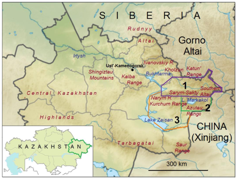
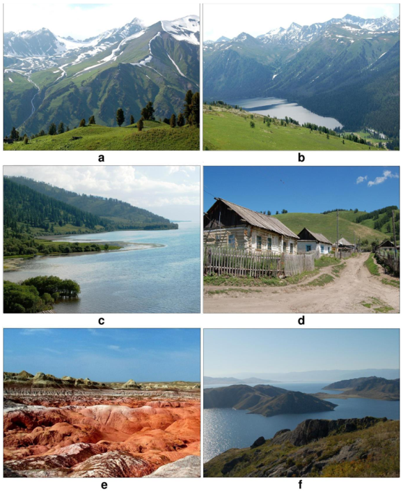
2. Study Area

3. Research Aims, Methods and Approaches

| Indicator | Characteristics | Qualitative Scale (Points) | Weighting Coefficient | ||
|---|---|---|---|---|---|
| 0 | 1 | 2 | |||
| Relief | Density of linear erosion network (km/km2) | >2.5 | 2.5–0.8 | <0.8 | 1.2 |
| Vertical relief gradient (m) | <300 | 300–800 | >800 | 1.8 | |
| Altitude (m asl.) | 0–500 | 500–1000 | >1000 | 1.5 | |
| Slope steepness (degree) | 0–6 | 6–12 | >12 | 1.3 | |
| Climate | Average January temperature | −25 °C | −19 °C | −9 °C | 1.3 |
| Average July temperature (°C) | 11–15 °C | 16–19 °C | 20–25 °C | 1.7 | |
| Average annual precipitation (mm) | 600–800 | 400–600 | 300–400 | 1.2 | |
| Duration of stable snow cover (days) | 0–140 | 140–160 | >160 | 1.3 | |
| Duration of daily air temperature above 0 °C (days) | <160 | 160–190 | >190 | 1.0 | |
| Hydrography | Coastline of water bodies (km) | absent | < 2 km | >2 km | 1.0 |
| Mineral springs | Frequency of mineral water occurrence in OTU | absent | < 1 | >1 | 2.0 |
| Balneology | Mud treatment occurrence | absent | present | 2.0 | |
| Biodiversity | Number of landscape species within 1 OTU | 0–6 | 6–12 | >12 | 1.5 |
| Number of medical and food plants within 1 OTU | 0–6 | 6–12 | >12 | 1.0 | |
| Flora listed in the Red Book (species in 1 OTU) | 0–6 | 6–12 | >12 | 1.3 | |
| Number of species (fauna) | 0–6 | 6–12 | >12 | 1.4 | |
| Fauna listed in the Red Book (species in 1 OTU) | 0–6 | 6–12 | >12 | 1.6 | |
| Geodiversity | Unique natural geosites | absent | present | 0.9–1.0 | |
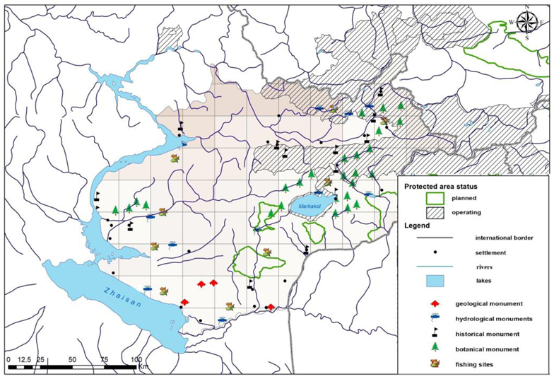
| Protected natural areas | Total extent (SPNA) * (% coverage area) | absent | <50% | >50% | 1.1 |
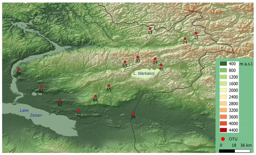
| Mapped Operational Territorial Units (OTU) | Geographic Location | Weighting Factor Presence of Natural/Cultural Monuments) | Geoheritage Sites (Protected Natural Areas) | ||
|---|---|---|---|---|---|
| Bi | |||||
| Kurchum Natural Recreational Area | |||||
| OTU55 | 85°07′56.0″ E 48°32′07.9″ N | 1.0 | 3 | Kalzhyr gorge | |
| OTU62 | 84°16′42.4″ E 48°16′50.3″ N | 1.0 | 4 | Kalguty River confluence site | |
| OTU39 | 83°33′11.4″ E 48°48′21.9″ N | 1.0 | 5 | Kurchum, Tabiti rock petroglyphs | |
| OTU51 | 83°56′58.8″ E 48°30′57.6″ N | 1.0 | 5 | Moinak petroglyphs Kurchum River | |
| OTU72 | 84°36′13.8″ E 48°6′18.30″ N | 1.0 | 5 | Kiin-Kerish & Kyzyl-Kerish badlands | |
| Katon-Karagay National Park | |||||
| OTU13 | 85°51′16.7″ E 49°30′7.2″ N | 1.0 | 3 | Lake Yazovoe | |
| OTU33 | 85°38′27.8″ E 49°01′8.50″ N | 1.0 | 3 | Katon-Karagay geo-exposition | |
| OTU15 | 86°39′38.9″ E 49°25′23.0″ N | 1.0 | 5 | Kokkol mine Kokkol waterfall | |
| OTU24 | 86°28′5.0″ E 49°19′53.4″ N | 1.0 | 5 | Lake Rahman | |
| OTU34 | 85°56′31.3″ E 48°59′27.5″ N | 1.0 | 5 | Berel’ Scythian royal burial mounds | |
| Markakol Natural Recreational Area | |||||
| OTU 65 | 85°24′58.3″ E 48°16′56.6″ N | 1.0 | 3 | Mynshunkyr salt pits | |
| OTU 64 | 84°53′48.3″ E 48°21′17.6″ N | 1.0 | 4 | Kalzhyr Gorge | |
| OTU74 | 85°23′24.4″ E 48°03′47.4″ N | 1.0 | 5 | Ashutas, Black Irtysh (paleobotany and geology) | |
| OTU46 | 86°2′51.2″ E 48°53′11.2″ N | 1.0 | 5 | Markakol Nature Reserve, Austrian road | |

4. Results
4.1. The Katon-Karagay Area
4.2. The Lake Markakol Area
4.3. The Kurchum Area
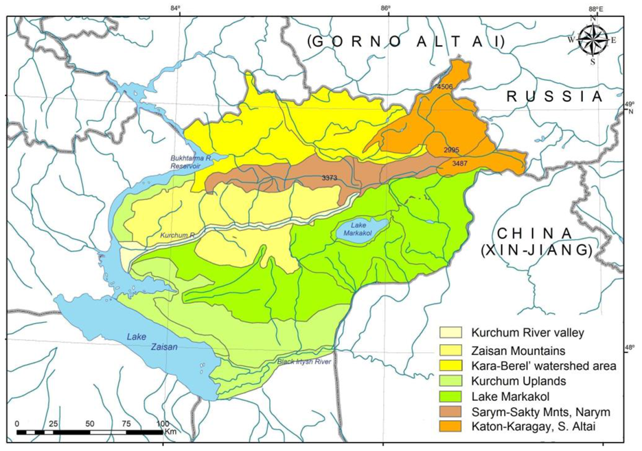
| Geographic Recreation Area | Altitude (m asl.) | Geomorphic Settings | Geology | Soil Cover | Vegetation/Biotopes | |
|---|---|---|---|---|---|---|
| Kurchum R. Valley | 700–1500 | Alluvial plain River delta Fluvial terraces | Fluvial deposits Slope colluvia (sandy-gravels) | Chestnut soils Luvisols | Parklands Coniferous taiga Xerophytic shrubs | |
| Zaisan Mountains | 200–500 | Low-elevation hills Intermontane plain Alluvial fans | Sedimentary Metamorphic bedrock | Brunisols Solonchaks Solonets | Mixed taiga Xerophytic salt-adapted plants | |
| Kara-Berel’ Watershed Area | 2000–3850 | High-elevation mnt and rocky foothill denudations, loess | Igneous Metamorphic Sedimentary form. | Regosols Brunisols Chernozems | (Sub-)alpine meadows Coniferous taiga Parklands | |
| Kurchum Uplands | 500–700 | Mid-elevation hills Deflation surfaces Sand-dune fields | Metamorphic Sedimentary form. quartzite, sandstone | Brunisols Podzols Regosols | Coniferous taiga (larch-spruce-fir) Semi-desert steppe | |
| Lake Markakol | 1000–1500 | Mid-elevation mnts Tectonic depression Erosional valleys | Metamorphic Sedimentary form (quartz, limestone) | Podzols Brunisols Chestnut soils | Coniferous taiga (larch-spruce-fir) Mixed shrub-.taiga | |
| Sarym-Sakty Mnts Narym Plateau | 2000–3500 | High mountains Orogenic plateau Palaeo-glacial relief | Metamorphic Igneous (gneiss, granite) | Brunisols Podzols Regosols | Xeric fescue-steppe Alpine meadows Shrubs (larch-spruce) | |
| Katon-Karagay NP (Southern Altai) | 1500–4500 | High mountains Glacial landscape Gravity deposits | Metamorphic Igneous (granite, gabbro) | Brunisols Podzols Regosols | Dark coniferous taiga Shrubs (birch, willow) Alpine meadow, tundra |


5. Discussion: The Altai Geo- and Eco-Tourism Sustainability and Perspectives

6. Conclusions
Author Contributions
Funding
Institutional Review Board Statement
Informed Consent Statement
Data Availability Statement
Acknowledgments
Conflicts of Interest
References
- Pavlichenko, L.; Shakirova, K. Territorial differentiation of tourist-recreational potential of the almaty region. Int. Acad. J. Web Sch. 2019, 5, 3–8. [Google Scholar] [CrossRef]
- Akbar, I.; Yang, Z.; Mazbayev, O.; Seken, A.; Udahogora, M. Local residents participation in tourism at a world heritage site and limitations, Aksu-Jabagly State Nature Reserve, Western Tian-Shan, Kazakhstan. Geoj. Tour. Ageosites 2020, 28, 35–51. [Google Scholar] [CrossRef]
- Makenova, G.; Tuleubayeva, M.; Issayeva, A.; Daurembekova, A. Analysis of the Development of International Tourism and Its Impact to Tourism Market: Evidence of Kazakhstan. J. Environ. Manag. Tour. 2020, 11, 2053–2067. [Google Scholar]
- Yegorina, A.; Saparov, K.; Zhensikbayeva, N. The Structure of the Geo-Cultural Space of Southern Altai as a Factor of Tourist-Recreational Development, Vestnik КNU. Sci. J. 2016, 1, 214–219. [Google Scholar]
- Chlachula, J. Geo-Tourism Perspectives in East Kazakhstan. Geogr. Environ. Sustain. 2019, 12, 29–43. [Google Scholar] [CrossRef]
- Toops, S. Tourism in Xinjiang, China. J. Cult. Geogr. 1992, 12, 19–34. [Google Scholar] [CrossRef]
- Zhang, C.M. Division and development strategy of tourism in Altay prefecture, Xinjiang. Arid Land Geogr. 1999, 22, 20–26. [Google Scholar]
- Yang, J.; Ryan, C.; Zhang, L. Sustaining culture and seeking a Just Destination: Governments, power and tension—A life-cycle approach to analysing tourism development in an ethnic-inhabited scenic area in Xinjiang, China. J. Sustain. Tour. 2014, 22, 1151–1174. [Google Scholar] [CrossRef]
- Wang, Z.; Yang, Z.; Wall, G.; Xua, X.; Hana, F.; Dua, X.; Liua, W. Is it better for a tourist destination to be a World Heritage Site Visitors’ perspectives on the inscription of Kanas on the World Heritage List in China. J. Nat. Conserv. 2014, 23, 19–26. [Google Scholar] [CrossRef]
- Garms, E.; Sukhova, M.; Kocheeva, N.; Minaev, A.; Kranin, A. On the concept of sustainable recreational use of natural resources of cross-border areas of Altai. J. Environ. Manag. Tour. 2016, 2, 313–320. [Google Scholar]
- Sukhova, M.; Garms, E.; Babin, V.; Zhuravleva, O.; Karanin, A. Functional Zoning as an Instrument for Sustainable De-velopment of Tourism of Great Altai. Int. J. Environ. Sci. Educ. 2016, 11, 7506–7514. [Google Scholar]
- Baryshnikova, O.N.; Rotanova, I.N.; Silantyeva, M.M.; Kharlamova, N.F. Factors of the formation of landscape diversity of the natural park “Foothills of the Altai” and ways to preserve it. Acta Biol. Sib. 2017, 3, 23–31. [Google Scholar] [CrossRef]
- Chlachula, J. Pleistocene climate change, natural environments and Palaeolithic peopling of East Kazakhstan. In Eurasian Perspectives of Environmental Archaeology. Quat. Int. 2010, 220, 64–87. [Google Scholar] [CrossRef]
- Chlachula, J. Environmental context of the prehistoric occupation of the Southern Altai (SW Siberia—East Kazakhstan). Archaeol. Anthropol. Sci. 2019, 11, 2215–2236. [Google Scholar] [CrossRef]
- Polosmak, N. Inhabitants of Ukok; Infolio Press: Novosibirsk, Russia, 2001; p. 334. [Google Scholar]
- Samashev, Z. Archaeological Monuments of the Kazakh Altai; Institute of Archaeology: Almaty, Kazakhstan, 2001; p. 108. [Google Scholar]
- Molodin, V.I.; Polosmak, N.V.; Novikov, A.V.; Bogdanov, E.S.; Slyusarenko, I.Y.; Sheremisin, D.V. Archaeological Monuments of the Plateau Ukok (Gorno Altai); IAET SB RAS: Novosibirsk, Russia, 2004; p. 255. [Google Scholar]
- Gorbunov, A.; Samashev, Z.; Severskiy, E. Treasures of Frozen Kurgans of the Kazakh Altai, Materials of the Berel’ Burial Ground, Il; Tech-Kitap Press: Almaty, Kazakhstan, 2005; p. 114. [Google Scholar]
- Chlachula, J. Biodiversity and environmental protection of southern Altai. Stud. Sicomun. Stiintelenaturii 2011, 27, 171–178. [Google Scholar]
- Yegorina, A. Physical Geography of East Kazakhstan; EHI Publishing House: Ust-Kamenogorsk, Kazakhstan, 2002; p. 181. [Google Scholar]
- Chlachula, J. Geoheritage of East Kazakhstan. Geoheritage 2020, 12, 1–17. [Google Scholar] [CrossRef]
- Nekhoroshev, V. Geology of the Altai; Gosgeoltekhizdat: Moscow, Russia, 1958; p. 262. [Google Scholar]
- Nekhoroshev, V. Eastern Kazakhstan. Geological Structure. In Geology of the USSR; Sidorenko, A., Ed.; Nauka: Mos-kva–Leningrad, 1967; p. 467. (In Russian) [Google Scholar]
- Braden, K.; Prudnikova, N. The Challenge of Ecotourism Development in the Altay Region of Russia. Tour. Geogr. 2008, 10, 1–21. [Google Scholar] [CrossRef]
- Sukhova, M.; Garms, E. Bioclimatic conditions of Russian Altai Kray landscapes as a factor of sustainable tourism development. World Appl. Sci. J. 2014, 30, 187–189. [Google Scholar]
- Zhensikbayeva, N.; Saparov, K.; Atasoy, E.; Kulzhanova, S.; Wendt, J. Determination of Southern Altai geography propitiousness extent for tourism development. Geoj. Tour. Geosites 2017, 20, 158–164. [Google Scholar]
- Chlachula, J. Environmental Management in the Context of Sustainable Development of Southern Altai (Katon-Karagay State Nature Park): Final Report; Irbis: Stare Mesto, Czech Republic, 2007; p. 152. [Google Scholar]
- Liao, C.; Sullivan, P.; Barrett, C.; Kassam, K. Socioenvironmental threats to pastoral livelihoods: Risk perceptions in the Altay and Tianshan Mountains of Xinjiang, China. Risk Anal. 2013, 34, 640–655. [Google Scholar] [CrossRef] [PubMed]
- Korneevets, V.S.; Redkin, A.G.; Studzieniecki, T.; Zaitseva, N.A. Influence of border regions relations on the tourist choices of the population. Geoj. Tour. Geosites 2019, 25, 569–579. [Google Scholar] [CrossRef]
- Dowling, R.K.; Newsome, D. Global Geotourism Perspectives; Goodfellow Publishers Woodeaton: Oxford, UK, 2010. [Google Scholar]
- Frey, M.-L. Geotourism—Examining Tools for Sustainable Development. Geoscience 2021, 11, 30. [Google Scholar] [CrossRef]
- Brocx, M. Geoheritage: From Global Perspectives to Local Principles for Conservation and Planning; Western Australian Museum: Welshpool, Australia, 2008. [Google Scholar]
- Gordon, J.E.; Crofts, R.; Díaz-Martínez, E. Geoheritage conservation and environmental policies: Retrospect and prospect. In Geoheritage; Reynard, E., Brilha, J., Eds.; Elsevier: Chennai, India, 2018; pp. 213–236. [Google Scholar]
- Fennel, D. Ecotourism; Routledge: Boca Raton, FL, USA, 2020; p. 165. [Google Scholar]
- Robinson, A. Geotourism: Who is the Geotourist? In Proceedings of the Inaugural National Australian Conference on Green Travel, Climate Change and Ecotourism, Adelaide, Australia, 17–20 November 2008; p. 215. [Google Scholar]
- Blamey, R. Principles of Ecotourism. In The Encyclopedia of Ecotourism; Weaver, E.B., Ed.; CAB International: Wallingford, UK, 2001. [Google Scholar]
- Dowling, R.K. Global Geotourism—An Emerging Form of Sustainable Tourism. Czech J. Tour. 2013, 2, 59–79. [Google Scholar] [CrossRef]
- Chupakhin, V. Physical Geography of Kazakhstan; Mektep Press: Almaty, Kazakhstan, 1968; p. 260. [Google Scholar]
- Rudoy, A.N.; Lysenkova, Z.V.; Rudskiy, V.V.; Shishin, M.Y. Ukok. The Past, Present and Future; Altai State University Press: Barnaul, Russia, 2000; p. 174. [Google Scholar]
- Veselova, L. Morphostructure of the South-Eastern Kazakhstan Mountains. In Geography of Desertic and Mountain Region of Kazakhstan; Nauka: Moskva–Leningrad, Russia, 1970; pp. 38–48. [Google Scholar]
- Dyachkov, B.A.; Mayorova, N.P.; Chernenko, Z.I. History of East Kazakhstan Geological Structures Development in the Her-Cynian, Cimmerian and Alpine Cycles of Tectonic Genesis, Part II. Proceedings of the Ust-Kamenogorsk Kazakh Geographical Society; Serikbaev, D., Ed.; East Kazakhstan State Technical University Press: Ust-Kamenogorsk, Kazakhstan, 2014; pp. 42–48. [Google Scholar]
- Dodin, A. Principal Characteristics of the Geological Structure and Genesis of the Eastern Part of the Altai-Sayan Structural Zone. Natural Conditions of the Krasnoyarsk Region; Nauka: Moskva, Russia, 1961; pp. 99–125. [Google Scholar]
- Svarichevskaya, E. Geomorphology of Kazakhstan and Central Asia; Nauka: Leningrad, Russia, 1965; p. 296. [Google Scholar]
- Deviatkin, E.V. The Cainozoic of the Inner Asia; Nauka: Moskva, Russia, 1981; 196p. [Google Scholar]
- Aubekerov, B.Z. Stratigraphy and Paleogeography of the Plain Zones of Kazakhstan During the Late Pleistocene and Hol-ocene. In Development of Landscape and Climate in Northern Asia in Late Pleistocene and Holocene; Nauka: Moskva, Russia, 1993; Volume 1, pp. 101–110. [Google Scholar]
- Baibatsha, A.; Aubekerov, B. Quaternary Geology of Kazakhstan; Niz Flym: Almaty, Kazakhstan, 2003; p. 147. [Google Scholar]
- Sherba, G.N.; Bespayev, X.A.; Dyachkov, B.A. The Great Altai (Geology and Metallogeny); RIO VAC RK: Almaty, Kazakhstan, 2000; p. 400. [Google Scholar]
- Gavrilenko, E.V.; Calvo Pérez, B.; Castroviecho Bolivar, R.; Garcia del Amo, D. Emeralds from the Delbegetey deposit (Ka-zakhstan): Mineralogical characteristics and fluid-inclusion study. Mineral. Mag. 2006, 70, 159–173. [Google Scholar] [CrossRef]
- Mikhailov, N. Mountains of Southern Siberia; Nauka: Moskva, Russia, 1961; p. 296. [Google Scholar]
- Rudoy, A. Gigantic flows—the evidence of catastrophic outbursts of glacial lakes of Gorno Altai. In Current Geomorphic Processes on the Territory of the Altai; University Press: Biysk, Russia, 1984; pp. 60–64. [Google Scholar]
- Rudoy, A. Mountain Ice-Dammed Lakes of Southern Siberia and Their Influence on the Development and Regime of the Intracontinental Runoff Systems of North Asia in the Late Pleistocene. In Palaeohydrology and Environmental Change; Benito, G., Baker, A., Gregory, K., Eds.; John Willey & Sons: Hoboken, NJ, USA, 1998; pp. 215–234. [Google Scholar]
- Baker, V.R.; Benito, G.; Rudoy, A.N.; Briggs, D.E.G.; Kear, A.J. Paleohydrology of Late Pleistocene Superflooding, Altay Mountains, Siberia. Science 1993, 259, 348–350. [Google Scholar] [CrossRef]
- Ganyushkin, D.A.; Chistyakov, K.V.; Volkov, I.V.; Bantcev, D.V.; Kunaeva, E.P.; Terekhov, A.V. Present Glaciers and Their Dynamics in the Arid Parts of the Altai Mountains. Geosciences 2017, 7, 117. [Google Scholar] [CrossRef]
- Pachikin, K.; Erokhina, O.; Funakawa, S. Soils of Kazakhstan, Their Distribution and Mapping. In Spatial Modeling in Forest Resources Management; Springer International Publishing: Berlin/Heidelberg, Germany, 2014; pp. 519–533. [Google Scholar]
- Yegorina, A. The Climate of Southwest Altai; Semipalatinsk University Press: Semey, Kazakhstan, 2015; p. 315. [Google Scholar]
- Weather and Climate of Kazakhstan. 2021. Available online: https://weather-and-climate.com/average-monthly-Rainfall-Temperature-Sunshine-in-Kazakhstan (accessed on 9 March 2021).
- Baibatsha, A. The Ancient History of the Kazakh Steppe; Sanat Press: Almaty, Kazakhstan, 1998; p. 46. [Google Scholar]
- Saparov, K.; Chlachula, J.; Yeginbayeva, A. Toponymy of the Ancient Sary-Arka (North-Eastern Kazakhstan). Quaest. Geogr. 2018, 37, 35–52. [Google Scholar] [CrossRef]
- Zhensikbayeva, N.; Saparov, K.; Chlachula, J.; Yegorina, A.; Uruzbayeva, N.; Wendt, J. Natural potential for tourism development in Southern Altai (Kazakhstan). Geoj. Tour. Geosites 2018, 21, 200–212. [Google Scholar]
- Kabdrakhmanova, N.K.; Mussabayeva, M.N.; Atasoy, E.; Zhensikbayeva, N.Z.; Kumarbekuly, S. Landscape and recreational analysis of Yertis river upper part on the basis of basin approach (Kazakhstan). Geoj. Tour. Geosites 2019, 27, 1392–1400. [Google Scholar] [CrossRef]
- Velikovskaya, E.M. Relief Development of the Southern Altai and Kalba and Deep Gold Placers. Bull. Mosc. Inst. Petrol. 1946, 21, 57–77. [Google Scholar]
- El Wartiti, M.; Malaki, A.; Zahraoui, M.; El Ghannouchi, A.; Gregorio, F. Geosites inventory of the northeastern Tabular Middle Atlas of Morocco. Environ. Geol. 2008, 55, 415–422. [Google Scholar] [CrossRef]
- Zwoliński, Z.; Stachowiak, J. Geodiversity map of the Tatra National Park for geotourism. Quaest. Geogr. 2012, 31, 99–107. [Google Scholar] [CrossRef]
- Hose, T. Geoheritage and Geotourism: A European Perspective. In The Heritage Matters Series; Boydell Press: Newcastle University, Woodbridge, UK, 2016; p. 336. [Google Scholar]
- Krupochkin, E.; Dunets, A. Some methodological aspects of of the tourism-recreational assessment of the territorial planning. News Altai State Univ. 2011, 3, 108–113. [Google Scholar]
- Dunets, A. Tourist and Recreational Complexes of Mountain Region; ASU Publishing House: Barnaul, Russia, 2011; p. 150. [Google Scholar]
- Wimbledon, W.; Smith-Meyer, S. Geoheritage in Europe and Its Conservation; ProGEO: Oslo, Norway, 2012; p. 405. [Google Scholar]
- Yegorina, A.; Loginovskaya, A. Geographical Aspects of Recreation and Tourism Development in East Kazakhstan. Experience and Practice; Shygys Polygraf: Ust-Kamenogorsk, Kazakhstan, 2016; p. 146. (In Russian) [Google Scholar]
- Bayandinova, S.; Mamutov., Z.; Ispanova, G. Man-Made Ecology of East Kazakhstan; Springer Nature Press: Singapore, 2018; p. 136. [Google Scholar]
- Earth Explorer. In SRTM 1 Arc-Second Global; 2020. Available online: https://earthexplorer.usgs.gov/. (accessed on 9 March 2021).
- Mandych, A. Conditions and Trends in Natural Systems of the Altai-Sayan Ecoregion; Springer International Publishing: Berlin/Heidelberg, Germany, 2006; pp. 231–275. [Google Scholar]
- Vaganov, A. Prospects for studying and preserving the biodiversity of the Altai-Sayan ecoregion in the context of the devel-opment of open databases. Ukr. J. Ecol. 2018, 8, 380–392. [Google Scholar] [CrossRef]
- Samashev, Z. Berel’; Ministry of Education and Science, Archaeological Institute; Taimas Press: Astana, Kazakhstan, 2011; p. 236. [Google Scholar]
- Samashev, Z. Tsar Valley; Archaeological Institute: Astana, Kazakhstan, 2014; p. 236. [Google Scholar]
- Caisová, L.; Bašta, T.; Chlachula, J.; Komárek, J.; Husák, S. Taxonomic investigations of the crynobacterial and algal microflora from the Katon-Karagay National Park (Altai, East Kazakhstan). Biodivers. Res. Conserv. 2010, 15, 45–54. [Google Scholar]
- Hradílek, Z.; Chlachula, J.; Nesterova, S. New bryophyte records from Kazakhstan. Thaiszia J. Bot. 2011, 21, 29–36. [Google Scholar]
- Page, K.N. Fossils, Heritage and Conservation: Managing Demands on a Precious Resource. In Geoheritage; Reynard, E., Brilha, J., Eds.; Elsevier: Amsterdam, The Netherlands, 2018; pp. 107–128. [Google Scholar]
- Baumer, C. The History of Central Asia. The Age of the Silk Roads; I.B. Tauris Press: London, UK, 2016; Volume 2, p. 288. [Google Scholar]
- Kiernan, K. Landforms as Sacred Places: Implications for Geodiversity and Geoheritage. Geoheritage 2014, 7, 177–193. [Google Scholar] [CrossRef]
- Gusev, A.I. The Altay Geoheritage and Gemology with the Basis of the Gemmo-Tourism; Biysk State University Press: Byisk, Russia, 2007; p. 187. [Google Scholar]
- Chlachula, J. Gemstones of Еastern Kazakhstan. Geologos 2020, 26, 125–148. [Google Scholar] [CrossRef]
- Agakhanjanz, O.; Breckle, S. Plant Diversity and Endemism in High Mountains of Central Asia, the Caucasus and Siberia. In Mountain Diversity—A Global Assessment; Koerner, C., Spehn, E., Eds.; Routledge: Boca Raton, FL, USA, 2002; pp. 117–128. [Google Scholar]
- Myrzagalieva, A.B.; Chlachula, J. Medical Plants of the Altai; 2021; p. 15, Unpublished manuscript. [Google Scholar]
- Agrawala, S. Climate Change in the European Alps: Adapting Winter Tourism and Natural Hazards Management; OECD: Paris, France, 2007; p. 136. [Google Scholar]
- Morisson, C.; Pickering, C. Perceptions of climate change impacts, adaptation and limits to adaption in the Australian Alps: The ski-tourism industry and key stakeholders. J. Sustain. Tour. 2012, 21, 173–191. [Google Scholar] [CrossRef]
- Pepin, N.; Bradley, R.S.; Diaz, H.F.; Baraer, M.; Caceres, E.B.; Forsythe, N.; Fowler, H.J.; Greenwood, G.; Hashmi, M.Z.; Liu, X.D.; et al. Elevation-dependent warming in mountain regions of the world. Nat. Clim. Chang. 2015, 5, 424–430. [Google Scholar] [CrossRef]
- Hammer, T.; Siegrist, D. Protected Areas in the Alps: The Success Factors of Nature-Based Tourism and the Challenge for Regional Policy. Gaia Ecol. Perspect. Sci. Soc. 2008, 17, 152–160. [Google Scholar] [CrossRef]
- Wendt, J.A. Directions and areas of tourism research in Kazakhstan. Geoj. Tour. Geosites 2020, 32, 1418–1424. [Google Scholar] [CrossRef]
- Selezneva, E.V.; Rotanova, I.N. Ecological background of the transboundary protected touristic territory in Western Altai. Ukr. J. Ecol. 2019, 9, 709–712. [Google Scholar] [CrossRef]
- Dunets, A.; Zhogova, I.; Sycheva, I. Common characteristics in the organization of tourist space within mountainous regions: Altai-Sayan Region (Russia). Geoj. Tour. Geosites 2019, 24, 161–174. [Google Scholar]
Publisher’s Note: MDPI stays neutral with regard to jurisdictional claims in published maps and institutional affiliations. |
© 2021 by the authors. Licensee MDPI, Basel, Switzerland. This article is an open access article distributed under the terms and conditions of the Creative Commons Attribution (CC BY) license (http://creativecommons.org/licenses/by/4.0/).
Share and Cite
Chlachula, J.; Zhensikbayeva, N.Z.; Yegorina, A.V.; Kabdrakhmanova, N.K.; Czerniawska, J.; Kumarbekuly, S. Territorial Assessment of the East Kazakhstan Geo/Ecotourism: Sustainable Travel Prospects in the Southern Altai Area. Geosciences 2021, 11, 156. https://doi.org/10.3390/geosciences11040156
Chlachula J, Zhensikbayeva NZ, Yegorina AV, Kabdrakhmanova NK, Czerniawska J, Kumarbekuly S. Territorial Assessment of the East Kazakhstan Geo/Ecotourism: Sustainable Travel Prospects in the Southern Altai Area. Geosciences. 2021; 11(4):156. https://doi.org/10.3390/geosciences11040156
Chicago/Turabian StyleChlachula, Jiri, Nazgul Zh. Zhensikbayeva, Anna V. Yegorina, Nazym K. Kabdrakhmanova, Jolanta Czerniawska, and Sanat Kumarbekuly. 2021. "Territorial Assessment of the East Kazakhstan Geo/Ecotourism: Sustainable Travel Prospects in the Southern Altai Area" Geosciences 11, no. 4: 156. https://doi.org/10.3390/geosciences11040156
APA StyleChlachula, J., Zhensikbayeva, N. Z., Yegorina, A. V., Kabdrakhmanova, N. K., Czerniawska, J., & Kumarbekuly, S. (2021). Territorial Assessment of the East Kazakhstan Geo/Ecotourism: Sustainable Travel Prospects in the Southern Altai Area. Geosciences, 11(4), 156. https://doi.org/10.3390/geosciences11040156