
Geological Heritage of Syros Island, Cyclades Complex, Greece: An Assessment and Geotourism Perspectives

 ,
, 
Abstract
1. Introduction
2. Study Area
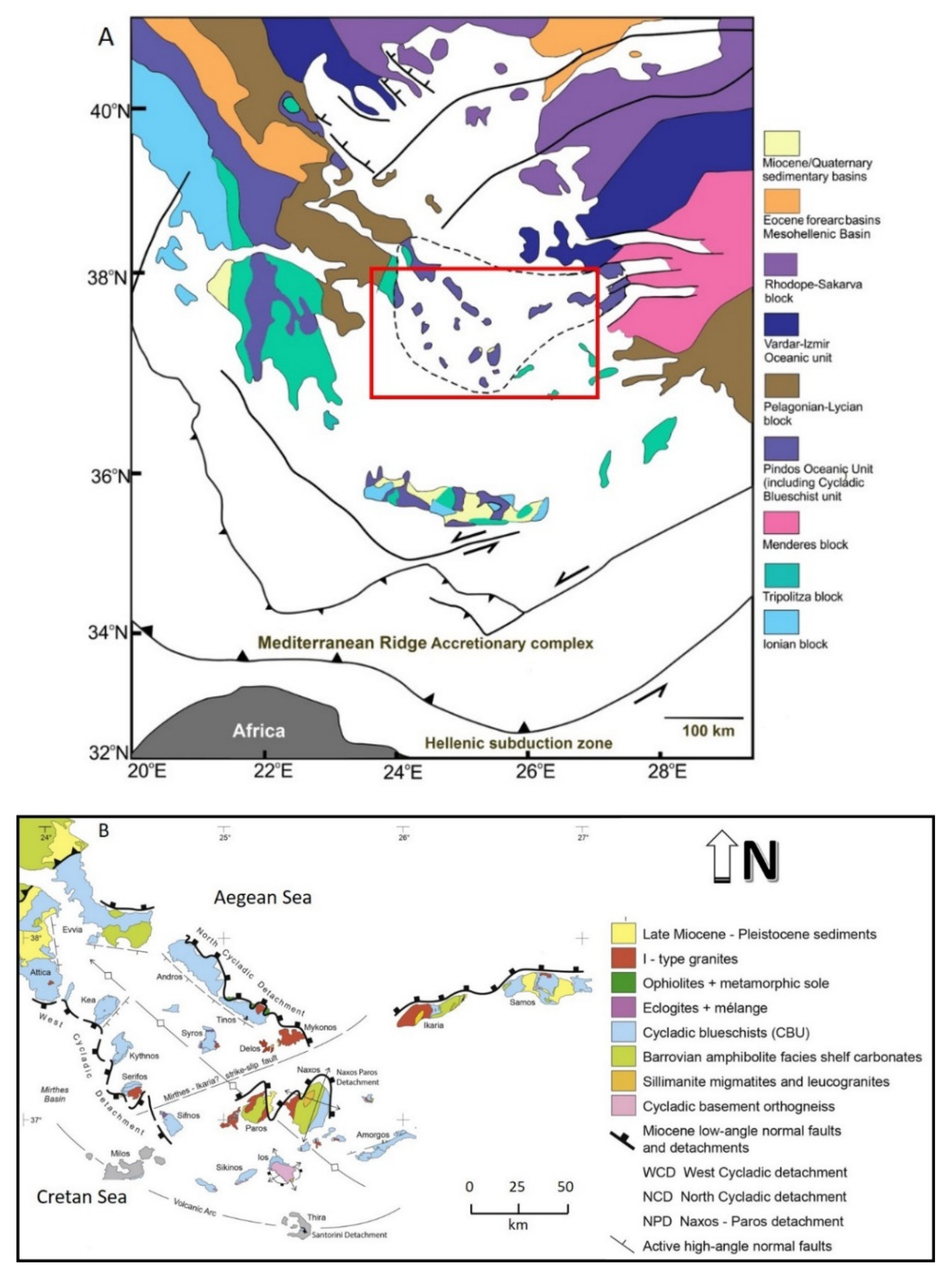
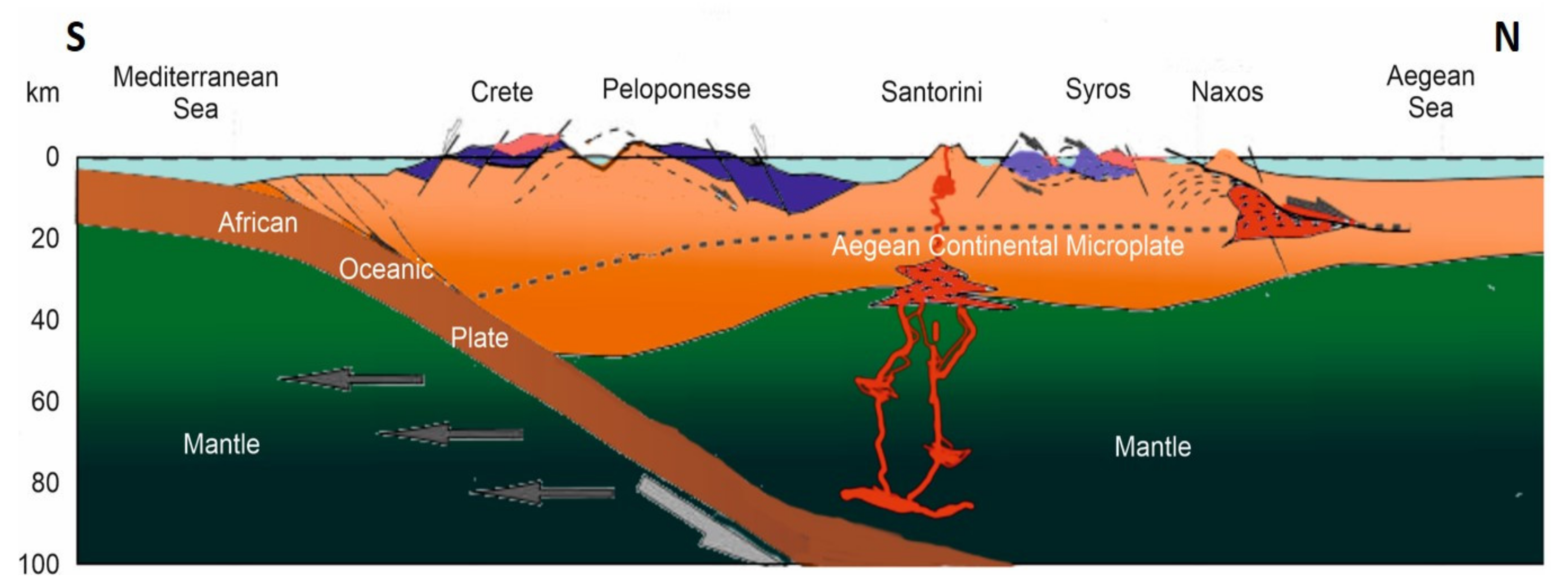
Geological Setting
3. Methodology
4. Results
4.1. Qualitative Evaluation of the Geological Heritage of Syros
4.2. Quantitative Evaluation of Geotourism Potential
4.3. SWOT Analysis
5. Discussion
5.1. Geotourism Potential of Syros Island
- “Development of a Management Plan and a Four-Year Action Plan” and “Detailed presentation of the Geotopes of Syros and their Evaluation”,
- Creation of Interpretation and Centers of geotopes, which function as information centers, and
- Creation of outdoor geological routes and museums with placement of signs in the geotopes of interest and markings on the geotrails.
5.2. The Archaeological and Cultural Framework of Syros Island
5.3. Institutional Geoheritage Framework
5.4. Future Perspectives
5.5. Recommendations
- Geosite inventory: An inventory comprising the various geosites of Syros island, must be created and discussed. Regarding the geological information and the interests of geodiffusion, we plan to show, describe, and explain the preserved evidence of processes active in deep levels of orogens, and then explain the birth and development of an orogeny. Geo-diffusion activities undertaken encompass concepts and configuration of geological trails along the most impressive and indicative cross sections, most of which are dedicated to displaying characteristics of these processes.
- Capacity building: Geological experts obtain information through literature collection and on-the-spot investigations, and then translate scientific data into popular materials that the public can understand. Through continuous and hierarchical training including the seed narrator training, environmental education for students of primary and high school, etc., to learn about the land where you live, and to introduce the story of their hometown;
- Networking activities: In order to continuously improve the ability of community residents to promote the geopark, to share the experience promoted by domestic and foreign geoparks. Networking activities involve the organization of conferences, workshops, training courses, field studies, production, and presentation of local geo-products, among others. Moreover, through interviews with community cadres and the public, surveys and inventory of resources will be conducted with the community to understand the geology, landscape, human history, ecology, and agricultural specialties that they own, as applicable resources for the geopark;
- Development and production of promotional material: To promote the geopark, increase the elements and characteristics of the territory, scholars and community residents jointly carry out the LOGO design of the Syros Geopark, and make folding, postcards, bags, books, brochures, among others.
6. Conclusions
- of fundamental processes operating in an oceanic subduction zone
- of the geological evolution of Syros over some 60 million years
- of human culture and evolution on Syros over 8000 years.
Author Contributions
Funding
Institutional Review Board Statement
Informed Consent Statement
Data Availability Statement
Acknowledgments
Conflicts of Interest
References
- Goudie, A.G. Encyclopedia of Geomorphology; Routledge: London, UK, 2004. [Google Scholar]
- Zouros, N.; Valiakos, I. Geoparks Management and Assessment. Bull. Geol. Soc. Greece 2017, 43, 965–977. [Google Scholar] [CrossRef]
- Fassoulas, C.; Zouros, N. Evaluating the Influence of Greek Geoparks to The Local Communities. Bull. Geol. Soc. Greece 2017, 43, 896. [Google Scholar] [CrossRef]
- Stoffelen, A.; Groote, P.; Meijles, E.; Weitkamp, G. Geoparks and territorial identity: A study of the spatial affinity of inhabitants with UNESCO Geopark De Hondsrug, The Netherlands. Appl. Geogr. 2019, 106, 1–10. [Google Scholar] [CrossRef]
- Eder, F.W. Geoparks—Geological attractions: A tool for public education, recreation and sustainable economic development. Episodes 2004, 27, 162–164. [Google Scholar] [CrossRef] [PubMed]
- Zouros, N. The European Geoparks Network—Geological heritage protection and local development. Episodes 2004, 27, 165–171. [Google Scholar] [CrossRef]
- Fermeli, G. Geological-Geomorphological Heritage, Theory and Practice, Educational Tool for the Teaching and Assessment of Geology—Geography and Environmental Education; Post-Doctoral Research; University of Athens: Athens, Greece, 2004; p. 440. [Google Scholar]
- Theodosiou, E.; Fermeli, G.; Koutsouveli, A. Our Geological Heritage; Kaleidoskopion: Athens, Greece, 2006. [Google Scholar]
- Fassoulas, C.; Paragamian, K.; Iliopoulos, G. Identification and assessment of Cretan geotopes. Bull. Geol. Soc. Greece 2007, 40, 1780–1795. [Google Scholar] [CrossRef]
- Psychogiou, M.; Georgiou, K.; Antonarakou, A.; Drinia, H. A field trip enhanced with ARTutor, an augmented reality educational platform. Eur. Geol. Eur. Geol. 2019. Available online: https://eurogeologists.eu/psychogiou-a-field-trip-enhanced-with-artutor-an-augmented-reality-educational-platform/ (accessed on 22 December 2020).
- Mariolakos, I. The Geo-Environmental Dimension of Greek Mythology. Bull Hell Geol Soc. 2002, 26, 2065–2086. [Google Scholar]
- Karamani, P.; Drinia, H.; Panagiaris, G. Geotourism as a tool for the protection and promotion of the Cave of Galaxidi. In Proceedings of the 15th International Congress of the Geological Society of Greece Athens, Athens, Greece, 22–24 May 2019. [Google Scholar]
- Kapsimalis, V.; Pavlopoulos, K.; Panagiotopoulos, I.; Drakopoulou, P.; Vandarakis, D.; Sakelariou, D.; Anagnostou, C. Geoarchaeological challenges in the Cyclades continental shelf (Aegean Sea). Z. Geomorphol. Suppl. Issues 2009, 53, 169–190. [Google Scholar] [CrossRef]
- Skentos, A. Geotopes of Greece. Master’s Thesis, University of Athens, Athens, Greece, 2012. [Google Scholar]
- Cliff, R.A.; Bond, C.E.; Butler, R.W.H.; Dixon, J.E. Geochronological challenges posed by continuously developing tectonometamorphic systems: Insights from Rb-Sr mica ages from the Cycladic Blueschist Belt, Syros (Greece). J. Metamorph. Geol. 2016, 35, 197–211. [Google Scholar] [CrossRef]
- Keiter, M.; Ballhaus, C.; Tomaschek, F. A new geological map of the Island of Syros (Aegean Sea, Greece): Implications for lithostratigraphy and structural history of the Cycladic Blueschist Unit. Geol. Soc. Am. Spec. Pap. 2011. [Google Scholar] [CrossRef]
- Keiter, M.; Piepjohn, K.; Ballhaus, C.; Lagos, M.; Bode, M. Structural development of high-pressure metamorphic rocks on Syros island (Cyclades, Greece). J. Struct. Geol. 2004, 26, 1433–1445. [Google Scholar] [CrossRef]
- Lagos, M.; Scherer, E.E.; Tomaschek, F.; Münker, C.; Keiter, M.; Berndt, J.; Ballhaus, C. High precision Lu–Hf geochronology of Eocene eclogite-facies rocks from Syros, Cyclades, Greece. Chem. Geol. 2007, 243, 16–35. [Google Scholar] [CrossRef]
- Laurent, V.; Jolivet, L.; Roche, V.; Augier, R.; Scaillet, S.; Cardello, G.L. Strain localization in a fossilized subduction channel: Insights from the Cycladic Blueschist Unit (Syros, Greece). Tectonophysics 2016, 672–673, 150–169. [Google Scholar] [CrossRef]
- Laurent, V.; Huet, B.; Labrousse, L.; Jolivet, L.; Monié, P.; Augier, R. Extraneous argon in high-pressure metamorphic rocks: Distribution, origin and transport in the Cycladic Blueschist Unit (Greece). Lithos 2017, 272–273, 315–335. [Google Scholar] [CrossRef]
- Lister, G.S.; Forster, M. White mica 40 Ar/39 Ar age spectra and the timing of multiple episodes of high-P metamorphic mineral growth in the Cycladic eclogite-blueschist belt, Syros, Aegean Sea, Greece. J. Metamorph. Geol. 2016, 34, 401–421. [Google Scholar] [CrossRef]
- Philippon, M.; Brun, J.-P.; Gueydan, F. Tectonics of the Syros blueschists (Cyclades, Greece): From subduction to Aegean extension. Tectonics 2011, 30. [Google Scholar] [CrossRef]
- Schumacher, J.C.; Brady, J.B.; Cheney, J.T.; Tonnsen, R.R. Glaucophane-bearing Marbles on Syros, Greece. J. Pet. 2008, 49, 1667–1686. [Google Scholar] [CrossRef]
- Soukis, K.; Stockli, D.F. Structural and thermochronometric evidence for multi-stage exhumation of southern Syros, Cycladic islands, Greece. Tectonophysics 2013, 595–596, 148–164. [Google Scholar] [CrossRef]
- Tomaschek, F.; Kennedy, A.K.; Villa, I.M.; Lagos, M.; Ballhaus, C. Zircons from Syros, Cyclades, Greece--Recrystallization and Mobilization of Zircon During High-Pressure Metamorphism. J. Pet. 2003, 44, 1977–2002. [Google Scholar] [CrossRef]
- Trotet, F.; Jolivet, L.; Vidal, O. Tectono-metamorphic evolution of Syros and Sifnos islands (Cyclades, Greece). Tectonophysics 2001, 338, 179–206. [Google Scholar] [CrossRef]
- Trotet, F.; Vidal, O.; Jolivet, L. Exhumation of Syros and Sifnos metamorphic rocks (Cyclades, Greece). New constraints on the P-T paths. Eur. J. Miner. 2001, 13, 901–920. [Google Scholar] [CrossRef]
- Jolivet, L.; Brun, J.-P. Cenozoic geodynamic evolution of the Aegean. Acta Diabetol. 2008, 99, 109–138. [Google Scholar] [CrossRef]
- Ring, U.; Glodny, J.; Will, T.; Thomson, S.N. The Hellenic subduction system: High pressure metamorphism, exhumation, normal faulting and large-scale extension. Ann. Rev. Earth Planet. Sci. 2010, 38, 45–76. [Google Scholar] [CrossRef]
- Stampfli, G.M. Tethyan Oceans. In Tectonics and Magmatism in Turkey and Surrounding Area; Bozkurt, E., Winchester, J.A., Piper, J.D.A., Eds.; Geological Society of London: London, UK, 2000; Volume 173, pp. 163–185. [Google Scholar]
- Malinverno, A.; Ryan, W.B.F. Extension in the Tyrrhenian Sea and shortening in the Apennines as result of arc migration driven by sinking of the lithosphere. Tectonics 1986, 5, 227–245. [Google Scholar] [CrossRef]
- Jolivet, L.; Faccenna, C. Meditterranean extension and the Africa-Eurasia collision. Tectonics 2000, 19, 1095–1106. [Google Scholar] [CrossRef]
- Jolivet, L.; Augier, R.; Faccenna, C.; Negro, F.; Rimmele, G.; Agard, P.; Robin, C.; Rossetti, F.; Blanc, A.C. Subduction, convergence and the mode of backarc extension in the Mediterranean region. BSGF Earth Sci. Bull. 2008, 179, 525–550. [Google Scholar] [CrossRef]
- Lister, G.S.; Banga, G.; Feenstra, A. Metamorphic core complexes of Cordilleran type in the Cyclades, Aegean Sea, Greece. Geology 1984, 12, 221–225. [Google Scholar] [CrossRef]
- Olivet, L.; Faccenna, C.; Huet, B.; Labrousse, L.; Le Pourhiet, L.; Lacombe, O.; Lecomte, E.; Burov, E.; Denèle, Y.; Brun, J.-P.; et al. Aegean tectonics: Strain localisation, slab tearing and trench retreat. Tectonophysics 2013, 597–598, 1–33. [Google Scholar] [CrossRef]
- Durr, S.; Altherr, R.; Keller, J.; Okrusch, M.; Seide, E. The Median Aegean Crystalline Belt: Stratigraphy, Structure, Metamorphism, Magmatism; Cloos, H., Roeder, D., Schmidt, K., Eds.; Alps, Apennines, Hellenides, Schweizerbart: Stuttgart, Germany, 1978; pp. 455–477. [Google Scholar]
- Schliestedt, M.; Altherr, R.; Matthews, A. Evolution of the Cycladic Crystalline Complex: Petrology, Isotope Geochemistry and Geochronolgy. In Chemical Transport in Metasomatic Processes; Springer International Publishing: Berlin/Heidelberg, Germany, 1987; pp. 389–428. [Google Scholar]
- Okrusch, M.; Bröcker, M. Eclogites associated with high-grade blueschists in the Cyclades archipelago, Greece: A review. Eur. J. Miner. 1990, 2, 451–478. [Google Scholar] [CrossRef]
- Bonneau, M. Correlation of the Hellenide nappes in the south-east Aegean and their tectonic reconstruction. Geol. Soc. London, Spec. Publ. 1984, 17, 517–527. [Google Scholar] [CrossRef]
- Okrusch, M.; Seidel, E.; Kreuzer, H.; Harre, W. Jurassic age of metamorphism at the base of the Brezovica peridotite (Yugoslavia). Earth Planet. Sci. Lett. 1978, 39, 291–297. [Google Scholar] [CrossRef]
- Matthews, A.; Schliestedt, M. Evolution of the blueschist and greenschist facies rocks of Sifnos, Cyclades, Greece. Contrib. Miner. Pet. 1984, 88, 150–163. [Google Scholar] [CrossRef]
- Bröcker, M.; Kreuzer, H.; Matthews, A.; Okrusch, M. 40Ar/39Ar and oxygen isotope studies of polymetamorphism from Tinos Island, Cycladic blueschist belt, Greece. J. Metamorph. Geol. 1993, 11, 223–240. [Google Scholar] [CrossRef]
- Brocker, M.; Baldwin, S.L.; Arkudas, R. The geological significance of 40 Ar/39 Ar and Rb-Sr white mica ages from Syros and Sifnos, Greece: A record of continuous (re)crystallization during exhumation? J. Metamorph. Geol. 2013, 31, 629–646. [Google Scholar] [CrossRef]
- Ring, U.; Thomson, S.N.; Bröcker, M. Fast extension but little exhumation: The Vari detachment in the Cyclades, Greece. Geol. Mag. 2003, 140, 245–252. [Google Scholar] [CrossRef]
- Kirchner, K.; Kubalíková, L. Relief assessment methodology with respect to geoheritage based on example of the Deblínská vrchovina highland. In Proceedings of the Public Recreation and Landscape Protection—With Man Hand in Hand? Brno, Czech Republic, 1–3 May 2013; Available online: http://www.utok.cz/sites/default/files/data/USERS/u24/Kirchner.pdf (accessed on 22 December 2020).
- Kubalíková, L.; Kirchner, K. Geosite and Geomorphosite Assessment as a Tool for Geoconservation and Geotourism Purposes: A Case Study from Vizovická vrchovina Highland (Eastern Part of the Czech Republic). Geoheritage 2016, 8, 5–14. [Google Scholar] [CrossRef]
- Nazaruddin, D.A. Systematic Studies of Geoheritage in Jeli District, Kelantan, Malaysia. Geoheritage 2017, 9, 19–33. [Google Scholar] [CrossRef]
- Ates, H.C.; Ateş, Y. Geotourism and Rural Tourism Synergy for Sustainable Development—Marçik Valley Case—Tunceli, Turkey. Geoheritage 2018, 11, 207–215. [Google Scholar] [CrossRef]
- Voudouris, P.; Mavrogonatos, C.; Graham, I.; Giuliani, G.; Tarantola, A.; Melfos, V.; Karampelas, S.; Katerinopoulos, A.; Magganas, A. Gemstones of Greece: Geology and Crystallizing Environments. Minerals 2019, 9, 461. [Google Scholar] [CrossRef]
- Katerinopoulou, A.; Katerinopoulos, A.; Bieniok, A.; Knop, E.; Magganas, A.; Amthauer, G. Crystal chemistry, structure analyses and phase transition experiment on an omphacite from eclogitic metagabbro from Syros island, Greece. Miner. Pet. 2007, 91, 117–128. [Google Scholar] [CrossRef]
- Hausmann, H. Beiträge zur Oryktographie von Syra. J. Praktische Chemie 1845, 34, 238–241. [Google Scholar] [CrossRef]
- Fassoulas, C.; Mouriki, D.; Dimitriou-Nikolakis, P.; Iliopoulos, G. Quantitative Assessment of Geotopes as an Effective Tool for Geoheritage Management. Geoheritage 2012, 4, 177–193. [Google Scholar] [CrossRef]
- Archontikis, O.A. Revealing the Geoheritage of Attica and Eastern Peloponnes through Geotouristic Routes. Master’s Thesis, Department of Geology and Geoenvironment, National and Kapodistrian University of Athens, Athens, Greece, 2017. [Google Scholar]
- Cendrero, A. El Patrimonio Geológico. Ideas para su Protección, Conservación y Utilización. In El Patrimonio Geológico: Bases para su Valoración, Protección, Conservación y Utilización; Serie Monografías del Ministerio de Obras Públicas, Transportes y Medio Ambiente; Ministerio de Obras Públicas, Transportes y Medio Ambiente, Dirección General de Información y Evaluación Ambiental: Madrid, Spain, 1996; pp. 17–27. [Google Scholar]
- Cendrero, A. Propuestas Sobre Criterios para la Clasificación y Catalogación del Patrimonio Geológico. In El Patrimonio Geológico: Bases para su Valoración, Protección, Conservación y Utilización; Serie Monografías del Ministerio de Obras Públicas, Transportes y Medio Ambiente; Ministerio de Obras Públicas, Transportes y Medio Ambiente, Dirección General de Información y Evaluación Ambiental: Madrid, Spain, 1996; pp. 29–38. [Google Scholar]
- Coratza, P.; Giusti, C. Methodological proposal for the assessment of the scientific quality of geomorphosites. Il Quaternario 2005, 18, 307–313. [Google Scholar]
- Pralong, J.P.; Reynard, E. A proposal for the classification of geomorphological sites depending on their tourist value. Quaternario 2005, 18, 315–321. [Google Scholar]
- Pereira, P.; Pereira, D.; Alves, M.I.C. Geomorphosite assessment in Montesinho Natural Park (Portugal). Geogr. Helv. 2007, 62, 159–168. [Google Scholar] [CrossRef]
- Reynard, E.; Fontana, G.; Kozlik, L.; Scapozza, C. A method for assessing “scientific” and “adicional values” of geomorphosites. Geogr. Helv. 2007, 62, 148–158. [Google Scholar] [CrossRef]
- Bruschi, V.M.; Cendrero, A. Direct and Parametric Methods for the Assessment of Geosites and Geomorphosites. In Geomorphosites; Reynard, E., Coratza, P., Regolini-Bissig, G., Eds.; Verlag Dr. Friedrich Pfeil: München, Germany, 2009; pp. 73–88. [Google Scholar]
- Reynard, E. The Assessment of Geomorphosites. In Geomorphosites; Reynard, E., Coratza, P., Regolini Bissig, G., Eds.; Verlag Dr. Friedrich Pfeil: Munchen, Germany, 2009; pp. 63–71. [Google Scholar]
- Pereira, P.; Pereira, D. Methodological guidelines for geomorphosite assessment. Géomorphologie: Relief, processus. Environnement 2010, 16, 215–222. [Google Scholar] [CrossRef]
- Bruschi, V.M.; Cendrero, A.; Albertos, J.A.C. A statistical approach to the validation and optimisation of geoheritage assessment procedures. Geoheritage 2011, 3, 131–149. [Google Scholar] [CrossRef]
- Pereira, P.; Pereira, D.I. Assessment of geosites tourism value in geoparks: The example of Arouca Geopark (Portugal). In Proceedings of the 11th European Geoparks Conference, Arouca, Portugal, 19–21 September 2012; pp. 231–232. [Google Scholar]
- Bollati, I.; Smiraglia, C.; Pelfini, M. Assessment and selection of geomorphosites and trails in the Miage Glacier area (Western Italian Alps). Environ. Manag. 2013, 51, 951–967. [Google Scholar] [CrossRef]
- Dowling, R.K. Global Geotourism—An Emerging Form of Sustainable Tourism. Czech J. Tour. 2013, 2, 59–79. [Google Scholar] [CrossRef]
- Mero, P.C.; Franco, G.H.; Briones, J.; Caldevilla, P.; Domínguez-Cuesta, M.J.; Berrezueta, E. Geotourism and Local Development Based on Geological and Mining Sites Utilization, Zaruma-Portovelo, Ecuador. Geosciences 2018, 8, 205. [Google Scholar] [CrossRef]
- Piacentini, T.; Miccadei, E.; Berardini, G.; Aratari, L.; De Ioris, A.; Calista, M.; Carabella, C.; D’Arielli, R.; Mancinelli, V.; Paglia, G.; et al. Geological tourist mapping of the Mount Serrone fault Geosite (Gioia dei Marsi, Central Apennines, Italy). J. Maps 2019, 15, 298–309. [Google Scholar] [CrossRef]
- Newsome, D.; Dowling, R. Geoheritage and Geotourism. Geoheritage 2018, 305–321. [Google Scholar] [CrossRef]
- Brilha, J. Geoheritage and Geoparks. Geoheritage 2018, 323–335. [Google Scholar] [CrossRef]
- Justice, S.C. UNESCO Global Geoparks, Geotourism and Communication of the Earth Sciences: A Case Study in the Chablais UNESCO Global Geopark, France. Geosciences 2018, 8, 149. [Google Scholar] [CrossRef]
- Radwanek-Bąk, B. Geodiversity assessment of the rio colca valley and its surrounding (Southern peru) in the context of future geopark. In Proceedings of the International Multidisciplinary Scientific GeoConference Surveying Geology and Mining Ecology Management (SGEM), Albena, Bulgaria, 17–26 June 2014. [Google Scholar] [CrossRef]
- Pál, M.; Albert, G. Digital cartography for geoheritage: Turning an analogue geotourist map into digital. Proc. Int. Cartogr. Assoc. 2019, 2, 96. [Google Scholar] [CrossRef]
- Rapidah, M.S.; Mohamed, K.R.; Ali, C.A.; Leman, M.S.; Saidin, M. A geotouristic itinerary: A proposal for geotourism and archaeotourism development of Lenggong valley, Perak, Malaysia. Geoj. Tour. Geosites. 2018, 22, 597. [Google Scholar] [CrossRef]
- Shrivastava, S. Archaeotourism: An Approach to Heritage Conservation and Area Development. Glob. J. Eng. Sci. Soc. Sci. Stud. 2015, 1, 31–42. [Google Scholar]
- Baram, U. Tourism and Archaeology. In Encyclopedia of Archaeology; Academic Press: Cambridge, MA, USA, 2008. [Google Scholar] [CrossRef]
- Broodbank, C. The Longboat and Society in the Cyclades in the Keros-Syros Culture. Am. J. Archaeol. 1989, 93, 319. [Google Scholar] [CrossRef]
- Hekman, J.J. The Early Bronze Age Cemetery at Chalandriani on Syros (Cyclades, Greece). Ph.D. Thesis, University of Groningen, Groningen, The Netherlands, 2003. [Google Scholar]
- Marthari, M. Syros: Chalandriani and Kastri: From the Investigation and Protection to the Presentation of an Archaeological Site. Ministry of Culture. 1998. Available online: https://www.academia.edu/26021765/Syros_Chalandriani_Kastri_From_the_Investigation_and_Protection_to_the_Presentation_of_an_Archaeological_Site (accessed on 20 February 2021).
- Stos-Gale, Z.; Gale, N.; Gilmore, G. Early Bronze Age Trojan Metal Sources and Anatolians in the Cyclades. Oxf. J. Archaeol. 1984, 3, 23–44. [Google Scholar] [CrossRef]
- Von Gaertringen, F.H. Inscriptiones Graecae, XII 5. Inscriptiones Cycladum, Reimer-Berlin 1903–1909. Available online: https://www.atticinscriptions.com/browse/bysource/IGXII5/ (accessed on 20 February 2021).
- Stratton, M.; Trinder, B. Hermoupolis: The archaeology of a Mediterranean industrial city. Ind. Archaeol. Rev. 1994, 16, 184–195. [Google Scholar] [CrossRef]
- Brilha, J.B. Inventory and Quantitative Assessment of Geosites and Geodiversity Sites: A Review. Geoheritage 2016, 8, 119–134. [Google Scholar] [CrossRef]
- Dowling, J.R. Geotourism’s global growth. Geoheritage 2011, 3, 1–13. [Google Scholar] [CrossRef]
- Gray, M. Geodiversity: Valuing and Conserving Abiotic Nature; Wiley: Chichester, UK, 2004; p. 448. [Google Scholar]
- De Lima, F.F.; Brilha, J.B.; Salamuni, E. Inventorying Geological Heritage in Large Territories: A Methodological Proposal Applied to Brazil. Geoheritage 2010, 2, 91–99. [Google Scholar] [CrossRef]


| Criteria | 1 | 2 | 3 | 4 | 5 |
|---|---|---|---|---|---|
| Geological History | Small participation at local level | Moderate participation in local level | Great participation in local level | Moderate participation at regional level | Great participation at regional level |
| Representativeness | Not at all | Low | Medium | High | Unique |
| Geodiversity | 1 | <3 | <5 | <10 | >10 |
| Rarity | >20 | >10 | >5 | >2 | Unique |
| Conservation | Totally damaged | Low | Medium | High | Intact |
| Education | Not at all | - | Medium | - | High |
| History– Archaeology | Not at all | Existing–Low importance | Minor importance | Moderate importance | Great importance–Geohistoric position |
| Religion | Not at all | Existing–Low importance | Minor importance | Moderate importance | Great importance–Geohistoric position |
| Visibility | 1 | 2 | 3 | 4 | >4 |
| Landscape Differentiation | Not at all | Low | Medium | High | Very high |
| Accessibility | Not accessible | Low | Medium | High | Very high |
| Tourist Infrastructure | Not at all | Low | Medium | - | High |
| Ecological Value | Not at all | - | Medium | - | High |
| Criteria | Score | |
|---|---|---|
| Geology | Geological History | 5 |
| Representativeness | 5 | |
| Geodiversity | 3 | |
| Rarity | 4 | |
| Conservation | 5 | |
| Education | 5 | |
| Culture | History–Archeology | 4 |
| Religion | 1 | |
| Aesthetics | Visibility | 5 |
| Landscape Differentiation | 5 | |
| Tourism | Accessibility | 3 |
| Tourist infrastructure | 4 | |
| Ecology | Ecological value | 3 |
| Total | 18.5 | |
| Average | 3.7 | |
| Strengths | Opportunities |
|---|---|
| The number of tourists already arriving in Syros island could definitely be increased Network linking Syros island with the rest of Aegean islands Expansion of tourism offerings Increase of economic challenges Competitive investments in the field of hospitality New cultural events New employment opportunities as local tourist guides for geological–archaeological tourism Creation of a geo-museum in which the regional mineralogical heritage should be presented leading to the popularization of related scientific knowledge Economic tourism opportunities |
| Weaknesses | Threats |
| Management problems (many bodies involved) Inconsistent funding, depending on the variable funding opportunities and variable local–regional political circumstances Exposure of the geotopes to natural phenomena and the erratic invasion of tourists |
Publisher’s Note: MDPI stays neutral with regard to jurisdictional claims in published maps and institutional affiliations. |
© 2021 by the authors. Licensee MDPI, Basel, Switzerland. This article is an open access article distributed under the terms and conditions of the Creative Commons Attribution (CC BY) license (http://creativecommons.org/licenses/by/4.0/).
Share and Cite
Drinia, H.; Tsipra, T.; Panagiaris, G.; Patsoules, M.; Papantoniou, C.; Magganas, A. Geological Heritage of Syros Island, Cyclades Complex, Greece: An Assessment and Geotourism Perspectives. Geosciences 2021, 11, 138. https://doi.org/10.3390/geosciences11030138
Drinia H, Tsipra T, Panagiaris G, Patsoules M, Papantoniou C, Magganas A. Geological Heritage of Syros Island, Cyclades Complex, Greece: An Assessment and Geotourism Perspectives. Geosciences. 2021; 11(3):138. https://doi.org/10.3390/geosciences11030138
Chicago/Turabian StyleDrinia, Hara, Theodora Tsipra, George Panagiaris, Marios Patsoules, Christina Papantoniou, and Andreas Magganas. 2021. "Geological Heritage of Syros Island, Cyclades Complex, Greece: An Assessment and Geotourism Perspectives" Geosciences 11, no. 3: 138. https://doi.org/10.3390/geosciences11030138
APA StyleDrinia, H., Tsipra, T., Panagiaris, G., Patsoules, M., Papantoniou, C., & Magganas, A. (2021). Geological Heritage of Syros Island, Cyclades Complex, Greece: An Assessment and Geotourism Perspectives. Geosciences, 11(3), 138. https://doi.org/10.3390/geosciences11030138