
When Individual Geosites Matter Less—Challenges to Communicate Landscape Evolution of a Complex Morphostructure (Orlické–Bystrzyckie Mountains Block, Czechia/Poland, Central Europe)


Abstract
1. Introduction
2. Study Area
2.1. Location and General Topography
2.2. Geology
2.3. Origin of the Orlické–Bystrzyckie Mountains Block Morphostructure—Patterns and Timeline
3. Materials and Methods
4. Geosites
5. Large-Scale Landforms—How to Show, Explain and Integrate into a Story?
5.1. The Role of Viewpoint Geosites
5.2. Opportunities from Remote Sources
5.3. The Contributing Role of Classic Geosites
6. Conclusions
Author Contributions
Funding
Data Availability Statement
Acknowledgments
Conflicts of Interest
References
- Reynard, E. Geosite. In Encyclopedia of Geomorphology; Goudie, A.S., Ed.; Routledge: London, UK, 2004; Volume 1, p. 440. [Google Scholar]
- Reynard, E. Geomorphosites: Definition and characteristics. In Geomorphosites; Reynard, E., Coratza, P., Regolini-Bissig, G., Eds.; Dr. Friedrich Pfeil Verlag: Munich, Germany, 2009; pp. 9–20. [Google Scholar]
- Hose, T.A. Geotourism and interpretation. In Geotourism; Dowling, R., Newsome, D., Eds.; Elsevier Butterworth-Heinemann: Oxford, UK, 2005; pp. 221–241. [Google Scholar]
- Hose, T.A. 3G’s for modern geotourism. Geoheritage 2012, 4, 7–24. [Google Scholar] [CrossRef]
- Dowling, R.K.; Newsome, D. Geotourism’s issues and challenges. In Geotourism; Dowling, R., Newsome, D., Eds.; Elsevier Butterworth-Heinemann: Oxford, UK, 2005; pp. 242–254. [Google Scholar]
- Dowling, R.K. Geotourism’s global growth. Geoheritage 2011, 3, 1–13. [Google Scholar] [CrossRef]
- Hughes, K.; Ballantyne, R. Interpretation rocks! Designing signs for geotourism sites. In Geotourism: The Tourism of Geology and Landscape; Newsome, D., Dowling, R.K., Eds.; Goodfellow: Oxford, UK, 2010; pp. 184–199. [Google Scholar]
- Bruno, B.C.; Wallace, A. Interpretative panels for geoheritage sites: Guidelines for design and evaluation. Geoheritage 2019, 11, 1315–1323. [Google Scholar] [CrossRef]
- Armiero, V.; Petrosino, P.; Lirer, L.; Alberico, I. The GeoCaF project: Proposal of a geosites network at Campi Flegrei (Southern Italy). Geoheritage 2011, 3, 195–219. [Google Scholar] [CrossRef]
- Lozar, F.; Clari, P.; Dela Pierre, F.; Natalicchio, M.; Berbardi, E.; Violanti, D.; Costa, M.; Giardino, M. Virtual tour of past environmental and climate change: The Messinian succession of the Tertiary Piedmont Basin (Italy). Geoheritage 2014, 7, 47–56. [Google Scholar] [CrossRef]
- Abratis, M.; Viereck, L.; Buchner, J.; Tietz, O. Route to the Volcanoes in Germany—Conceptual model for a geotourism project interconnecting geosites of Cenozoic volcanism. Z. Dtsch. Ges. Geowiss. 2015, 166, 161–185. [Google Scholar] [CrossRef]
- Aldighieri, B.; Testa, B.; Bertini, A. 3D Exploration of the San Lucano Valley: Virtual geo-routes for everyone who would like to understand the landscape of the Dolomites. Geoheritage 2016, 8, 77–90. [Google Scholar] [CrossRef]
- Pica, A.; Reynard, E.; Grangier, L.; Kaiser, C.; Ghiraldi, L.; Perotti, L.; Del Monte, M. GeoGuides, Urban geotourism offer powered by mobile application technology. Geoheritage 2017, 10, 311–326. [Google Scholar] [CrossRef]
- Migoń, P.; Duszyński, F.; Jancewicz, K.; Różycka, M. From plateau to plain—Using ergodic assumption in interpreting geoheritage through a thematic trail, Elbsandsteingebirge, Germany. Geoheritage 2019, 11, 839–855. [Google Scholar] [CrossRef]
- Wrede, V.; Mügge-Bartolović, V. GeoRoute Ruhr—A network of geotrails in the Ruhr Area National GeoPark, Germany. Geoheritage 2012, 4, 109–114. [Google Scholar] [CrossRef]
- Palladino, G.; Prosser, G.; Bentivenga, M. The geological itinerary of Sasso di Castalda: A journey into the geological history of the Southern Apennine Thrust-belt (Basilicata, Southern Italy). Geoheritage 2013, 5, 47–58. [Google Scholar] [CrossRef]
- Santangelo, N.; Romano, P.; Santo, A. Geo-itineraries in the Cilento Vallo di Diano Geopark: A tool for tourism development in southern Italy. Geoheritage 2015, 7, 319–335. [Google Scholar] [CrossRef]
- Migoń, P.; Pijet-Migoń, E. Viewpoint geosites—Values, conservation and management issues. Proc. Geol. Assoc. 2017, 128, 511–522. [Google Scholar] [CrossRef]
- Mikhailenko, A.V.; Ruban, D.A.; Yashalova, N.N.; Rebezov, M.B. The unique granite gorge in Mountainous Adygeya, Russia: Evidence of big and complex geosite disproportions. Geosciences 2019, 9, 372. [Google Scholar] [CrossRef]
- Migoń, P.; Latocha, A. Human interactions with the sandstone landscape of Central Sudetes. Appl. Geogr. 2013, 42, 206–216. [Google Scholar] [CrossRef]
- Migoń, P. Rediscovering geoheritage, reinventing geotourism—200 years of experience from the Sudetes, Central Europe. In Appreciating Physical Landscapes; Special Publication; Hose, T.A., Ed.; Geological Society of London: London, UK, 2016; Volume 417, pp. 215–228. [Google Scholar]
- Vítek, J. Adršpach-teplice rocks and broumov cliffs—Large sandstone rock cities in the Central Europe. In Landscapes and Landforms of the Czech Republic; Pánek, T., Hrádecký, J., Eds.; Springer: Cham, Switzerland, 2016; pp. 209–220. [Google Scholar]
- Ziegler, P.A.; Dèzes, P. Cenozoic uplift of Variscan Massifs in the Alpine foreland: Timing and controlling mechanisms. Glob. Planet. Chang. 2007, 5, 237–269. [Google Scholar] [CrossRef]
- Opletal, M.; Domečka, K.; Čech, S.; Čuta, M.; Fajst, M.; Holub, V.; Kačura, G.; Líbalová, J.; Pošmourný, K.; Sekyra, J.; et al. Geologie Orlických Hor; Ústřední Ústav Geologický: Prague, Czechoslovakia, 1980. [Google Scholar]
- Żelaźniewicz, A.; Jastrzębski, M.; Redlińska-Marczyńska, A.; Szczepański, J. The Orlica-Śnieżnik Dome, the Sudetes, in 2002 and 12 years later. Geol. Sudetica 2014, 42, 105–123. [Google Scholar]
- Cymerman, Z. Kopuła orlicko-śnieżnicka w świetle rozważań tektonicznych. Przegląd Geologiczny 2016, 64, 814–830. [Google Scholar]
- Wojewoda, J. Perm basenu Nachodu. Sedimentologica 2007, 1, 85–99. [Google Scholar]
- Prosová, M. Fossil weathering products in the foothills of the West-Sudeten. Acta Univ. Carol. Geol. 1973, 3, 213–226. [Google Scholar]
- Prosová, M. Geneze Reliktního Terciéru; Univerzita Karlova: Prague, Czechoslovakia, 1974. [Google Scholar]
- Sroka, W. Ewolucja morfotektoniczna Sudetów w rejonie Kotliny Kłodzkiej w świetle analizy morfometryczno-statystycznej. Acta Univ. Wratisl. 1997, 1939, 57. [Google Scholar]
- Ranoszek, W. Morfologia progów tektonicznych obramowujących Rów Górnej Nysy. Acta Univ. Wratisl. 1998, 2061, 23–35. [Google Scholar]
- Šebesta, D. Porovnání geomorfologických pomĕrů povodí Zdobnice a Bĕlé. Východočeský Sborník Přírodovědný Práce Stud. 2000, 8, 3–29. [Google Scholar]
- Latocha, A. Uwarunkowania rozwoju rzeźby struktur płytowych na przykładzie Gór Stołowych i Gór Bystrzyckich. Przegląd Geogr. 2003, 75, 231–250. [Google Scholar]
- Šebesta, D. Geomorfologické pomĕry povodí Olešenky. Východočeský Sborník Přírodovědný Práce Stud. 2005, 12, 15–28. [Google Scholar]
- Różycka, M.; Migoń, P. Geomorphometry and statistics-based approach for recognition of areas of enhanced erosion and their morphotectonic interpretation. In Proceedings of the Geomorphometry 2020 Conference, Perugia, Italy, 22–26 June 2020; Alvioli, M., Marchesini, I., Melelli, L., Guth, P., Eds.; pp. 151–154. [Google Scholar]
- Różycka, M. Morphostructure of the Bystrzyckie-Orlickie Mountains Block in the Middle Sudetes in the Light of Quantitative Analysis of Relief. Ph.D. Thesis, University of Wrocław, Wroclaw, Poland, January 2020. [Google Scholar]
- Malkovský, M.; Benešová, Z.; Čadek, J.; Holub, V.; Chaloupský, J.; Jetel, J.; Müller, V.; Mašín, J.; Tásler, R. Geologie České Křídové Pánve a Jejího Podloží; Ústředni Ústav Geologický, Československé Akademie Věd: Prague, Czechoslovakia, 1974. [Google Scholar]
- Skoček, V.; Valečka, J. Palaeogeography of the Late Cretaceous Quadersandstein of Central Europe. Palaeogeogr. Palaeoclimatol. Palaeoecol. 1983, 44, 71–92. [Google Scholar] [CrossRef]
- Gierwielaniec, J.; Turnau-Morawska, M. Geneza glaukonitu przy transgresji morza kredowego na krystalinik na obszarze między Kudową a Spaloną. Arch. Miner. 1965, 25, 261–275. [Google Scholar]
- Coubal, M.; Málek, J.; Adamovič, J.; Štěpančíková, P. Late Cretaceous and Cenozoic dynamics of the Bohemian Massif inferred from the paleostress history of the Lusatian Fault belt. J. Geodyn. 2015, 87, 26–49. [Google Scholar] [CrossRef]
- Sobczyk, A.; Sobel, E.R.; Georgieva, V. Meso–Cenozoic cooling and exhumation history of the Orlica-Śnieżnik Dome (Sudetes, NE Bohemian Massif, Central Europe): Insights from apatite fission-track thermochronometry. Terra Nova 2020, 32, 122–133. [Google Scholar] [CrossRef]
- Kopecký, A. Hlavni rysy neotektoniky Československa. Sborník Geol. Věd 1972, A6, 77–155. [Google Scholar]
- Demek, J.; Kirchner, K.; Mackovčin, P.; Slavík, P. Morphostructures on the Territory of the Czech Republic (Europe). Z. Geomorphol. 2009, 53 (Suppl. 2), 1–10. [Google Scholar] [CrossRef]
- Ranoszek, W. Zastosowanie różnych metod morfometrycznych w analizie morfologii progu tektonicznego na przykładzie zachodniej krawędzi Masywu Śnieżnika. Przegląd Geol. 1999, 47, 1027–1031. [Google Scholar]
- Žatecká, P. Vývoj říčního systému v povodí nejhořejší Tiché Orlice. Orlické Hory Podorlicko 1996, 8, 17–24. [Google Scholar]
- Vaničkova, E. Geomorfologický vývoj Zemské brány v Orlických horách. Východočeský Sborník Přírodovědný Práce Stud. 2007, 14, 15–33. [Google Scholar]
- Różycka, M.; Michniewicz, A.; Migoń, P.; Kasprzak, M. Identification and morphometric properties of landslides in the Bystrzyckie Mountains (Sudetes, SW Poland) based on data derived from airborne LiDAR. In Geomorphometry for Geosciences; Jasiewicz, J., Zwoliński, Z., Mitasova, H., Hengl, T., Eds.; Adam Mickiewicz University in Poznań—Institute of Geoecology and Geoinformation, International Society for Geomorphometry: Poznan, Poland, 2015; pp. 247–250. [Google Scholar]
- Różycka, M.; Migoń, P.; Michniewicz, A. Topographic Wetness Index and Terrain Ruggedness Index in landslide studies, on examples from the Sudetes, SW Poland. Z. Geomorphol. 2017, 61 (Suppl. 2), 61–80. [Google Scholar] [CrossRef]
- Wężyk, P. (Ed.) Podręcznik dla Uczestników Szkoleń z Wykorzystaniem Produktów LiDAR: Informatyczny System Osłony Kraju Przed Nadzwyczajnymi Zagrożeniami; Główny Urząd Geodezji i Kartografii: Warsaw, Poland, 2015. [Google Scholar]
- Brázdil, K. Technická Zpráva k Digitálnímu Modelu Reliéfu 5: Generace DMR 5G; Zeměměřický Úřad, Vojenský Geografický a Hydrometeorologický Úřad: Prague, Czech Republic, 2016; Available online: http://geoportal.cuzk.cz/Dokumenty/TECHNICKA_ZPRAVA_DMR_5G.pdf (accessed on 22 August 2019).
- Instytut Geologiczny. Szczegółowa Mapa Geologiczna Sudetów 1:25 000; Sheets Bystrzyca Kłodzka, Bystrzyca Nowa, Domaszków, Duszniki-Zdrój, Jeleniów, Kłodzko, Krosnowice, Kudowa-Zdrój, Lesica, Lewin Kłodzki, Międzylesie, Mostowice, Poręba, Polanica-Zdrój, Szalejów Górny, Wambierzyce; Instytut Geologiczny: Warsaw, Poland, 1980. [Google Scholar]
- Geovědní Mapy 1:50 000. Available online: https://mapy.geology.cz/geocr50/ (accessed on 9 January 2021).
- Vítek, J. Krajinou Severovýchodních Čech: Hory, Kopce, Vyhlídková Místa, Údolí, Skály, Jeskyně; Oftis: Ústí nad Orlicí, Czech Republic, 2000. [Google Scholar]
- Stachowiak, A.; Cwojdziński, S.; Ihnatowicz, A.; Pacuła, J.; Mrázová, S.; Skácelová, D.; Otava, J.; Pecina, V.; Rejchrt, M.; Skácelová, Z.; et al. Geostrada Sudecka—Przewodnik Geologiczno-Turystyczny; PIG–PIB: Warsaw, Poland, 2013. [Google Scholar]
- Databáze Významných Geologických Lokalit, Praha: Česká Geologická Služba. 1998. Available online: http://lokality.geology.cz (accessed on 4 January 2021).
- Ruban, D.A. Quantification of geodiversity and its loss. Proc. Geol. Assoc. 2010, 121, 326–333. [Google Scholar] [CrossRef]
- Kotwicka, W.; Duszyński, F.; Jancewicz, K. Morfologia progu piaskowcowego na wschodnim stoku wzniesienia Bronisz w Górach Bystrzyckich. Przyr. Sudet. 2019, 22, 161–188. [Google Scholar]
- Migoń, P.; Różycka, M.; Jancewicz, K. Zespół osuwisk na Toczku (Góry Bystrzyckie) w świetle analizy geomorfometrycznej. Przyr. Sudet. 2016, 19, 167–188. [Google Scholar]
- Vítek, J. Geomorfologie novohrádeckého masívu. Práce Stud. 2013, 20, 3–22. [Google Scholar]
- Cayla, N.; Martin, S. Digital geovisualization technologies applied to geoheritage management. In Geoheritage, Assessment, Protection and Management; Reynard, E., Brilha, J., Eds.; Elsevier: Amsterdam, The Netherlands, 2018; pp. 289–303. [Google Scholar]
- Tooth, S. Google EarthTM in geomorphology: Re-enchanting, revolutionizing, or just another resource? In Treatise on Geomorphology; Shroder, J., Switzer, A.D., Kennedy, D.M., Eds.; Academic Press: San Diego, CA, USA, 2013; Volume 14, pp. 53–64. [Google Scholar]
- Mather, A.E.; Mills, S.; Stokes, M.; Fyfe, R. Ten years on: What can Google Earth offer the geoscience community? Geol. Today 2015, 31, 216–221. [Google Scholar] [CrossRef]
- Google Earth ProTM. Available online: https://earth.google.com/web/ (accessed on 11 January 2021).
- Geoportal Infrastruktury Infomacji Przestrzennej. Available online: http://geoportal.gov.pl (accessed on 23 January 2021).
- Aleš, M. Orlické Hory 1:75 000; Kartografie HP, s.r.o.: Jicin, Czech Republic, 2005. [Google Scholar]
- Hasiuk, F.J.; Harding, C.; Renner, A.R.; Winer, E. TouchTerrain: A simple web-tool for creating 3D-printable topographic models. Comp. Geosci. 2017, 109, 25–31. [Google Scholar] [CrossRef]


| Number of Geosite (See Figure 1 and Figure 2) | Specific Name (If Applicable) or Name of Nearest Settlement (in Brackets) | Content | Type of Geosite—Main Theme | Remarks |
|---|---|---|---|---|
| 1 | (Běloves) | Conglomerate crags | Geology–lithology | Protected site |
| 2 | (Běloves) | Abandoned rhyolite quarry | Geology–lithology | - |
| 3 | Peklo | River gorge | Geomorphology | Protected area |
| 4 | (Nový Hrádek) | Abandoned granodiorite quarry | Geology–lithology | - |
| 5 | (Nový Hrádek) | Abandoned phyllite quarry | Geology–lithology | - |
| 6 | (Nové Město nad Metuji) | Natural outcrops of Cretaceous sediments over basement | Geology–lithology | - |
| 7 | Špičák | Abandoned gabbrodiorite quarry | Geology–lithology | - |
| 8 | Jelení lazeň | Peat bog | Geomorphology | Protected area |
| 9 | Marušin kámen | Gneissic crag | Geomorphology | - |
| 10 | Sfinga | Schist crag | Geomorphology | Protected site |
| 11 | (Mnichová) | Amphibolite outcrops in road cut | Geology–lithology | - |
| 12 | (Masty) | Working amphibolite quarry | Geology–lithology | Not accessible without permission |
| 13 | (Bílý Ujezd) | Natural outcrops of Cretaceous sediments over basement | Geology–lithology | - |
| 14 | Růženina Hut’ | Abandoned amphibolite quarry | Geology–lithology | - |
| 15 | (Kačerov) | Mica schist crag | Geomorphology | - |
| 16 | (Zdobnička) | Abandoned gneiss quarry with lamprophyre dykes | Geology–lithology | - |
| 17 | Na Dolech | Ancient mining works | Mining history | - |
| 18 | U Kunštatské kaple | Peat bog | Geomorphology | Protected area |
| 19 | (Lukavice) | Man-made outcrops of weathered rocks (laterite) | Geology–lithology | Inaccessible underground galleries |
| 20 | (Pěčin) | Abandoned gabbrodiorite quarry | Geology–lithology | - |
| 21 | (Nebeská Rybna) | Trachyte outcrops in road cut | Geology–lithology | - |
| 22 | Myší díra | Natural outcrops of serpentinite | Geology–lithology | - |
| 23 | (Bartošovice v Orlických horach) | Abandoned sand pit in Cretaceous sediments | Geology–lithology | - |
| 24 | Zemská brána | River gorge | Geomorphology | Protected area |
| 25 | Studenské skály | Gneissic crags | Geomorphology | - |
| 26 | Udolí Orličky | Natural gneiss outcrops | Geology–lithology | - |
| 27 | Čenkovička | Natural gneiss outcrops | Geology–lithology | Protected area |
| Number of Geosite (See Figure 1 and Figure 2) | Specific Name (If Applicable) or Name of Nearest Settlement (in Brackets) | Content | Type of Geosite—Main Theme | Remarks |
|---|---|---|---|---|
| 28 | Duszniki-Zdrój | Mineral springs in spa park | Hydrogeology | - |
| 29 | (Duszniki-Zdrój) | Mylonite outcrop | Geology–lithology | - |
| 30 | Kozia Hala | Abandoned marble quarry | Geology–lithology | - |
| 31 | (Zieleniec) | Abandoned dolomite quarry | Geology–lithology | - |
| 32 | Złota Sztolnia | Ancient mining works | Mining history | Not accessible |
| 33 | (Zieleniec) | Mica schist outcrop | Geology–lithology | - |
| 34 | Torfowisko pod Zieleńcem | Peat bog | Geomorphology | Limited accessibility—nature reserve |
| 35 | Siwa Skała | Gneissic crag | Geomorphology | - |
| 36 | (Spalona) | Abandoned gneiss quarry | Geology–lithology | - |
| 37 | Szary Kamień | Gneissic crag | Geomorphology | - |
| 38 | (Młoty) | Sandstone blockfields | Geomorphology | - |
| 39 | (Młoty) | Gneiss outcrop in disused gallery for power station | Geology–lithology | Not accessible |
| 40 | (Wójtowice) | Gneiss outcrop | Geology–lithology | - |
| 41 | (Poręba) | Gneiss outcrops in road cut | Geology–lithology | - |
| 42 | (Poręba) | Mica schist outcrop in road cut | Geology–lithology | - |
| 43 | (Rudawa) | Gneiss outcrop in road cut | Geology–lithology | - |
| 44 | Jedlnik | Viewing point | Geomorphology | - |
| 45 | Szczerba | Castle ruins—amphibolite as building stone | Geology–lithology | - |
| 46 | Solna Jama | Karstic cave | Geomorphology | - |
| 47 | Różanka | Sandstone sculptures next to church | Use of rock resources | - |
| 48 | (Różanka) | Abandoned marl and sandstone quarry | Geology–lithology | - |
| 49 | (Długopole-Zdrój) | Working sandstone quarry | Geology–lithology | Not accessible without permission |
| 50 | Długopole-Zdrój | Mineral springs in spa park | Hydrogeology | - |
| Principal Theme | Number of Geosites | |||
|---|---|---|---|---|
| Czechia | Poland | Total | ||
| Absolute | Percentage | |||
| Geology—lithology | 18 | 13 | 31 | 62 |
| Geomorphology | 8 | 6 | 14 | 28 |
| Mining history | 1 | 1 | 2 | 4 |
| Hydrogeology | - | 2 | 2 | 4 |
| Use of geological resources | - | 1 | 1 | 2 |
| Total | 27 | 23 | 50 | 100 |
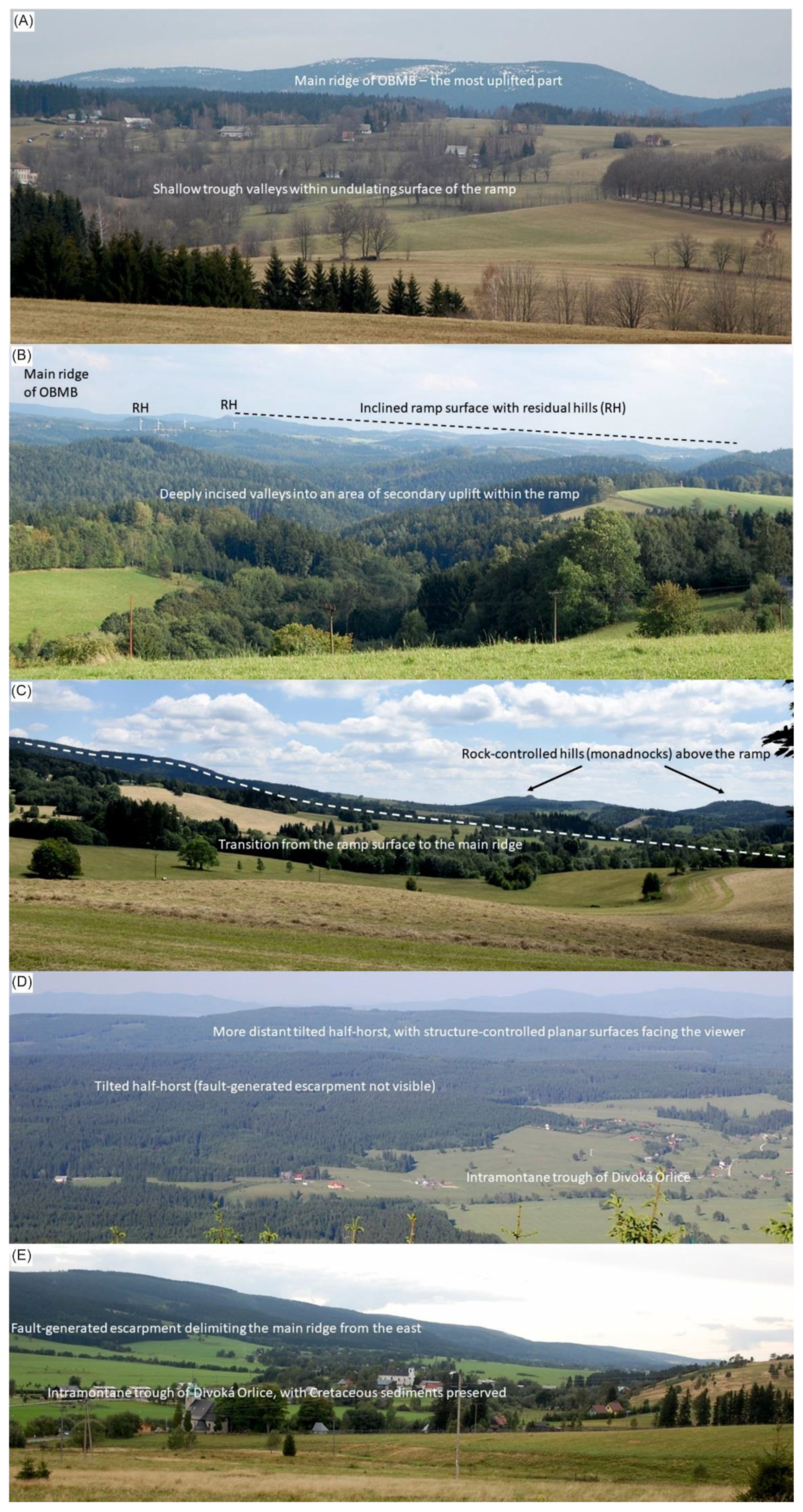
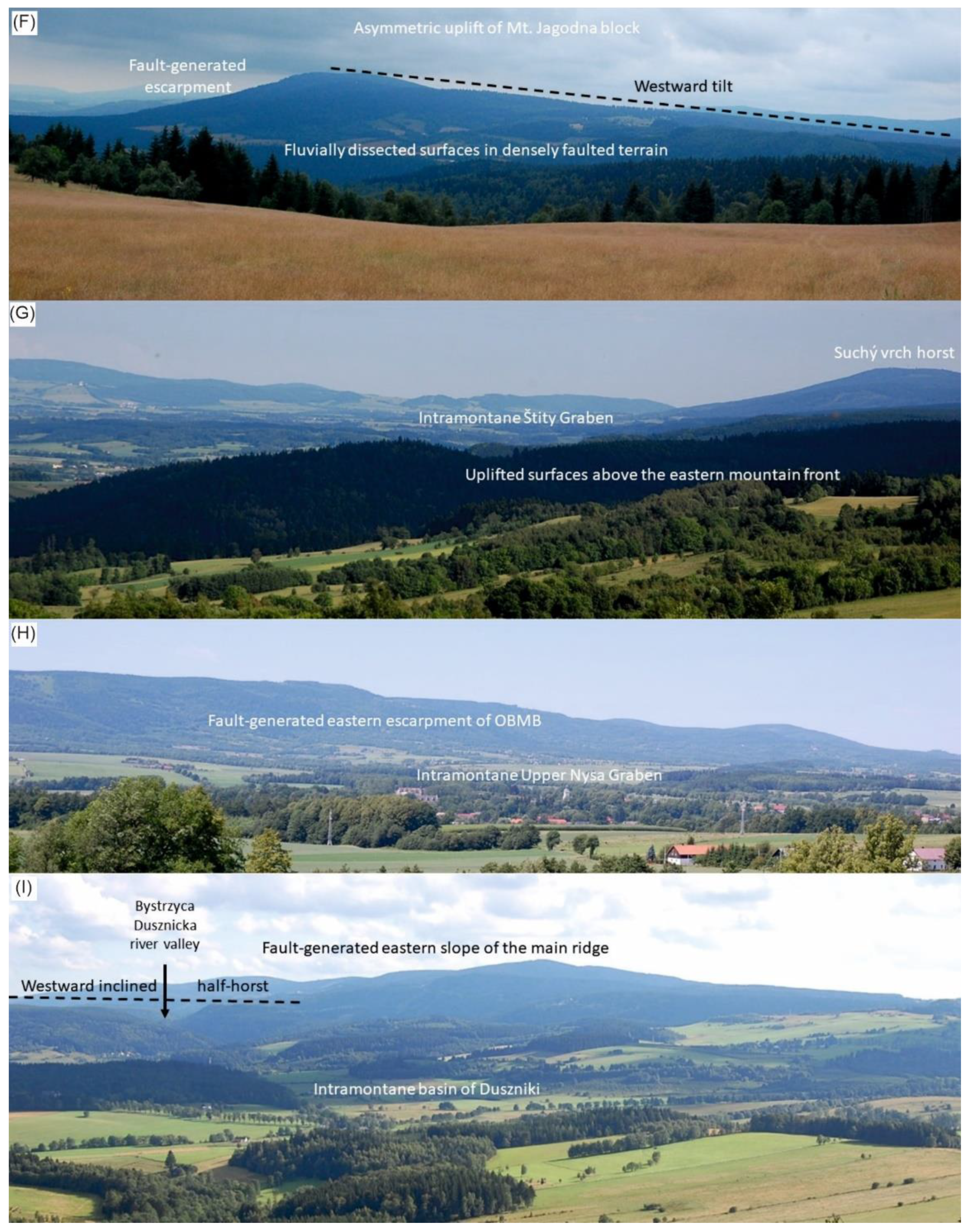
| Letter Code | Locality | Type of Viewpoint | Brief Description of View | |
|---|---|---|---|---|
| Foreground | Background | |||
| Western Part | ||||
| A | Liberk | Open terrain | Shallow trough valleys within undulating surface of the ramp | Main ridge of the Orlické–Bystrzyckie Mountains Block (OBMB)—the most uplifted part |
| B | Dobrošov | Viewing tower | Deeply incised valleys into an area of secondary uplift within the ramp | Inclined ramp surface with residual hills; main ridge of OBMB in the far left |
| C | Polom | Open terrain | Transition from the ramp surface to the main ridge—evidence of increasing uplift | Rock-controlled hills (monadnocks) rising above the ramp |
| Axial Part | ||||
| D | Velká Deštná | Viewing tower | Tilted half-horst (fault-generated escarpment not visible) and intramontane trough of Divoká Orlice | More distant tilted half-horst, with structure-controlled planar surfaces facing the viewer |
| E | Mostowice | Open terrain | Intramontane trough of Divoká Orlice, with Cretaceous sediments preserved | Fault-generated escarpment delimiting the main ridge of OBMB from the east |
| Not coded | Suchý vrch | Viewing tower | Axial part of the main ridge (southernmost part) | Asymmetric uplift of Suchý vrch block, fault-generated escarpment in the east (left), westward tilt |
| Eastern Part | ||||
| F | Huta | Open terrain | Fluvially dissected surfaces in densely faulted terrain | Asymmetric uplift of Mt. Jagodna block, fault-generated escarpment in the east (left), westward tilt |
| G | Jedlnik | Open terrain | Uplifted surfaces above the eastern mountain front | Intramontane Štity Graben (middle) and Suchý vrch horst (right) |
| H | Mielnik * | Open terrain | Intramontane Upper Nysa Graben | Fault-generated eastern escarpment of OBMB |
| Northern Part | ||||
| I | Skały Puchacza * | Open terrain | Northern foreland of OBMB (intramontane basin of Duszniki) | Westward inclined half-horst, incised by Bystrzyca Dusznicka river, with structure-controlled planar surfaces (left), and fault-generated eastern slope of the main ridge. |
Publisher’s Note: MDPI stays neutral with regard to jurisdictional claims in published maps and institutional affiliations. |
© 2021 by the authors. Licensee MDPI, Basel, Switzerland. This article is an open access article distributed under the terms and conditions of the Creative Commons Attribution (CC BY) license (http://creativecommons.org/licenses/by/4.0/).
Share and Cite
Migoń, P.; Różycka, M. When Individual Geosites Matter Less—Challenges to Communicate Landscape Evolution of a Complex Morphostructure (Orlické–Bystrzyckie Mountains Block, Czechia/Poland, Central Europe). Geosciences 2021, 11, 100. https://doi.org/10.3390/geosciences11020100
Migoń P, Różycka M. When Individual Geosites Matter Less—Challenges to Communicate Landscape Evolution of a Complex Morphostructure (Orlické–Bystrzyckie Mountains Block, Czechia/Poland, Central Europe). Geosciences. 2021; 11(2):100. https://doi.org/10.3390/geosciences11020100
Chicago/Turabian StyleMigoń, Piotr, and Milena Różycka. 2021. "When Individual Geosites Matter Less—Challenges to Communicate Landscape Evolution of a Complex Morphostructure (Orlické–Bystrzyckie Mountains Block, Czechia/Poland, Central Europe)" Geosciences 11, no. 2: 100. https://doi.org/10.3390/geosciences11020100
APA StyleMigoń, P., & Różycka, M. (2021). When Individual Geosites Matter Less—Challenges to Communicate Landscape Evolution of a Complex Morphostructure (Orlické–Bystrzyckie Mountains Block, Czechia/Poland, Central Europe). Geosciences, 11(2), 100. https://doi.org/10.3390/geosciences11020100