Article

Climate Change Adaptation of Geo-Structures in Europe: Emerging Issues and Future Steps

1
Department of Structural, Building and Geotechnical Engineering, Politecnico di Torino, Corso Duca degli Abruzzi 24, 10129 Torino, Italy
2
Institute of Geotechnics, Department of Civil and Environmental Engineering, Technical University of Darmstadt, Franziska-Braun-Str. 7, 64287 Darmstadt, Germany
3
Faculty of Civil Engineering, Traffic Engineering and Architecture, University of Maribor, Smetanova 17, 2000 Maribor, Slovenia
4
Deltares, Boussinesqweg 1, 2629 HV Delft, The Netherlands
5
Norwegian Geotechnical Institute, P.O. Box 3930, N-0806 Oslo, Norway
6
Geotechnical Department, National Laboratory for Civil Engineering (LNEC), Av. do Brasil, 101, 1700-066 Lisboa, Portugal
7
Soil Mechanics Laboratory, Department of Structures, Technical University of Cluj-Napoca, Strada Memorandumului 28, 400114 Cluj-Napoca, Romania
8
Laboratoire Sols, Roches et Ouvrages Géotechniques, Université Gustave Eiffel, 5 Bd Descartes, 77420 Champs-sur-Marne, France
9
Swedish Geotechnical Institute, SE-581 93 Linköping, Sweden
*
Author to whom correspondence should be addressed.
Geosciences 2021, 11(12), 488; https://doi.org/10.3390/geosciences11120488
Submission received: 3 November 2021 / Revised: 20 November 2021 / Accepted: 24 November 2021 / Published: 29 November 2021
(This article belongs to the Special Issue Climate Change and Geotechnical Engineering)

Abstract

:
Climate change is already being felt in Europe, unequivocally affecting the regions’ geo-structures. Concern over this is rising, as reflected in the increasing number of studies on the subject. However, the majority of these studies focused only on slopes and on a limited geographical scope. In this paper, we attempted to provide a broader picture of potential climate change impacts on the geo-structures in Europe by gathering the collective view of geo-engineers and geo-scientists in several countries, and by considering different geo-structure types. We also investigated how geo-structural concerns are being addressed in national adaptation plans. We found that specific provisions for geo-structural adaptation are generally lacking and mainly come in the form of strategies for specific problems. In this regard, two common strategies are hazard/risk assessment and monitoring, which are mainly implemented in relation to slope stability. We recommend that in future steps, other geo-structures are likewise given attention, particularly those assessed as also potentially significantly affected by climate change. Countries considered in this study are mainly the member countries of the European Large Geotechnical Institutes Platform (ELGIP).

1. Introduction

Climate change is already being felt in Europe. Compared to the pre-industrial level, a general increase in temperature has been observed throughout the region, rising by as much as 1.09 °C from 2011 to 2020 [1]. A changing precipitation pattern that varies in space and time has also been experienced everywhere. Such changes in the climate are expected to intensify in the future, which will undoubtedly have adverse impact on the stability and serviceability of Europe’s geo-structures, such as natural and artificial slopes, embankments, earth dams, levees, dikes, foundations and retaining structures.
As Vardon [2] pointed out, changing climate alters the environmental load on these infrastructures, and therefore their geotechnical performance. In addition to the more known climate change manifestation of a rising sea level, Vardon [2] also identified other factors that are likely to threaten geo-structures: increasing temperature causing excessive soil drying; increasing mean rainfall reducing soil suctions; increasing drought events leading to soil desiccation; increasing intense precipitation causing soil erosion and flooding. Vahedifard et al. [3], focusing on geo-structures in partially saturated conditions, is in agreement with [2], but in addition to altered load conditions, also identified altered soil properties as another effect of climate change that can impact the performance of geo-structures. They listed several processes that can weaken partially saturated earthen structures, resulting primarily from variations in the soil moisture and temperature.
In Europe, the rising concern over the impact of climate change on geo-structures is reflected in the increasing number of studies on the subject in recent years. For instance, in reviewing and analysing the literature on landslide-climate studies published between 1983 and 2016, Gariano et al. [4] found that the majority of the studies come from Europe. They, however, noted, that the geographical distribution of these studies is uneven, with most mainly coming from Italy, France and United Kingdom. An example of such landslide-climate studies is that from [5], which reviewed and illustrated possible changes in the occurrence of debris flows, landslides and rockfalls for selected regions of the Swiss, Italian, and French Alps as a result of predicted increased rainfall and excessively warm air temperature. Another example is that of [6], who estimated the impact of increased precipitation on slope stability in Sweden, finding that reduced safety and more frequent mudflows are to be expected. In addition, some larger-scale studies exist. For instance, within the framework of COST Action TU1202, a coalition that aims to address the challenges of engineered slope resilience in the context of climate change in Europe, Tang et al. [7] presented an overview of those climate- and vegetation-driven processes that are of greatest concern for the said type of geo-structure. They also listed key aspects for design consideration under a changing climate and further gave directions for future research and development by highlighting specific areas of concern for specific European climatic regions. These areas of concern include surface and internal erosion, surface desiccation cracking, freeze–thaw effects, wetting/saturation, and shrink–swell behaviour. Another endeavour worth mentioning is the SafeLand project [8], an integrated collaborative research effort funded by the Seventh Framework Programme for research and technological development of the European Commission. Among the main climate change-related achievements of the project are the model simulations of regional and local climate for selected European regions and, with this, the estimation of the potential changes in landslide hazard and spatial distribution of population at risk in Europe due to climate change. It is worth noting that the majority of the available literature on the impact of climate change on geo-structures is on natural and engineered slopes, as in the preceding examples, far outnumbering those dealing with other geo-structures.
Adaptation represents a fundamental strategy for reducing and managing the risks of climate change impacts on geo-structures and is critical in delineating climate-resilient pathways for the design and management of these structures. Adaptation generally refers to the process of adjusting in response to current or expected climate change and effects, with the aim to reduce exposure and vulnerability to climate variability. The number of scientific publications assessing climate change impacts, vulnerability, and adaptation more than doubled between 2005 and 2010 [9], with adaptation emerging as a core research topic. However, not many publications deal with the geotechnical aspect of climate change adaptation (CCA). This is possibly because geotechnical problems usually require high spatial resolution information on climatic extremes, but model results are often only available at low spatial resolution and/or do not look at the climatic extremes. In this relation, the role of monitoring and early warning is and will be more and more crucial in identifying the response of geo-structures to a changing climate. Some advances in monitoring of geo-structures exposed to climate change are discussed in [10,11] with special reference to the measurement of pore-water tension and water regime for embankments and slopes.
In this paper, we review the present and future climate trends in Europe. Then, we attempt to provide a broader picture of how climate change is expected to affect the geo-structures in the region by gathering the collective view of geo-engineers and geo-scientists in a number of European countries, and by considering a number of geo-structure types. We also look into how geotechnical issues and concerns are being addressed and incorporated in national adaptation plans and programs. Finally, we provide selected examples of how climate change adaptation in relation to geo-structures is being implemented on the ground. The aim is to identify current trends and the way to go forward in securing Europe’s geo-structures against the onslaught of climate change. Countries considered in this study are mainly the member-countries of the European Large Geotechnical Institutes Platform (ELGIP, https://elgip.org/, (accessed on 20 November 2021)).

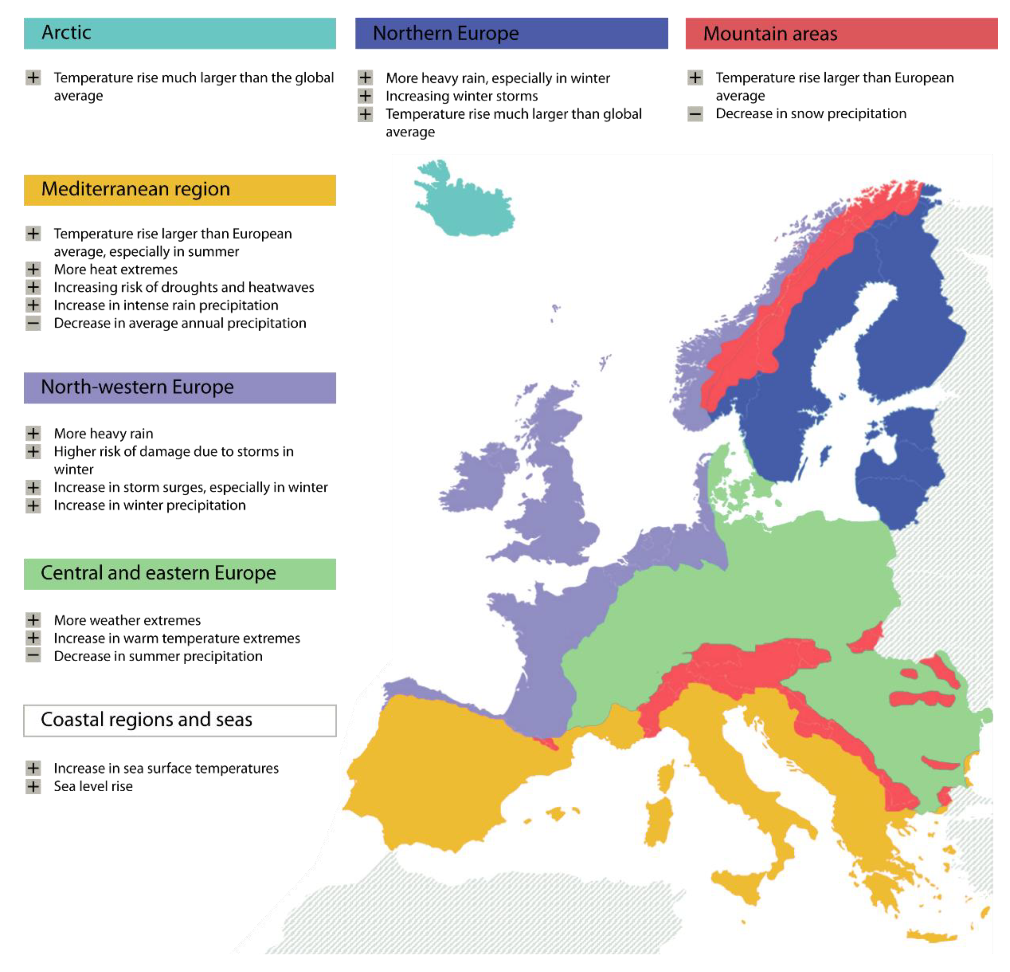
2. Present and Future Climate Trends in Europe

Shifting weather patterns are undoubtedly silently threatening our natural and built environment. Referring to the different climatic regions in Europe shown in Figure 1, clear signs of this pattern shift are as follows:
  • An observed decreasing precipitation trend in parts of southern Europe, particularly in summer, whereas in northern Europe, an increase in annual precipitation of about 70 mm per decade is observed, mostly as winter precipitation [12]. This increase is also the result of more intense precipitation events in western Europe [13].
  • Since 1950, high temperature extremes (e.g., hot days and heat waves) have become more frequent and long-lasting.
  • Droughts phenomena are becoming more intense and frequent in southern Europe. Low temperature extremes (e.g., frost days) have become less frequent [14,15].
  • Since 1850 Alps glaciers have lost about half of their volume and this trend could continue in future [12]. The retreat of Alpine, Scandinavian and Icelandic glaciers is considered a major climate change impact [16].
  • The average sea level has been increasing (3 mm/year in recent decades according to [14]).
  • Storm behaviour throughout Europe is variable in location, frequency and intensity. Frequency showed a general increase over the 1960s to 1990s, after which it decreased to the present [12].
For the future, climate models show a significant temperature increase between 2.5 and 4 °C by 2071–2100 for all emission scenarios for the whole of Europe, with the most substantial warming in eastern and southern Europe during summer and in northern and north-western Europe during winter [12,17,18]. Heatwaves are projected to become more frequent and longer lasting over the 21st century [14], especially in central and eastern Europe.
Modelled future precipitation varies regionally and seasonally. For continental Europe, trends are less clear than in other parts of the region. However, most climate models show a continued increase, mostly in winter precipitation, for northern Europe, whereas it is decreasing for southern Europe, most notably in summer [12,18]. The number of days with high precipitation is projected to increase. Additionally, precipitation is expected to be more rain than snow in mountainous regions [12]. Climate models do not show clear trends in the direction, magnitude, or intensities of storm activity [16]. However, most studies agree that in northern, north-western and central Europe, the risk of severe storms will increase [12].
Projected future global sea level rise is expected to be in the range of 0.29–0.55 m for RCP 2.6 to 0.48–0.82 m for RCP 8.5 [15]. Note that RCP stands for Representative Concentration Pathway, which was used in the Fifth Assessment Report of the Intergovernmental Panel on Climate Change (IPCC) [9] to describe how concentrations of greenhouse gases in the atmosphere will change in future as a result of human activities. The four RCPs considered are RCP2.6 (“climate protection” scenario), RCP4.5 (“medium” scenario), RCP6 (“high” scenario) and RCP8· (“business-as-usual” scenario), labelled after a possible range of radiative forcing values in the year 2100 relative to preindustrial values (+2.6, +4.5, +6.0 and +8.5 W/m2, respectively). Further on, sea level rise, regional changes have low confidence. Extreme analyses derived from the SRES (Special Report on Emissions Scenarios) A1FI scenario (a future world of rapid economic growth with fossil-intensive technologies [19]), with low probability and high impact, show a mean sea level rise between 0.55 and 1.15 m globally and (The Netherlands) between 0.40 to 1.05 m locally by 2100. Extreme, very unlikely scenarios for the UK vary from 0.9 to 1.9 m by 2100 [20].
Extreme events will increase, most notably heat waves, droughts and precipitation events [21,22]. Temperature extremes are expected to increase, resulting in an increased number of warm days, warm nights and heatwaves. Changes in extreme precipitation events vary regionally, with high confidence in increased extreme precipitation in northern Europe (all seasons) and continental Europe (except summer). In southern Europe, projections are seasonally different.
Future extreme storm surges vary along the European coasts, with significant increases in the eastern North Sea and the west of the UK and Ireland, except south of Ireland [13,23]. Meanwhile, projections for the south of the North Sea and the Dutch coast show a stable [24] to increasing trend [12].
Regionally, the combination of observed and projected climate change shows that in Northern Europe, the temperature rise is larger than that globally, resulting in decreasing snow and ice cover, increasing river flows, increasing damage risk from winter storms with increased winter precipitation and risk of river and coastal flooding in North-Western Europe. Central and Eastern Europe show an increase in air temperature extremes, a decrease in summer precipitation, and an increase in water temperature. In the Mediterranean region, the temperature rise is more significant than the European average (especially in summer). In this region, several extreme meteorological events are expected to increase (heatwaves, droughts, intense rain precipitation), accompanied by a decrease in average annual precipitation, decrease in annual river flow, increase in the risk of soil erosion and desertification (especially in southern Italy), as well as in the risk of floods and coastal erosion due to sea level rise and subsidence, both anthropic and natural. The expected climate change signals across European climatic regions are shown in Figure 1.

3. Causal Chain Mapping and Significance Analysis of Climate Change Impacts on Geo-Structures

To identify the most important impacts of climate change from a geotechnical standpoint and, therefore, determine the areas where the geotechnical community should focus its research efforts in the next years, a causal chain mapping and significance analysis was carried out through literature review, expert knowledge and questionnaire-based survey. As a first step to the causal chain mapping, relevant climate change signals were identified, here meant as the manifestations of a changing climate with respect to basic climate parameters, e.g., increased/decreased precipitation, increased temperature, increased wind speed, etc. Then, the effects of these signals on geotechnical or geological processes and properties were assessed. Finally, the impacts of the identified effects on geo-structures were tracked down. Following an initial survey among ELGIP members on the most relevant geo-structures in the context of climate change, the geo-structures were broadly grouped as follows:
  • Slopes, including natural slopes that could affect buildings and infrastructures, and engineered slopes such as road/railway slopes or open pit mines.
  • Embankments, i.e., road embankments, railway embankments, earth dams, dikes and levees.
  • Other engineered structures or structures in general, i.e., foundations (footings, piles and embankment foundations) and retaining structures (as gravity walls, cantilevered walls, anchored walls and geosynthetic reinforced walls).
For the significance analysis, the identified impacts were rated for various European countries, mainly those with representatives in ELGIP, via a rapid questionnaire survey. The questionnaire was distributed among geo-engineers and geo-scientists through the national and professional organizations in these countries. The total number of returned questionnaires is 474. For statistical validity, only those countries which returned 20 questionnaires were considered. Meanwhile, the representative of these countries in the ELGIP Working Group on Climate Change Adaptation (WG-CCA) also independently rated the identified impacts. For both procedures, the rating was made according to the criteria shown in Table 1.
The results of the causal chain and significance analysis are summarised in Table 2. Note that in the scoring, several factors have been considered, including, among others, the level of exposure, vulnerability and adaptation capacity. For instance, with regard to slopes, the Netherlands (NL), being mainly lowlands, has low to very low exposure and thus the mostly low impact rating. Meanwhile, Great Britain (GB) is entirely surrounded by waters, which for the most parts are open seas, explaining the high impact rating with respect to the vulnerability of coastal infrastructure to flooding under a sea-level rise scenario. In comparison, Croatia (HR) lies along the Adriatic Sea, which is more of an elongated bay, and is, therefore, more protected against the effects of sea level rise. Moreover, the Croatian Adriatic coast is mostly rocky and relatively steep. Thus, only a relatively few low-lying parts of the coast are especially vulnerable to sea level rise due to climate change [25].
As can be gleaned in the table, each climate change signal can have multiple effects on geotechnical or geological processes and properties, affecting the ground, underlying soil or rock, groundwater, surface water and vegetation. In turn, these effects can have direct impact on different geo-structures. An individual signal can, therefore, have an impact on one or more geo-structures, but conversely, the same impact can also originate from various signals. Thus, for instance, an increase in duration, frequency and/or intensity of precipitation can lead to a degradation of material strength due to increased saturation and physical weathering, increased mineral dissolution due to increased chemical weathering, increased soil erosion, as well as increased surface runoff, surface and groundwater level and flow. One of the potential impacts of such effects, and therefore the impact of the causal signal, is the instability of slopes. However, this impact can also result from most other climate change signals considered.
In most of the countries considered in this paper, the following climate signals appear to be those expected to have the most significant impact on geo-structures: “increased precipitation”, “decreased precipitation/increased drought periods”, “increased number of intense rain-drought cycle” and “sea level rise”. These signals were rated to have medium to high impact for all the geo-structure groups. On the other hand, “Increased wind speed” and “increased air temperature and periods of warm weather in winter” are generally expected to have lesser impact on these geo-structure groups. Considering only slopes, however, all signals except “increased wind speed” are expected to have a significant impact. Of greatest concern is the slope instability that may result from increased precipitation. As a general summary, the following are the impacts considered to be most relevant for the geo-structures in Europe taking account of all climate change signals: instability of slopes, instability of embankments, instability of other engineered structures, damage/failure of engineered structures from flooding, and overtopping/breaching of dikes and levees.

4. Climate Change Adaptation Framework and Strategies as they Relate to Geo-Structures

The significance analysis described in the previous section has highlighted the major climate-related impacts on the different geo-structural groups and their degree of importance across several European countries. A major challenge now and into the future, therefore, is the resilience enhancement of these geo-structures, particularly those considered highly vulnerable. In this regard, a review of the national CCA plans and programs of various ELGIP member-countries was conducted, mainly focusing on provisions relating to geo-structures, to obtain an overview of how the said challenge is being addressed. Specifically, member-country representatives were asked to identify the following:
  • Strategic documents on CCA such as national adaptation plan and related action plans.
  • Geo-related climate effects and impacts mentioned in these strategic documents.
  • Specified actions.
  • Responsible bodies for action (national, regional or municipal level).
The results of the review are summarised in Table 3, where it emerges that all the countries considered have published (or in the process of approving and publishing, as in the case of Italy) comprehensive national strategies and action plans for climate change adaptation, as recommended by the European Union. In general, such strategies and plans are quite similar to one another and vary only slightly between countries. For instance, they have a similar approach of defining adaptation strategies and risk reduction measures over a broad spectrum of societal sectors and activities. All make reference to climate change effects and impacts relating to geo-structures such as instability of slopes, soil erosion, soil subsidence, flooding and damages to road and rail infrastructures. However, specific strategies for geotechnical CCA are generally lacking. Provisions relevant to geo-structures seem more related to the impacts of climate change on natural hazards (usually floods and landslides) rather than on geotechnical engineering practice and design. It is noted though that in some cases, specific strategies are given for specific challenges, such as the construction/revision of risk and vulnerability maps with respect to rail and road infrastructures, adaptation of technical rules and standards for the design of infrastructures, landslide monitoring and early-warning systems. This is consistent with the suggested strategies of the IPCC [26] for managing climate change risk through adaptation, specifically early warning systems, hazard and vulnerability mapping, improved drainage, adaptation of building codes and practices, and transport and road infrastructure improvements.
Concerning the responsible bodies for actions, it is generally noted that the parliament, the national government and/or specific ministries, such as the Ministry of Infrastructure and Climate in the Netherlands or the Ministry of the Environment and of Energy in Romania, set the legal framework and provide the guidelines to support climate change adaptation initiatives. The development and implementation of specific measures, on the other hand, are under the responsibility of national, provincial and/or municipal governments.

5. Climate Change Adaptation Strategies: Hazard/Risk Assessment and Monitoring

As seen in the preceding section, specific provisions for geotechnical CCA are generally lacking in the national CCA plans and programs of the countries considered in this paper. Instead, they are subsumed under relevant sectoral activities and/or come in the form of specific strategies for specific problems. In this relation, two adaptation strategies that are common and, in fact, have become a standard not only in the countries considered in this paper, but also worldwide, are hazard/risk assessment and monitoring. Hazard/risk assessment allows the identification of the most vulnerable areas and is therefore vital in the formulation of future more detailed investigations, mitigation measures and emergency plans. Meanwhile, hazard/risk monitoring allows prompt actions should the nature, potential impact, or likelihood of the risk go beyond acceptable levels.
Within the context of climate change, it is understandable why the above-mentioned strategies are the most common geo-structure-related CCA measures in many countries. This is because these measures are the most amenable to the application of future climate projections. Due to current limitations in downscaling said climate projections, adaptations are mostly in the form of regional assessments, i.e., projections are too coarse for local implementation, as for example in the adaptive design of specific geo-structure. As such, at the local level, the most reliable protective/adaptive measure at the moment is monitoring and early warning systems (MEWS). In the future, there is a need to consider other adaptation measures including, among others, adaptation of technical rules and standards for the design of infrastructures, as well as innovative nature-based solutions.
In the following, we give examples of these regional hazard/risk assessments and MEWS.

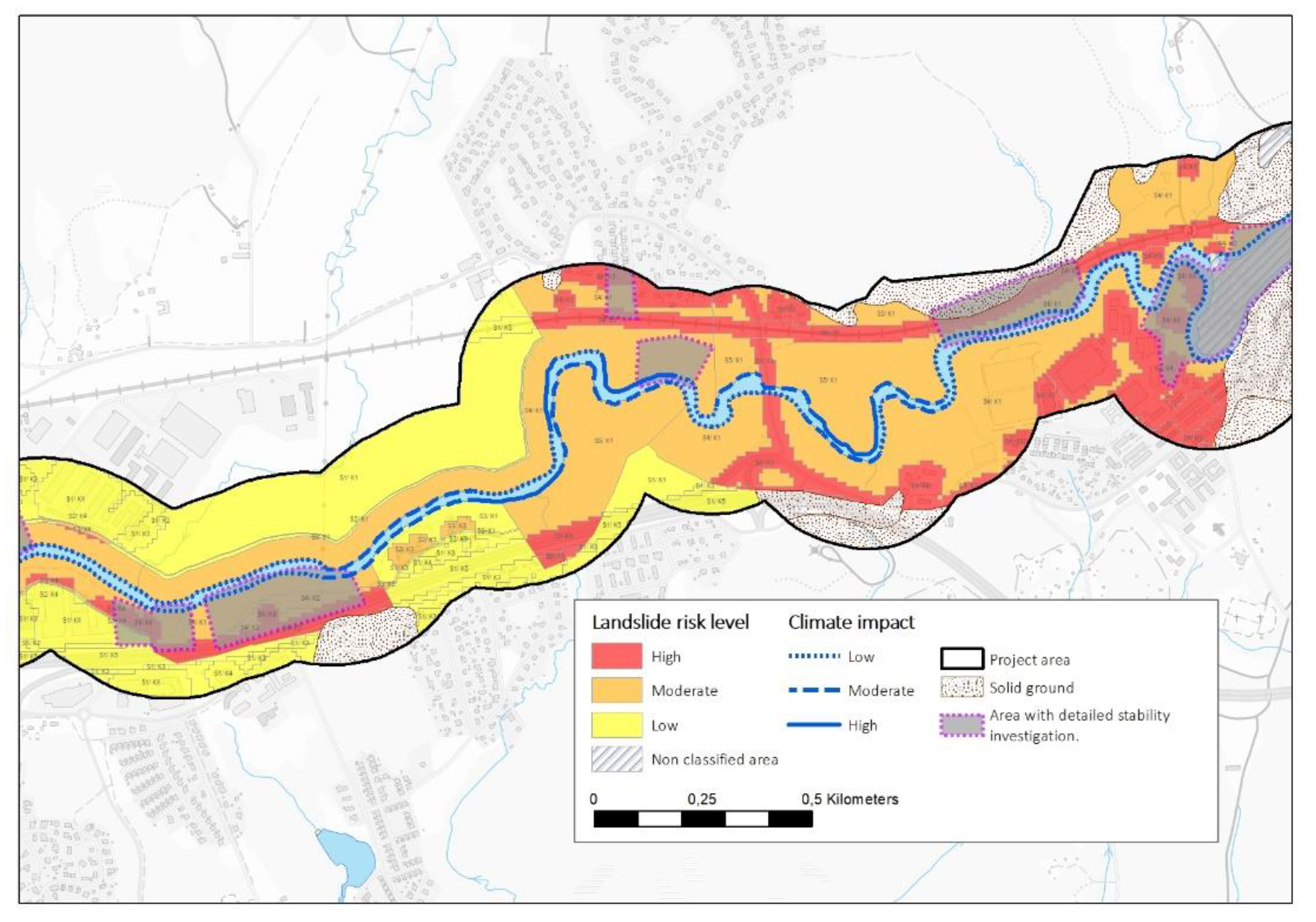
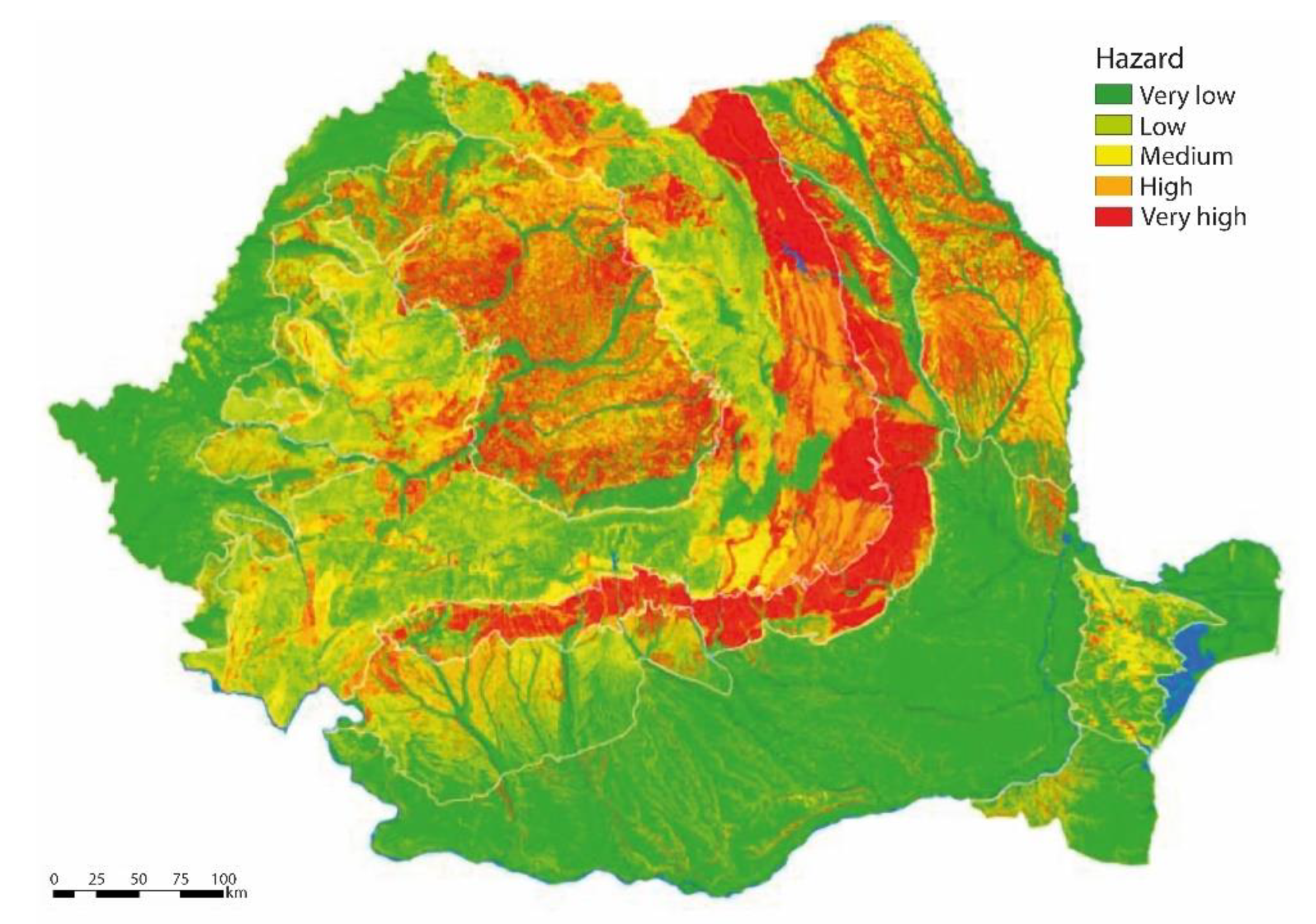
5.1. Hazard/Risk Assessment

Extreme precipitation events, either in the form of rain or snow, are common triggers for many damaging phenomena, as seen in Section 3. Realizing this, the cross-border cooperation project Crossrisk, which covers Slovenia and Austria, was carried out to improve the safety of the population and infrastructure by providing forecasts and warnings for rain, floods and snow. The project results are presented in the Crossrisk website [50], which is updated daily in terms of meteorological parameters for four main areas: Avalanche, Weather & Snow, Hydro and Climate. The set of climate data includes spatial distribution of extreme precipitation and extreme snow load. Extreme precipitation is presented for return periods from 5 up to 250 years for precipitation duration from 5 min up to 120 h. Meanwhile, the extreme snow load is shown for return periods from 5 up to 100 years.
Figure 2 is an example where the spatial pattern of extreme precipitation with return period of 100 years is shown. Detailed information for a selected location can be obtained simply by entering the location coordinates. This information can then be used to make projections for the future. For example, for the location of a landslide with coordinates (46.13108, 15.55915) shown in Figure 2, the information obtained from the Crossrisk map (Columns 2 and 3 in Table 4) was used by [51] to calculate changes in the precipitation level by 2050 due to the increase in temperature (Columns 4–7 in Table 4) using a selected ensemble of regional climate models and applying climate change scenario RCP4.5. The most significant changes are expected during the winter months when, according to projections, precipitation in the lowlands will fall as rain rather than snow. Thus, snow cover as a water reservoir will be a rarer phenomenon than it is today, such that more problems related to large amounts of rain (e.g., flooding and landslides) can be expected [51].
Climate data such as those above are important input data for hazard and risk maps such as those shown in Figure 3 andFigure 4. In Romania, the historical rainfall data was empirically correlated with the historical landslide events under RO-RISK [52], an EU-funded project aimed at identifying evaluating landslide hazard at the national level for better prevention. Precipitation patterns in the country are expected to become more irregular and the frequency of shorter, more intense, localized rainfall events to become higher. The correlation shows that the increase in rainfall quantity will increase the frequency of landslide events and cause the reactivation of existing landslides. The national landslide hazard map based on the expected maximum seasonal precipitation from 2021 to 2050 is illustrated in Figure 3. Such a map allows for localizing the most susceptible areas, where mitigating measures are most needed.
Meanwhile, in Sweden, risk maps are generated by also considering exposed population, assets and environment. Specifically, the Swedish Geotechnical Institute, by order of the Swedish government, was tasked to provide an overall picture of the landslide risks along prioritised watercourses under current and future climate [53,54]. While many areas in the country are susceptible to landslides, areas along watercourses flowing through layers of loose soil are often more vulnerable.
To assess the risk, the investigated area is allocated a probability categorisation and a consequence categorisation, the combination of which determines the risk category. To assess the probability of a landslide, the traditional computation of the factors of safety for slope stability is complemented with the inherent uncertainty in the parameters that have been incorporated. The consequences are then assessed qualitatively for buildings, transport routes and contaminated areas based on four aspects: life, environment, economic impact and societal function.
Due to increased precipitation and temperature projected for Northern Europe (Figure 1), expected climate change effects in areas along watercourses are higher water flow and levels. As a result, increased erosion of the toe of the slopes and riverbeds, as well as higher groundwater levels and pore water pressure, are expected. This will have an impact on the probability of landslide occurrence mainly due to changes in the geometry of riverbank slopes. Such effect on landslide probability is designated ‘sensitivity to climate impact’ and categorised into low, moderate and high.
The results of the landslide risk and climate change impact assessments are presented in maps, which are accessible to external users via a map viewer. An example is shown in Figure 4 for one of the prioritized rivers, the Säveån River. Landslide risk is divided into three categories (low, moderate and high) and the climate impact by 2100 is shown as (solid, dashed or dotted) blue lines along the water course.
Figure 4. Example of risk map for one of the prioritized rivers in Sweden, the Säveån River (modified from [55]).
Geosciences 11 00488 g004
As the changing climatic conditions and the concomitant increase in extreme events can strongly jeopardize the functioning of critical infrastructures such as the transportation system, risk identification can be more targeted, as in the examples from Germany and Netherlands. In Germany, the Federal Ministry of Transport and Digital Infrastructure (BMVI) launched a national research program with the aim to develop fundamental principles for increasing the resilience of the country’s transport system to climate change and extreme events through appropriate adaptation measures. The first phase of the program (2016–2019) was focused on the assessment of climate change effects and impacts on transport infrastructure (e.g., roads, railway embankments). Among the priority areas relevant to the present paper are the impacts of landslides, flooding and storms. According to [56], an additional 1% of the highway and rail networks (about 390 and 370 km, respectively) may be potentially exposed to landslide in the near future (2031–2060) compared to the reference period (1971–2000). The figures increase to about 2–3% if the distant future (2071–2100) is considered. As regards flooding [57], river sections that are already characterized by winter flood events are expected to be increasingly at risk. In particular, future projections show an increase in flood hazards in the Rhine, Danube and their larger tributaries. Nationwide, about 2% of the federal road network and 1% of the rail network are currently located in the floodplain of a “medium flood scenario”, which statistically occurs about every 100 years. Under the “extreme” flood scenario, the potential inundation area covers 8% of both the federal road network and of the rail network (Figure 5a). Meanwhile, Bott et al. [58] describe the results of the analysis of the impact of windstorm, showing that the exposure of the country’s transport infrastructure to windthrow is largely determined by the presence of vegetation. Overall, about 23–25% of the federal highway and rail network run through forested areas and are thus potentially at risk from windthrow (Figure 5b).
Like Germany, the Netherlands also embarked on quantifying the impacts of future climate change and associated weather extremes on the Dutch motorway network, with the ultimate goal of establishing a climate resilient road network by 2050. To attain that objective, Deltares developed and conducted a stress test in close collaboration with the Dutch national road authority (“Climate Proof Networks” project) [59,60]. In the first phase of this test, climate change signals were identified and the corresponding exposure of the motorways and vital elements such as bridges and tunnels was assessed and mapped. Climate change in the Netherlands is typically characterised by drier summers, wetter winters and shorter, intense rainfall events. The stress test, therefore, looked into the related climate change effects, such as river and coastal flooding due to intense rainfall, and to subsequent climate change impacts, among which dike breaches, instability of embankments (Figure 6) and road deformation caused by soil subsidence were identified. In the second phase, the vulnerability of the motorways was calculated, assessing the damage and recovery costs, as well as the cascade effects in terms of losses due to delays incurred by road users because of partial or full obstruction of the motorway. The outcomes are being used by the Dutch national road authority to evaluate the risks of disruptive events, identify effective measures, improve the climate resilience of future motorway network structures and produce dedicated information packages for the districts, asset managers, governance and road specialists.

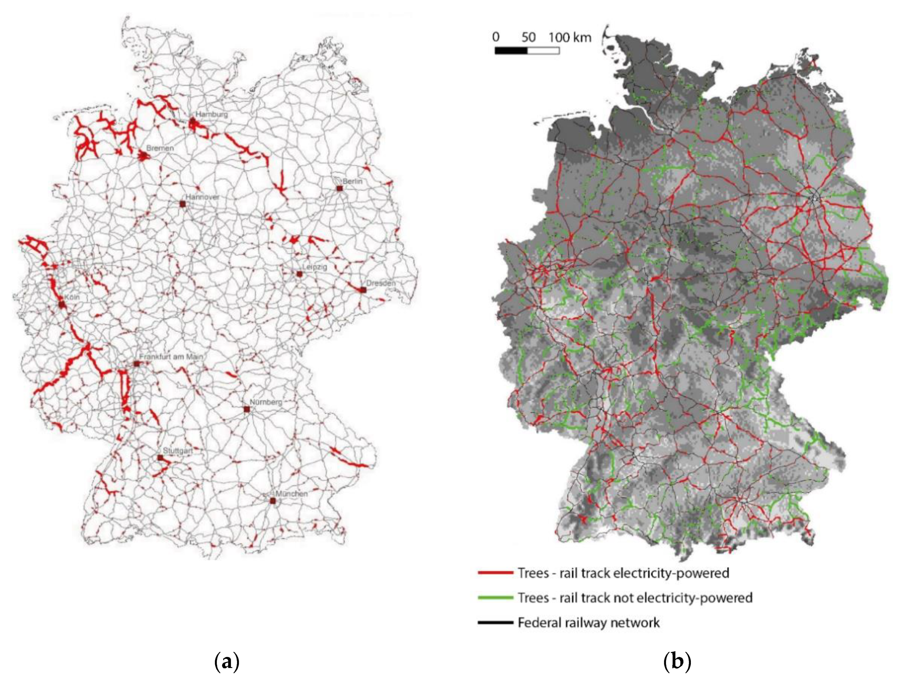
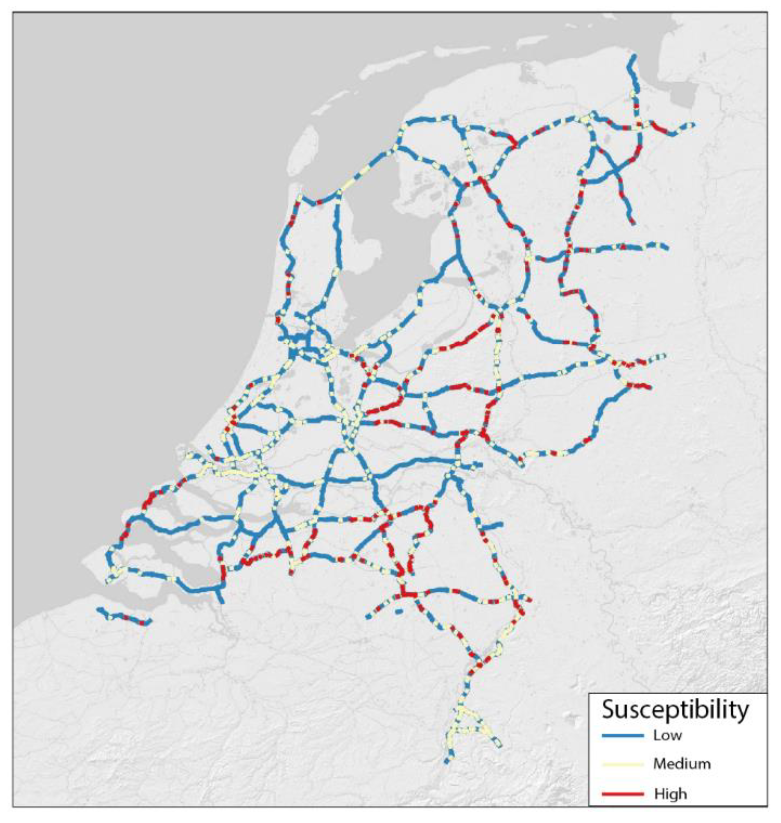
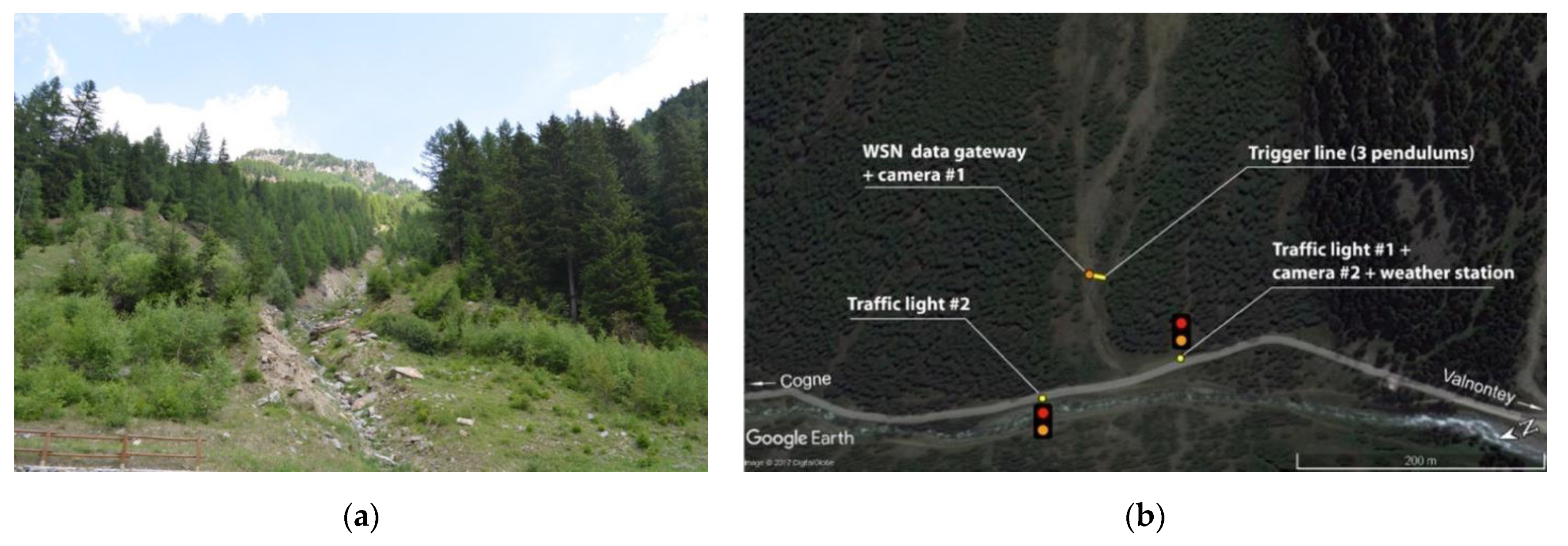
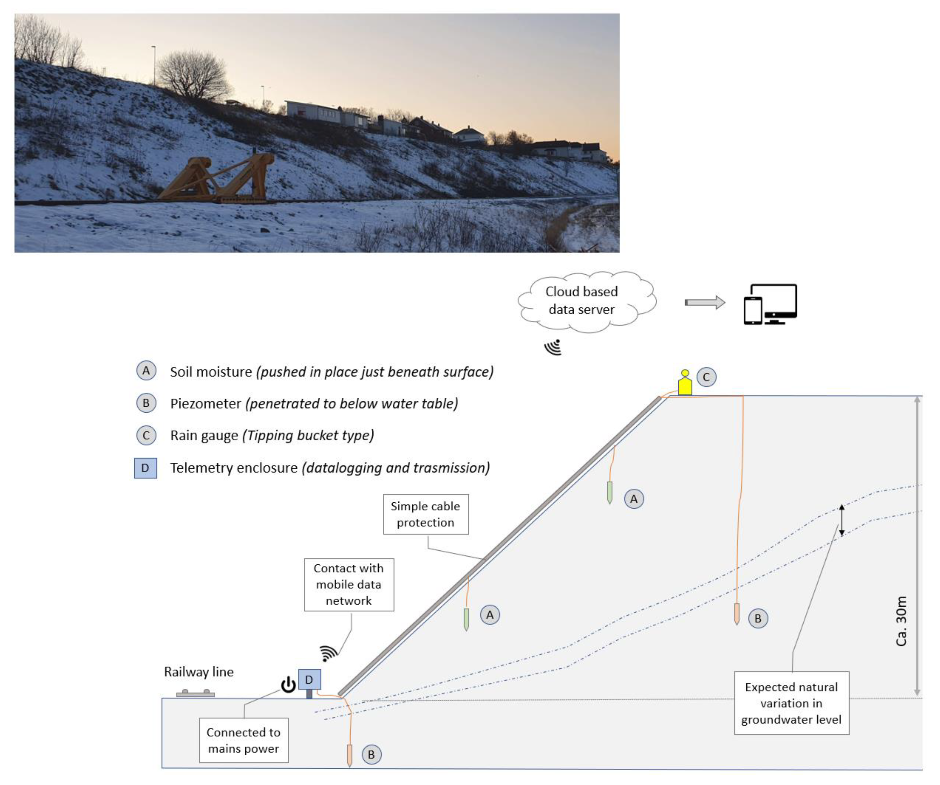
5.2. Hazard/Risk Monitoring

The protection of infrastructures against natural hazards and the need for increasing their resilience become increasingly relevant in view of the climatic threats, as seen above. In this relation, monitoring and detection systems can play a crucial role, as for example with regard to debris flow and snow avalanches, which is an issue of growing importance in mountain environment [61]. Monitoring and early warning systems are reliable adaptation strategies which can either be combined with structural measures or a standalone cost-saving alternative in less densely urbanized areas. The low implementation and maintenance costs, as well as the limited impacts on the environment, are among their main advantages. It must however be noted that regardless of the sensor used and the measured parameter, the MEWS must be robust and redundant. Moreover, they must be able to automatically generate warning and execute specific actions when specific conditions are met.
Figure 7 shows an example of such kind of systems and applications in the North-Western Italian Alps (1630 m a.s.l. altitude) to protect a mountain road against debris flows and snow avalanches that occur periodically along a gully [62]. The system is straightforward and low cost. It is based on a detection section (i.e., trigger line) equipped with inclinometers suspended above the gully located approximately 120 m upstream from the road. Other equipment includes traffic lights, a weather station and cameras. A wireless sensor network [63] is used to manage the system so that all sensors and equipment can communicate through radio signals without the need for cables. When the detection section is triggered directly by the passage of the debris or the avalanche, an alarm is generated and transmitted to turn on the traffic lights on the road.
MEWS are also being experimented with in Norway, where large parts of existing rail networks have challenges related to water-related landslides. Potential landslide events at these locations are unlikely to be prevented in the short term—solving these issues will require time and significant costs. However, typical “hot spots” may be managed by improving drainage, or by implementing warning systems. Such a “hot spot” with steep slopes alongside the railway is located at Bodø central station in northern Norway (Figure 8). In this area, the slope has experienced several slides over the years. As such, a pilot project has been initiated to test the possibility of warning for increased danger of landslides based on instrumentation and physical modelling of the stability conditions.
In the pilot project, a simple instrumentation was planned for pore pressure, precipitation, soil moisture and temperature measurements in selected cross sections of the long slope that runs parallel to the rail line with its final leg in the Bodø central station (see Figure 8). The purpose of the system is to monitor parameters associated with slope stability influenced by local rainfall, of which the most important are (a) variations in the level of the groundwater level, (b) changes in moisture content in the upper soil layers and (c) amount and intensity of local rainfall. In addition to monitoring techniques, the pilot project will include testing innovative mitigation methods to reduce the landslide risk, primarily by improving the drainage situation. The test measures include standard drainage systems, a nature-based solution (NBS) using vegetation, as well as a few innovative measures developed by partners in the Klima 2050 consortium [64].

6. Summary and Conclusions

Results of our literature review show that in Europe, as in most parts of the world, studies on climate change impacts on geo-structures are mostly focused on slopes and concentrated in a limited number of areas/countries. Thus, to have a broader picture of the issue, we gathered in this study the collective view of geo-engineers and geo-scientists in several countries through a questionnaire-based survey, considering different geo-structure types. We also reviewed national plans and strategies for relevant provisions on geo-structures, as well as look for relevant actions on the ground. Below, we highlight the main results of this study:
  • In most of the countries considered, the climate signals that appear to have the most significant impact on geo-structures are “increased precipitation”, “decreased precipitation/increased drought periods”, “increased number of intense rain-drought cycles” and “sea level rise”. On the other hand, “increased wind speed’ and “increased air temperature and periods of warm weather in winter” are generally expected to have a lesser impact.
  • The impacts considered to be most relevant for the geo-structures in Europe are the instability of slopes, embankments and other engineered structures; the damage/failure of engineered structures from flooding; and overtopping/breaching of dikes and levees.
  • Specific provisions for geotechnical climate change adaptation are generally lacking in the national plans and programs of the countries considered in this paper and mainly come in the form of strategies for specific problems, e.g., reduction in risks related to a specific hazard.
  • Two adaptation strategies that are common and have become a standard for many countries are hazard/risk assessment and monitoring. Implementation of the said strategies is mainly in relation to slope stability. This is in line with the survey results, where slope instability is considered the most significant impact of climate change in most countries. This is also consistent with the finding that the majority of available literature on the impact of climate change on geo-structures are on natural and engineered slopes, far outnumbering those dealing with other geo-structures.
For future steps, while ensuring the stability of our slopes is of critical importance, it is necessary that the other geo-structures are likewise given attention, particularly those that were assessed to be also potentially significantly affected by climate change. Moreover, implementation and/or strengthening of other measures such as adaptation of technical rules and standards for the design of infrastructures, as well as innovative nature-based solutions, will also be needed if we are to protect our geo-structures more effectively against the onslaught of climate change.

Author Contributions

Conceptualization, A.I., M.A.B.-E., M.B.; methodology, A.I., M.A.B.-E., M.B., H.Z., B.Ž., M.v.M., B.K., T.B., C.P., I.P., F.S., H.L.; formal analysis, A.I., M.A.B.-E., M.B., B.Ž., T.B.; investigation, A.I., M.A.B.-E., M.B., H.Z., B.Ž., M.v.M., B.K., T.B., C.P., I.P., F.S., H.L.; data curation, A.I.; writing—original draft preparation, A.I., M.A.B.-E., M.B.; writing—review and editing, A.I., M.A.B.-E., M.B., H.Z., B.Ž., M.v.M., B.K., T.B., C.P., I.P., F.S., H.L.; visualization, A.I., T.B., B.Ž., H.L., I.P., M.A.B.-E., H.Z., M.v.M., M.B., B.K.; supervision, H.L.; project administration, H.L. All authors have read and agreed to the published version of the manuscript.

Funding

Except for the meeting travel fund provided by ELGIP, this research received no other external funding.

Data Availability Statement

Supporting data are available upon request.

Acknowledgments

The review work described in this paper is a collaborative effort of the ELGIP-Working Group on Climate Change Adaptation (WG-CCA), coordinated by H.L. The Authors are thankful to all the geo experts that contributed to the survey providing their independent opinions and to ELGIP, who supported meeting travel costs for the members of the group.

Conflicts of Interest

The authors declare no conflict of interest.

References

  1. IPCC. Summary for Policymakers. In Climate Change 2021: The Physical Science Basis. Contribution of Working Group I to the Sixth Assessment Report of the Intergovernmental Panel on Climate Change; Masson-Delmotte, V., Zhai, P., Pirani, A., Connors, S.L., Peéan, C., Berger, S., Caud, N., Chen, Y., Goldfarb, L., Gomis, M.I., et al., Eds.; Cambridge University Press: Cambridge, UK, 2021; in press. [Google Scholar]
  2. Vardon, P.J. Climatic influence on geotechnical infrastructure: A review. Environ. Geotech. 2015, 2, 166–174. [Google Scholar] [CrossRef]
  3. Vahedifard, F.; Williams, J.M.; AghaKouchak, A. Geotechnical Engineering in the Face of Climate Change: Role of Multi-Physics Processes in Partially Saturated Soils. In Proceedings of the IFCEE 2018: Advances in Geomaterial Modeling and Site Characterization, Orlando, FL, USA, 5–10 March 2018; Stuedlein, A.W., Lemnitzer, A., Suleiman, M.T., Eds.; pp. 353–364. [Google Scholar]
  4. Gariano, S.L.; Guzzetti, F. Landlides in a changing climate. Earth Sci. Rev. 2016, 162, 227–252. [Google Scholar] [CrossRef] [Green Version]
  5. Stoffel, M.; Tiranti, D.; Higgel, C. Climate change impacts on mass movement–Case studies from the European Alps. Sci. Total Environ. 2014, 493, 1255–1266. [Google Scholar] [CrossRef] [PubMed]
  6. Andersson-Sköld, Y.; Hultén, C.; Rankka, K.; Nilsson, G.; Rydell, B.; Lind, B.; Ottosson, E.; Rosqvist, H.; Starzec, P. Geotechnical approaches to climate change adaptation. WIT Trans. Ecol. Environ. 2006, 86, 429–438. [Google Scholar] [CrossRef] [Green Version]
  7. Tang, A.M.; Hughes, P.N.; Dijkstra, T.A.; Askarinejad, A.; Brenčič, M.; Cui, Y.J.; Diez, J.J.; Firgi, T.; Gajewska, B.; Gentile, F.; et al. Atmosphere–vegetation–soil interactions in a climate change context; impact of changing conditions on engineered transport infrastructure slopes in Europe. Quart. J. Eng. Geol. Hydrogeol. 2018, 51, 156–168. [Google Scholar] [CrossRef]
  8. Nadim, F.; Kalsnes, B.; Solheim, A. Plenary: Progress of living with landslide risk in Europe. In Landslide Science for a Safer Geoenvironment; Sassa, K., Canuti, P., Yin, Y., Eds.; Springer: Cham, Switzerland, 2014; pp. 3–20. [Google Scholar] [CrossRef]
  9. IPCC. Climate Change 2014: Impacts, Adaptation, and Vulnerability; Working Group II Contribution to the IPCC 5th Assessment Report 4; IPCC: Geneva, Switzerland, 2014. [Google Scholar]
  10. Tarantino, A.; Gallipoli, D.; Jommi, C.; Mendes, J.; Capotosto, A.; Amabile, A.; Pedrotti, M.; Pozzato, A.; Beneš, V.; Bottaro, F.; et al. Advances in the monitoring of geo-structure subjected to climate loading. In Proceedings of the 3rd European Conference on Unsaturated Soils–“E-UNSAT 2016”, Paris, France, 12–14 September 2016. [Google Scholar]
  11. Hughes, P.N.; Hen-Jones, R.; Stirling, R.A.; Glendinnning, S.; Gunn, D.A.; Chambers, J.E.; Dijkstra, T.A.; Smethurst, J.; Flesjo, K. Challenges in monitoring and managing engineered slopes in a changing climate. In Proceedings of the 3rd European Conference on Unsaturated Soils–“E-UNSAT 2016”, Paris, France, 12–14 September 2016. [Google Scholar]
  12. EEA (European Environment Agency). Climate Change, Impacts and Vulnerability in Europe 2016; An indicator-based report. EEA Report No. 1/2017; EEA: Copenhagen, Denmark, 2017; pp. 1–304.
  13. IPCC. Managing the Risks of Extreme Events and Disasters to Advance Climate Change Adaptation; A Special Report of Working Groups I and II of the Intergovernmental Panel on Climate Change; Cambridge University Press: Cambridge, UK; New York, NY, USA, 2012; pp. 1–582. [Google Scholar]
  14. EEA (European Environment Agency). Climate Change, Impacts and Vulnerability in Europe 2012; An indicator-based report. EEA Report No. 12/2012; EEA: Copenhagen, Denmark, 2012; pp. 1–304.
  15. Kovats, R.S.; Valentini, R.; Bouwer, L.M.; Georgopoulou, E.; Jacob, D.; Martin, E.; Rounsevell, M.; Soussana, J.F. Europe. In Climate Change 2014: Impacts, Adaptation, and Vulnerability. Part B: Regional Aspects. Contribution of Working Group II to the Fifth Assessment Report of the Intergovernmental Panel on Climate Change; Cambridge University Press: Cambridge, UK; New York, NY, USA, 2014; pp. 1267–1326. [Google Scholar]
  16. IPCC. Climate Change 2014: Synthesis Report; Contribution of Working Groups I, II and III to the Fifth Assessment Report of the Intergovernmental Panel on Climate Change; Pachauri, R.K., Meyer, L.A., Eds.; IPCC: Geneva, Switzerland, 2014; pp. 1–151. [Google Scholar]
  17. Goodess, C.; Jacob, D.; Déqué, M.; Guttiérrez, J.; Huth, R.; Kendon, E.; Leckebusch, G.; Lorenz, P.; Pavan, V. Downscaling methods, data and tools for input to impacts assessments. In ENSEMBLES: Climate Change and Its Impacts: Summary of Research and Results from the ENSEMBLES Project; van der Linden, P., et al., Eds.; Met Office Hadley Centre: Exeter, UK, 2009; pp. 59–78. [Google Scholar]
  18. Kjellström, E.; Nikulin, G.; Hansson, U.; Strandberg, G.; Ullerstig, A. 21st century changes in the European climate: Uncertainties derived from an ensemble of regional climate model simulations. Tellus 2011, 63A, 24–40. [Google Scholar] [CrossRef] [Green Version]
  19. IPCC. Annex II: Climate System Scenario Tables. In Climate Change 2013: The Physical Science Basis. Contribution of Working Group I to the Fifth Assessment Report of the Intergovernmental Panel on Climate Change; Stocker, T.F., Qin, D., Plattner, G.K., Tignor, M., Allen, S.K., Boschung, J., Nauels, A., Xia, Y., Bex, V., Midgley, P.M., Eds.; Cambridge University Press: Cambridge, UK; New York, NY, USA, 2013. [Google Scholar]
  20. Lowe, J.A.; Howard, T.P.; Pardaens, A.; Tinker, J.; Holt, J.; Wakelin, S.; Milne, G.; Leake, J.; Wolf, J.; Horsburgh, K.; et al. UK Climate Projections Science Report: Marine and Coastal Projections; Met Office Hadley Centre: Exeter, UK, 2009; pp. 1–97.
  21. Beniston, M.; Stephenson, D.B.; Christensen, O.B.; Ferro, C.A.T.; Frei, C.; Goyette, S.; Halsnaes, K.; Holt, T.; Jylhä, K.; Koffi, B.; et al. Future extreme events in European climate: An exploration of regional climate model projections. Clim. Chang. 2007, 81 (Suppl. 1), 71–95. [Google Scholar] [CrossRef] [Green Version]
  22. Lenderink, G.; Van Meijgaard, E. Increase in hourly precipitation extremes beyond expectations from temperature changes. Nat. Geosci. 2008, 1, 511–514. [Google Scholar] [CrossRef]
  23. Debernard, J.B.; Røed, L.P. Future wind, wave and storm surge climate in the Northern Seas: A revisit. Tellus 2008, 60, 427–438. [Google Scholar] [CrossRef] [Green Version]
  24. Sterl, A.; van den Brink, H.; de Vries, H.; Haarsma, R.; van Meijgaard, E. An ensemble study of extreme storm surge related water levels in the North Sea in a changing climate. Ocean Sci. 2009, 5, 369–378. [Google Scholar] [CrossRef] [Green Version]
  25. Republic of Croatia, Ministry of Environmental Protection, Physical Planning and Construction. Second, Third and Fourth National Communication of the Republic of Croatia under the United Nations Framework Convention on Climate Change; Ministry of Environmental Protection, Physical Planning and Construction: Zagreb, Croatia, 2006; 107p.
  26. IPCC. Climate Change 2014–Synthesis Report–Summary for Policymakers; IPCC: Geneva, Switzerland, 2014. [Google Scholar]
  27. Observatoire National Sur Les Effets du Réchauffement Climatiques. Stratégie Nationale D’adaptation Au Changement Climatique; La Documentation française: Paris, France, 2007; p. 95. Available online: https://www.ecologie.gouv.fr/sites/default/files/ONERC_Rapport_2006_Strategie_Nationale_WEB.pdf (accessed on 1 November 2021).
  28. Ministère de l’Ecologie, du Développement durable, des Transports et du Logement. Plan National D’adaptation de la France Aux Effets du Changement Climatique; 2011; p. 188. Available online: https://www.ecologie.gouv.fr/sites/default/files/ONERC_PNACC_1_complet.pdf (accessed on 1 November 2021).
  29. Ministère de la Transition Ecologique et Solidaire. Le Plan national D’adaptation au Changement Climatique (PNACC 2); 2017; p. 24. Available online: https://www.ecologie.gouv.fr/sites/default/files/2018.12.20_PNACC2.pdf (accessed on 1 November 2021).
  30. Die Bundesregierung. Deutsche Anpassungsstrategie an den Klimawandel; Die Bundesregierung: Berlin, Germany, 2008; 78p.
  31. Die Bundesregierung. Aktionsplan Anpassung der Deutschen Anpassungsstrategie an den Klimawandel; Die Bundesregierung: Berlin, Germany, 2011; 93p.
  32. Die Bundesregierung. Fortschrittsbericht zur Deutschen Anpassungsstrategie an den Klimawandel; Die Bundesregierung: Berlin, Germany, 2015; 275p.
  33. Die Bundesregierung. Zweiter Fortschrittsbericht zur Deutschen Anpassungsstrategie an den Klimawandel; Die Bundesregierung: Berlin, Germany, 2020; 127p.
  34. Ministero dell’Ambiente e della Tutela del Territorio e del Mare. Strategia Nazionale di Adattamento ai Cambiamenti Climatici; Ministero dell’Ambiente e della Tutela del Territorio e del Mare: Roma, Italy, 2015; 197p.
  35. Ministero dell’Ambiente e della Tutela del Territorio e del Mare. Piano Nazionale di Adattamento ai Cambiamenti Climatici, Giugno 2018 (under Approval); Ministero dell’Ambiente e della Tutela del Territorio e del Mare: Roma, Italy, 2018; 336p.
  36. Castellari, S.; Venturini, S.; Ballarin Denti, A.; Bigano, A.; Bindi, M.; Bosello, F.; Carrera, L.; Chiriacò, M.V.; Danovaro, R.; Desiato, F.; et al. Rapporto Sullo Stato delle Conoscenze Scientifiche su Impatti, Vulnerabilità ed Adattamento ai Cambiamenti Climatici in Italia; Ministero dell’Ambiente e della Tutela del Territorio e del Mare: Roma, Italy, 2014; 878p.
  37. Meijs, S.; Arbouw, G.; de Graaff, R.; van Helden-Solleveld, T.; Helmer, M.; van Hemert, P.; Hoorn, M.; van Nieuwaal, K.; Schoute, E.; Thijssen, M.; et al. Uitvoeringsprogramma 2018-2019 Nationale Klimaatadaptatiestrategie (NAS); Ministerie van Infrastructuur en Waterstaat: The Hague, The Netherlands, 2018; 44p.
  38. Ministerie van Infrstructuur en Waterstaat, Ministerie van Landbouw Natuur en Voedselkwaliteit, Ministerie van Binnenlandse Zaken en Koninkrijksrelaties. Deltaprogramma 2020; Ministerie van Infrstructuur en Waterstaat, Ministerie van Landbouw Natuur en Voedselkwaliteit, Ministerie van Binnenlandse Zaken en Koninkrijksrelaties: Amsterdam, The Netherlands, 2019; 112p.
  39. Norwegian Ministry of Climate and Environment. Climate change adaptation in Norway, Meld. St. 33 (2012-2013). Report to the Storting (White Paper); Norwegian Ministry of Climate and Environment: Oslo, Norway, 2013; 108p.
  40. Presidência do Conselho de Ministros. Resolução do Conselho de Ministros n.º 56/2015; 2015; 55p. Available online: https://dre.pt/dre/detalhe/resolucao-conselho-ministros/56-2015-69905665 (accessed on 25 November 2021).
  41. Presidência do Conselho de Ministros. Resolução do Conselho de Ministros n.º 130/2019; 2019; 36p. Available online: https://dre.tretas.org/dre/3808636/resolucao-do-conselho-de-ministros-130-2019-de-2-de-agosto (accessed on 25 November 2021).
  42. Ministerul Mediului Şi Schimbărilor Climatice. Strategia Naţională a României Privind Schimbările Climatice 2013–2020; Ministerul Mediului Şi Schimbărilor Climatice: Bucureşti, Romania, 2013; 74p.
  43. Ghid Privind Adaptarea la Efectele Schimbărilor Climatice. 2008, p. 40. Available online: https://www.meteoromania.ro/anm/images/clima/SSCGhidASC.pdf (accessed on 1 November 2021).
  44. Resolution on the Long-Term Climate Strategy of Slovenia until 2050; Official Gazette of the Republic of Slovenia. 2021, p. 98. Available online: https://unfccc.int/sites/default/files/resource/LTS1_SLOVENIA_EN.pdf (accessed on 1 November 2021).
  45. Integrated National Energy and Climate Plan of the Republic of Slovenia. 2020. Available online: https://ec.europa.eu/energy/sites/default/files/documents/si_final_necp_main_en.pdf (accessed on 1 November 2021).
  46. Vrčko, M.; Pelko, N.; Jurman, D. Resolution on the National Programme for the Development of Transport in the Republic of Slovenia until 2030; Ministry of Infrastructure: Ljubljana, Slovenia, 2017. Available online: https://www.dlib.si/?URN=URN:NBN:SI:DOC-QJ1BRRJ7 (accessed on 1 November 2021).
  47. Resolution on the National Environmental Action Programme 2020–2030. Republic of Slovenia. 2021. Available online: https://www.gov.si/assets/ministrstva/MOP/Dokumenti/ReNPVO2020_2030_ang.doc (accessed on 1 November 2021).
  48. The Swedish Government, Ministry of the Environment. Regeringens Proposition 2017/18:163–Nationell Strategi för Klimatanpassning; The Swedish Government: Stockholm, Sweden, 2017; 98p.
  49. The Swedish Government, Ministry of the Environment. SFS 2018:1428 Förordning om Myndigheters Klimatanpassningsarbete; The Swedish Government: Stockholm, Sweden, 2018; 3p.
  50. Crossrisk. Available online: https://www.crossrisk.eu/en/ (accessed on 16 October 2021).
  51. Medved, A. Evaluation of Changes in Precipitation in the Surroundings of the Settlement Virštanj; ARSO: Ljubljana, Slovenia, 2021. (In Slovenian)
  52. RO-RISK-Disaster Risk Assessment at National Level-Project Co-Financed by the European Social Fund through the Operational Programme Administrative Capacity-Code SIPOCA 30. 2017. Available online: https://www.researchgate.net/project/DISASTER-RISKS-RESEARCH-AND-ASSESSMENT-AT-NATIONAL-LEVEL-Project-co-financed-by-the-European-Social-Fund-through-the-Operational-Programme-Administrative-Capacity-SIPOCA-30 (accessed on 25 November 2021).
  53. Swedish Geotechnical Institute (SGI). Landslide Risks in a Changing Climate–Säveån River Valley, Part 1: Map Report and Summary of Results; Publication 38–1E: Linköping, Sweden, 2017. [Google Scholar]
  54. Odén, K.; Bergdahl, K.; Löfroth, H.; Göransson, G.; Jönsson, Å.; Kiilsgaard, R.; Öberg, M. Mapping of Landslide Risks in a Changing Climate – Development of Simplified Methodology. In Landslides in Sensitive Clays, Advances in Natural and Technological Hazards Research 46; Thakur, V., Ed.; Springer International Publishing AG: Berlin/Heidelberg, Germany, 2017; pp. 571–580. [Google Scholar]
  55. Swedish Geotechnical Institute (SGI). Available online: http://www.sgi.se/ (accessed on 1 November 2021).
  56. Lohrengel, A.F.; Brendel, C.; Herrmann, C.; Kirsten, J.; Forbriger, M.; Klose, M.; Stube, K. Klimawirkungsanalyse des Bundesverkehrssystems im Kontext gravitativer Massenbewegungen-Schlussbericht des Schwerpunktthemas Hangrutschungen (SP-105) im Themenfeld 1 des BMVI-Expertennetzwerks. 2020, p. 47. Available online: https://www.bmvi-expertennetzwerk.de/DE/Publikationen/TFSPTBerichte/SPT105.html (accessed on 25 November 2021). (In German). [CrossRef]
  57. Rauthe, M.; Brendel, C.; Helms., M.; Lohrengel, A.F.; Meine, L.; Nilson, E.; Norpoth, M.; Rasquin, C.; Rudolph, E.; Schade, N.H.; et al. Klimawirkungsanalyse des Bundesverkehrssystems im Kontext Hochwasser: Schlussbericht des Schwerpunktthemas Hochwassergefahren (SP-103) im Themenfeld 1 des BMVI-Expertennetzwerks. 2020, p. 136. Available online: https://www.bmvi-expertennetzwerk.de/DE/Publikationen/TFSPTBerichte/SPT103.html (accessed on 25 November 2021). (In German). [CrossRef]
  58. Bott, F.; Lohrengel, A.F.; Forbriger, M.; Ganske, A.; Haller, M.; Herrmann, C. Klimawirkungsanalyse des Bundesverkehrssystems im Kontext von Stürmen-Schlussbericht des Schwerpunktthemas Sturmgefahren (SP-104) im Themenfeld 1 des BMVI-Expertennetzwerks. 2020. Available online: https://www.bmvi-expertennetzwerk.de/DE/Publikationen/TFSPTBerichte/SPT104.html (accessed on 25 November 2021). (In German). [CrossRef]
  59. Bles, T.; van Muiswinkel, K. Stress testing the Dutch national highway network. In Proceedings of the 2nd International Conference on Resilience to Natural Hazards and Extreme Weather Events-Transportation Resilience 2019, Washington, DC, USA, 13–15 November 2019. [Google Scholar]
  60. Bles, T.; de Jong, J.; van Marle, M.; van Buren, R. Klimaatgevoeligheid Hofdwegennet, Hoofdvaarwegennet en Spoor Ten Behoeve Van De NMCA; 2021; p. 32. Available online: https://www.kimnet.nl/publicaties/publicaties/2021/07/01/bijlage-rapport-klimaatverandering-en-het-mobiliteitssysteem (accessed on 1 November 2021).
  61. Bigano, A.; Pauli, F. Dimensioni Socio-Economiche, Costi Dell’inazione e Strategie di Adattamento per L’impatto del Cambiamento Climatico Sul Sistema Idrogeologico Italiano; Agenzia per la Protezione dell’Ambiente e per i Servizi Tecnici: Naples, Italy, 2007; p. 55.
  62. Antolini, F.; Aiassa, S.; Barla, M. An Early Warning System for Debris Flows and Snow Avalanches. In Geotechnical Research for Land Protection and Development: Proceedings of CNRIG 2019; Calvetti, F., Cotecchia, F., Galli, A., Jommi, C., Eds.; Springer: Berlin/Heidelberg, Germany, 2020; Volume 40, pp. 338–347. [Google Scholar] [CrossRef]
  63. Giorgetti, A.; Lucchi, M.; Tavelli, E.; Barla, M.; Gigli, G.; Casagli, N.; Chiani, M.; Dardari, D. A Robust Wireless Sensor Network for Landslide Risk Analysis: System Design, Deployment, and Field Testing. IEEE Sens. J. 2016, 16, 6374–6386. [Google Scholar] [CrossRef]
  64. Klima2050. Available online: http://www.klima2050.no/ (accessed on 1 November 2021).
Figure 1. Overview of expected climate change signals in Europe (modified from [12]).
Geosciences 11 00488 g001
Figure 2. Map of extreme precipitation level with return period of 100 years. The location of a selected landslide is plotted [50].
Geosciences 11 00488 g002
Figure 3. Hazard map for landslides originated due to maximum seasonal precipitation in Romania from 2021 to 2050 (modified from [52]).
Geosciences 11 00488 g003
Figure 5. (a) Sections of the federal highway network that lie within the potential inundation areas of an extreme flood and storm surge scenario (modified from [57]); (b) exposure and sensitivity of the federal highway and railway network to storm throw based on the 98th percentile of wind speed (gusts) of CCLM simulations for the reference period 1971–2000 (modified from [58]).
Geosciences 11 00488 g005
Figure 6. Susceptibility map of the Dutch Road network with respect to instability of embankments (modified from [59,60]).
Geosciences 11 00488 g006
Figure 7. (a) View of the “Bouvaz” gully from the municipal road Cogne-Valnontey; (b) plan view of the monitoring and early warning system [62].
Geosciences 11 00488 g007
Figure 8. Overview slope, Bodø central station and pilot monitoring and warning system sketch.
Geosciences 11 00488 g008
Table 1. Score criterion adopted to quantify impacts of climate change on geo-structures.
Degree of ImpactScore
No impact or not applicable-
Low impact1
Medium impact2
High impact3
Table 2. Some of the major impacts of climate change on geo-structures and their degree of significance in EU countries.
Climate Change SignalEffect on Geotechnical/Geological Properties and ProcessesPotential Impact on Geo-StructuresScore 2
ATDEESFRGBHRITNLNOPTROSESI
A. Increased precipitation 1A.1 Degradation of material strength due to increased saturation and physical weathering
A.2 Increased mineral dissolution due to increased chemical weathering
A.3 Increased water erosion
A.4 Increased surface runoff
A.5 Increased surface and ground water level and flow
Instability of slopes2222323132333
Instability of embankments2222222222222
Instability of other engineered structures2222212222222
Structure collapse/damage on karstic topography1112212-12212
Damage/failure of structure from flooding2222322222223
Overtopping/breaching of dams and dikes2222222212222
B. Decreased precipitation/increased drought periods 1B.1 Degradation of material strength due to shrinkage/desiccation and increased physical weathering
B.2 Decreased surface and ground water level and flow
B.3 Increased wind erosion
Cracking and instability of slopes1222222112222
Cracking and instability of embankments1212222212222
Cracking and instability of other engineered structure1212212111211
Structure settlement/subsidence1222212212222
C. Increased air temperature and periods of warm weather in winterC.1 Degradation of material strength from increased saturation and physical weathering due to snow and ice melting
C.2 Changed geotechnical properties of perennially frozen soil/rocks
C.3 Increased surface runoff from snow and ice melting
C.4 Increased water erosion
C.5 Increased surface and ground water level and flow
C.6 Increased mineral dissolution due to increased chemical weathering
Instability of slopes2111112121222
Instability of embankments1111111121221
Instability of other engineered structures1111111121221
Damage/failure of structure from flooding1111121121221
Overtopping/breaching of dams and dikes1111111111221
Structure collapse/damage on karstic topography1111111-11211
D. Increased number of intense rain/drought cycleD.1 Degradation of material strength due to increased saturation/desiccation and increased weathering
D.2 Increased shrink–swell behaviour of clay soils
D.3 Increased water and wind erosion
Cracking and Instability of slopes2222223122223
Cracking and instability of embankments2222322222222
Cracking and instability of other engineered structures1222222222222
E. Increased number of frost-thaw cycleE.1 Degradation of material strength due to increased frost heave/thaw settlement and physical weatheringCracking and Instability of slopes2212212121222
Cracking and instability of embankments2211112121222
Cracking and Instability of other engineered structures2211212121222
F. Increased frequency and intensity of extratropical cyclones and stormsF.1 Degradation of material strength due to increased saturation and physical weathering
F.2 Increased mineral dissolution due to increased chemical weathering
F.3 Increased surface runoff
F.4 Increased surface and ground water level and flow
F.5 Frequent and higher sea water rise from storm surges
F.6 Increased loading due to strong wind and wave action
F.7 Increased water and wind erosion
Instability of slopes1222212112212
Instability of embankments1221222112212
Instability of other engineered structures1212212112212
Structure collapse/damage on karstic topography-111111-11111
Damage/failure of structure from flooding and/or strong wave action1222212222122
Overtopping/breaching of dams and dikes1212212212122
Damage/failure of tall structure foundation from strong wind action1112212112121
G. Sea level riseG.1 Degradation of material strength due to increased saturation and increased weathering
G.2 Increased water erosion
G.3 Landward encroachment of the sea
Instability of coastal slopes-222322223222
Instability of coastal embankments-222222222222
Instability of other engineered coastal structures-222322222222
Damage/failure of engineered coastal structures from flooding-222312222222
Overtopping/breaching of dikes and levees-222222312222
H. Increased wind speedH.1 Increased wind erosion
H.2 Increased dynamic load
Instability of slopes111-111111111
Instability of embankments-11-111111111
Instability of other engineered structures1111111122122
Damage/failure of tall structure foundation1122112122122
1 In terms of duration, frequency and/or intensity. Note that ISO-2 alpha codes are used for referring to the countries. 2 The score assignment criterion is shown in Table 1.
Table 3. Overview of the national strategies for CCA in some European countries.
Strategic DocumentsGeo-Related Climate Effects and Impacts MentionedSuggested ActionsResponsibilities for Actions
France
-
National strategy of adaptation to climate change [27]
-
First and second national plan of adaptation to climate change [28,29]
-
ONERC (Observatoire National sur les effets du réchauffement climatiques) reports.
Flooding, soil movements due to swelling clays or rain/drought cycles, flow rates for streams and rivers.
-
Review and adapt technical standards for the construction, maintenance and operation of transport networks (infrastructures and equipment) in continental France and overseas territories
-
Define a harmonized methodology to diagnose the vulnerability of infrastructures and land, sea and airport transport systems
-
Map natural hazards
Specialized commission of the National Council for Ecological Transition as a national adaptation monitoring committee. Measures put in place jointly by the state, the local authorities (the regions and the inter-municipal authorities) and the actors concerned to ensure the best possible articulation of adaptation policies from the national level to the local level. Coordination mechanism between the territorial levels and the national level, by developing and leading a network of regional adaptation committees as part of the development or the revision of regional guidelines dealing with adaptation to climate change.
Germany
-
German Strategy for Adaptation to Climate Change [30]
-
Adaptation Action Plan I (APA I) [31]
-
Progress Report on the German Strategy for Adaptation to Climate Change (contains APA II) [32]
-
Second Progress Report on the German Strategy for Adaptation to Climate Change (contains APA III) [33].
Infrastructure cluster:
-
Damage to buildings and infrastructure caused by storm surges resulting from sea level rise, river flooding and flash flood, landslide and high wind
-
Heat and frost damage to roads, rail infrastructure, runways
-
Flooding and undermining of roads and rail infrastructure
-
Water cluster
-
Damage to coasts (physiographic) and coastal infrastructures due to storm surge
-
Soil cluster
-
Soil erosion
-
Changing soil moisture
-
Adaptation of infrastructure, e.g., identifying the vulnerability—from floods, landslides, embankment fires or storm damage—of road and rail infrastructure, determination of strategic rail alternative routes, climate proofing transport infrastructure, adapting urban spaces to climate change
-
Adaptation of legal instruments and technical rules and standards
-
Funding and incentives
-
Research and monitoring
-
Networks and cooperation arrangements
-
Public awareness, communication, information (education, guidance)
Federal government in framework setting, in particular in the creation of legal framework; has also direct responsibilities in its capacity as the owner and developer of property, land and infrastructure.
In collaboration with the Federal government, different states, municipalities and community groups are expected to conduct risk assessment at their level, identify areas for action, define targets, and develop and implement suitable measures for adaptation.
Italy
-
National strategy of adaptation to climate change [34]
-
National plan of adaptation to climate change (under approval) [35]
-
Report on the status of scientific knowledge on impacts, vulnerability and climate change adaptation [36].
Alterations in hydrogeological regime, subsequent increased risk of shallow or deep landslides, mud flows, debris flows, rock falls, erosion, subsidence, flash floods, effects on soils stability and road and rail infrastructures stability.
-
Monitoring and data analysis
-
Early-warning systems
-
Update and revision of risk and vulnerability maps
-
Revision of design criteria, especially for dams
-
Design and maintenance of infrastructures according to climate-proof concept
Several actors with specific competences (Ministry for Ecological Transition, Ministries Committee for intervention in the soil defence sector, state–regions conference, regions, basin authorities, NNational Civil Protection Sector, local and territorial entities such as municipalities, provinces, etc.)
Netherlands
-
National Climate Adaptation strategy (NAS) [37]
-
Deltaplan spatial adaptation (DPRA) [38]
-
Management Agreement Climate Adaptation
-
Climate Change impact on transport infrastructure, vital infrastructure (incl. telecom, ICT), hydraulic infrastructure
Impacts related to climate change are based on 4 climate scenarios. The effects are categorized in 4 themes:
Drought related impact: Increase in soil subsidenceHeat related impact: Increase in number of heat days which may result in disruption of services, and increased corrosion and damages to roads and railways.
Impacts resulting from flooding resulting in higher water levels and interruption of critical infrastructure and reduction in transport
Waterlogging related impact: Waterlogging caused by short, severe precipitation (usually during summer), waterlogging caused by prolonged precipitation (usually during winter), excessive groundwater levels.
-
Creation of action perspective to increase climate resilience for municipalities and asset owners.
-
Early Warning Systems coupled with impact (impact-based forecasting)
-
Renewal and renovation of ageing infrastructure in sight of climate change.
Ministry of Infrastructure and Climate Local governments (Municipalities, Provinces)
Norway
-
White Paper on “Climate change adaptation in Norway” from the Norwegian government (from 2013) [39]
-
A variety of documents from Norwegian Environment Agency, for instance measures to adapt to climate change for various sectors, including construction industry.
Natural hazards such as landslides, floods, erosion, storm surge, mainly related to increased (intense) precipitation.
-
Land use planning (incl. hazard and risk mapping)
-
Design and construction of relevant mitigation measures (incl. nature-based solutions)
-
In extreme cases, monitoring and early warning
-
Enforcement of local knowledge (municipalities)
-
Research activities
Municipalities must identify vulnerable elements, as well as climate related risks in their municipality. Municipalities to ensure that new constructions are according to rules, “construction owners” for design and implementation.
Portugal
-
National Strategy for Climate Changes Adaptation (ENAAC 2020) [40]
-
Action Programme for Adaptation to Climate Change (P-3AC) [41].
Alterations in hydrogeological regime, coastal protection, subsequent increased risk of landslides, erosion, flash floods
-
Reduction in the risk of coastal, river and urban flooding
-
Increasing the resilience of infrastructures
-
Implementation of Flood Risk Management Plans
-
Adoption of measures to guarantee a more resilient coastline against erosion, overtopping and coastal flooding, particularly in built-up areas and/or urban centres
-
Implementation of forecasting and warning systems
Several entities with specific competences: government, ministries and local administration; business sector of the State; managing entities of infrastructures transport and communications; scientific and academic institutions
Romania
-
Romanian National Strategy on Climate Change [42]
-
Guide for Adaptation to Climate Change [43].
Increased risk of landslides, flooding
-
Establishment of policies and measures for enhancing the early response and measures for hazard
-
Monitoring data and early warning systems
-
Update of risk and vulnerability maps
Parliament for legislation and modification to current legislation in the context of climate change
Ministry of the Environment and Ministry of Energy to initiate and provide support to climate change adaptation and mitigation
National Agencies and Municipalities to propose programs to support climate change adaptation
Slovenia
-
Resolution on the Long-term Climate Strategy of Slovenia until 2050 [44]
-
National Energy and Climate Plan [45]
-
Resolution on the national program for the development of transport in RS for the period up to 2030 [46]
-
Resolution on the National Environmental Protection Program for the period 2020–2030 [47].
Increased risk of landslides, rock falls, mud flows, debris flows, erosion and floods
-
Monitoring data
-
Update of risk and vulnerability maps
-
Revision of design criteria
-
Changes in Spatial and Civil Engineering regulations; the municipalities prepared the overview plans about the risk of damage due to landslides, erosion and flooding including climate change effects; design of infrastructures according to climate change.
The Environment Agency of the Republic of Slovenia is responsible for the strategy formulation and implementation of climate change adaptation activities.
Sweden
-
National Strategy for Climate Change Adaptation [48]
-
Ordinance on authorities’ Climate Change Adaptation work [49].
Natural hazards such as flooding, landslides, debris flows, erosion along the coast and along water courses. Expected impacts for the transport system and infrastructure are, e.g., flooding and flushing away of road and railway embankments, damaged bridges and increased risk of erosion, landslides or debris flows. Expected impact on settlements and buildings are increased risk of flooding of nearshore settlements, increased risk of landslides, debris flows and erosion along the coast and water courses.
-
Changes in the Law of Planning and Building are proposed and decided with the aim of increasing the preparedness in the municipalities for climate change.
-
The municipalities in the overview plans should give their opinion on the risk of damage of the built environment due to landslides, erosion and flooding related to climate change, and how these risks can be reduced or avoided.
-
Imply that the municipalities could require permission for ground measures that could impair the permeability of the soil.
-
Other actions:
-
mapping and data collection
-
identify risk areas with respect to landslides, flooding and erosion and rank them according to probability, consequences and special problems.
National authorities to initiate, support and evaluate the work with climate adaptation in their area of responsibility and develop action plans. The Swedish Meteorological and Hydrological Institute have been commissioned to follow up the work at national level.
The National Board of Housing, Building and Planning has been commissioned to be the coordinating authority for climate adaptation regarding new and existing buildings. The Swedish Geotechnical Institute and the Swedish Contingencies Agency has been commissioned to identify risk areas with respect to landslides, flooding and erosion.
Table 4. Estimate of current precipitation level and of precipitation level in 2050 for the selected landslide location (return period of 100 years).
Rainfall DurationCurrent Precipitation Level [50]Precipitation Level 2050 (RCP4.5) [51]
MinMax
[min][mm][L/s] (ha)[mm][L/s] (ha)[mm][L/s] (ha)
519633.3320666.6724800.00
1033550.0035583.3341683.33
1541455.5643477.7851566.67
2046383.3348400.0057475.00
3054300.0056311.1167372.22
12077106.9481112.5095131.94
1808477.788881.4810496.30
144013816.0913815.9714516.78
Publisher’s Note: MDPI stays neutral with regard to jurisdictional claims in published maps and institutional affiliations.

