
Seismic Activity of the Manisa Fault Zone in Western Turkey Constrained by Cosmogenic 36Cl Dating

 , ,
, ,
Abstract
:1. Introduction
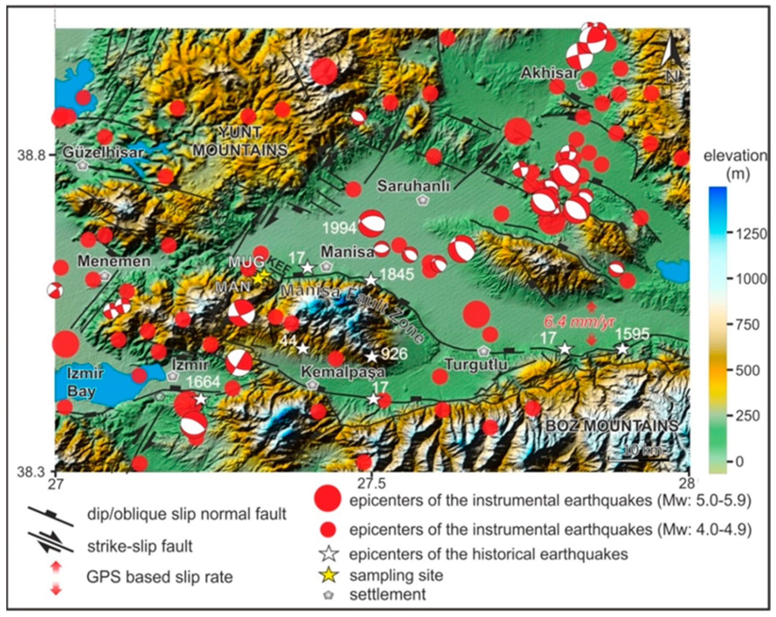
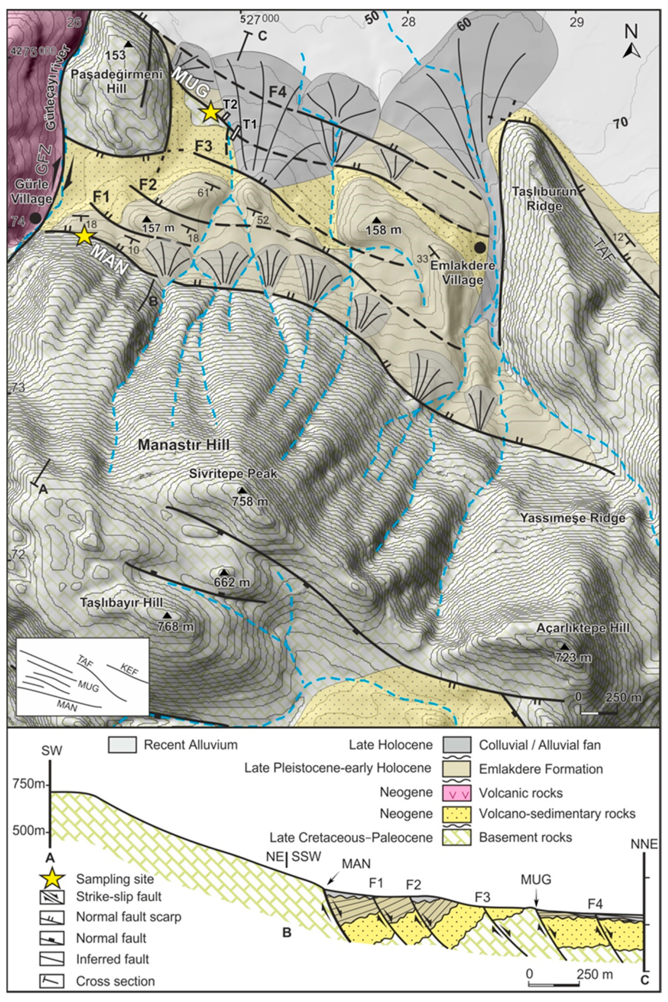
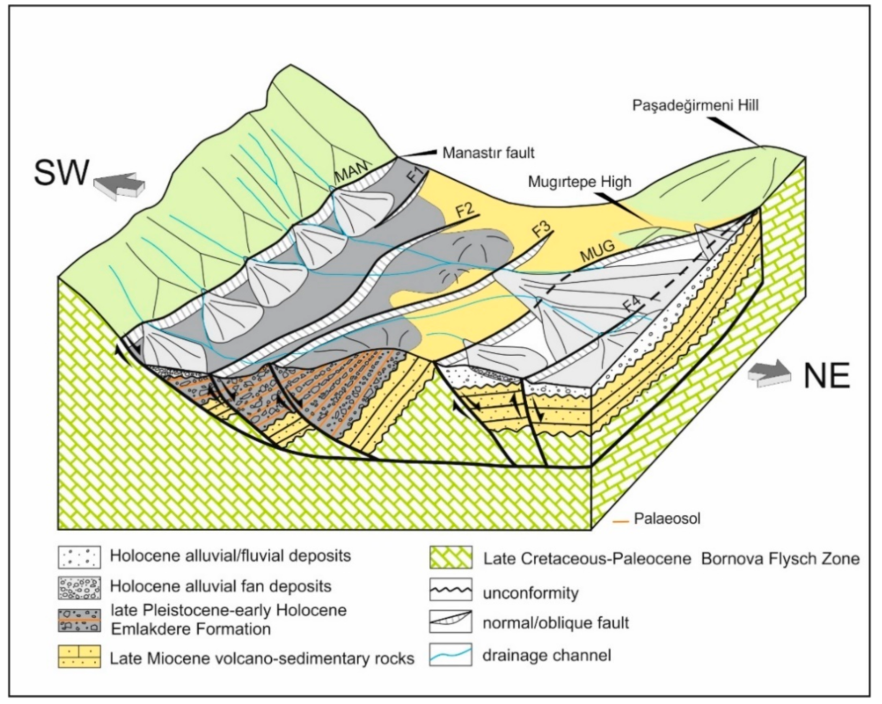
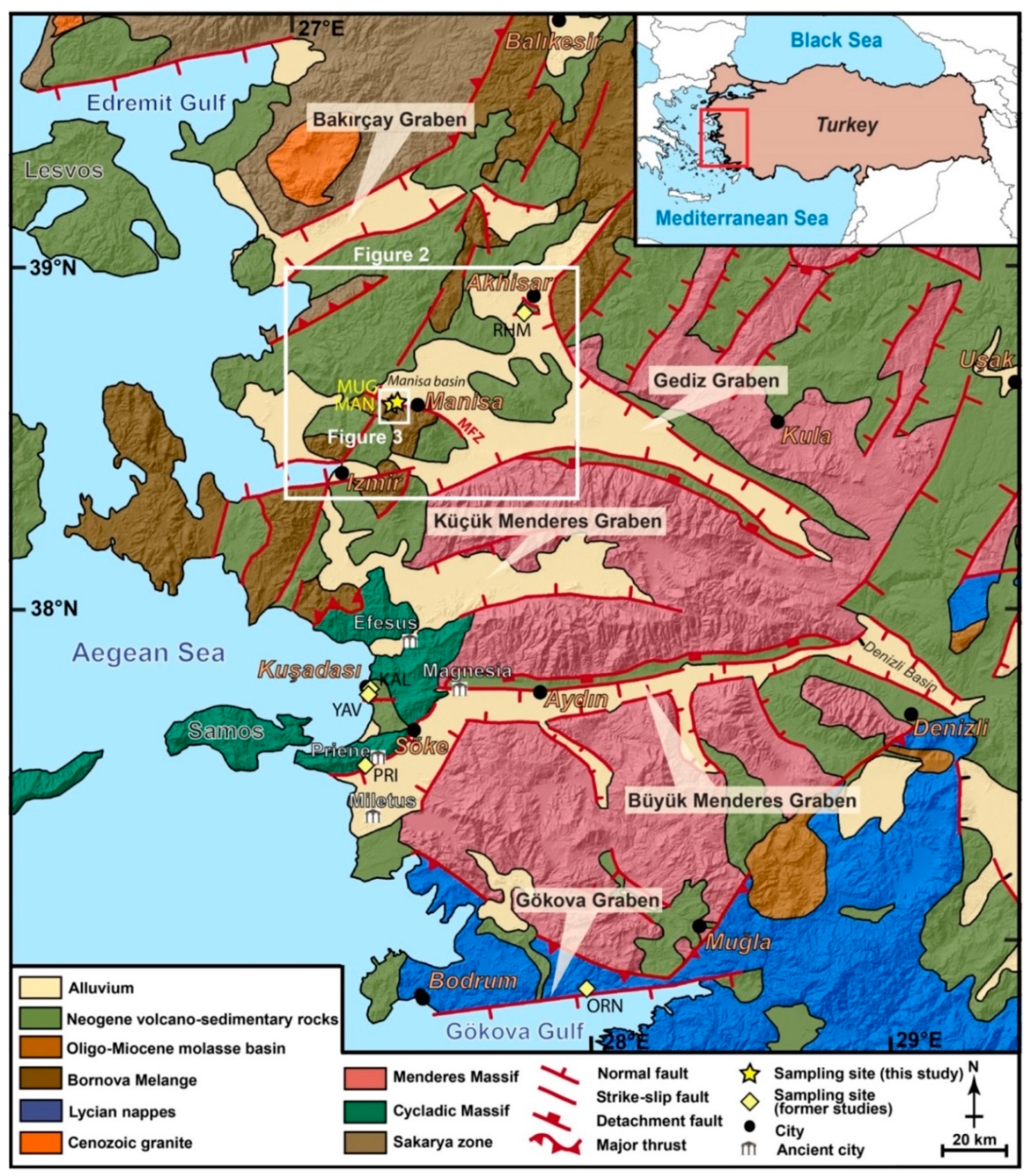
2. Study Area
3. Materials and Methods
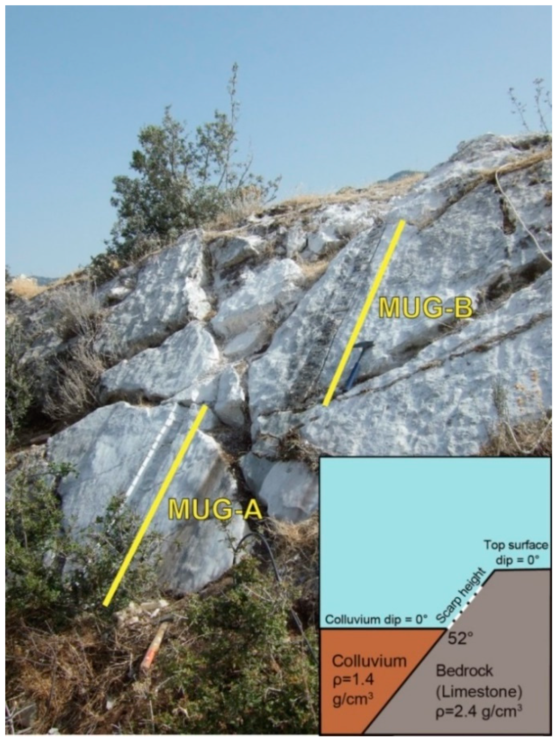
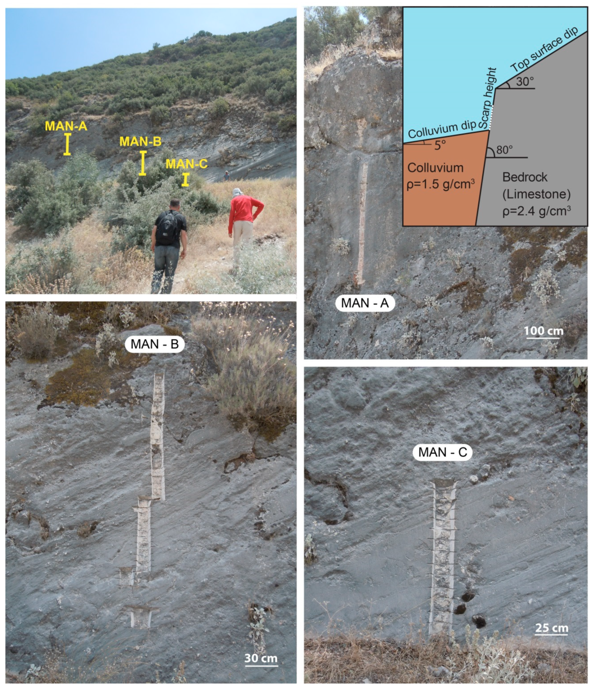
3.1. Sampling
3.2. Cosmogenic 36Cl Analysis
3.3. Fault Scarp Dating Tool
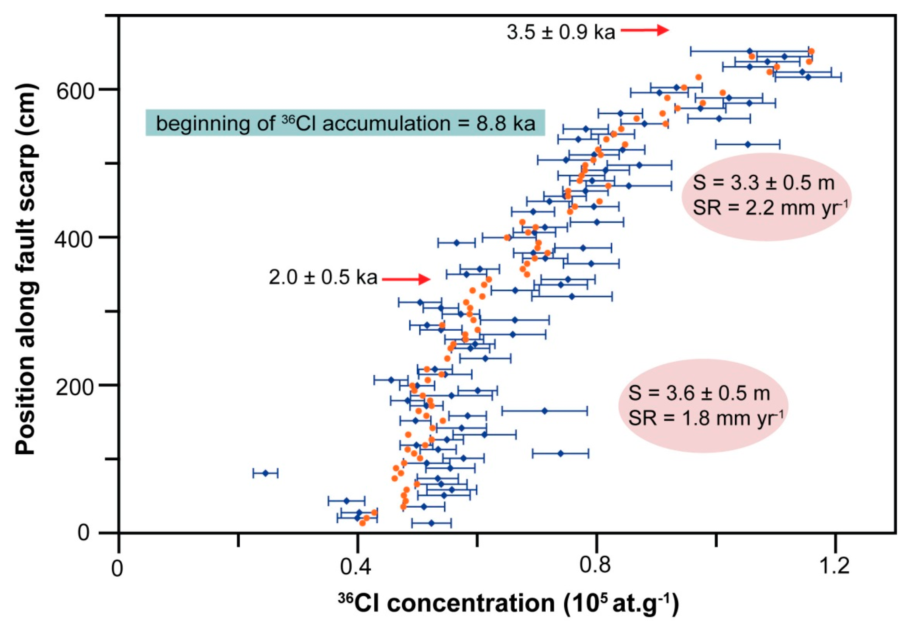
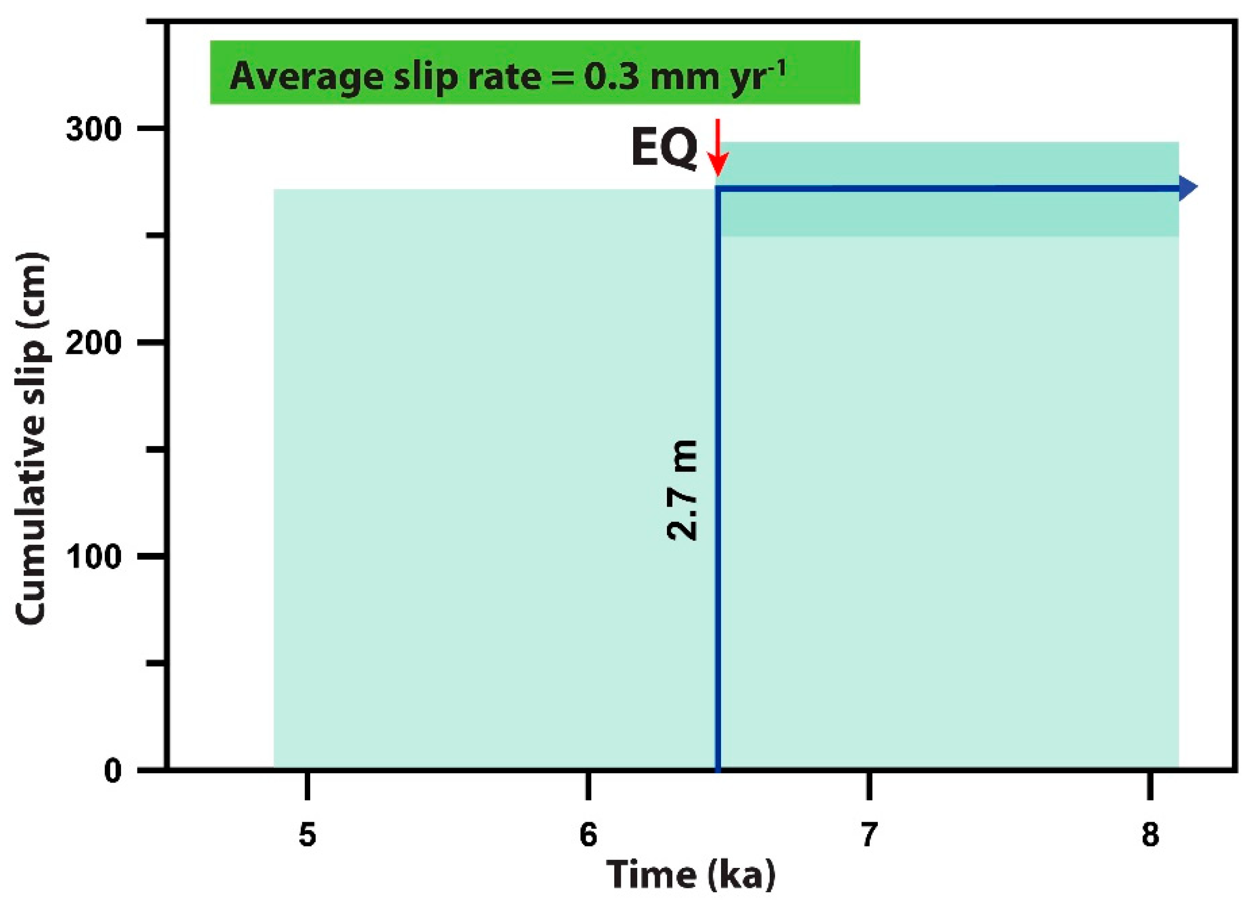
4. Results
4.1. Cosmogenic 36Cl Concentration Analysis
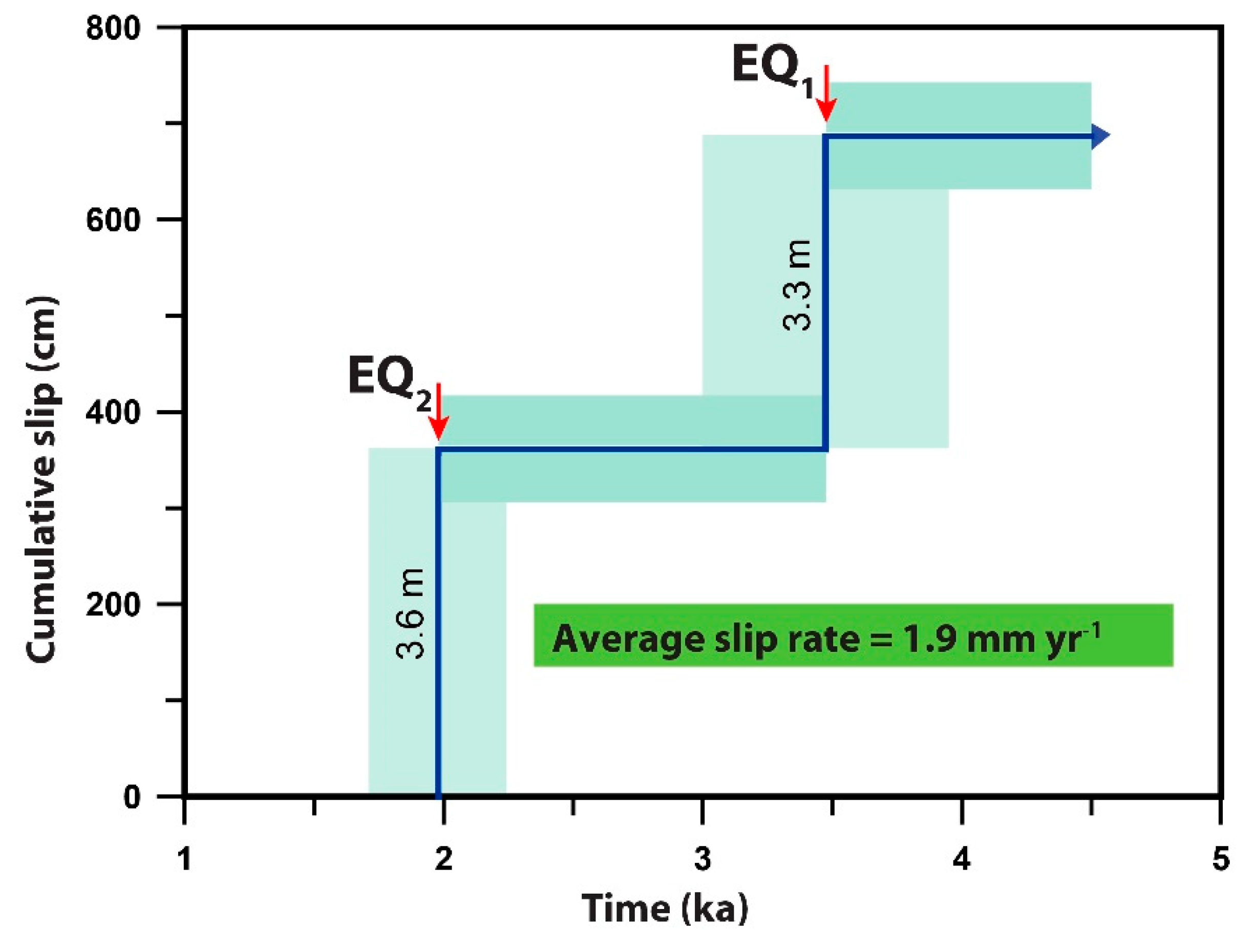
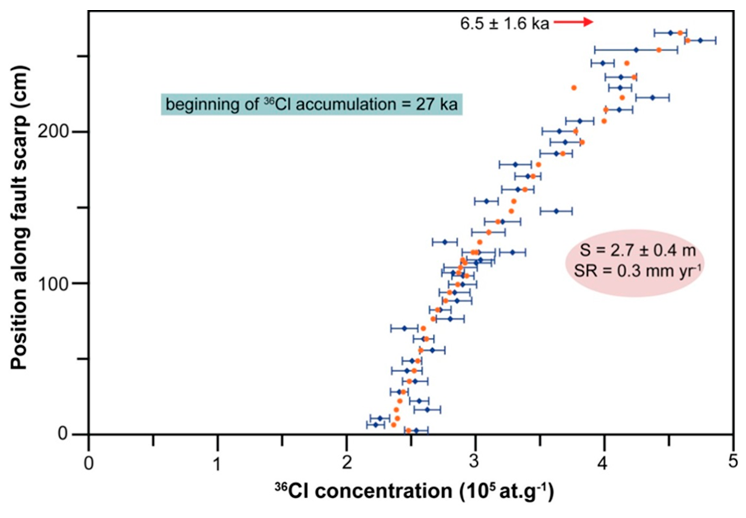
4.2. Time-Slip Histories of the Manastır and Mugırtepe Fault Scarps
5. Discussion
5.1. Plausibility of Earthquake Modeling
5.2. Evolution of the Western Manisa Fault Zone
5.3. Timing of Seismically Active Periods in Western Anatolia
6. Conclusions
Supplementary Materials
Author Contributions
Funding
Data Availability Statement
Acknowledgments
Conflicts of Interest
References
- Ambraseys, N. Earthquakes in the Mediterranean and Middle East: A Multidisciplinary Study of Seismicity up to 1900; Cambridge University Press: Cambridge, UK, 2009; p. 947. [Google Scholar]
- Shebalin, N.V.; Karnik, V.; Hadzievski, D. Catalogue of Earthquakes of the Balkan Region. I, UNDP-UNESCO Survey of the Seismicity of the Balkan Region; UNDP: Skopje, Yugoslavia, 1974; p. 600. [Google Scholar]
- Soysal, H.; Sipahioğlu, S.; Kolçak, D.; Altınok, Y. Historical Earthquake Catalogue of Turkey and Surrounding Area (2100 B.C.–1900 A.D.); Technical Report, TÜBİTAK, No. TBAG-341; The Scientific and Technological Research Council of Turkey: Ankara, Turkey, 1981. [Google Scholar]
- Papadopoulos, G.A. A Seismic History of Crete: Earthquakes and Tsunamis 2000 B.C.–2011 A.D. Ocelotos Publ. 2011, 65, 415. [Google Scholar]
- England, P.; Jackson, J.A. Uncharted seismic risk. Nat. Geosci. 2011, 4, 348–349. [Google Scholar] [CrossRef]
- Stein, S.; Friedrich, A.M. How much can we clear the crystal ball? Astron. Geophys. 2014, 55, 2.11–2.17. [Google Scholar] [CrossRef] [Green Version]
- Konstantinou, K.I.; Mouslopoulou, V.; Saltogianni, V. Seismicity and Active Faulting around the Metropolitan Area of Athens, Greece. Bull. Seismol. Soc. Am. 2020, 110, 1924–1941. [Google Scholar] [CrossRef]
- Morley, C.K. Patterns of displacement along large normal faults; implications for basin evolution and fault propagation, based on examples from East Africa. Am. Assoc. Pet. Geol. Bull. 1999, 83, 613–634. [Google Scholar]
- Biasi, G.P.; Weldon, R.J.; Fumal, T.E.; Seitz, G.G. Paleoseismic event dating and conditional probability of large earthquakes on the southern San Andreas fault, California. Bull. Seismol. Soc. Am. 2002, 92, 2761–2781. [Google Scholar] [CrossRef] [Green Version]
- Nicol, A.; Walsh, J.; Berryman, K.; Villamor, P. Interdependence of fault displacement rates and paleoearthquakes in an active rift. Geology 2006, 34, 865–868. [Google Scholar] [CrossRef]
- Nicol, A.; Walsh, J.J.; Villamor, P.; Seebeck, H.; Berryman, K.R. Normal fault interactions, paleoearthquakes and growth in an active rift. J. Struct. Geol. 2010, 32, 1101–1113. [Google Scholar] [CrossRef]
- Berryman, K.R.; Villamor, P.; Nairn, I.A.; Van Dissen, R.J.; Begg, J.G.; Lee, J.M. Late Pleistocene surface rupture history of the Paeroa Fault, Taupo Rift, New Zealand. N. Z. J. Geol. Geophys. 2008, 51, 135–158. [Google Scholar] [CrossRef]
- Friedrich, A.M.; Lee, J.; Wernicke, B.P.; Sieh, K. Geologic context of geodetic data across a Basin and Range normal fault, Crescent Valley, Nevada. Tectonics 2004, 23, TC2015. [Google Scholar] [CrossRef] [Green Version]
- Mouslopoulou, V.; Nicol, A.; Walsh, J.J.; Begg, J.G.; Townsend, D.B.; Hristopulos, D.T. Fault-slip accumulation in an active rift over thousands to millions of years and the importance of paleoearthquake sampling. J. Struct. Geol. 2012, 36, 71–80. [Google Scholar] [CrossRef] [Green Version]
- Zreda, M.; Noller, J.S. Ages of prehistoric earthquakes revealed by cosmogenic chlorine-36 in a bedrock fault scarp at Hebgen Lake. Science 1998, 282, 1097–1099. [Google Scholar] [CrossRef]
- Mitchell, S.G.; Matmon, A.; Bierman, P.R.; Enzel, Y.; Caffee, M.; Rizzo, D. Displacement history of a limtesone normal fault scarp, northern Israel, from cosmogenic 36Cl. J. Geophys. Res. 2001, 106, 4247–4264. [Google Scholar] [CrossRef]
- Benedetti, L.; Finkel, R.; King, G.; Armijo, R.; Papanastassiou, D.; Ryerson, F.J.; Flerit, F.; Farber, D.; Stavrakakis, G. Motion on the Kaparelli fault (Greece) prior to the 1981 earthquake sequence determined from Cl-36 cosmogenic dating. Terra Nova 2003, 15, 118–124. [Google Scholar] [CrossRef] [Green Version]
- Benedetti, L.; Finkel, R.; Papanastassiou, D.; King, G.; Armijo, R.; Ryerson, F.; Farber, D.; Flerit, F. Post-glacial slip history of the Sparta fault (Greece) determined by Cl-36 cosmogenic dating: Evidence for non-periodic earthquakes. Geophys. Res. Lett. 2002, 29, 87-1–87-4. [Google Scholar] [CrossRef]
- Benedetti, L.; Manighetti, I.; Gaudemer, Y.; Finkel, R.; Malavieille, Y.; Pou, K.; Arnold, M.; Aumaître, G.; Bourlès, D.; Keddadouche, K. Earthquake synchrony and clustering on Fucino faults (Central Italy) as revealed from in situ 36Cl exposure dating. J. Geophys. Res. Solid Earth 2013, 118, 4948–4974. [Google Scholar] [CrossRef]
- Palumbo, L.; Benedetti, L.; Bourles, D.; Cinque, A.; Finkel, R. Slip history of the Magnola fault (Apennines, Central Italy) from 36Cl surface exposure dating: Evidence for strong earthquake over the Holocene. Earth Planet. Sci. Lett. 2004, 225, 163–176. [Google Scholar] [CrossRef]
- Carcaillet, J.; Manighetti, I.; Chauvel, C.; Schlagenhauf, A.; Nicole, J.M. Identifying past earthquakes on an active normal fault (Magnola, Italy) from the chemical analysis of its exhumed carbonate fault plane. Earth Planet. Sci. Lett. 2008, 271, 145–158. [Google Scholar] [CrossRef]
- Schlagenhauf, A.; Gaudemer, Y.; Benedetti, L.; Manighetti, I.; Palumbo, L.; Schimmelpfennig, I.; Finkel, R.; Pou, K. Using in situ Chlorine-36 cosmonuclide to recover past earthquake histories on limestone normal fault scarps: A reappraisal of methodology and interpretations. Geophys. J. Int. 2010, 182, 36–72. [Google Scholar] [CrossRef] [Green Version]
- Schlagenhauf, A.; Manighetti, I.; Benedetti, L.; Gaudemer, Y.; Finkel, R.; Malavieille, J.; Pou, K. Earthquake supercycles in Central Italy, inferred from 36Cl exposure dating. Earth Planet. Sci. Lett. 2011, 307, 487–500. [Google Scholar] [CrossRef]
- Akçar, N.; Tikhomirov, D.; Özkaymak, Ç.; Alfimov, V.; Ivy-Ochs, S.; Sözbilir, H.; Uzel, B.; Schlüchter, C. 36Cl Exposure dating of paleoearthquakes in the Eastern Mediterranean: First results from Western Anatolian Extensional Province, Manisa Fault Zone, Turkey. Geol. Soc. Am. Bull. 2012, 124, 1724–1735. [Google Scholar] [CrossRef]
- Mouslopoulou, V.; Moraetis, D.; Benedetti, L.; Guillou, V.; Bellier, O.; Hristopulos, D. Normal faulting in the forearc of the Hellenic subduction margin: Paleoearthquake history and kinematics of the Spili Fault, Crete, Greece. J. Struct. Geol. 2014, 66, 298–308. [Google Scholar] [CrossRef]
- Tikhomirov, D.; Akçar, N.; Ivy-Ochs, S.; Alfimov, V.; Schlüchter, C. Calculation of shielding factors for production of cosmogenic nuclides in fault scarps. Quat. Geochronol. 2014, 19, 181–193. [Google Scholar] [CrossRef]
- Tikhomirov, D. An Advanced Model for Fault Scarp Dating and Paleoearthquake Reconstruction, with a Case Study of the Gediz Graben Formation (Turkey). Ph.D. Thesis, University of Bern, Bern, Switzerland, 2014; p. 113. [Google Scholar]
- Kong, P.; Fink, D.; Chunguang, N.; Xiao, W. Dip-slip rate determined by cosmogenic surface dating on a Holocene scarp of the Daju fault, Yunnan, China. Tectonophysics 2010, 493, 106–112. [Google Scholar] [CrossRef]
- Tesson, J.; Pace, B.; Benedetti, L.; Visini, F.; Delli Rocioli, M.; Arnold, M.; Aumaître, G.; Bourlès, D.L.; Keddadouche, K. Seismic slip history of the Pizzalto fault (central Apennines, Italy) using in situ-produced 36Cl cosmic ray exposure dating and rare earth element concentrations. J. Geophys. Res. Solid Earth 2016, 121, 1983–2003. [Google Scholar] [CrossRef] [Green Version]
- Cowie, P.A.; Phillips, R.J.; Roberts, G.P.; McCaffrey, K.; Zijerveld, L.J.J.; Gregory, L.C.; Faure Walker, J.; Wedmore, L.N.J.; Dunai, T.J.; Binnie, S.A.; et al. Orogen-scale uplift in the central Italian Apennines drives episodic behaviour of earthquake faults. Sci. Rep. 2017, 7, 44858. [Google Scholar] [CrossRef]
- Beck, J.; Wolfers, S.; Roberts, J.P. Bayesian earthquake dating and seismic hazard assessment using chlorine-36 measurements (BED v1). Geosci. Model Dev. 2018, 11, 4383–4397. [Google Scholar] [CrossRef] [Green Version]
- Mechernich, S.; Schneiderwind, S.; Mason, J.; Papanikolaou, I.D.; Deligiannakis, G.; Pallikarakis, A.; Reicherter, K. The seismic history of the Pisia fault (eastern Corinth rift, Greece) from fault plane weathering features and cosmogenic 36Cl dating. J. Geophys. Res. Solid Earth 2018, 123, 4266–4284. [Google Scholar] [CrossRef] [Green Version]
- Mozafari, N.; Sümer, Ö.; Tikhomirov, D.; Ivy-Ochs, S.; Alfimov, V.; Vockenhuber, C.; İnci, U.; Sözbilir, H.; Akçar, N. Holocene seismic activity of the Priene-Sazlı Fault revealed by cosmogenic 36Cl, western Anatolia, Turkey. Turk. J. Earth Sci. 2019, 28, 410–437. [Google Scholar] [CrossRef]
- Mozafari, N.; Tikhomirov, D.; Sümer, Ö.; Özkaymak, Ç.; Uzel, B.; Yeşilyurt, S.; Ivy-Ochs, S.; Vockenhuber, C.; Sözbilir, H.; Akçar, N. Dating of active normal fault scarps in the Büyük Menderes Graben (western Anatolia) and its implications for seismic history. Quat. Sci. Rev. 2019, 220, 111–123. [Google Scholar] [CrossRef]
- Mozafari, N.; Özkaymak, Ç.; Sümer, Ö.; Tikhomirov, D.; Uzel, B.; Yeşilyurt, S.; Ivy-Ochs, S.; Vockenhuber, C.; Sözbilir, H.; Akçar, N. Seismic history of western Anatolia during the last 16 kyr determined by cosmogenic 36Cl dating. Swiss J. Geosci. 2021. in revision. [Google Scholar]
- Tesson, J.; Benedetti, L. Seismic history from in situ 36Cl cosmogenic nuclide data on limestone fault scarps using Bayesian reversible jump Markov chain Monte Carlo. Quat. Geochronol. 2019, 52, 1–20. [Google Scholar] [CrossRef] [Green Version]
- Tikhomirov, D.; Mozafari, N.; Ivy-Ochs, S.; Alfimov, V.; Vockenhuber, C.; Akçar, N. Fault Scarp Dating Tool—A MATLAB code for fault scarp dating with in-situ chlorine-36 along with datasets of Yavansu and Kalafat faults. Data Brief 2019, 26, 104476. [Google Scholar] [CrossRef]
- Goodall, H.J.; Gregory, L.C.; Wedmore, L.N.J.; McCaffrey, K.J.W.; Amey, R.M.J.; Roberts, G.P.; Shanks, R.P.; Phillips, R.J.; Hooper, A. Determining histories of slip on normal faults with bedrock scarps using cosmogenic nuclide exposure data. Tectonics 2021, 40, e2020TC006457. [Google Scholar] [CrossRef]
- Crone, A.J.; Machette, M.N.; Bonilla, M.G.; Lienkaemper, J.J.; Pierce, K.L.; Scott, W.E.; Bucknam, R.C. Surface Faulting Accompanying the Borah Peak Earthquake and Segmentation of the Lost River Fault, Central Idaho. Bull. Seismol. Soc. Am. 1987, 77, 739–770. [Google Scholar]
- Stewart, I.S.; Hancock, P.L. Normal fault zone evolution and fault scarp degradation in the Aegean region. Basin Res. 1988, 1, 139–153. [Google Scholar] [CrossRef]
- Hancock, P.L.; Barka, A.A. Kinematic indicators on active normal faults in western Turkey. J. Struct. Geol. 1987, 9, 573–584. [Google Scholar] [CrossRef]
- Sümer, Ö.; Inci, U.; Sözbilir, H. Tectonic evolution of the Söke Basin: Extension-dominated transtensional basin formation in western part of the Büyük Menderes Graben, Western Anatolia, Turkey. J. Geodyn. 2013, 65, 148–175. [Google Scholar] [CrossRef]
- Sözbilir, H.; Sarı, B.; Uzel, B.; Sümer, Ö.; Akkiraz, S. Tectonic implications of transtensional supradetachment basin development in an extension-parallel transfer zone: The Kocaçay Basin, western Anatolia, Turkey. Basin Res. 2011, 23, 423–448. [Google Scholar] [CrossRef]
- Özkaymak, Ç.; Sözbilir, H. Stratigraphic and structural evidence for fault reactivation: The active Manisa fault zone, western Anatolia. Turk. J. Earth Sci. 2008, 17, 615–635. [Google Scholar]
- Uzel, B.; Sözbilir, H.; Özkaymak, Ç.; Kaymakçı, N.; Langeris, C.G. Structural evidence for strike-slip deformation in the İzmir-Balıkesir Transfer Zone and consequences for late Cenozoic evolution of western Anatolia (Turkey). J. Geodyn. 2013, 65, 94–116. [Google Scholar] [CrossRef]
- Özkaymak, Ç.; Sözbilir, H.; Uzel, B. Neogene–Quaternary evolution of the Manisa Basin: Evidence for variation in the stress pattern of the İzmir-Balıkesir Transfer Zone, western Anatolia. J. Geodyn. 2013, 65, 117–135. [Google Scholar] [CrossRef]
- Duman, T.Y.; Çan, T.; Emre, Ö.; Kadirioğlu, F.T.; Başarır Baştürk, N.; Kılıç, T.; Arslan, S.; Özalp, S.; Kartal, R.F.; Kalafat, D.; et al. Seismotectonics database of Turkey. Bull. Earthq. Eng. 2018, 16, 3277–3316. [Google Scholar] [CrossRef]
- Tan, O.; Tapirdamaz, M.C.; Yörük, A. The earthquakes catalogues for Turkey. Turk. J. Earth Sci. 2008, 17, 405–418. [Google Scholar]
- Eyübagil, E.E.; Solak, H.İ.; Kavak, U.S.; Tiryakioglu, İ.; Sözbilir, H.; Aktuğ, B.; Özkaymak, Ç. Present day strike-slip deformation within the southern part of the İzmir-Balıkesir Transfer Zone based on GNSS data and implications for seismic hazard assessment in western Anatolia, Turk. J. Earth Sci. 2021, 30, 143–160. [Google Scholar]
- Pavlides, S.; Caputo, R. Magnitude versus faults’ surface parameters: Quantitative relationships from the Aegean Region. Tectonophysics 2004, 380, 159–188. [Google Scholar] [CrossRef]
- Bozkurt, E.; Sozbilir, H. Evolution of the large-scale active manisa fault, Southwest Turkey: Implications on fault development and regional tectonics. Geodin. Acta 2006, 19, 427–453. [Google Scholar] [CrossRef]
- Nicol, A.; Mouslopoulou, V.; Begg, J.; Oncken, O. Displacement accumulation and sampling of paleoearthquakes on active normal faults of Crete in the eastern Mediterranean. Geochem. Geophys. Geosyst. 2020, 21, e2020GC009265. [Google Scholar] [CrossRef]
- United States Geological Survey National Earthquake Information Center. Available online: https://earthquake.usgs.gov/earthquakes/eventpage/us7000c7y0/executive (accessed on 26 October 2021).
- McKenzie, D. Active tectonics of the Alpine-Himalayan belt: The Aegean Sea and surrounding regions. Geophys. J. Int. 1978, 55, 217–254. [Google Scholar] [CrossRef] [Green Version]
- Ambraseys, N.N.; Jackson, J.A. Faulting associated with historical and recent earthquakes in the Eastern Mediterranean region. Geophys. J. Int. 1998, 133, 390–406. [Google Scholar] [CrossRef] [Green Version]
- Bozkurt, E. Neotectonics of Turkey: A synthesis. Geodin. Acta 2001, 14, 3–30. [Google Scholar] [CrossRef] [Green Version]
- Ambraseys, N.N. Engineering seismology. Earthq. Eng. Struct. Dyn. 1988, 17, 51–105. [Google Scholar] [CrossRef]
- Guidoboni, E.; Comastri, A.; Triana, G. Catalogue of Ancient Earthquakes in the Mediterranean Area up to the 10th Century; Istituto Nazionale di Geofisica: Rome, Italy, 1994; ISBN 88-85213-06-5. [Google Scholar]
- Özkaymak, Ç.; Sözbilir, H.; Uzel, B.; Akyüz, H.S. Geological and palaeoseismological evidence for Late Pleistocene-Holocene activity on the Manisa Fault Zone, western Anatolia. Turk. J. Earth Sci. 2011, 20, 449–474. [Google Scholar]
- Özkaymak, Ç.; Sözbilir, H. Tectonic Geomorphology of the Spildağı High Ranges, Western Anatolia. Geomorphology 2012, 173–174, 128–140. [Google Scholar] [CrossRef]
- Allen, C.R. Geological criteria for evaluating seismicity. Geol. Soc. Am. Bull. 1974, 86, 1041–1057. [Google Scholar] [CrossRef]
- Paton, S. Active normal faulting, drainage patterns and sedimentation in southwestern Turkey. J. Geol. Soc. 1992, 149, 1031–1044. [Google Scholar] [CrossRef]
- Hanson, K.L.; Kelson, K.I.; Angell, M.A.; Lettis, W.R. Techniques for Identifying Faults and Determining Their Origins; Contract Rep. NUREG/CR-5503; Nuclear Regulatory Commission: Washington, DC, USA, 1999; p. 504. [Google Scholar]
- McCalpin, J.P. (Ed.) Paleoseismology. In International Geophysics, 2nd ed.; Academic Press: Cambridge, MA, USA, 2009; p. 629. [Google Scholar]
- Yeats, R. Active Faults Related to Folding. In Active Tectonics: Studies in Geophysics; National Academy Press: Washington, DC, USA, 1986. [Google Scholar]
- Ergin, K.; Güçlü, U.; Uz, Z. A Catalogue of Earthquakes for Turkey and Surrounding Area (11 AD.-1964); Technical Report, no. 24; İstanbul Technical University: İstanbul, Turkey, 1967. [Google Scholar]
- Ambraseys, N.N.; Finkel, C.F. The Seismicity of Turkey and Adjacent Areas: A Historical Review, 1500–1800; Eren Publishing & Book Trade: İstanbul, Turkey, 1995; p. 240. [Google Scholar]
- Papazachos, B.; Papazachou, C. The Earthquakes of Greece, Technical Books Edition; Thessaloniki: Thessaloniki, Greece, 1997; p. 304. [Google Scholar]
- Kandilli Observatory and Earthquake Research Institute. Boğaziçi University. Available online: http://www.koeri.boun.edu.tr/new/en (accessed on 26 October 2021).
- Stone, J.O.; Allan, G.L.; Fifield, L.K.; Cresswell, R.G. Cosmogenic chlorine-36 from calcium spallation. Geochim. Cosmochim. Acta 1996, 60, 679–692. [Google Scholar] [CrossRef]
- Ivy-Ochs, S.; Synal, H.A.; Roth, C.; Schaller, M. Initial results from isotope dilution for Cl and Cl-36 measurements at the PSI/ETH Zurich AMS facility. Nucl. Instrum. Methods Phys. Res. Sect. B Beam Interact. Mater. At. 2004, 223–224, 623–627. [Google Scholar] [CrossRef]
- Ivy-Ochs, S.; Poschinger, A.V.; Synal, H.A.; Maisch, M. Surface exposure dating of the Flims landslide, Graubunden, Switzerland. Geomorphology 2009, 103, 104–112. [Google Scholar] [CrossRef]
- Elmore, D.; Ma, X.; Miller, T.; Mueller, K.; Perry, M.; Rickey, F.; Sharma, P.; Simms, P.; Lipschutz, M.; Vogt, S. Status and plans for the PRIME Lab AMS facility. Nucl. Instrum. Methods Phys. Res. Sect. B Beam Interact. Mater. At. 1997, 123, 69–72. [Google Scholar] [CrossRef]
- Evans, J.M.; Stone, J.O.H.; Fifield, L.K.; Cresswell, R.G. Cosmogenic chlorine-36 production in K-feldspar. Nucl. Instrum. Methods Phys. Res. Sect. B Beam Interact. Mater. At. 1997, 123, 334–340. [Google Scholar] [CrossRef]
- Fink, D.; Vogt, S.; Hotchkis, M. Cross-sections for Cl-36 from Ti at E-p=35–150 MeV: Applications to in-situ exposure dating. Nucl. Instrum. Methods Phys. Res. Sect. B Beam Interact. Mater. At. 2000, 172, 861–866. [Google Scholar] [CrossRef]
- Stone, J.O. Terrestrial chlorine-36 production from spallation of iron. In Proceedings of the 10th International Conference on Accelerator Mass Spectrometry, Berkeley, CA, USA, 5–10 September 2005. [Google Scholar]
- Alfimov, V.; Ivy-Ochs, S. How well do we understand production of Cl-36 in limestone and dolomite? Quat. Geochronol. 2009, 4, 462–474. [Google Scholar] [CrossRef]
- Stone, J.O. Air pressure and cosmogenic isotope production. J. Geophys. Res. 2000, 105, 23753–23759. [Google Scholar] [CrossRef]
- Heisinger, B.; Lal, D.; Jull, A.J.T.; Kubik, P.; Ivy-Ochs, S.; Neumaier, S.; Knie, K.; Lazarev, V.; Nolte, E. Production of selected cosmogenic radionuclides by muons: 1. Fast muons. Earth Planet. Sci. Lett. 2002, 200, 345–355. [Google Scholar] [CrossRef]
- Heisinger, B.; Lal, D.; Jull, A.J.T.; Kubik, P.; Ivy-Ochs, S.; Knie, K.; Nolte, E. Production of selected cosmogenic radionuclides by muons: 2. Capture of negative muons. Earth Planet. Sci. Lett. 2002, 200, 357–369. [Google Scholar] [CrossRef]
- Wells, D.L.; Coppersmith, J.K. New empirical relationships among magnitude, rupture length, rupture width, rupture area, and surface displacement. Bull. Seismol. Soc. Am. 1994, 84, 974–1002. [Google Scholar]
- Wesnousky, S.G. Displacement and Geometrical Characteristics of Earthquake Surface Ruptures: Issues and Implications for Seismic-Hazard Analysis and the Process of Earthquake Rupture. Bull. Seismol. Soc. Am. 2008, 98, 1609. [Google Scholar] [CrossRef]
- Walsh, J.J.; Watterson, J. Analysis of the relationship between the displacements and dimensions of faults. J. Struct. Geol. 1988, 10, 239–247. [Google Scholar] [CrossRef]
- Marrett, R.; Allmendinger, R.W. Estimates of strain due to brittle faulting: Sampling of fault populations. J. Struct. Geol. 1991, 13, 735–738. [Google Scholar] [CrossRef]
- Kim, Y.S.; Sanderson, D.J. The relationship between displacement and length of faults: A review. Earth-Sci. Rev. 2005, 68, 317–334. [Google Scholar] [CrossRef]
- Perrey, A. Note sur les tremblements de terre ressentis en 1847. Mem. Acad. Sci. Arts Belles-Lett. 1848, 1847–1848, 68–115. [Google Scholar]
- Denton, G.H.; Anderson, R.F.; Toggweiler, J.R.; Edwards, R.L.; Schaefer, J.M.; Putnam, A.E. The Last Glacial Termination. Science 2010, 328, 1652–1656. [Google Scholar] [CrossRef] [PubMed] [Green Version]
- Shakun, J.D.; Carlson, A.E. A global perspective on Last Glacial Maximum to Holocene climate change. Quat. Sci. Rev. 2010, 29, 1801–1816. [Google Scholar] [CrossRef]
- Stern, J.V.; Lisiecki, L.E. Termination 1 timing in radiocarbon-dated regional benthic δ18O stacks. Paleoceanography 2014, 29, 1127–1142. [Google Scholar] [CrossRef] [Green Version]


| Manastır Fault | Mugırtepe Fault | |
|---|---|---|
| Latitude | 38° 36.729’ N | 38° 37.101’ N |
| Longitude | 27° 17.917’ E | 27° 18.498’ E |
| Altitude | 141 m | 80 m |
| Scarp strike | N88° E | N65° W |
| Colluvium dip | 5° | 0° |
| Scarp dip | 80° | 52° |
| Top surface dip | 30° | 0° |
| Scarp height | 1200 cm | 415 cm |
| Scarp rock density | 2.4 g/cm3 | 2.4 g/cm3 |
| Colluvium density | 1.5 g/cm3 | 1.4 g/cm3 |
| Rock water content | 0.1% | 0.1% |
| Colluvium water content | 1% | 1% |
| Spallation on Ca: 48.8 ± 3.5 at g−1 yr−1 [70] Spallation on K of 170 ± 25 at g−1 yr−1 [74] Spallation on Ti of 13 ± 3 at g−1 yr−1 [75] Spallation on Fe of 1.9 ± 0.2 at g−1 yr−1 [76] Epithermal neutrons from fast neutrons: 760 ± 150 n/g−1 yr−1 [77] Scaling scheme [78] | ||
| Sample Name | Top Position (cm) | Bottom Position (cm) | Thickness(cm) | 36Cl * (105 at/g) | 36Cl Uncertainty * (105 at/g) | Cl Total *(ppm) | Cl Total Uncertainty * (ppm) | Ca † (ppm) | O (%) | C (%) |
|---|---|---|---|---|---|---|---|---|---|---|
| MAN-A02 | 645 | 638 | 2.0 | 1.056 | 0.099 | 9.3 | 0.09 | 372,143 | 48.78 | 11.16 |
| MAN-A03 | 638 | 631 | 2.0 | 1.114 | 0.046 | 9.9 | 0.10 | 346,429 | 52.13 | 10.39 |
| MAN-A04 | 631 | 624 | 2.0 | 1.086 | 0.054 | 7.9 | 0.08 | 386,429 | 46.93 | 11.59 |
| MAN-A05 | 624 | 617 | 2.0 | 1.056 | 0.045 | 11.2 | 0.11 | 372,143 | 48.78 | 11.16 |
| MAN-A06 | 617 | 610 | 2.0 | 1.144 | 0.049 | 10.6 | 0.11 | 375,714 | 48.32 | 11.27 |
| MAN-A07 | 610 | 603 | 3.0 | 1.154 | 0.055 | 9.3 | 0.09 | 346,429 | 52.13 | 10.39 |
| MAN-A09 | 596 | 589 | 2.0 | 0.934 | 0.043 | 9.2 | 0.09 | 346,429 | 52.13 | 10.39 |
| MAN-A10 | 589 | 582 | 2.0 | 0.905 | 0.048 | 10.6 | 0.11 | 373,571 | 48.60 | 11.21 |
| MAN-A11 | 582 | 575 | 2.0 | 1.021 | 0.056 | 9.7 | 0.10 | 346,429 | 52.13 | 10.39 |
| MAN-A12 | 575 | 568 | 2.0 | 1.055 | 0.044 | 9.5 | 0.09 | 373,571 | 48.60 | 11.21 |
| MAN-A13 | 568 | 561 | 3.0 | 0.974 | 0.043 | 7.2 | 0.07 | 368,571 | 49.25 | 11.06 |
| MAN-A14 | 561 | 554 | 2.0 | 0.840 | 0.037 | 5.4 | 0.05 | 362,143 | 50.08 | 10.86 |
| MAN-A15 | 554 | 547 | 3.0 | 1.005 | 0.052 | 7.9 | 0.08 | 350,714 | 51.57 | 10.52 |
| MAN-A16 | 547 | 540 | 2.0 | 0.880 | 0.040 | 8.3 | 0.08 | 370,000 | 49.06 | 11.10 |
| MAN-A17 | 540 | 533 | 2.0 | 0.782 | 0.038 | 6.8 | 0.07 | 346,429 | 52.13 | 10.39 |
| MAN-A18 | 533 | 526 | 2.0 | 0.827 | 0.036 | 5.7 | 0.06 | 346,429 | 52.13 | 10.39 |
| MAN-A19 | 526 | 519 | 2.0 | 0.769 | 0.034 | 3.9 | 0.04 | 346,429 | 52.13 | 10.39 |
| MAN-A20 | 519 | 512 | 2.0 | 1.053 | 0.054 | 5.9 | 0.06 | 360,714 | 50.27 | 10.82 |
| MAN-A21 | 512 | 505 | 2.0 | 0.843 | 0.037 | 4.9 | 0.05 | 346,429 | 52.13 | 10.39 |
| MAN-A22 | 505 | 498 | 2.0 | 0.796 | 0.042 | 10.7 | 0.11 | 346,429 | 52.13 | 10.39 |
| MAN-A23 | 498 | 491 | 2.0 | 0.749 | 0.047 | 8.2 | 0.08 | 346,429 | 52.13 | 10.39 |
| MAN-A24 | 491 | 484 | 3.0 | 0.871 | 0.054 | 8.7 | 0.09 | 346,429 | 52.13 | 10.39 |
| MAN-A25 | 484 | 477 | 2.0 | 0.815 | 0.040 | 7.9 | 0.08 | 346,429 | 52.13 | 10.39 |
| MAN-A26 | 477 | 470 | 2.0 | 0.774 | 0.039 | 8.4 | 0.08 | 346,429 | 52.13 | 10.39 |
| MAN-A27 | 470 | 463 | 2.0 | 0.792 | 0.037 | 9.8 | 0.10 | 346,429 | 52.13 | 10.39 |
| MAN-A28 | 463 | 456 | 2.0 | 0.854 | 0.071 | 10.2 | 0.10 | 369,286 | 49.16 | 11.08 |
| MAN-A29 | 456 | 449 | 2.0 | 0.781 | 0.038 | 11.7 | 0.12 | 341,429 | 52.78 | 10.24 |
| MAN-A30 | 449 | 442 | 2.0 | 0.747 | 0.035 | 10.0 | 0.10 | 345,000 | 52.31 | 10.35 |
| MAN-A31 | 442 | 435 | 2.0 | 0.721 | 0.038 | 9.4 | 0.09 | 370,714 | 48.97 | 11.12 |
| MAN-A32 | 435 | 428 | 2.0 | 0.795 | 0.042 | 10.0 | 0.10 | 354,286 | 51.11 | 10.63 |
| MAN-A33 | 428 | 421 | 2.0 | 0.694 | 0.036 | 8.9 | 0.09 | 353,571 | 51.20 | 10.61 |
| MAN-A35 | 414 | 407 | 2.0 | 0.800 | 0.045 | 13.5 | 0.13 | 317,857 | 55.84 | 9.54 |
| MAN-A36 | 407 | 400 | 2.0 | 0.713 | 0.038 | 25.1 | 0.25 | 321,429 | 55.38 | 9.64 |
| MAN-A37 | 400 | 393 | 2.0 | 0.696 | 0.035 | 21.5 | 0.21 | 320,000 | 55.56 | 9.60 |
| MAN-A38 | 393 | 386 | 2.0 | 0.654 | 0.045 | 30.8 | 0.31 | 298,571 | 58.35 | 8.96 |
| MAN-A39 | 386 | 379 | 2.0 | 0.565 | 0.031 | 13.2 | 0.13 | 337,143 | 53.33 | 10.11 |
| MAN-B01 | 379 | 372 | 3.0 | 0.777 | 0.047 | 10.7 | 0.05 | 345,000 | 52.31 | 10.35 |
| MAN-B02 | 372 | 365.5 | 2.0 | 0.694 | 0.033 | 4.8 | 0.11 | 345,000 | 52.31 | 10.35 |
| MAN-B03 | 365.5 | 357.5 | 2.0 | 0.714 | 0.038 | 11.3 | 0.13 | 338,571 | 53.15 | 10.16 |
| MAN-B04 | 357.5 | 351 | 2.0 | 0.791 | 0.046 | 13.3 | 0.08 | 343,571 | 52.50 | 10.31 |
| MAN-B05 | 351 | 343 | 2.0 | 0.604 | 0.033 | 7.6 | 0.07 | 347,143 | 52.03 | 10.41 |
| MAN-B06 | 343 | 336.5 | 2.0 | 0.582 | 0.034 | 6.9 | 0.06 | 357,143 | 50.73 | 10.71 |
| MAN-B07 | 336.5 | 329.5 | 2.0 | 0.752 | 0.045 | 5.9 | 0.12 | 325,000 | 54.91 | 9.75 |
| MAN-B08 | 329.5 | 322 | 2.0 | 0.740 | 0.045 | 11.8 | 0.23 | 315,714 | 56.12 | 9.47 |
| MAN-B09 | 322 | 314 | 2.0 | 0.664 | 0.040 | 23.1 | 0.18 | 315,714 | 56.12 | 9.47 |
| MAN-B10 | 314 | 306 | 2.0 | 0.758 | 0.067 | 17.9 | 0.25 | 323,571 | 55.10 | 9.71 |
| MAN-B11 | 306 | 298 | 2.0 | 0.504 | 0.036 | 25.2 | 0.21 | 317,857 | 55.84 | 9.54 |
| MAN-B12 | 298 | 290.5 | 2.0 | 0.539 | 0.029 | 21.3 | 0.13 | 333,571 | 53.80 | 10.01 |
| MAN-B13 | 305.5 | 296.5 | 2.0 | 0.572 | 0.031 | 13.1 | 0.09 | 341,429 | 52.78 | 10.24 |
| MAN-B14 | 296.5 | 289.5 | 2.0 | 0.663 | 0.058 | 9.1 | 0.09 | 350,000 | 51.66 | 10.50 |
| MAN-B15 | 289.5 | 282.5 | 2.0 | 0.516 | 0.029 | 8.7 | 0.08 | 325,000 | 54.91 | 9.75 |
| MAN-B16 | 282.5 | 277.0 | 2.0 | 0.539 | 0.035 | 7.5 | 0.05 | 364,286 | 49.81 | 10.93 |
| MAN-B17 | 277.0 | 270.0 | 2.0 | 0.659 | 0.055 | 4.9 | 0.10 | 352,143 | 51.38 | 10.56 |
| MAN-B18 | 270.0 | 263.5 | 2.0 | 0.578 | 0.032 | 9.5 | 0.08 | 357,143 | 50.73 | 10.71 |
| MAN-B19 | 263.5 | 257.5 | 2.0 | 0.596 | 0.033 | 8.0 | 0.10 | 346,429 | 52.13 | 10.39 |
| MAN-B20 | 257.5 | 252.0 | 2.0 | 0.589 | 0.032 | 10.4 | 0.10 | 346,429 | 52.13 | 10.39 |
| MAN-B21 | 252.0 | 230.0 | 2.0 | 0.614 | 0.042 | 10.2 | 0.10 | 349,286 | 51.76 | 10.48 |
| MAN-B24 | 230.0 | 223.0 | 2.0 | 0.529 | 0.029 | 10.1 | 0.15 | 330,714 | 54.17 | 9.92 |
| MAN-B25 | 223.0 | 216.0 | 2.0 | 0.546 | 0.045 | 15.4 | 0.12 | 350,714 | 51.57 | 10.52 |
| MAN-B26 | 216.0 | 207.5 | 2.0 | 0.456 | 0.028 | 12.3 | 0.18 | 335,714 | 53.52 | 10.07 |
| MAN-B27 | 207.5 | 201.0 | 2.0 | 0.499 | 0.029 | 17.7 | 0.14 | 324,286 | 55.00 | 9.73 |
| MAN-B28 | 201.0 | 194.0 | 2.0 | 0.601 | 0.033 | 14.1 | 0.14 | 328,571 | 54.45 | 9.86 |
| MAN-B29 | 194.0 | 187.5 | 2.0 | 0.557 | 0.068 | 14.4 | 0.09 | 342,857 | 52.59 | 10.29 |
| MAN-B30 | 187.5 | 180.5 | 2.0 | 0.483 | 0.028 | 9.3 | 0.08 | 353,571 | 51.20 | 10.61 |
| MAN-B31 | 180.5 | 173.5 | 2.0 | 0.515 | 0.028 | 8.2 | 0.06 | 358,571 | 50.55 | 10.76 |
| MAN-B32 | 173.5 | 166.5 | 2.0 | 0.713 | 0.071 | 6.1 | 0.11 | 343,571 | 52.50 | 10.31 |
| MAN-B33 | 166.5 | 160.5 | 2.0 | 0.584 | 0.031 | 11.4 | 0.07 | 356,429 | 50.83 | 10.69 |
| MAN-B34 | 160.5 | 153.0 | 2.0 | 0.497 | 0.026 | 7.0 | 0.03 | 378,571 | 47.95 | 11.36 |
| MAN-B35 | 153.0 | 141.0 | 2.0 | 0.574 | 0.042 | 2.8 | 0.04 | 369,286 | 49.16 | 11.08 |
| MAN-B37 | 141.0 | 135.0 | 2.0 | 0.612 | 0.053 | 4.2 | 0.09 | 342,143 | 52.68 | 10.26 |
| MAN-B38 | 135.0 | 127.5 | 2.0 | 0.549 | 0.028 | 8.8 | 0.06 | 371,429 | 48.88 | 11.14 |
| MAN-B39 | 127.5 | 120.0 | 2.0 | 0.498 | 0.027 | 6.1 | 0.08 | 365,000 | 49.71 | 10.95 |
| MAN-C01 | 105.0 | 101.0 | 2.0 | 0.535 | 0.030 | 8.4 | 0.08 | 346,429 | 52.13 | 10.39 |
| MAN-C02 | 101.0 | 94.0 | 2.0 | 0.739 | 0.047 | 4.3 | 0.04 | 357,143 | 50.73 | 10.71 |
| MAN-C03 | 94.0 | 88.0 | 2.0 | 0.577 | 0.034 | 6.3 | 0.06 | 364,286 | 49.81 | 10.93 |
| MAN-C04 | 88.0 | 81.0 | 2.0 | 0.515 | 0.039 | 12.5 | 0.12 | 344,286 | 52.40 | 10.33 |
| MAN-C05 | 81.0 | 74.3 | 2.0 | 0.555 | 0.041 | 12.4 | 0.12 | 336,429 | 53.43 | 10.09 |
| MAN-C06 | 74.3 | 67.5 | 2.0 | 0.245 | 0.020 | 6.7 | 0.07 | 346,429 | 52.13 | 10.39 |
| MAN-C07 | 67.5 | 60.0 | 2.0 | 0.534 | 0.034 | 10.5 | 0.11 | 338,571 | 53.15 | 10.16 |
| MAN-C08 | 60.0 | 52.0 | 2.0 | 0.540 | 0.043 | 5.4 | 0.05 | 368,571 | 49.25 | 11.06 |
| MAN-C09 | 52.0 | 45.0 | 2.0 | 0.557 | 0.042 | 4.3 | 0.04 | 358,571 | 50.55 | 10.76 |
| MAN-C10 | 45.0 | 36.5 | 2.0 | 0.544 | 0.044 | 9.1 | 0.09 | 354,286 | 51.11 | 10.63 |
| MAN-C11 | 36.5 | 30.0 | 2.0 | 0.381 | 0.030 | 10.4 | 0.10 | 357,143 | 50.73 | 10.71 |
| MAN-C12 | 30.0 | 21.0 | 2.0 | 0.511 | 0.035 | 12.1 | 0.12 | 355,000 | 51.01 | 10.65 |
| MAN-C13 | 21.0 | 14.0 | 2.0 | 0.402 | 0.030 | 22.1 | 0.22 | 313,571 | 56.40 | 9.41 |
| MAN-C14 | 14.0 | 6.5 | 2.0 | 0.399 | 0.033 | 26.0 | 0.26 | 297,143 | 58.53 | 8.91 |
| MAN-C15 | 6.5 | 0.0 | 2.0 | 0.523 | 0.033 | 27.6 | 0.28 | 296,429 | 58.62 | 8.89 |
| Sample Name | Top Position (cm) | Bottom Position (cm) | Thickness (cm) | 36Cl * (105 at/g) | 36Cl Uncertainty * (105 at/g) | Cl Total * (ppm) | Cl Total Uncertainty * (ppm) | Ca † (ppm) | O (%) | C (%) |
|---|---|---|---|---|---|---|---|---|---|---|
| MUG-B01 | 267.5 | 262.5 | 2.0 | 4.512 | 0.125 | 12.5 | 0.12 | 383,571 | 49.69 | 11.51 |
| MUG-B02 | 262.5 | 257.5 | 2.0 | 4.743 | 0.120 | 14.9 | 0.15 | 390,714 | 48.76 | 11.72 |
| MUG-B03 | 257.5 | 250.0 | 2.0 | 4.245 | 0.321 | 14.2 | 0.14 | 382,143 | 49.88 | 11.46 |
| MUG-B04 | 250.0 | 240.0 | 2.0 | 3.986 | 0.089 | 13.7 | 0.14 | 374,286 | 50.90 | 11.23 |
| MUG-B05 | 240.0 | 231.5 | 2.0 | 4.127 | 0.121 | 14.0 | 0.14 | 389,286 | 48.95 | 11.68 |
| MUG-B06 | 231.5 | 226.0 | 2.0 | 4.121 | 0.088 | 13.0 | 0.13 | 352,857 | 53.68 | 10.59 |
| MUG-B07 | 226.0 | 218.5 | 2.0 | 4.372 | 0.128 | 17.4 | 0.17 | 389,286 | 48.95 | 11.68 |
| MUG-B08 | 218.5 | 210.0 | 2.0 | 4.114 | 0.104 | 11.0 | 0.11 | 400,000 | 47.55 | 12.00 |
| MUG-B09 | 210.0 | 203.5 | 2.0 | 3.808 | 0.108 | 17.3 | 0.17 | 396,429 | 48.02 | 11.89 |
| MUG-B10 | 203.5 | 196.5 | 2.0 | 3.649 | 0.133 | 16.6 | 0.17 | 383,571 | 49.69 | 11.51 |
| MUG-B11 | 196.5 | 189.0 | 2.0 | 3.695 | 0.116 | 17.6 | 0.18 | 396,429 | 48.02 | 11.89 |
| MUG-B12 | 189.0 | 181.5 | 2.0 | 3.626 | 0.125 | 14.0 | 0.14 | 396,429 | 48.02 | 11.89 |
| MUG-B13 | 181.5 | 174.5 | 2.0 | 3.309 | 0.124 | 13.9 | 0.14 | 384286 | 49.60 | 11.53 |
| MUG-B14 | 174.5 | 166.0 | 2.0 | 3.405 | 0.100 | 16.2 | 0.16 | 384,286 | 49.60 | 11.53 |
| MUG-B15 | 166.0 | 157.0 | 2.0 | 3.328 | 0.125 | 17.7 | 0.18 | 384,286 | 49.60 | 11.53 |
| MUG-B16 | 157.0 | 150.5 | 2.0 | 3.085 | 0.091 | 16.8 | 0.17 | 384,286 | 49.60 | 11.53 |
| MUG-B17 | 150.5 | 144.0 | 2.0 | 3.626 | 0.123 | 19.5 | 0.19 | 384,286 | 49.60 | 11.53 |
| MUG-B18 | 144.0 | 136.5 | 2.0 | 3.209 | 0.140 | 16.3 | 0.16 | 384,286 | 49.60 | 11.53 |
| MUG-B19 | 136.5 | 130.0 | 2.0 | 3.100 | 0.129 | 15.3 | 0.15 | 384,286 | 49.60 | 11.53 |
| MUG-B20 | 130.0 | 123.5 | 2.0 | 2.762 | 0.095 | 13.7 | 0.14 | 384,286 | 49.60 | 11.53 |
| MUG-B21 | 123.5 | 116.5 | 2.0 | 3.024 | 0.129 | 13.5 | 0.13 | 384,286 | 49.60 | 11.53 |
| MUG-B22 | 116.5 | 109.5 | 2.0 | 3.004 | 0.119 | 12.3 | 0.12 | 384,286 | 49.60 | 11.53 |
| MUG-B23 | 109.5 | 103.5 | 2.0 | 2.826 | 0.087 | 11.7 | 0.12 | 384,286 | 49.60 | 11.53 |
| MUG-A01 | 122.5 | 117.5 | 2.0 | 3.287 | 0.100 | 14.2 | 0.14 | 382,823 | 49.32 | 11.59 |
| MUG-A02 | 117.5 | 112.5 | 2.0 | 3.039 | 0.108 | 12.0 | 0.12 | 386,429 | 50.06 | 11.42 |
| MUG-A03 | 112.5 | 107.5 | 2.0 | 2.883 | 0.129 | 10.1 | 0.10 | 380,714 | 49.41 | 11.57 |
| MUG-A04 | 107.5 | 101.5 | 2.0 | 2.902 | 0.085 | 12.3 | 0.12 | 385,714 | 48.39 | 11.81 |
| MUG-A05 | 101.5 | 96.0 | 2.0 | 2.899 | 0.109 | 10.8 | 0.11 | 393,571 | 48.67 | 11.74 |
| MUG-A06 | 96.0 | 91.0 | 2.0 | 2.838 | 0.118 | 12.7 | 0.13 | 391,429 | 49.60 | 11.53 |
| MUG-A07 | 91.0 | 85.0 | 2.0 | 2.856 | 0.113 | 11.8 | 0.12 | 384,286 | 49.41 | 11.57 |
| MUG-A08 | 85.0 | 79.0 | 2.0 | 2.726 | 0.083 | 10.1 | 0.10 | 385,714 | 49.60 | 11.53 |
| MUG-A09 | 79.0 | 73.0 | 2.0 | 2.803 | 0.108 | 11.3 | 0.11 | 384,286 | 49.88 | 11.46 |
| MUG-A10 | 73.0 | 66.5 | 2.0 | 2.448 | 0.105 | 11.4 | 0.11 | 382,143 | 50.71 | 11.27 |
| MUG-A11 | 66.5 | 59.0 | 2.0 | 2.598 | 0.080 | 11.4 | 0.11 | 375,714 | 49.60 | 11.53 |
| MUG-A12 | 59.0 | 51.5 | 2.0 | 2.665 | 0.098 | 11.5 | 0.12 | 384,286 | 49.78 | 11.49 |
| MUG-A13 | 51.5 | 45.0 | 2.0 | 2.507 | 0.075 | 11.4 | 0.11 | 382,857 | 49.60 | 11.53 |
| MUG-A14 | 45.0 | 38.5 | 2.0 | 2.468 | 0.118 | 12.0 | 0.12 | 384,286 | 49.69 | 11.51 |
| MUG-A15 | 38.5 | 31.0 | 2.0 | 2.531 | 0.098 | 11.7 | 0.12 | 383,571 | 49.78 | 11.49 |
| MUG-A16 | 31.0 | 24.5 | 2.0 | 2.409 | 0.069 | 11.2 | 0.11 | 382,857 | 50.06 | 11.42 |
| MUG-A17 | 24.5 | 19.0 | 2.0 | 2.563 | 0.073 | 11.3 | 0.11 | 380,714 | 50.15 | 11.40 |
| MUG-A18 | 19.0 | 13.0 | 2.0 | 2.626 | 0.102 | 11.1 | 0.11 | 380,000 | 50.25 | 11.38 |
| MUG-A19 | 13.0 | 7.5 | 2.0 | 2.259 | 0.075 | 10.8 | 0.11 | 379,286 | 49.60 | 11.53 |
| MUG-A20 | 7.5 | 4.5 | 2.0 | 2.225 | 0.068 | 12.7 | 0.13 | 384,286 | 50.34 | 11.36 |
| MUG-A21 | 4.5 | 0.0 | 1.0 | 2.540 | 0.091 | 12.7 | 0.13 | 378,571 | 51.64 | 11.06 |
| Fault | Cl, ppm | O, ppm | C, ppm | Na, ppm | Mg, ppm | Al, ppm | Si, ppm | P, ppm | K, ppm |
|---|---|---|---|---|---|---|---|---|---|
| Manastır | 10.8 | 520,796 | 104,037 | 445 | 20,718 | 1398 | 4051 | 218 | 398 |
| Mugırtepe | 13.4 | 496,184 | 115,237 | 371 | 2593 | 344 | 491 | 196 | 166 |
| Ca, ppm | Ti, ppm | Mn, ppm | Fe, ppm | B, ppm | Sm, ppm | Gd, ppm | U, ppm | Th, ppm | |
| Manastır | 346,790 | 72 | 39 | 1022 | 3.4 | 0.24 | 0.7 | 1.16 | 0.18 |
| Mugırtepe | 384,123 | 30 | 39 | 210 | 1.5 | 0.05 | 0.025 | 0.565 | 0.05 |
| Fault | Beginning of Accumulation (ka) | Age (ka) | Slip (cm) | Throw/Maximum Vertical Displacement (cm) | IncrementalSlip Rate (mm yr−1) | Average Slip Rate (mm yr−1) | X2 | AICc | RMSw |
|---|---|---|---|---|---|---|---|---|---|
| Manastır | 8.8 | 2.0 ± 0.5 3.5 ± 0.9 | 3.6 ± 0.5 3.3 ± 0.5 | 3.5 ± 0.5 3.2 ± 0.5 | 2.2 1.8 | 1.9 | 4.91 | 444.46 | 2.12 |
| Mugırtepe | 27.0 | 6.5 ± 1.6 | 2.7 ± 0.4 | 2.1 ± 0.3 | 0.3 | 0.3 | 1.88 | 178.31 | 1.31 |
| SRL/FL | 35 km | |
|---|---|---|
| Sin (θ) = Maximum Vertical Displacement/Slip | Manisa Fault Zone (avg. θ = 60°) | |
| [50] | Ms = 0.9 × Log (SRL) + 5.48 | 6.9 |
| Log (MVD) = 1.14 × Ms − 7.82 | MVD = 1.0; Slip ~ 1.3 | |
| [81] | M = 4.86 + 1.32 × log (SRL) | 6.9 |
| Log (MD) = −5.90 + 0.89 × M | MD (Slip) = 1.7 | |
| [82] | Mw = 6.12 + 0.47 × log (SRL) | 6.9 |
| Maximum Slip = 0.09 × SRL Average slip = 0.03 × SRL | Maximum slip = 3.1 Average slip = 1.0 | |
Publisher’s Note: MDPI stays neutral with regard to jurisdictional claims in published maps and institutional affiliations. |
© 2021 by the authors. Licensee MDPI, Basel, Switzerland. This article is an open access article distributed under the terms and conditions of the Creative Commons Attribution (CC BY) license (https://creativecommons.org/licenses/by/4.0/).
Share and Cite
Mozafari, N.; Özkaymak, Ç.; Tikhomirov, D.; Ivy-Ochs, S.; Alfimov, V.; Sözbilir, H.; Schlüchter, C.; Akçar, N. Seismic Activity of the Manisa Fault Zone in Western Turkey Constrained by Cosmogenic 36Cl Dating. Geosciences 2021, 11, 451. https://doi.org/10.3390/geosciences11110451
Mozafari N, Özkaymak Ç, Tikhomirov D, Ivy-Ochs S, Alfimov V, Sözbilir H, Schlüchter C, Akçar N. Seismic Activity of the Manisa Fault Zone in Western Turkey Constrained by Cosmogenic 36Cl Dating. Geosciences. 2021; 11(11):451. https://doi.org/10.3390/geosciences11110451
Chicago/Turabian StyleMozafari, Nasim, Çağlar Özkaymak, Dmitry Tikhomirov, Susan Ivy-Ochs, Vasily Alfimov, Hasan Sözbilir, Christian Schlüchter, and Naki Akçar. 2021. "Seismic Activity of the Manisa Fault Zone in Western Turkey Constrained by Cosmogenic 36Cl Dating" Geosciences 11, no. 11: 451. https://doi.org/10.3390/geosciences11110451
APA StyleMozafari, N., Özkaymak, Ç., Tikhomirov, D., Ivy-Ochs, S., Alfimov, V., Sözbilir, H., Schlüchter, C., & Akçar, N. (2021). Seismic Activity of the Manisa Fault Zone in Western Turkey Constrained by Cosmogenic 36Cl Dating. Geosciences, 11(11), 451. https://doi.org/10.3390/geosciences11110451