
Geomorphology of the Coastal Sand Dune Fields and Their Association with the Palaeolandscape Evolution of Akrotiri Peninsula, Lemesos, Cyprus


Abstract
:1. Introduction
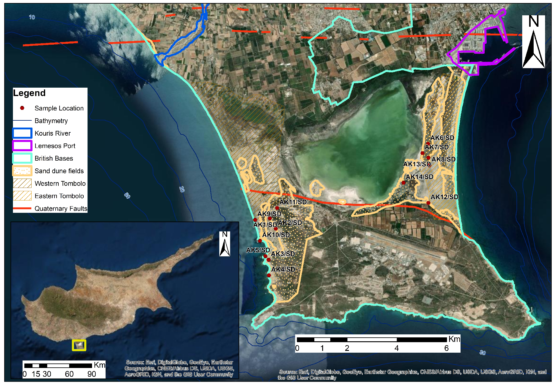
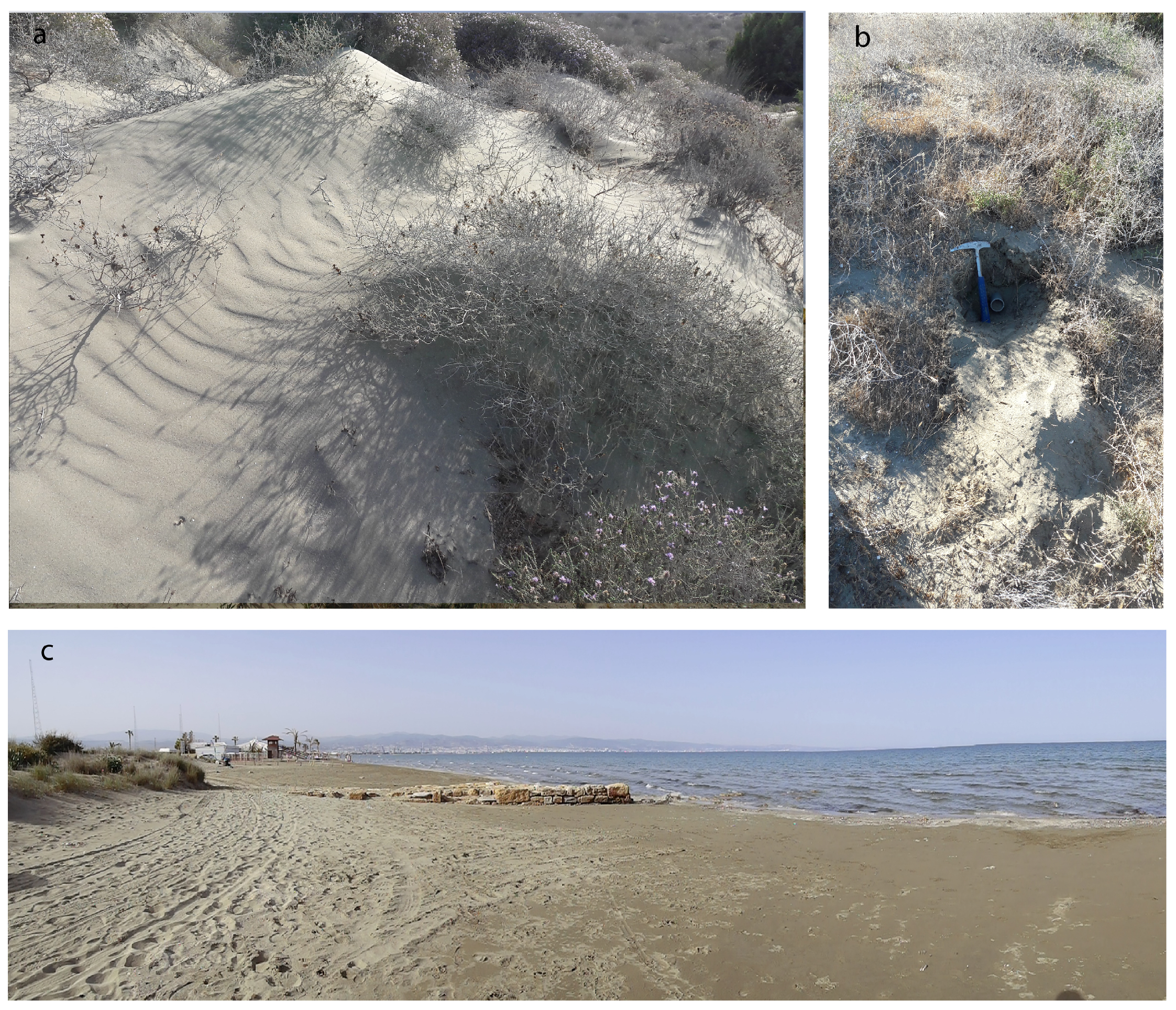
1.1. Study Area
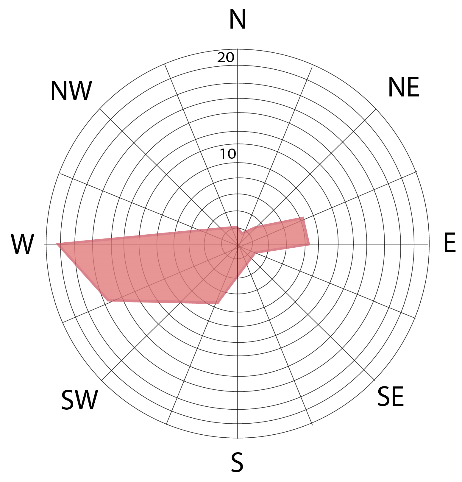
1.2. Climate
2. Material and Methods
2.1. Geochronology
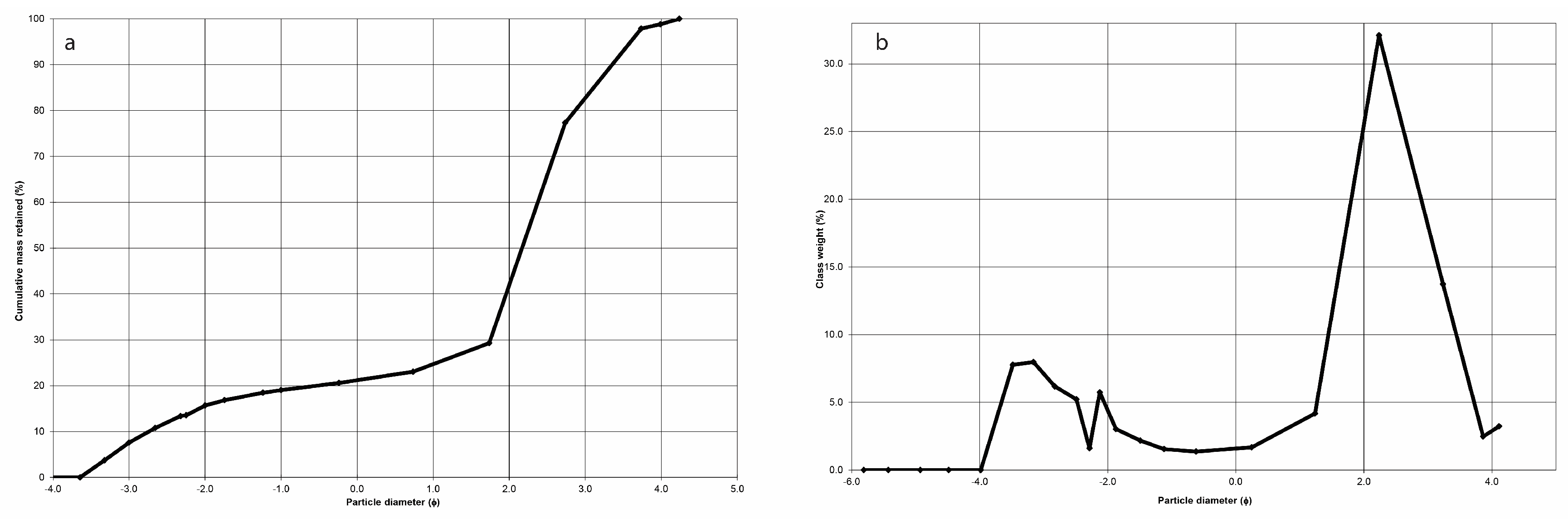
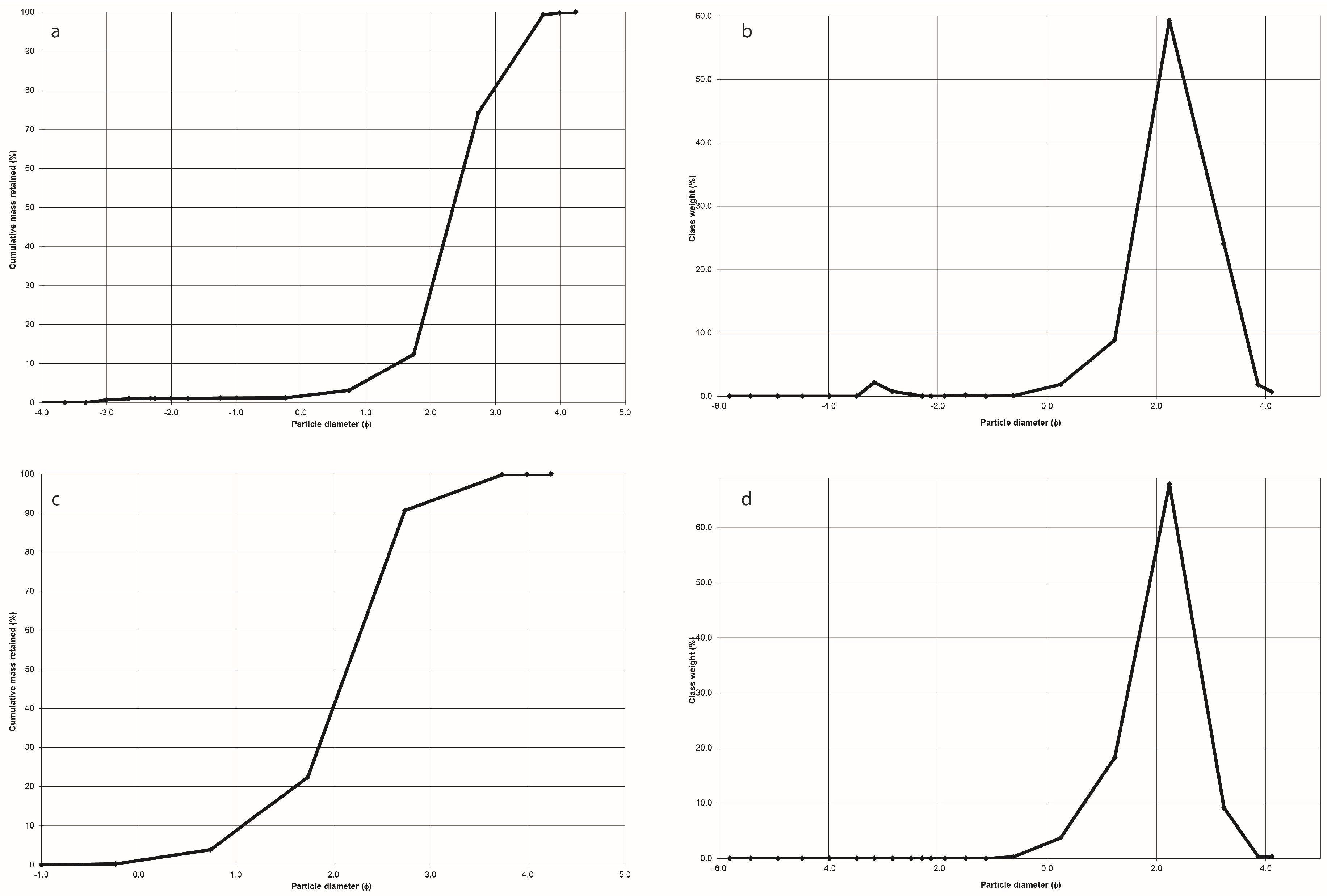
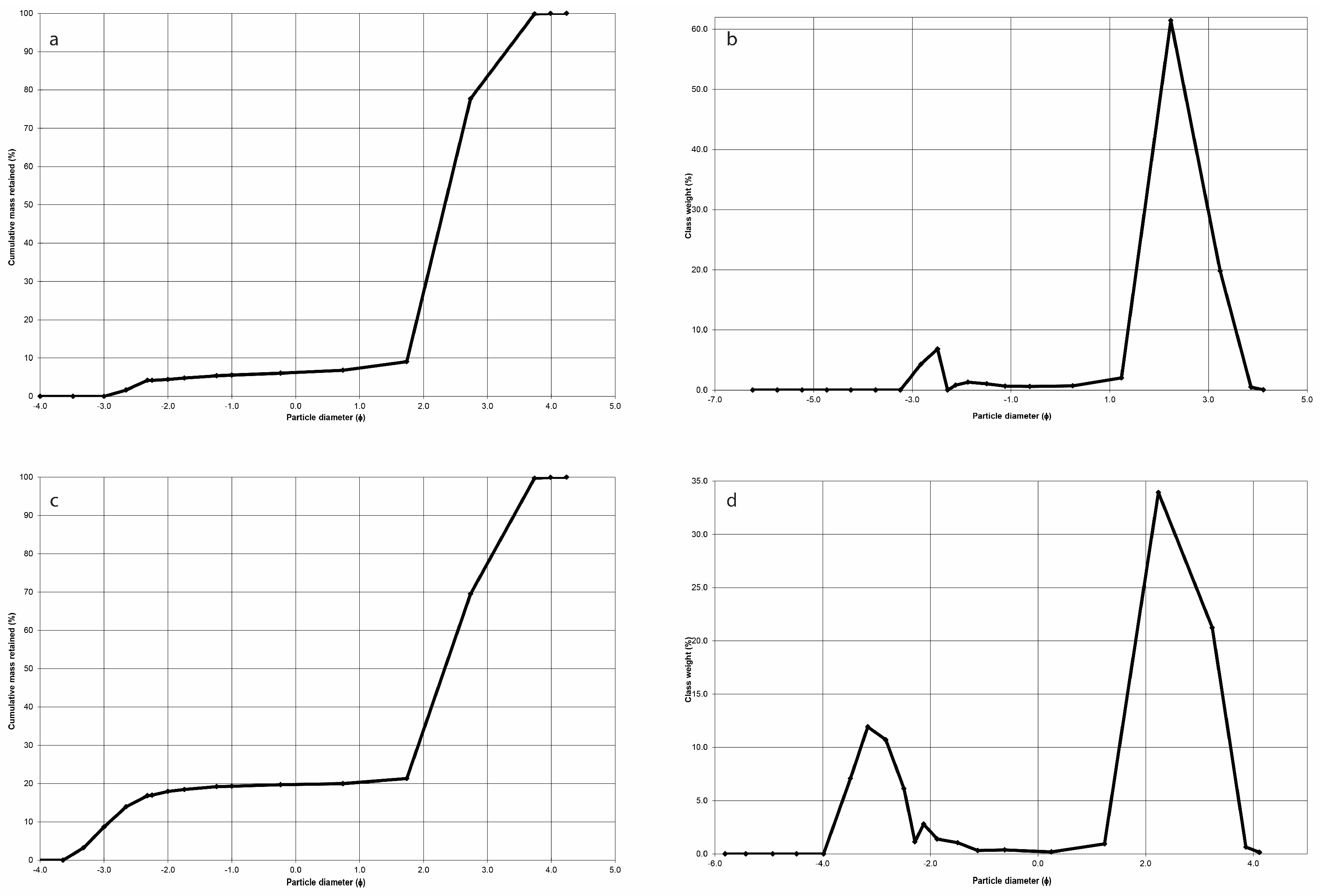
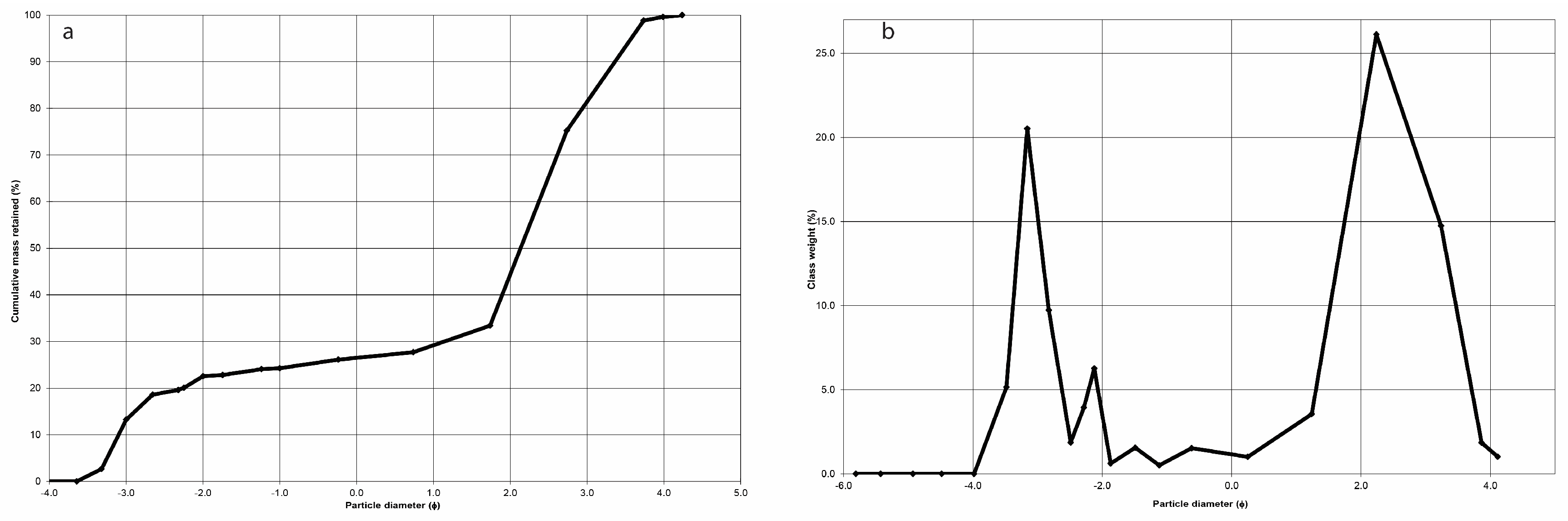
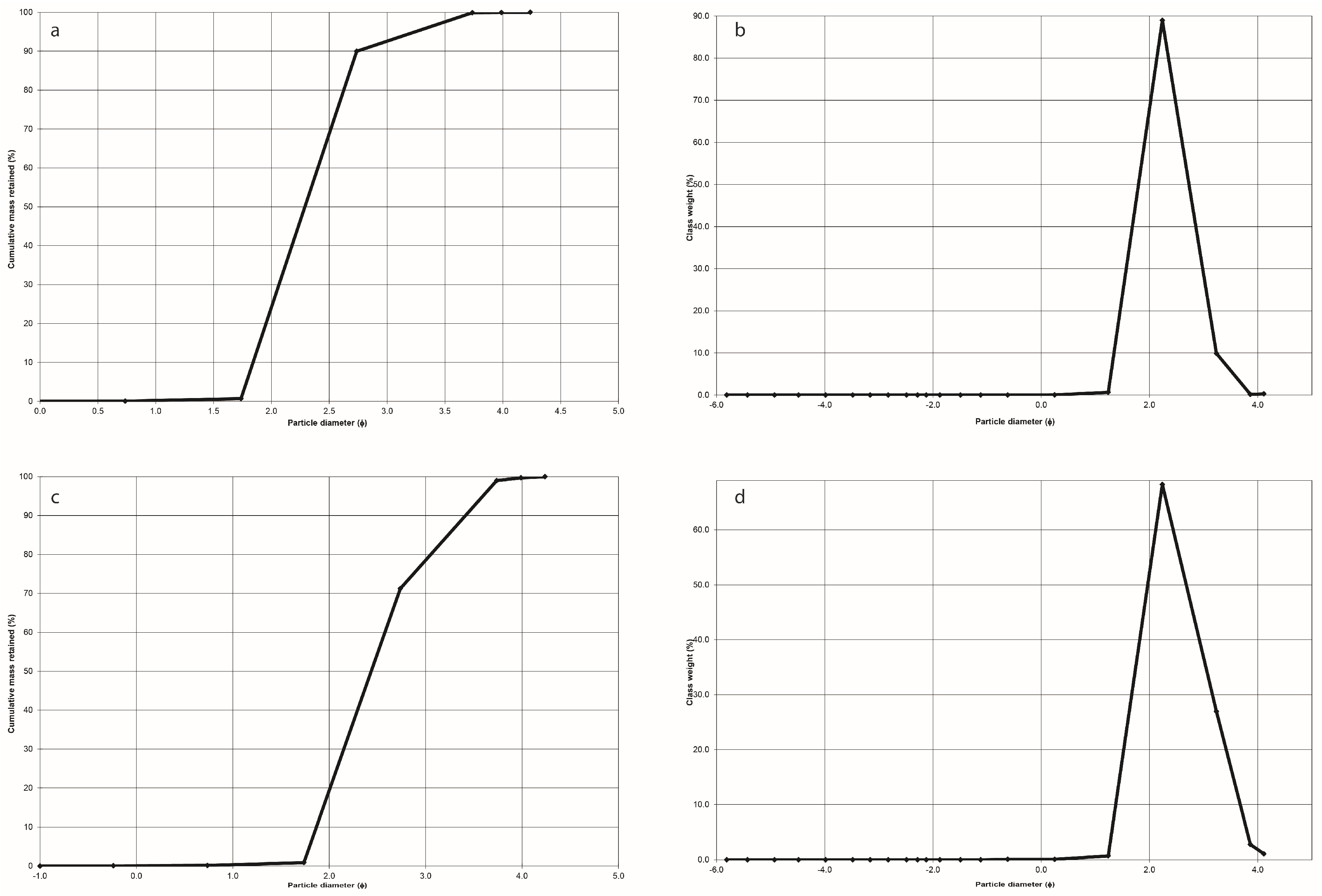
2.2. Grain Size Analysis
3. Results
3.1. Western Sand Dune Fields
3.2. Eastern Sand Dune Fields
3.3. OSL Measurements
4. Discussion
5. Conclusions
Author Contributions
Funding
Data Availability Statement
Acknowledgments
Conflicts of Interest
References
- Tsoar, H. Geomorphology and Paleogeography of Sand Dunes That Have Formed Thekurkar Ridges in the Coastal Plain of Israel. Isr. J. Earth Sci. 2000, 49, 189–196. [Google Scholar] [CrossRef]
- Aagaard, T.; Orford, J.; Murray, A.S. Environmental Controls on Coastal Dune Formation; Skallingen Spit, Denmark. Geomorphology 2007, 83, 29–47. [Google Scholar] [CrossRef]
- Costas, S.; Jerez, S.; Trigo, R.M.; Goble, R.; Rebêlo, L. Sand Invasion along the Portuguese Coast Forced by Westerly Shifts during Cold Climate Events. Quat. Sci. Rev. 2012, 42, 15–28. [Google Scholar] [CrossRef] [Green Version]
- Costas, S.; Naughton, F.; Goble, R.; Renssen, H. Windiness Spells in SW Europe since the Last Glacial Maximum. Earth Planet. Sci. Lett. 2016, 436, 82–92. [Google Scholar] [CrossRef]
- Delgado-Fernandez, I.; Davidson-Arnott, R. Meso-Scale Aeolian Sediment Input to Coastal Dunes: The Nature of Aeolian Transport Events. Geomorphology 2011, 126, 217–232. [Google Scholar] [CrossRef] [Green Version]
- Hesp, P.A.; Walker, I.J. Coastal dunes. In Treatise on Geomorphology; Elsevier Inc.: Amsterdam, The Netherlands, 2013; Volume 11, pp. 328–355. [Google Scholar] [CrossRef]
- Psuty, N.P.; Silveira, T.M. Global Climate Change: An Opportunity for Coastal Dunes? J. Coast. Conserv. 2010, 14, 153–160. [Google Scholar] [CrossRef]
- Pye, K. Coastal Dunes. Prog. Phys. Geogr. Earth Environ. 1983, 7, 531–557. [Google Scholar] [CrossRef]
- Feagin, R.A.; Sherman, D.J.; Grant, W.E. Coastal Erosion, Global Sea-Level Rise, and the Loss of Sand Dune Plant Habitats. Front. Ecol. Environ. 2005, 3, 359–364. [Google Scholar] [CrossRef]
- Miller, T.E.; Gornish, E.S.; Buckley, H.L. Climate and Coastal Dune Vegetation: Disturbance, Recovery, and Succession. Plant. Ecol. 2010, 206, 97–104. [Google Scholar] [CrossRef]
- Davidson-Arnott, R.; Law, M. Measurement and Prediction of Long-Term Sediment Supply to Coastal Foredunes. J. Coast. Res. 1996, 12, 654–663. [Google Scholar]
- Pye, K.; Blott, S.J. Evolution of a Sediment-Starved, over-Stabilised Dunefield: Kenfig Burrows, South Wales, UK. J. Coast. Conserv. 2017, 21, 685–717. [Google Scholar] [CrossRef]
- Shanahan, C.; Montoya, B.M. Erosion Reduction of Coastal Sands Using Microbial Induced Calcite Precipitation. Geo-Chicago 2016, 2016, 42–51. [Google Scholar] [CrossRef]
- Roelvink, D.; Reniers, A.; van Dongeren, A.; van Thiel de Vries, J.; McCall, R.; Lescinski, J. Modelling Storm Impacts on Beaches, Dunes and Barrier Islands. Coast. Eng. 2009, 56, 1133–1152. [Google Scholar] [CrossRef]
- Hallermeier, R.J.; Rhodes, P.E. Generic Treatment of Dune Erosion for 100-Year Event. Coast. Eng. 1989, 1988, 1197–1211. [Google Scholar] [CrossRef]
- Sherman, D.J.; Jackson, D.W.T.; Namikas, S.L.; Wang, J. Wind-Blown Sand on Beaches: An Evaluation of Models. Geomorphology 1998, 22, 113–133. [Google Scholar] [CrossRef]
- Sherman, D.J. Understanding Wind-Blown Sand: Six Vexations. Geomorphology 2020, 366, 107193. [Google Scholar] [CrossRef]
- Hoffmann, G.; Lampe, R.; Barnasch, J. Postglacial Evolution of Coastal Barriers along the West Pomeranian Coast, NE Germany. Quat. Int. 2005, 133–134 (Suppl. 1), 47–59. [Google Scholar] [CrossRef]
- Reimann, T.; Tsukamoto, S.; Harff, J.; Osadczuk, K.; Frechen, M. Reconstruction of Holocene Coastal Foredune Progradation Using Luminescence Dating—An Example from the Świna Barrier (Southern Baltic Sea, NW Poland). Geomorphology 2011, 132, 1–16. [Google Scholar] [CrossRef]
- Murray, A.S.; Wintle, A.G. Luminescence Dating of Quartz Using an Improved Single-Aliquot Regenerative-Dose Protocol. Radiat. Meas. 2000, 32, 57–73. [Google Scholar] [CrossRef]
- Cordier, S. Optically Stimulated Luminescence Dating: Procedures and Applications to Geomorphological Research in France. Geomorphologie 2010, 16, 21–40. [Google Scholar] [CrossRef] [Green Version]
- Del Valle, L.; Pomar, F.; Fornós, J.J.; Gómez-Pujol, L.; Timar-Gabor, A. Lower to Middle Pleistocene Coastal Dune Fields Formation in the Western Mediterranean (Western Eivissa, Balearic Archipelago): Chronology and Landscape Evolution. Aeolian Res. 2020, 45, 100595. [Google Scholar] [CrossRef]
- He, Z.; Zhou, J.; Lai, Z.P.; Yang, L.H.; Liang, J.M.; Long, H.; Ou, X.J. Quartz OSL Dating of Sand Dunes of Late Pleistocene in the Mu Us Desert in Northern China. Quat. Geochronol. 2010, 5, 102–106. [Google Scholar] [CrossRef]
- Peng, J.; Dong, Z.; Han, F. Optically Stimulated Luminescence Dating of Sandy Deposits from Gulang County at the Southern Margin of the Tengger Desert, China. J. Arid Land 2016, 8, 1–12. [Google Scholar] [CrossRef] [Green Version]
- Ning, W.X.; Wang, Z.T. Pattern Analysis and Dating for the Badain Jaran Dune Field, Northwestern China. Environ. Earth Sci. 2020, 79, 1–11. [Google Scholar] [CrossRef]
- Hadjichambis, A.C.; Paraskeva-Hadjichambi, D.; Dimopoulos, P.; Hadjichambis, A.C.; Della, A.; Paraskeva-Hadjichambi, D.; Georghiou, K.; Dimopoulos, P. Flora of the Sand Dune Ecosystems of Cyprus European Network for Environmental Citizenship View Project Vegetation of Europe View Project Flora of the Sand Dune Ecosystems of Cyprus. 2004. Available online: https://www.semanticscholar.org/paper/Flora-of-the-sand-dune-ecosystems-of-Cyprus-Hadjichambis-Della/53d46e610c2b5ccecb3920e8cd846c210c884af4 (accessed on 29 October 2021).
- Della, A.; Iatrou, G. New Plant Records from Cyprus. Kew Bull. 1996, 50, 387–396. [Google Scholar] [CrossRef]
- Loizides, M.; Carbone, M.; Alvarado, P. Geoglossum Dunense (Ascomycota, Geoglossales): A New Species from the Mediterranean Islands of Cyprus and Malta. Mycol. Prog. 2015, 14, 1–8. [Google Scholar] [CrossRef]
- Zomeni, Z. Quaternary Marine Terraces on Cyprus: Constraints on Uplift and Pedogenesis, and the Geoarchaeology of Palaipafos. Ph.D. Thesis, Oregon State University, Corvallis, OR, USA, 2012. [Google Scholar]
- Polidorou, M.; Saitis, G.; Evelpidou, N. Beachrock Development as an Indicator of Paleogeographic Evolution, the Case of Akrotiri Peninsula, Cyprus. Z. Geomorphol. 2021, 3–17. [Google Scholar] [CrossRef]
- Polidorou, M.; Evelpidou, N.; Tsourou, T.; Drinia, H.; Salomon, F.; Blue, L. Observations on Palaeogeographical Evolution of Akrotiri Salt Lake, Lemesos, Cyprus. Geosciences 2021, 11, 321. [Google Scholar] [CrossRef]
- Milnes, E. Process-Based Groundwater Salinisation Risk Assessment Methodology: Application to the Akrotiri Aquifer (Southern Cyprus). J. Hydrol. 2011, 399, 29–47. [Google Scholar] [CrossRef] [Green Version]
- Bear, L.; Morel, S. The Geology and Mineral Resources of the Agros-Akrotiri Area; Cyprus Geological Survey Department: Nicosia, Cyprus, 1960.
- Garzanti, E.; Andò, S.; Scutellà, M. Actualistic Ophiolite Provenance: The Cyprus Case. J. Geol. 2000, 108, 199–218. [Google Scholar] [CrossRef]
- Zavatarielli, M.; Mellor, L.G. A Numerical Study of the Mediterranean Sea Circulation. J. Phys. Oceanogr. 1995, 25, 1384–1414. [Google Scholar] [CrossRef] [Green Version]
- Saaroni, H.; Halfon, N.; Ziv, B.; Alpert, P.; Kutiel, H. Links between the Rainfall Regime in Israel and Location and Intensity of Cyprus Lows. Int. J. Climatol. 2010, 30, 1014–1025. [Google Scholar] [CrossRef]
- Rojas, R.; Feyen, L.; Watkiss, P. Climate Change and River Floods in the European Union: Socio-Economic Consequences and the Costs and Benefits of Adaptation. Glob. Environ. Chang. 2013, 23, 1737–1751. [Google Scholar] [CrossRef]
- Zodiatis, G.; Drakopoulos, P.; Brenner, S.; Groom, S. Variability of the Cyprus Warm Core Eddy during the CYCLOPS Project. Deep Sea Res. Part II Top. Stud. Oceanogr. 2005, 52, 2897–2910. [Google Scholar] [CrossRef]
- Menna, M.; Poulain, P.M.; Zodiatis, G.; Gertman, I. On the Surface Circulation of the Levantine Sub-Basin Derived from Lagrangian Drifters and Satellite Altimetry Data. Deep Sea Res. Part I Oceanogr. Res. Pap. 2012, 65, 46–58. [Google Scholar] [CrossRef]
- Goldsmith, V.; Rosen, P.; Gertner, Y. Eolian transport measurements, winds, and comparison with theoretical transport in Israeli coastal dunes. In Coastal Dunes. Form and Process; Wiley: Chichester, UK, 1990. [Google Scholar]
- Tsoar, H. Trends in the Development of Sand Dunes along the Southeastern Mediterranean Coast in Dunes of the European Coasts. Geomorphology–Hydrology–Soils. Catena. Suppl. 1990, 18, 51–60. [Google Scholar]
- Tsoar, H.; Blumberg, D.G. Formation of Parabolic Dunes from Barchan and Transverse Dunes along Israel’s Mediterranean Coast. Earth Surf. Process. Landforms 2002, 27, 1147–1161. [Google Scholar] [CrossRef]
- Tsoar, H. Sand Dunes Mobility and Stability in Relation to Climate. Phys. A Stat. Mech. Its Appl. 2005, 357, 50–56. [Google Scholar] [CrossRef]
- Schilman, B.; Bar-Matthews, M.; Almogi-Labin, A.; Luz, B. Global Climate Instability Reflected by Eastern Mediterranean Marine Records during the Late Holocene. Palaeogeogr. Palaeoclimatol. Palaeoecol. 2001, 176, 157–176. [Google Scholar] [CrossRef]
- Indermühle, A.; Stocker, T.F.; Joos, F.; Fischer, H.; Smith, H.J.; Wahlen, M.; Deck, B.; Mastroianni, D.; Tschumi, J.; Blunier, T.; et al. Holocene Carbon-Cycle Dynamics Based on CO2 Trapped in Ice at Taylor Dome, Antarctica. Nature 1999, 398, 121–126. [Google Scholar] [CrossRef]
- Lückge, A.; Doose-Rolinski, H.; Khan, A.A.; Schulz, H.; Von Rad, U. Monsoonal Variability in the Northeastern Arabian Sea during the Past 5000 Years: Geochemical Evidence from Laminated Sediments. Palaeogeogr. Palaeoclimatol. Palaeoecol. 2001, 167, 273–286. [Google Scholar] [CrossRef]
- Preusser, F.; Degering, D.; Fuchs, M.; Hilgers, A.; Kadereit, A.; Klasen, N.; Krbetschek, M.; Richter, D.; Spencer, J.Q.G. Luminescence Dating: Basics, Methods and Applications. E G Quat. Sci. J. 2008, 57, 95–149. [Google Scholar] [CrossRef] [Green Version]
- Folk, R.L. The Distinction between Grain Size and Mineral Composition in Sedimentary-Rock Nomenclature. J. Geol. 1954, 62, 344–359. [Google Scholar] [CrossRef]
- Blott, S.J.; Pye, K. GRADISTAT: A Grain Size Distribution and Statistics Package for the Analysis of Unconsolidated Sediments. Earth Surf. Process. Landforms 2001, 26, 1237–1248. [Google Scholar] [CrossRef]
- El Banna, M.M. Nature and Human Impact on Nile Delta Coastal Sand Dunes, Egypt. Environ. Geol. 2003, 45, 690–695. [Google Scholar] [CrossRef]
- Tsakalos, E.; Christodoulakis, J.; Charalambous, L. The Dose Rate Calculator (DRc) for Luminescence and ESR Dating-a Java Application for Dose Rate and Age Determination. Archaeometry 2016, 58, 347–352. [Google Scholar] [CrossRef]
- Galbraith, R.F.; Roberts, R.G.; Laslett, G.M.; Yoshida, H.; Olley, J.M. Optical Dating of Single and Multiple Grains of Quartz from Jinmium Rock Shelter, Northern Australia: Part I, Experimental Design and Statistical Models. Archaeometry 1999, 41, 339–364. [Google Scholar] [CrossRef]
- Stone, A.E.C.; Thomas, D.S.G. Linear Dune Accumulation Chronologies from the Southwest Kalahari, Namibia: Challenges of Reconstructing Late Quaternary Palaeoenvironments from Aeolian Landforms. Quat. Sci. Rev. 2008, 27, 1667–1681. [Google Scholar] [CrossRef]
- Telfer, M.W.; Bailey, R.M.; Burrough, S.L.; Stone, A.E.S.; Thomas, D.S.G.; Wiggs, G.S.F. Understanding Linear Dune Chronologies: Insights from a Simple Accumulation Model. Geomorphology 2010, 120, 195–208. [Google Scholar] [CrossRef]
- Roskin, J.; Tsoar, H.; Porat, N.; Blumberg, D.G. Palaeoclimate Interpretations of Late Pleistocene Vegetated Linear Dune Mobilization Episodes: Evidence from the Northwestern Negev Dunefield, Israel. Quat. Sci. Rev. 2011, 30, 3364–3380. [Google Scholar] [CrossRef]
- Thomas, D.S.G.; Bailey, R.M. Is There Evidence for Global-Scale Forcing of Southern Hemisphere Quaternary Desert Dune Accumulation? A Quantitative Method for Testing Hypotheses of Dune System Development. Earth Surf. Process. Landforms 2017, 42, 2280–2294. [Google Scholar] [CrossRef]
- Mcgee, D.; Broecker, W.S.; Winckler, G. Gustiness: The Driver of Glacial Dustiness? Quat. Sci. Rev. 2010. [Google Scholar] [CrossRef]
- Poole, A.; Robertson, A. Pleistocene Fanglomerate Deposition Related to Uplift of the Troodos Ophiolite, Cyprus. Proc. Ocean Drill. Progr. Sci. Results 1998, 160, 545–568. [Google Scholar] [CrossRef]
- Roskin, J.; Katra, I.; Porat, N.; Zilberman, E. Evolution of Middle to Late Pleistocene Sandy Calcareous Paleosols Underlying the Northwestern Negev Desert Dunefield (Israel). Palaeogeogr. Palaeoclimatol. Palaeoecol. 2013, 387, 134–152. [Google Scholar] [CrossRef]
- Roskin, J.; Bookman, R.; Friesem, D.E.; Vardi, J. A Late Pleistocene Linear Dune Dam Record of Aeolian-Fluvial Dynamics at the Fringes of the Northwestern Negev Dunefield. Sediment. Geol. 2017, 353, 76–95. [Google Scholar] [CrossRef]
- Vaks, A.; Bar-Matthews, M.; Ayalon, A.; Matthews, A.; Frumkin, A.; Dayan, U.; Halicz, L.; Almogi-Labin, A.; Schilman, B. Paleoclimate and Location of the Border between Mediterranean Climate Region and the Saharo–Arabian Desert as Revealed by Speleothems from the Northern Negev Desert, Israel. Earth Planet. Sci. Lett. 2006, 249, 384–399. [Google Scholar] [CrossRef]
- Liu, B.; Coulthard, T.J. Mapping the Interactions between Rivers and Sand Dunes: Implications for Fluvial and Aeolian Geomorphology. Geomorphology 2015, 231, 246–257. [Google Scholar] [CrossRef]
- Robins, L.; Greenbaum, N.; Yu, L.P.; Bookman, R.; Roskin, J. High-Resolution Portable-OSL Analysis of Vegetated Linear Dune Construction in the Margins of the Northwestern Negev Dunefield (Israel) during the Late Quaternary. Aeolian Res. 2021, 50, 100680. [Google Scholar] [CrossRef]
- Robins, L.; Roskin, J.; Yu, L.; Greenbaum, N. Aeolian-Fluvial Sediments and Landscapes along the Northwestern Negev Dunefield (Israel) Margins since the Late Pleistocene. In Proceedings of the 23rd EGU General Assembly, Online, 19–30 April 2021. [Google Scholar]
- Tsakalos, E. Geochronology and Exoscopy of Quartz Grains in Environmental Determination of Coastal Sand Dunes in SE Cyprus. J. Archaeol. Sci. Rep. 2016, 7, 679–686. [Google Scholar] [CrossRef]
- Athanassas, C.; Zacharias, N. Recuperated-OSL Dating of Quartz from Aegean (South Greece) Raised Pleistocene Marine Sediments: Current Results. Quat. Geochronol. 2010, 5, 65–75. [Google Scholar] [CrossRef]
- Elmejdoub, N.; Mauz, B.; Jedoui, Y. Sea-Level and Climatic Controls on Late Pleistocene Coastal Aeolianites in the Cap Bon Peninsula, Northeastern Tunisia. Boreas 2011, 40, 198–207. [Google Scholar] [CrossRef]
- Mellett, C.L.; Hodgson, D.M.; Lang, A.; Mauz, B.; Selby, I.; Plater, A.J. Preservation of a Drowned Gravel Barrier Complex: A Landscape Evolution Study from the North-Eastern English Channel. Mar. Geol. 2012, 315–318, 115–131. [Google Scholar] [CrossRef]
- Brooke, B. The Distribution of Carbonate Eolianite. Earth Sci. Rev. 2001, 55, 135–164. [Google Scholar] [CrossRef]
- Thom, B.G.; Bowman, G.M.; Roy, P.S. Late Quaternary Evolution of Coastal Sand Barriers, Port Stephens-Myall Lakes Area, Central New South Wales, Australia. Quat. Res. 1981, 15, 345–364. [Google Scholar] [CrossRef]
- Murray-Wallace, C.V.; Bourman, R.P.; Prescott, J.R.; Williams, F.; Price, D.M.; Belperio, A.P. Aminostratigraphy and Thermoluminescence Dating of Coastal Aeolianites and the Later Quaternary History of a Failed Delta: The River Murray Mouth Region, South Australia. Quat. Geochronol. 2010, 5, 28–49. [Google Scholar] [CrossRef]
- Hearty, P.J.; O’Leary, M.J. Carbonate Eolianites, Quartz Sands, and Quaternary Sea-Level Cycles, Western Australia: A Chronostratigraphic Approach. Quat. Geochronol. 2008, 3, 26–55. [Google Scholar] [CrossRef] [Green Version]
- Soulas, J.P. Active Tectonics Studies in Cyprus for Seismic Risk Mitigation: The Greater Limassol Area; Cyprus Geological Survey Department: Nicosia, Cyprus, 1999.
- Mauz, B.; Hijma, M.P.; Amorosi, A.; Porat, N.; Galili, E.; Bloemendal, J. Aeolian Beach Ridges and Their Significance for Climate and Sea Level: Concept and Insight from the Levant Coast (East Mediterranean). Earth Sci. Rev. 2013, 121, 31–54. [Google Scholar] [CrossRef]


| Sample ID | Location | Type of Analysis | Distance from the Coast (m) | Elevation (m) | Humidity (%) |
|---|---|---|---|---|---|
| AK1/SD | West | Grain Size + OSL | 498 | 1.56 | 0.65 |
| AK2/SD | West | OSL | 682 | 1.72 | 0.82 |
| AK3/SD | West | Not Qualified | 137 | 1.98 | n/a |
| AK4/SD | West | Not Qualified | 25.3 | 0.64 | n/a |
| AK5/SD | West | Grain size + OSL | 52.5 | 1.04 | 2.69 |
| AK6/SD | East | OSL | 1135 | 0.34 | 1.74 |
| AK7/SD | East | Not Qualified | 1331.4 | 0.21 | n/a |
| AK8/SD | East | Not Qualified | 1084.7 | 0.47 | n/a |
| AK9/SD | West | Grain size | 17.67 | 1.08 | 2.05 |
| AK10/SD | West | Grain size | 13.69 | 2.13 | 0.97 |
| AK11/SD | West | Grain size | 870 | 12.17 | 0.71 |
| AK12/SD | East | Grain size | 963.76 | 2.56 | 1.98 |
| AK13/SD | East | Grain size | 1733 | 0.54 | 0.42 |
| AK14/SD | East | Grain size | 116.85 | 0.57 | 0.56 |
| Sample ID | De (Gy) | DR (Gy/ka) | Age (ka) |
|---|---|---|---|
| AK 1/SD | 23.7 ± 1.9 | 0.588 ± 0.04 | 40.3 ± 4.2 |
| AK 2/SD | 32.6 ± 2.3 | 0.569 ± 0.039 | 56.2 ± 5.5 |
| AK 5/SD | 22.0 ± 2.3 | 0.562 ± 0.039 | 39.2 ± 4.9 |
| AK 6/SD | NO RESULT | 0.520 ± 0.038 | NO RESULT |
Publisher’s Note: MDPI stays neutral with regard to jurisdictional claims in published maps and institutional affiliations. |
© 2021 by the authors. Licensee MDPI, Basel, Switzerland. This article is an open access article distributed under the terms and conditions of the Creative Commons Attribution (CC BY) license (https://creativecommons.org/licenses/by/4.0/).
Share and Cite
Polidorou, M.; Evelpidou, N. Geomorphology of the Coastal Sand Dune Fields and Their Association with the Palaeolandscape Evolution of Akrotiri Peninsula, Lemesos, Cyprus. Geosciences 2021, 11, 448. https://doi.org/10.3390/geosciences11110448
Polidorou M, Evelpidou N. Geomorphology of the Coastal Sand Dune Fields and Their Association with the Palaeolandscape Evolution of Akrotiri Peninsula, Lemesos, Cyprus. Geosciences. 2021; 11(11):448. https://doi.org/10.3390/geosciences11110448
Chicago/Turabian StylePolidorou, Miltiadis, and Niki Evelpidou. 2021. "Geomorphology of the Coastal Sand Dune Fields and Their Association with the Palaeolandscape Evolution of Akrotiri Peninsula, Lemesos, Cyprus" Geosciences 11, no. 11: 448. https://doi.org/10.3390/geosciences11110448
APA StylePolidorou, M., & Evelpidou, N. (2021). Geomorphology of the Coastal Sand Dune Fields and Their Association with the Palaeolandscape Evolution of Akrotiri Peninsula, Lemesos, Cyprus. Geosciences, 11(11), 448. https://doi.org/10.3390/geosciences11110448