Global High-Resolution Magnetic Field Inversion Using Spherical Harmonic Representation of Tesseroids as Individual Sources


Abstract
1. Introduction
2. Methodology
2.1. Tesseroid Forward Field
2.2. Spherical Harmonic Model
2.3. Projected Gradient Inversion
3. Data
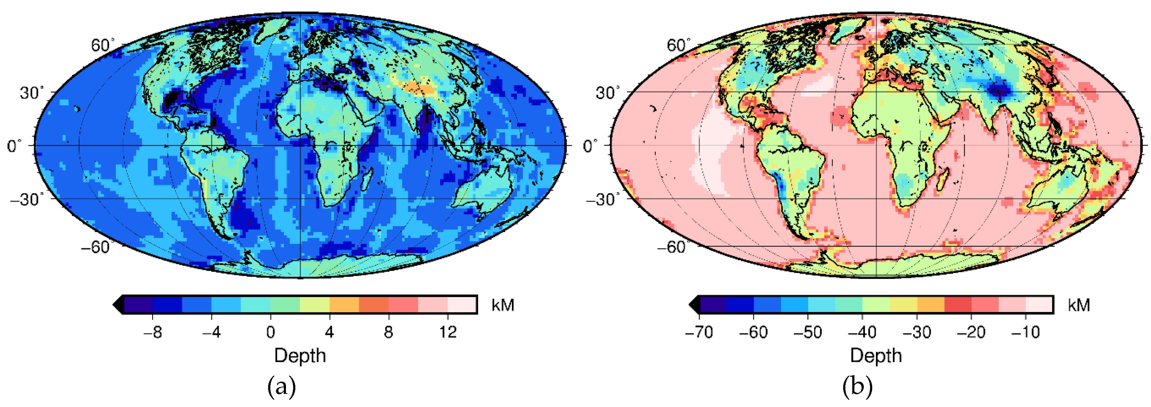
3.1. Model Geometry
3.2. Magnetization Direction and Susceptibility
3.3. Lithospheric Magnetic Field Models
3.3.1. LCS-1
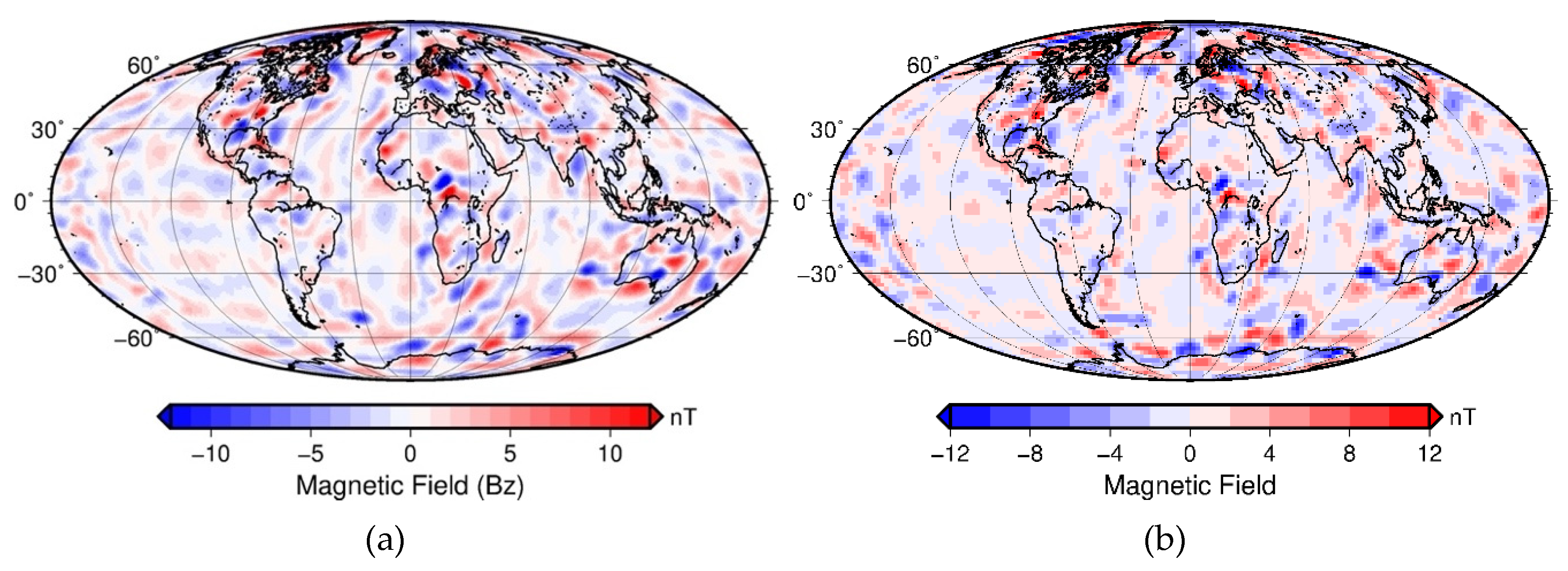
3.3.2. Synthetic Observed Field
4. Results
4.1. Synthetic Test
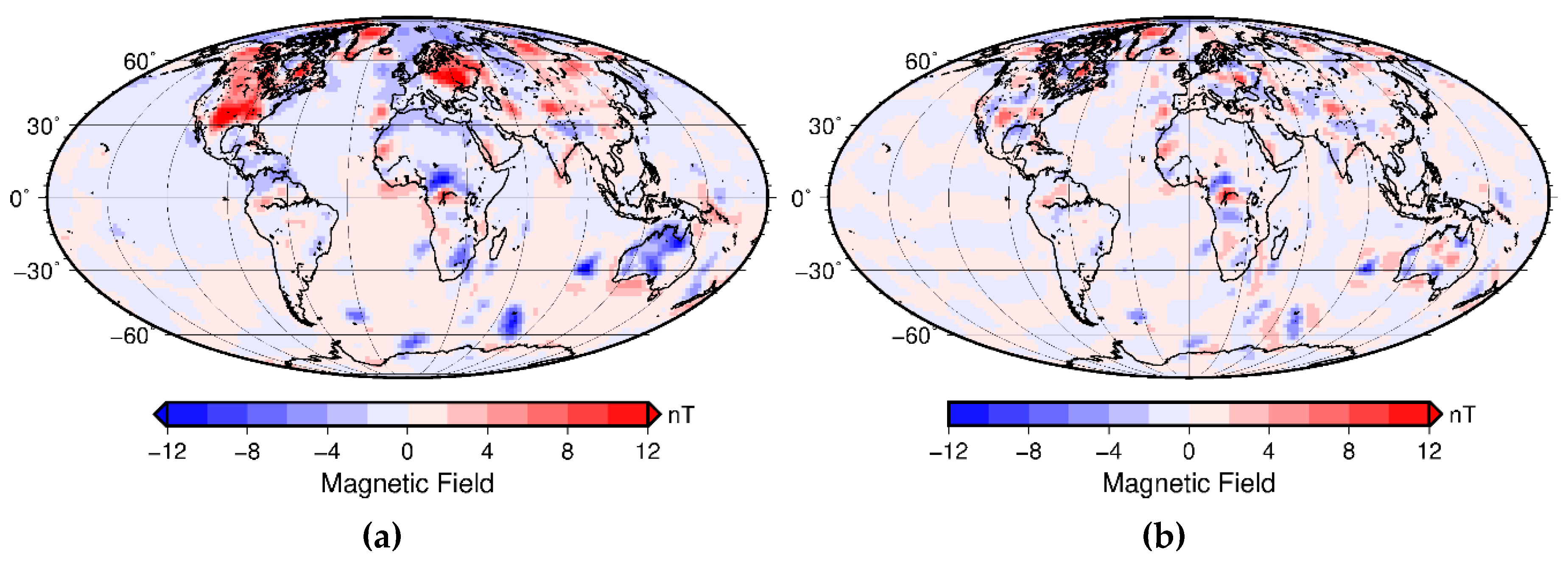
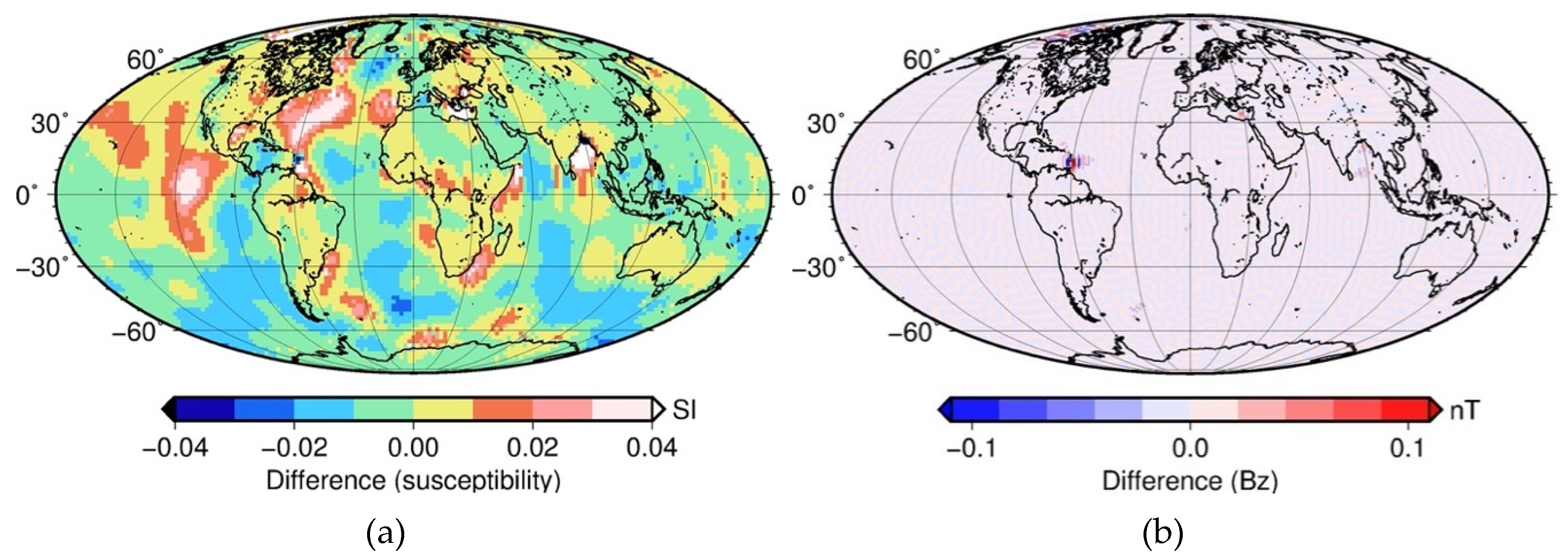
4.1.1. A-Priori Model from a True Susceptibility Model
4.1.2. Initial Guess with Averaged Susceptibility for Oceanic and Continental Crust
4.2. Inversion of LCS-1
5. Discussion
5.1. Performance of Inversion
5.2. Use of a-Priori Model
5.3. Layering of the Model
5.4. Regularization
5.5. Application to Airborne Data—Proof of Concept
6. Conclusions
Author Contributions
Funding
Acknowledgments
Conflicts of Interest
References
- Langel, R.; Hinze, W.J. The Magnetic Field of the Earth’s Lithosphere; Cambridge University Press: Cambridge, UK, 1998. [Google Scholar]
- Müller, R.D.; Sdrolias, M.; Gaina, C.; Roest, W.R. Age, spreading rates, and spreading asymmetry of the world’s ocean crust. Geochem. Geophys. Geosyst. 2008, 9. [Google Scholar] [CrossRef]
- Maus, S. Magnetic Field Model MF7. 2010. Available online: http://www.geomag.us/models/MF7.html (accessed on 1 March 2020).
- Olsen, N.; Ravat, D.; Finlay, C.C.; Kother, L.K. LCS-1: A high-resolution global model of the lithospheric magnetic field derived from CHAMP and Swarm satellite observations. Geophys. J. Int. 2017, 211, 1461–1477. [Google Scholar] [CrossRef]
- Kotsiaros, S.; Olsen, N. End-to-End simulation study of a full magnetic gradiometry mission. Geophys. J. Int. 2014, 196, 100–110. [Google Scholar] [CrossRef]
- Thébault, E. Global lithospheric magnetic field modelling by successive regional analysis. Earth Planets Space 2006, 58, 485–495. [Google Scholar] [CrossRef]
- Thébault, E.; Vigneron, P.; Maus, S.; Chulliat, A.; Sirol, O.; Hulot, G. Swarm SCARF Dedicated Lithospheric Field Inversion chain. Earth Planets Space 2013, 65, 7. [Google Scholar] [CrossRef]
- Meyer, J.; Hufen, J.-H.; Siebert, M.; Hahn, A. Investigations of the internal geomagnetic field by means of a global model of the earth’s crust. J. Geophys. Z. Geophys. 1983, 52, 71–84. [Google Scholar]
- Hahn, A.; Ahrendt, H.; Meyer, J.; Hufen, J.H. A model of magnetic sources within the Earth’s crust compatible with the field measured by the satellite Magsat. Geologisches Jahrbuch 1984, 75, 125–156. [Google Scholar]
- Langel, R.; Ousley, G.; Berbert, J.; Murphy, J.; Settle, M. The MAGSAT mission. Geophys. Res. Lett. 1982, 9, 243–245. [Google Scholar] [CrossRef]
- Purucker, M.; Langel, R.; Rajaram, M.; Raymond, C. Global magnetization models with a priori information. J. Geophys. Res. Solid Earth 1998, 103, 2563–2584. [Google Scholar] [CrossRef]
- Nataf, H.-C.; Ricard, Y. 3SMAC: An a priori tomographic model of the upper mantle based on geophysical modeling. Phys. Earth Planet. Inter. 1996, 95, 101–122. [Google Scholar] [CrossRef]
- Dyment, J.; Arkani-Hamed, J. Contribution of lithospheric remanent magnetization to satellite magnetic anomalies over the world’s oceans. J. Geophys. Res. Solid Earth 1998, 103, 15423–15441. [Google Scholar] [CrossRef]
- Purucker, M.; Langlais, B.; Olsen, N.; Hulot, G.; Mandea, M. The southern edge of cratonic North America: Evidence from new satellite magnetometer observations. Geophys. Res. Lett. 2002, 29, 56-1–56-4. [Google Scholar] [CrossRef]
- Hemant, K. Modelling and Interpretation of Global Lithospheric Magnetic Anomalies. Ph.D. Thesis, Deutsches GeoForschungsZentrum GFZ, Potsdam, Germany, 2003. [Google Scholar]
- Hemant, K.; Maus, S. Geological modeling of the new CHAMP magnetic anomaly maps using a geographical information system technique. J. Geophys. Res. Solid Earth 2005, 110, B12103. [Google Scholar] [CrossRef]
- Masterton, S.M.; Gubbins, D.; Müller, R.D.; Singh, K.H. Forward modelling of oceanic lithospheric magnetization. Geophys. J. Int. 2013, 192, 951–962. [Google Scholar] [CrossRef]
- Lesur, V.; Jackson, A. Exact solutions for internally induced magnetization in a shell. Geophys. J. Int. 2000, 140, 453–459. [Google Scholar] [CrossRef]
- Lesur, V.; Vervelidou, F. Retrieving lithospheric magnetization distribution from magnetic field models. Geophys. J. Int. 2019, 220, 981–995. [Google Scholar] [CrossRef]
- Maus, S.; Haak, V. Magnetic field annihilators: Invisible magnetization at the magnetic equator. Geophys. J. Int. 2003, 155, 509–513. [Google Scholar] [CrossRef]
- Götze, H.-J.; Lahmeyer, B. Application of three-dimensional interactive modeling in gravity and magnetics. Geophysics 1988, 53, 1096–1108. [Google Scholar] [CrossRef]
- Baykiev, E.; Ebbing, J.; Brönner, M.; Fabian, K. Forward modeling magnetic fields of induced and remanent magnetization in the lithosphere using tesseroids. Comput. Geosci. 2016, 96, 124–135. [Google Scholar] [CrossRef]
- Wieczorek, M.A.; Meschede, M. SHTools: Tools for Working with Spherical Harmonics. Geochem. Geophys. Geosyst. 2018, 19, 2574–2592. [Google Scholar] [CrossRef]
- Driscoll, J.R.; Healy, D.M. Computing Fourier Transforms and Convolutions on the 2-Sphere. Adv. Appl. Math. 1994, 15, 202–250. [Google Scholar] [CrossRef]
- Lin, C. Projected Gradient Methods for Nonnegative Matrix Factorization. Neural Comput. 2007, 19, 2756–2779. [Google Scholar] [CrossRef] [PubMed]
- Laske, G.; Masters, G.; Ma, Z.; Pasyanos, M. Update on CRUST1.0—A 1-Degree Global Model of Earth’s Crust. In Geophysical Research Abstracts; EGU General Assembly: Vienna, Austria, 2013; Volume 15. [Google Scholar]
- Szwillus, W.; Afonso, J.C.; Ebbing, J.; Mooney, W.D. Global Crustal Thickness and Velocity Structure from Geostatistical Analysis of Seismic Data. J. Geophys. Res. Solid Earth 2019, 124, 1626–1652. [Google Scholar] [CrossRef]
- Thébault, E.; Finlay, C.C.; Beggan, C.D.; Alken, P.; Aubert, J.; Barrois, O.; Bertrand, F.; Bondar, T.; Boness, A.; Brocco, L.; et al. International Geomagnetic Reference Field: The 12th generation. Earth Planets Space 2015, 67, 79. [Google Scholar] [CrossRef]
- Vervelidou, F.; Lesur, V. Unveiling Earth’s Hidden Magnetization. Geophys. Res. Lett. 2018, 45, 12283–12292. [Google Scholar] [CrossRef]
- Olesen, O.; Brönner, M.; Ebbing, J.; Gellein, J.; Gernigon, L.; Koziel, J.; Lauritsen, T.; Myklebust, R.; Pascal, C.; Sand, M.; et al. New aeromagnetic and gravity compilations from Norway and adjacent areas: Methods and applications. In Geological Society, London, Petroleum Geology Conference Series; Geological Society of London: London, UK, 2010; Volume 7, pp. 559–586. [Google Scholar]
- Korhonen, J.V.; Aaro, S.; All, T.; Nevanlinna, H.; Skilbrei, J.R.; Säävuori, H.; Vaher, R.; Zhdanova, L.; Koistinen, T. Magnetic Anomaly Map of the Fennoscandian Shield 1: 2 000 000; Geological Surveys of Finland, Norway and Sweden and Ministry of Natural Resources of Russian Federation: 2002. Available online: https://www.researchgate.net/publication/228566513_Preliminary_magnetic_and_gravity_anomaly_maps_of_the_Fennoscandian_shield_1_10_000_000 (accessed on 1 March 2020).
- Enkin, R.J.; Hamilton, T.S.; Morris, W.A. The Henkel Petrophysical Plot: Mineralogy and Lithology from Physical Properties. Geochem. Geophys. Geosyst. 2020, 21, e2019GC008818. [Google Scholar] [CrossRef]
- Idoko, C.M.; Conder, J.A.; Ferré, E.C.; Filiberto, J. The potential contribution to long wavelength magnetic anomalies from the lithospheric mantle. Phys. Earth Planet. Inter. 2019, 292, 21–28. [Google Scholar] [CrossRef]
- Thébault, E.; Vervelidou, F. A statistical spatial power spectrum of the Earth’s lithospheric magnetic field. Geophys. J. Int. 2015, 201, 605–620. [Google Scholar] [CrossRef]
- Ravat, D.; Wang, B.; Wildermuth, E.; Taylor, P.T. Gradients in the interpretation of satellite-altitude magnetic data: An example from central Africa. J. Geodyn. 2002, 33, 131–142. [Google Scholar] [CrossRef]
- Fullea, J.; Afonso, J.C.; Connolly, J.A.D.; Fernàndez, M.; García-Castellanos, D.; Zeyen, H. LitMod3D: An interactive 3-D software to model the thermal, compositional, density, seismological, and rheological structure of the lithosphere and sublithospheric upper mantle. Geochem. Geophys. Geosyst. 2009, 10. [Google Scholar] [CrossRef]


© 2020 by the authors. Licensee MDPI, Basel, Switzerland. This article is an open access article distributed under the terms and conditions of the Creative Commons Attribution (CC BY) license (http://creativecommons.org/licenses/by/4.0/).
Share and Cite
Baykiev, E.; Yixiati, D.; Ebbing, J. Global High-Resolution Magnetic Field Inversion Using Spherical Harmonic Representation of Tesseroids as Individual Sources. Geosciences 2020, 10, 147. https://doi.org/10.3390/geosciences10040147
Baykiev E, Yixiati D, Ebbing J. Global High-Resolution Magnetic Field Inversion Using Spherical Harmonic Representation of Tesseroids as Individual Sources. Geosciences. 2020; 10(4):147. https://doi.org/10.3390/geosciences10040147
Chicago/Turabian StyleBaykiev, Eldar, Dilixiati Yixiati, and Jörg Ebbing. 2020. "Global High-Resolution Magnetic Field Inversion Using Spherical Harmonic Representation of Tesseroids as Individual Sources" Geosciences 10, no. 4: 147. https://doi.org/10.3390/geosciences10040147
APA StyleBaykiev, E., Yixiati, D., & Ebbing, J. (2020). Global High-Resolution Magnetic Field Inversion Using Spherical Harmonic Representation of Tesseroids as Individual Sources. Geosciences, 10(4), 147. https://doi.org/10.3390/geosciences10040147