Rock Mass Characterization of Karstified Marbles and Evaluation of Rockfall Potential Based on Traditional and SfM-Based Methods; Case Study of Nestos, Greece
Abstract
:1. Introduction
2. Engineering Geological Field Survey
3. RPAS-Based Survey
3.1. Development of the 3D Model
3.2. Structural Analysis Based on Point Cloud-Oriented Approaches
3.2.1. Structural Analysis at Site 1
3.2.2. Comparing Traditional and 3D-Based Characterization of Rock Mass at Site 1
3.2.3. Structural Analysis at Site 2
4. SMR Assessment
5. Evaluation of Rockfall Hazard
6. Discussion and Conclusions
Author Contributions
Funding
Acknowledgments
Conflicts of Interest
References
- Scavia, C.; Barbero, M.; Castelli, M.; Marchelli, M.; Peila, D.; Torsello, G.; Vallero, G. Evaluating Rockfall Risk: Some Critical Aspects. Geosciences 2020, 10, 98. [Google Scholar] [CrossRef] [Green Version]
- Bieniawski, Z.T. Engineering Rock Mass Classifications: A Complete Manual for Engineers and Geologists in Mining, Civil, and Petroleum Engineering; John Wiley & Sons: Hoboken, NJ, USA, 1989. [Google Scholar]
- Barton, N.R.; Lien, R.; Lunde, J. Engineering classification of rock masses for the design of tunnel support. Rock Mech. 1974, 6, 189–239. [Google Scholar] [CrossRef]
- Marinos, P.; Hoek, E. Estimating the geotechnical properties of heterogeneous rock masses such as flysch. Bull. Eng. Geol. Environ. 2001, 60, 85–92. [Google Scholar] [CrossRef]
- Hoek, E.; Marinos, P.; Marinos, V. Characterization and engineering properties of tectonically undisturbed but lithologically varied sedimentary rock masses. Int. J. Rock Mech. Min. Sci. 2005, 42, 277–285. [Google Scholar] [CrossRef]
- Hoek, E. Practical Rock Engineering; Rocscience: Toronto, ON, Canada, 2006; p. 341. [Google Scholar]
- Varnes, D.J. Slope movements types and processes. In Landsllide Analysis and Control; Schruster, R.L., Krizek, R.J., Eds.; Transportation Research Board: Washington, DC, USA, 1978; Volume 176, pp. 11–33. [Google Scholar]
- Volkwein, A.; Schellenberg, K.; Labiouse, V.; Agliardi, F.; Berger, F.; Bourrier, F.; Dorren, L.K.A.; Gerber, V.; Jaboyedoff, M. Rockfall characterisation andstructural protection—A review. Nat. Hazards Earth Syst. Sci. 2011, 11, 2617–2651. [Google Scholar] [CrossRef] [Green Version]
- Guzzetti, F.; Crosta, G.; Detti, R.; Agliardi, F. STONE: A computer programm for the three-dimensional simulation of rock-falls. Comput. Geosci. 2002, 28, 1079–1093. [Google Scholar] [CrossRef]
- Rouiller, J.D.; Jaboyedoff, M.; Marro, C.; Philippossian, F.; Mamin, M. Rapport final du programme national de Recherche PNR 31/CREALP. In Pentes Instables dans le Pennique Valaisan; VDF Hochschulverlag AG: Zurich, Switzerland, 1998; Volume 98, p. 239. [Google Scholar]
- Dorren, L.K.A. A review of rockfall mechanics and modelling approaches. Progr. Phys. Geogr. 2003, 27, 69–87. [Google Scholar] [CrossRef]
- Mignelli, C.; Russo, S.L.; Peila, D. ROckfall risk MAnagement assessment: The RO.MA. approach. Nat. Hazards 2012, 62. [Google Scholar] [CrossRef]
- Ferlisi, S.; Cascini, L.; Corominas, J.; Matano, F. Rockfall risk assessment to persons travelling in vehicles along a road: The case study of the Amalfi coastal road (southern Italy). Nat. Hazards 2012, 62. [Google Scholar] [CrossRef]
- Macciotta, R.; Martin, C.; Edwards, T.; Cruden, D.M.; Keegan, T. Quantifying weather conditions for rock fall hazard management. Georisk 2015, 9, 171–186. [Google Scholar] [CrossRef]
- Macciotta, R.; Martin, D.; Morgenstern, N.; Cruden, D. Quantitative Risk Assessment of Slope Hazards along a Section of Railway in the Canadian Cordillera–A Methodology Considering the Uncertainty in the Results. Landslides 2016, 13. [Google Scholar] [CrossRef]
- Sala, Z.; Hutchinson, D.J.; Harrap, R. Simulation of fragmental rockfalls detected using terrestrial laser scans from rock slopes in south-central British Columbia, Canada. Nat. Hazards Earth Syst. Sci. 2019, 19, 2385–2404. [Google Scholar] [CrossRef] [Green Version]
- Turner, A.K.; Jayaprakash, G.P. Introduction. In Rockfall Characterization and Control; Turner, A.K., Schuster, R.L., Eds.; Transportation Research Board, National Academy of Sciences: Washington, DC, USA, 2012; pp. 3–20. [Google Scholar]
- Nguyen, H.T.; Fernandez-Steeger, T.M.; Wiatr, T.; Rodrigues, D.; Azzam, R. Use of terrestrial laser scanning for engineering geological applications on volcanic rock slopes—An example from Madeira island (Portugal). Nat. Hazards Earth Syst. Sci. 2011, 11, 807. [Google Scholar] [CrossRef] [Green Version]
- Abellán, A.; Oppikofer, T.; Jaboyedoff, M.; Rosser, N.J.; Lim, M.; Lato, M.J. Terrestrial laser scanning of rock slope instabilities. Earth Surf. Process. Landf. 2013, 39, 80–97. [Google Scholar] [CrossRef]
- Colomina, I.; Molina, P. Unmanned aerial systems for photogrammetry and remote sensing: A review. ISPRS J. Photogramm. Remote. Sens. 2014, 92, 79–97. [Google Scholar] [CrossRef] [Green Version]
- Lindner, G.; Schraml, K.; Mansberger, R.; Hübl, J. UAV monitoring and documentation of a large landslide. Appl. Geomat. 2016, 8, 1–11. [Google Scholar] [CrossRef]
- Rossi, G.; Tanteri, L.; Tofani, V.; Vannoci, P.; Moretti, S.; Casagli, N. Use of multicopter drone optical images for landslide mapping and characterization. Nat. Hazards Earth Syst. Sci. Discuss. 2017. [Google Scholar] [CrossRef] [Green Version]
- Giordan, D.; Hayakawa, Y.; Nex, F.; Remondino, F.; Tarolli, P. Review article: The use of remotely piloted aircraft systems (RPASs) for natural hazards monitoring and management. Nat. Hazards Earth Syst. Sci. 2018, 18, 1079–1096. [Google Scholar] [CrossRef] [Green Version]
- Yu, M.; Huang, Y.; Zhou, J.; Mao, L. Modeling of landslide topography based on micro-unmanned aerial vehicle photography and structure-from-motion. Environ. Earth Sci. 2017, 76, 520. [Google Scholar] [CrossRef]
- Karantanellis, E.; Marinos, V.; Vassilakis, E.; Christaras, B. Object-Based Analysis Using Unmanned Aerial Vehicles (UAVs) for Site-Specific Landslide Assessment. Remote Sens. 2020, 12, 1711. [Google Scholar] [CrossRef]
- Valkaniotis, S.; Papathanassiou, G.; Ganas, A. Mapping an earthquake-induced landslide based on UAV imagery; case study of the 2015 Okeanos landslide, Lefkada, Greece. Eng. Geol. 2018, 245, 141–152. [Google Scholar] [CrossRef]
- Buyer, A.; Schubert, W. Calculation the Spacing of Discontinuities from 3D Point Clouds. Procedia Eng. 2017, 191, 270–278. [Google Scholar] [CrossRef]
- Sarro, R.; Riquelme, A.; García, G.H.; Mateos, R.M.; Tomàs, R.; Pastor, J.L.; Cano, M.; Herrera, G. Rockfall Simulation Based on UAV Photogrammetry Data Obtained during an Emergency Declaration: Application at a Cultural Heritage Site. Remote Sens. 2018, 10, 1923. [Google Scholar] [CrossRef] [Green Version]
- Riquelme, A.; Tomás, R.; Abellán, A. A calculator for determining Slope Mass Rating (SMR). In SMRTool Beta; Universidad de Alicante: Alicante, Spain, 2014; Available online: http://personal.ua.es/es/ariquelme/smrtool.html (accessed on 27 September 2020).
- Riquelme, A.J.; Abellán, A.; Tomàs, R. Discontinuity spacing analysis in rock masses using 3D point clouds. Eng. Geol. 2015, 195, 185–195. [Google Scholar] [CrossRef] [Green Version]
- Riquelme, A.; Tomàs, R.; Cano, M.; Pastor, J.L.; Abellán, A. Automatic Mapping of Discontinuity Persistence on Rock Masses Using 3D Point Clouds. Rock Mech. Rock Eng. 2018, 51, 3005–3028. [Google Scholar] [CrossRef]
- ISRM (International Society for Rock Mechanics). Suggested methods for the quantitative description of discontinuities in rock masses. Int. J. Rock Mech. Min. Sci. Geomech. 1978, 16, 22. [Google Scholar]
- Gigli, G.; Morelli, S.; Fornera, S.; Casagli, N. Terrestrial laser scanner and geomechanical surveys for the rapid evaluation of rock fall susceptibility scenarios. Landslides 2012, 11, 1–14. [Google Scholar] [CrossRef] [Green Version]
- Francioni, M.; Stead, D.; Sciarra, N.; Calamita, F. A new approach for defining Slope Mass Rating in heterogeneous sedimentary rocks using a combined remote sensing GIS approach. Bull. Eng. Geol. Environ. 2018, 78, 4253–4274. [Google Scholar] [CrossRef]
- Vanneschi, C.; Di Camillo, M.; Aiello, E.; Bonciani, F.; Salvini, R. SfM-MVS Photogrammetry for rockfall hazard analysis and hazard assessment along the ancient roma via flamina road at the Furlo gorge (Italy). ISPRS Int. J. Geo Inf. 2019, 8, 325. [Google Scholar] [CrossRef] [Green Version]
- Pérez-Rey, I.; Riquelme, A.; Santos, L.M.G.-d.; Estévez-Ventosa, X.; Tomás, R.; Alejano, L.R. A multi-approach rockfall hazard assessment on a weathered granite natural rock slope. Landslides 2019, 16, 2005–2015. [Google Scholar] [CrossRef]
- Riquelme, A.J.; Roberto, T.; Abellán, A. Characterization of rock slopes through slope mass rating using 3D point clouds. Int. J. Rock Mech. Min. Sci. 2016, 84. [Google Scholar] [CrossRef] [Green Version]
- Francioni, M.; Simone, M.; Stead, D.; Sciarra, N.; Mataloni, G.; Calamita, F. A New Fast and Low-Cost Photogrammetry Method for the Engineering Characterization of Rock Slopes. Remote Sens. 2019, 11, 1267. [Google Scholar] [CrossRef] [Green Version]
- Kronberg, P.; Eltgen, H. Map sheet Xanthi. In Geological Map of Greece in 1:50.000 Scale; Institute of Geological and Mining Exploration: Athens, Greece, 1973. [Google Scholar]
- Palmström, A. The volumetric joint count–A useful and simple measure of the degree of rock jointing. In Proceedings of the 4th International Congress, International Association of Engineering Geology, Delhi, India, 22–23 August 1982; Volume 5, pp. 221–228. [Google Scholar]
- Botev, Z.I.; Grotowski, J.F.; Kroese, D.P. Kernel density estimation via diffusion. Ann. Stat. 2010, 38, 2916–2957. Available online: https://projecteuclid.org/euclid.aos/1281964340 (accessed on 27 September 2020). [CrossRef] [Green Version]
- Ester, M.; Kriegel, H.-P.; Sander, J.; Xu, X. A Density-Based Algorithm for Discovering Clusters in Large Spatial Databases with Noise; KDD: Munich, Germany, 1996; pp. 226–231. [Google Scholar]
- Palmström, A. Measurement and Characterization of Rock Mass Jointing; A.A. Balkema Publishers: Tokyo, Japan, 2001. [Google Scholar]
- Cai, M.; Kaiser, P.K.; Uno, H.; Tasaka, Y.; Minami, M. Estimation of rock mass strength and deformation modulus of jointed hard rock masses using the GSI system. Int. J. Rock Mech. Min. Sci. 2004, 41, 3–19. [Google Scholar] [CrossRef]
- Romana, M.A. Geomechanical classification for slopes: Slope mass rating. Compr. Rock Eng. 1985, 3, 575–599. [Google Scholar]
- Romana, M.; Serón, J.; Montalar, E. SMR Geomechanics classification: Application, experience and validation. In Proceedings of the 10th ISRM Congress, Sandtoun, South Africa, 8–12 September 2003; pp. 981–984. [Google Scholar]
- Romana, M. SMR classification. In Proceedings of the 7th ISRM International Congress on Rock Mechanics, Aachen, Germany, 16–20 September 1991; A A Balkema: Rotterdam, The Netherlands, 1991; Volume 2, pp. 955–960, Int. J. Rock Mech. Min. Sci. Geomech. Abstr.1993, 30, A231–A231. [Google Scholar]
- Tomás, R.; Delgado, J.; Serón, J. Modification of slope mass rating (SMR) by continuous functions. Int. J. Rock Mech. Min. Sci. 2007, 44, 1062–1069. [Google Scholar] [CrossRef]
- Pastor, J.L.; Riquelme, A.J.; Tomás, R.; Cano, M. Clarification of the slope mass rating parameters assisted by SMRTool, an open-source software. Bull. Eng. Geol. Environ. 2019, 78, 6131–6142. [Google Scholar] [CrossRef] [Green Version]
- Romana, M.; Tomás, R.; Serón, J.B. Slope Mass Rating (SMR) geomechanics classification: Thirty years review. In Proceedings of the ISRM Congress 2015 International Symposium on Rock Mechanics, Montreal, QC, Canada, 10–13 May 2015; International Society for Rock Mechanics and Rock Engineering: Lisbon, Portugal, 2015; p. 10, ISBN 978–1-926872-25-4. [Google Scholar]
- Stevens, W. Rocfall: A Tool for Probabilistic Analysis, Design of Remedial Measures and Prediction of Rockfalls. Master’s Thesis, Department of Civil Engineering, University of Toronto, Toronto, ON, Canada, 1998; p. 105. [Google Scholar]
- Corominas, J.; Mavrouli, O.; Ruiz-Carulla, R. Advancing Culture of Living with Landslides. In Rockfall Occurrence and Fragmentation; Sassa, K., Mikoš, M., Yin, Y., Eds.; Springer: Cham, Switzerland, 2017. [Google Scholar]


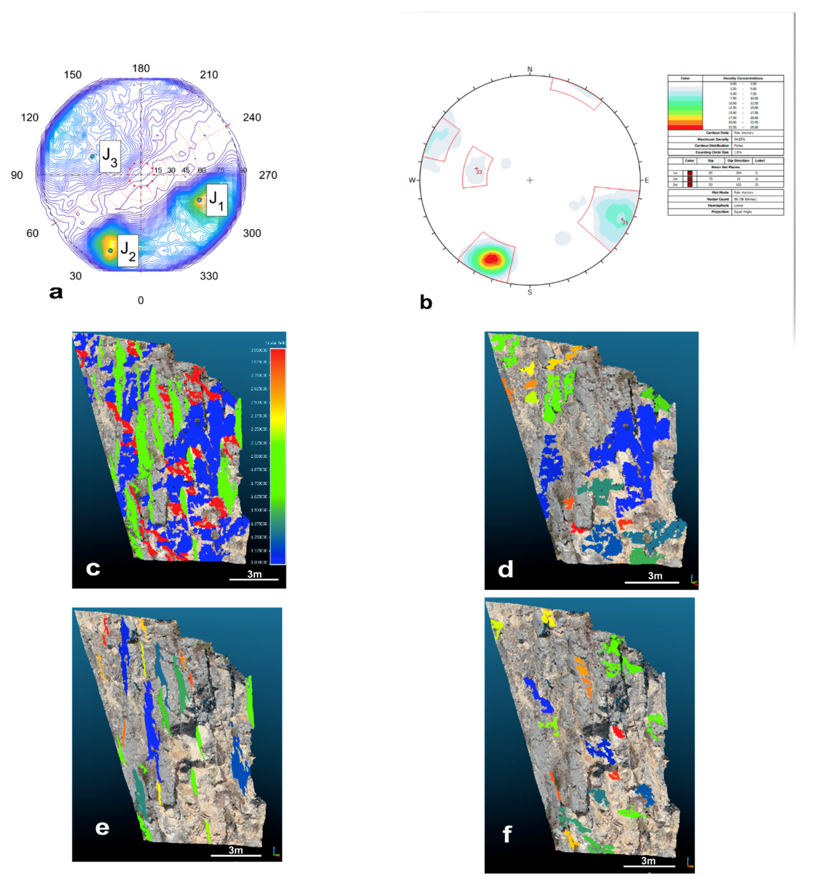

| RMR Classification | |||
|---|---|---|---|
| Parameters | |||
| R1 | 12 | 12 | 12 |
| R2 | 17 | 17 | 17 |
| R3 | 10 | 8 | 10 |
| R4 | 28 | 28 | 28 |
| R5 | 15 | 15 | 15 |
| total | 82 | 80 | 82 |
| Set | DSE | CloudCompare™ Compass Plugin | Field Survey Measurements | ||
|---|---|---|---|---|---|
| Dip/Dip Direction | Density | % | Dip/Dip Direction | Dip/Dip Direction | |
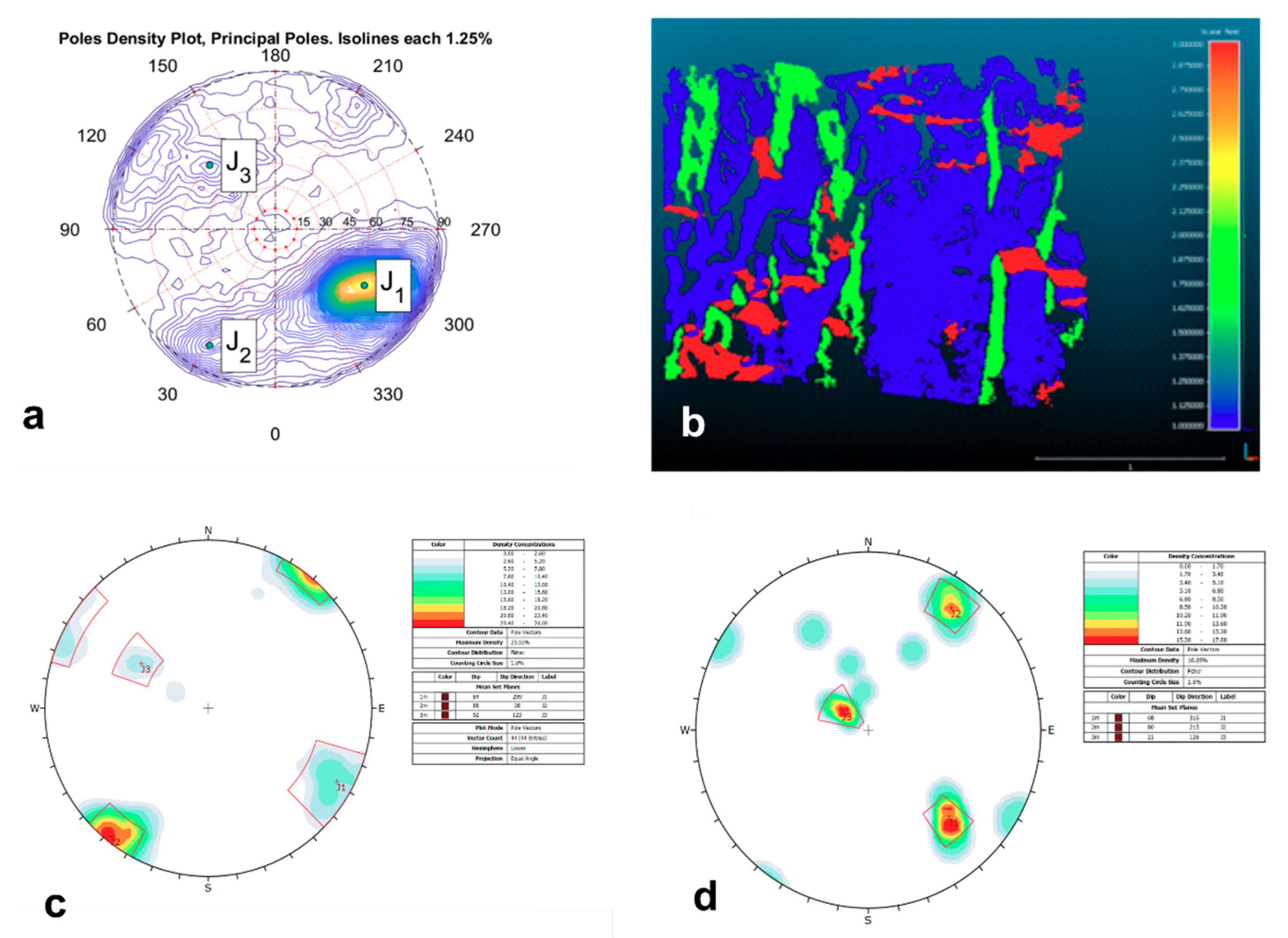
| 66/303 | 3.7 | 69 | 84/299 | 68/316 | |
| 80/028 | 0.7 | 18 | 88/038 | 80/215 | |
| 59/135 | 0.5 | 13 | 52/123 | 21/126 | |
| Set | DSE | CloudCompare™ Compass Plugin | ||
|---|---|---|---|---|
| Dip/Dip Direction | Density | % | Dip/Dip Direction | |
| 66/294 | 1.39 | 43 | 85/294 | |
| 80/021 | 1.65 | 36 | 79/025 | |
| 56/111 | 0.49 | 21 | 53/103 | |
| Plane/Wedge | Dip Direction | Dip | RMRbasic | Type of Failure | SMR 1 | Class 1 | SMR 2 | Class 2 |
|---|---|---|---|---|---|---|---|---|
| 294 | 66 | 83 | toppling | 94 | I | 92 | I | |
| 021 | 80 | 81 | toppling | 92 | I | 89 | I | |
| 111 | 56 | 81 | Wedge/planar | 87 | I | 84 | I | |
| W12 | 313 | 65 | 81 | toppling | 86 | I | 86 | I |
| W13 | 022 | 3 | 81 | toppling | 96 | I | 95 | I |
| W23 | 096 | 55 | 81 | Wedge/planar | 87 | I | 86 | I |
| Plane/Wedge | Dip Direction | Dip | RMRbasic | Type of Failure | SMR 1 | Class 1 | SMR 2 | Class 2 |
|---|---|---|---|---|---|---|---|---|
| 294 | 66 | 83 | toppling | 79 | II | 77 | II | |
| 021 | 80 | 81 | toppling | 71 | II | 67 | II | |
| 111 | 56 | 81 | Wedge/planar | 72 | II | 71 | II | |
| W12 | 313 | 65 | 81 | toppling | 77 | II | 75 | II |
| W13 | 022 | 3 | 81 | toppling | 81 | I | 80 | I |
| W23 | 096 | 55 | 81 | Wedge/planar | 72 | II | 72 | II |
© 2020 by the authors. Licensee MDPI, Basel, Switzerland. This article is an open access article distributed under the terms and conditions of the Creative Commons Attribution (CC BY) license (http://creativecommons.org/licenses/by/4.0/).
Share and Cite
Papathanassiou, G.; Riquelme, A.; Tzevelekis, T.; Evaggelou, E. Rock Mass Characterization of Karstified Marbles and Evaluation of Rockfall Potential Based on Traditional and SfM-Based Methods; Case Study of Nestos, Greece. Geosciences 2020, 10, 389. https://doi.org/10.3390/geosciences10100389
Papathanassiou G, Riquelme A, Tzevelekis T, Evaggelou E. Rock Mass Characterization of Karstified Marbles and Evaluation of Rockfall Potential Based on Traditional and SfM-Based Methods; Case Study of Nestos, Greece. Geosciences. 2020; 10(10):389. https://doi.org/10.3390/geosciences10100389
Chicago/Turabian StylePapathanassiou, George, Adrián Riquelme, Theofilos Tzevelekis, and Evaggelos Evaggelou. 2020. "Rock Mass Characterization of Karstified Marbles and Evaluation of Rockfall Potential Based on Traditional and SfM-Based Methods; Case Study of Nestos, Greece" Geosciences 10, no. 10: 389. https://doi.org/10.3390/geosciences10100389
APA StylePapathanassiou, G., Riquelme, A., Tzevelekis, T., & Evaggelou, E. (2020). Rock Mass Characterization of Karstified Marbles and Evaluation of Rockfall Potential Based on Traditional and SfM-Based Methods; Case Study of Nestos, Greece. Geosciences, 10(10), 389. https://doi.org/10.3390/geosciences10100389


