Article

Habitat Characteristics Coincidence of Dead and Living Long-Tailed Gorals (Naemorhedus caudatus) According to Extreme Snowfall

1
Restoration Research Team (Mammals), Research Center for Endangered Species, National Institute of Ecology, Yeongyang 36531, Korea
2
Department of Animal Science and Biotechnology, Kyungpook National University, Sangju 37224, Korea
3
Department of Horse, Companion, and Wild Animal Science, Kyungpook National University, Sangju 37224, Korea
*
Author to whom correspondence should be addressed.
Animals 2021, 11(4), 997; https://doi.org/10.3390/ani11040997
Submission received: 1 March 2021 / Revised: 29 March 2021 / Accepted: 31 March 2021 / Published: 2 April 2021
(This article belongs to the Section Ecology and Conservation)

Abstract

:

Simple Summary

The long-tailed goral (Naemorhedus caudatus Milne-Edwards) is a critically endangered herbivore in South Korea. From March to June in 2010, 24 animals were found to have died due to heavy snowfall in the Wangpi Stream basin. In this study, we hypothesized that gorals that died due to snowfall are low-status individuals that lived in the sub-optimal or non-suitable areas. The results suggested that the sites where dead gorals were found were highly related to typical goral habitats. The optimal goral habitats could become uninhabitable following heavy snowfall. Most of the dead animals were pregnant females or were young, implying that they could not escape their primary habitats due to lower mobility. Thus, when there is a climate catastrophe, the optimal goral habitats should be considered for rescue and artificial feeding.

Abstract

The long-tailed goral (Naemorhedus caudatus) is a critically endangered herbivore in South Korea. Despite government efforts to recover the population through reintroduction programs, the animal remains vulnerable to heavy snowfall. From March to June 2010, 24 animals were found dead due to heavy snowfall in the Wangpi Stream basin. In this study, we hypothesized that gorals that died due to snowfall are low-status individuals that lived in the sub-optimal or non-suitable areas. Using the occurrence data from extensive field surveys from 2008 to 2010 in the Wangpi Stream and the carcass location data, we (1) defined the goral habitat characteristics and (2) compared the habitat characteristics between dead and living gorals using ensemble species distribution modeling. The results suggested that the sites where dead gorals were found were highly related to typical goral habitats. These results implied that the optimal goral habitats could become uninhabitable following heavy snowfall. Most of the dead animals were pregnant females or were young, implying that they could not escape their primary habitats due to lower mobility. Thus, when there is a climate catastrophe, the optimal goral habitats should be considered for rescue and artificial feeding.

1. Introduction

Extreme winter seasons can affect the foraging behaviors of herbivores and can result in increased fatality [1]. Food deprivation causes a deficiency in energy in herbivores [2]. Moreover, low temperatures during winter lead to high-energy requirements [3]. Besides this, warm spells in the winter with rainfall (rain-on-snow) can occasionally cause “icing,” which restricts access to food, resulting in starvation and lower survival and fecundity rates [4].
Long-tailed goral (Naemorhedus caudatus) belongs to four Naemorhedus species of Caprinae, which are endangered and are one of the least studied montane bovid in the world. The animal is distributed in Eastern and Northern Asian mountains, including Russia, China, and Korea [5,6]. This species is listed as a vulnerable species by the International Union for Conservation of Nature and Natural Resources (IUCN) [7]. Whereas, in South Korea, the species has been protected as a critically endangered species by the Ministry of Environment and natural monument no. 217 by the Cultural Heritage Administration. As of 2018, the estimated population was only 679 individuals in representative habitats [8]. This small population has survived as they inhabit deep valleys and cliffs where humans and predators cannot easily approach them [9].
The species has been protected under the reintroduction policy of the Korean government. However, they still face several threats, such as road-kills and climate change [10,11]. In particular, heavy snowfall represents a mortality risk [12]. Gorals evolved to have shorter forelegs than hind-legs in order to quickly climb cliffs; however, this means that, when they are trapped by heavy snow, they cannot escape and are likely to die from starvation [13].
Two notable incidents occurred due to abnormal heavy snowfalls in South Korea. The first was, from March 1964 to February 1965, approximately 6000 gorals were trapped by snow and died. The second was, from March to June 2010, 24 gorals were found dead in Uljin, a small countryside county [12,14]. In 2010, the fresh snow cover depth was the second highest for 10 years, and the volumes of sunshine and air temperature for six months (from January to June) were remarkably lower than those between 1971 and 2000 (Figure 1). In recent years, strict policies reduced their fatality from human activities, resulting in severe climatic conditions being the most crucial factor decreasing the goral population currently. Thus, it is vital to understand why the gorals die due to abnormal climatic conditions to reduce the fatality of future catastrophes.
Gorals live in flexible, hierarchical social groups [13,15]. They follow a polygyny mating system and live in groups that can comprise over 11 animals, depending on resource availability; however, the males usually live in solitude, except during the rutting season [16,17]. Gorals prefer to live on exposed rocks or on the south-facing regions of steep valleys where snow melts easier and can access their preferred food. However, gorals that are lower in the social hierarchy or yearlings could be expelled to live in areas more vulnerable to heavy snowfall [18]. Besides, in areas with soil with a weak draining capacity, snow does not melt quickly, which can be fatal for gorals. Thus, we hypothesized that the characteristics of both the preferred habitats of gorals and the locations where dead gorals were found would be different. In this study, we aimed to (i) identify the habitat characteristics of gorals, (ii) compare habitat characteristics, and (iii) predict the vulnerable areas.

2. Materials and Methods

2.1. Study Area

Extensive field surveys were conducted in the Wangpi River basin in the eastern part of South Korea (Figure 2a). The selected area was the remote not-industrialized countryside (urban area percentage: 1.00%) [17], which had a high forest cover (over 92.17%) and many streams. A small portion of the land is used for agriculture (approximately 4.96%). In 2018, the Korean red pine (Pinus densiflora Siebold and Zucc.; Pinaceae) was the dominant flora (approximately 46%), while Oak (Fagaceae spp.) occupied 37.66%. Over 90% of trees in the area are aged between 30 and 60 years (Korean National Spatial Data Infrastructure Portal, http://www.nsdi.go.kr (accessed on 1 April 2021).
The area has one of the highest goral populations in South Korea [14], and gorals in the area have distinct genotypes from other populations, probably due to the natural climatic and geographic barriers, such as a high mountainous plateau [19]. However, the study area does contain areas with different population densities. The northern areas (red polygon in Figure 2b of the Gwangcheon Stream watershed have higher population densities than the southern areas (violet polygon of Figure 1b, evidenced by the density of the traces such as feces, marking, etc. [20].

2.2. Field Survey and Carcass Survey

Surveys were conducted based on the line transect method. The survey sites were determined based on remoteness from urban areas and the proportion of the rocky regions by reviewing the literature on goral habitats. Most of the sites were steep rocky valleys with a small human population [13]. The surveys were conducted five times (March, April, May, June, and September) in 2008, three times in 2009, and twice in 2010.
To elucidate the habitat of the gorals, we searched for hairs of the gorals indicating their preferred habitats. When gorals spend more time in a given area or mark their territory by using their horns, they are likely to release hairs at the sites or have hair caught in branches [9]. We used hair and feces to determine the preferred habitats of the gorals, as footprints can be confused with those of other herbivores such as Siberian roe deer (Capreolus pygargus Pallas) and feral goats (Capra hircus Linnaeus) [9,20]. The location of all hair samples was recorded using a GPS recorder (Garmin, 60csx). The forest rangers and residents found the carcasses of dead gorals, and they were only found in the northern parts of the study area [21].

2.3. Environmental Factors Influencing the Habitats of Goral

Based on previous studies, we tentatively selected 27 environmental factors to characterize the habitat conditions of the dead and living gorals (Table 1). Previous studies only considered a few landscape factors, such as altitude, slope, aspect, and anthropogenic factors, such as distance to the road and trail. However, in this study, we considered more factors, such as distance to agricultural fields, factories, human residences, and soil characteristics to explore the primary goral habitats (Table 1) [14,22,23,24]. We considered the density of the anthropogenic, landscape, and forest variables within the male home range (1.46 km2; radius: 682 m measured by GPS collars) [25]. We primarily considered the male home range because typically, the male home range is larger than that of the female due to their solitariness, as such, their range would often encompass the female home range. As soil characteristics might affect the mortality or habitat of the gorals due to the differing snow melting ability related to the thermal cover or vegetation distribution, we added these characteristics as important variables [26]. The study sites are relatively small fragmented habitats, and we did not consider the meteorological factors to differentiate the habitats. The resolution of all variables was resampled to 30 x 30 m using the resample function of the raster R package [27].

2.4. Definition of Habitat Characteristics of Gorals

We built different species distribution models (SDMs) to define the habitat suitability and relationship between goral occurrence and environmental factors [30,31]. We used goral presence data from the line transect method so that the data could be spatially autocorrelated. Thus, before building the models, we cleaned some occurrence points within the home range of goral using the spThin package [32]. We adapted eight model algorithms [33]: two envelopes and distance-based approaches (BIOCLIM and Domain [34]), two regression-based approaches (generalized linear models (GLMs [34]) and generalized additive models (GAMs [35]), and four machine-learning methods (classification and regression trees (CART [36]), random forests (RFs [37]), boosted regression trees (BRTs [38]), and Maxent [39]). The Fine-tuning of each model was conducted according to the instructions from the practices by Dr. Zurell (https://www.damariszurell.io/HU-GCIB/5_SDM_algorithms.html) (accessed on 1 April 2021).
Before building the model, we evaluated the collinearity and removed the collinear variables by assessing the variance inflation factors (cut-off value = 5) with the vifstep function of the “usdm” packages in R Studio v1.1.456 [40]. Then, we excluded eight variables, especially the distance to a rice paddy, soil drainage, tree age class, degree of rock exposure, distance to a factory, stream density, aspect, and tree diameter class. We explored the relationships between the goral presence and each environmental variable in order to identify the relevant variables. First, we validated the predictive power by adding the variables using 10-fold cross-validation procedures to estimate the area under the ROC curve (AUC ≥ 0.80) and True Skill Statistic (TSS) (≥0.6). The procedure was repeated 50 times, and the results were averaged [41,42]. If the added variables did not improve the model accuracy (i.e., average variable importance ≤ 5), we extracted them and added other ones. Second, if the plotted models did not show reasonable relationships, we did not consider those variables [43]. For example, when the relationship between the presence of gorals and the distance to streams exhibited quadratic shapes, which could not be explained, we considered the corresponding variable as a non-influential factor. Finally, after determining all the influential variables, we conducted 10-fold cross-validation and selected the model algorithms that showed a high goodness of fit (ROC curve ≥ 0.80 and TSS ≥ 0.60). We then used the median of the model performance [30]. We used the varImp function of the caret R package [44] to define the variable importance. For the algorithms for which the R packages do not provide importance (BIOCLIM, Domain, and Maxent from maxnet R package), we calculated the importance based on the ROC curve (importance = 1 − AUC) by excluding each included variable from the full combination of variables [44,45]. Then, the relative importance was calculated by dividing the variable importance by the total importance.

2.5. Definition of Site Characteristics of Dead Gorals

When we determined the goral presence sites, we clipped the areas in the upper study regions (red polygon in Figure 2b due to considerably different goral densities [20]. Then, we made 50 background points in the polygon to differentiate the habitat characteristics of dead gorals using the randomPoints function of the dismo R package [27]. By following the previous procedures (identification of relevant variables) of variable selection using ensemble SDMs, we defined the habitat characteristics of dead gorals (Figure 3).

3. Results

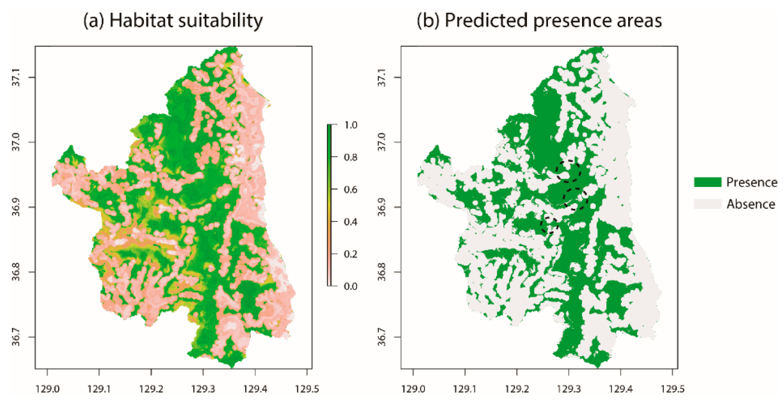
3.1. Habitat Characteristics of Gorals in Uljin

The models that reached fair levels of goodness-of-fit were RFs (AUC = 1.00 ± 0.00 and TSS = 1.00 ± 0.00; Average ± Standard error) and BRTs (AUC = 0.81 ± 0.002 and TSS = 0.64 ± 0.003; Figure S1). The ensemble model had high levels of goodness-of-fit (AUC = 0.87 and TSS = 0.69) and suggested that the distance to the field (m), coniferous tree density (m2), and distance to the trail (m) influenced the goral habitats (Figure 4). Distance to the field (m, 0.59 ± 0.09) was identified as the most influential factor (Figure 4a). The probability of the goral increased in regions with a high density of coniferous trees and increased as the distance to fields and trails increased (Figure 4b).
It was observed that there were large clusters located in the central longitudinal areas (Figure 5), whereas there were a few optimal areas in the western regions. However, the suitability was distinctively lower in eastern areas near the seashore (Figure 5a). When thresholds were divided into presence and absence areas, the clusters in longitudinal centers were fragmented and were weakly connected in some areas (dotted circles in Figure 4b). The western regions were remarkably fragmented (Figure 5b).

3.2. Site Characteristics of Dead Gorals

The models that had fair levels of goodness-of-fit were RFs (AUC = 1.00 ± 0.00 and TSS = 1.00 ± 0.00), Maxent (AUC = 0.81 ± 0.003 and TSS = 0.65 ± 0.01), and Domain (AUC = 0.80 ± 0.002 and TSS = 0.64 ± 0.004; Figure S2). The ensemble model scored high levels of goodness-of-fit (AUC = 0.88 and TSS = 0.65) and suggested that the influential factors were similar to those of the preferred habitats of the goral, such as distance to the field (m) and coniferous tree density (m2). However, aspect (°) was newly selected (Figure 6). The distance to the field (0.41 ±   0.03%) was identified as the most influential factor. Other factors were also severely influential (Figure 6a). The probability of goral mortality due to snowfall generally increased with an increase in distance to fields and areas with higher coniferous tree densities, as found in south-east facing areas (Figure 6b).
A large cluster of areas with a high goral mortality rate is located in the central longitudinal regions (Figure 7a). Within the cluster, some areas were fragmented because the map excluded the south-east facing areas (Figure 7b).

4. Discussion

The long-tailed goral is a critically endangered species and is one of the least studied species of montane ungulates [6,7]. As defining the distribution and habitat characteristics was conducted prior the study to make conservation plans for the endangered species, investigating the ecology of the habitat of gorals is urgently needed [46]. Several studies explored the habitat characteristics of gorals. Most of them focused on landscape factors, such as slope, altitude, aspect, and distance to streams [14,22,23,25]. However, as gorals can be flexible regarding these factors, the results of these studies cannot be used to generalize ideal habitat characteristics. For example, individual herbivores of the same species, including gorals, can adapt to different altitudes based on food abundance and human disturbances [47]. Therefore, the results of previous studies on goral habitats did not have a complete view [13,14]. The results of our habitat analysis suggest that human disturbance was the primary factor influencing the goral habitat.
By exploring the relevant variables of the 27 tentative environmental factors, the habitat characteristics of gorals suggest that the species could be critically susceptible to human activity (Figure 4 and Figure 5) [24]. Large distances from fields and trails and the high density of coniferous trees indicate habitats that are less disturbed by humans and are more remote [13]. Areas with a high density of broadleaf trees provide optimal living conditions for gorals. However, these areas also have a high human population [48]. Thus, in our study, we found that gorals preferred to live in areas with a high density of coniferous trees, even though areas with broadleaf trees offered continuous food availability [49]. It is difficult for gorals to avoid human activity as activities often occur in goral habitats, as the areas of optimal habitat for gorals are shrinking and fragmented in terms of the edge effect. Therefore, it is crucial to review the ongoing construction and land use changes within the habitats of the gorals. In Uljin, as highways were constructed, the government planned for local roads to be restored as non-paved roads. While the restoration could provide more suitable habitats, the construction and restoration impacts should be thoroughly investigated initially. The cable car construction in the Seorak national mountain, which has the highest goral population, should be reconsidered.
Habitat selection by gorals could be dependent on their rank within the hierarchy [50]. Gorals of low-status may suffer from reduced access to resources, whereas those in the higher-order generally have priority access [51]. Within the group, the location of territory and its suitability can also be determined by rank [52]. For example, the optimal habitats to survive heavy snowfall could be occupied by the individual with the highest ranking. Thus, analyzing the spatial positions related to the ranks could suggest some reasons why gorals have been found dead in abnormal climates during the winter season.
The difference between the preferred habitats of gorals and high mortality areas was rejected, which disagrees with our hypothesis. We found that the characteristics of areas with a high mortality rate also represented the preferred habitats of gorals. Variables such as large distances to the field and high density of coniferous trees are the same variables that explain the preferred habitats of gorals. For example, south-east facing areas are the preferred habitats of gorals because snow melts quicker due to more sunlight exposure, as the preferred diet grows more easily on these aspects [15,49]. However, our results suggested that a high mortality rate also characterized these areas. Thus, we concluded that mobility might be the most critical factor affecting the survival of gorals.
Most of the dead gorals (89.4%) were yearlings or pregnant females (Table 2) [21]. The autopsy report from the dead gorals suggested that they were starved but had no diseases. Generally, their mobility is less than that of males and nongravid females [53,54]. In low temperatures, pregnant females spend more energy maintaining their body temperature for their cubs [55], whereas yearlings usually have less physical ability than adults. When heavy snowfall occurs, most gorals tend to migrate to lower altitudes [12,25,56]. However, if gorals are unable to escape from stacked snow, their home ranges become smaller, and they are forced to stay in solitude in their preferred areas, such as rocky south-facing areas [15,25,57]. While these areas offer food, as the weather becomes extreme, the vegetation cover decreases. The lower food availability causes gorals to become exhausted and can potentially starve.
If the “age” and the “dominant rank” of animals are proportional, intraspecific competition (i.e., male > female and adult > juvenile) might also affect mortality. However, our previous research showed that the age and dominant rank of the gorals were not proportional [17]. The number of adults (5 ± 3) was higher than those of juveniles (3 ± 2). Besides, the number of females (4.5 ± 0.5) was higher than males (2.5 ± 0.5). However, even though the sites were the representative habitats for the goral, the number of sites in the study area was only two. While the information was limited, any study reporting that intraspecific competition of gorals can cause high mortality for females and juveniles is unknown to us.
The survival of pregnant females and yearlings is crucial to increase the goral population [10]. The remote countryside offers gorals an optimal habitat (Figure 4). However, when extreme snowfall occurs, these areas become the regions with the highest mortality rates (Figure 5). As most gorals migrate to lower altitudes due to heavy snowfalls, it was believed that the priority rescue areas should be at lower altitudes. However, our results suggest that high altitude remote areas with high goral population density should be focused on, as rescuing gorals belonging to vital age classes is necessary to increase their population. Thus, the primary sites for rescue and artificial feeding should be considered and established at optimal goral habitats in a climate catastrophe event.

5. Conclusions

Extreme winter seasons can affect the foraging behaviors of herbivores and result in an increased fatality. This study hypothesized that gorals that die due to abnormal weather conditions could be low-status individuals who live in sub-optimal or non-suitable areas. The habitat comparisons between dead and living long-tailed gorals using SDMs suggested that the sites where carcasses were identified were highly related to typical goral habitats, thus contradictory to our hypothesis. The results implied that optimal goral habitats could become deadly following heavy snowfall. The dead animals were mainly pregnant females or young individuals who could not escape their primary habitats due to their low mobility. Thus, we concluded that primary sites for rescue and artificial feeding should be established in the optimal goral habitats when there is a climate catastrophe.

Supplementary Materials

The following are available online at https://www.mdpi.com/article/10.3390/ani11040997/s1, Figure S1: Box plots of the average and standard error of AUC and TSS values of 8 model algorithms (BIOCLIM, Domain, GLMs, GAMs, CART, RFs, BRTs, and Maxent) to predict goral habitats. The dotted circles indicate the selected models of the eight models using the ensemble model. Figure S2: Box plots of the average and standard error of AUC and TSS values of 8 model algorithms (BIOCLIM, Domain, GLMs, GAMs, CART, RFs, BRTs, and Maxent) to predict areas with high mortality rate due to heavy snowfall. Please see my above comment.

Author Contributions

Conceptualization, H.-B.P., and S.H.; methodology, S.H.; software, S.H.; validation, S.H.; formal analysis, S.H.; investigation, H.-B.P.; resources, H.-B.P.; data curation, H.-B.P.; writing—original draft preparation, S.H.; writing—review and editing, S.H.; visualization, S.H.; supervision, S.H.; project administration, H.-B.P.; funding acquisition, H.-B.P., and S.H. All authors have read and agreed to the published version of the manuscript.

Funding

This research was funded by National Research Foundation of Korea, grant number 2021R1C1C2004162 and was supported by the National Institute of Ecology (NIE-C-2021-46).

Institutional Review Board Statement

The study was conducted in accordance with the guidelines of the Institutional Review Board of the Kyungpook National University.

Data Availability Statement

Data available on request due to restrictions.

Conflicts of Interest

The authors declare no conflict of interest.

References

  1. Schaefer, J.A.; Messier, F. Habitat selection as a hierarchy: The spatial scales of winter foraging by muskoxen. Ecography 1995, 18, 333–344. [Google Scholar] [CrossRef]
  2. Tews, J.; Ferguson, M.A.D.; Fahrig, L. Modelling density dependence and climatic disturbances in caribou: A case study from the Bathurst Island complex, Canadian High Arctic. J. Zool. 2007, 272, 209–217. [Google Scholar] [CrossRef] [Green Version]
  3. Hong, S.; Cowan, P.; Do, Y.; Gim, J.S.; Joo, G.J. Seasonal feeding habits of coypu (Myocastor coypus) in South Korea. Hystrix 2016, 27, 123–128. [Google Scholar]
  4. Albon, S.D.; Irvine, R.J.; Halvorsen, O.; Langvatn, R.; Loe, L.E.; Ropstad, E.; Veiberg, V.; van der Wal, R.; Bjorkvoll, E.M.; Duff, E.I.; et al. Contrasting effects of summer and winter warming on body mass explain population dynamics in a food-limited Arctic herbivore. Glob. Chang. Biol. 2017, 23, 1374–1389. [Google Scholar] [CrossRef]
  5. Grubb, P. Order Artiodactyla. In Mammal Species of the World, 3rd ed.; Wilson, D.E., Reeder, D.M., Eds.; The Johns Hopkins University Press: Baltimore, MD, USA, 2005; pp. 637–722. [Google Scholar]
  6. Zaumyslova, O.Y.; Bondarchuk, S.N. The use of camera traps for monitoring the population of long-tailed gorals. Achiev. Life Sci. 2015, 9, 15–21. [Google Scholar] [CrossRef]
  7. Bragina, E.; Kim, S.; Zaumyslova, O.; Park, Y.S.; Lee, W. Naemorhedus caudatus. IUCN Red List Threat. Species 2020, 2020, e.T14295A22150540. Available online: https://iucnredlist.org/species/14295/22150540 (accessed on 1 April 2021).
  8. SRTI. Annual Report; Species Restoration Technology Institute (SRTI): Gurye, Korea, 2018. [Google Scholar]
  9. Park, H.B.; Park, H.C.; Cowan, P.E.; Hong, S. Comparison of hair-trapping methods for the long-tailed goral. Wildl. Soc. Bull. 2018, 42, 310–313. [Google Scholar] [CrossRef]
  10. Kim, B.J.; Lee, B.K.; Lee, H.; Jang, G.S. Considering threats to population viability of the endangered Korean long-tailed goral (Naemorhedus caudatus) using VORTEX. Anim. Cells Syst. 2016, 20, 52–59. [Google Scholar] [CrossRef] [Green Version]
  11. Lee, S.; Kim, B.J.; Bhang, K.J. Habitat analysis of endangered Korean long-tailed goral (Naemorhedus caudatus raddeanus) with weather forecasting model. Sustainability 2019, 11, 6086. [Google Scholar] [CrossRef] [Green Version]
  12. Won, B.H. Illustrated Encyclopedia of Fauna and Flora of Korean Mammals; Samhwa: Seoul, Korea, 1967. [Google Scholar]
  13. Yang, B.G. Systematics, Ecology and Current Population Status of the Goral, Naemorhedus caudatus, in Korea. Ph.D. Thesis, Chungbuk National University, Cheongju, Korea, 2002. [Google Scholar]
  14. Park, H.B. The Habitat Using Characteristics of Long-Tailed Goral (Naemorhedus caudatus) in the Northern Region of Gyeongbuk Province and the Effect of Climate Change. Master’s Thesis, Kyungpook National University, Dae-gu, Korea, 2011. [Google Scholar]
  15. Myslenkov, A.I.; Voloshina, I.V. Ecology and Behaviours of the Amur Goral; Nauka: Moscow, Russia, 1989. [Google Scholar]
  16. Chaiyarat, R.; Laohajinada, W.; Kutintara, U.; Nabhitabhata, J. Ecology of the Goral in Om Koi Wildlife Sanctuary, Thailand. Nat. Hist. Bull. Siam Soc. 1999, 47, 191–205. [Google Scholar]
  17. Park, H.B.; Han, C.W.; Hong, S. Camera trapping of long-tailed goral (Naemorhedus caudatus) in BaekAm and Geumjong Mountains, South Korea. J. For. Environ. Sci. 2018, 34, 71–76. [Google Scholar]
  18. Mishra, C.; Johnsingh, A.J.T. On habitat selection by the goral Nemorhaedus goral bedfordi (Bovidae, Artiodactyla). J. Zool. 1996, 240, 573–580. [Google Scholar] [CrossRef]
  19. Choi, S.K.; Chun, S.; An, J.; Lee, M.Y.; Kim, H.J.; Min, M.S.; Kwon, S.W.; Choi, T.Y.; Lee, H.; Kim, K.S. Genetic diversity and population structure of the long-tailed goral, Naemorhedus caudatus, in South Korea. Genes Genet. Syst. 2015, 90, 31–41. [Google Scholar] [CrossRef] [PubMed] [Green Version]
  20. CHA. Survey and Monitoring Long-Tailed Goral (Naemorhedus caudatus) in Uljin, Samcheok, Bonghwa Areas; Cultural Heritage Administration: Daejeon, Korea, 2007. [Google Scholar]
  21. CGRB. Autopsy Report of the Dead Long-Tailed Goral (Naemorhedus caudatus) in Uljin; Conservation Genome Resource Bank for Korean Wildlife: Seoul, Korea, 2010. [Google Scholar]
  22. Choi, T.Y.; Park, C.H. Korean goral potential habitat suitability model at Soraksan National Park using fuzzy set and multi-criteria evaluation. J. Korean Inst. Landsc. Archit. 2004, 32, 28–38. [Google Scholar]
  23. Seo, C.W.; Choi, T.Y.; Choi, Y.S.; Kim, D.Y. A study on wildlife habitat suitability modelling for goral (Nemorhaedus caudatus rddeanus) in Seoraksan National Park. J. Korea Soc. Environ. Restor. Technol. 2008, 11, 28–38. [Google Scholar]
  24. Kim, D.B.; Koo, K.A.; Kim, H.H.; Hwang, G.Y.; Kong, W.S. Reconstruction of the habitat range suitable for long-tailed goral (Naemorhedus caudatus) using fossils from the Paleolithic sites. Quat. Int. 2019, 519, 101–112. [Google Scholar] [CrossRef]
  25. Cho, C.; Kim, K.; Kwon, G. Habitat altitude and home range of the endangered long-tailed goral (Naemorhedus caudatus): Seasonal and monthly home range and altitude change. Mammalia 2015, 80, 481–489. [Google Scholar] [CrossRef]
  26. Cook, J.G.; Irwin, L.L.; Bryant, L.D.; Riggs, R.A.; Thomas, J.W. Relations of forest cover and condition of elk: A test of the thermal cover hypothesis in summer and winter. Wildl. Monogr. 1998, 141, 3–61. [Google Scholar]
  27. Hijmans, R.J. Package “Raster”: Geographic Data Analysis and Modeling. The Comprehensive R Archive Network, CRAN. 2014. Available online: https://CRAN.R-project.org/package=raster (accessed on 1 April 2021).
  28. Won, C.M.; Smith, K.G. History and current status of mammals of the Korean peninsula. Mamm Rev. 1999, 29, 3–36. [Google Scholar] [CrossRef]
  29. Chen, W.; Hu, J.C.; Lu, X. Habitat use and separation between the Chinese serow (Capricornis milneedwardsi) and the Chinese goral (Naemorhedus griseus) in winter. Mammalia 2009, 73, 249–252. [Google Scholar] [CrossRef]
  30. Araujo, M.B.; New, M. Ensemble forecasting of species distributions. Trends Ecol. Evol. 2007, 22, 42–47. [Google Scholar] [CrossRef] [PubMed]
  31. Hong, S.; Kim, J.Y.; Kim, Y.M.; Kim, D.K.; Joo, G.J. Factors influencing initial population establishment and habitat expansion of introduced nutrias (Myocastor coypus) in South Korea. Ecol. Inform. 2020, 59, 101111. [Google Scholar] [CrossRef]
  32. Aiello-Lammens, M.E.; Boria, R.A.; Radosavljevic, A.; Vilela, B.; Anderson, R.P. spThin: An R package for spatial thinning of species occurrence records for use in ecological niche models. Ecography 2015, 38, 541–545. [Google Scholar] [CrossRef]
  33. Guisan, A.; Thuiller, W.; Zimmermann, N.E. Habitat Suitability and Distribution Models: With Applications in R; Cambridge University Press: Cambridge, UK, 2017. [Google Scholar]
  34. Hijmans, R.J.; Phillips, S.; Leathwick, J.; Elith, J. Dismo: Species Distribution Modeling; R Package Version 1.1-4; 2017; Available online: https://cran.r-project.org/web/packages/dismo/index.html (accessed on 1 April 2021).
  35. Hastie, T. Gam: Generalized Additive Models; R Package Version 1.20; 2020; Available online: https://CRAN.R-project.org/package=gam (accessed on 1 April 2021).
  36. Therneau, T.; Atkinson, B. Rpart: Recursive Partitioning and Regression Tress; R Package Version 4.1-15; 2019; Available online: https://CRAN.R-project.org/package=rpart (accessed on 1 April 2021).
  37. Liaw, A.; Wiener, M. Classification and Regression by randomForest. R News 2002, 2, 18–22. [Google Scholar]
  38. Greenwell, B.; Boehmke, B.; Cunningham, J.; Developers, G.B.M. GBM: Generalized Boosted Regression Models; R Package Version 2.1.8; 2020; Available online: https://CRAN.R-project.org/package=gbm (accessed on 1 April 2021).
  39. Philips, S. Maxnet: Fitting ‘Maxent’ Species Distribution Models with ‘Glmnet’; R Package Version 0.1.2; 2017; Available online: https://CRAN.R-project.org/package=maxnet (accessed on 1 April 2021).
  40. Naimi, B.; Hamm, N.A.S.; Groen, T.A.; Skidmore, A.K.; Toxopeus, A.G. Where is positional uncertainty a problem for species distribution modelling? Ecography 2014, 37, 191–203. [Google Scholar] [CrossRef]
  41. Pearce, J.; Ferrier, S. Evaluating the predictive performance of habitat models developed using logistic regression. Ecol. Model. 2000, 133, 225–245. [Google Scholar] [CrossRef] [Green Version]
  42. Allouche, O.; Tsoar, A.; Kadmon, R. Assessing the accuracy of species distribution models: Prevalence, kappa and the true skill statistic (TSS). J. Appl. Ecol. 2006, 43, 1223–1232. [Google Scholar] [CrossRef]
  43. MacNally, R. Regression and model-building in conservation biology, biogeography and ecology: The distinction between—And reconciliation of—‘predictive’ and explanatory’ models. Biodivers. Conserv. 2000, 9, 655–671. [Google Scholar] [CrossRef]
  44. Kuhn, M. Caret: Classification and Regression Training; R Package Version 6.0-86; 2020; Available online: https://CRAN.R-project.org/package=caret (accessed on 1 April 2021).
  45. Biecek, P. DALEX: Explainers for complex predictive models in R. J. Mach. Learn. Res. 2018, 19, 1–5. [Google Scholar]
  46. Krebs, C. Ecology: The Experimental Analysis of Distribution and Abundance, 6th ed.; Pearson: San Francisco, CA, USA, 2009. [Google Scholar]
  47. Pepin, D.; Adrados, C.; Janeau, G.; Joachim, J.; Mann, C. Individual variation in migratory and exploratory movements and habitat use by adult red deer (Cervus elaphus L.) in a mountainous temperate forest. Ecol. Res. 2008, 23, 1005–1013. [Google Scholar] [CrossRef]
  48. Bhattacharya, T.; Bashir, T.; Poudyal, K.; Sathyakumar, S.; Saha, G.K. Distribution, occupancy and activity patterns of goral (Nemorhaedus goral) and Serow (Capricornis thar) in Khangchendzonga Biosphere Reserve, Sikkim, India. Mamm. Study 2012, 37, 173–181. [Google Scholar] [CrossRef]
  49. Ilyas, O.; Khan, J.A. Food habits of barking deer (Muntiacus muntjak) and goral (Naemorhedus goral) in Binsar Wildlife Sanctuary, India. Mammalia 2003, 67, 521–532. [Google Scholar] [CrossRef]
  50. Ekman, J.B.; Askenmo, C.E.H. Social rank and habitat use in willow tit groups. Anim. Behav. 1984, 32, 508–514. [Google Scholar] [CrossRef]
  51. Barroso, F.G.; Alados, C.L.; Boza, J. Social hierarchy in the domestic goat: Effect on food habits and production. Appl. Anim. Behav. Sci. 2000, 69, 35–53. [Google Scholar] [CrossRef]
  52. Krause, J. Differential fitness returns in relation to spatial position in groups. Biol. Rev. 1994, 69, 187–206. [Google Scholar] [CrossRef] [PubMed]
  53. Fritzell, E.K. Habitat use by prairie raccoons during the waterfowl breeding season. J. Wildl. Manag. 1978, 42, 118–127. [Google Scholar] [CrossRef]
  54. Malagnino, A.; Marchand, P.; Garel, M.; Cargnelutti, B.; Itty, C.; Chaval, Y.; Hewison, A.J.M.; Loison, A.; Morellet, N. Do reproductive constraints or experience drive age-dependent space use in two large herbivores? Anim. Behav. 2021, 172, 121–133. [Google Scholar] [CrossRef]
  55. Schmidt, N.M.; Grondahl, C.; Evans, A.L.; Desforges, J.; Blake, J.; Hanse, L.H.; Beumer, L.T.; Mosbacher, J.B.; Stelvig, M.; Greunz, E.M.; et al. On the interplay between hypothermia and reproduction in a high arctic ungulate. Sci. Rep. 2020, 10, 1514. [Google Scholar] [CrossRef]
  56. Mitra, S. Gorals (Nemorhaedus goral hodgsoni) in Mahananda wildlife sanctuary, West Bengal, India. Zoos Print J. 2003, 18, 1199–1201. [Google Scholar] [CrossRef]
  57. Pendharkar, A.P.; Goyal, S.P. Group size and composition of the gray goral in Simbalbara Sanctuary and Darpur reserved forest, India. J. Mammal. 1995, 76, 906–911. [Google Scholar] [CrossRef]
Figure 1. Climatic conditions in 2010 compared to those in other years. (a) Monthly average fresh snow cover depth (cm) for three months (January: dark bar, February: intermediate dark bar, and March: light bar) from 2001 to 2010, (b) monthly average sunshine (hr) and (c) air temperature for six months (from January to June) of 2010 (dotted line), compared to that between 1971 and 2000 (line) and the monthly number of dead gorals.
Animals 11 00997 g001
Figure 2. (a) Land use in South Korea and (b) study sites (red: urban, yellow: agriculture, dark green: forest, light green: grassland, violet: wetland, emerald: bare land, and blue: water). The emerald polygon represents the protected area. Light and dark red points represent the locations of goral carcasses and hair samples, respectively.
Animals 11 00997 g002
Figure 3. (a) Procedures of ensemble species distribution modeling to predict the potential distribution of gorals (orange polygon) and areas with a high mortality rate (blue polygons). (b) An example of the predicted habitat of the gorals and areas with a high mortality rate.
Animals 11 00997 g003
Figure 4. Three selected variables of ensemble model with the algorithms of Random Forest and Boosted Regression Tree: (a) relative variable importance (%) and (b) relationship between goral presence probabilities and the three relevant factors.
Animals 11 00997 g004
Figure 5. Habitat suitability (a) and predicted presence-absence areas (b) within the study sites. (a) Areas with high suitability are represented in green, whereas low suitability areas are represented in pink. (b) Predicted presence areas are represented in green, whereas absence areas are represented in light gray. The dotted circles indicate areas where the connectivity between fragmented areas is low.
Animals 11 00997 g005
Figure 6. Three selected variables of the ensemble model with the algorithms of Random Forest, Maxent, and Domain. (a) Relative variable importance (%) and (b) relationship between goral presence probabilities and the three relevant factors.
Animals 11 00997 g006
Figure 7. Mortality probability due to heavy snowfall (a) and predicted mortality areas (b) within the study sites. (a) Areas with high mortality are represented in green, whereas low mortality areas are represented in pink; (b) areas of predicted death are represented in green.
Animals 11 00997 g007
Table 1. Description, abbreviation, related references, and source map (website, resolution, and making year) of the 27 selected variables.
NoClassificationFactorsDescription and Hypothesis from LiteratureReferenceSource Map
1Anthropo
genic fac
tors
Distance to factory (m)Human activity can negatively affect the goral habitats.[22,23,24,28]EGIS (https://egis.me.go.kr (accessed on 1 April 2021), 30 × 30 m, 2007)
2Distance to road (m)
3Road density (m2/1.46 km2)
Human population density (n/1.46 km2)
4Distance to rice paddy (m)
5Distance to field (m)
6Field density (m2/1.46 km2)
7Distance to trail (m)
8ForestDistance to deciduous forest (m)Types of forest can influence goral’s feeding and marking sites.[13,15,23]National Spatial Data Infrastructure Portal (http://nsdi.go.kr (accessed on 1 April 2021), 5 × 5 m, 2018)
9Density of deciduous forest (m2/1.46 km2)
10Density of coniferous forest (m2/1.46 km2)
11Density of forest
(m2/1.46 km2)
12Age class
(1 (young) to 9 (old))
13Diameter class
(0 (young) to 3 (large))
14Crown density
(1 (sparse) to 3 (dense))
15LandscapeDistance to stream (m)Gorals used to live near the waterway.[14,15] EGIS (https://egis.me.go.kr (accessed on 1 April 2021), 10 × 10 m, 2013)
16Stream density
(m2/1.46 km2)
17Lake density
(m2/1.46 km2)
18Altitude (m)Gorals used to live at high altitudes to avoid anthropogenic disturbance.[17,24]Biz-gis (www.biz-gis.com (accessed on 1 April 2021), 30 × 30 m)
19Aspect (1 to 360)As snow can be more easily melt, the gorals prefer the habitats in southern regions. [14,15,29]Biz-gis (www.biz-gis.com (accessed on 1 April 2021), 30 × 30 m)
20Slope (°)Gorals prefer to live in the deep valleys to avoid humans. [22,28]Biz-gis (www.biz-gis.com (accessed on 1 April 2021), 30 × 30 m)
21Soil mapSoil drainage
(1 (bad) to 4 (very good))
If water cannot be displaced, snow becomes stacked. The large quantity of snow can negatively affect the goral’s escape from the snow.[14]National Spatial Data Infrastructure Portal (http://nsdi.go.kr (accessed on 1 April 2021), 25 × 25 m, 2018)
22Degree of rock exposure
(1 (little) to 4 (a lot))
Gorals prefer to live in front of large rocks to escape from predation. Besides, stacked snow melts more quickly than in other soil.[13,15,26]
23Soil type
(1 (no) to 3 (many))
Strongly eroded soil stacked by snowfall could make gorals fall easily.
24Degree of wind exposure
(1 (exposed) to 3 (closed))
Exposure to wind can cause snow to remain for a long period.[4,14]
25Distance to wet soil (m)Moist soil delays the rate of snow melting.[14]
26Wet soil density
(m2/1.46 km2)
27Slant type
(1 (rising slope) to 3 (falling slope))
Gorals prefer to live in convex slopes to escape from predation.[13]
Table 2. Carcass information (observed and collected day, sex, age class (yearling: age < 1, juvenile 1 < age < 3, adult > 3), estimated ages, and pregnancy; CGRB, 2010).
NoObserved DayCollected DaySexAge ClassEstimated AgesPregnant
12010.03.162010.03.19MJuvenile>1
203.2304.01FAdult>15Y
303.2503.26MYearling<1
403.2804.01 Adult5–6
503.3104.02 Juvenile>1
604.0704.07F Adult>10Y
704.0304.08FAdult>10Y
804.0904.09MJuvenile>1
904.0904.09 Yearling<1
1004.1004.10 Juvenile<1
1104.1004.10MJuvenile>1
1204.1104.11FAdult5–8Y
1304.1004.10MJuvenile<1
1404.1104.11FJuvenile>1
1504.1104.11 Juvenile<1
1604.2004.21FAdult
1704.2004.21 Juvenile
1804.2104.29
1904.2104.21 Juvenile
2004.2104.21 Juvenile
Publisher’s Note: MDPI stays neutral with regard to jurisdictional claims in published maps and institutional affiliations.

