1. Introduction
Over several centuries, mining and quarrying reshaped the upland region of Halkyn Mountain, in northeast Wales. By the nineteenth century, it was one of Britain’s major lead mining areas (
Ellis 1998;
Frost and Jones 2004;
Jones et al. 2004;
Williams and Williams 2012), and the extraction of lead ore and ancillary industries such as smelting continued to be major activities during the early part of the twentieth. Fortunes were made by mine owners, syndicates and investors, although extraction had significant environmental, social and economic effects. The last lead mine closed in 1987, but the industry had been in decline since the 1950s, and many mines were shut by the 1970s. Only a few people alive in the area today remember what Halkyn Mountain looked like during these final years of lead mining. Yet, when one walks on and around it, evidence of the industry’s past and its transformative reach is apparent everywhere. This extractive history is essential to understanding Halkyn Mountain’s contemporary character, and the mining legacy is a key element in the construction of community identity and local heritage production. The mountain is a multilayered place of surface, depth and volume, and of human and non-human entanglement. It has been made and transformed by earthly forces, weathering, geomorphological and human action; by subterranean water flow through Carboniferous limestone, and by digging, burrowing and extraction; by internal rupture, the tapping of fissures, tunnelling and the disruption of watercourses; as well as by the upheaval and movement of earth and rock; and by grazing, burning, clearing and churning up the surface. It continues to be shaped and brought into being by landscape management and conservation strategies, by quarrying, by the lifeworlds of plants and animals, and by various perspectives on what constitutes a landscape and what infuses it with meaning.
Gavin Bridge has written about how mines have often been portrayed in art, literature, scholarship and traveller’s accounts as “either disrupting the natural sublime or terminating a pastoral idyll” (
Bridge 2004, p. 243). Old and derelict mining sites are reminders of an intrusive industry that have despoiled what are considered to have once been natural places, and their reclamation becomes a key policy objective for environmental management. This is not always a case of just cleaning up the disorder, messiness and contamination left behind. Habitats can be recreated on ruined, derelict or degraded sites, as
Seitz et al. (
2019) show for bee conservation in reclaimed sand mines in Maryland, in the United States, for example. Disused mining landscapes can become experiments in rewilding, or become forested and hold out hope for conservationists that animals can wander in by themselves, in the way that
Müller et al. (
2017) and
Tsing (
2019) recount of red deer, biodiversity and the emergence of a novel landscape in a former brown coal mine site in Denmark. Landscapes that have been radically altered, reshaped and formed by extraction can become special in new ways. On Halkyn Mountain, as the mines closed, there was no specific land reclamation process that aimed to restore it to resemble what was imagined to be a pre-extractive character (which would be difficult, anyway, given that mining first took place there more than two thousand years ago), although monitoring for contamination has been and continues to be carried out. Shafts have been capped, and buildings and other structures have been dismantled or fallen in decay, but things have grown over; it appears tussocky, wild, and unkempt, but the mountain is worked by graziers and managed according to customary practices of the commons as well as by the regulations that surround sites of special scientific interest and habitat. As in other former mining sites (e.g.,
Johnson et al. 1978;
Rotherham et al. 2012), a habitat for flora and fauna has emerged from the ruination brought by industrial activity on the mountain. Adits, shafts, tunnels, ledges and crevasses in the old mines, quarries and gravel pits provide undisturbed breeding and nesting places for some bird species and amphibians. The area’s metalliferous soils and spoil heaps have been colonised by metal-resistant plants. A post-mining landscape, much of Halkyn Mountain now has a significant conservation status and comprises sites of special scientific interest. It is protected for the rare plants and habitats that characterise some of the places that were once mine workings, and it is one of the few significant habitat regions in northeast Wales (and, indeed, one of the best areas in the United Kingdom) for the endangered and charismatic great crested newt, which is considered an indicator species of ecological health and subject to a special conservation action plan (
Russell et al. 2017). However, the presence of rare plants and newts in this reconfigured landscape is not the result of the purposive planting or reintroduction of species common to ecological restoration or rewilding schemes. Anna
Tsing (
2019) suggests that plants and animals can be auto-rewilders in human-disturbed landscapes, and Halkyn Mountain is a wonderful example of how this is so. Yet, there are also invasive plant species on the mountain that are considered intrusive, undesirable and threatening to indigenous species, and their eradication is an aim of environmental management.
Ruined but also made and reshaped by mining and quarrying, Halkyn Mountain is situated within a wider region of ruination which has experienced significant economic decline following the loss of major industry over the last four decades. In recent years, the aerospace industry and manufacturing have promised a brighter economic outlook for the area, but at the time of writing this article the Covid-19 pandemic was also threatening to reshape the social and economic landscape because of job losses in these sectors. Halkyn Mountain—and the wider region—is an especially interesting place for examining the historical and contemporary human and non-human processes, including the environmental imaginations and multispecies entanglements, that bring into being and give form to the post-extractive assemblages we think of as landscapes. Like all landscapes, Halkyn Mountain is a place where things emerge, gather and interweave, but also rub up against one another (cf.
Tilley and Cameron-Daum 2017;
Tsing 2019)—people, memories, stories, ruins, fragments of history, plants, birds, amphibians, limestone, minerals, underground water, industry and conservation interests, to name a few. As Barbara
Bender (
2006) points out, landscapes refuse to be disciplined and are always in process and in tension; they are the outcomes of social and political practices, imaginations and longings, always being produced, reproduced, reinterpreted and becoming (see also
Biehl and Locke 2017;
Massey 2006;
Tilley 2006). To borrow from Eben
Kirksey (
2015), Halkyn Mountain can be described as a site of emergent ecologies, but I think it also illustrates quite neatly Doreen Massey’s notion of landscape as provocation, demanding attention to mobilities and varied temporalities (
Massey 2006). Moreover, while imaginations and representations matter, landscapes are not just the product of them, or of geomorphological processes alone, but are shaped by, and generate, activities (
Bender 1998;
Massey 2006). Halkyn Mountain has a long history of human settlement, mobility and activity both above and below ground. Today the social worlds of local residents, graziers, quarry workers, conservationists, rangers and people using the area for recreation, as well as the lives of plants and animals, and the materiality of rock and stone, intermingle but also often collide, illustrating the contestations in remediating, managing, protecting and developing former extractive sites that are also working, lived landscapes. Discussion in the local area often focuses on how to avoid conflicts between conservation interests and redevelopment, land reclamation, grazing, heritage and recreation. In this article, which draws from current anthropological research in Flintshire on the making and shaping of place, I explore how Halkyn Mountain has been made and remade and how it exemplifies some aspects of the contested nature—and the contradictions and provocations—of landscape and the difficulties inherent in using, living on, defining and managing a mountain configured by industry, but one that is continually coming into being. I do so through a consideration of the area as a landscape shaped and given form by lead mining, by multispecies encounters, by land management and conservation initiatives, and by how notions of heritage inform local identity and regional preservation.
2. Lead Mining and the Shaping of Halkyn Mountain
In this article I also refer to Halkyn Mountain (Mynydd Helygain, in Welsh) simply as “the mountain”—which is how local people think and talk about it—but its elevation is not especially lofty. It is a hilly land more accurately described as an undulating plateau. However, in Welsh, mynydd is often used as a toponymic descriptor for an area of higher or common land as well as being the word for mountain—and, as I describe below, the name is accurate in regard to this designation. Located in the northern part of the county of Flintshire, in northeast Wales, it reaches a height of 293 m (961 feet) and covers an area of some 604 hectares (1492 acres). Above, below and within, Halkyn Mountain has been shaped and given form by its underlying sedimentary geology, which is Carboniferous limestone overlain by millstone grit, chert, shale and sand, processes of erosion and weathering, the digging and tunnelling of humans, and by livestock grazing. For several centuries it was one of Britain’s most important sites for the extraction of non-ferrous metals (lead and zinc ore) and quarried stone (mainly for different varieties of limestone and chert). Flintshire adjoins the English county of Cheshire, and the Halkyn Mountain area is close to—and in many ways embedded economically and socially in—the predominantly industrialised region of Deeside, which stretches across the northern Welsh-English border. This is a porous border region of movement and crossings—families, genealogies, places, histories, identities and dialects often co-mingle, blur and merge in a fluid topology—and it includes the city of Chester (Cheshire’s county town) and several towns near the canalised length of the River Dee (Afon Dyfrdwy), which flows into the Dee Estuary (Aber Dyfrdwy).
In addition to lead mining, coal mining, quarrying, brickmaking, potteries, copper smelting, textiles, steel manufacturing and shipbuilding were major industries in Flintshire in the nineteenth and twentieth centuries, attracting people from other parts of Wales and elsewhere in the British Isles. Distinct communities grew up around these activities. In the early eighteenth century, for example, a lead mining boom brought incomers to northeast Wales—especially to the Halkyn Mountain area—from Derbyshire, Cornwall and other parts of England. Skilled as lead miners in their home regions, they were often recruited by mining companies who required a specific kind of extractive labour and subsurface knowledge of limestone and deep watery spaces, different from the one found in the communities around the nearby Welsh coal fields. They were not temporary migrant workers—they settled in the Halkyn district, learned Welsh and married into local families. They mined and farmed. English surnames such as Bagshaw, Nuttall, Redfern and Wagstaff became local names (
Rhodes 1968;
Ellis 1998) and remain part of today’s social landscape. Extraction, commerce and other industrial ventures contributed to the formation and shaping of the landscape and to the social and economic makeup of a region in which people and their livelihoods, and the fortunes of landowners, mining companies, entrepreneurs and merchants, were linked together by a connection to Carboniferous strata. Writing in the late eighteenth century, the naturalist, antiquarian and writer Thomas Pennant remarked that “the mineral parts” of Flintshire were “composed of a mixed people whose fathers and grandfathers had resorted here for sake of employ out of the
English mine counties; many of whose children born of
Welsh mothers, have quite lost the language of their fathers” (
Pennant 1778, p. 3). Extraction of lead, coal and clay, commerce and other industrial ventures contributed to the formation and shaping of the landscape and to the social and economic makeup of the region. My anthropological research in northeast Wales is a blend of ethnography and historical and archival work. It also has an element of personal social, economic and landscape history, as the lives of many of my forebears in nineteenth and early twentieth century Flintshire were bound up with lead mines, brickworks, collieries, smelters and shipyards—with limestone, fireclay, smoke, dust, copper, steel, mud and a silty river.
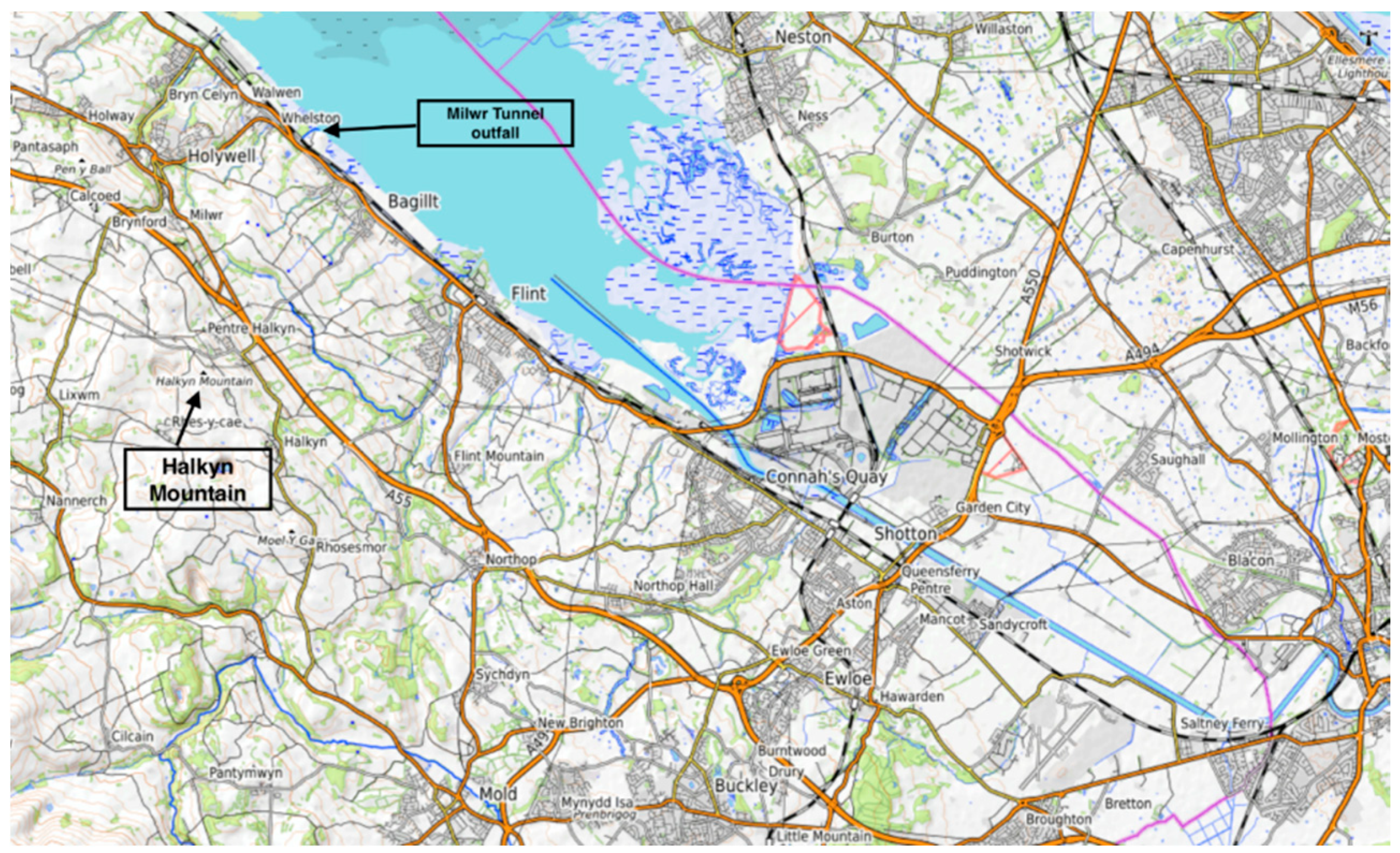
Today, the population around Halkyn Mountain is concentrated in four main villages—Halkyn (with around 2800 people), Pentre Halkyn (approximately 1100 people), Rhosesmor (around 560) and Rhes-y-Cae (some 350). Smaller villages and a number of scattered houses, smallholdings and farms on the edges and slopes also make up the wider area. The village of Brynford, with around 1000 people, and the town of Holywell lie near the plateau’s northeastern edge (
Figure 1). With a population of just under 10,000, Holywell is known for St. Winefride’s Well, a site of pilgrimage renowned for having curative properties. The well was also a central actant in debates during the 1890s and the first two decades of the twentieth century that were concerned with the construction of drainage tunnels and the flow of subterranean water through the limestone geology, and in the narrative and disputes about of the nature and shape of Halkyn’s underground as an extractive frontier of possibility and promise (
Nuttall forthcoming). The Clwydian Hills lie to the west, while farmland underlain by the coal measures make up the Flintshire Coalfield slopes down to the east of Halkyn Mountain. Cut through by the A55 expressway (the main road across North Wales, from Chester to Holyhead), this agricultural land reaches to the towns of Flint and Bagillt and the saltmarsh, mudflats, sands and silt of the Dee Estuary (where the shifting porous border is visible and apparent), which Les Roberts describes aptly as liminal “‘empty’ spaces in-between the coastlines of Wirral (in England) and Flintshire” (
Roberts 2012, p. 104). Halkyn Mountain is surrounded by farmland, but it is an area of mainly common land that has never been enclosed by agricultural improvement schemes. Most of the common land is owned by the Grosvenor Estate, which is under the proprietorship of the Duke of Westminster. Also known as Earl Grosvenor, the Duke’s seat is Eaton Hall, just over the border near Chester.
Writing about the West Virginia coalfields, Kathleen Stewart describes how “the effects of history lie gathered into a space of impacts and remainders storied as a space on the side of the road” (
Stewart 1996, p. 90). This resonates with me as a way of understanding how extractive industry has shaped Halkyn Mountain and its social world and how its surface, depths, minerals and stone have been abstracted, but it also captures how the area remains slightly out of view and hidden to many who pass by on the main roads around it, or is ignored by those who think it has no scenic value as a place for recreation or any intrinsic interest beyond its remnants of mining. For many, Halkyn Mountain does not have the allure of higher hills and peaks. For instance, Moel Famau, a little to the west in the Clwydian Range, and the highest point in Flintshire, is one of the most visited hills in Britain. The Halkyn area is also easily missed by those seeking out the grandeur and imagined wildness of other Welsh mountain landscapes, such as Snowdonia, further to the west. Yet for those who live there and are engaged in its management, history, place, community and nature are immediately present and converge—and often collide.
The plateau is typical limestone country—wonderful for fossil hunting—with outcrops of bare rock, limestone pavement, thin soil and very little surface water. Large caverns and underground lakes lie within its subsurface depths. The earliest mining of metal ores may have occurred in the Halkyn region during both the Bronze and Iron Ages. While precise archaeological evidence for this is lacking, such early extraction would probably have focused on shallow surface workings, with open cuts being made along the line of an ore vein. Mining for lead and silver in the area followed the Roman occupation of Britain, with operations supplying the frontier legionary garrison of Deva (the origin of Chester), which had been established in the AD 70s on the banks of a navigable stretch of the River Dee. Extraction was also significant during the Middle Ages, and lead was in demand during the thirteenth century for roofing the castles built in North Wales during the reign of Edward I (
Ebbs 2008;
Frost and Jones 2004).
Landed families such as the Grosvenors began acquiring mines and mining licences in the early 1600s, and were given rights by the Crown in 1614, which meant they had effective control over much of the industry on Halkyn. A number of Flintshire and Cheshire families became wealthy from lead mining, often by leasing mining rights from the Grosvenors. Many were also involved in smelting and other ancillary industries, such as silver production and silversmith work (
Williams 2012;
Williams and Williams 2012), which were established in nearby towns and villages, especially along the Flintshire shores of the Dee Estuary. The Quaker London Lead Mining Company was also active on Halkyn Mountain for a hundred years from the 1690s. Often in competition and conflict with the Grosvenors, it introduced new mining methods and technologies, erecting a windmill for pumping water and winding ore from the mine shafts and installing (in 1729) an engine house for the first of seven Newcomen steam engines it employed on Halkyn. The company also set about the construction of adits for drainage. This was a mineral-rich region in which other industries, businesses and financial interests were entwined in the production chain of extraction, smelting and transportation. The Port of Chester, on the Welsh-English border, and small harbours along the Dee Estuary were key to the export of lead, and Chester shipping agents and merchants were prominent figures in the lead mining industry that developed not just around Halkyn Mountain, but also in other parts of Flintshire and elsewhere in northeast Wales. Lead products were transported by ships from estuarine ports to other parts of Britain, to Ireland and to global markets, and the region prospered.
As lead miners probed deeper to reach new veins, they encountered a problem familiar to all mining. Water levels rose in shafts and passages, thwarting the extraction of ore but also posing a threat to human life. In the late nineteenth and early twentieth centuries, mine owners and syndicates embarked on ambitious drainage schemes, but the tunnels they constructed provoked local debates about power and privilege, the occupation and ownership of the subterranean through the placing of infrastructure, and concerns over the flow, disruption and contamination of underground watercourses and local water supplies. The major tunnel constructed, the Milwr Tunnel, which was begun in 1897 (
Appleton 1989;
Ebbs 2008;
Frost and Jones 2004;
Nuttall forthcoming) was subject to court cases and parliamentary hearings in which a range of imaginaries about subterranean depths, their material characteristics, lead, limestone, technologies and the entanglements of the human and non-human were at play. The need for drainage tunnels and associated infrastructure was framed by a narrative about promising discoveries of riches in deep, unknown worlds by unwatering abandoned mines and moving further underground to extract ore from new lodes. Just as imperial expeditions across oceans and terrestrial surfaces used images “as key techniques in the processes of investigating, ordering, explaining, and possessing—or attempting to possess—nature” (
Bleichmar 2012, p. 7), maps and models of mines, the depiction of strata and hydrogeological knowledge were essential for the visualisation, discovery, and possession of the vertical interior geographies of northeast Wales (
Nuttall forthcoming; see also
Nystrom 2014). Mining engineers conceptualised and ordered the Halkyn Mountain interior. Their maps, schemata and other technical representations of strata and underground workings gave further impetus to the exploration of these subterranean regions by imagining and abstracting them as resource spaces of great potential. Through these geo-optics and techniques of mapping, making and knowing the underground, spectacular representations of deep, dark places as regions of abundance intimated great returns to those who invested in subsurface mineral zones of promise. The construction of drainage tunnels was viewed as a triumph of engineering in lively, waterlogged limestone underlands. Engineers and miners were celebrated as pioneers and adventurers in unlocking mineral wealth, allowing, in the process, mine owners and tunnel companies to map and control Flintshire’s subterranean frontier (
Nuttall forthcoming).
The last lead mine to be worked on Halkyn Mountain closed in 1987, but while Halkyn is a post-mining landscape it is not quite a post-industrial one. Quarrying was carried out in close proximity to the lead mining activities (
Ellis 1996;
Frost and Jones 2004). Between the late eighteenth and early twentieth centuries, at least six quarries were key suppliers of chert needed for stoneware and porcelain production at the Minton and Wedgwood factories in the Staffordshire potteries. From the 1830s, Halkyn Marble was quarried at Pant-y-Pwll-Dwr (which is the largest quarry still operating). This is a crinoid-rich dark blue limestone that can be polished and was much in demand for ornamental purposes, especially in church architecture (
Haycock 2017). Other quarries produced the hydraulic lime—important because it sets below water—used in the construction of the nineteenth century docks in Liverpool, Birkenhead and Belfast. Several quarries produced limestone for building, and lime-burning was carried out at a number of spots on Halkyn Mountain. Quarrying remains a major activity, with three operations supplying a range of aggregates and asphalt, mainly for construction projects in the local northeast Wales region. From time to time, the quarry operators submit plans for expansion. However, although Halkyn Mountain has been extensively reshaped by the extractive industry, quarrying is scrutinised and subject to strict conditions, designed to protect the very landscape that owes its appearance and form to mining and quarrying (
Silvester 2005). Yet, through the quarrying carried out today, extraction retains an aural and aeolian presence. The quarries are largely hidden from sight as one drives or walks past, but are evident by the noise and dust they generate and from the busy truck traffic transporting the crushed materials along some of the mountain’s narrow roads.
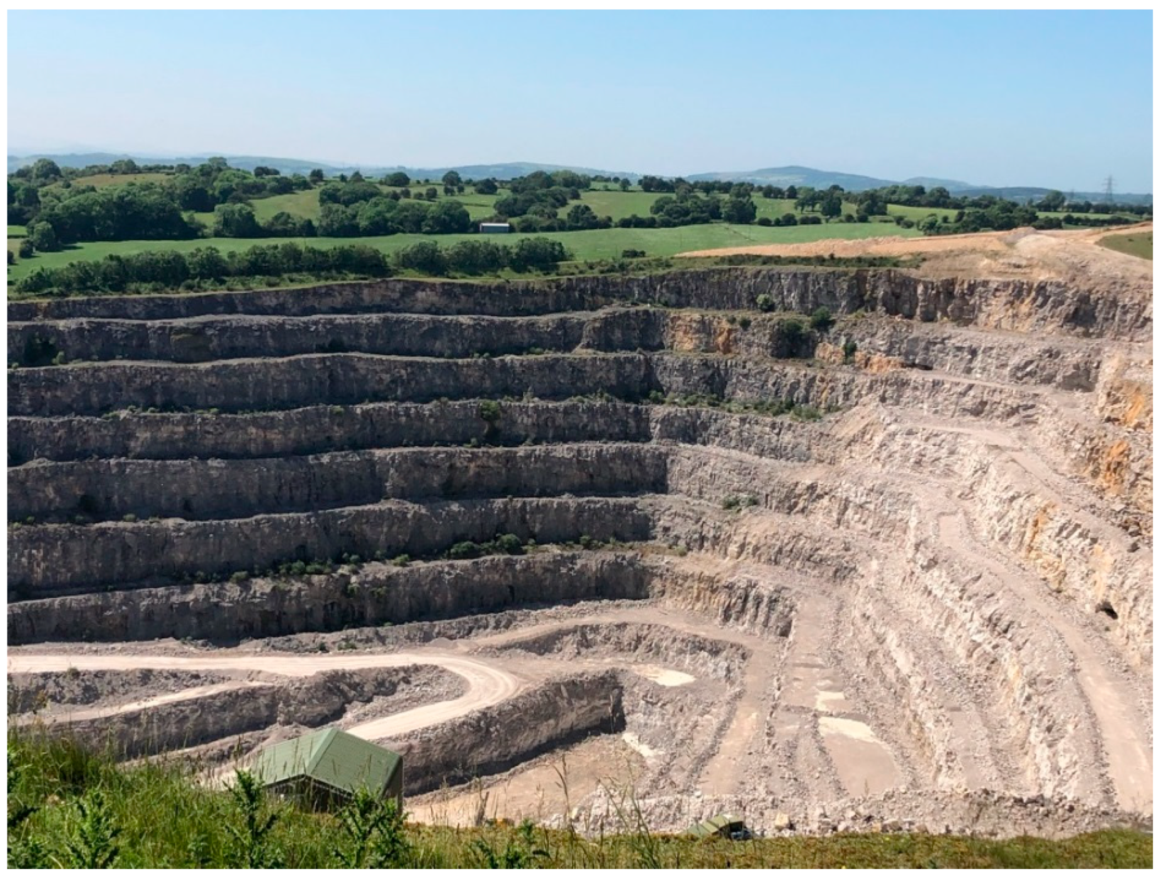
Some 250 major lead mining sites, with thousands of shafts, have been identified in the area (
Coyle 2010). Along with trial pit workings, clusters of spoil heaps and tailings stretching along mineral veins, they survive as evidence of lead mining’s dramatic impact on the landscape and the subsurface (e.g.,
Figure 2). Many shafts have collapsed, and their locations are indicated today by grassy depressions and hollows, often surrounded by humps and mounds of spoil and mine waste, including places where lead was washed. Much of the landscape is overgrown. The grasslands are calcareous, and there is bracken and dry heath. Where surface water can be found drainage is often impeded, and there are some patches of marshy land and wet heath. One needs to be attentive to what is on the ground at all times when walking on Halkyn Mountain; it is easy to trip and stumble into ankle-twisting depressions and shaft craters if one departs from the paths and sheep tracks. To draw on nice wording by John
Wylie (
2006), this is a landscape of depths and folds. Derelict land reclamation schemes have also altered the surface since the 1970s. Large numbers of deep shafts, some of which were also dug for ventilation and drainage, have been infilled and capped by stone and concrete, or covered with iron grates and fenced off. Apart from a few houses and mine offices—some of which have been converted to modern dwellings—most of the buildings associated with mining activities have disappeared. When lead mining declined, in the twentieth century, many structures were left to fall into decay or were removed as the mines closed, although ruined limekilns connected to quarrying and the production of hydraulic lime are now historic sites. Halkyn Mountain itself was designated as a landscape of historic interest (
Jones et al. 2004)—the area also includes prehistoric sites such as Moel y Gaer, an Iron Age hillfort overlooking Rhosesmor. As well as the places where shafts are found, Halkyn Mountain’s surface is pock-marked by the foundation stones of buildings and boundary walls between mining concessions, horse whim circles and leats (artificial water channels), and is criss-crossed by miners’ tracks, paths and traces of old roads and wagonways. It is tempting to call this a leaden landscape—but it is not colourless and dull; a leaded landscape is a more appropriate descriptor, in the sense that its social and economic history, its contemporary nature and its ecology have been bound up with, framed and even weighted with lead.
3. Shaping a Conservation Zone
The extraction of minerals creates cliffs, ledges, crevices and burrows which, along with adits, shafts and grasslands, provide breeding and nesting sites for birds, bats and amphibians (e.g.,
DeVault et al. 2002;
López González and Torres-Morales 2004;
Pauley 2005;
Ratcliffe 1974,
1977), while toxic and calcareous metalliferous spoils provide refugia for metal-tolerant plants of conservation interest (e.g.,
Johnson et al. 1978). As a post-mining landscape, much of Halkyn Mountain now has significant conservation status and is protected for the rare plants and habitats that have emerged from the old mine workings (
Countryside Council for Wales 2008). For example, it has the largest area of calaminarian grassland in northeast Wales—these grasslands are found in former mining areas on nutrient-poor soils that have high levels of toxic metals such as lead, zinc and copper. This is a perfect habitat for plants such as the spring sandwort, a star-like white flower that has a high tolerance of such metal-heavy soil. Miners on Halkyn called it leadwort because it is found where lead lies near the surface. Today, lead washing areas are good spots to look for it. There is an abundance of wild thyme, which also grows well on the places where extracted lead ore was crushed and the waste was washed away. European dry heath, which is comprised of dwarf shrubs including purple and pink heathers and yellow flowering western gorse, also occurs on Halkyn Mountain. And crucially, as I discuss below, it is one of the vital habitat regions in northeast Wales for the endangered great crested newt (
Russell et al. 2017).
Halkyn Mountain’s landscape has been shaped by mining and quarrying and other forms of land use (
Figure 3), but in turn is being shaped and continually produced by land management and by regimes of protection and conservation practice. As in many other British rural areas (e.g., see
Tilley and Cameron-Daum 2017), the area is subject to overlapping management schemes, nature conservation initiatives, development and debates over heathland grazing, recreation, leisure and tourism. It is designated as the Halkyn Common and Holywell Grasslands Site of Special Scientific Interest (SSSI) under UK statutory protection, and the Halkyn Mountain Special Area of Conservation (SAC) under the European Union’s Habitats Directive. The directive protects eight habitat types, including calaminarian grassland and limestone pavement, and one animal species (the aforementioned great crested newt). All of Halkyn Mountain also falls within, but forms the western boundary of, the Holywell Common and Halkyn Mountain Registered Landscape of Outstanding Interest, which is a non-statutory designation. Halkyn Mountain is one element of a wider assemblage of protected places in northeast Wales. The Clwydian Range and Dee Valley Area of Outstanding Natural Beauty (AONB) lies to the west, while to the northeast the Dee Estuary forms a wider marine site constituted by the Dee Estuary/Aber Dyfrdwy Special Area of Conservation, the Dee Estuary Special Protection Area and the Dee Estuary Ramsar Site. Following the UK’s departure from the EU in January 2020, many of the conservation initiatives that are subject to European law are likely to be topics of long debate in the next few years.
Although much of the common land is owned and managed by the Grosvenor Estate, around 200 properties are registered as having ancient commoners’ rights on the Halkyn Mountain Common. The majority of grazing rights relate to the keeping of sheep—some 1500 of them roam on rough, unploughed and unfenced pasture, although grazing rights also exist for cattle, goats, horses and poultry. The common land has been managed traditionally for livestock grazing all year round, and the graziers are organised through the Halkyn Graziers and Commoners Association, while the Halkyn Joint Consultative Board meets quarterly to discuss common management issues; stakeholders represented include the Grosvenor Estate, graziers, community councils, Flintshire County Council, Countryside Council for Wales and local quarry operators. The forum has no statutory powers but provides a platform for the exchange of ideas. The graziers carry out bracken and scrub control—often by burning—on their own patches of common, which are known as hefts, while landscape management over the rest of the common is undertaken by the Halkyn Common Ranger and volunteers or contractors. The number of active graziers has declined in recent years, and those who continue to use the common face problems of overgrazing, and so management schemes are often focused on easing grazing pressure in the places that tend to be overstocked. Graziers feel under pressure, as grazing is not permitted on SSSIs, and they worry and object when plans for quarry expansion are put forward, as they threaten to affect grazing land. One recent project has been a collaborative venture between the local association of graziers and Chester Zoo that would create more suitable grazing conditions for the sheep and allow for the maintenance of favourable conditions for the habitats (and their flora and fauna) that are of national and European importance.
The mountain is a working landscape, but also designated open access land with a right of public access on foot for recreation. This means that people other than those with commoners’ rights can range freely over it, although they are encouraged to keep to paths and other tracks. As with many parts of the British landscape, there is a network of public footpaths and bridleways on Halkyn Mountain, but the commons are also crossed in several places by unfenced public roads (which are also heavily used in parts by quarry vehicles). This often leads to problems and conflicts between traffic and sheep, which tend to wander off the pasture. For many who work on the mountain, public access is often synonymous with public intrusion, especially when people meander from the pathways. Graziers also experience friction with dog walkers, horse riders, mountain bikers and off-road vehicles (the latter are cited by many local people—especially graziers—as being increasingly problematic; and mountain biking is only permitted on bridle ways) and sometimes report that they receive complaints and abuse for burning stretches of heathland as part of approved and traditional management practices. One grazier explained to me that bracken and gorse would spread across the mountain if they were not controlled, and emphasised that graziers and sheep maintain “a unique landscape.” However, visitors will tell them they are destroying the “natural” properties and characteristics of the landscape, without understanding that they are moving across a place transformed and shaped by human activity, as well as by human and non-human gatherings and trajectories (cf.
Tsing 2019), a place that continues to be modified through grazing, extraction and land management. Key to this management has been an ongoing attempt to eradicate invasive aquatic plant species, such as
Crassula helmsii—also known as Australian swamp stonecrop or New Zealand pygmyweed, it has affected great crested newt breeding ponds. Far from being an encounter with the scenic, picturesque and the natural, to be on Halkyn Mountain, as in all landscapes, is to experience and participate in—but also to be confronted and provoked by—this gathering of human and non-human things, processes and relations that are in a process of emergence and becoming as well as conflict and tension (
Bender 2006;
Olwig 1996;
Tilley and Cameron-Daum 2017;
Tsing 2019). On Halkyn Mountain, and in several other parts of Flintshire, this is illustrated by how the great crested newt and its habitat are interwoven in conservation discourse and the regulations surrounding planning for the development of housing, industry and roads.
The great crested newt (
Triturus cristatus) is found in several parts of northern Europe. It breeds in ponds during spring and feeds on invertebrates in woodland, hedgerows, marshes and tussocky grassland throughout the rest of the year. Describing
Ectatomma ants in Panama as “ontological amphibians”, Eben Kirksey argues that, unlike the literal amphibian that lives in water and on land, the ontological amphibian makes choices about the kind of ontology to inhabit (
Kirksey 2015). In a similar way, the great crested newt has particular kinds of preferences, most notably breeding in small to medium sized ponds with extensive vegetation and neutral or slightly alkaline water. A nocturnal amphibian, it hunts and forages by night; any daylight foraging occurs underground in mammal burrows and cracks, but it is more likely to take refuge during the day under rocks, logs and debris (
Langton et al. 2001).
The great crested newt moves between land and water, day and night, but it also moves within—and is implicated in—systems of bureaucracy and regulation. It is also an indicative amphibian, a charismatic sentinel that is considered an important indicator species for plant richness and diversity in ponds and small wetlands, recycling nutrients between water and land (
Gustafson et al. 2006;
O’Brien et al. 2015). Although
Sewell and Griffiths (
2009) argue that a suite of indicators rather than a single species should be examined when assessing indicators of biodiversity and environmental change, the great crested newt is vitally important for aquatic plant diversity (
Black 2017). However, it is in widespread decline, having suffered from the effects of road building, housing development, intensive forestry and mire ditching (
Langton et al. 2001;
Vuorio et al. 2013). As an endangered species, great crested newts and their habitats are protected under Annex IV of the EU’s European Habitats Directive. Achieving Favourable Conservation Status (FCS) for habitats and species is the central aim of the Habitats Directive, and the great crested newt is listed within Annexes II and IV in this regard. This places an obligation on the governments of EU member states to maintain or restore the species at a favourable conservation status. The directive considers the conservation status of a species to be “favourable” when the following criteria are met: population dynamics data indicate that the species is maintaining itself on a long-term basis as a viable component of its natural habitat; the natural range of the species is not being reduced for the foreseeable future; and there is, and will probably continue to be, a sufficiently large habitat to maintain its populations on a long-term basis. This requires the designation of Special Areas of Conservation (SACs), the implementation of a strict monitoring and protection regime, managing habitat linkage, preventing incidental capture and killing and promoting and supporting research. This legislation is implemented in Wales through the Conservation (Natural Habitats, etc.) Regulations 2010 (
Russell et al. 2017). The UK’s departure from the EU means there will be many conservation issues to resolve in the next few years, but great crested newts are already protected in Britain under the Wildlife and Countryside Act (1981)—indeed, it is the UK’s most strictly protected amphibian (
Langton et al. 2001), and both UK and EU laws make it illegal to capture, injure or kill newts intentionally or deliberately, or disturb, damage, destroy or obstruct access to breeding sites and resting places. Although Britain remains a stronghold for this species—it is the largest of the three species of newt found in the UK (the other two native species being the smooth and the palmate)—it is threatened throughout its range in England, Scotland and Wales by habitat loss. Great crested newts have a tendency to move in to the ponds that develop in post-industrial land, or brownfield sites, often because field ponds have been reduced in number by intensive agriculture or other developments.
Northeast Wales, including parts of Flintshire and the neighbouring county borough of Wrexham, has some of Britain’s largest great crested newt populations (
Jehle et al. 2011;
Russell et al. 2017). Lowland parts of Flintshire have a high density of ponds that are suitable as great crested newt habitats. This is due to soil type and the underlying geology, as well as historical farming practices and lead and coal mining. The quarrying of clay for brickmaking around the town of Buckley also left behind enormous depressions in the ground, and some of these pits have filled (or have been filled) with water to form ponds. Flintshire has internationally significant sites for the great crested newt: the Deeside and Buckley Newt Site Special Area of Conservation (SAC), which is comprised of Buckley Clay Pits and Commons (which have taken shape on the sites of former brickworks, with ponds being created for conservation purposes as part of post-industrial reclamation), Connah’s Quay Ponds and Woodlands and Maes y Grug Sites of Special Scientific Interest (SSSI); and Halkyn Mountain SAC, which is comprised of Halkyn Common and Holywell Grasslands and Herward Smithy SSSIs. On Halkyn Mountain, the great crested newt breeds in abandoned quarry workings and other waterbodies. The Welsh Government is obligated to maintain or restore the favourable conservation status of great crested newts within Wales and has acknowledged their decline in Flintshire. Actions concerned with their conservation were included in the Freshwater Habitat Action Plan, which was part of the Flintshire Biodiversity Action produced by the Flintshire Biodiversity Partnership in 2002 (
Russell et al. 2017).
Few people in the UK may have seen a great crested newt in the wild. It also remains elusive to ecologists and conservationists who do population surveys at dusk and night time by torchlight, mainly in the spring, and have to use other techniques such as environmental DNA testing to determine whether a pond contains its essence. However, the great crested newt figures prominently in the regulations for environmental impact assessments and is often in the news when construction projects are not approved by local authorities or are held up because a population has been found to be in the area of a proposed development. New roads, bridges or building developments that threaten to disturb or destroy the places in which great crested newts live or sites where they breed can only be approved if proponents have submitted plans that satisfy local authorities that they will not be disturbed, or that they will relocate them to another suitable habitat if need be. As a retired architect who had spent much of his career dealing with regulations surrounding the possibility of the presence of the great crested newt explained to me, “the regulations are necessary, but the newt is a nuisance for planners.” The great crested newt has become implicated in the bureaucratic procedure of development and permit application processes. In Flintshire, as in other parts of the UK with great crested newt populations, developers must familiarise themselves with a range of documents and texts—which include action plans and mitigation and survey methodologies—that set out the legislation that has emerged from a concern with the lifeworld of the great crested newt and which, in turn, circumscribes and regulates the activities of construction firms, road builders and the like. For example, a developer is required to carry out an assessment to determine whether or not great crested newts are present in a site and must follow the county council’s detailed great crested newt mitigation and monitoring requirements. When there are ponds in the vicinity of the site but no records known of them being great crested newt habitat, then surveys need to be carried out as part of a process called great crested newt likelihood mapping. I have been following the progress of a current plan to build around 100 homes in a small village on the Flintshire-Cheshire border, and this illustrates the process developers have to go through. The proposed development, which is controversial locally and has been opposed by the local community council, would be on a site that contains two ponds with great crested, smooth and palmate newts, and the common frog. The builder submitted documents to Flintshire County Council that outlined the potential environmental impacts of the housing development and this included, for example, a mitigation scheme to minimise the threats posed to the newts as well as a plan for how the company would compensate for the loss of habitat as well as monitor the sites (one suggestion is to maintain the ponds as well as create a new habitat on a disused nearby railway line). This mitigation scheme was presented as a great crested newt development licence method statement in July 2019, something required by Flintshire County Council. The company used the conventional survey methods—torchlight surveys at dusk, bottle trap surveys, an egg search and an environmental DNA, all of which required licences.
A decision on the development is pending, but I mention it briefly as an example of how the presence of the great crested newt can appear almost as a provocation, impede progress and confront and frustrate the plans of builders and developers. For conservationists, however, it represents what Jamie
Lorimer (
2007) writes about when he discusses the importance of non-human charisma in imagining and mobilising flagship and indicator species for biodiversity monitoring, and what Cheryl
Lousley (
2016) refers to as charismatic life to describe representations of nature that emphasise vitality and vibrancy. Paul
Evans (
2018) calls the great crested newt enigmatic, and describes it as living a beguiling existence between the liminal space between earth and water. I argue that it also occupies and moves within and between the bureaucratic spaces in which habitat regulations and planning procedures and conservation actions are formulated, negotiated and implemented, and which must satisfy the needs of regulators and conservation and environmental protection, as well as the ambitions of developers eager to build houses and government planners who want to get roads constructed. About 17 cm long, it could be grouped together with other charismatic microfauna, such as butterflies, or other amphibians. It brings to mind Emily
Wanderer’s (
2018) discussion of how the axolotl, a species of salamander native to the canals of Xochimilco, a neighbourhood of Mexico City, is a charismatic species with deep connections to Mexican history and identity (it is also cultivated in scientific laboratories researching developmental and regenerative biology). In the wild it is, as Wanderer shows, a sentinel species that is indicative of the fragility of the environment. In Flintshire, the great crested newt is, like the axolotl, also regarded as a sentinel species, but it can hardly be said to have deep connections to social, cultural or national identity in northeast Wales—at least not yet. However, it is a key actant in narratives about the health of post-industrial landscapes, and its lifeworld is deeply connected to the recent environmental history of the county and the designation of sites considered ecologically and scientifically important. There are spaces with which it is inextricably linked and which are infused with its essence. This is especially apparent on Halkyn Mountain and in the ponds that have formed from the claypits in the former brickmaking sites around Buckley a few miles to the southeast, and which are close to new housing developments. Moreover, I have observed how local residents celebrate the success of great crested newt relocations in ponds created specifically for the purpose on reclaimed land—in this way, the county council is able to point to the way amphibians and humans can, and do, co-exist following building projects as a conservation success story; but for local residents, even if many of them never actually see great crested newts, what is important is knowing that a particular pond is defined by their presence. On Halkyn Mountain and elsewhere in Flintshire, the vitality of the great crested newt population is essential if favourable conservation status is to be achieved, but it is also an indicator of the area’s vibrancy and biodiversity and essential to the definition of the area as a site of special scientific interest. It plays a role similar to the one Anna
Boswell (
2020) describes for the tuatara—the New Zealand spiny-backed lizard—as an icon of biodiversity under threat. However, the great crested newt is enrolled in conservationist discourses that shape the character of Halkyn Mountain and other places in the county rather than being brought into dialogue about interspecies co-existence. What matters is that protective measures are seen to bring the great crested newt closer to favourable conservation status. On Halkyn Mountain—and this warrants further investigation—for conservationists and county council departments, great crested newts are not considered non-human participants that dwell on (and within) the mountain, bringing it into being along with humans and other non-human beings and entities whose trajectories overlap, intersect and intermingle (cf.
Kirksey 2015;
Nuttall 2017;
Reinert 2015;
Tsing 2019).
4. Community and Heritage on Halkyn Mountain
The remains of mining activity and places ruined by extraction have become re-signified as industrial and cultural heritage sites in many places around the world (
Orange 2008;
Peyton 2017;
Rhatigan 2020;
Staniscia and Yuill 2017). Their designation and management as such—especially for touristic consumption—can affect the daily lives of those who live within and adjacent to them (
Sinnett and Sardo 2020;
Sonter et al. 2018). Historical mining associations and local authorities concern themselves with the preservation and conservation of abandoned mines, quarries, waste hillocks and mining structures. In doing so, mining is often memorialised as a noble enterprise that has contributed to nation-building or the breaking down of frontiers, but this risks the erasure of community memories associated with living, working and engaging with materials such as lead and coal (cf.
Edensor 2005). In this article and in other writings, I have pointed to how Halkyn Mountain has a rich social and economic history which makes for a multilayered landscape above and below ground, in which people and their activities have left their traces (
Nuttall forthcoming), and investigating this further will be key to further research in the area. I am also interested in the kinds of controversies that arise from how to treat this history and its social, economic and health effects and how they illustrate the contested nature of land use and landscape management (cf.
Keulartz 2016;
Orange 2008;
Peyton 2017;
Storm 2014). As in other British lead mining landscapes, such as the Peak District in Derbyshire (
Barnatt et al. 2013), historic mining sites have become conservation assets just as Halkyn Mountain has. Once designated as such, these ruined places are, in turn, often threatened by remediation schemes, development and agricultural improvement (Barnatt et al. ibid.). As David Robertson shows in a study of mining sites in the United States, not all former mines and abandoned mining towns are seen as places of dereliction and decay, but can be reimagined as relics of a romanticised frontier history that forms the basis for heritage tourism and recreation (
Robertson 2006). Mining may have dramatic impacts on landscapes, transforming them through the removal and replacement of surface ecosystems and subsurface strata (
Bridge 2004;
Rotherham et al. 2012, p. 34), but, writing about coal mines in West Virginia,
Stewart (
1996, p. 137) talks of how “[t]he detritus of history piled high on the local landscape has become central to a sense of place emergent in re-remembered ruins and pieced together fragments.” Spoil heaps become heritage and their removal can be a source of anxiety for local communities, heritage managers and conservationists alike. Getting rid of the spoil can spoil the look of an area that has come to depend on the derelict.
History is important for the communities on Halkyn Mountain—and understanding how this is so is central to much of my current research. Its lead mining heritage is commemorated and celebrated in guided walks, local events and annual heritage weeks. The Halkyn Mountain Community Council, local community groups and conservation organisations do much to emphasise how the contemporary nature and the future of the area are bound up with its extractive past and the legacies evident in the landscape. This matters, as local residents tend to think and talk about the Halkyn Mountain area as being different from surrounding rural areas and nearby towns. However, the mountain has not been turned into an open air museum like the Minera lead mines a few miles south, in the county of Wrexham. With a restored engine house fitted with replica machinery as its centrepiece, the old Minera site forms part of the waymarked Clywedog Trail, which takes walkers around the industrial heritage of an area that was once filled with lead mines, iron works, paper mills and corn mills. On Halkyn Mountain, one has to walk around and allow the area’s extractive history to reveal itself without signposts. One can get below the surface, but access to the subterranean is only possible for cavers; however, getting below the surface is not just an act of adventure, it is also a matter of historical investigation. Of course, there are well-trodden walking routes, and many appear in walking guides to the region or are linked together as discovery trails in educational resource packs used by local schools for history and geography projects. Regular guided walks are also organised from a local pub in the village of Halkyn, and there is an active Halkyn Mountain Conservation Group which encourages people to take an interest in the mountain’s flora and fauna, but the area’s story is not told through interpretive signs with informative text along guided paths. Information about lead mining and quarrying is posted in certain areas, such as at the Waen-y-Brodlas limekilns, which were the focus of restoration work in 2013 (
Figure 4), but most of the more apparent signs that are placed around the area warn of the danger of mineshafts, telling people to keep away—perhaps a far more explicit indication of what went on above and below the surface. For
Stewart (
1996, p. 93), “ruins become the collective presence of the place and are read as
signs to be plumbed for significance.” Although there are many different interests in the area’s history, ecology and conservation, Halkyn Mountain has escaped the kind of controversy discussed by
Sandberg (
2014), when a disused limestone quarry in southern Sweden became a contested site caught between a process of environmental gentrification, which threatened to turn it into a “gated ecology”, and a campaign to designate it as a nature reserve with public access. Instead, a sustainable management scheme, which receives funding from the Welsh government, and the Halkyn Mountain Living Landscape Project, which has European funding, aims to protect the area’s ecology by managing grazing, controlling invasive species and enhancing community engagement with the mountain.
While Halkyn Mountain is a landscape ruined, reshaped and made by mining and quarrying, my broader interest—which is the focus of my ongoing research—is with understanding it within a wider region of ruination. Many Flintshire towns and neighbourhoods, especially in the Deeside conurbation, have experienced significant economic decline with the loss of major industry over the last 30–40 years. The end of lead mining, coal mining, brickworks and other industries in Flintshire—and, in particular, the stream-lining of the steel industry on Deeside (for example, 6500 workers were made redundant by British Steel at its Shotton plant on a single day in March 1980)—has, in turn, reshaped the socio-economic character and circumstances of the county. Many towns and rural communities, especially along the Dee Estuary shore, have experienced severe economic decline and high levels of unemployment and deprivation over the last few decades. The lead mines, brickworks, collieries, smelters, mills and shipyards may now be gone, but much of the Deeside region (including other neighbouring parts of Flintshire and Cheshire) is still an industrialised landscape. Major sites include the Connah’s Quay Power Station, Dee Power Station, the Tata Steelworks (the former British Steel site), a Toyota engine plant, a paper mill, cement works and the Airbus aircraft wing factory at Broughton. Flintshire County Council has encouraged investment in manufacturing, especially in schemes located in the Deeside Industrial Estate, and part of the region is being re-imagined as an enterprise zone and centre for finance. The council has also focused on the development of Flintshire as the centre of the UK’s aerospace industry—although in 2020 the Covid-19 pandemic has cast a shadow over the region, given that several thousand people face redundancy because of the uncertainty over the future of air travel and the consequences for aircraft manufacture. In June 2020, Airbus announced that it would be cutting 1700 jobs at its UK factories, including several hundred at the Broughton wing factory, and other aerospace companies in the area indicated that they too would be making redundancies. A reminder of how vulnerable a region can be to shocks in global supply chains—in this case from a virus that is disrupting and disassembling complex global systems.
The legacies of industrial decline are apparent in many Flintshire towns and neighbourhoods, despite county council and Welsh government economic investment, regeneration plans and the growth of enterprise zones and business parks. I follow Alice Mah’s approach of understanding industrial landscapes of ruination as “inhabited landscapes in which people live through processes of change” (
Mah 2012, p. 13). For Mah, ruination as a lived process is one through which people experience transformation often as rupture and loss, while Anna
Storm (
2014) argues that the scars etched on post-industrial landscapes are shaped by time and geographical scale; they carry, she writes powerfully, the vestiges of people’s lives and their work, of community spirit and hope, of betrayed dreams and repressive hierarchical structures. The recasting of history and places as heritage sites often try to erase those scars and memories, but they run deep in a place like Flintshire.
As Gavin Bridge has written, art, literature and travellers’ accounts often portray and describe mines as disrupting “the natural sublime or terminating a pastoral idyll” (
Bridge 2004, p. 243). In many travellers’ accounts of journeys made in North Wales from the late eighteenth century and into the twentieth century, mining and quarrying landscapes were to be largely avoided by those who went in search of the picturesque, and extractive industry was considered intrusive and ruinous. For example, Thomas Pennant, who was himself from Flintshire, had little to say about Halkyn Mountain as a place of scenic beauty. In
A Tour in Wales, Pennant described the land to the east of the Halkyn area as rising suddenly from the shore of the Dee Estuary—initially “clayey, and plenteous in corn and grass, for two, three or four miles, to a mountainous tract that runs parallel to it for a considerable way” (
Pennant 1778, p. 2). Pennant wrote that “The lower part is divided by picturesque dingles, which run from the mountain, and open to the sea, filled with oaks. The inferior parts abound with coal and freestone; the upper with minerals of lead and calamine, and immense strata of limestone and chert. The principal trade of the country is mining and smelting” (
Pennant 1778, p. 3). Gazing and reflecting upon ruins were central to the experience of the early touristic encounter, but the interest was in a Wales filled with prehistoric, early Christian, medieval and mythical ruins rather than an interest in viewing the dereliction of landscapes of extractive industry. This characterised the Romantic period of mainly pedestrian travel in Wales, but later travellers were also disappointed by finding mines, slag heaps and smokestacks in the hills and the valleys, across the border from industrial England. In the 1920s, F. J.
Snell (
1928, p. 25) wrote of the Welsh-English borderlands as having mountains with “a solemn grandeur” and hills “enchanting in their repose”, often topped with “grey ruins” and which “give the last touch to the sense of romance” (1928, p. 25). However, he warned the reader intending to travel there that:
Some may harbour an uneasy sentiment that entrance into those favoured districts is not altogether to fly the depressing influence of industrial conditions, which, however, essential to the national well-being, most commonly connote ugliness, the defacement of kindly Nature. Honesty compels us to admit that the Borderland is not quite exempt from this taint. At Wrexham, for example, there are coal mines, and in the sector at Kidderminster the manufacturing activity of the Midlands stretches its tentacles to the banks of the Severn.
(Snell ibid.)
Snell went in search of, and described, the unspoilt—“peaceful scenes” and the “varied charms of hills and mountains, wood and water”—“the ample spaces in which such reminders of mechanical progress do not intrude” (ibid.). Yet he could not avoid industry entirely. In the final chapter of the book, describing a journey from Welshpool to Chester, Snell wrote about the country house and estate of Wynnstay Park near Ruabon, calling it a “pleasaunce on the verge of an industrial desert of collieries, ironworks, terra-cotta and brick factories.” “From the scarred hill-side of Cefn,” he wrote, “evidences of grimy, but honourable toil attend us on our way to Ruabon, and there we are not quit of them” (Snell ibid., p. 304). He encountered “more collieries” between Ruabon and Wrexham and, describing the “malodorous effects arising from the presence of breweries and tanneries and other works that cannot be carried on without diffusing pungent vapours,” he felt of the latter town that “it is not exactly a place to fire the enthusiasm of a pilgrim in search of beauty” (ibid., p. 306). Snell made brief mention of the area around Mold, which is Flintshire’s county town, calling it “remarkable for its mineral wealth—coal and lead principally” (ibid., p. 310) before going on to point out that many relics of antiquity—Druidic circles, Roman roads and encampments, and the Saxon earthworks—are to be found in the district. And, while being “on the confines of Cheshire and within sight of Chester”, Snell described the village of Hawarden as being in “the far less prepossessing region of Flintshire.” “We shall therefore say no more about the village and concentrate our attention on the Castle and its demesne” (ibid., p. 311).
To someone who does not know Halkyn Mountain, but who begins to learn a little of its history and contemporary character, it may begin to reveal itself as a contradiction (I recall, for example, a conversation I had with a mountain biker who could not understand why a place “ruined” by mining and “full of quarries” was in need of protection). For one thing, some may dispute that Halkyn Mountain is a mountain, and say that it is a low-lying hill, without perhaps understanding (if they are non-Welsh speakers) that
mynydd is also a toponymic designation for commons in Wales rather than a misnomer. It has been dug into and quarried out, with the underground claimed and ownership rights assigned to mining companies, but much of its surface area is common land. This land has never been enclosed and cultivated, but it has nonetheless been grazed intensively (even overgrazed) and burned according to ancient custom—and these commoners’ rights restrict any kind of agricultural “improvement” anyway. Halkyn Mountain has been shaped by the forces that have given form to its underlying limestone geology, and it has been sculpted and polluted by extractive industry, yet plants and animals benefit from its contaminated soils, even if the toxic legacy of mining remains a concern for environmental and human health (
Flintshire County Council 2013). The wounds and scars left by extraction are now valuable assets for Halkyn’s status as an industrial heritage area, although this heritage is threatened by the expansion of quarrying and other forms of land use. A few thousand people live on and around Halkyn Mountain, but it is also attractive as a site for outdoor recreation (below ground, shafts, levels and subterranean passages are popular with cavers too) and is subject to framings of wildness and scientific interest, and even the occasional rewilding imaginings of it as a feral place. Abandoned mining sites are reminders of an industry that has intruded upon what are seen to have once been natural, unspoilt places, and their reclamation becomes a key policy objective for environmental management. Yet, as Ben
Marsh (
1987) has pointed out with reference to defunct anthracite mining towns in Pennsylvania, while former (and ruined) mining areas may not necessarily be attractive in an aesthetic sense, they can have emotional significance to those who live in and around them and for whom a sense of place emerges from the extractive past. Landscapes that have been radically altered, reshaped and formed by extraction can become special in other ways too, and Joern
Langhorst (
2014) points out that ecology emerges as a redemptive agent for
post-post-industrial places. Ruined, disturbed, destabilised former mines, quarries and other industrial landscapes assume importance for biodiversity and are protected as conservation assets or as sites for experiments in ecological restoration (e.g.,
Gross 2016). On Halkyn Mountain, this is illustrated by the way species rendered endangered or special that have found a niche in the emergent landforms and habitats of the mountain’s old metal mining spaces give it meaning as a vital site for biodiversity and conservation.
Halkyn Mountain was once a productive environment shaped by extractive capitalism—especially in the late nineteenth and early twentieth centuries. While land on the mountain that has been damaged by mining activities has not been subject to the kind of reclamation schemes implemented in many former mining sites elsewhere in the UK, the mountain’s old mining sites, which themselves have contributed to enormous landscape and environmental change, have become sites of special scientific interest and wildlife refuges, of local, national and international significance. Proposals to redevelop them have met with resistance because they threaten, in turn, to bring change to landscapes that have already been altered and transformed (as well as subject to ancient rights tied to the commons), and reshaped as vibrant ecological spaces animated by things that are special such as plants and newts. Halkyn Mountain as contradiction is exactly what a landscape is—something made, remade, contested, political, hard to define—reminding us of how nothing about what we think of as “landscape” and “countryside” is “natural” and has been created over centuries of human use (e.g.,
Bender 2006;
Massey 2006;
Pryor 2010;
Tilley and Cameron-Daum 2017); a provocation (
Massey 2006) and a product of the gathering, meeting up and intertwining of human and non-human trajectories (
Kirksey 2015;
Tilley 2010;
Tsing 2019). In setting out to understand how this is so, this article represents the beginning of a larger research project, a contribution to a much longer and rich story to be told about Halkyn Mountain, an upland common which constitutes a small part of northeast Wales, and what it can tell us about the shaping of landscapes, the history of extractive industries, how people have peered and ventured into the subsurface, how they have moved along and below, the creation and maintenance of place, community and identity, contemporary notions of wild landscapes and how the human and non-human are caught up in contested ideas of conservation and use of the countryside.


