Article

Urbanization in Algeria: Toward a More Balanced and Sustainable Urban Network?

1
Department of Social Geography and Regional Development, University of Debrecen, Egyetem tér 1, H-4032 Debrecen, Hungary
2
Department of Physical Geography and Geoinformatics, University of Debrecen, Egyetem tér 1, H-4032 Debrecen, Hungary
*
Author to whom correspondence should be addressed.
Soc. Sci. 2023, 12(3), 174; https://doi.org/10.3390/socsci12030174
Submission received: 11 January 2023 / Revised: 10 March 2023 / Accepted: 12 March 2023 / Published: 14 March 2023

Abstract

:
Before colonization, Algeria was primarily a rural country with a nomadic and semi-nomadic population. However, significant changes occurred during and after the colonial era as modernization efforts were implemented. This paper provides a regional overview of Algeria’s pre-and post-millennium urban development based on census population data expressing the quantitative side of urbanization. Our analysis focuses on three aspects: regional structural tendencies of urbanization, sources of urban growth, and the current state of Algeria’s urban network. We contextualize our findings by comparing them with the existing literature and the priorities outlined in the country’s National Spatial Development Plan 2025. Our research suggests that: (1) First-stage (concentration) and second-stage (suburbanization) urbanization features, as well as internally and externally determined development, characterize Algeria’s urban network. (2) A decreasing and regionally differentiated urban growth rate indicating a moderate shift towards non-coastal regions and the above-average dynamics of large cities and smaller towns can be observed. (3) The significance of natural growth as a source of urbanization is higher than the contributions of rural-urban migration and new “de jure” towns. However, these factors are differentiated among the regions, highlighting the secondary role of rural-urban migration in the internal peripheries and the importance of new “de jure” towns in the densely populated and urbanized northern regions. (4) Algeria’s urban network is divided into three sharply differentiated zones that have experienced only moderate changes. We regard this shift toward a spatially more balanced urban network as a factor supporting but not guaranteeing sustainable development.

1. Introduction

Urbanization, a growing mass and proportion of the population living in cities and towns, has been a rapid phenomenon in recent times (Annez and Buckley 2009). Less than 200 million people, representing 15% of the world’s population, lived in cities in 1900 (Zinkina et al. 2017), but the situation changed dramatically during the 20th century. About 3.6 billion (51%) urban dwellers were registered worldwide in 2010 (World Economic and Social Survey 2010 2010), and with the current trends, the world’s urban population is estimated to reach 6.3 billion (70%) by 2050 (United Nations 2018). Urbanization is a defining feature of the Maghreb region in North Africa, encompassing Algeria, Morocco, and Tunisia. While the region has a long history of urban living, similar to other emerging regions, modern urbanization gained momentum in the latter half of the 20th century.
The urban growth and development of the Maghreb countries share common features in terms of their physical and geographical attributes. However, the primary factors shaping the urbanization processes are the economic and social policies that underpin them (Belguidoum et al. 2015). An urban network, defined as a system of interdependent cities and towns connected by different linkages at various spatial scales (Ducruet 2020), is characterized by a spatial imbalance in the region of Maghreb countries. On the one hand, due to the geographical constraints imposed by the Sahara desert and the region’s fragmented relief, the Maghreb turned towards the Mediterranean, where most economic activities and significant agricultural zones are found (Fargues 1995). On the other hand, the spatially uneven growth of urban areas in the Maghreb region can also be attributed to various socio-economic factors, such as earlier colonial policies that prioritized the exploitation of agricultural and mineral resources in the area (Bardinet 1977).
Like the neighboring Maghreb countries, the Algerian urban network is concentrated in the coastal regions and largely contributes to the spatial inequalities of population distribution. More than 63% of the inhabitants live in the North (4% of the area), while the South (83%) only accommodates 9% of the population. The consequences of these imbalances are manifold. The concentration of infrastructure and economic activities in the North increases spatial socio-economic inequalities in terms of consumption, income, welfare, and working conditions, resulting in an escalating housing crisis, construction on fertile lands, loss of cultural identity, increased insecurity and crime, declining quality of life, and the spread of diseases. Additionally, the development of urban areas has led to a devaluation of rural areas and associated jobs, as well as issues related to mobility, water distribution, environmental degradation, and the growing exposure of urban settlements to natural hazards. Scholars such as Belkhatir (1999) and Côte (1988) have raised these problems rooted in spatially uneven urbanization. A more balanced distribution of development and population now constitutes the great challenge that the regional planning policy in Algeria—like in many other countries—must face. This challenge has been tackled elsewhere, as evidenced by various regional and urban policies in countries such as Brazil and China. These policies aimed to promote a more balanced urban network and foster environmentally sustainable socio-economic development in spatial terms (Pereira 1991; Huang et al. 2020). However, emerging environmental conflicts in the cited countries show that a spatially more balanced urban network is not necessarily more sustainable (Ulgiati and Zucaro 2019; Liu et al. 2014). Consequently, the first one (though the more rational use of natural resources gives the possibility for their renewal) can be regarded rather as a support than a guarantee for the latter.
In the context of the spatially uneven urban and regional development in Algeria and the Maghreb as a key problem, our article focuses on answering the following questions:
  • Which regional and structural urbanization tendencies can be identified in Algeria based on the last censuses during the decades at the turn of the millennium?
  • Which sources of growth play a role in urbanization?
  • Which regional and structural differences in the urban network can be observed as a result of the processes? Is the emerging spatial pattern more balanced and sustainable?
By answering these questions and comparing our findings with some key points of the urbanization literature, earlier local experience, and also with the priorities of the National Spatial Development Plan (SNAT 2025) launched by the Algerian state to reduce regional imbalances, we not only identify and understand urbanization tendencies but also evaluate them in the context of regional development. Furthermore, our Algerian case study offers the possibility for future comparative analyses on urban network development within and beyond the borders of the studied (Maghreb) region.
We divided the article into four main parts between the introduction and conclusion. In the first part (Section 2), we examine the existing literature dealing with uneven urban development and its socioeconomic and environmental consequences, with special attention to the processes in Algeria. In the second part (Section 3), we present our research material and methods. The third part (Section 4) presents the results of our examination related to the first question and is organized into three subsections. Finally, in the discussion of the fourth part (Section 5), we compare our results with earlier findings, examine the identified processes through the lens of SNAT 2025 (2008), and put the spatial-structural development of the Algerian urban network into a broader context.

2. Theoretical Background

Urbanization is a twofold process. On the one hand, it is the concentration of population in cities or urban areas (Tisdale 1941), known as the quantitative side of urbanization. On the other hand, the concept describes the spread of urban life, businesses, government infrastructure, civil society organizations, and the associated culture in the urban and rural space (Kumar 2017), representing the qualitative side of urbanization. Natural population growth, rural-urban migration, the growing number of “de jure” towns, and the incorporation of former rural settlements by the geographic expansion of cities can all contribute to (quantitative) urbanization, although the rates of natural population growth in urban areas are generally lower than in rural areas; therefore, they cannot generate a shift toward a larger share of urban population alone (Kojima 1996; Cohen 2006).
Urbanization has different stages with considerable spatial and temporal variability in different countries and regions; according to Champion (2001), it has four stages. The first stage is linked to the movement of the rural population to urban centers, to a geographic concentration of economic and residential activities, often in a monocentric form. The second stage results from the negative effects of concentration, such as industrial pollution, accidents, exploited natural resources, and elimination of agricultural lands because of the development of new areas for housing, social communities, and commercial and other use (Zhang 2016). Consequently, a more decentralized and polycentric urban structure marked by intra-metropolitan dispersion (suburbanization) of economic and residential activities emerges. In the third stage, this deconcentration process expands from the primary and intermediate-sized cities towards small urban and rural settlements, which may grow faster than the primary or intermediate-sized cities (counter-urbanization). By the end of this stage, the urban system has reached a “saturation point” of small centers (Pacione 2005). The fourth stage is re-urbanization, defined as the social and physical reconstruction of suburban areas into urban ones (Manis 1959), or more efficiently, the growth of population in major cities after a longer period of population loss (Brombach et al. 2014).
There are different models of spatial development and hierarchy of urban networks. Table 1 compares the characteristic features of two well-known concepts: the model of Walter Christaller describes the internal differentiation of local marketplaces. In contrast, the model of James E. Vance interprets the development of an urban network based on external relations within the frame of the capitalist world economy. We think that a combination of these two models can help us interpret the urbanization processes in the Maghreb region where recent urban network developments shaped by national state policies are based on colonial heritage and carried out in a globalizing world economy. While the model of Christaller was earlier adapted in several countries to lay the foundation for urban network development policies targeting a more balanced structure, the model of Vance is rather about the realities of an externally influenced and uneven urbanization.
Urbanization in Africa is predominantly in the first (concentration) stage. It is characterized by unplanned and unregulated growth exacerbated by the legacy of past colonialism and the consequences of recent neoliberalism that produced weak urban planning institutions. In many African countries, the urban network is extremely monocentric: one city, usually the capital, has many times more population, economic activity, and political power than the next largest city. The challenges urban areas in Africa face are among the biggest in the world regarding the lack of basic urban services. The reasons for mismanagement and inadequate infrastructure are colonial institutional arrangements and persistent political instability. Some African countries do not have any departments of urban planning and development, while the strict zoning in the central regions of many cities inadvertently contributes to the proliferation of slums and the sprawling development of residential areas (Elmqvist et al. 2013).
According to the study of Jager and Arrif (1998), two main phenomena characterize the recent urbanization in the Mediterranean countries. First, coastal regions are preferred over the inland, leading to a concentration of population in large metropolitan areas located along the coast. Second, the general migration growth towards the coast is driven by economic factors. The three Maghreb countries have some similarities in their evolution. They are open to the Mediterranean, as well as deeply marked by the Arab-Muslim civilization and the French colonization (Valette 1975). The region represents a homogeneous block with a high urbanization level, and a functionally developed urban network turned towards the coast. Rapid urbanization occurs primarily along the Mediterranean coast, where the administrative, infrastructural, institutional, economic, and socio-cultural development is rooted in natural and historical assets, which can be traced back to the effects of colonialism. Harvey (1973), Doherty (1977), and Bardinet (1977) have argued that the outward-oriented urban network was a crucial instrument for colonial exploitation. This network was primarily designed to facilitate the efficient transportation of exportable agricultural and mineral resources to the global market. The policy resulted in a new urban hierarchy with the most preferred cities located at the end of or along the major rail lines and waterways. In the case of Morocco, Abu-Lughod (1989) observed that, as opposed to the precolonial system in which Marrakesh and Fez had prominent positions, Casablanca and Rabat-Sale came to dominate during the colonization. These observations suggest that certain aspects of Vance’s model are present, where the spatial distribution and hierarchy of urban settlements are shaped by external trade connections that prioritize transport routes and gateway cities.
Our case study on Algeria shows spectacularly that urbanization intensified only after the colonial period (Côte 1994). Valette (1975) describes Algeria as a country with low urbanization but large cities before the colonial period. According to Sanson (1979), Algeria had a noteworthy urban history prior to the colonial era, but there was no uninterrupted urban tradition inherited from this period. Rather, the history of Algerian cities is one characterized by repeated changes of rulers and foreign influence. Following an annual growth rate of 2–2.5% in the colonial era, a remarkable surge in urbanization (10.2% annually) occurred during and immediately after the war of independence in the 1950s and 1960s. This spectacular increase resulted from internal migration generated by insecurity during the war and the population exchange of Algerian cities left by the European settlers. Subsequent to this dynamic period, the pace of urbanization decelerated, with a tendency towards slower growth rates. According to the general population and housing census, average annual increases in urban population were 3.2% (1966–1977), 3.1% (1977–1987), 2.1% (1987–1998), and 1.7% (1998–2008).
Scholarly works exist which examine the evolution of the urban system in Algeria. The position of Algiers in the urban hierarchy has been the subject of an investigation by Marc Côte (1978). Côte contends that the capital city’s status is anomalous within the urban hierarchy of Algeria, as its labor force surpasses that of the secondary city of Oran by a factor of three. He discussed five principal ideas that characterized Algerian urbanization in the years immediately following independence (Côte 1994). These were: (1) a marked increase in the pace of urbanization; (2) urbanization driven primarily by the influx of rural migrants to urban areas; (3) a concentration of urbanization in coastal regions; (4) the emergence of industrial hubs, particularly in major urban centers and the capital; and (5) an urban hierarchy that was precarious in its foundation, as it lacked smaller urban centers to support it. According to Aziz Belkhatir (1999), Algeria shall give answers to three challenges: (1) disarticulation and economic under-integration of cities; (2) economic and human hyper-concentration in the Tell; and (3) desertification and marginalization in the rest of the state territory. According to the author, a potential solution to the challenges facing Algerian urbanization could involve four key components: (1) rapid and massive urbanization generated by modernization; (2) a competitive market economy “with human face”; (3) a more harmonious transport and communication infrastructure network; and (4) the multiplication of decision-makers (decentralization). Meanwhile, Djamel Raham et al. (2004) attempt to shed light on the principles of the administrative division in Algeria (in general), especially in eastern Algeria, describing the main imbalances. They highlight that any territorial reorganization should consider spatial, social, and economic factors and prioritize marginal areas to reduce imbalances between subregional units. To achieve this, they propose a need for increased urban network density, transport infrastructure development, improved accessibility and communication, the implementation of socio-economic development projects, and the establishment of regional-level institutions. Finally, the study of Kamel Kateb (2003) identifies a great contrast between the main coastal agglomerations concentrating activities, skilled labor, and infrastructure, and the rest of the country being relatively under-equipped and poor. On the other hand, it finds that the proportion of the sparse population continues to decrease, while the concentration of population in the growing number of urban settlements goes hand in hand with the increasing share of small and medium-sized towns.
In the next section, we step further and present the key feature of our case study.

3. Study Area, Research Materials, and Methods

Algeria is located in the Southern Mediterranean, in North-West Africa, and in the center of the Maghreb (Figure 1). With a total size of 2,381,741 km2, Algeria is ranked as the 10th largest country in the world and the largest country in Africa. It comprises three major geographical zones: the coast and the Tell in the North, the Highlands, and the Sahara in the South (Jules 1859). With an average density of around 12 inhabitants/km2 in 1998 and close to 15 inhabitants/km2 in 2008 (Table 2), Algeria cannot be regarded as an overpopulated country. However, the average value hides great disparities between the three main areas. In 2008, the population of the North was estimated to be about 21.5 million, which gives a density of 209 inhabitants/km2. At the same time, about 3.2 million inhabitants and a population density of 1.64 inhabitants/km2 were registered in the South. The Highlands, with 30.75 inhabitants/km2, took an intermediate position (Table 2). This unequal population distribution is even more emphasized at the level of provinces or municipalities. Nearly 70% of the population lives in metropoles and large cities. Population densities in large cities are higher, particularly due to industrial activities.
However, how is “urban” defined in Algeria? According to Act 06-06 (2006), a concentration is defined as urban if it has an agglomerated population of at least 5000 inhabitants. According to article number 4 of the above act, any urban concentration with a minimum population and administrative, economic, social, and cultural functions can be considered a “city.” Act 01-20 (2001) links the definition of urban settlements with regional planning and sustainability. In doing so, the act introduces a range of conceptual definitions, including metropole, metropolitan area, big city, new city, and sensitive urban zone. On the other hand, Act 06-06 (2006) defines the concepts of a medium-sized city, small town, and urban concentration (Table 3) and indicates in article number 5 that cities can also be classified based on their functions and influence on the local, regional, national and international level, as well as on their historical, cultural and architectural heritage.
The National Spatial Development Plan (SNAT 2025) provided an overview of the regional priorities of the state, as established by Act 87-03 (Loi no 87-03 du 27 janvier 1987 relative à l’aménagement du territoire 1987) and Act 01-20 (2001) and was adopted in 2008. This plan gives the spatial framework for our regional examination. The document outlines the state’s strategies for reducing spatial inequalities and enhancing the attractiveness of the preferred regions in the next two decades within the context of sustainable development (Saidi and Saidi 2022). Sustainability appears on two levels in the document. The first (whole) priority focuses on this issue and includes sub-priorities of sustainable water usage, soil conservation and desertification control, preservation of ecosystems, control of major risks, and the protection of cultural heritage. While the second priority, spatial rebalancing, integrates the sustainability approach into its sub-priorities on a (lower) level. SNAT is partly based on a coordinated action within the neighboring provinces shaping nine programming regions (North Centre, North East, North West, Highlands Centre, Highlands East, Highlands West, South East, South West, and Hoggar Tassili regions). According to article number 41 of Act 87-03 (1987), each region has more provinces that share similar geomorphological characteristics and/or demonstrate complementarity (relationships) in the use of natural resources and cooperate in their planning and development activities. The analysis of regional urbanization patterns in Algeria is based on census data collected in 1987, 1998, and 2008 (ONS n.d.) (as it is the last census until now, and the census, which was supposed to take place in 2018, was postponed to September 2022 because of COVID-19 and financial issues but has yet to be summarized), which provide a homogeneous database in terms of spatial and settlement size structure for the decades immediately preceding and following the turn of the millennium. The current administrative division of the country, which includes 48 provinces, was established in 1984 in response to changing spatial realities. Aggregated values for the nine programming regions were generated from provincial data to identify the spatial pattern of urbanization within the framework of the SNAT. Unfortunately, we did not have recent data (i.e., the SNAT began in the same year as the most recent census). We present the results of our analysis using tables and figures (including charts and maps), with the maps edited using ArcMap software version 10.4.

4. Results

4.1. Regional Tendencies in Urbanization

Based on our data, the number of urban settlements increased by 65% between 1987 and 1998, although this growth was unevenly distributed across the country. About 80% of the new towns were located in the three northern regions, and the Highland East, the latter region saw the greatest absolute and relative growth in urbanization during this period (Table 4 and Table 5). On the contrary, there were no new urban settlements in the Hoggar Tassili region. The urban population also increased by 58% during this period, with more than 75% of the absolute growth concentrated in the three northern regions and the Highland East. The Highland regions exhibited above-average relative growth in their urban population, while the Hoggar-Tassili region’s high relative growth was not as visible due to its small local urban population. In terms of urban network and the urban population growth, the former was slightly more dynamic, with population concentration mainly occurring in some Highland and southern regions (Table 4 and Table 5).
There is a structural similarity among the three northern regions as they are the only areas where metropoles are found. However, there are differences in the urbanization dynamics of these regions. In the North Centre, the smallest urban settlements experienced the most intensive growth, while large or medium-sized towns in the other two northern regions showed a larger increase. The Highland regions focused on expanding their urban network by emphasizing the growth of the smallest urban settlements. In addition, during the decade, two of the three regions witnessed the emergence of a new category of large cities (Table 4 and Table 5). In two southern regions, small towns had above-average growth rates, with the South East experiencing one-fifth of the national urban population growth in this category. The South East also saw spectacular growth in large cities. By the end of the 20th century, the urban network remained incomplete below the metropole level in the South West and, particularly, in the Hoggar-Tassili region. This region witnessed the birth of a medium-sized town alongside the smallest urban settlements. These findings suggest a varied urbanization pattern across regions, with some regions emphasizing the growth of smaller urban settlements while others prioritized the development of larger towns and cities (Table 4 and Table 5).
What changed during the next decade (1998–2008)? Compared to the previous period, there was a national-level slowdown in the growth of both urban network density and urban population. This trend was observed in almost every region, except for Hoggar Tassili regarding the number of urban settlements and the South West regarding urban population growth rate. Furthermore, there was a tendency towards greater population concentration within the urban network. The majority of the new urban settlements (80%) and urban population growth (56%) were concentrated in the northern regions with average or under-average urban population dynamics. This growth pattern was more spatially concentrated in terms of new urban settlements and less concentrated in terms of urban population than in the previous period. The North Centre showed one of the highest growth rates in the number of urban settlements but the lowest urban population growth rate. These tendencies may indicate a suburbanization process, with a spatial extension of urbanization around the capital city (Table 6 and Table 7).
Approximately 20% of the urban settlements’ growth and almost one-third of the urban population can be attributed to the Highland regions, especially the Highland Centre and Highland East. These regions have demonstrated an above-average increase in urban population, with the Highland Centre experiencing the most significant growth. Although urban population growth in the southern regions had the highest rate, the expansion of the urban network was only notable in the Hoggar Tassili region, while in the South East, there was a decline in the number of urban settlements with more than 5000 inhabitants. In contrast to the suburbanization tendencies of the North Centre, the urban population growth outpaced the expansion of the urban network in all other regions. This difference was especially prominent in the Highland and two southern regions, highlighting the presence of an urban concentration process (Table 6 and Table 7).
Concerning the urban structure, it is critical to reiterate that metropoles only played a role in the urbanization of the northern regions and even experienced a decline in population in the North East. In line with the aforementioned suburbanization trends, the most dynamic categories of the urban network were found small or medium-sized towns. Indeed, 80% of the total population growth in small Algerian towns occurred in these areas, especially in the North Centre region, where 50% of the growth was registered. Large cities in two Highland regions, the Highland Centre and Highland East exhibited remarkable dynamics, accounting for more than 50% of the total population growth of large cities. Meanwhile, medium-sized towns dominated the Highland West. The Highland Centre, similar to the northern regions, experienced a secondary growth maximum in the category of small towns. The Hoggar-Tassili region remained the only one without large cities, with a strong emphasis on small towns’ growth rate, while two other southern regions registered the highest growth rate of medium-sized towns (Table 6 and Table 7).
Upon comparison of the tables, it is evident that out of the nine regions, only two demonstrated the highest dynamics in the largest local size category of urban settlements. At the national level, it is worth noting that large cities showed the highest dynamics during the two decades, surpassing even the metropoles. Primary cities in the Highland Centre and Hoggar Tassili regions registered the highest population growth rate in their category in both periods, highlighting the persistence of urban development over time (Table 4 and Table 6).

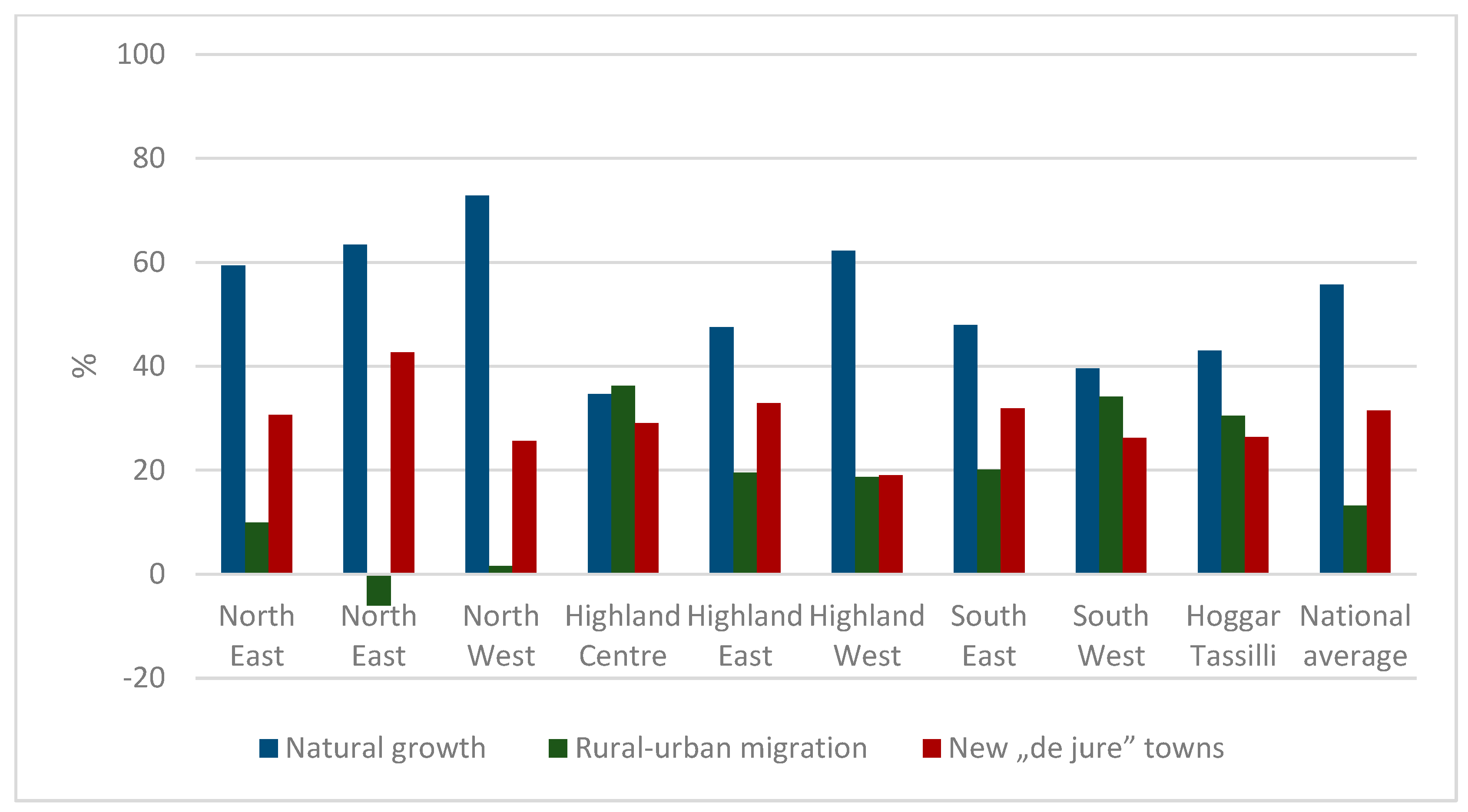
4.2. Sources of Urban Growth

What kind of processes can we find in the background of this regionally uneven urban development? As earlier mentioned, urban growth is influenced by various factors such as natural growth, rural-urban migration, the growing number of “de jure” towns, and integrated rural settlements resulting from urban sprawl. Although only three categories can be distinguished due to the data structure in our empirical research, natural growth emerged as the dominant contributor to urban growth in both decades. Rural-urban migration, on the other hand, was found to have a substantial impact in the Highland Centre and in the Hoggar-Tassili region during the first decade (Figure 2 and Figure 3).
The findings of this study may be surprising, but they are not necessarily contrary to the previous research that has shown differences in the rates of natural growth between urban and rural areas (Côte 1994). While natural growth does not explain changes in the relative proportions of urban and rural populations, it is the primary factor driving absolute urban population growth. This is true even though the natural growth rate in Algeria has declined during the period studied. Rural-urban migration, mainly comprising younger people, can also contribute to the growing fertility of the target settlements, thereby indirectly boosting local natural growth. The secondary sources of urban population growth are more varied. On a national level, the growing number of “de jure” towns is more critical than rural-urban migration to older cities and towns, and its importance is growing. However, it is worth noting that by treating new “de jure” towns as a separate category, we may underestimate the importance of rural-urban migration because the latter remains hidden when target settlements become “de jure” urban in the examined period. The regional tendencies also vary: in the urbanized northern regions, the extension of the urban network through new “de jure” towns is more important, while in the Highland and Southern regions, rural-urban migration plays a more decisive role. Despite a general trend toward the extension of the urban network, migration continued to play a crucial role in the second decade (Figure 2 and Figure 3). A detailed explanation of their urban growth patterns is provided below.
Firstly, French colonialism substantially altered Algeria’s built environment and fundamentally reconfigured the country during the Algerian Revolution (1954–1962) by establishing new infrastructure and settlements throughout the country (Hadjri and Osmani 2004; Bekkouche and Otmane 2022). In addition, the colonial regime enacted several laws and orders to control the Algerian residents by a forced transfer to certain settlements, especially in the northern part of the country, because of its endowments: port sites, higher speed communication with Europe, rich agricultural plains, mild climate, and welcoming beaches. These regional imbalances between the North and the South, between the city and the countryside, accelerated the process of urbanization in the colonized northern territory, especially in the main cities. However, these spatial imbalances continued even after independence and were sometimes reinforced by the policy of administrative centralization and the concentration of significant investments in the northern regions because of the availability of the most critical infrastructures and assets.
Secondly, the urbanization pattern in Algeria was largely influenced by economic development policy. During the central planning era, the state aimed to modernize and rebalance the country’s spatial distribution (of population and economic activities) by establishing new industrial centers, such as Batna in Highland East, M’sila in Highland Centre, Saïda and Tiaret in Highland West, Adrar in the South West, and Hassi-Messaoud and Hassi R’Mel in the South East, which became primary targets of rural-urban migration. However, many public manufacturing enterprises were unable to compete due to outdated management practices and technologies, and their losses had to be compensated by the public budget, leading to increased external debt and slowed economic growth. To secure external financial support, Algeria liberalized its economy under the guidance of the International Monetary Fund (Herizi and Bettioui 2016), resulting in the restructuring of the economy and the closure of several industrial companies that employed thousands of workers. For example, since 1994, 935 of the 1324 local public enterprises scattered across the country (and employing nearly 220,000 people) have been closed down. M’sila in the Highland Centre lost three-quarters of its 10,000 industrial jobs in 2000. As a result, rural-urban migration in regions where these companies were located has been curtailed, and new migratory movements have emerged toward coastal metropoles with stronger economic potential, which also might appreciate urban-urban migration. However, the Saharan regions have seen renewed attractiveness due to the dynamic economic development driven by private actors in agriculture, manufacturing, petroleum, and the tertiary sector. An example of notable progress and rejuvenation includes the oasis renewal in the agricultural sector and growth in the petroleum industry facilitated by the involvement of domestic and foreign entities.
Thirdly, Algeria faced economic and political challenges that led to an unstable environment during the period under examination. The civil war between 1987 and 1998 caused a “Black Decade” with approximately 200,000 fatalities, thousands of whom went missing, and hundreds of thousands who were either displaced or exiled. Forty-three percent of the armed actions in the North Centre, 12% in the North West and the Highland West regions, and 4.3% in the North East region were carried out (Kateb 2004). As a result, about 1.5 million Algerians were forced to flee their villages between 1993 and 1997. More than 100,000 went to live in the suburbs of towns like Djelfa (Highland Centre), Médéa, and Chlef (North Centre). Many villages, including Ouled Ali, near the capital, were abandoned, and about 1.5 million Algerians were forced to flee their villages between 1993 and 1997 (Kouaouci and Rabah 2013). Only a portion of this migration was classified as rural-urban migration, with the majority of individuals settling in the suburbs of Algerian cities. However, the population growth observed in small towns with inhabitants between 5000–50,000 can be attributed to their proximity to rural areas, which made them a preferred destination for those seeking security (Chadli and Hadjiedj 2003; Bousmaha et al. 2021).
Fourthly, policies aimed at moderating the growth of metropoles were implemented, such as the destruction of precarious housing in the major cities, social housing programs outside of cities, and the blocking of industrial investments. These policies resulted in the creation of new “de jure” towns in the northern regions, including Bab Ezzouar, Boumerdès, and Dar el Beida near Algiers, and Sidi Amar near Annaba, among others. One notable example is Ali Mendjeli, which was established on the outskirts of Constantine in 2000 (Lakehal 2015) as a solution to the city’s landslides and high demand for social housing (Foura and Foura 2005). The number of social housing applicants in Constantine was 32,000 per year, and due to the dynamic natural increase, the construction of a new city was seen as the best solution to the problem. Ali Mendjeli grew from 0 inhabitants in 1998 to 64,120 inhabitants by 2008. The establishment of Ali Mendjeli had an effect on the balance of rural-urban migration as well as on the contribution of new “de jure” towns to the urban population growth in the North East region.

4.3. The Recent Urban Network of Algeria

As a result of the urban development tendencies above, three distinct urban zones can be identified in contemporary Algeria, as shown in Table 8. The Northern Coastal Zone had a high urban network density and population concentration, while the Highland Zone had a medium-level urban network density and population concentration. The Southern Saharan Zone, on the other hand, had a low urban network density and population concentration. Notably, each zone had a unique region that stands out: the North Centre which includes the capital city of Algiers, the Highland East, which has been the site of significant socio-economic development efforts since the war of independence (Raham 2001), and the South East, where urbanization is closely linked to the growth of the oil and gas industry (Côte 2005). In terms of metropolitan areas, these are only found in the northern regions, with Algiers, Oran, Constantine, and Annaba serving as primary cities. A majority of the large and medium-sized towns are also found in the northern regions (Figure 4). While the population share of large cities was more dominant in certain Highland and Southern regions, the Hoggar Tassili region in the center of the Sahara desert has no metropoles or large cities, and its primary city is a medium-sized town, Tamanrasset, which is home to more than 50% of the regional urban population. Interestingly, there have been no changes in the primary city status of these regions between 1987 and 2008, indicating the conservative character of the urban network.
Based on a comparison of the size distribution of the Algerian urban settlements and the expected distribution according to Zipf’s law describing the situation regarded as optimal, it is evident that there is a deficiency in the case of the larger cities (Figure 5). Algiers, with a population of 2.36 million, is three times more populous than the second-largest city, Oran. Although the combined population of the five cities following Algiers—Oran, Constantine, Annaba, Blida, and Batna—is 2.04 million, this is still lower than that of the capital city. This finding indicates that the Algerian urban system is a macrocephalic system (Bousmaha et al. 2021). However, it is important to note that monocentric urban networks are also prevalent in other regions, including emerging economies and European countries, as reported in several studies (Molnár et al. 2022; Sami et al. 2021; Mariana 2016; Burger 2011). The two graphs depicting the size distribution of urban settlements exhibit an inversion in position around the 20th place, indicating that the group of smaller towns and the smallest urban settlements forming the base of the urban network are relatively well-developed, according to Zipf’s law (Figure 5). These small towns and smallest urban settlements ranging from 5000–50,000 inhabitants, play a critical role in the Algerian urban network, accommodating 40–60% of the total urban population across all regions, from the Highland Centre to the South East (Table 8). Urban development activities have traditionally focused on implementing national (re)construction projects and meeting the population’s basic infrastructure, equipment, and housing demands, leading to the establishment and growth of new urban settlements. However, the high urbanization rate in Algeria is concentrated around the metropoles, such as Algiers (94.3%), Oran (92.4%), Constantine (89.2%), and Annaba (84.1%). Meanwhile, a substantial concentration of urban inhabitants can be observed in the Saharan provinces of Ghardaia (96.2%), Tindouf (92.8%), and Ouargla (82.4%).

5. Discussion

Comparing our findings to the literature, we argue that Algeria is still in the first (concentration) stage of urbanization, also showing some elements of the second (suburbanization) stage around the northern metropoles. Our results on the slowing urbanization rate, the secondary importance of rural-urban migration, the moderate shift of urban development towards non-coastal regions as well as the dynamics and importance of small towns and smallest urban settlements partially contradict the earlier findings about the increased pace of urbanization, urbanization driven primarily by rural-urban migration, the concentration of urbanization in the coastal regions, and the lack of small urban centers (Côte 1994) demonstrating a shift in urbanization tendencies over the last two decades. However, this shift is rather moderate due to physical geographical realities and the conservative nature of the settlement network resulting in limited changes in the spatial distribution of the total and urban population. In this way, the problems discussed by Marc Côte (1978, 1994), Aziz Belkhatir (1999), and Djamel Raham et al. (2004) related to the Algerian urban network and regional development are still relevant. On the other hand, our results show the importance of smaller towns and the smallest urban settlements constituting about 50% of the total urban population in every region. This aligns with the findings of Kamel Kateb (2003) and draws attention to the importance of future research within this group of Algerian urban settlements.
In order to deal with the heritage of colonialism and the development of the subsequent decades resulted in large regional imbalances and tensions, SNAT 2025 (2008) aims to achieve spatial rebalancing by reducing disparities in the distribution of population and economic activities and by relieving the pressure on the densely populated coastal regions. Within its second (spatial) priority framework, the document identifies three regional and two thematic sub-priorities aimed at promoting spatial development. The regional sub-priorities are focused on the development of the northern coastal regions, the Highlands, and the southern desert area. It is worth noting that environmental considerations, including land use, ecosystem protection, and prevention of natural and industrial risks, are integrated into these sub-priorities on a lower level. The approach is also place-based, as seen in the action plans for the Highlands and the development concept for the South, which takes into account the unique characteristics of the desert environment and the needs of its inhabitants. Regional and thematic priorities are intertwined: relocation of economic activities and public administration, as well as the development of the urban network, serve as tools to achieve the regional priorities.
In terms of changing patterns of urbanization, the concept of a rebalanced urban network is particularly significant, as shown in Figure 6. SNAT 2025 (2008) identifies certain types of urban centers as key priorities, including metropolitan regions (4), growth centers in the Tell region (9), counterbalancing centers in the Highland (10), and development centers in the South (12). The goal is to strengthen and improve these 35 centers. The metropoles are hubs for production, services, research, and executive functions and are connected not only to each other but also to major cities worldwide, serving as gateways. The growth centers in the Tell region manage and facilitate development in their area by establishing urban-rural linkages in order to reduce the pressure on coastal metropolitan zones. The counterbalancing centers on the Highland contribute to a spatial extension of the population growth by organizing their rural base. The development centers of the South are economic and service locations stimulating growth and enhancing the attractiveness of the South. There are also three types of new towns having different emphases on their functions depending on their location (Tell, Highland, or South). Besides centers reducing the pressure on metropoles (Tell), extending the growth (Highland), or exploiting the local resources (South), bringing urban life deeper into the continent, the spatial connections have a special importance. The traditional North-South transport axles link coastal centers to internal peripheral regions, while the growing significance of East-West infrastructure contributes to urban networking and strengthens horizontal relations within a system historically characterized by vertical relations rooted in the colonial era. The deconcentration of economic activities and public administration as a tool for a more balanced urban network development, the strengthening of urban-rural linkages, and the establishment of an infrastructure overwriting the existing spatial asymmetries show toward an urban network staying closer to the concept of the Christaller model.
Our findings about the slow shift of urban dynamics towards non-coastal regions are also supported by the population change data of the prioritized urban categories of SNAT. Counterbalancing towns of the Highland and development towns of the South have more rapid population growth than metropoles or new growth towns in the Tell during both decades, while there are also differences between the coastline and its direct hinterland (Tell). In this approach, SNAT aims to strengthen existing spatial tendencies. On the other hand, the population of the prioritized cities and towns had mostly lower dynamics than the national urban population during both decades. It is also due to the significant contribution of new “de jure” towns to the urban population growth discussed earlier. In order to minimize the distortion effects of this latter settlement group, we revised the data by neglecting the contribution of new “de jure” towns based on our information about the sources of urban population growth. However, even compared to these data, the dynamics of the prioritized urban centers seem to be above the average only in the case of the counterbalancing towns of the Highland and the development towns of the South. In this context, SNAT aims to modify the existing spatial urbanization tendencies (Table 9).

6. Conclusions

In our paper, we gave an overview of urban development in Algeria from a regional perspective, both before and after the turn of the millennium. We began by introducing the relevant literature and our research methodology, which relied on the data from the last three censuses. We then examined the topic through three questions: we dealt with (1) spatial and structural tendencies of urbanization, (2) sources of urban population growth, and (3) a recent analysis of the urban network. Regarding the first question, our results pointed to a slowing but regionally differentiated urban growth rate with a moderate urbanization shift towards non-coastal regions and above-average dynamics of large cities and smaller towns. In the framework of the second question, we identified the primary importance of natural growth exceeding the contribution of rural-urban migration and new “de jure” towns as well as the differentiation of these factors among the regions emphasizing the secondary role of new “de jure” towns in the densely settled and urbanized northern regions, and the importance of rural-urban migration in the internal peripheries. In a broader context, the legacy of colonialism, the economic and urban development policy of the young Algerian state, and the effects of the civil war together played a role in creating the background of urbanization. Answering the third question, we highlighted three sharply differentiated zones of urban network density and urban size structure. The urban network generally shows deficits in large cities and a robust basis in smaller towns. In the discussion, we placed our findings in a broader context by comparing them to the existing literature and the priorities of the national spatial development plan. Accordingly, Algerian urban development can be characterized as the first stage of urbanization, with some tendencies of the second stage observed around the coastal metropoles. This development has been historically influenced by externally determined factors, particularly the role of gateway cities (ports) based on the legacy of colonization (modeled by the theory of Vance), as well as by the efforts of the young Algerian state to achieve regionally more balanced urbanization and foster urban-rural interactions (in their expectations staying closer to the urban hierarchy of Christaller). We regard the realized shift toward a spatially more balanced urban network as a factor supporting but not guaranteeing sustainable development. The question of sustainability remained open; we need more specific indices to assess the developments from this point of view.
Our article will give a plus to the urban field research because it contains empirics about urban network development from a country (Algeria) that is underrepresented in the international literature, and it was synthesized and put into the broader theoretical context of the existing literature about the country and connecting the questions of urbanization and regional development policy. However, our research is limited by the fact that the most recent census data available were collected in 2008. The planned 2018 census was delayed due to COVID-19 and financial issues, but it has recently begun (in September 2022), which may allow us to update our findings with new statistics and assess the real impact of SNAT 2025 (2008) on the spatial development of the urban network.

Author Contributions

Conceptualization, F.A.S.; Methodology, F.A.S.; Software, F.A.S.; Validation, E.M.; Formal analysis, F.A.S.; Resources, F.A.S.; Writing—original draft, K.P.; Writing—review & editing, F.A.S. and E.M.; Visualization, F.A.S.; Supervision, E.M. All authors have read and agreed to the published version of the manuscript.

Funding

This research was funded by the University of Debrecen.

Institutional Review Board Statement

Not applicable.

Informed Consent Statement

Not applicable.

Data Availability Statement

The data presented in this study are available on request from the corresponding author.

Conflicts of Interest

The authors declare no conflict of interest.

References

  1. Abu-Lughod, Janet. 1989. Urban Structure under Decolonization: The Factorial Ecolog Sale, Morocco. In Report of the 1976 Social Science Research Council Conference on North African Urbanism. Princeton: Princeton University Press. [Google Scholar]
  2. Annez, Patricia Clarke, and Robert Buckley. 2009. Urbanization and growth: Setting the context. Urbanization and Growth 1: 1–45. [Google Scholar]
  3. Bardinet, Claude. 1977. City responsibilities in the structural dependence of sub-industrialized economies in Africa. Antipode 9: 43–48. [Google Scholar] [CrossRef]
  4. Bekkouche, Asmaa, and Tayeb Otmane. 2022. Structural and functional transformations of an intermediate city and the emergence of commercial strips, the case of Tiaret in Algeria. Cybergeo: European Journal of Geography, 1036. [Google Scholar] [CrossRef]
  5. Belguidoum, Saïd, Raffaele Cattedra, and Aziz Iraki. 2015. Cities and Urbanity in the Maghreb. Anneemaghreb: Journal of Openedition 12: 11–32. [Google Scholar] [CrossRef]
  6. Belkhatir, Aziz. 1999. Villes et territoires en Algérie. Méditerranée 91: 73–84. [Google Scholar] [CrossRef]
  7. Bousmaha, Ahmed, Aissa Boulkaibet, and Yacine Kouba. 2021. Dynamique des villes en Algerie. application du critère de la taille des villes selon le modèle hiérarchique de «la loi de zipf». In 2ème Colloque International: Les Villes Petites et Moyennes Dans Un Monde Globalisé. Quel Avenir Face à La Métropolisation? pp. 28–47. Available online: https://www.researchgate.net/publication/359349189 (accessed on 2 November 2021).
  8. Brombach, Karoline, Johann Jessen, and Philipp Zakrzewski. 2014. Reurbanization in Metropolitan Regions in the US and Germany—Comparing Apples and Oranges? AESOP Conference. Available online: https://www.researchgate.net/publication/303922946_REURBANIZATION_IN_METROPOLITAN_REGIONS_IN_THE_US_AND_GERMANY_ (accessed on 2 November 2021).
  9. Burger, Martijn. 2011. Structure and Cooptition in Urban Networks. ERIM Ph.d. Series Research in Management; Rotterdam: Erasmus Research Institute of Management. Available online: http://hdl.handle.net/1765/26178. (accessed on 12 September 2021).
  10. Chadli, Mohamed, and Ali Hadjiedj. 2003. L’apport des petites agglomerations dans lacroissance urbaine en Algerie. CyberGeo 251: 1–10. [Google Scholar] [CrossRef]
  11. Champion, Tony. 2001. Urbanization, Suburbanization, Counterurbanization and Reurbanization. In Handbook of Urban Studies. London: SAGE Publication, pp. 143–61. Available online: https://www.academia.edu/637295/Urbanization_suburbanization_counterurbanization_and_reurbanization (accessed on 12 September 2021).
  12. Cohen, Barney. 2006. Urbanization in developing countries: Current trends, future projections, and key challenges for sustainability. Technology in Society 28: 63–80. [Google Scholar] [CrossRef]
  13. Côte, Marc. 1978. Alger et sa place dans la hiérarchie. Villes En Parallèle 2: 7–17. [Google Scholar] [CrossRef]
  14. Côte, Marc. 1988. L’Algérie ou L’espace Retourné. Paris: Flammarion. [Google Scholar]
  15. Côte, Marc. 1994. L’urbanisation en Algérie: Idées reçues et réalités. Travaux de l’Institut de Géographie de Reims 85: 59–72. [Google Scholar] [CrossRef]
  16. Côte, Marc. 2005. La ville et le désert: Le bas-Sahara algérien (Karthala Éditions). Available online: https://books.google.hu/books?hl=fr&lr=&id=dgB_sYxkWbEC&oi=fnd&pg=PA5&dq=related:wS5SsoQfD1sJ:scholar.google.com/&ots=ULcpeV8n40&sig=- (accessed on 10 November 2021).
  17. Doherty, Joe. 1977. Urban Places and Third World Development: The Case of Tanzania. Antipode 9: 32–42. [Google Scholar] [CrossRef]
  18. Ducruet, César. 2020. Urban network. In AAG. International Encyclopedia of Geography. Paris: Centre National de la Recherche Scientifique (CNRS). [Google Scholar] [CrossRef]
  19. Elmqvist, Thomas, Michail Fragkias, Julie Goodness, and Burak Güneralp. 2013. Urbanization, Biodiversity and Ecosystem Services: Challenges and Opportunities: A Global Assessment. Available online: https://library.oapen.org/bitstream/handle/20.500.12657/28058/2013_Book_UrbanizationBiodiversityAndEco.pdf?sequence=1 (accessed on 24 June 2013).
  20. Fargues, Philippe. 1995. L’urbanisation du monde arabe: Un éclairage démographique. Journals Openedition Ema 22: 43–62. [Google Scholar] [CrossRef] [Green Version]
  21. Foura, Mohamed, and Yasmina Foura. 2005. Ville nouvelle ou Zhun à grande échelle ? L’exemple d’Ali Mendjeli à Constantine. Les Annales de La Recherche Urbaine 98: 122–26. [Google Scholar] [CrossRef]
  22. Hadjri, Karim, and Mohamed Osmani. 2004. The spatial developmentand urban transformation of colonial and postcolonial Algiers. In Planning Middle Eastern Cities: An Urban Kaleidoscope. London: Routledge. [Google Scholar] [CrossRef]
  23. Harvey, David. 1973. Social Justice and the City. London: Edward Arnold. [Google Scholar]
  24. Herizi, Ratiba, and Djamila Bettioui. 2016. Local industrial development in Algeria. Journal of Business and Retail Management Research (JBRMR) 10: 3. Available online: https://www.researchgate.net/publication/306315586_Local_industrial_development_in_Algeria (accessed on 21 March 2022).
  25. Huang, Daquan, Yue Lang, and Tao Liu. 2020. Evolving population distribution in China’s border regions: Spatial differences, driving forces and policy implications. PLoS ONE 15: e0240592. [Google Scholar] [CrossRef]
  26. Jager, Jean-Claude, and Abdelmajid Arrif. 1998. Urbanisation du Littoral Méditerranéen. Marseille: Centre de documentation de l’urbanisme. [Google Scholar]
  27. Jules, Duval. 1859. l’Algérie “Tableau Historique, Descriptif et Statistique”. Paris: Lib. Hachette et Cie. Available online: https://books.google.com.sg/books/about/L_Alg%C3%A9rie.html?id=IQJQAAAAYAAJ&redir_esc=y (accessed on 20 September 2020).
  28. Kateb, Kamel. 2003. Population et organisation de l’espace en Algérie. Espace Geographique 32: 311–31. [Google Scholar] [CrossRef]
  29. Kateb, Kamel. 2004. Violences politiques et migrations en Algérie. In Les Migrations Internationales Observation, Analyse et Perspectives. Budapest: Association internationale des démographes de langue française, pp. 557–71. Available online: https://www.erudit.org/fr/livres/actes-des-colloques-de-lassociation-internationale-des-demographes-de-langue-francaise/les-migrations-internationales-observation-analyse-perspectives-actes-colloque/001388co/ (accessed on 20 September 2020).
  30. Kojima, Reeitsu. 1996. Introduction: Population migration and urbanization in developing countries. The Developing Economies 34: 349–69. [Google Scholar] [CrossRef] [Green Version]
  31. Kouaouci, Ali, and Saadi Rabah. 2013. La reconstruction des dynamiques démographiques locales en Algérie (1987-2008) par des techniques d’estimation indirecte. Cahiers Québécois de Démographie 42: 101–32. [Google Scholar] [CrossRef]
  32. Kumar, Ashok. 2017. Urbanization [in The Wiley Blackwell Encyclopedia of Social Theory]. Wiley Blackwell Encyclopedia of Social Theory. Available online: https://www.academia.edu/8586061/Urbanization_in_The_Wiley_Blackwell_Encyclopedia_of_Social_Theory_ (accessed on 25 October 2021).
  33. Lakehal, Ahcène. 2015. Rôle des habitants dans l’invention de nouvelles formes d’urbanité dans la périphérie de Constantine (Algérie). Le cas de la ville nouvelle Ali Mendjeli. L’Année du Maghreb 12: 35–53. [Google Scholar] [CrossRef]
  34. Liu, Hongling, Guanghong Zhou, Ronald Wennersten, and Björn Frostell. 2014. Analysis of sustainable urban development approaches in China. Habitat International 41: 24–32. [Google Scholar] [CrossRef]
  35. Loi n° 01-20 du 12 décembre 2001 relative à l’aménagement et au développement durable du territoire. 2001. Journal Officiel de l’Algérie. Algerie. Available online: https://www.informea.org/fr/node/207952 (accessed on 11 September 2022).
  36. Loi n°06-06 du 20 février 2006 portant loi d’orientation de la ville. 2006. Journal Officiel Algérie. Available online: https://ruralm.hypotheses.org/1065 (accessed on 11 September 2022).
  37. Loi no 87-03 du 27 janvier 1987 relative à l’aménagement du territoire. 1987. Journal Officiel Algérie. Available online: https://www.ecolex.org/fr/details/legislation/loi-no-87-03-relative-a-lamenagement-du-territoire-lex-faoc004625/ (accessed on 11 September 2022).
  38. Manis, Jerome. 1959. Annexation: The Process of Reurbanization. The American Journal of Economics and Sociology 18: 353–60. [Google Scholar] [CrossRef]
  39. Mariana, Kotzeva. 2016. Urban Europe. Statistics on Cities, Towns and Suburbs. Luxembourg: European Union. [Google Scholar] [CrossRef]
  40. Molnár, Ernő, Feyrouz Ahlam Saidi, and Katalin Szabó. 2022. Strategic coupling on the European periphery: A case study of a small Hungarian town. Tér és Társadalom 36: 3. [Google Scholar] [CrossRef]
  41. ONS: Office National des Statistiques. n.d. Available online: https://www.ons.dz/ (accessed on 15 December 2021).
  42. Pacione, Michael. 2005. Urban Geography: A Global Perspective. New York: Routledge. [Google Scholar]
  43. Pereira, Luiz Bresser. 1991. Populism and Economic Policy in Brazil. Journal of Interamerican Studies and World Affairs 33: 1–22. [Google Scholar] [CrossRef]
  44. Raham, Djamel. 2001. Les Structures Spatiales de l’Est Algérien. Les Maillages Territoriaux, Urbains et Routiers. Available online: https://www.researchgate.net/publication/32227545_Les_Structures_Spatiales_de_l%27Est_Algerien_Les_maillages_territoriaux_urbains_et_routiers (accessed on 17 October 2020).
  45. Raham, Djamel, Anissa Zeghiche, and Kaddour Boukhemis. 2004. Essai de mesure et d’analyse des formes du maillage administratif. Le cas des wilayas de l’Est algérien. LEspace geographique 33: 256–66. [Google Scholar] [CrossRef]
  46. Saidi, Feyrouz Ahlam, and Ikram Saidi. 2022. The Development of Urban Policies in Algeria. In Book of Proceeding 15th International Congress on Social Studies with Recent Researches. pp. 39–50. Available online: https://www.researchgate.net/publication/363299119_The_Development_of_Urban_Policies_in_Algeria (accessed on 30 May 2022).
  47. Sami, Ashraf, Mahmoud Abozeid, and Tarek Abdellatif Aboelatta. 2021. Polycentric vs monocentric urban structure contribution to national development. Journal of Engineering and Applied Science 68: 11. [Google Scholar] [CrossRef]
  48. Sanson, Henri. 1979. L’Algérie est-elle surpeuple? Maghreb Machrek: Monde Arabe 84: 42–49. [Google Scholar] [CrossRef]
  49. Schéma National d’Aménagement du Territoire SNAT 2025. 2008. Algeria: Ministere de l’Amenagement du Territoire, de l’Environnement et du Tourisme. Available online: https://gisnt.org/pdf/SNAT_versionNov08.pdf (accessed on 15 December 2021).
  50. Tisdale, Hope. 1941. The Process of Urbanization. Social Forces 20: 311–16. Available online: https://heinonline.org/HOL/Page?handle=hein.journals/josf20&id=327&div=&collection= (accessed on 15 December 2021). [CrossRef]
  51. Ulgiati, Sergio, and Amalia Zucaro. 2019. Challenges in Urban Metabolism: Sustainability and Well-Being in Cities. Frontiers in Sustainable Cities 1: 1. [Google Scholar] [CrossRef] [Green Version]
  52. United Nations. 2018. The Sustainable Development Goals Report 2018; Multimedia Library—United Nations Department of Economic and Social Affairs. Available online: https://www.un.org/development/desa/publications/the-sustainable-development-goals-report-2018.html (accessed on 11 September 2022).
  53. Valette, Jacques. 1975. Maghreb, Histoire et Sociétés. Outre-Mers. Revue d’histoire 62: 523. [Google Scholar]
  54. World Economic and Social Survey 2010. 2010. New York: The Department of Economic and Social Affairs of the United Nations Secretariat. Available online: https://www.un.org/en/development/desa/policy/wess/wess_current/2010wess.pdf (accessed on 11 September 2022).
  55. Zhang, Xing Quan. 2016. The trends, promises and challenges of urbanisation in the world. Habitat International 54: 241–52. [Google Scholar] [CrossRef]
  56. Zinkina, Julia, Ilya Ilyin, and Andrey Korotayev. 2017. Studies. Volgograd: ‘Uchitel’ Publishing House, pp. 164–72. [Google Scholar]
Figure 1. The location of the study area; source: authors’ construction.
Socsci 12 00174 g001
Figure 2. Sources of urban population growth in the regions (1987–1998); edited by the authors based on the data of the relevant censuses.
Socsci 12 00174 g002
Figure 3. Sources of urban population growth in the regions (1998–2008); edited by the authors based on the data of the relevant censuses.
Socsci 12 00174 g003
Figure 4. Spatial distribution of urban settlements of different sizes in 2008; edited by the authors based on the data of the relevant census.
Socsci 12 00174 g004
Figure 5. Size distribution of urban settlements compared to Zipf’s law in 2008; edited by the authors based on the data of the relevant census.
Socsci 12 00174 g005
Figure 6. Functional organizational diagram of the urban network; source: (SNAT 2025).
Socsci 12 00174 g006
Table 1. Characteristic features of Christaller’s model and those of Vance’s model regarding urban networks.
Characteristic FeaturesChristaller’s ModelVance’s Model
General frameworkClosed system, differentiation of old
(existing) centers based on internal
resources in a bottom-up way.
Opened system, establishment, and
differentiation of new centers based on
external resources in a top-down way.
Local conditionsHomogeneous space, evenly distributed local demand (purchasing power), and accessibility (transport infrastructure).Heterogeneous space, differences in local economic structure, and external accessibility (transport infrastructure).
Differentiating factorsLocal market and administrative linkages based on spatial proximity.External trade linkages based on the integration into the system.
Urban network dynamicsRegular, hexagonal system of vertically developing centers and their attraction zones covering the space without gaps.System of diverse and changing density, expanding horizontally from the coast to the inland and developing vertically, the primary role of gateway cities (ports).
Source: authors’ interpretation based on Pacione (2005).
Table 2. Population distribution along the three major zones of Algeria; source: general censuses (1998 and 2008).
RegionsPopulation (%)Area (km2)Area (%)Density (Inhabitant/km2)
1998200819982008
North64.7063.13102,7814.32183.18209.29
Highlands26.5027.37303,23112.7325.4330.75
South8.809.511,975,72982.951.301.64
Total100.00100.002,381,741100.0012.2214.30
LawTypologyDefinition
2001-20MetropoleUrban concentration with a total population of at least 300,000 inhabitants, with developing regional, national, and international functions.
Large cityUrban concentration with a total population of at least 100,000 inhabitants.
2006-06Medium-sized cityUrban concentration with a population between 50,000 and 100,000 inhabitants.
Small townUrban concentration with a population between 20,000 and 50,000 inhabitants.
Urban
concentration
Urban settlement with an agglomerated population of at least 5000 inhabitants.
Table 4. Regional urban population growth dynamics 1987–1998 (change in percentage of the own value in 1987); edited by the authors based on the data of the relevant censuses.
Spatial
Development
Regions
Number
of Urban
Settlements
Total
Urban
Population
Population of Urban Settlements between 5000–19,999Population of Small TownsPopulation of
Medium-Sized Towns
Population of Large Cities Population of
Metropoles
Population of Primary City
North Centre+60+50+106+56+36+64+23+23
North East+63+52+79+65−22+209+9+9
North West+68+53+59+68+123+43+22+22
Highland Centre+72+93+117−26+65/0+88
Highland East+102+71+107+62+21+850+36
Highland West+57+77+114−14+26/0+55
South East+40+68+45+123−56+2020+38
South West+56+51+55+1370+250+25
Hoggar Tassili0+142−90/00+72
Total+65+58+85+54+34+127+19+26
Urban settlements above 5000 inhabitants.
Table 5. Regional distribution of urban population growth 1987–1998 (in percentage of the national value); edited by the authors based on the data of the relevant censuses.
Spatial
Development
Regions
Number
of Urban
Settlements
Total
Urban Population
Population of Urban Settlements between 5000–19,999Population of Small TownsPopulation of Medium-Sized TownsPopulation of Large Cities Population of MetropolesPopulation of Primary City
North Centre3134363840116846
North East16141715018114
North West171614152392115
Highland Centre6970181308
Highland East1714141182008
Highland West556051308
South East6752001304
South West22120204
Hoggar Tassili00008004
Total100100100100100100100100
Urban settlements above 5000 inhabitants.
Table 6. Regional urban population growth dynamics 1998–2008 (change in percentage of the own value in 1998); edited by the authors based on the data of the relevant censuses.
Spatial
Development
Regions
Number
of Urban
Settlements
Total
Urban
Population
Population of Urban Settlements between 5000–19,999Population of Small TownsPopulation of Medium-Sized TownsPopulation of Large Cities Population of MetropolesPopulation of Primary City
North Centre+27+19+11+46+0+37+13+13
North East+26+27+28+44+133+17−2−6
North West+20+22+23+35+14+29+9+9
Highland Centre+22+43+22+71−8+1470+68
Highland East+16+30+24+15+15+490+17
Highland West+18+27+25+17+52+160+20
South East−11+32+21+13+259+180+16
South West+14+53+46+32/+230+23
Hoggar Tassili+40+44+18/+2500+25
Total+20+25+21+36+22+40+9+13
Urban settlements above 5000 inhabitants.
Table 7. Regional distribution of urban population growth 1998–2008 (in percentage of the national value); edited by the authors based on the data of the relevant censuses.
Spatial Development
Regions
Number
of Urban
Settlements
Total Urban PopulationPopulation of Urban Settlements between 5000–19,999Population of Small TownsPopulation of Medium-Sized TownsPopulation of Large Cities Population of MetropolesPopulation of Primary City
North Centre452820470158044
North East2016251630500
North West151220139102013
Highland Centre51255028019
Highland East101615593106
Highland West545313306
South East085530506
South West04539306
Hoggar Tassili00030000
Total100100100100100100100100
Urban Settlements above 5000 Inhabitants.
Table 8. Urban network in the Algerian regions (2008); edited by the authors based on the census data.
Spatial
Development
Regions
Number
of Urban
Settlements
(Unit/1000 km2)
Total
Urban
Population
(Inhabitants/km2)
Population of Urban Settlements between 5000–19,999 (%)Population of Small Towns
(%)
Population of
Medium-Sized Towns
(%)
Population of Large Cities
(%)
Population of Metropoles
(%)
Population of Primary City
(%)
North Centre9.95254.3922261882626
North East5.12120.12332111152112
North West4.73110.16301913182020
Highland Centre0.5516,0426132436015
Highland East2.4559.062916154009
Highland West0.379.2231192624014
South East0.155.0126331724011
South West0.020.6232191335035
Hoggar Tassili0.010.183115540054
Total0.4210.7027221619169
Urban settlements above 5000 inhabitants.
Table 9. Population dynamics along the SNAT urban development categories (1987–2008); edited by the authors based on the data of the relevant censuses.
1987
Population
1998
Population
2008
Population
1987–1998
Change (%)
1998–2008
Change (%)
Metropoles (Coastline)3,040,1373,632,0393,958,290199
New growth towns (Tell)815,2211,063,5911,245,5233017
Counterbalancing towns (Highland)918,1321,332,5461,817,9564536
Development towns (South)609,776893,4251,109,6184724
Total urban population12,894,33220,365,10425,471,8695825
Total urban population without new “de jure” towns 4517
Disclaimer/Publisher’s Note: The statements, opinions and data contained in all publications are solely those of the individual author(s) and contributor(s) and not of MDPI and/or the editor(s). MDPI and/or the editor(s) disclaim responsibility for any injury to people or property resulting from any ideas, methods, instructions or products referred to in the content.

