Article

Grain Architecture in Bourbon New Spain: On the Design of Guadalajara and Querétaro’s Alhóndigas
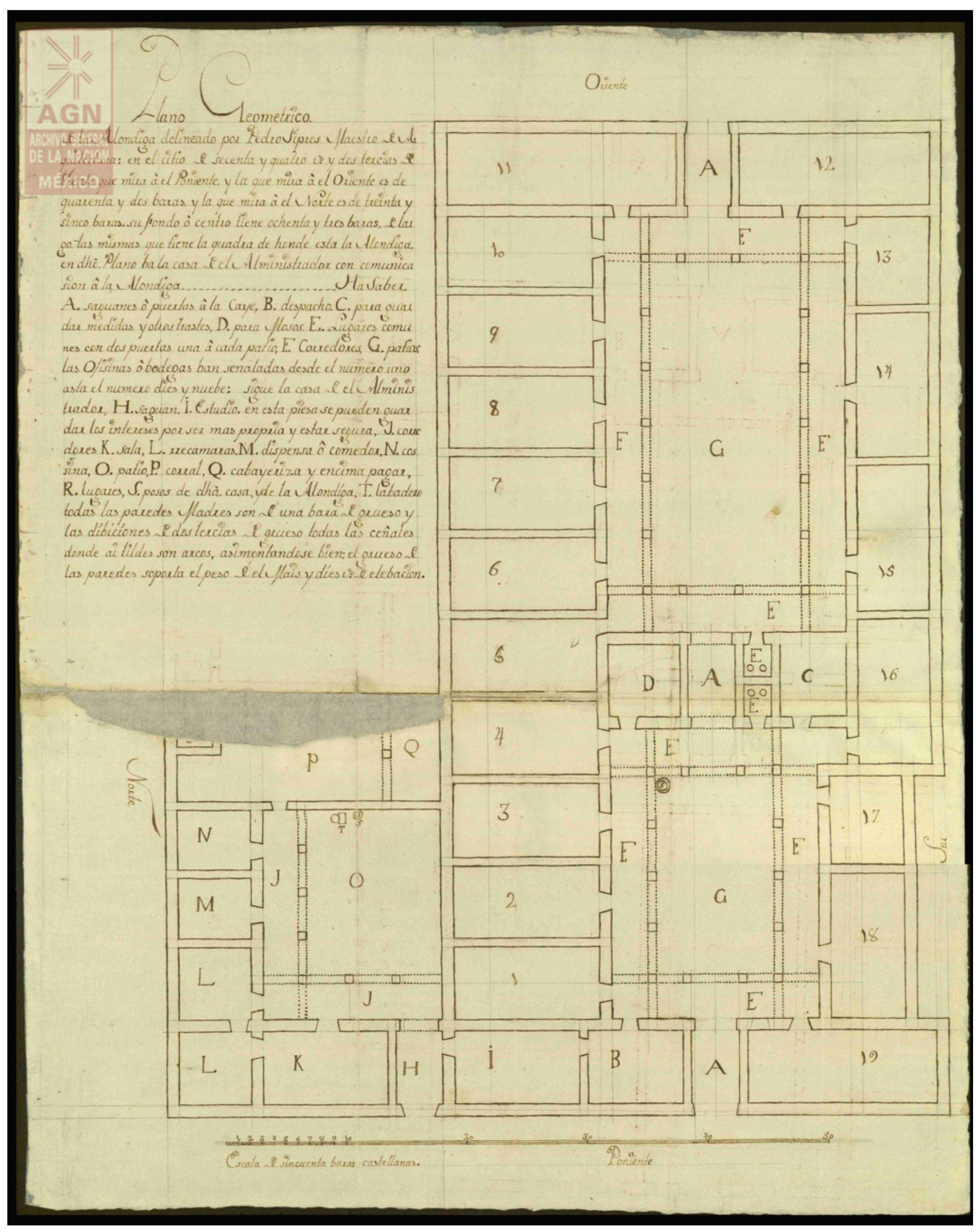
by
Luis Gordo Peláez
Department of Art, Design, and Art History, California State University, Fresno, CA 93740, USA
Arts 2022, 11(2), 42; https://doi.org/10.3390/arts11020042
Submission received: 27 December 2021 / Revised: 27 February 2022 / Accepted: 2 March 2022 / Published: 7 March 2022
(This article belongs to the Special Issue A 10-Year Journey of Arts)

Abstract

:
During the late colonial period, numerous Novohispanic cities embarked on an unprecedented number of projects aimed at reshaping their urban spaces and improving infrastructures, including new facilities for grain storage and supply. The construction of alhóndigas (public granaries), along with other public works and infrastructures, was further propelled by the implementation of Bourbon reforms in Spanish America and the 1780s reorganization of the colonies into intendencias (provinces), as part of the monarchy’s efforts to improve the colonial administration and economy and centralize royal power. The newly appointed royal officials (intendentes) were instrumental in the implementation of these reforms, overseeing tax collection, promoting economic growth and agricultural production, improving mining, and developing a program of public works to embellish and modernize the urban environments and ameliorate the living conditions of their residents in sanitation, public health, water infrastructure, and food supply. This essay explores the projected alhóndigas for two late colonial Mexican cities and how they engaged with contemporary discussions about the efficacy of public works, the circulation of ideals promoted by enlightened reformers on good governance and civic order, issues of artistic and architectural production, and the transmission of a reformist aesthetic agenda from the center to the provinces of New Spain.

1. Introduction: Granaries in Late Colonial Mexico

By the middle eighteenth century, granaries already had a long history in colonial Mexico and throughout the early modern Spanish empire (Gordo Peláez 2010, pp. 432–58). Mexico City’s alhóndiga was originally established in the late sixteenth century, pioneering the first institution of its kind and its ordenanzas (laws) in New Spain. Other alhóndigas followed a few decades later in the cities of San Luis Potosí, Zacatecas, and Guadalajara (Hernández Soubervielle 2013b). The 1681 Recopilación de Leyes de las Indias (a compilation of legislation of the Indies issued by the Spanish Crown) explicitly instructed the colonial administration to follow the model of Mexico City and that “all the main cities and towns of the provinces of the Indies, where it is convenient to found alhóndigas for the supply of the republic and to remedy the inconveniences that result from there being in them speculators [regatones] and resellers of wheat, flour, and other grains, they be founded for the common good” (Recopilación 1681, vol. 2, fol. 109v). As Novohispanic cities grew in population and prosperity during the eighteenth century, alhóndigas and pósitos (the city’s own grain reserve) became vital institutions that served to store and sell grain at controlled prices, diminish or eliminate speculation, counteract shortages, and guarantee the supply during droughts, frosts, epidemics, and other natural and economic setbacks that could affect the growing season and harvest (Florescano 1969, pp. 43–50, 140–79; Van Young 2006, pp. 75–103).1 To this end, following the famine of 1785–1786 in New Spain, enlightened reformer José Pérez Calama advocated for an extensive construction of public granaries in the main cities of the diocese of Michoacán, which included densely populated cities such as Valladolid (today’s Morelia), Guanajuato, and San Luis Potosí (Florescano 1969). The ideas of this canon of Valladolid cathedral, future bishop of Quito, circulated in an unsigned letter, published in 1786 in the Gazeta de México, in which he referred to the writings of Prussian statesman Jacob Friedrich Bielfeld.2 In a volume, published in Spanish in 1767, Bielfeld had previously discussed preventive measures against hunger and food scarcity, recommending the introduction of grains and the fabric of public granaries and warehouses in proportion to the size and population of a city (Bielfeld 1767, vol. I, p. 256).3 Likewise, a 1786 Real Ordenanza instructed the intendentes to inspect the state of the alhóndigas in their provinces, reiterating how cities and towns not only benefitted from these buildings that supplied grain and flour to the population but also to prevent the speculators’ malice. Therefore, and replicating the royal legislation compiled in 1681, intendentes were ordered “to establish them in the large cities if they are convenient for the utility of the common [people]” and prepare the ordenanzas for their administration (Real Ordenanza 1786, pp. 74–85; Rees Jones 1979; Pietschmann 1996).
In the late 1700s and early 1800s, climate-related calamities that upended lives and had a direct impact on agricultural production and other industries continued to be responded to with devotional practices. Processions, novenas, and rogation days abounded in the Novohispanic cities. However, cabildos and officials of the colonial administration increasingly discussed more efficient infrastructure and building projects (alhóndigas, bridges, roads, drainage projects, aqueducts, water reservoirs) to mitigate the consequences of extreme weather events while benefiting the common good and propelling economic growth. That public works gradually prioritized the discourse of the intellectual elite can also be ascertained with the case of a monumental bridge erected over La Laja River near Celaya, a city 65 miles south of Guanajuato. The periodical Diario de México publicized the new construction in a column of 27 February 1807 that celebrated the city’s munificence and the viceroy’s support (then José de Iturrigaray) for an infrastructure pursuing the common good, concluding that “a bridge, a road, and other such works are preferable to many pious ones due to its general benefit to both souls and bodies” (Diario de México 1807, pp. 223–24).
As historian Gabriel Paquette has demonstrated, the notion of public good and happiness permeated the ideological discourse of the late Bourbon Spanish empire in relation to the role of the state. These ideas, inspired by Ludovico Antonio Muratori’s writings, also circulated in New Spain and are key to understanding the reformist agenda the officials of the colonial administration and local governments aimed to implement (Paquette 2008, pp. 56–58). In his treatise La Pública felicidad. Objeto de los buenos príncipes (On Public Happiness. An Object of Good Princes), this Italian historian and reformer argued that more durable and capable granaries, improved water infrastructure, and superior hospitals not only benefited the public welfare, they also preserved public tranquility and contributed to demographic growth, economic prosperity, and, ultimately, the state’s revenues (Muratori 1790, pp. 209–21).4
An active agenda of public works also aimed at tackling what enlightened reformers deemed one of the ills against the social peace and progress of the nation. Campaigns against vagrancy, policies to occupy the idle population, and initiatives, such as Mexico City’s Poor House, to eradicate mendicity and to reassert racial control took center stage in late Bourbon New Spain (Arrom 2001). In his bando (edict) of 10 April 1786, viceroy Bernardo de Gálvez called for an infrastructure campaign that would recruit unemployed “robust and young men, who only beg for alms for not finding where to work or not having the means with which to look for support”.5 His measure followed the devastating effects of the mentioned famine in New Spain and a sharp rise of the poor and unemployed population in Mexico City. In a similar vein, viceroy Revillagigedo stated in 1790 the benefits of undertaking a program of public works for it would “distract the spirits and keep them occupied, giving with which to support the needy, who are the most inclined to revolution” (Calvo 2010, p. 99). Although initially intended for the viceregal capital and its surroundings, Gálvez’s program of public works, reinforced by the royal instructions for intendentes issued in 1786, would resonate in the Novohispanic provinces (Florescano 1969, pp. 157–59).6 The urgent need to repair and build granaries aligned with these policies intended to benefit the common good and preserve social order. Indeed, in March 1790, almost a year after his arrival as new intendente of Zacatecas, Felipe Cleere lamented the decadence of the province’s capital due to the decline of its mining industry, the reduction of its commerce, and the dearth and sterility of its stony surrounding land. In the eyes of the intendente, this had adversely affected the social order in Zacatecas as “the lack of operations and the excess of time endows its inhabitants with a painful indolence, stemming from idleness, the primary cause of all vices, gambling, drunkenness, and consequent disorders that, in commoners, promote chimeras, robberies, and homicides, with no other brake than prison” (AGN, Obras Públicas, vol. 31, exp. 9, fol. 102v). As a solution, in a report addressed to viceroy Revillagigedo in Mexico City, Cleere proposed three initiatives, for which financing he was requesting the approval of new excise taxes: to build a new and spacious granary, to repair and enlarge the damaged and inadequate jail and casas reales (city hall), and to adapt the old Hospital of San Juan de Dios as a needed casa de recogidas (women’s shelter) and hospice.
Local urban initiatives and regulations (new or updated ordenanzas approved in several Mexican cities) also attempted a rapid transformation of the urban space and how its occupants would use it. New and more capable alhóndigas could also contribute to this momentous modernization of a colonial Mexican city, and not just because they were equipped with an ample, solid, and better-organized storage space. As one of the propios of the cities (municipal income), alhóndigas also taxed the private grain entries and provided funds to finance other public works and infrastructure, such as street repairs, paving, and sanitation. For instance, in Guadalajara, the city collected half of a real for each fanega (bushel) of maize, which contributed 3000 to 4000 pesos to the municipal revenues by the 1790s (Chávez Orozco 1956, p. 12).
Buildings serving as alhóndigas had been increasingly allocated by local governments since the late seventeenth century, often combined with other facilities for municipally controlled food services, such as the butcher shop. Yet these early granaries were modest constructions, often repurposed buildings made of adobe walls that were simply adapted to their new storage function. In 1753, the cabildo (city council) of Antequera (Oaxaca) petitioned the viceroy for the construction of a new and much-needed granary in the central Plaza de San Juan de Dios, aiming to replace a deteriorated house the city was then renting for this purpose. Upon visiting the old alhóndiga and inspecting its interior and exterior, Bonifacio Mexía, one of the city’s clerks, confirmed its ruinous condition, while advocating for the new building:
“I have seen that it [the old granary] is extremely deteriorated, both in its ceilings and in its walls, because some are collapsing and others, like those of its patio, completely fallen to the floors, momentarily threatening an irreparable ruin, thus making it uninhabitable.”
(AGN, Alhóndigas, vol. 1, exp. 4, fol. 41)
By the late eighteenth century, most of the existing granaries were compromised or did not serve the original purpose. As happened in Oaxaca, minutes from cabildo meetings and recorded observations of residents and architects inspecting the old granaries are recurrent and very illustrative of the problems these built fabrics and the late colonial cities faced. Lack of space and humidity were challenges that repeatedly undermined the viability of the granaries. Securing a solid, ample, and dry deposit for the grain was paramount to guarantee the city’s supply and the health conditions of its inhabitants.
It is in this context that I focus mostly on two case studies from Guadalajara and El Bajío, a region of west-central Mexico that in the eighteenth century comprised parts of the modern states of Jalisco, Guanajuato, Querétaro, and San Luis Potosí (Figure 1). These were two of the most prosperous agricultural regions in colonial Mexico, turned also into economic hubs closely linked to the Northern Novohispanic mining districts, which contributed to the development of some large and densely populated urban centers such as Guadalajara, Querétaro, Guanajuato, Celaya, and San Luis Potosí (Figure 2). New or renovated alhóndigas were also projected in other large administrative centers or provincial capitals of late Bourbon New Spain, in port cities, and in those Reales de Minas (mining districts) that were at the center of the booming farming and mining industry. All these architectural projects, some calling for monumental constructions with a language of geometrical regularity and classicizing forms (as we will see shortly), corroborate the increasing attention alhóndigas were receiving from cabildos and colonial institutions, particularly at the turn of the century, when these a priori insipid storage buildings made it more frequently to the drawing table of local alarifes (master builders) and Mexico City’s academicians. This essay examines the projected alhóndigas of Guadalajara and Querétaro through the analysis of a variety of archival records and published sources that reveal the negotiated nature of public works in late colonial Mexico, situating this architectural process within the regulatory apparatus of the imperial state, the local power structures, and the ideological foundations underlying the Bourbon reforms. It also sheds light on the understudied subject, particularly in anglophone scholarship, of public works and civic architecture in late colonial Mexico, the architectural practice in the Novohispanic provinces, and the control the state and its institutions aimed to exercise over the local finances and major building projects beyond the viceregal capital.

2. Alarife Pedro José Ciprés and the Plans for Guadalajara’s Alhóndiga

Guadalajara was capital of the vast province of Nueva Galicia, in the western part of the country, and seat of one of its oldest dioceses. By the late eighteenth century, Guadalajara’s hinterland was also one of the most prosperous farming regions in Bourbon New Spain, and the province’s capital served as a major mercantile center (Van Young 2006, pp. 11–27). Discussions at the city level for the fabric of a new granary intensified in the last decade of the 1700s, during the tenure of the active intendente Jacobo Ugarte y Loyola (1791–1798). Modeled after the initiatives of viceroy Revillagigedo for Mexico City, Ugarte advocated for a number of urban projects and infrastructures that attended to the needs of Guadalajara in terms of street paving and sanitation, a reliable water supply, a regulation of the market spaces, and the relocation and construction of cemeteries and hospitals away from the city center (Gálvez Ruiz 1993, pp. 295–367; Castañeda 2002, pp. 67–80). In a similar vein, in late 1796, the cabildo of Guadalajara reported to the intendente that the grain held in the public granary was insufficient to satisfy the demand of an increasing population, and its preservation and quality were also compromised by the miserable conditions of this building (Chávez Orozco 1956, pp. 3–5).7 Since the mid-eighteenth century, Guadalajara’s population had tripled to some 28,000 by 1793, and it would continue to grow exponentially in the following two decades (Van Young 2006, pp. 29–31). In addition, the mentioned famine in New Spain, prompted by a combination of previous short harvests and a crop failure in 1785, exacerbated the situation and further propelled building initiatives at the city level, either projected earlier or newly planned, to improve the food supply and storage.
Serious concerns about the soundness of Guadalajara’s granary arose in the last years, but in 1796, the cabildo and the intendente seemed determined to move forward with a solution. One initial proposal called to repair the existing alhóndiga, and a preliminary budget for the most immediate works was submitted by local carpenter Pedro Ramos (Chávez Orozco 1956, pp. 6–7). Yet, the unfit structure led some members of the government and the city elite to question the wisdom of making partial repairs to an already faulty construction. Moreover, the investment could be insufficient in the long term, as it would not resolve the problem of storage capacity. As an alternative, discussions pointed to a different solution, to acquire the old hospital of the Bethlehemite order (the Belén Hospital) and transform it into a new multipurpose building that would encompass, first, a larger granary, with solid and numerous storerooms, free from the humidity endured in the old building; second, the barracks for the provincial militia, then housed in a rented inn; and third, new facilities for the city’s butcher shop. Furthermore, the new buildings would inherit the concession of two pajas of water (measurement unit used for water allocations) granted to the old hospital and the connection to the city’s sewer that carried the waste away to the river (Chávez Orozco 1956, pp. 12–13).
The ambitious project required a substantial investment and careful planning. To that end, a special committee was created with José Monasterio, Guadalajara’s procurador general (the city’s attorney representing the interests of the public), and a couple of the city councilors, Alfonso Sánchez Leñero and Domingo Pérez. They were instructed to gather information from ten city residents (some former city councilors, others members of the Guadalajara elite) responding to a detailed survey on the condition of the old granary and the proposed new location and construction (Chávez Orozco 1956, pp. 14–40). Their testimonies shed light on the utility and convenience that were expected from granaries and other public works in the late eighteenth century, contributing to the common good while also implementing urban policies of order, sanitation, and embellishment.
Guadalajara’s old alhóndiga was located in the neighborhood of Santo Domingo, to the northeast of the city center, in a sloping terrain next to the river, therefore, away from the usual entrance of the maize into the city from the south. Mule drivers and their carts needed to traverse many principal streets in the city center, which complicated their work, caused inconvenience to residents and pedestrians, and harmed the paving. The submitted testimonies confirmed the deplorable state of this alhóndiga, whose fabric was affected by widespread humidity caused by its location near the water and the fact that the interior floors were below the street level. Furthermore, the walls were cracked and infested by weevils and other bugs that spoiled the stored grain on a regular basis. One of the witnesses, Manuel de Llera, denounced that, in his almost fifty years living in Guadalajara, the issue of maize rotting in the public granary due to these problems was recurrent and a major concern for the health conditions of the inhabitants, particularly those who heavily depended on this supply (Chávez Orozco 1956, pp. 34–35). Indeed, in some years, the grain had to be sold at low prices to feed the pigs or simply discharged. When completely filled, the storerooms, ten of them, could hold up to 18 or 20,000 fanegas of grain, an amount that was deemed very low for what the city needed. Given the demographic boom of late eighteenth-century Guadalajara, it was argued that at least triple of that amount was required to guarantee an equitable price and prevent the shortage and speculation. To add to it, when the storerooms were full, which occurred often due to their small size and low ceilings, the maize was left in the alhóndiga’s open corridors and patio, risking getting soaked by the rain or stolen.
The proposed location for the new granary was ideal, as several witnesses confirmed. The Belén Hospital, the site proposed for the new facilities, was only three blocks away from the Plaza Mayor, as can be discerned in the 1745-map of Guadalajara drawn by Juan Francisco de Espino.8 This central location would facilitate the daily access of the population to this essential marketplace. Indeed, the proposal for a new granary had been brought to the attention of Guadalajara cabildo four years earlier because of the need for a new location, as confirmed by one of the witnesses interviewed in 1797. José Eugenio Moreno de Tejada, former alcalde ordinario (judicial officer and member of the city council) and síndico procurador general (public attorney), declared that plans for a relocation of the granary facilities to the house of the former bishop Diego Rodríguez de Rivas were discussed in 1792–1793, and Pedro José Ciprés, the city’s maestro mayor de obras (chief architect), drew the design of an alhóndiga (Figure 3) in the repurposed building (Chávez Orozco 1956, p. 32).9 Yet, ultimately, this 1793 project was abandoned, among other reasons, for being too distant from the city center and requiring costly repairs.
A similar concern with the ideal situation of these public works was shared by other cities who also took part in this building campaign in late Bourbon New Spain. In 1771, when the construction of a new alhóndiga was arranged in the city of San Luis Potosí, the new fabric was located two blocks away from the city center, facing one of the squares (Figure 4) that served as the main marketplace for the sale of grain and other food supplies (Hernández Soubervielle 2013b).10 Along with emphasizing the utility and convenience of the building, this central location allowed the city to project an image of imperial reform, order, and authority for the audiences in the market square.11 This message was particularly relevant in San Luis Potosí, following a decade of mobilizations and conflict in the Bajío region that led to the destruction of the city’s casas reales in 1767 (Hernández Soubervielle 2013a).
The idea of congregating in one block several public offices, as planned in Guadalajara, was consistent with what some cabildos were carrying out in other cities. Indeed, the design of granaries in eighteenth-century New Spain went hand in hand with the fabric of other public works, particularly new offices for the government, jails, royal treasuries, and military barracks. The government buildings projected or renovated at the time, as seen in a 1800 plan (Figure 5) for the repairs of Chihuahua’s city hall and alhóndiga, often gathered or continued to gather in one building or in adjacent constructions the varied administrative units and services that pertained to or were regulated by the city, such as the jail, the granary, and the butcher shop.12 This was also the plan in the city of Valladolid de Michoacán, where earlier, in the 1770s, architect Francisco Martínez Gudiño directed the expansion and renovation of the existing city hall to which a new jail and alhóndiga were attached in a spatial sequence that provided additional room for an expanded bureaucracy and for decent and more comfortable facilities (Vargas Chávez 2013, pp. 312–29).13
As opposed to the old construction, the site for the new Guadalajara alhóndiga was above the street level and occupied an entire city block, therefore reducing the risk of the feared humidity and providing ample space to accommodate the proposed buildings. Although some witnesses disagreed as to what facilities to include in the new location beyond the alhóndiga, all concurred that the site, previously occupied by infirmaries and other spaces for the care of the sick, did not pose any risk for the future stored grain or for the health of its consumers; a concern that had been raised in the initial deliberations by Diego Miguel de Moya y Colón, prosecutor of the Royal Audiencia of Guadalajara. With the committee’s favorable report, the cabildo requested maestro mayor Ciprés to prepare a detailed budget and plan of the new granary intended for the site of the old hospital. Ciprés crafted two plans that included space and offices for the three facilities: the new alhóndiga, the military barracks, and the butcher shop. These 1797 plans, identified in the documentation as “Plano Geométrico” (Geometrical Plan) (Figure 6) and “Plano 2” (Second Plan) (Figure 7), were accompanied by two detailed accounts containing some relevant information about the projected building (Chávez Orozco 1956, pp. 42–47).14
The old Belén Hospital occupied a city block of about 82 by 84 varas (a vara equals 0.83 m) or about 68 by 70 m.15 For some context, the façade of Mexico City Cathedral is about 190 m long and 54 m wide (Toussaint 1948, p. 77). Therefore, the new site for Guadalajara’s relocated granary was a sizable space, needed for the multiple functions intended for it, and considerably larger than the building then used to store wheat and maize.16 In the first 1797 project, the Plano Geométrico, Ciprés aimed at only reusing the perimeter walls of the parcel, as well as some building materials, woods, and ironwork. He proposed to create two entrances and their zaguanes (hallways) at the north and south sides of the building, an office and residence for the granary administrator, auxiliary spaces (including kitchen, pantry, latrines, a weighing room), and 23 storerooms, all located on one floor and with 18 of them of a similar size of 15 by 6 varas each.17 The remaining five storerooms were larger, adapted to the interior arrangement of spaces, but keeping as a constant in the layout the same geometry and uniformity that proclaims the description of the plan. The storerooms were to be distributed around two consecutive central courtyards, holding up to 72,000 fanegas, almost four times the capacity of the old granary.18 This project was estimated at 16,000 pesos, plus 20,000 pesos for purchasing the new site.19 At half the cost (8700 pesos for the repairs), the second 1797 plan for Guadalajara’s new alhóndiga called for a more economical modification of the existing structures that would consequently be faster to implement. It would preserve most of the previous construction, with spaces to be altered, building up or tearing down some walls, opening new doors, raising the floors, replacing some brickwork, and so on. As the plan elucidates, this solution did not yield the uniform and symmetrical layout that the architect devised in the other drawing. Furthermore, this second option reduced the number of storerooms distributed around two unequal courtyards that, nevertheless, underscored the intended functionality tailoring the interior spaces to its three specific uses.
These designs also provide some insights into the draftsmanship of this local architect whose career was partly eclipsed after 1805 with the arrival from Mexico City of academician José María Gutiérrez (Camacho Cárdenas 2012).20 In both plans, as he also described in his written account, Ciprés utilized three different colors to differentiate each facility, with dark blue or purple for the barracks, orange for the butcher shop, and red for the alhóndiga. In his “Plan Geométrico”, he demonstrates some familiarity with the reformist educational agenda of the Mexican Academy and with the refined drawing practices and skills advocated by contemporary military engineers, in regards to the importance of applying geometry and arithmetic to carefully drafted plans, where color shades and a precise scale were to be implemented to facilitate uniformity in the production and reading of these documents.21
It is worth noting that this regularity and grid-like layout that architect Ciprés designed, something that was also contemporarily implemented in other types of civic architecture elsewhere in colonial Latin America, was part of a strategy that denoted imperial power, rationalism, and a reformist social and economic agenda (Niell 2015). In Guadalajara’s new granary, Ciprés’ geometrical design visualized the efficiency expected from this new granary that would serve to better organize the grain entries and storage, with mule drivers and their carts gaining access through one entryway, proceeding through the central patios, unloading the maize, and exiting through the opposite doorway. The uniformity of the storerooms and this spatial order, with the precise alignment of the two central doorways and the pair of courtyards, represents a departure from what was experienced and planned in some earlier granaries where the layout betrayed a lack of those principles.22 For instance, as seen in a 1753 plan of the city hall, jail, and alhóndiga of Bolaños (Figure 8), a smaller mining town to the north of Guadalajara, the four arches of its main façade facing the plaza mayor belied any continuation of spatial symmetry in its interior.23
Ciprés’ budgets and designs were submitted in January 1798. After reviewing the documentation and designs, Guadalajara’s procurador general Manuel González de Vallejo prioritized the second plan arguing, among other things, that its cost and time of construction were significantly less while its benefits to the city and the resulting storage capacity were similar to the first proposal. Likewise, the precarious condition of the old alhóndiga urged immediate action. In addition, as some witnesses pointed out, González de Vallejo sided with those who opposed transferring the butcher to the new location. Instead, he recommended using that space to enlarge the barracks. Curiously, he added that if the barracks were to be relocated to a larger site in the future, the building could be converted into a theatre, which the city lacked, instead of using, as was happening, “the filthy plaza de Gallos [the cockfighting arena] or another less indecent place without the appropriate proportions for the convenience, tidiness, decency, and distinction of the attendants” (Chávez Orozco 1956, pp. 50–54). Procurador González de Vallejo urged the cabildo to act promptly given the precarious conditions of the old alhóndiga and to either use funds from the city’s Propios or those owned by the pósito, with the approval of the intendente and the Junta Superior de la Real Hacienda (chief finance committee in Mexico City). The cabildo joined efforts with the procurador and supported choosing Cipres’ second design for the alhóndiga. Clearly, utility and celerity, and not uniformity or geometry, guided the cabildo’s decision.
Nothing materialized then, as once again in August 1804, Ciprés was called by the new intendente, José Fernando Abascal y Souza (1800–1804), to inspect and measure the old Belén Hospital and prepare a new budget for its transformation into an alhóndiga. As Ciprés stated at the beginning of his report, seven years had passed since his last inspection, plans, and budget. The building was now more deteriorated in its walls and ceilings, to the point that the wood from the latter could only serve for scaffolding. The repairs, Ciprés estimated, could be concluded in 324 days, but at a cost of 25,553 pesos, significantly higher due to the rising price of the materials (Chávez Orozco 1956, pp. 61–63). Three years later, in 1807, the project remained on the drawing board for several reasons. As the province’s intendente Roque Abarca (1805–1811) confirmed, Ciprés, who had been appointed to direct the works, was temporarily away from Guadalajara and unable to take on this role “until the very important work of the bridge of the river of the town of San Juan [140 km northeast of Guadalajara] is completed, of which he is commissioned by His Excellency the Viceroy” (AGN, Obras Públicas, vol. 12, exp. 21, fol. 349r). Furthermore, the need for guarantors for the commissioners elected to oversee the construction and handle the finances prevented the delivery of funds from the city’s Propios to initiate the works.
Architect Ciprés remained very active in late colonial Guadalajara and its region, where his name is documented in a variety of architectural projects, some of them in collaboration with the mentioned academician José Gutiérrez.24 Yet, for the most part, his work remains understudied.25 Of indigenous or mixed-race descent (church records at different times identify him as indio, coyote, and mestizo), Ciprés was born in 1761 in San Andrés, one of the outlying indigenous villages bordering the city of Guadalajara (Gutiérrez Lorenzo 2007, p. 70).26 He belonged to a generation of guild-trained alarifes and maestros mayores working as official architects of a city in the provinces of late Bourbon New Spain at a time when their designs and buildings were increasingly scrutinized from the viceregal capital.27 The Royal Academy of San Carlos, entrusted with the evaluation of architectural projects since its 1783 foundation, aimed at expanding and tightening its grip over all artistic projects in New Spain, shaping learning habits and taste, and reforming production and working practices (Báez Macías 1974; Brown 1976; Fuentes Rojas 2002).28 Likewise, the 1786 Real Ordenanza also instructed intendentes to monitor any major construction projects in their provinces, particularly churches, public works, and civic architecture. Prior to initiating any construction, the cost of these buildings and their designs, “drawings of their plans, elevations, and cross sections” (dibuxos de sus planes, alzados, y cortes), had to be submitted to Mexico City to be examined by the Junta Superior de Hacienda and by engineers and architects designated by this committee. In reviewing the plans, these royal instructions reinforced the contemporary ideals on architectural design fostered by academicians as they stressed that, if needed, the projected buildings were to be rectified taking into account “a greater firmness and endurance of the work, as well as the beauty, good distribution and other parts recommended by the authority” (Real Ordenanza 1786, pp. 80–81). In other words, in this legislation, colonial administrators and architects were compelled to attend to what clearly underlines the founding principles of Vitruvian architecture. The values of strength, commodity, and beauty, key to this ancient Roman architect for a well-designed building, surface also in the comments of the architects and academicians that participated (either designing or evaluating constructions) in this building campaign of granaries in late Bourbon Mexico. Mexico City’s architect José del Mazo, who was directly involved in the design of the Guanajuato alhóndiga in the late 1790s, emphasized these ideals in his revision and drawings for this granary (AHUG, Alhóndiga (2a), Caja 3, 1793–1809, fols. 39r–41r).
Yet, the training and certification of architects (which had been traditionally controlled by the cabildos and the local guilds) and the practice and definition of their profession remained a controversial issue in the late colonial period.29 Years after the opening of the Academy, Mexico City’s intellectual elite continued to question, particularly, the results of those working in the Novohispanic provinces and to voice their opposition to any artistic and architectural endeavor not previously submitted to academic approval and supervision. In a letter sent to viceroy José de Iturrigaray on 6 February 1805, the professors of the Mexican Academy reiterated the need to propagate “the good taste in the arts and avoid the abuse of them done especially in the cities and towns away from the capital, where painting, sculpture and architectural works are freely carried by incompetent people, and this freedom has already caused the saddest consequences” (Báez Macías 1972, p. 15).
Although their careers unfolded in the margins of the late colonial academic setting, Ciprés and other local alarifes and master masons were paramount for the development of a public works and infrastructure agenda in Bourbon New Spain, often traveling to and attending to building projects in several regional centers.

3. Magnificent Granaries: Alhóndigas in Querétaro and the Bajío Region

In a thriving urban center of the Bajío region, the cabildo of the city of Santiago de Querétaro was facing similar problems in regards to the inadequacy of the city’s facilities for grain storage. In the 1790s, the testimonies of the local elite and officials working on or familiar with the use and fabric of the public granary raised alarms. Querétaro was experiencing a population boom, and the insufficient supply of food and water was a serious concern. One of those residents addressing the cabildo was Antonio Septién, captain of the provincial militia and member of one of the most prestigious families in the region. His testimony regarding the deplorable conditions of the old granary was the most poignant, enumerating the deficiencies of the unfit construction, from the badly distributed space to the small size of its storerooms to the ruinous condition of its damaged adobe walls and rooftops to the pervasive humidity throughout the building, which was not only detrimental to the stored grain but also potentially dangerous to those unloading it or working there. Furthermore, Septién provided information on the interior spatial arrangement of the old alhóndiga. There were two patios; the first one was larger and gave access to 14 storerooms, while the second one was smaller and housed 13 storerooms also of reduced size. The largest rooms were located in the corners of both patios, being about 10 × 5 varas in size. It was key, Septién concluded, to expand the granary but also to give it a solid and more efficient spatial arrangement, thus anticipating a factor that was paramount in the future architectural projects (AGN, Obras Públicas, vol. 25, exp. 6, fols. 211r–229v).
The initial approach, as happened in other cities, was to repair the existing construction. Local architect and surveyor José Mariano Oriñuela, whose prolific career also requires further attention in English scholarship, was first entrusted with the design of an expanded and repaired granary, for which the city planned to acquire an adjacent property.30 In his report and plan (Figure 9) of late 1795, Oriñuela clearly demarcated in red the new addition as well as his proposal to better arrange and navigate the interior spaces of the alhóndiga.31 Let us not forget that utility and convenience were paramount for these structures, as we have previously noted. The two original patios separated the deposits of maize and flour. Oriñuela planned 13 additional storerooms for the annex and suggested a profitable distribution and use of the space by accommodating larger and smaller storerooms, with the latter adapted to smaller grain deposits of up to 500 fanegas. Likewise, he proposed to leave eight rooms that faced the streets of Alhóndiga and San Antonio available for rent, which would provide extra income for the city. The total cost of the project, including repairs to the existing alhóndiga and the purchase and adaptation of the new property, amounted to 6,764 pesos (AGN, Obras Públicas, vol. 25, exp. 6, fols. 230r–234r). The file was reviewed in Mexico City, as Querétaro requested the use of the city’s Propios and imposing extra taxes to finance the works. The proposal was approved by the Junta Superior de Propios in 1797, at a time when Guadalajara and other nearby cities, such as Guanajuato, were also petitioning and moving forward with their own granary projects (AGN, Obras Públicas, vol. 25, exp. 8, fols. 304r–317r).
The years of 1790–1810 were particularly active in the Novohispanic cities for the implementation and design of these public works. For instance, along with the examples seen so far, in 1800, Manuel Tolsá was commissioned by the intendente of Durango, the capital of Nueva Vizcaya, to prepare some designs for a new multifunctional building that would house, among others, the meeting chambers of the local government, the residence of this Northern province’s governor, the alhóndiga, and the city’s Casa del Ensaye (royal assay establishment) (AGN, Obras Públicas, vol. 25, exp. 10, fols. 333r–359v; AGN, Obras Públicas, vol. 16, exp. 1, fols. 1r–9v). In 1804 and 1809, two other mining cities from Northern New Spain, Zacatecas and Real de Catorce, submitted their respective plans of granaries for their evaluation at the San Carlos Academy in Mexico City (AGN, Indiferente Virreinal, Caja 3374, Expediente 042 Alhóndigas, fols. 5r and 7r).32 In the same year of 1804, French architect Juan Bautista Crouset penned the plan (Figure 10) of a new alhóndiga for the mining community of Valle de Matehuala, 194 km north of San Luis Potosí.33 After his early years of training in Italy and Spain, Crouset resettled in the Americas and had a long and successful career from his work in Mexico City to his appointment as academician and chief architect of the Northern Novohispanic city of Monterey in 1792 (Tovar Esquivel and Garza Luna 2006).
Despite its initial approval and modest budget, the 1797 project to renovate the old granary in Querétaro came to a halt. Although evidence has yet to surface, it is likely that the local government had difficulties securing the needed funds at a time when it was also attending to other more costly repairs in the city’s water system. Indeed, three years later the cabildo of Querétaro petitioned the viceregal authorities for the use of funds collected in the city from excise taxes on maize in order to attend to the long-overdue repairs and expansion of the granary (AGN, Obras Públicas, vol. 25, exp. 8, fols. 304r–317r). In any case, by 1803, Querétaro’s cabildo no longer aimed at fixing the old granary. Years of delay and inadequate repairs had left the construction on the verge of collapsing.
A special committee was arranged in order to work with Mexico City architect and academician Francisco Ortiz de Castro, who was then living in Querétaro and attending to other building projects, including the Convent of the Teresitas. Ortiz was asked to prepare a budget and plans for a new alhóndiga, with the cabildo explicitly emphasizing that “nothing could remain from the old [one]” (no ha de quedar cosa alguna de la vieja) (AGN, Obras Públicas, vol. 23, exp. 5, fol. 164r). The building needed to have two floors, with space for storerooms of several sizes (500, 1000, and 2000 fanegas), residence of the granary’s administrator, and two doorways to facilitate the entrance and exit of the building. In addition, the rooms on the ground floor needed to be vaulted, and a clear separation between spaces for maize and wheat flour was instructed. After some delays on the part of the architect (that the cabildo strongly protested), in April 1804, Ortiz submitted the budget and three drawings for the new fabric that would also accommodate the butcher shop and extra rental spaces on the ground floor to yield additional income for the city (AGN, Obras Públicas, vol. 23, exp. 5, fols. 164r–170r).
Francisco Ortiz remains an understudied figure of the architectural and academic scene in late colonial Mexico, as opposed to his more known brother and fellow architect, José Damián Ortiz de Castro (González Franco et al. 1994, vol. I, p. 290; Fuentes Rojas 2002, pp. 272–77). In the early 1800s, Francisco remained active both in Mexico City and the Bajío region.34 A year after completing the plans for Querétaro’s granary, Ortiz is also documented in Guanajuato overseeing the ongoing construction of another alhóndiga, along with local architect Juan de Dios Trinidad Pérez (AHUG, Alhóndiga (2a), Caja 3, 1805-08, fols. 3v–11v). Temporarily relocated to this latter city, 150 km northwest of Querétaro, in late 1805, Ortiz was evaluating what had been constructed in the last seven years and preparing a report of what remained to be done in collaboration with Pérez (Arenas Sánchez 1969; Gordo Peláez 2013).
The account and drawings presented by Ortiz in Querétaro shed light on his academic architectural training and also speak to the classicizing stylistic preferences that dominated the building scene in late Bourbon Mexico City and were spreading to the Novohispanic provinces.35 They also reveal the ambitious and elegant project Ortiz envisioned for a construction to be located steps away from the Plaza de San Francisco, one of the two main squares in the city center (Figure 11 and Figure 12). For the main staircase of the new alhóndiga, Ortiz projected one “de tres tiros”, which is a design that resonates well with imperial order and palatial architecture (AGN, Obras Públicas, vol. 23, exp. 5, fol. 183r). With a symmetrical design, this staircase model consists of three parallel flights in which the central one leads up from the first floor to a main landing, and the remaining two side flights connect this middle space with the second floor. The main staircase at the sixteenth-century Royal Monastery of San Lorenzo de El Escorial (Figure 13), northwest of Madrid, is usually credited with the introduction of this model that later was replicated in eighteenth-century examples of palace architecture, including the Royal Palace in Madrid and the Royal Palace of Caserta in Naples, both Bourbon constructions (Wilkinson 1975). Ortiz did not visit those sites, but he was certainly familiar with their design, as he was also acquainted with a number of treatises on architecture. Furthermore, among those who were trained in the Mexican Academy (and Ortiz was student of the first director of architecture, Antonio González Velázquez), the design of a palace was a frequent exercise and one that was also used by some students as a final project to obtain the title of academician of merit. This was the case of the cited architect, José María Gutiérrez, who in 1794 (therefore, prior to his departure to Guadalajara) presented three plans, two cross sections, and one elevation of a palace to achieve this recognition. Some designs by other Academy students from the early 1800s also include sections of the monumental staircase in the Caserta Palace proving that these models were customary in the instruction of the Mexican Academy.36 It is worth remembering that Ortiz’s design in Querétaro was not for a palace but for a granary.
The new building had to accommodate the existing site with an L shape while providing abundant space for storage on two floors. Symmetry and balance in the arrangement of the space and distribution of the architectural masses seem to permeate the project (Figure 14 and Figure 15). No doubt, Ortiz would have preferred to design a building, like those ideally projected in the classes of the Academy, without the constraints of the existing urban parcel. Yet, the proposed masonry building was a far cry from the old adobe construction still in use. The design also addressed other problems that affected the previous building. For instance, the acequia or water canal that ran next to the walls of the old storerooms causing humidity and damaging the grain was partly redirected away from the deposits of maize and wheat flour in the new project. A similar situation was experienced with the design of the new alhóndiga in San Luis Potosí, proving that access to drinking water was paramount for the sanitation of these facilities and the animals they harbored (Hernández Soubervielle 2013b, pp. 179–80). Yet, it required a well-studied pipping to prevent structural damages to the building and to the grain it stored.37
With independent access from the main façade, Querétaro’s new granary was also to incorporate a shop and other rental spaces, including two houses, on the ground and upper floors. Upstairs, separated from the ground-floor grain deposits, 15 rooms were to be used for the wheat flour. Columns with their pedestals and classical orders were intended for the main two-story patio. Ortiz annotated the use of Ionic order for the top floor, and, although not mentioned in the document, one presumes that in a logical sequence of orders (and Ortiz was a committed classicist), he had in mind Doric columns for the ground floor. The provided section drawing seems to corroborate this superposed order and the use of a Doric entablature with its triglyphs separating the two-level arcade. Likewise, Ortiz referred to, and his design also corroborates it, the use of rustication on the first floor of the main façade; a form of stonework that also resonated with Vitruvius and Renaissance treatises on architecture (AGN, Obras Públicas, vol. 23, exp. 5, fols. 169v, 183r–184r).
Along with the plans of the building, Ortiz submitted a section of the interior spaces and an elevation of the façade, where he renounced the complex ornamental framing of doors and windows, curvilinear motifs, and undulated rooftops that were featured in earlier buildings. The façade proposed in 1773 for the granary of the mining town of Charcas (Figure 16), in the state of San Luis Potosí, illustrates this contrast (AGN, Obras Públicas, vol. 36, exp. 6, fols. 87–125). Three decades later, these forms, which historians have labeled as baroque style, were the object of criticism. The use of an academy-sanctioned language is apparent in the drawing penned by architect Ortiz (Figure 17), who also sharply expressed his disapproval of those who did not adhere strictly to classical architectural theory. In describing the 17 balconies intended for the façades of the building, Ortiz recommended the use of stone, instead of iron, arguing that the latter was “no of architectural nature, and only used due to a habit introduced in the art, of which there is no example in all the ancient and modern authors, such as Vitruvius, Palladio, Scamozzi, Vignola, and others who have dealt with architecture with the accuracy that is generally missed [today] due to a lack of knowledge” (AGN, Obras Públicas, vol. 23, exp. 5, fol. 169v).
The symmetry and balance of the interior spatial arrangement mirrored the order found in the façade where Ortiz emphasized straight lines, classical and austere features, and a regular and uniform distribution of openings, similar to what was under construction in the alhóndiga of Guanajuato. Indeed, a similar preference for classicizing motifs guides the design of the entryways in both buildings. In Guanajuato’s granary, some of the building’s architectural elements were borrowed from Vitruvius’ Ten Books on Architecture and Vignola’s Rule of the Five Orders of Architecture, two treatises well known to Ortiz, as clearly demonstrated by his previous comments.38 The architectural trifles and other decorative excesses of the Baroque, embodied in Guanajuato by the exuberant Jesuit Church (1747–67) and the Templo San Cayetano de La Valenciana (dedicated in 1788), gave way in the new granary to a rational and simple ornamentation of clear lines, geometric shapes, and classicizing architectural forms, of which Mexico City academicians were staunch proponents.39 The sobriety and solid appearance of Guanajuato’s building continues to impress its visitors even today. Symmetry, regularity, and uniformity are prominently featured in the architectural and decorative elements that conform to both its exterior and interior, for instance, the Doric cornice with triglyphs and metopes that crowns the building (Figure 18), the stone classical portals of the two main façades (Figure 19), or the splendid patio where lintels, balustrades, and columns display a vocabulary borrowed from ancient and Renaissance classical sources.
In Querétaro, Ortiz’s design of the new granary also stressed the utilitarian character of the building, while also embodying the monarchy’s desire to project through public works an image of rationality and order for local audiences. In addition, the fact that these and other contemporary granaries were either designed or evaluated by academicians reveals the increasing presence of the Mexican Academy in the provinces of New Spain, underlining the aim of this institution to reign over the local stylistic tendencies, construction projects, and builders. However, it also speaks to the opportunity that this boom of building projects, particularly public works and infrastructure, offered to those academy-certified architects, such as Gutiérrez in Guadalajara and Crouset in Monterey, who relocated and developed their professional careers elsewhere beyond the viceregal capital.
Like Ciprés with the plans of Guadalajara’s alhóndiga, Ortiz was also concerned with making his designs clear and legible for his audience, including those within the profession who would evaluate his work at the San Carlos Academy, as well as the officials of the colonial administration (not trained in architecture) that would assess the project’s viability and cost in Mexico City. He clearly indicated that the section and elevation drawing of the alhóndiga (Figure 17) corresponded to the line between points A and B (“Corte por la línea A B del Plano”) added to the plan of the ground floor (Figure 14). To further facilitate the visual reading, Ortiz also applied a red color to the section drawing distinguishing the vertical cuts through the interior space of the alhóndiga. In addition, along with a scale inserted in the drawing of the ground floor, each space and room of the new alhóndiga was labeled in these plans using a uniform and clear handwriting that seems to correspond to the Spanish letra bastarda (a form of chancery cursive letter).40
As part of the compiled documentation, in July 1804, Querétaro’s cabildo requested the mentioned local architect Oriñuela to inspect and provide an assessment report on the condition of the existing alhóndiga. He confirmed the structural problems of the old building, with some of the rooms already condemned, and favored the new and more solid construction the cabildo intended to bring to fruition. Otherwise, he concluded, the city would continue to find and repair faults in the walls and ceilings, wasting funds, while the population was left with bad quality grain and exposed to the danger of famine; an opinion that was corroborated by the testimony of seven additional residents (AGN, Obras Públicas, vol. 23, exp. 5, fols. 176v–182r).
As with other architectural projects, and in this case, the city, aimed at imposing new excise taxes on maize to fund the building, the file of Querétaro’s granary was closely examined in Mexico City, where it passed from the fiscal de lo civil (attorney for civil affairs) Ambrosio Zagarzurieta to the Junta Superior de Propios, and from this chief finance committee (in charge of auditing municipal accounts) to the Academy. There, Manuel Tolsá, director of sculpture and author of several memorable architectural projects in the viceregal capital, was asked to evaluate Ortiz’s designs and prepare his own budget for the cost of the building. In an explicit rebuff of Ortiz’s project, the chief finance committee instructed Tolsá to reduce the planned granary to the necessary storerooms and “to remove from its exterior any magnificence and adornment so to result in a manner that is simple and less costly” (AGN, Obras Públicas, vol. 23, exp. 5, fols. 189r–201r). In his report and plans of late 1807, Tolsá agreed with Ortiz on the materials proposed for the construction but reduced the dimensions of the building and consequently its cost, as had been requested. Instead of two floors, Tolsá designed a one-story alhóndiga with four patios and 49 storerooms, which increased the total capacity by eliminating some of the rental spaces. With the “simplicity of the architecture,” as Tolsá expressed it, the cost of his granary was a third cheaper than that designed by Ortiz, which originally amounted to 63,505 pesos (AGN, Obras Públicas, vol. 23, exp. 5, fols. 201v–204r). Tolsá’s reformulated plans, today lost, and the intended taxes to finance its construction were approved. Yet, nothing materialized in the next two years. The city still lacked the funds to initiate the construction, and the events that followed the Querétaro Conspiracy of 1810 canceled indefinitely the project of the new alhóndiga.
It is worth noting that, around the same time, Tolsá was also asked to evaluate the ongoing construction in Guanajuato. However, this latter building was at an advanced stage and closer to its completion. Querétaro’s new alhóndiga only existed on paper as of yet. In his comments on Guanajuato’s granary, Tolsá praised the accuracy and clarity of the plans, validated the work of the architect in charge and the budget co-prepared by Pérez and Ortiz, and justified the large size of the building for the public benefit it would bring to the city. Moreover, Tolsá stressed “that the work was designed with the solidity and simple character that corresponds to the building’s purpose, and therefore I do not find anything luxurious or superfluous” (AHUG, Alhóndiga (2a), Caja 3, 1805-08, n. p.; Arenas Sánchez 1969, pp. 315–19). In regards to Querétaro, there is no reason to believe that Ortiz was planning an overtly sumptuous and disproportioned fabric or that other academicians questioned his practice and experience. On the contrary, his project underlined the need for decent, ordered, salubrious, and functional granaries consistent with the Bourbon monarchs’ aim to promote public works and make the colonies more organized and efficient. Perhaps that imperial staircase was seen as out of place by those who, within the chief finance committee, advocated for simplicity and austerity in this kind of public work. Similar controversy was raised by the construction of Guanajuato’s granary, in this case, at the local level, where the new fabric was censured by some as an excessive expenditure for the city. Indeed, one of the former city councilors expressed his disagreement by describing the monumental granary as a “palace for the maize” (Alamán 1849, vol. 1, p. 412).41
Of different opinion about appropriate spending habits was Bernardo Bonavía, intendente of Nueva Vizcaya, who evaluated the mentioned project of a multifunctional building for the city of Durango, the cost of which was estimated at the considerable amount of 138,636 pesos and that would encompass, among other offices, the city’s alhóndiga. Advocating on behalf of the city and its proposal to finance the works with new taxes, Bonavía confirmed the necessity of the construction due to the deplorable condition of the existing buildings. The city hall, Bonavía declared, was indecent; the jail lacked any security, ventilation, and sufficient space; the Cajas Reales (royal treasury) and the Casa del Ensaye were used as inns; the residence of the intendente was “the worst of those labeled as decent;” and the alhóndiga “is in name only, and the pósito a shack without the proper offices.” In fact, Bonavía was reviving a building project that had been previously proposed in the 1780s by one of his predecessors and first intendente in Nueva Vizcaya, Felipe Díaz de Ortega.42 More importantly, in a lengthy statement, Bonavía stressed the benefit of public buildings in the following terms:
“Public works are always useful, even if there is something of excess in them, they are the true magnificence of the nations, and if there is any favorable luxury, undoubtedly it is this one, the only one capable of uniting simplicity in its demeanor, sobriety, and good habits. I cannot be indifferent in the service to the king, and the public, not just in the province I am heading but even in the last corner of the monarchy. I do not foster what I expect to enjoy, I foster what I consider useful and necessary as I have always done when it goes beyond my limited authority.”
(AGN, Obras Públicas, vol. 25, exp. 10, fols. 333r–359v).43
Bonavía’s comments were consistent with the assessment of contemporary architects and academicians. Spanish mathematician and architect Benito Bails, whose book Elementos de matemática (published in 1783 and reprinted in 1796) was key to the architectural curriculum and study plans implemented in the Mexican Academy, argued that “Public buildings, on being so necessary in a large city that without them it would cease to be comfortable, also contribute greatly to its beauty, both for their grandeur and for the profusion with which the most [of them] are usually adorned” (Bails 1783, p. 808). Furthermore, he strongly advocated for the utility of public granaries, which he described as one of the essential public buildings, and provided some practical recommendations on their construction, mostly oriented to a better preservation of the stored grain.
The attempt to revamp the grain architecture in Bourbon New Spain went hand in hand with the implementation of other civic architectural projects, public works, and urban regulations that aimed to enhance and modernize the late colonial Mexican city. In cities such as Guadalajara, Querétaro, and Guanajuato, which by the late 1700s were experiencing an unprecedented population growth, this became a major concern for their governments and they mirrored contemporary initiatives and reforms enacted at the viceregal capital (Viqueira Albán 1999, pp. 174–82; Glasco 2010). In addition, this grain architecture is key to understanding the built environment of extraction that resulted from the development of the agricultural, mining, and manufacturing industries in late colonial Mexico and to which architectural historians have paid less attention. It also invites a further consideration of other understudied building types that shaped and were shaped by this landscape of extraction, such as constructions for the processing of natural resources, storage, and commercial exchange (tobacco and gunpowder factories, customhouses, etc.) that speak not only to imperial strategies of economic transformation but also to a local context of negotiation and agency. In the end, with some exceptions, many of these projects to build new public granaries did not materialize. The tumultuous decade that followed the 1810 Hidalgo revolt, which ironically ignited in the splendid and recently constructed alhóndiga of Guanajuato, and the devastation brought by the ensuing conflict did not invite further expenditure at the city level on these projects. Furthermore, the practice, that still prevailed in some late colonial Mexican cities, of storing and selling grain in private homes, or in the granaries of privately owned haciendas, often undermined the municipal plans to congregate and regulate this trade in new and more solid alhóndigas (Van Young 2006, pp. 67–71; García 1987).

Funding

This research received no external funding.

Institutional Review Board Statement

Not applicable.

Informed Consent Statement

Not applicable.

Data Availability Statement

Not applicable.

Acknowledgments

I would like to thank the editor-in-chief Michelle Facos, the Arts Editorial Office, and the anonymous peer-reviewers for their constructive criticism and editorial guidance on my manuscript. Also, I express my gratitude to the Biblioteca Nacional de España, the Real Academia de la Historia, the Library of Congress, the Metropolitan Museum of Art, the Archivo General de Indias, and the Archivo General de la Nación for the use of images. Last, I am very thankful to Tania Sánchez Arias and Clarisa Hernández for their assistance in obtaining some archival materials.

Conflicts of Interest

The author declares no conflict of interest.

Notes

1
The 1786 Real Ordenanza instructed the intendentes to inspect the state of the alhóndigas in their provinces, reiterating how cities and towns not only benefitted from these buildings that supplied grain and flour to the population but also to prevent the speculators’ malice. Therefore, replicating the royal legislation compiled in 1681, intendentes were ordered “to establish them in the large cities if they are convenient for the utility of the common [people]” and prepare the ordenanzas for their administration (Real Ordenanza 1786, pp. 83–84).
2
Pérez Calama’s letter was titled “Carta Histórica sobre siembras extemporáneas de maiz y otras precauciones para lo futuro contra la escasez” (Suplemento a la Gazeta de México 1786, pp. 185–92).
3
During his tenure as intendente in the province of Michoacán, Juan Antonio de Riaño befriended Pérez Calama. A few years later, after being appointed to the same post in Guanajuato, Riaño would implement these ideas with the building of a monumental granary, a vivid expression in the city of the Bourbon public works agenda. See (Gordo Peláez 2013).
4
“[…] every well-governed city should have public granaries of good construction and firmness, well protected from humidity, harmful airs, and excessive heat; to be cared for by people who knew how to preserve the grain from mice, birds and harmful insects, cleaning them from time to time […]” (toda ciudad bien gobernada debería tener graneros públicos de buena construcción y firmeza, bien defendidos de la humedad, de los ayres perjudiciales y del excesivo calor, que estuviesen cuidados por personas que supiesen preservar el grano de los ratones, de los pájaros y de los insectos perniciosos, limpiándolo de quando en quando) (Muratori 1790, pp. 215–16). Muratori’s treatise was first published in Italian in 1749, with copies of this and other writings by him circulating soon in Spain and Spanish America. A Spanish edition was printed in 1790. In Guanajuato, the city elite were familiar with Muratori’s ideas. For instance, the city’s customs administrator, José Pérez Becerra, owned a library of over 400 titles on history, philosophy, fine arts, and political science, among others. Two of Muratori’s writings (La Pública Felicidad and a 1790 Spanish edition of La filosofía moral declarada y puesta a la juventud) are listed in the inventory of books, therefore, placing Guanajuato at the center of the contemporary Bourbon reformist agenda (Bernstein 1946).
5
Archivo General de la Nación (AGN), Gobierno Virreinal, Bandos, vol. 14, exp. 23, fols. 59r–61v. 10 April 1786. See Torre Villalpando, Guadalupe. Compendio de Bandos de la Ciudad de México. Período Colonial. Mexico City, Dirección de Estudios Históricos, Instituto Nacional de Antropología e Historia, 2012. https://bandosmexico.inah.gob.mx/todos/1786_04_10.html# (accessed on 24 November 2021).
6
The Real Ordenanza (royal instructions) issued in 1786 for the government of the intendentes in New Spain also called for the idle and unemployed population to serve either in the provincial regiments or as part of the crew of warships and merchant ships or in the building of public works (Real Ordenanza 1786, p. 69).
7
In the 1950s, Mexican historian Luis Chávez Orozco first transcribed part of the documentation on colonial granaries held in Mexico City’s Archivo General de la Nación.
8
See “Plano ignografico de la ciudad de Guadalaxara de la Nueba Galicia que mandó hacer el Señor L[icenciad]o D[on] Martín de Blancas, oidor de ella para remitir a Su Majestad en su Real y Supremo Consejo de Indias, como Juez Superintendente del agua, que es hoy el dicho Señor de la que en al Ciudad se introdujo […]”, 1745. Archivo General de Indias, Seville, Spain [AGI], MP-MEXICO,153. http://pares.mcu.es/ParesBusquedas20/catalogo/description/20986?nm (accessed on 20 December 2021).
9
“Alhóndiga de maíz, Guadalajara, Jal.”, 1793. AGN, Mapas, Planos e Ilustraciones.
10
See “La Noble y Leal Ciudad de S[an] Luis Potosí, dividida en Quarteles de Orden Superior del Excelentísimo Señor Virrey Marqués de Branciforte. Diciembre 15 de 1794.” AGI, MP-MEXICO,456BIS http://pares.mcu.es/ParesBusquedas20/catalogo/description/21386?nm (accessed on 20 December 2021). See also (Cordero Herrera 2013, pp. 309–68).
11
By the late eighteenth century, the role of architecture in the production and reception of meaning, particularly as a built and visual metaphor of political authority on the urban space, had a long trajectory in the Spanish empire. To this end, art historians Michael Schreffler, Paul Niell, and C. Cody Barteet have explored varied built forms (physical structures or their visual and textual rendition) in early modern Mérida of Yucatán, Mexico City, and Havana, eloquently exposing how monumental façades played a key role in the shaping of Novohispanic urban fabrics and were a potent symbol of power and authority, tailored to the needs of a particular colonial audience and in a multicultural context in a state of continuous negotiation. See (Schreffler 2007; Niell 2015; Barteet 2019).
12
The city’s master mason, José María Campos, penned this small plan (30 × 41 cm) that identifies three sections in the same building, with their separate doorways, behind the arcade that runs across the façade. See “Alhóndiga de Chihuahua, Chih.”, 1800. AGN, Mapas, Planos e Ilustraciones.
13
Although congregated within the same block, each building had its separate entryway. For instance, the granary’s doorway was open on the south side of the block, and inside, various rooms were organized around an arcaded square patio.
14
“Alhóndiga, cuartel de milicias y carnicería, Guadalajara, Jal.”, 16 December 1797. AGN, Mapas, Planos e Ilustraciones. Both drawings differ in size. The “Plano Geométrico” is larger, at 59.3 × 47 cm, while the second plan measures 35 × 44.5 cm. In addition, Ciprés uses the same name (“Plano Geométrico”) in an earlier design, dated 1793. Yet, these two “Geometrical Plans” correspond to two different buildings and sites.
15
In his 1793 plan, Ciprés envisioned a granary of 84 by 42 varas, along with another attached smaller building for its administrator.
16
Ciprés described the old granary of Guadalajara as a building of 37 by 65 varas, with one courtyard, entrance hallway, 13 large storerooms, and the residence for the administrator (Chávez Orozco 1956, p. 46).
17
The 1793 Plano Geométrico proposed a total of 19 storerooms.
18
At its full capacity, the new alhóndiga of San Luis Potosí, concluded in 1777, was planned to hold up to 36,000 fanegas (Hernández Soubervielle 2013b, p. 209).
19
This budget was a tenth of the initial cost of the granary planned in Guanajuato. Although contemporary, both alhóndigas were worlds apart. The topography of Guanajuato was a challenge for the granary builders. Additionally, the city’s cabildo aimed at building a colossal and new fabric, unprecedented in the grain architecture of New Spain.
20
José Gutiérrez (1766–1835) was a peninsular native, born in Málaga and educated both in Madrid and Mexico City where he entered the Royal Academy of San Carlos and graduated as academician of merit in architecture in 1794. His relation with this institution strengthened in the following two decades, collaborating as course instructor and as inspector of varied architectural projects in and near Mexico City. Persuaded by Guadalajara’s bishop Juan Cruz Ruiz de Cabañas, he arrived in the city in 1805 to teach at the local school of drawing and to direct the building of the Casa de la Misericorida (today’s Hospicio Cabañas), a home and shelter for orphans and invalids (Fuentes Rojas 2002, pp. 235–36; Ruiz Razura 2008).
21
As historian Vera Candiani has exposed, attempts to implement and embrace this visual language also permeated the massive infrastructure of Mexico City’s Desagüe (drainage project). See (Candiani 2014).
22
A similar sequence with two entrances, two interior courtyards, and a connecting corridor had been previously proposed by Ciprés in 1793 for the adaptation of the former house of bishop Rodríguez de Rivas for its function as granary. See “Alhóndiga de maíz, Guadalajara, Jal.”, 1793. AGN, Mapas, Planos e Ilustraciones.
23
In this plan, the alhóndiga is depicted as one large, functional storeroom 41 varas long and 12 varas wide, with independent access from the north side of the building. See “Plano de la Alhóndiga, Casas Reales y Cárcel del Real de Bolaños,” 1753. AGI, MP-MEXICO,773. http://pares.mcu.es/ParesBusquedas20/catalogo/description/21761?nm (accessed on 20 December 2021).
24
Prior to and after his designs for the alhóndiga, Ciprés worked in Guadalajara appraising private properties; inspecting and directing the paving and repair of streets, bridges, and the city’s aqueduct; and proposing some needed works in the city hall. Near the city, he was also involved in building windmills in the ojo de agua (spring of water) of the indigenous village of Mexicaltzingo and providing designs for bridges both near Guadalajara and in San Juan de los Lagos (AGN, Obras Públicas, vol. 12, exp. 19, fols. 320–31; AGN, Obras Públicas, vol. 12, exp. 21, fols. 348r–374v; BPEJ, Ramo Civil, caja 416, exp. 7, 1r–2v; Muñoz Andrade 2020, p. 26). Historiography has also repeatedly praised Ciprés’ contribution to the splendid church of San Felipe Neri in Guadalajara (Cornejo Franco et al. 1985, p. 156).
25
Although there is more research to be conducted on his education, we know that Ciprés owned a collection of 93 books at the time of his death in 1820 (Castañeda 2005, p. 234). This collection included, among others, copies of key treatises and publications on architecture, engineering, mathematics, and carpentry, such as the works of Vitruvius, Vignola, Sebastiano Serlio, Diego López de Arenas, Fray Lorenzo de San Nicolás, Tomás Vicente Tosca, Bernard Forest de Bélidor, Tomás Cerdá, and Benito Bails (BPEJ, Bienes Difuntos, caja 272, exp. 6, fols. 16v–17v).
26
Previous scholarship placed his origins, instead, in the nearby indigenous village of Mezquitán (Cornejo Franco et al. 1985, p. 156). Baptismal records identified the birth of Pedro Joseph on 29 June 1761. He was the son of José Joaquín Ciprés and María Ana Basilia Sánchez. He married several times and fathered, at least, half a dozen children in the 1790s and early 1800s, including Diego Martín Ciprés who followed in his father’s footsteps as a master builder (Ayón Zester 1988, p. 62). See also “México, Jalisco, registros parroquiales, 1590–1979,” database with images, FamilySearch (https://familysearch.org/ark:/61903/3:1:9392-DV95-2X?cc=1874591&wc=3JWG-VZS%3A171935001%2C182938601%2C182974601: accessed on 28 June 2014), Guadalajara > Sagrario Metropolitano > Bautismos 1759-1765 > image 262 of 779; parroquias Católicas (Catholic Church parishes), Jalisco; “México, Jalisco, registros parroquiales, 1590–1979,” database with images, FamilySearch (https://familysearch.org/ark:/61903/3:1:9392-DV92-1J?cc=1874591&wc=3JWG-6TL%3A171935001%2C182938601%2C182997001: accessed on 9 August 2021), Guadalajara > Sagrario Metropolitano > Bautismos 1799–1806 > image 652 of 817; parroquias Católicas (Catholic Church parishes), Jalisco; “México, Jalisco, registros parroquiales, 1590–1979,” database with images, FamilySearch (https://familysearch.org/ark:/61903/3:1:9392-DVS9-ZR?cc=1874591&wc=3JWG-L29%3A171935001%2C182938601%2C183006001: accessed on 9 August 2021), Guadalajara > Sagrario Metropolitano > Bautismos 1810–1815 > image 104 of 695; parroquias Católicas (Catholic Church parishes), Jalisco. These church records form part of the collection of documents microfilmed by the The Church of Jesus Christ of Latter-day Saints and available at familysearch.org.
27
On the definition and titles of alarifes and other builders in colonial Mexico and the regulations of the building trade, see (Fernández 1986; Ortiz Macedo 2004, pp. 53–69; Burke 2021, pp. 92–95).
28
In 1801, upon request from Guadalajara’s Consulado (the merchants’ guild), Ciprés crafted several designs for two bridges over the Calderón and La Laja Rivers, to the east of the city, intended to facilitate the increasing commercial activity of the region. His plans were submitted to the San Carlos Academy in Mexico City for their evaluation by the director of architecture, Antonio González Velázquez (Terán 2017a, 2017b).
29
On the exam of the guild-certified maestros, the role of the city’s maestro mayor, and the architectural practice in the 1790s Mexico City, see (Schuetz 1987, pp. 81–121).
30
In 1785, he was examined by Joaquín Velázquez de León, director of New Spain’s Tribunal de Minería (Royal Mining Tribunal) and earned the title of perito medidor de minas (mining expert and surveyor). Along with his extensive surveying work, Oriñuela is associated with several designs of domestic architecture and public works, including Querétaro’s new alameda (tree-lined park). He was also instrumental in the project to create a local academy of mathematics in the 1790s, intended to reform and facilitate the instruction of this discipline in Querétaro. Motivated by the recent founding of Mexico City’s Royal Academy of San Carlos, Oriñuela’s proposal was contemporary to similar initiatives in other provinces of New Spain. For instance, a School of Drawing was first established in Guadalajara in 1790 and reformed and expanded a few years later to incorporate studies on arithmetic, geometry, and architecture. See (Boils Morales 1994, pp. 86–96; Ramírez Montes 2010; Camacho Becerra 1997, p. 61).
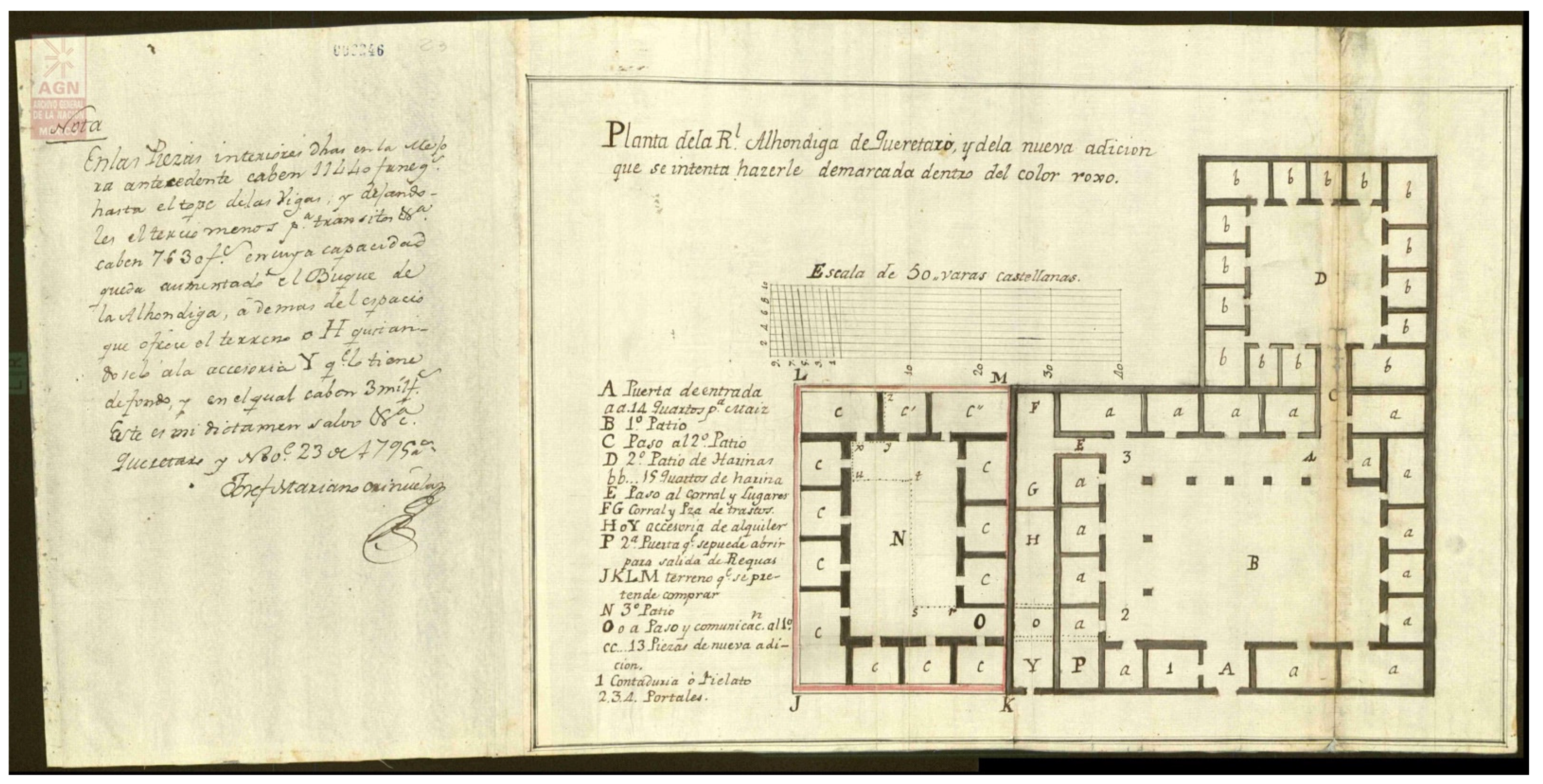
31
See “Real Alhóndiga de Querétaro, Qro,” 23 November 1795, 30.5 × 62.5 cm. AGN, Mapas, Planos e Ilustraciones.
32
The idea of building a new granary in Zacatecas was first proposed by intendente Felipe Cleere soon after his arrival in the province in 1789, when he petitioned the authorities of the Real Audiencia of Nueva Galicia in Guadalajara for its construction (BPEJ, Ramo Civil, caja 202, exp. 25). A few months later, he proposed the construction of a new granary along with repairs to other public works. “Not having here [in Zacatecas] a subject capable of forming a map of the alhóndiga” (no habiendo aquí sujeto capaz de formar un mapa de la alhóndiga), Cleere asserted, he took matters into his own hands. Guided “by some principals and architectural practice”, he discussed the storerooms and other spaces that were necessary for the new Zacatecas alhóndiga, in consultation “with the workers and experienced individuals of the country” (con los operarios y personas experimentadas del país). As a result, he estimated the cost of a new granary to be 60,000 pesos (AGN, Obras Públicas, vol. 31, exp. 9, fols. 103r–103v).
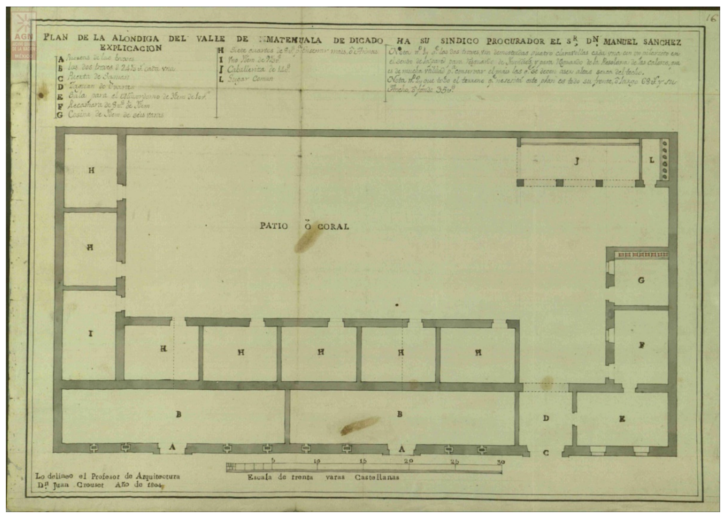
33
In a carefully drafted drawing (37.3 × 53.7 cm) that evinces his academic training and where he identifies himself as “profesor de arquitectura” (professor of architecture), Crouset planned a building of 68 × 35 varas. It comprised two large storerooms of 24 varas each with independent access from the main façade, eight smaller rooms enclosing an interior patio on three sides, and other auxiliary spaces for the granary’s administrator. See “Alhóndiga de valle de Matehuala, S.L.P.” AGN, Mapas Planos e Ilustraciones.
34
He is one of the architects involved in repairing the fountains of Mexico City’s Plaza Mayor in the first decade of the nineteenth century, as well as assessing the damage caused by the 1800 earthquake to the city’s buildings and infrastructure. In 1804, contemporary to the designs of the alhóndiga, he was also drawing new plans for Querétaro’s alameda (AGN, Obras Públicas, vol. 36, exp. 18, fols. 402–20; AGN, Obras Públicas, vol. 6, exp. 16, fols. 290–336; AGN, Obras Públicas, vol. 37, exp. 13, fols. 116–65).
35
Two of these drawings are of similar size: plan of the first floor (48 × 59.3 cm) and plan of the second floor (47.7 × 58 cm); while the third one (section of the building and elevation of the façade) is slightly smaller (48.4 × 52 cm). See AGN, Mapas, Planos e Ilustraciones (280)/MAPILU/210100/2856Alhóndiga de Querétaro. Qro. (2698); Mapas, Planos e Ilustraciones (280)/MAPILU/210100/2857Alhóndiga de Querétaro. Qro. (2699); and Mapas, Planos e Ilustraciones (280)/MAPILU/210100/2858Fachada de la Alhóndiga de Querétaro. Qro. (2700).
36
See Plan of a Monumental Staircase, completed by José María Casas in 1805, and the Section of the Caserta Palace, dated 1808 and authored by José María Echeandía. All these drawings, today preserved in Mexico City’s Archivo de la Antigua Academia de San Carlos, are reproduced in Fuentes Rojas 2002, pp. 131, 181, 234, 237–39.
37
Vitruvius recommended granaries to be set in an elevated position “with a northern or north-eastern exposure, so that the grain will not be able to heat quickly, but, being cooled by the wind, keeps a long time” (Vitruvius 1787, p. 154). These ideas were reiterated in the treatises of Renaissance and eighteenth-century architects. Alberti and Palladio recommended the same attention to the ventilation of the facilities and also advocated for the use of bricks in the paving of the trojes (storage rooms) to prevent moisture (Alberti 1581, pp. 144, 156; Palladio 1797, pp. 57–58). Building upon this architectural theory, Spanish mathematician and architect Benito Bails also urged the use of “the driest material that can be found” for the construction of granaries, particularly in the flooring, avoiding flagstones “because these, in the same way as any kind of stone, are easily soaked by moisture” (Bails 1783, p. 853). Along with a masonry foundation and walls, other elements of the architectural design introduced by Ciprés and Ortiz in their projected granaries of Guadalajara and Querétaro were aimed at implementing dryness. Enlarging the size of the trojes (storerooms), raising their flooring (one vara above the general floor for Querétaro’s alhóndiga), elevating their ceilings (up to nine varas in the granary of Guadalajara), and considering their exposure and orientation (allowing “the winds free for light and ventilation” in the words of Ciprés) were intended to facilitate airflow and protect the stored grain from humidity (AGN, Obras Públicas, vol. 23, exp. 5, fol. 169r; Chávez Orozco 1956, pp. 42–43).
38
Editions in Spanish of both treatises by Vitruvius and Vignola were published in the eighteenth century and were used for educational purposes in the Mexican Academy: Marcos Vitruvio Polión, Los Diez Libros de Architectura (Madrid, 1787) and Jacopo Barozzi da Vignola, Reglas de los Cinco Órdenes de Arquitectura de Vignola (Madrid, 1792). These books also circulated in the provinces of New Spain and were owned and collected by the elite. See (Bernstein 1946; García Melero 2002, pp. 38–53; Chanfón Olmos 2004, pp. 179–84).
39
When describing the patio in their 1805 report, Ortiz and Pérez stressed this simplicity and clarity of lines in its design, only interrupted by the “small ornament” of stone drops laid in headers over the lintels. Of ancient origin, these forms occurred in Doric cornice (Archivo Histórico de la Universidad de Guanajuato (AHUG), Alhóndiga (2a), Caja 3, 1805-08, fols. 3v–11v).
40
The use of this Spanish cursive letter suggests a familiarity with eighteenth-century studies to reform handwriting, such as the work of Spanish calligrapher Francisco Javier de Santiago Palomares, who in 1776 published the treatise Arte nueva de escribir. Treatises on handwriting circulated in New Spain in the late eighteenth century. In addition, as art historian Kelly Donahue-Wallace has recently studied, the ideas of Palomares had a strong impact on the work of Jerónimo Antonio Gil, with whom he shared a professional relationship and interest in typeface design prior to the latter’s departure to Mexico City in 1778 and his later appointment as director general of the Royal Academy of San Carlos, where Ortiz and other architecture students trained (Donahue-Wallace 2017, pp. 107–13).
41
Mexican historian Lucas Alamán, native to Guanajuato, attributed this negative opinion to his father Juan Vicente Alamán and recalled the episode in the following terms: “My father, despite the friendship he had with the intendente [Riaño], disapproved of the construction of this building, considering it preferable that the funds invested in it, coming from a contribution of two reales in each load of maize that was introduced in Guanajuato, be spent [on] making the road that was later began on the hills to the north of the ravine, to avoid the transit through it, very dangerous in times of water, which was the object with which the contribution was imposed, and censuring sharply the too luxurious architecture and ornaments, he said that Mr. Riaño was building a palace for the maize.”
42
In 1786, local master mason Juan Rodríguez was first commissioned by the cabildo of Durango to elaborate a budget and two plans for the new construction intended to include, among others, the residence of the intendente, the city hall, the customhouse, and the tobacco factory. See AGN, Obras Públicas, vol 25, exp. 2.
43
Unfortunately, the whereabouts of the drawings are unknown. They were commissioned in 1800 by the intendente Bonavía, per order of Nemesio Salcedo, Comandante General (Commandant-General) of the Internal Provinces of New Spain, and Mexico City’s Junta Superior de Real Hacienda. Durango’s cabildo refused to pay Tolsa’s honorarium because it had not commissioned the plans and had limited funds. After the case was reviewed, the city was ordered to pay. Durango’s cabildo reluctantly obeyed and requested the drawings to be returned from Mexico City in order to be kept in the municipal archive, suspending payment until their arrival. By June 1804, the plans had not appeared, and therefore intendente Bonavía suggested that a new copy be made by Tolsá and be paid for by whoever was guilty of losing the first drawings. Comandante Salcedo ordered an inquiry into the offices that had reviewed them in Mexico City, but all of them denied possession. In late 1805, Tolsá, then director of the Mexican Academy, protested the unacceptable delay in payment. The plans, which included guidelines and the dimensions of the site, had been commissioned by the intendente more than six years earlier. Clearly, Tolsá did not travel to Durango for the design of the building. According to his own testimony, he completed two sets of drawings. The first followed the instructions received from Durango; the second was based on Tolsá’s own judgment, as he expressed it, considering it a better arrangement for the offices. This latter drawing, Tolsá stated, was enthusiastically received by the intendente in Durango “giving me thanks for the improvements noted in the last [version].” Tolsá argued that he had only charged 500 pesos when the just price would have been 800 pesos for a building that was intended to house the residence of the intendente, the city hall, a jail for men and women, quarters for royal officials, the royal assay establishment, the alhóndiga with the dwelling of its administrator, chapel, and other adjacent spaces. Tolsá concluded that he was not to blame for the loss of the plans he carefully elaborated and that even if he agreed to provide new copies as a courtesy of his service to the king and the public, he had neither the drafts he used nor the dimensions of the site. Therefore, he implored for his honorarium to be paid without further delay. Comandante Salcedo passed the order to the intendente Bonavía on the last day of 1805. We do not know if the plans ever appeared, but presumably the city of Durango paid, as no further exchange of documentation on this matter exists (AGN, Obras Públicas, vol. 16, exp. 1, fols. 1r–9v).

References

  1. Archival and Unpublished Sources

    Archivo General de la Nación, Mexico City (AGN)
    • Caminos y Calzadas, vol. 22, exp. 4, fols. 81–94.
    • Alhóndigas, vol. 1, exp. 4, fols. 38–50.
    • Obras Públicas, vol. 6, exp. 16, fols. 290–336.
    • Obras Públicas, vol. 12, exp. 19, fols. 320–31.
    • Obras Públicas, vol. 12, exp. 21, fols. 348r–374v.
    • Obras Públicas, vol. 16, exp. 1, fols. 1r–9v.
    • Obras Públicas, vol. 23, exp. 5, fols. 162–215.
    • Obras Públicas, vol. 25, exp. 2.
    • Obras Públicas, vol. 25, exp. 6, fols. 211r–234r.
    • Obras Públicas, vol. 25, exp. 8, fols. 304r–317r.
    • Obras Públicas, vol. 25, exp. 10, fols. 333r-359v.
    • Obras Públicas, vol. 31, exp. 9, fols. 101–9.
    • Obras Públicas, vol. 36, exp. 6, fols. 87–125.
    • Obras Públicas, vol. 36, exp. 18, fols. 402–20.
    • Obras Públicas, vol. 37, exp. 13, fols. 116–65.
    • Indiferente Virreinal, Caja 3374, Expediente 042 Alhóndigas
    • Mapas Planos e Ilustraciones (280)
    Archivo General de Indias, Seville (AGI)
    • MP-MEXICO,153
    • MP-MEXICO,456BIS
    • MP-MEXICO,773
    Archivo Histórico de la Universidad de Guanajuato, Guanajuato (AHUG)
    • Alhóndiga (2a), Caja 3, 1793–1809
    • Alhóndiga (2a), Caja 3, 1805–08
    Biblioteca Pública del Estado de Jalisco, Guadalajara (BPEJ).
    • Archivo de la Real Audiencia de Nueva Galicia, Bienes de Difuntos, caja 220, exp. 25
    • Archivo de la Real Audiencia de Nueva Galicia, Bienes de Difuntos, caja 272, exp. 6
    • Archivo de la Real Audiencia de Nueva Galicia, Ramo Civil, caja 202, exp. 25
    • Archivo de la Real Audiencia de Nueva Galicia, Ramo Civil, caja 416, exp. 7
    Sagrario Metropolitano, Guadalajara. Available at familysearch.org.
    • Registros parroquiales. Bautismos 1759–1765
    • Registros parroquiales. Bautismos 1793–1799
    • Registros parroquiales. Bautismos 1799–1806
    • Registros parroquiales. Bautismos 1810–1815
    • Registros parroquiales. Defunciones 1798–1829
  2. Published Sources

  3. Alamán, Lucas. 1849. Historia de Méjico desde los Primeros Movimientos que Prepararon su Independencia en el año de 1808 hasta la época Presente. Mexico City: Imprenta de J. M. Lara. [Google Scholar]
  4. Alberti, Leon Battista. 1581. Los Diez Libros de Architectura de Leon Baptista Alberto. Madrid: En casa de Alonso Gomez. [Google Scholar]
  5. Arenas Sánchez, José. 1969. Historia de la Alhóndiga de Granaditas. Guanajuato: Universidad de Guanajuato, Archivo Histórico. [Google Scholar]
  6. Arrom, Silvia Marina. 2001. Containing the Poor. The Mexico City Poor House, 1774–1871. Durham: Duke University Press. [Google Scholar]
  7. Ayón Zester, Francisco. 1988. Paseo Filipense. Una Historia de la calle San Felipe. Guadalajara and Mexico City: Ayuntamiento de Guadalajara. [Google Scholar]
  8. Báez Macías, Eduardo. 1972. Guía del Archivo de la Antigua Academia de San Carlos, 1801–1843. Mexico City: Universidad Nacional Autónoma de México, Instituto de Investigaciones Estéticas. [Google Scholar]
  9. Báez Macías, Eduardo. 1974. Fundación e historia de la Academia de San Carlos. Mexico City: Departamento del Distrito Federal. [Google Scholar]
  10. Bails, Benito. 1783. Elementos de Matemática. Tomo IX, Parte I. Que Trata de la Arquitectura Civil. Madrid: Por Don Joachin Ibarra. [Google Scholar]
  11. Barteet, C. Cody. 2019. Architectural Rhetoric and the Iconography of Authority in Colonial Mexico. The Casa de Montejo. New York: Routledge. [Google Scholar]
  12. Bernstein, Harry. 1946. A Provincial Library in Colonial Mexico, 1802. Hispanic American Historical Review 26: 162–83. [Google Scholar] [CrossRef] [Green Version]
  13. Bielfeld, Jacob Friedrich. 1767. Instituciones Política: Obra en que se trata de la Sociedad Civil, de las leyes, de la Policía, de la Real Hacienda, del Comercio, y fuerzas de un estado. Madrid: en la imprenta de Gabriel Ramírez. [Google Scholar]
  14. Boils Morales, Guillermo. 1994. Arquitectura y Sociedad en Querétaro (siglo XVIII). Mexico City: Instituto de Investigaciones Sociales; Archivo Histórico del Estado. [Google Scholar]
  15. Brown, Thomas. 1976. La Academia de San Carlos de la Nueva España. Mexico City: Secretaría de Educación Pública. [Google Scholar]
  16. Burke, Juan Luis. 2021. Architecture and Urbanism in Viceregal Mexico: Puebla de los Ángeles, Sixteenth to Eighteenth Centuries. New York: Routledge. [Google Scholar]
  17. Calvo, Thomas. 2010. Ciencia, cultura y política ilustradas (Nueva España y otras partes). In Las reformas borbónicas, 1750–1808. Edited by Clara García Ayluardo. Mexico City: CIDE, FCE, Conaculta, INEHRM, Fundación Cultural de la Ciudad de México, pp. 83–130. [Google Scholar]
  18. Camacho Becerra, Arturo. 1997. Álbum del Tiempo Perdido. Pintura Jalisciense del siglo XIX. Guadalajara: El Colegio de Jalisco. [Google Scholar]
  19. Camacho Cárdenas, Enrique. 2012. El proceso constructivo del Sagrario Metropolitano de Guadalajara: la llegada de José Gutiérrez y el inicio de la arquitectura neoclásica en la ciudad. Anales del Instituto de Investigaciones Estéticas 34: 81–108. Available online: http://www.scielo.org.mx/scielo.php?script=sci_arttext&pid=S0185-12762012000200004#nota (accessed on 20 December 2021).
  20. Candiani, Vera. 2014. Dreaming of Dry Land. Environmental Transformation in Colonial Mexico City. Stanford: Stanford University Press. [Google Scholar]
  21. Castañeda, Carmen. 2002. Los intendentes en el gobierno de Guadalajara, 1790–1809. Anuario de Estudios Americanos 59: 67–80. [Google Scholar] [CrossRef]
  22. Castañeda, Carmen. 2005. Huellas de impresores, imprentas y autores alemanes en la Nueva España: el caso de la imitación de Cristo. In Alemania y México. Percepciones mutuas en impresos, siglos XVI–XVIII. Edited by Horst Pietschmann, Manuel Ramos Medina and Marí Cristina Torales Pacheco. Mexico City: Universidad Iberoamericana, pp. 219–36. [Google Scholar]
  23. Chanfón Olmos, Carlos, ed. 2004. Historia de la Arquitectura y el Urbanismo Mexicanos. Mexico City: Universidad Nacional Autónoma de México; Fondo de Cultura Económica, vol. II, tome III. [Google Scholar]
  24. Chávez Orozco, Luis, ed. 1956. Documentos sobre la Alhóndiga de Guadalajara. Mexico City: Almacenes Nacionales de Depósito. [Google Scholar]
  25. Cordero Herrera, Alicia Leonor. 2013. Felipe Cleere, oficial real, Intendente y Arquitecto, entre la Ilustración y el Despotismo. Ph.D. thesis, Universidad Nacional Autónoma de México, Mexico City, Mexico. Available online: https://ru.dgb.unam.mx/handle/DGB_UNAM/TES01000703958 (accessed on 20 December 2021).
  26. Cornejo Franco, José, Francisco Ayón Zester, and Lucía Arévalo Vargas. 1985. Obras Completas, tomo II. Guadalajara: Gobierno del Estado de Jalisco. [Google Scholar]
  27. Diario de México: Dedicado al Exmô. Señor Don Jose de Yturrigaray, Caballero Profeso del Orden de Santiago...: Tomo V. 1807. Mexico City: en la imprenta de la calle de Santo Domingo.
  28. Donahue-Wallace, Kelly. 2017. Jerónimo Antonio Gil and the Idea of the Spanish Enlightenment. Albuquerque: University of New Mexico Press. [Google Scholar]
  29. Fernández, Martha. 1986. El albañil, el arquitecto y el alarife en la Nueva España. Anales del Instituto de Investigaciones Estéticas 14: 49–68. [Google Scholar] [CrossRef] [Green Version]
  30. Florescano, Enrique. 1969. Precios del maíz y crisis agrícolas en México (1708–1810). Mexico City: El Colegio de México. [Google Scholar]
  31. Fuentes Rojas, Elizabeth. 2002. La Academia de San Carlos y los Constructores del Neoclásico. Primer Catálogo de Dibujo Arquitectónico, 1779–1843. Mexico City: Universidad Nacional Autónoma de México. [Google Scholar]
  32. Gálvez Ruiz, María Ángeles. 1993. La Consolidación de la Conciencia Regional en Guadalajara: El Gobierno del Intendente Jacobo Ugarte y Loyola, (1791–1798). Ph.D. dissertation, Universidad de Granada, Granada, Spain. Available online: https://digibug.ugr.es/handle/10481/14312 (accessed on 20 December 2021).
  33. García, Virginia. 1987. El almacenamiento de granos a gran escala para abastecer a la capital virreinal. In Almacenamiento de Productos Agropecuarios en México. Edited by Gail Mummert. Zamora: El Colegio de Michoacán, Almacenes Nacionales de Depósito, S.A, pp. 45–62. [Google Scholar]
  34. García Melero, José Enrique. 2002. Literatura Española sobre artes Plásticas. Volumen I: Bibliografía Aparecida en España entre los siglos XVI y XVIII. Madrid: Encuentro. [Google Scholar]
  35. Glasco, Sharon Bailey. 2010. Constructing Mexico City: Colonial Conflicts over Culture, Space, and Authority. New York: Palgrave MacMillan. [Google Scholar]
  36. González Franco, Glorinela, María del Carmen Olvera Calvo, and Ana Eugenia Reyes y Cabañas. 1994. Artistas y Artesanos a Través de Fuentes Documentales. Volumen I. Ciudad de México. Mexico City: Instituto Nacional de Antropología e Historia. [Google Scholar]
  37. Gordo Peláez, Luis. 2010. Equipamientos y edificios municipales en la Corona de Castilla en el siglo XVI. Ph.D. dissertation, Universidad Complutense de Madrid, Madrid, Spain. Available online: https://eprints.ucm.es/id/eprint/10840/ (accessed on 20 December 2021).
  38. Gordo Peláez, Luis. 2013. ‘A Palace for the Maize’: The Granary of Granaditas in Guanajuato and Neoclassical Civic Architecture in Colonial Mexico. RACAR: Revue d’art Canadienne/Canadian Art Review 38: 71–89. Available online: http://www.jstor.org/stable/42630895 (accessed on 20 December 2021).
  39. Gutiérrez Lorenzo, María del Pilar. 2007. Educación, ilustración, e independencia en Guadalajara de Indias: la impronta del obispo navarro Juan Cruz Ruiz de Cabañas (1790–1824). In De ida y vuelta. América y España. Los Caminos de la Cultura. Edited by Pilar Cagiao Vila and Eduardo Rey Tristán. Santiago de Compostela: Universidade de Santiago de Compostela, pp. 59–72. [Google Scholar]
  40. Hernández Soubervielle, José Armando. 2013a. Un rostro de piedra para el poder. Las Nuevas Casas Reales de San Luis Potosí, 1767–1827. San Luis Potosí: El Colegio de San Luis, Zamora: El Colegio de Michoacán. [Google Scholar]
  41. Hernández Soubervielle, José Armando. 2013b. De piedra y maíz. Las Alhóndigas y el Abastecimiento de granos en San Luis Potosí Durante el Virreinato. San Luis Potosí: El Colegio de San Luis. [Google Scholar]
  42. Muñoz Andrade, Angélica Primavera. 2020. La Casa de la Misericordia. Una Solución a la Pobreza en Guadalajara. Guadalajara: Editorial Universidad de Guadalajara. [Google Scholar]
  43. Muratori, Luis Antonio. 1790. La Publica Felicidad. Objeto de los Buenos Príncipes. Madrid: Imprenta Real. [Google Scholar]
  44. Niell, Paul. 2015. Urban Space as Heritage in Late Colonial Cuba. Classicism and Dissonance on the Plaza de Armas of Havana, 1754–1828. Austin: University of Texas Press. [Google Scholar]
  45. Ortiz Macedo, Luis. 2004. La Historia del Arquitecto Mexicano. Siglos XVI–XX. Mexico City: Grupo Editorial Proyección de México. [Google Scholar]
  46. Palladio, Andrea. 1797. Los Quatro Libros de Arquitectura de Andres Paladio, Vicentino. Traducidos e Ilustrados con notas por Don Joseph Francisco Ortiz y Sanz. Madrid: Imprenta Real. [Google Scholar]
  47. Paquette, Gabriel. 2008. Enlightenment, Governance, and Reform in Spain and Its Empire, 1759–1808. New York: Palgrave MacMillan. [Google Scholar]
  48. Pietschmann, Horst. 1996. Las Reformas Borbónicas y el Sistema de Intendencias en Nueva España. Mexico City: Fondo de Cultura Económica. [Google Scholar]
  49. Ramírez Montes, Mina. 2010. José Mariano Oriñuela y su proyecto para el establecimiento de una Academia de Matemáticas en Querétaro. Anales del Instituto de Investigaciones Estéticas 97: 5–24. [Google Scholar] [CrossRef] [Green Version]
  50. Real Ordenanza para el Establecimiento e Instrucción de Intendentes de exercito y Provincia en el Reino de la Nueva-España. 1786. Madrid: Viuda de Joaquín Ibarra, Hijos y Compañía.
  51. Recopilación de leyes de los reinos de las Indias: Mandadas Imprimir y publicar por la Majestad Católica del rey Don Carlos II, nuestro señor. 1681. Madrid: Julián de Paredes.
  52. Rees Jones, Ricardo. 1979. El Despotismo Ilustrado y los Intendentes de la Nueva España. Mexico City: Universidad Nacional Autónoma de México. [Google Scholar]
  53. Ruiz Razura, Adriana. 2008. José Gutiérrez, El arquitecto malagueño del neoclásico en Guadalajara, México (1766–1835). Cuadernos de Estudios del siglo XVIII 18: 181–210. [Google Scholar] [CrossRef]
  54. Schreffler, Michael. 2007. The Art of Allegiance: Visual Culture and Imperial Power in Baroque New Spain. University Park: Pennsylvania State University Press. [Google Scholar]
  55. Schuetz, Mardith, ed. 1987. Architectural Practice in Mexico City: A Manuel for Journeyman Architects of the Eighteenth Century. Tucson, Arizona: University of Arizona Press. [Google Scholar]
  56. Suplemento a la Gazeta de México del martes 22 de agosto de 1786. 1786, In Gazeta de México: Compendio de Noticias de Nueva España. México: por D. Felipe de Zúñiga y Ontiveros, Calle del Espíritu Santo, [1784–1809], pp. 185–92.
  57. Terán, Marta. 2017a. El Testimonio del Consulado de Guadalajara de 1802 referente al puente de Calderón. Historiografía ¿sobre sus arcos? Historias 89: 55–78. Available online: https://www.revistas.inah.gob.mx/index.php/historias/article/view/11033 (accessed on 20 December 2021).
  58. Terán, Marta. 2017b. Testimonio del expediente instruido a efecto de indagar y saber la necesidad que hay, y utilidad que debe resultar de edificar los puentes de La Laxa y Calderón. Historias 89: 117–36. Available online: https://www.revistas.inah.gob.mx/index.php/historias/article/view/11037 (accessed on 20 December 2021).
  59. Toussaint, Manuel. 1948. La Catedral de México y el Sagrario Metropolitano: Su Historia, Su Tesoro, Su Arte. Mexico City: Comisión Diocesana de Orden y Decoro. [Google Scholar]
  60. Tovar Esquivel, Enrique, and Adriana Garza Luna. 2006. Juan Bautista Crouset, Maestro mayor de obras de Monterey. Boletín de Monumentos Históricos 8: 80–97. [Google Scholar]
  61. Van Young, Eric. 2006. Hacienda and Market in Eighteenth-Century Mexico: The Rural Economy of the Guadalajara Region, 1675–1820, 2nd ed. Lanham: Rowman & Littlefield Publishers. [Google Scholar]
  62. Vargas Chávez, Jaime Alberto. 2013. Arquitectura para la Administración Pública: Casas Reales Novohispanas siglo XVIII. Zamora: El Colegio de Michoacán. [Google Scholar]
  63. Viqueira Albán, Juan Pedro. 1999. Propriety and Permissiveness in Bourbon Mexico. Wilmington: Scholarly Resources. [Google Scholar]
  64. Vitruvius, Marcus. 1787. Los diez libros de architectura de M. Vitruvio Polion. Traducidos del latin y comentados por Don Joseph Ortiz y Sanz. Madrid: Imprenta Real. [Google Scholar]
  65. Wilkinson, Catherine. 1975. The Escorial and the Invention of the Imperial Staircase. The Art Bulletin 57: 65–90. [Google Scholar] [CrossRef]
Figure 1. Pierre Antoine Tardieu. A Map of Louisiana and Mexico. Carte de la Lousiane et du Mexique. Paris: chez P.A.F. Tardieu, Place de l’Estrapade Nº 34, 1820. Biblioteca Nacional de España, Madrid, Sala Goya. Cartografía, MV/23. Artwork in the public domain; image courtesy of the Biblioteca Nacional de España, Madrid. http://bdh-rd.bne.es/viewer.vm?id=0000037370&page=1 (accessed on 20 December 2021).
Arts 11 00042 g001
Figure 2. Pierre Antoine Tardieu. A Map of Louisiana and Mexico. Carte de la Lousiane et du Mexique. (detail with Guadalajara and Querétaro circled in red) Paris: chez P.A.F. Tardieu, Place de l’Estrapade Nº 34, 1820. Biblioteca Nacional de España, Madrid, Sala Goya. Cartografía, MV/23. Artwork in the public domain; image courtesy of the Biblioteca Nacional de España, Madrid.
Arts 11 00042 g002
Figure 3. Pedro José Ciprés, Plan of Guadalajara Alhóndiga, 1793, 55.8 × 44.2 cm. Archivo General de la Nación, Mexico City, Mapas, Planos e Ilustraciones (280)/MAPILU/210100/3623Alhóndiga de maíz; Guadalajara. Jal. (3374). Photograph used with permission of the Archivo General de la Nación.
Arts 11 00042 g003
Figure 4. William Henry Jackson, Portales (of the Alhóndiga) near the cathedral, San Luis Potosi, Mexico (1880–97). Photograph (between 1880 and 1897). Detroit Publishing Company photograph collection. Library of Congress Prints and Photographs Division Washington, D.C. Artwork in the public domain; image courtesy of the Library of Congress, Washington, D.C. https://www.loc.gov/item/2016817621/ (accessed on 20 December 2021).
Arts 11 00042 g004
Figure 5. José María Campos, Plan of Chihuahua Alhóndiga, 1800, 30 × 41 cm. Archivo General de la Nación, Mexico City, Mapas, Planos e Ilustraciones (280)/MAPILU/210100/2863Alhóndiga de Chihuahua. Chih. (2704). Photograph used with permission of the Archivo General de la Nación.
Arts 11 00042 g005
Figure 6. Pedro José Ciprés, “Plano Geométrico” (Geometrical Plan), Plan of Guadalajara Alhóndiga, Military Barracks, and Butcher Shop, 1797, 59.3 × 47 cm. Archivo General de la Nación, Mexico City, Mapas, Planos e Ilustraciones (280)/MAPILU/210100/4452/Alhóndiga, cuartel de milicias y carnicería, Guadalajara. Jal. (4178). Photograph used with permission of the Archivo General de la Nación.
Arts 11 00042 g006
Figure 7. Pedro José Ciprés, “Plano 2” (Plan 2), Plan of Guadalajara Alhóndiga, Military Barracks, and Butcher Shop, 1797, 35 × 44.5 cm. Archivo General de la Nación, Mexico City, Mapas, Planos e Ilustraciones (280)/MAPILU/210100/4453Alhondiga, cuartel de milicias y carnicería, Guadalajara. Jal. (4179). Photograph used with permission of the Archivo General de la Nación.
Arts 11 00042 g007
Figure 8. Plan of the Alhóndiga, Casas Reales, and Jail of the Real de Bolaños, 1753. Ministerio de Cultura y Deporte, Archivo General de Indias, Sevilla, MP-MEXICO,773.
Arts 11 00042 g008
Figure 9. José Mariano Oriñuela, Plan of Querétaro Alhóndiga, 1795, 30.5 × 62.5 cm. Archivo General de la Nación, Mexico City, Mapas, Planos e Ilustraciones (280)/MAPILU/210100/2862Real Alhóndiga de Querétaro. Qro. (2703). Photograph used with permission of the Archivo General de la Nación.
Arts 11 00042 g009
Figure 10. Juan Crouset, Plan of Valle de Matehuala Alhóndiga, San Luis Potosí, 1804, 37.3 × 53.7 cm. Archivo General de la Nación, Mexico City, Mapas, Planos e Ilustraciones (280)/MAPILU/210100/4634Alhóndiga de valle de Matehuala. S.L.P. (4357). Photograph used with permission of the Archivo General de la Nación.
Arts 11 00042 g010
Figure 11. Juan Bilbao, Plano Geográfico de la Ciudad de Santiago de Querétaro, Subdividido en tres Quarteles Mayores según lo está en la actualidad, 1817. Real Academia de la Historia—Colección: Sección de Cartografía y Artes Gráficas—Signatura: C-001-050—Signatura anterior: C-I a 50 p—Nº de registro: 00052. Artwork in the public domain; image courtesy of the Real Academia de la Historia, Madrid. https://bibliotecadigital.rah.es/es/consulta/registro.do?id=12519 (accessed on 20 December 2021).
Arts 11 00042 g011
Figure 12. Juan Bilbao, Plano Geográfico de la Ciudad de Santiago de Querétaro, Subdividido en tres Quarteles Mayores según lo está en la actualidad, 1817. (Detail with the alhóndiga of Querétaro circled in red.) Real Academia de la Historia—Colección: Sección de Cartografía y Artes Gráficas—Signatura: C-001-050—Signatura anterior: C-I a 50 p—Nº de registro: 00052. Artwork in the public domain; image courtesy of the Real Academia de la Historia, Madrid.
Arts 11 00042 g012
Figure 13. Manuel Alegre, The main staircase of the monastery of El Escorial, from a series of Views of El Escorial, ca. 1790–1800. Etching and Engraving. The Metropolitan Museum of Art, New York. Artwork in the public domain; image courtesy of The Metropolitan Museum of Art. https://www.metmuseum.org/art/collection/search/840900 (accessed on 20 December 2021).
Arts 11 00042 g013
Figure 14. Francisco Ortiz de Castro, Plan of Querétaro Alhóndiga (ground floor), 1804, 48 × 59.3 cm. Archivo General de la Nación, Mexico City, Mapas, Planos e Ilustraciones (280)/MAPILU/210100/2856Alhóndiga de Querétaro. Qro. (2698). Photograph used with permission of the Archivo General de la Nación.
Arts 11 00042 g014
Figure 15. Francisco Ortiz de Castro, Plan of Querétaro Alhóndiga (upper floor), 1804, 47.7 × 58 cm. Archivo General de la Nación, Mexico City, Mapas, Planos e Ilustraciones (280)/MAPILU/210100/2857Alhóndiga de Querétaro. Qro. (2699). Photograph used with permission of the Archivo General de la Nación.
Arts 11 00042 g015
Figure 16. Façade of Charcas Alhóndiga, province of San Luis Potosí, 1773, 20.3 × 30.5 cm. Archivo General de la Nación, Mexico City, Obras Públicas, vol. 36, exp. 6, fols. 87–125. Photograph by the author; used with permission of the Archivo General de la Nación.
Arts 11 00042 g016
Figure 17. Francisco Ortiz de Castro, Section of Querétaro Alhóndiga and elevation of its façade, 1804, 48.4 × 52 cm. Archivo General de la Nación, Mexico City, Mapas, Planos e Ilustraciones (280)/MAPILU/210100/2858Fachada de la Alhóndiga de Querétaro. Qro. (2700). Photograph used with permission of the Archivo General de la Nación.
Arts 11 00042 g017
Figure 18. Guanajuato Alhóndiga. North façade and portal, 1797–1809. Photograph by the author.
Arts 11 00042 g018
Figure 19. Guanajuato Alhóndiga. North portal, 1797–1809. Photograph by the author.
Arts 11 00042 g019
Publisher’s Note: MDPI stays neutral with regard to jurisdictional claims in published maps and institutional affiliations.

