Application of Multi-Source Remote Sensing and Topographic Factor Integration in the Exploration of Ion-Adsorption Type Rare Earth Deposits: A Case Study from Houaphanh Province, Laos
Abstract
1. Introduction
2. Regional Geological Setting
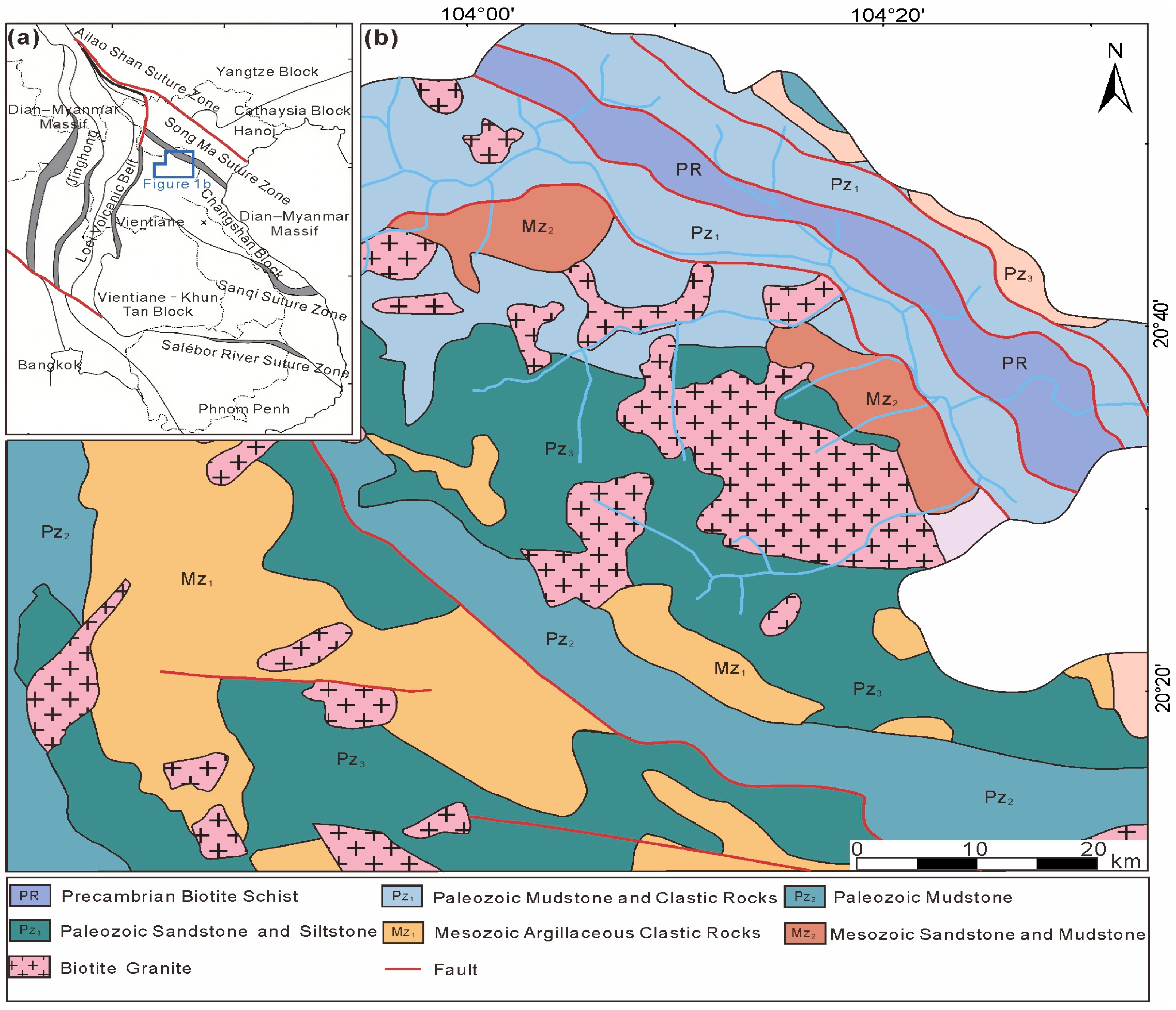
2.1. Geological Background
2.2. Genesis and Occurrence Conditions of Ion-Adsorption Type REE Deposits
2.3. Metallogenic-Potential of Ion-Adsorption Type REEs in Houaphanh, Laos
3. Methods
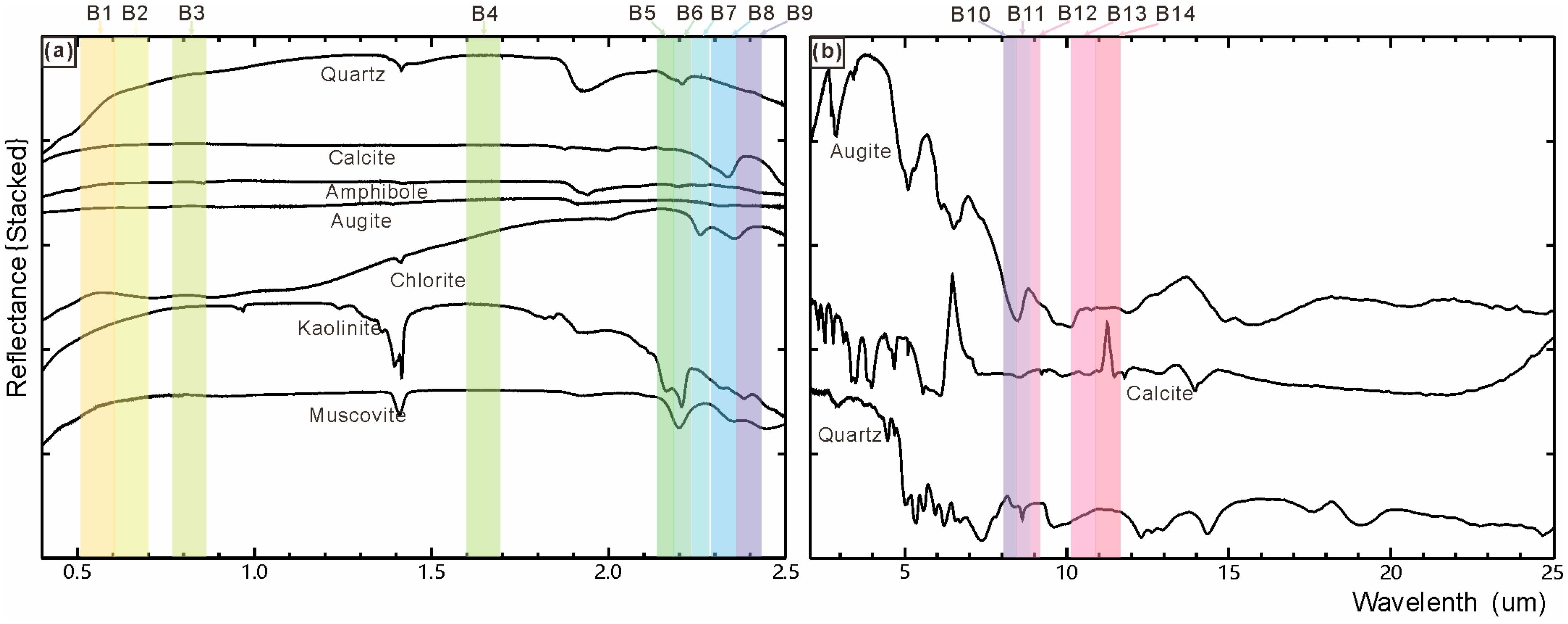
3.1. Remote Sensing Data and Preprocessing
3.2. Data Analysis Methods
3.2.1. Band Ratio Method
3.2.2. Principal Component Analysis (PCA)
3.2.3. Topographic Factor Analysis
4. Remote Sensing Interpretation Results
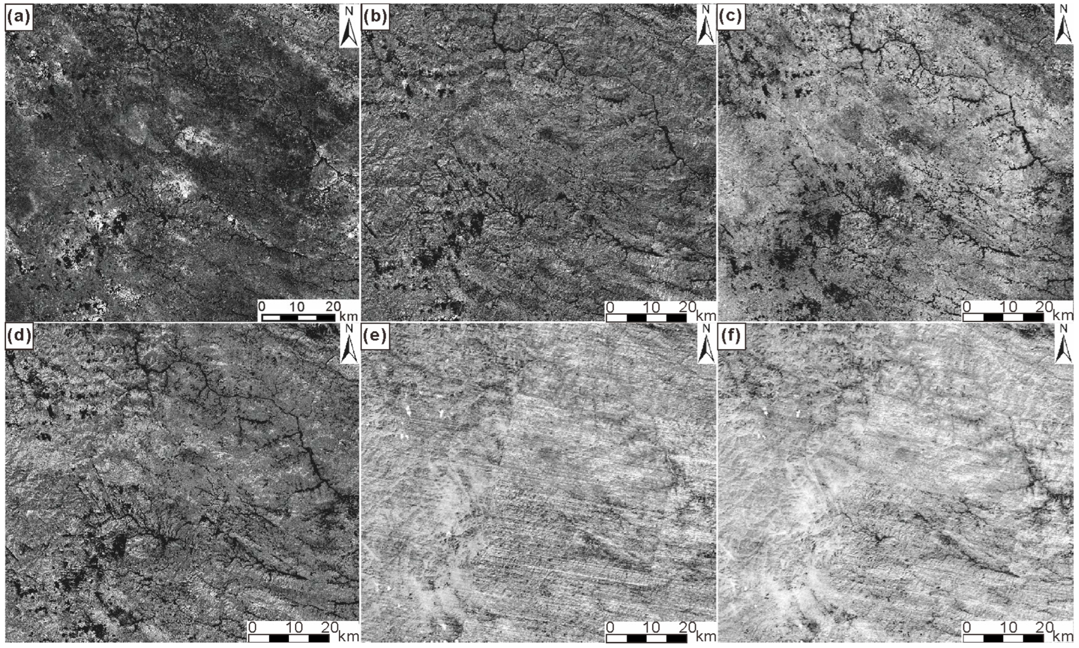
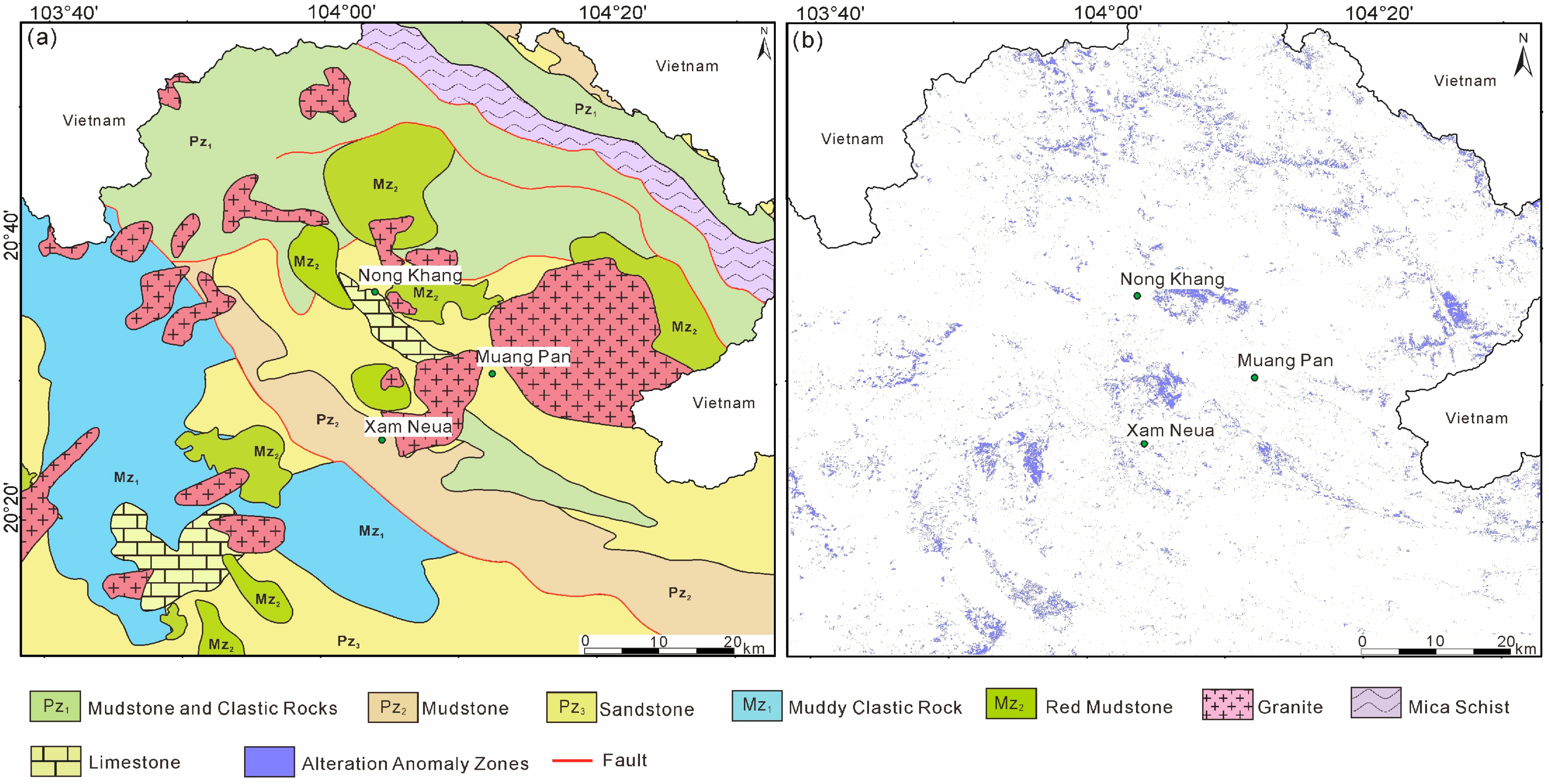
4.1. Lithological and Alteration Interpretation
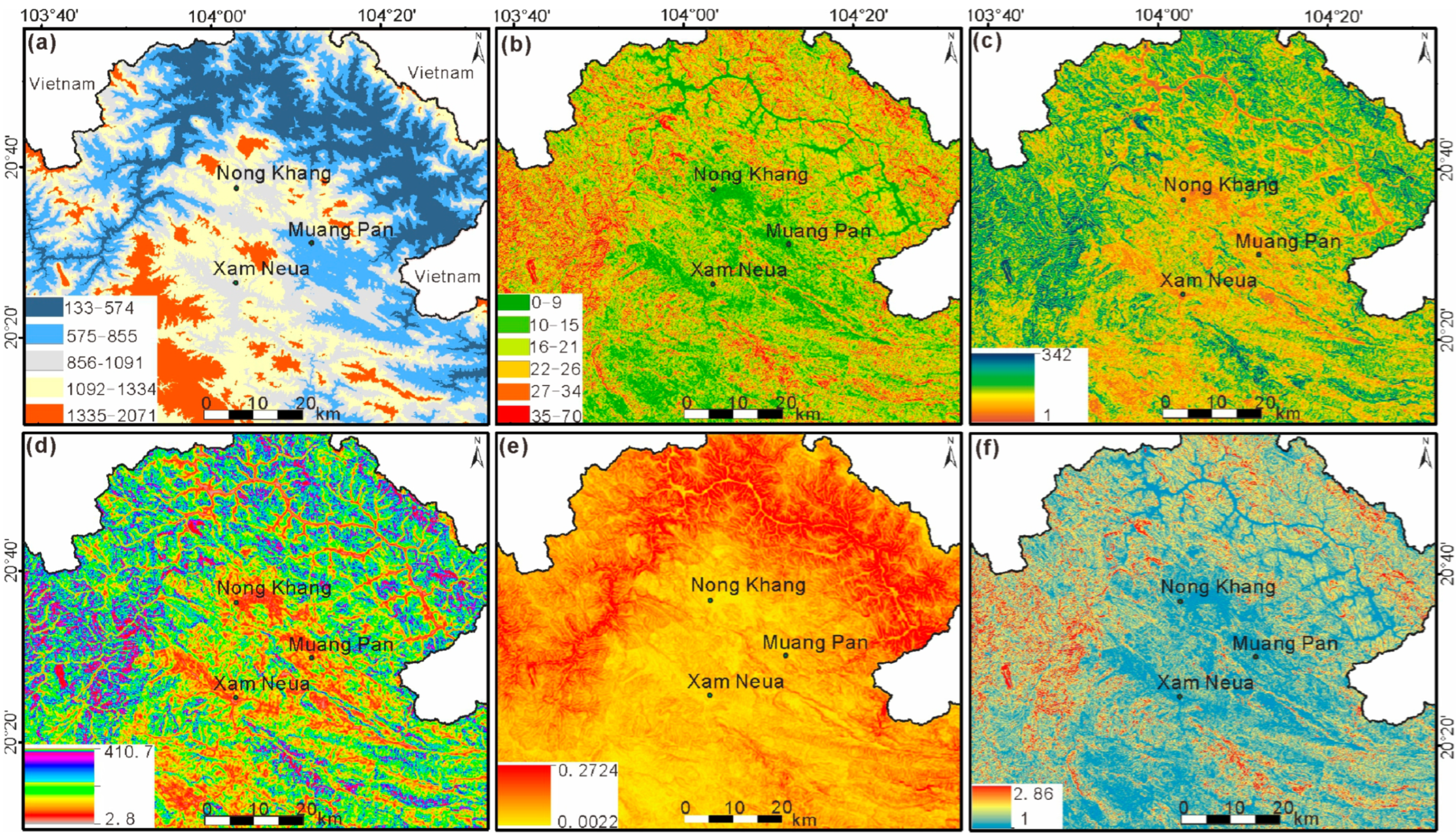
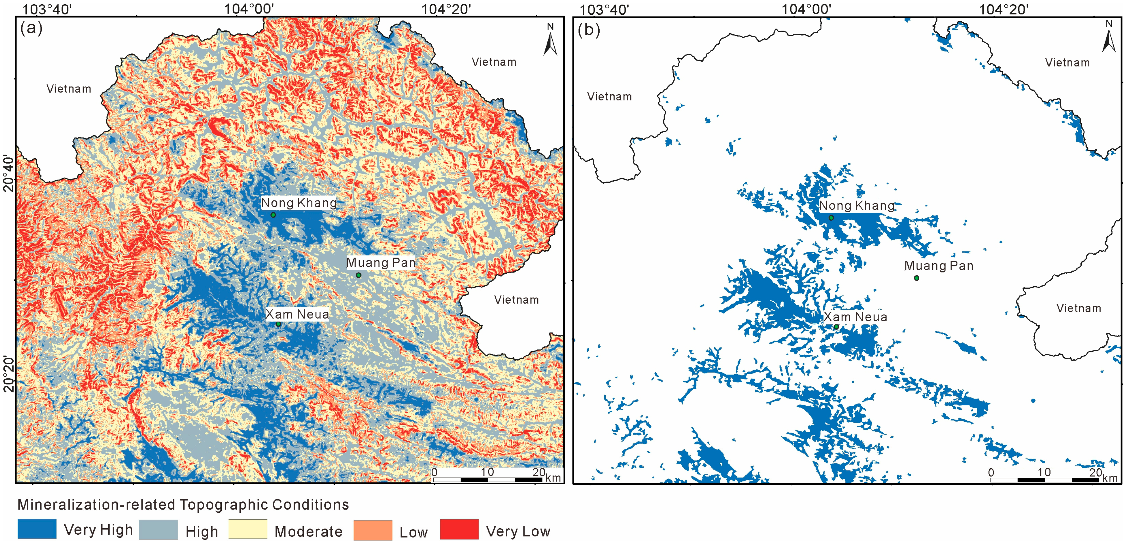
4.2. Results of Topographic Factor Analysis
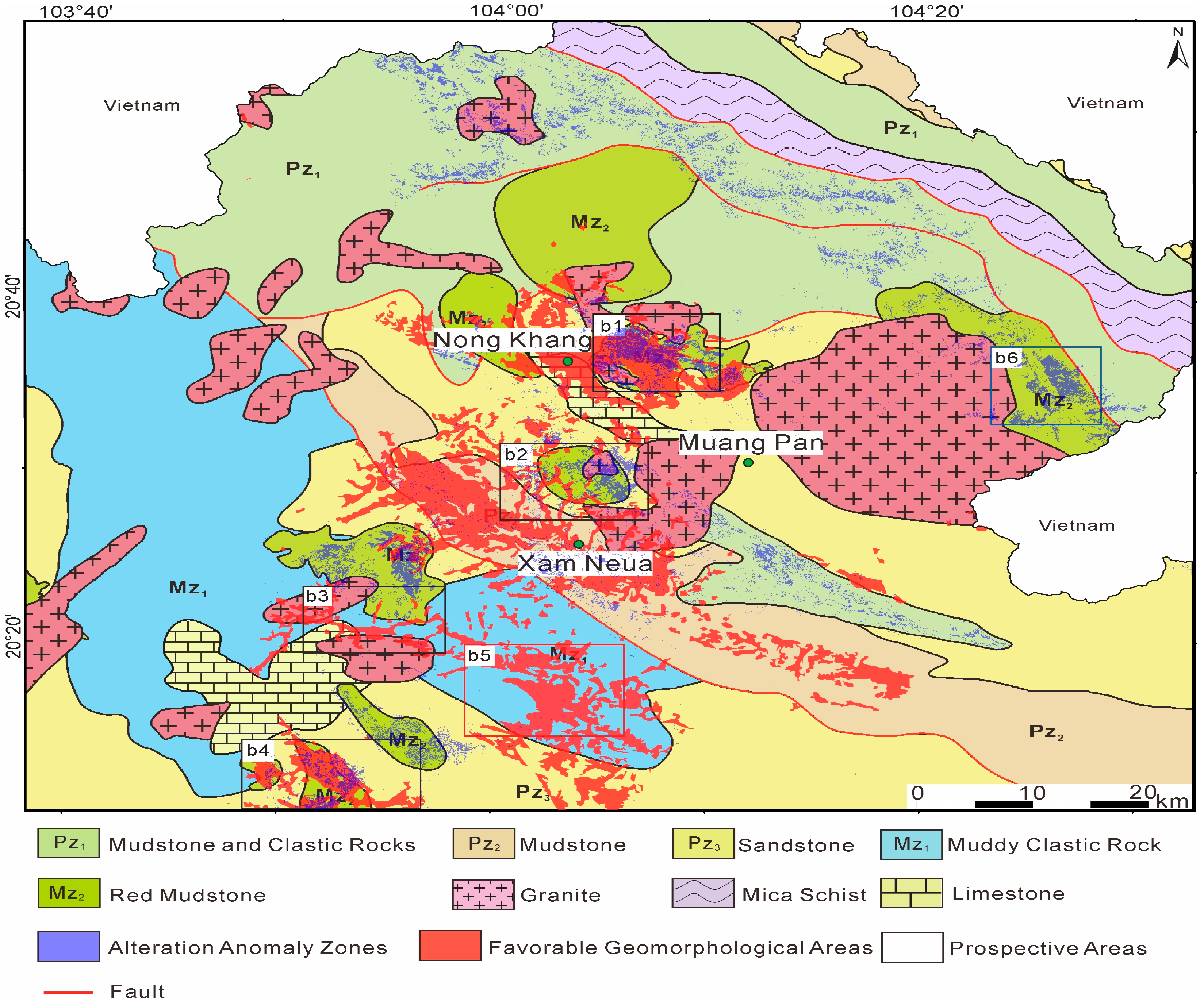
4.3. Integrated Interpretation Results
5. Prediction of Ion-Adsorption Type Rare Earth Deposits
5.1. Remote Sensing–Based Prospecting Model for Ion-Adsorption Type REEs
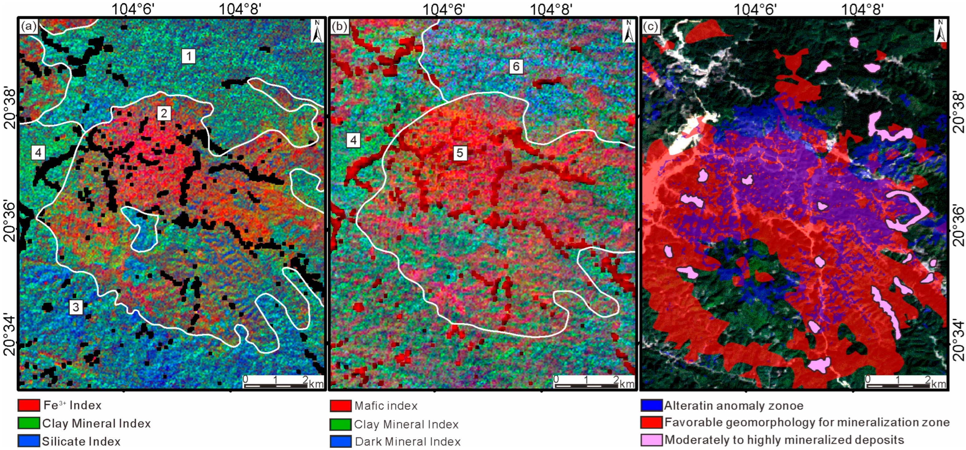
5.2. Integrated Overlay Analysis and Validation of Prediction Results
6. Conclusions
- Lithological and alteration information derived from ASTER and Landsat 9 imagery using band ratio and principal component analysis (PCA) effectively identified granitic and weathered crustal zones favorable for REE enrichment. When combined with key geomorphological parameters extracted from DEM data, these datasets provided a comprehensive framework for delineating potential mineralization zones
- The integrated analysis revealed strong consistency among lithological, alteration, and topographic indicators, defining six prospective areas. Field validation in the Nongkhang zone confirmed 19 IREE ore bodies within the predicted high-favorability zone, demonstrating the accuracy and practical applicability of this method. Integrating spectral and geomorphological information enhances the prediction of regolith-hosted REE deposits, particularly in tropical, densely vegetated regions where traditional surveys are constrained. Future work should incorporate higher-resolution hyperspectral data and advanced machine learning algorithms to refine the model further and improve exploration efficiency.
- Integrating spectral and geomorphological information enhances the prediction of regolith-hosted REE deposits, particularly in tropical, densely vegetated regions where traditional surveys are constrained. Future work should incorporate higher-resolution hyperspectral data and advanced machine learning algorithms to refine the model further and enhance prediction accuracy.
Author Contributions
Funding
Data Availability Statement
Conflicts of Interest
References
- Trench, A.; Zhang, L.; Groves, D.I.; Crook, D.; Brand, N.W. Australian Critical Metal Exploration for Analogues of Chinese Ionic-Clay REE Deposits. Geosyst. Geoenviron. 2025, 4, 100293. [Google Scholar] [CrossRef]
- Diao, H.; Yang, H.; Tan, T.; Ren, G.; You, M.; Wu, L.; Yang, M.; Bai, Y.; Xia, S.; Song, S.; et al. Navigating the Rare Earth Elements Landscape: Challenges, Innovations, and Sustainability. Miner. Eng. 2024, 216, 108889. [Google Scholar] [CrossRef]
- Liu, W.; Li, Y.; Wang, X.; Cui, L.; Zhao, Z.; Liu, C.; Xu, Z. Weathering Stage and Topographic Control on Rare Earth Element (REE) Behavior: New Constraints from a Deeply Weathered Granite Hill. Chem. Geol. 2022, 610, 121066. [Google Scholar] [CrossRef]
- Han, Z.; Lu, H.; Zhang, B.; Cheng, Z.; Fu, W.; Lao, C.; Xu, C. Delineating Preliminary Prospective Areas of Ion-Adsorption Rare Earth Deposits with Stream Sediments Geochemical Mapping in South China. J. Asian Earth Sci. 2023, 243, 105520. [Google Scholar] [CrossRef]
- Tian, S.; Liu, Z.; Mao, Q.; Ye, H.; Tian, C.; Zhu, Y.; Zhang, L. Leaching Characteristics and Environmental Impact of Heavy Metals in Tailings under Rainfall Conditions: A Case Study of an Ion-Adsorption Rare Earth Mining Area. Ecotoxicol. Environ. Saf. 2024, 281, 116642. [Google Scholar] [CrossRef] [PubMed]
- Amer, R.; Kusky, T.M. ASTER Analysis for Locating REE-Bearing Granites in Arid Regions: Example from the Arabian Shield. J. Earth Sci. 2022, 33, 1114–1123. [Google Scholar] [CrossRef]
- Lü, L.; Wang, S.; Zu, B.; Liu, J.; Zhang, G. Rare Earth Resources in Laos: Characteristics and the Prospects for Exploration and Development. Geol. Sci. Bull. 2022, 41, 20–31. [Google Scholar] [CrossRef]
- Wang, H.; Ling, F.C.; Li, X.Z.; Shi, M. The Division of Tectonic Units and Tectonic Evolution in Laos and Its Adjacent Regions. Geol. China 2015, 42, 71–84. (In Chinese) [Google Scholar]
- Rezaei, M.; Sanchez-Lecuona, G.; Abdolazimi, O. A Cross-Disciplinary Review of Rare Earth Elements: Deposit Types, Mineralogy, Machine Learning, Environmental Impact, and Recycling. Minerals 2025, 15, 720. [Google Scholar] [CrossRef]
- Chen, P.; Ilton, E.S.; Wang, Z.; Rosso, K.M.; Zhang, X. Global Rare Earth Element Resources: A Concise Review. Appl. Geochem. 2024, 175, 106158. [Google Scholar] [CrossRef]
- Cunningham, S.; Grammatikopoulos, T.; Almusned, B.; Henderson, J.D.; Azimi, G. Comprehensive Characterization and Extraction Implications of Ion Adsorption Rare Earth Deposit from a South American Source. Sci. Rep. 2025, 15, 29022. [Google Scholar] [CrossRef]
- Wu, P.; Li, X.; Liang, X.; Lin, X.; Zhu, J. Optimized Quantitative Analysis of Rare Earth Elements Associated with Typical Secondary Minerals in Regolith-Hosted Deposits. Chem. Geol. 2025, 691, 122942. [Google Scholar] [CrossRef]
- Guha, A.; Vinod Kumar, K. New ASTER Derived Thermal Indices to Delineate Mineralogy of Different Granitoids of an Archaean Craton and Analysis of Their Potentials with Reference to Ninomiya’s Indices for Delineating Quartz and Mafic Minerals of Granitoids—An Analysis in Dharwar Craton, India. Ore Geol. Rev. 2016, 74, 76–87. [Google Scholar] [CrossRef]
- Li, B.; Xie, H.; Liu, S.; Ye, Z.; Hong, Z.; Weng, Q.; Sun, Y.; Xu, Q.; Tong, X. Global Digital Elevation Model (GDEM) Product Generation by Correcting ASTER GDEM Elevation with ICESat-2 Altimeter Data. Earth Syst. Sci. Data 2025, 17, 205–220. [Google Scholar] [CrossRef]
- Kumar, C.; Chatterjee, S.; Oommen, T.; Guha, A. Automated Lithological Mapping by Integrating Spectral Enhancement Techniques and Machine Learning Algorithms Using AVIRIS-NG Hyperspectral Data in Gold-Bearing Granite-Greenstone Rocks in Hutti, India. Int. J. Appl. Earth Obs. Geoinf. 2020, 86, 102006. [Google Scholar] [CrossRef]
- Osinowo, O.O.; Gomy, A.; Isseini, M. Mapping Hydrothermal Alteration Mineral Deposits from Landsat 8 Satellite Data in Pala, Mayo Kebbi Region, Southwestern Chad. Sci. Afr. 2021, 11, e00687. [Google Scholar] [CrossRef]
- Yao, J.; Chao-lu, Y.; Ping, F. Evaluation of the Accuracy of SRTM3 and ASTER GDEM in the Tibetan Plateau Mountain Ranges. E3S Web Conf. 2020, 206, 01027. [Google Scholar] [CrossRef]
- Abdelkader, M.A.; Watanabe, Y.; Shebl, A.; El-Dokouny, H.A.; Dawoud, M.; Csámer, Á. Effective Delineation of Rare Metal-Bearing Granites from Remote Sensing Data Using Machine Learning Methods: A Case Study from the Umm Naggat Area, Central Eastern Desert, Egypt. Ore Geol. Rev. 2022, 150, 105184. [Google Scholar] [CrossRef]
- Gopinathan, P.; Parthiban, S.; Magendran, T.; Fadhil Al-Quraishi, A.M.; Singh, A.K.; Singh, P.K. Mapping of Ferric(Fe3+) and Ferrous(Fe2+) Iron Oxides Distribution Using Band Ratio Techniques with ASTER Data and Geochemistry of Kanjamalai and Godumalai, Tamil Nadu, South India. Remote Sens. Appl. Soc. Environ. 2020, 18, 100306. [Google Scholar] [CrossRef]
- Li, X.; Liu, X.; Jia, Z. DEM Geomorphological Features and Topographical Factor Analysis of Ion Adsorption Rare Earth Deposits in South China. South China Geol. 2023, 39, 376–386. [Google Scholar]
- Masek, J.G.; Wulder, M.A.; Markham, B.; McCorkel, J.; Crawford, C.J.; Storey, J.; Jenstrom, D.T. Landsat 9: Empowering Open Science and Applications through Continuity. Remote Sens. Environ. 2020, 248, 111968. [Google Scholar] [CrossRef]
- Shirmard, H.; Farahbakhsh, E.; Beiranvand Pour, A.; Muslim, A.M.; Müller, R.D.; Chandra, R. Integration of Selective Dimensionality Reduction Techniques for Mineral Exploration Using ASTER Satellite Data. Remote Sens. 2020, 12, 1261. [Google Scholar] [CrossRef]
- Zhao, C.; Xiao, Z.; Zhang, Y.; Yuan, C.; Yang, J. Alteration Mineral Information Extraction Based on Image Super-Resolution Technology. Int. J. Appl. Earth Obs. Geoinf. 2025, 144, 104872. [Google Scholar] [CrossRef]
- Zhang, T.; Zhao, Z.; Dong, P.; Tang, B.-H.; Zhang, G.; Feng, L.; Zhang, X. Rapid Lithological Mapping Using Multi-Source Remote Sensing Data Fusion and Automatic Sample Generation Strategy. Int. J. Digit. Earth 2024, 17, 2420824. [Google Scholar] [CrossRef]
- Ibrahim, M.; Al-Mashaqbah, A.; Koch, B.; Datta, P. An Evaluation of Available Digital Elevation Models (DEMs) for Geomorphological Feature Analysis. Environ. Earth Sci. 2020, 79, 336. [Google Scholar] [CrossRef]
- Wei, Y.; Gan, S.; Yuan, X.; Hu, L.; Gao, S. Analysis of Topographic Feature Parameters of Dinosaur Valley Ring Tectonic Geomorphology Based on the Advanced Land Observing Satellite Digital Elevation Model (ALOS DEM). Appl. Sci. 2023, 13, 13137. [Google Scholar] [CrossRef]
- Han, X.; Zhou, C.; Sun, S.; Lyu, C.; Gao, M.; He, X. An Ensemble Learning Framework for Generating High-Resolution Regional DEMs Considering Geographical Zoning. ISPRS J. Photogramm. Remote Sens. 2025, 221, 363–383. [Google Scholar] [CrossRef]
- Maxwell, A.E.; Shobe, C.M. Land-Surface Parameters for Spatial Predictive Mapping and Modeling. Earth-Sci. Rev. 2022, 226, 103944. [Google Scholar] [CrossRef]
- Hu, J.; Zhang, D.; Zhou, J.-X.; Wang, M. Identification of Regolith-Hosted Nb-REE Deposits in Alkaline Rocks Using Multisource Spectroscopic System: A Case Study of the Puxiong Deposit, Yunnan Province, China. Ore Geol. Rev. 2025, 186, 106860. [Google Scholar] [CrossRef]
- Huang, D.; Su, L.; Zhou, L.; Tian, Y.; Fan, H. Assessment of Gully Erosion Susceptibility Using Different DEM-Derived Topographic Factors in the Black Soil Region of Northeast China. Int. Soil Water Conserv. Res. 2023, 11, 97–111. [Google Scholar] [CrossRef]




| Band Number | Band Type | Wavelength Range (µm) | Off-Nadir Angle (°) | Spatial Resolution (m) |
|---|---|---|---|---|
| Band 1 (B1) | Visible and Near Infrared | 0.52–0.60 | +/−24 | 15 |
| Band 2 (B2) | Visible and Near Infrared | 0.63–0.69 | +/−24 | 15 |
| Band 3 (B3) | Visible and Near Infrared | 0.76–0.86 | +/−24 | 15 |
| Stereo Backward | Visible and Near Infrared | 0.76–0.86 | +/−24 | 15 |
| Band 4 (B4) | Shortwave Infrared | 1.60–1.70 | +/−8.55 | 30 |
| Band 5 (B5) | Shortwave Infrared | 2.145–2.185 | +/−8.55 | 30 |
| Band 6 (B6) | Shortwave Infrared | 2.185–2.225 | +/−8.55 | 30 |
| Band 7 (B7) | Shortwave Infrared | 2.235–2.285 | +/−8.55 | 30 |
| Band 8 (B8) | Shortwave Infrared | 2.295–2.365 | +/−8.55 | 30 |
| Band 9 (B9) | Shortwave Infrared | 2.360–2.430 | +/−8.55 | 30 |
| Band 10 (B10) | Thermal Infrared | 8.125–8.475 | +/−8.55 | 90 |
| Band 11 (B11) | Thermal Infrared | 8.475–8.825 | +/−8.55 | 90 |
| Band 12 (B12) | Thermal Infrared | 8.925–9.275 | +/−8.55 | 90 |
| Band 13 (B13) | Thermal Infrared | 10.25–10.95 | +/−8.55 | 90 |
| Band 14 (B14) | Thermal Infrared | 10.95–11.65 | +/−8.55 | 90 |
#Spectral Band | Req Min Lower Band Endge (nm) | Req Max Upper Band Edge (nm) | OLI Lower (nm) | OLI Upper (nm) | OLI-2 Lower (nm) | OLI-2 Upper (nm) |
|---|---|---|---|---|---|---|
| 433 | 453 | 435 | 451 | 435 | 450 |
| 450 | 515 | 452 | 512 | 452 | 512 |
| 525 | 600 | 533 | 590 | 532 | 589 |
| 630 | 680 | 636 | 673 | 636 | 672 |
| 845 | 885 | 851 | 879 | 850 | 879 |
| 1560 | 1660 | 1566 | 1651 | 1565 | 1651 |
| 2100 | 2300 | 2107 | 2294 | 2105 | 2294 |
| 500 | 680 | 504 | 676 | 503 | 675 |
| 1360 | 1390 | 1363 | 1384 | 1363 | 1384 |
| Eigenvectors | Band 1 | Band 2 | Band 3 | Band 4 |
|---|---|---|---|---|
| PC1 | 0.119601 | 0.094431 | 0.867118 | 0.474221 |
| PC2 | 0.225933 | 0.352579 | −0.488287 | 0.765649 |
| PC3 | −0.55244 | −0.706362 | −0.084464 | 0.434429 |
| PC4 | 0.793385 | −0.606484 | −0.050479 | 0.012974 |
| Eigenvectors | Band 1 | Band 4 | Band 6 | Band 7 |
|---|---|---|---|---|
| PC1 | 0.207602 | 0.81509 | 0.400395 | 0.363613 |
| PC2 | 0.125594 | −0.56802 | 0.534179 | 0.613377 |
| PC3 | 0.969494 | −0.09893 | −0.18084 | −0.13263 |
| PC4 | −0.03477 | 0.056523 | −0.72224 | 0.68845 |
Disclaimer/Publisher’s Note: The statements, opinions and data contained in all publications are solely those of the individual author(s) and contributor(s) and not of MDPI and/or the editor(s). MDPI and/or the editor(s) disclaim responsibility for any injury to people or property resulting from any ideas, methods, instructions or products referred to in the content. |
© 2025 by the authors. Licensee MDPI, Basel, Switzerland. This article is an open access article distributed under the terms and conditions of the Creative Commons Attribution (CC BY) license (https://creativecommons.org/licenses/by/4.0/).
Share and Cite
Ye, Y.; Li, C.; Vladmir Zerbo, O.R.; Yang, X.; Sun, W.; Xing, Y.; Qian, Y.; Yu, C. Application of Multi-Source Remote Sensing and Topographic Factor Integration in the Exploration of Ion-Adsorption Type Rare Earth Deposits: A Case Study from Houaphanh Province, Laos. Minerals 2025, 15, 1160. https://doi.org/10.3390/min15111160
Ye Y, Li C, Vladmir Zerbo OR, Yang X, Sun W, Xing Y, Qian Y, Yu C. Application of Multi-Source Remote Sensing and Topographic Factor Integration in the Exploration of Ion-Adsorption Type Rare Earth Deposits: A Case Study from Houaphanh Province, Laos. Minerals. 2025; 15(11):1160. https://doi.org/10.3390/min15111160
Chicago/Turabian StyleYe, Yakang, Chenwei Li, Ozias Rachid Vladmir Zerbo, Xinyu Yang, Wenbo Sun, Yifan Xing, Yujie Qian, and Cheng Yu. 2025. "Application of Multi-Source Remote Sensing and Topographic Factor Integration in the Exploration of Ion-Adsorption Type Rare Earth Deposits: A Case Study from Houaphanh Province, Laos" Minerals 15, no. 11: 1160. https://doi.org/10.3390/min15111160
APA StyleYe, Y., Li, C., Vladmir Zerbo, O. R., Yang, X., Sun, W., Xing, Y., Qian, Y., & Yu, C. (2025). Application of Multi-Source Remote Sensing and Topographic Factor Integration in the Exploration of Ion-Adsorption Type Rare Earth Deposits: A Case Study from Houaphanh Province, Laos. Minerals, 15(11), 1160. https://doi.org/10.3390/min15111160


