Article

Integrated Geophysical Signatures of the Jiaodong Region in China and Their Implications for Deep Architecture and Gold Metallogenic Systems

1
State Key Laboratory for Deep Earth and Mineral Exploration, Chinese Academy of Geological Sciences, Beijing 100094, China
2
Tianjin Center, China Geological Survey (North China Center for Geoscience Innovation), Tianjin 300170, China
3
School of Geophysics and Measurement & Control Technology, East China University of Technology, Nanchang 330013, China
4
Hohhot Natural Resources Comprehensive Survey Center, China Geological Survey, Hohhot 010013, China
*
Author to whom correspondence should be addressed.
Minerals 2025, 15(4), 417; https://doi.org/10.3390/min15040417
Submission received: 6 March 2025 / Revised: 10 April 2025 / Accepted: 14 April 2025 / Published: 17 April 2025

Abstract

:
The Jiaodong region ranks as the world’s third-largest gold metallogenic province, where Late Mesozoic gold mineralization exhibits close genetic connections with cratonic destruction and multi-stage plate tectonic interactions. This study systematically deciphers the deep-seated architecture and metallogenic controls through integrated analysis of gravity, aeromagnetic, and magnetotelluric datasets. The key findings demonstrate the following: (1) Bouguer gravity anomalies reveal a “two uplifts flanking a central depression” tectonic framework, reflecting superimposed effects from Yangtze Plate subduction and Pacific Plate rollback; (2) zoned aeromagnetic anomalies suggest that the Sanshandao–Jiaojia–Zhaoyuan–Pingdu Metallogenic Belt extends seaward with significant exploration potential; (3) magnetotelluric inversion identifies three lithosphere penetrating conductive zones, confirming the Jiaojia and Zhaoyuan–Pingdu faults as crust mantle fluid conduits, while the Taocun–Jimo fault marks the North China–Sulu Block boundary; and (4) metallogenic materials derive from hybrid sources of deep Yangtze Plate subduction and mantle upwelling, with gold enrichment controlled by intersections of NE-trending faults and EW-oriented basement folds. Integrated geophysical signatures indicate that the northwestern Jiaodong offshore area (north of Sanshandao) holds supergiant gold deposit potential. This research provides critical constraints for the craton destruction type gold mineralization model.

1. Introduction

The Jiaodong Peninsula constitutes China’s largest gold metallogenic province, with proven gold reserves reaching nearly 6000 metric tons [1], accounting for approximately one-third of the nation’s total resources. Recognized as the world’s third-largest gold district after South Africa’s Witwatersrand Basin and Uzbekistan’s Muruntau deposit, it uniquely hosts a Late Mesozoic giant gold province within Precambrian metamorphic terranes [2]. Prior to 2005, exploration primarily targeted shallow deposits (<500 m depth), whereas post-2005 investigations progressively extended to the 500–2000 m “secondary exploration space”. A breakthrough occurred in 2008 at the Jiaojia deposit, where cumulative gold resources exceeding 230 metric tons were delineated above −1330 m elevation, confirming significant mineralization potential at depth [3].
Previous studies on the metallogenesis and mineralization models of the Jiaodong gold deposits have extensively demonstrated their distinctiveness from classical orogenic gold deposits. These deposits are recognized as “Jiaodong-type gold deposits” or “cratonic destruction-type gold deposits” [4,5,6,7]. They are classified as non-intracontinental orogenic gold deposits associated with large-scale Mesozoic magmatism. The mineralization process was constrained by the tectonic transition regime in eastern North China during the Mesozoic, involving mantle upwelling, crust-mantle replacement, and subsequent magmatic–fluid–mineralization interactions.
Previous geophysical investigations in the Jiaodong region predominantly focused on fault systems, with the research scope largely confined to the Sanshandao–Jiaojia area in northwestern Jiaodong [8,9,10]. These studies lacked a comprehensive systematic analysis of the faults and tectonic units of the entire Jiaodong region. To address this gap, Zhang et al. deployed a magnetotelluric (MT) profile spanning from Sanshandao Town to Haiyang City, delineating structural units such as the Jiaobei Uplift and Jiaolai Basin, and inferring deep magma migration channels [11]. Their work revealed a low-resistivity zone at the crust–mantle boundary (15–25 km depth), interpreted as a potential pathway for mantle-derived fluids [11]. Song et al. conducted a systematic investigation into the relationship between fault characteristics and mineralization in the Jiaodong region. Their research proposed a “stepwise deep exploration method” that integrates high-precision geophysical detection to delineate the deep structural features and variations of ore-controlling faults, combined with a stepwise metallogenic model to predict the spatial distribution and scale of deep ore bodies [1].
To enhance our understanding of the deep crustal structure and gold metallogenic system in the Jiaodong region, this study applies advanced data processing and information extraction techniques to gravity data, including potential field continuation, gradient variation computation, and local anomaly identification, combined with aeromagnetic anomaly analysis and broadband MT detection results. This study investigates the tectonic characteristics of the boundary fault system between the North China Craton (NCC) and the Sulu Ultrahigh-Pressure Metamorphic Belt, while also exploring the collision dynamics of the Yangtze Block with the NCC in the Jiaodong region and its metallogenic implications.

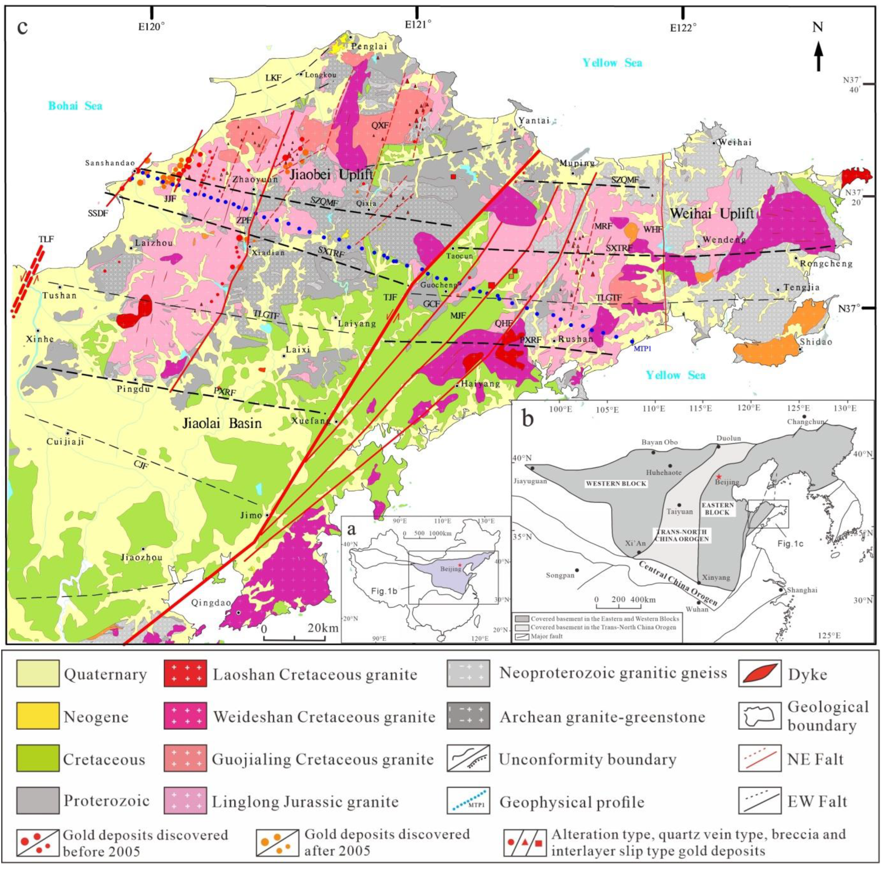
2. Regional and Tectonic Geological Setting

The Jiaodong region is situated at the southeastern margin of the North China Craton, occupying a critical convergence zone between the Paleo-Tethyan and Pacific metallogenic domains. During the Mesozoic, it experienced intense crust–mantle interactions driven by the collision between the Yangtze Block and North China Craton, superimposed with Paleo-Pacific Plate subduction [12]. This tectonic interplay triggered frequent structural deformation and magmatic activities, creating exceptional metallogenic conditions. Bounded by the Tancheng–Lujiang Fault (abbreviated as TLF) to the west (adjacent to the Luxi Terrane), the region comprises three principal tectonic units (Figure 1). The geological framework is primarily composed of Precambrian metamorphic intrusive rocks and metamorphic strata, along with Mesozoic granitoid, volcanic, and continental volcanic-sedimentary sequences.
The Jiaodong region experienced the extensive development of Mesozoic fault structures, where the TLF Zone and Taocun–Jimo Fault (the Shandong segment of the Wulian–Yantai Fault) Zone dominate the regional tectonic framework. The TLF serves as the boundary between the Jiaodong Block and the Luxi Block, while the Wulian–Yantai Fault demarcates the North China Block from the Sulu Ultrahigh-Pressure Metamorphic Belt. Both are strike-slip faults that underwent successive stages of sinistral compressional strike-slip and dextral extensional strike-slip. Centered on the TLF Zone, other faults form a broom-shaped structural pattern that diverges northeastward and converges southwestward. The most prominent faults in the Jiaodong region trend NE-NNE, followed by nearly EW-NEE orientations, while NW-trending faults are generally smaller in scale. The NE-NNE faults, characterized by high density and quantity, act as the primary ore-controlling structures for gold mineralization. Fault types include steeply dipping deep-seated faults, gently dipping listric faults, and steeply dipping minor faults. Gold deposits predominantly occur within gently dipping listric faults and steeply dipping minor faults [1].
The Jiaodong region has undergone multiple magmatic, metamorphic, and tectonic-thermal events spanning from the Archean to Paleoproterozoic cratonization, the collision and amalgamation of the Paleoproterozoic East–West paleocontinents, the subduction and orogeny of the Paleo-Tethys Ocean during the late Paleozoic, and the Triassic continent-continent collision and deep subduction between the North China and South China Block to the far-field effects of the Late Mesozoic Paleo-Pacific Plate subduction. Gold mineralization events are concentrated at 120 ± 2 Ma [14,15,16,17]. The discovered gold deposits in Jiaodong are jointly controlled by basement rock formations and fault structures, predominantly distributed along the intersection zones of regional NE-trending detachment fault systems and near EW-oriented basement structural belts, exhibiting a “NE-trending zonation and EW-trending alignment” pattern [18]. The majority of gold deposits cluster within six NE-oriented structural-gold belts: Sanshandao, Jiaojia, Zhaoyuan–Pingdu, Qixia, Guocheng, and Muping–Rushan [13].

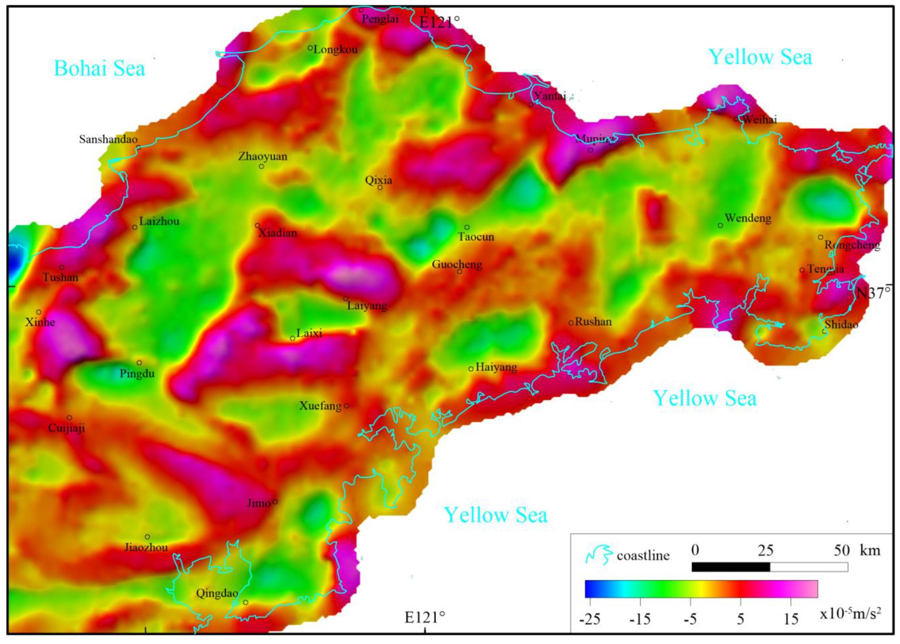
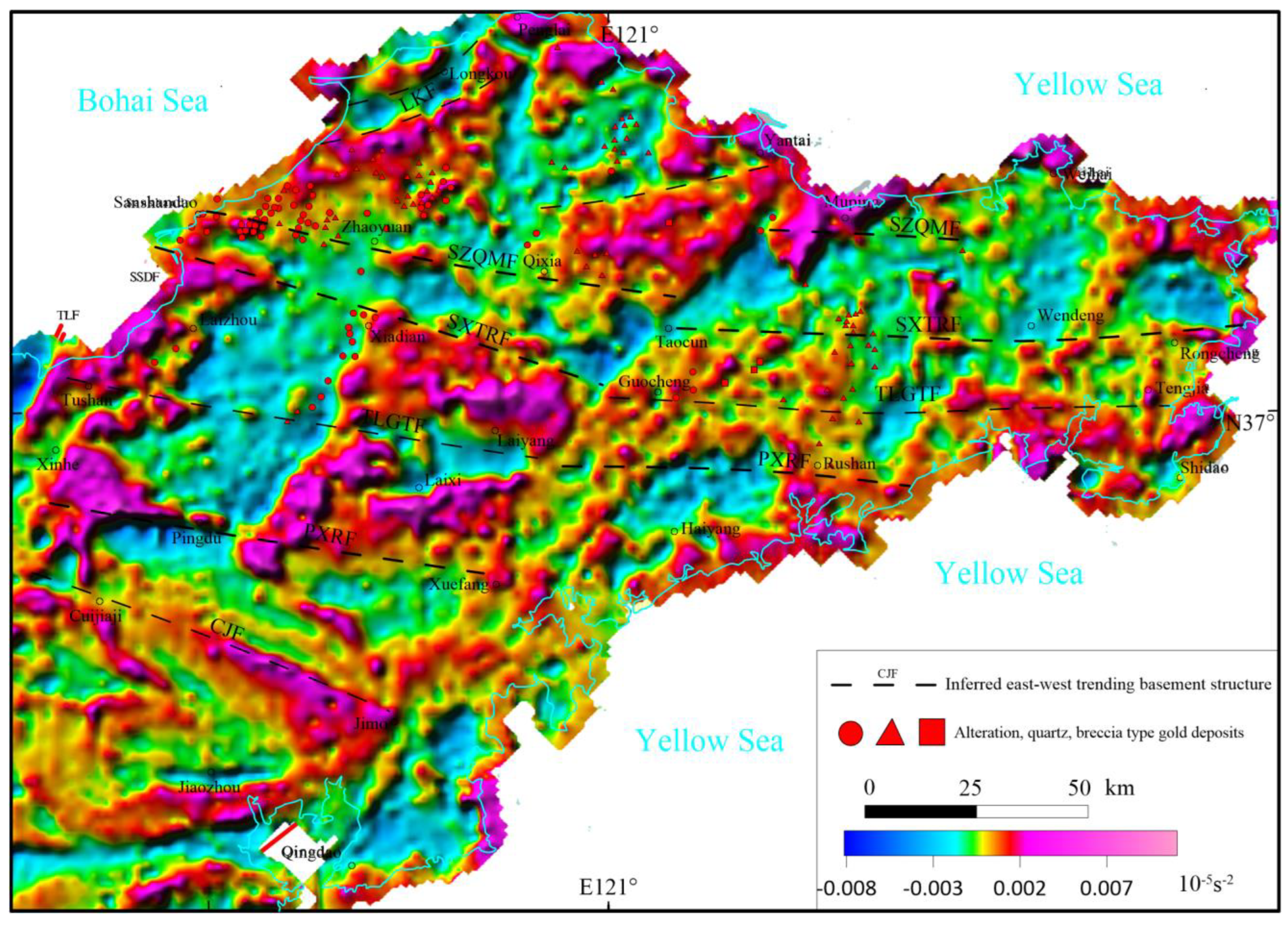
3. Gravity Field Characteristics and Tectonic Response

3.1. Gravity Anomaly Characteristics

The gravity data used in this study were acquired and adopted a 2 km × 2 km measurement grid, with a gravity observation accuracy of ±0.3 × 10⁻⁵ m/s2. The Jiaodong region’s terrestrial gravity data utilized in this study cover a land area spanning 119°30′ E–122°40′ E longitude and 36°00′ N–37°50′ N latitude. Bouguer gravity anomalies were obtained by applying normal gravity field correction, elevation correction, topographic correction, and intermediate layer correction to the field-measured gravity values. The normal gravity values were calculated using the formula recommended by the International Union of Geodesy and Geophysics (IUGG) in 1980, with an average stratum density of 2.67 g/cm3.
Following the application of corrections to the gravity observation data, the Bouguer gravity data were gridded using the Kriging method at a 1 km × 1 km grid size by Oasis montaj (8.0) software. In order to reveal the crustal density structure, the window averaging method (20 km) method was adopted, and the residual Bouguer gravity anomaly in the Jiaodong region was obtained (Figure 2). The gravity anomaly in the Jiaodong region exhibits a north-low–south-high overall trend. In the east–west direction, the anomaly is divided into three distinct zones, forming a “two lows sandwiching one high” pattern, corresponding to the Jiaobei Uplift, Weihai Uplift, and Jiaolai Basin. The Jiaobei Uplift exhibits low Bouguer gravity anomalies, primarily distributed west and north of Xiadian, displaying an anti-”S” shape with a north-south orientation. The Bouguer gravity minimum within the area is located southeast of Laizhou, with a minimum value of −25.77 × 10⁻⁵ m/s2. The western side is dominated by low-density Jurassic Linglong Granite, while the eastern side comprises low-density Jurassic Linglong Granite, Cretaceous Guojialing Granite, Cretaceous Weideshan Granite, and medium-density Archean granite–greenstone mixed rock complexes. The Weihai Uplift exhibits low Bouguer gravity anomalies, primarily distributed east and north of Guocheng, with an elliptical NE-trending distribution. Multiple extremely low-gravity anomalies within the region correspond to Jurassic Linglong Granite and Cretaceous Weideshan Granite, while Paleoproterozoic granitic gneiss and Cretaceous sedimentary basins exhibit moderate gravity anomalies. The gravity minimum within the area is located north of Wendeng, with a minimum value of −25.11 × 10⁻⁵ m/s2. The Jiaolai Basin exhibits a nose-shaped high Bouguer gravity anomaly, sandwiched between the Jiaobei Uplift and Weihai Uplift, primarily reflecting the Cambrian sedimentary crystalline basement. The basin’s interior exhibits an undulating topography, divided into three EW-trending extremely high Bouguer gravity anomaly zones and two relatively lower anomaly zones. The gravity maximum is located south of Laixi, with a maximum value of 37.43 × 10⁻⁵ m/s2, representing the highest gravity anomaly value in the entire study area.

3.2. EW-Trending Basement Structures and Gravity Field Response

Previous studies have shown that basement structures can be inferred using gravity anomalies [19]. The Bouguer gravity anomaly exhibits a distinct EW-trending zonation in the Jiaodong region, characterized by five EW-oriented linear or bead-like high-value anomaly belts, where the value of Bouguer gravity anomalies is greater than 0 × 10−5 m/s2 (Figure 2).
From north to south, these belts are the Sanshandao–Zhaoyuan–Qixia–Muping Belt, Sanshandao–Xiadian–Taocun–Rongcheng Belt, Tushan–Laiyang–Guocheng–Tengjia Belt, Pingdu–Xuefang–Rushan Belt, and Cuijiaji–Jimo Belt. Even after removing the influence of deep mantle material through residual anomaly extraction (Figure 2), the EW-trending anomaly belts remain prominent, reflecting the Cambrian basement structures and rock formation characteristics of the Jiaodong region. During the Triassic period, the collision between the Yangtze and North China Plates led to the northward subduction and compression of the Yangtze Plate. This tectonic event significantly altered the morphology of the Paleoproterozoic crystalline basement, forming EW-trending folds or anticlinal structures, with lithologies dominated by Paleoproterozoic sedimentary crystalline basement. By applying first-order vertical derivative calculation, the geophysical characteristics were significantly enhanced, leading to the identification of five EW-trending basement structural belts (Figure 3). These belts fundamentally control the spatial distribution of gold deposits in the Jiaodong region. Gold deposits in the Jiaodong region are primarily distributed north of two first-order fault zones: the Sanshandao–Zhaoyuan–Qixia–Muping Fault (abbreviated as SZQMF) and the Pingdu–Xuefang–Rushan Fault (abbreviated as PXRF). These deposits exhibit a typical EW-trending distribution pattern.

3.3. NE-Trending Fault Structures and Gravity Field Responses

By calculating the first-order horizontal total derivatives of the Bouguer gravity anomaly, the extreme values of horizontal directional anomaly variations can be extracted, which highlight linear structures. The maxima or minima indicate regions with the greatest intensity of density changes. Figure 4 shows the horizontal gradient map of Bouguer gravity anomalies in the Jiaodong region. Based on the anomaly characteristics, the faults can be classified into three hierarchical levels.
The first-order structures are regional boundary faults spanning the entire area. In the figure, the TLF and TJF demarcate the boundaries between the Luxi–Ludong Block and the North China Plate–Sulu Ultrahigh-Pressure Metamorphic Belt, respectively. These two faults have dominated the tectonic framework of the Jiaodong region since the Late Mesozoic, representing the largest-scale faults in the area with prominent sinistral strike-slip characteristics. The TLF has displaced the Sulu Ultrahigh-Pressure Metamorphic Belt left-laterally by 550 km [20], while the TJF within this region has offset the eastern Sulu Ultrahigh-Pressure metamorphic massif and Weihai Uplift approximately 27 km northeastward.
The second-order structures are secondary faults formed by the retreat and extension of the Pacific Plate. These NE-trending faults (e.g., SSDF, JJF, ZPF, GCF, MJF, QHF, and WHF) exhibit continuity and significant lateral extension on horizontal gradient maps. These faults penetrate depths of 5–10 km and serve as critical mineral-controlling structures in the region. Bounded by the TJF, they are further divided into eastern and western groups. The western group is located in the Jiaobei Uplift, characterized by gently dipping faults that host alteration-type gold mineralization zones. This area forms the core of the Jiaodong gold cluster, with world-class gold metallogenic belts such as Sanshandao, Jiaojia, and Zhaoyuan–Pingdu distributed along these faults. The eastern group consists of a parallel set of high-angle normal faults, including the GCF, MJF, and QHF. These faults are approximately equidistant, spanning a total width of 40–50 km. The southern segment of the fault zone is filled with Cretaceous Laiyang Group sediments, reaching a maximum thickness of over 6000 m [21], and is associated with basin-margin faults.
The third-order structures consist of minor faults and fractures, characterized by steep angles and shallow depths (typically < 5 km). These structures primarily host quartz-vein-type gold deposits, such as the subsidiary faults between the JJF and ZPF, branch fractures of the ZPF, and the MRF.

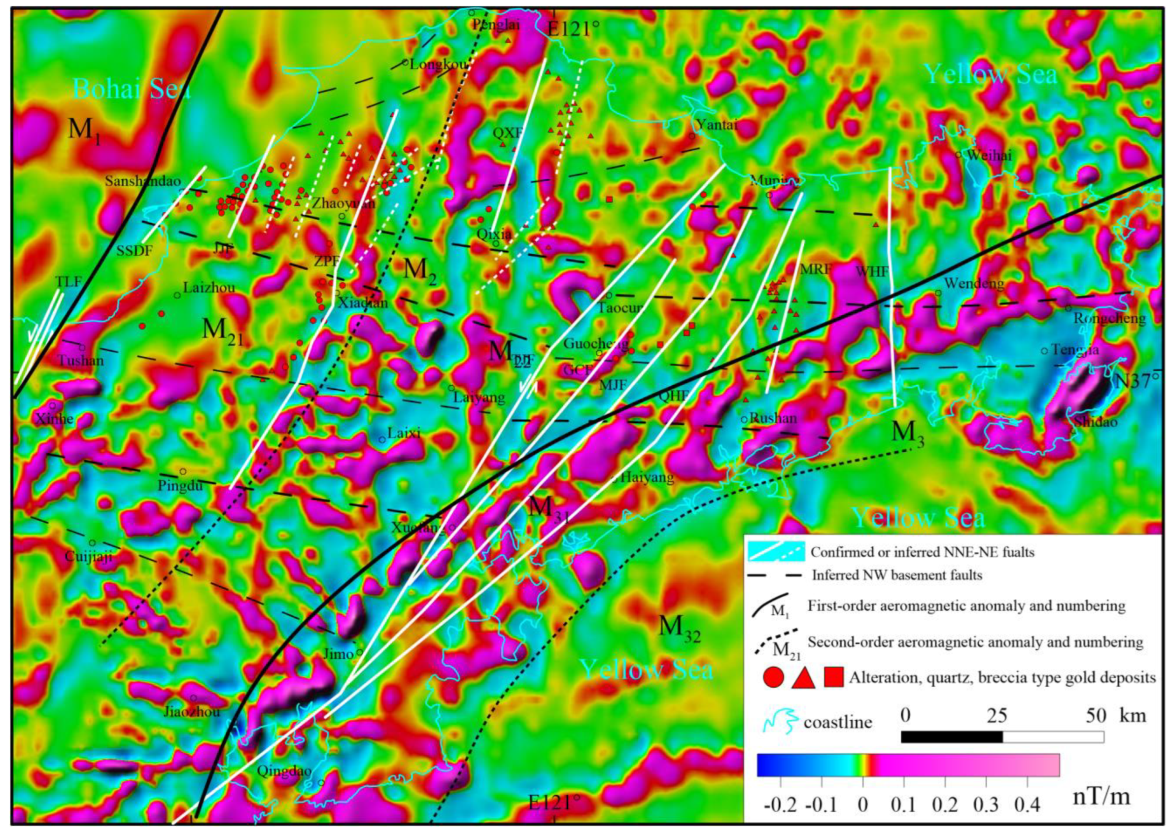
4. Characteristics of Aeromagnetic Anomalies and Tectonic Response

4.1. Characteristics of Aeromagnetic Anomalies

The aeromagnetic data used in this study were derived from the aeromagnetic database submitted to the National Geological Data Center by the National Mineral Resource Potential Assessment project in 2012. The original data were primarily acquired by the China Aero Geophysical Survey and Remote Sensing Center in the early 1980s. The data were collected at a scale of 1:100,000 with a flight altitude of 150 m and a measurement accuracy of ±1.5 nT.
In this study, gridded data were extracted at a grid spacing of 2 km × 2 km, covering an area of 62,350 km2 that includes the land area of the Jiaodong region and the northern and eastern marine areas. Aeromagnetic anomaly data were gridded and mapped using Oasis Montaj (8.0) software, with a grid cell size of 1 km × 1 km via the Kriging method. The regional aeromagnetic anomaly is shown in Figure 5.
The natural geomagnetic field has an inclination angle, causing magnetic bodies to undergo oblique magnetization. Oblique magnetization complicates the shape of magnetic anomalies, leading to phenomena such as positive-negative associated anomalies or positional offsets, which makes it difficult to directly reflect the true morphology of geological bodies. Therefore, aeromagnetic reduction-to-the-pole (RTP) is a critical technique in aeromagnetic data processing. Its core objective is to convert observed obliquely magnetized anomalies into anomalies under vertical magnetization (geomagnetic pole) conditions.
The study area is located between 36° N and 38° N, where aeromagnetic data are affected by oblique magnetization. Prior to interpreting the aeromagnetic anomalies, the raw data were processed using RTP. The magnetic parameters for this RTP processing were derived from the October 1985 International Geomagnetic Reference Field (IGRF) model, with the three geomagnetic parameters being a declination of −5.9°, an inclination of 52.1°, and a total magnetic field intensity of 51,000 nT. Figure 6 shows the aeromagnetic anomaly map after RTP, revealing that the magnetized anomalies exhibit more convergent and regular patterns with concentrated extreme values.
The aeromagnetic reduction-to-the-Pole anomaly of the Jiaodong region and its periphery exhibit an NNE-NE-NEE-trending zonation from west to east, described as “high–moderate–high” in intensity and “coherent–chaotic–coherent” in structural continuity. The anomalies display a broom-shaped pattern, diverging northeastward and converging southwestward (Figure 6). Three distinct zones are identified: the M1 zone, characterized by moderate aeromagnetic anomalies with relatively coherent patterns, is primarily located in the offshore area north of Xinhe Town. This zone reflects the North China Craton basement and is situated west of the TLF Zone.
The M2 zone exhibits moderate aeromagnetic anomalies with alternating high–low intensities and scattered distribution. It encompasses the Jiaobei Uplift and Jiaolai Basin between the North China Plate and the Sulu Ultrahigh-Pressure Metamorphic Belt. This area is characterized by widespread exposures of Precambrian metamorphic mafic-intermediate rocks, Mesozoic acidic granites, and Proterozoic strata. The chaotic magnetic anomalies reflect intense Mesozoic magmatism, making this zone the primary gold metallogenic belt in Jiaodong. It is further divided into M21 and M22 subzones along the ZPF. The northern segment of the M21 zone encompasses the Bohai Sea and coastal areas of northwestern Jiaodong (e.g., Sanshandao and Jiaojia), characterized by negative magnetic anomalies. The central segment is dominated by Jurassic Linglong granite outcrops, characterized by negative-to-weak magnetic anomalies, and hosts the supergiant Linglong gold metallogenic cluster. The southern segment corresponds to the Jiaolai Basin, where magnetic anomalies primarily reflect basement structures and magmatic intrusions, exhibiting a combination of moderate-to-high magnetic anomalies intermingled with negative anomalies. The M22 zone is located at the convergence belt between the North China Craton and the Sulu Ultrahigh-Pressure Metamorphic Terrane. The western segment exhibits high-amplitude NNE-trending magnetic anomalies, with the northern part corresponding to Cretaceous Weideshan granites and the southern part reflecting the basement uplift and intra-basin magmatic intrusions of the Jiaolai Basin. The eastern segment, characterized by lower-amplitude, stable magnetic fields, corresponds to the Weihai Uplift. The plate-boundary fault, TJF, is poorly imaged in the aeromagnetic anomalies of the M22 zone, likely due to intense Mesozoic magmatic activity. Shallow emplacement of magmatic and intrusive rocks has generated chaotic magnetic signatures, obscuring structural patterns.
The M3 zone is characterized by high-amplitude aeromagnetic anomalies, fan-shaped across the southeastern Jiaodong Peninsula and the Yellow Sea. The prominent strip-shaped ultra-high magnetic anomaly subzone (M31) reflects the Sulu Ultrahigh-Pressure Metamorphic Belt, arcing along the coast from Qingdao–Jimo–Haiyang–Rushan–Wendeng, with a length of ~277 km and width of 25–30 km. The anomaly axis trends nearly N–S near Qingdao, gradually shifts to NE towards the north, and turns E–W near Wendeng and Rongcheng, spanning ~90° in orientation. The southeastern subzone (M32) in the Yellow Sea exhibits moderate-to-high magnetic anomalies, corresponding to the Yangtze Block basement, with gentle internal variations. Notably, EW-trending strip-shaped anomalies are observed east of Qingdao, extending eastward to ~122° E.

4.2. Aeromagnetic Response of Faults and Intrusions

The Jiaodong region experienced intense Mesozoic magmatic activity, with extensive shallow magmatic and intrusive rocks, resulting in chaotic aeromagnetic anomalies with unclear patterns. Vertical first-derivative calculations (Figure 7) revealed significant internal variations in the M2 zone, consistent with reduced-to-pole aeromagnetic anomalies, reflecting multiple phases of complex large-scale magmatism. In addition to high-amplitude anomalies from the Jiaolai Basin’s basement and intrusions, the Cretaceous Weideshan-type granites exposed in the Jiaobei Uplift, Weihai Uplift, and areas such as Qixia-Penglai, the Taocun Fault zone, and the southeastern coast exhibit positive magnetic anomalies (Figure 6).

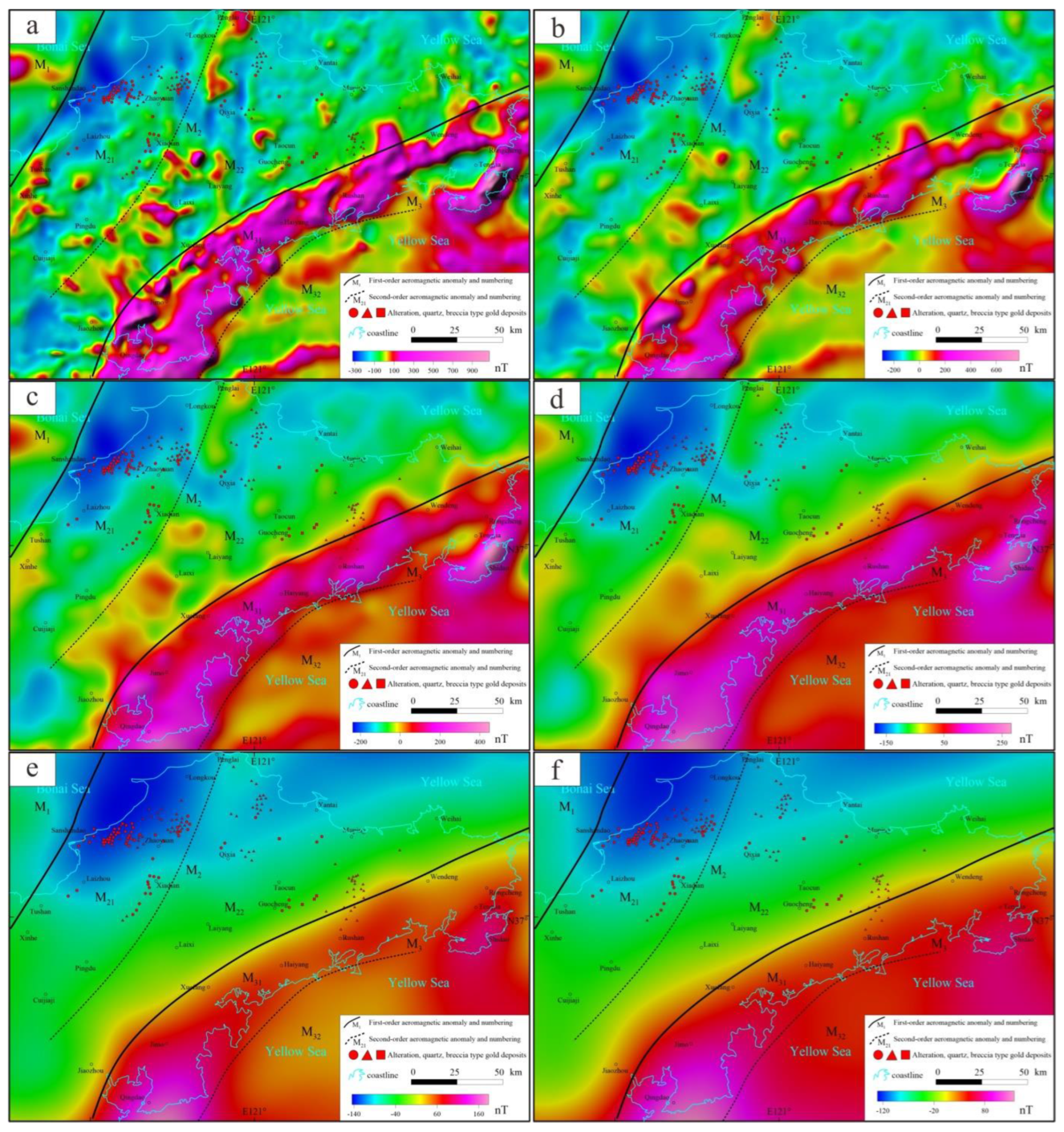
4.3. Characteristics of Deep-Seated Aeromagnetic Anomalies and Ore Deposit Distribution

Previous studies have shown that deep crustal faults can be inferred using aeromagnetic anomalies [12]. By upward continuation to different heights (Figure 8), deep-seated anomalies are enhanced, revealing the block-like magnetic distribution from northwest to southeast in the Jiaodong region. This reflects traces of the Pacific collision, where the Yangtze Plate and the Sulu Ultrahigh-Pressure Terrane subducted northwestward beneath the North China Plate. On NE-trending aeromagnetic anomalies, northward-convex anomalies are superimposed, evident at 10 km upward continuation and persisting at 30 km depth (e.g., in Laixi–Laiyang and Yantai–Muping areas). These features result from the Yangtze–North China collision modified by later Pacific Plate subduction (compression and rollback), triggering ultrahigh-pressure metamorphism, basement melting, mantle upwelling, and reorientation of magnetic fabrics, particularly forming NE-trending high-magnetic-anomaly belts at collision boundaries.
As previously discussed, the crystalline basement of the Jiaolai Basin and the Sulu Ultrahigh-Pressure Metamorphic Belt in the Jiaodong region exhibit high magnetic characteristics, while Mesozoic granites are weakly magnetic or non-magnetic. According to previous studies, gold deposits in Jiaodong are primarily associated with Mesozoic granites. Alteration-type gold deposits predominantly occur in fractured zones of Mesozoic granitic plutons, with fault footwalls often composed of ancient metamorphic rocks or Precambrian strata. Quartz-vein-type gold deposits are mainly distributed in secondary fractures or rock fissures of major faults. Therefore, linear negative-to-weak magnetic anomaly zones with a significant spatial scale are the most favorable metallogenic targets. For example, super-large gold deposits such as Sanshandao, Jiaojia, Xincheng, and Linglong are located within NE-trending banded negative or weak magnetic anomaly zones. In weak-to-moderate magnetic anomaly areas with linear features or surface exposures of Mesozoic granites (e.g., northern QXF and the Rushan Fault), quartz-vein-type gold deposits are common. In contrast, regions with intact geological blocks (e.g., the Jiaolai Basin), areas south of the Sulu Ultrahigh-Pressure Metamorphic Belt, and zones dominated by post-mineralization granites (e.g., Weideshan and Laoshan granites) lack prospecting potential. These areas typically display coherent positive magnetic anomalies (Figure 6).

5. Magnetotelluric Characteristics and Tectonic Implications

5.1. Data Acquisition and Processing

In 2016, we deployed a broadband MT measurement profile in the Jiaodong region (Figure 1). The profile starts from the coast of Sanshandao Town (37°23′05.6″ N, 119°56′19.6″ E) in the west and extends southeast to the coast of Rushan City (36°54′32.6″ N, 121°48′13.3″ E), with an azimuth of 108°. A total of 51 measurement points were arranged at 3.5 km intervals along the 170 km-long profile, with an average observation duration exceeding 40 h per station.
Data processing includes Fast Fourier Transform (FFT), impedance and phase calculation, power spectrum editing, and denoising, ultimately yielding frequency-domain data in the range of 100–0.001 Hz [22]. Based on the definition of skin depth, the detection depth of MT data in ore-concentrated areas exceeds 60 km (with an average apparent resistivity > 200 Ω·m). To ensure data quality, manual inspection is performed on automatically denoised data to verify noise removal effectiveness, including deleting discontinuous points in apparent resistivity and impedance phase-frequency curves or restoring erroneously removed data.
Based on the nonlinear conjugate gradient (NLCG) 3D inversion algorithm [23] and the EMinv 1.0 software [24,25], we integrated 81 broadband magnetotelluric (MT) sites from two 2017–2018 survey lines northeast of the main profile and 32 additional MT sites collected by Zhang et al. (2018) to improve the 3D inversion results [11,26]. The inversion utilized frequency-domain data ranging from 0.001 to 100 Hz to construct a 3D crustal electrical resistivity model. Full-tensor impedance data were employed, with error limits set at 10% for off-diagonal components and 20% for diagonal elements. The initial model was a homogeneous half-space with a resistivity of 100 Ω·m. After iterative testing of initial models, inversion parameters, and input data, combined with prior geological constraints, the final data misfit decreased from 13.57 to 1.24, meeting inversion convergence criteria.

5.2. Deep Electrical Structure

Based on the 3D inversion of MT data in the Jiaodong region, this study established a deep 3D electrical resistivity model of the Jiaodong Peninsula. We focused on the inversion results along the 2016 Sanshandao-Rushan profile (MPT1 in Figure 1). The MT inversion (Figure 9) reveals a vertically layered electrical structure: (1) shallow (0–5 km) scattered low-resistivity zones corresponding to fault fracture zones and sedimentary basins; (2) middle (0–20 km) high-resistivity layers dominated by granite, metamorphic rocks, and Paleoproterozoic crystalline basement; and (3) deep (>30 km) conductive layers beneath the Moho. Laterally, the ZPF and TJF exhibit moderate-to-low resistivity, while the Jiaolai Basin shows similar characteristics. The western side of the TJF (Archaean Metamorphic Terrane) and its eastern side (Sulu Ultrahigh-Pressure Metamorphic Belt) display uniformly high resistivity.
The JJF, ZPF, and TJF are all characterized by steeply dipping low-resistivity zones (~5 km wide) penetrating from the upper-middle crust to the Moho. The JJF exhibits a shallow-dipping upper section and a steeper lower section, dipping northwestward and extending beyond 5 km depth, where it intersects the SSDF at ~5 km depth, forming a “Y”-shaped configuration with the deep low-resistivity zone. Similarly, the ZPF converges with the deep conductive zone at ~5 km depth, creating a comparable “Y”-shaped pattern. West of the TJF, a vertical low-resistivity zone exists below 10 km depth, splitting into two shallow branches dipping east and west, collectively forming a “Y”-shaped structure with the deep conductive zone. These three low-resistivity zones are interpreted as deep-seated faults or magmatic channels extending into the lower crust, connecting the upper crust to the lithospheric mantle. Ore-forming materials migrated upward along these faults or magmatic channels. The rollback and extension of the Pacific Plate during the Mesozoic induced shallow secondary extensional faults with low dip angles, providing pathways and reservoirs for mineralization.
To the west of the TJF, a SE-dipping fault is identified at depth. The Jiaobei Uplift on the western side of the fault shows significant uplift of low-resistivity strata at ~30 km depth. This is interpreted as a result of Pacific Plate collision and extension, leading to mantle upwelling, lithospheric thinning, and Moho uplift on the western side, while the eastern side exhibits lithospheric subsidence. Partial melting of the lower crust on the western side facilitates mixing with mantle-derived materials. Under gravitational forces, Au-rich ore-forming fluids migrate upward through the thinned lithosphere. These fluids either ascend along shallow faults, mix with meteoric water, and condense to form low-grade fractured alteration-type gold deposits, or directly fill rock fractures to generate high-grade quartz vein-type gold deposits. East of the TJF, the rollback and extension of the Pacific Plate formed the Jiaolai extensional basin. Within the basin, a series of high-angle detachment faults (e.g., GCF, MJF, and HYF) developed. Beneath the basin, the Sulu Ultrahigh-Pressure Metamorphic Belt thrusts northwestward into the mid-upper crust, exhibiting high-resistivity characteristics.

6. Discussion

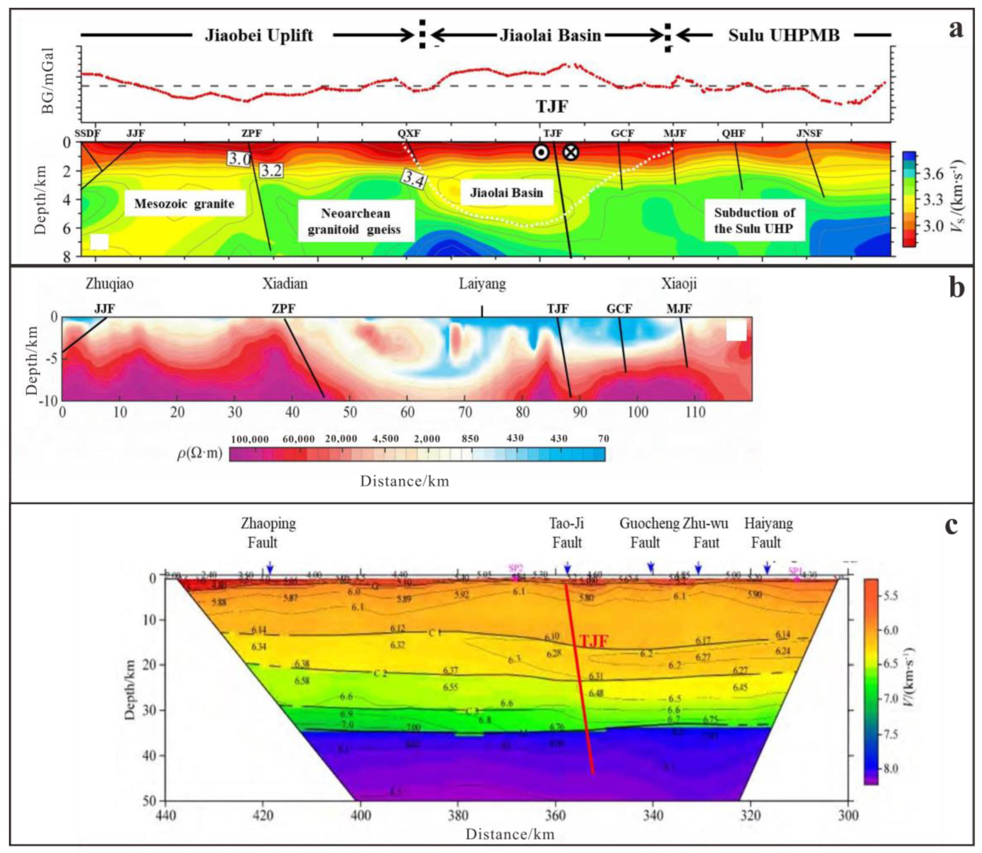
6.1. North China Craton–Sulu Ultrahigh-Pressure Metamorphic Belt Boundary

The boundary between the North China Craton and the Sulu Ultrahigh-Pressure Metamorphic Belt is regarded as the collisional suture zone between the Yangtze and North China Block in the Jiaodong region, but its precise location remains debated. Cao (1990) proposed the Wulian–Rongcheng Fault as the northern boundary of the Jiaonan Terrane [27]. Lin (1993) argued that the boundary lies along the Taocun–Shanxiangjia Fault [28]. Wang (1994) proposed that the tectonic boundary is situated proximal to the Mishan Fault [29]. Gu et al. (1996) concluded that the true divide between the North China Platform and the Jiaonan Uplift is located north of the Wulian–Rongcheng Fault [30]. Zhai (1999) hypothesized that the boundary is not a simple fault but rather a Kunyu Mountain Boundary Complex Belt between the Muping and Mishan Faults, characterized by composite granitic plutons, dikes, metamorphic lenses, and tectonic slices [31]. Wang et al. (2002) discovered eclogites and mafic-intermediate dike swarms in Yulindian. Combined with other evidence, they proposed that the northeastern segment of the Jiaonan Orogenic Belt’s northern boundary lies between the Taocun Fault and the MJF, roughly along the western side of the MJF [32].
By calculating the vertical first derivative of the Bouguer gravity anomaly, distinct differences in gravity anomalies were observed across the TJF (Figure 10a). The western block exhibits integrated gravity anomalies with higher amplitudes, while the eastern region shows scattered, low-amplitude anomalies. The TJF displays strong continuity, extending northward to the offshore area south of Yantai and connecting southward to the Wulian Fault near Jimo. In contrast, the GCF, MJF, and QHF are located within zones of minimal gravity amplitude variation. These three faults share comparable anomaly amplitudes, gentle lateral gradients, and poor continuity. Upward continuation analysis (Figure 5) reveals no deep-seated signatures for these faults, indicating that their shallow crustal origins as Mesozoic extensional faults formed during the retreat of the Paleo-Pacific Plate.
The Bouguer gravity anomaly reveals that the TJF demarcates two blocks with distinct strike-slip characteristics on its eastern and western sides. High-gravity and high-magnetic anomalies on the eastern side of the fault are displaced approximately 27 km northeastward (Figure 10b,c). Surface exposures of the Weideshan Granite and Cretaceous sedimentary strata on the eastern side also exhibit a 27 km NE displacement (Figure 10d). The upward continuation of gravity data (Figure 5) confirms that the TJF persists at depth, indicating its role as a crustal-scale tectonic boundary fault. These observations demonstrate that the TJF is a deep-seated strike-slip fault, consistent with the Triassic subduction-collision event between the Yangtze and North China plates, which triggered large-scale lateral displacement.
Yu, G. P., et al. (2020) obtained the upper crustal S—wave velocity structure at 0–8 km depth in the Jiaodong region using short—period dense seismic array ambient noise tomography [33]. The S-wave velocity structure derived from short-period dense array ambient noise tomography indicates that the locations of the ZPF and TJF align with the gravity anomaly boundaries revealed in this study (Figure 11a). The Jiaodong region exhibits lateral segmentation in velocity structure, with a marked contrast in S-wave velocities across the TJF. West of the TJF lies Cretaceous sedimentary strata with lower S-wave velocities, while east of the fault is the Sulu Ultrahigh-Pressure Metamorphic Belt, characterized by significantly higher velocities. A high-velocity body exists in the deep eastern part of the fault zone, primarily caused by Pacific Plate subduction and the westward underthrusting of ultrahigh-pressure metamorphic rocks beneath the basin (delineated by the white dashed lines in Figure 9 and Figure 11a). Therefore, the TJF exhibits both strike-slip characteristics inherited from the collision between the Yangtze and North China Plates and compressional-extensional features associated with the subduction retreat of the Pacific Plate [33].
He et al. (2022) [10] proposed the MJF Zone based on a 120-km-long MT profile from Jinchang Town (Laizhou City) to Ershilidian Town (Haiyang City), grouping faults such as the Taocun, Guocheng, and Zhuwu (developed within Mesozoic basins) under this unified tectonic framework [10]. However, their study did not explicitly define the specific boundary between the Jiaobei Terrane and the Sulu Terrane. This paper argues that the TJF can be identified as the deepest fault along the MT profile, based on the following evidence from the MT inversion cross-section (Figure 11b): the TJF exhibits a distinct downward bending of the resistivity phase axis, a vertically extensive low-resistivity zone, and a sharp resistivity contrast between its eastern and western blocks, marking it as the deepest-penetrating fault along the entire profile. In contrast, the GCF and MJF on the eastern side exhibit weak geoelectric responses in the MT inversion profile, with shallow penetration depths. These are interpreted as high-angle extensional faults formed during the retreat of the Paleo-Pacific Plate, primarily controlling intra-basin stretching [10].
Pan et al. (2015) [34] conducted active-source deep seismic wide-angle reflection/refraction profiling in the Jiaodong Peninsula (Figure 11c). Their findings revealed that the Zhuwu Fault (referred to as the MJF in this study) and GCF exhibit significant undulations in velocity contours across the G interface, while their structural variations above the C1 interface are relatively uniform. These faults penetrate the basement but terminate above the C1 interface, consistent with results from natural seismicity and MT surveys. The crustal velocity structure on both sides of the TJF exhibits lateral and vertical heterogeneity from shallow to deep levels: The G interface shows significant variation, deepening eastward. From the surface to the Moho (M interface), the velocity structure differs markedly between the eastern (lower velocities) and western (higher velocities) sides, reflecting distinct block characteristics. Near the fault zone, the C1, C2, and M interfaces display localized uplift or depression, while the C3 interface is only present in the western segment. These observations suggest that the TJF is a deep-crustal fault and represents the deep-seated manifestation of the collisional boundary between North China and the Yangtze Block [34].
The TJF is predominantly buried beneath the JLB, with only its northern segment exposed at the surface. Previous surface geological surveys struggled to trace its southern extension, leading to the consensus that it terminates near Jiangtong Town. However, integrated geophysical surveys (e.g., seismic reflection, MT, and gravity data) now reveal that the TJF penetrates the entire lithospheric crust and exhibits prominent strike-slip characteristics. The fault’s eastern block has been displaced approximately 27 km northeastward, marking it as the tectonic boundary between the North China Craton and the Sulu Ultrahigh-Pressure Metamorphic Belt.

6.2. Jiaodong Gold Metallogenic System and Exploration Directions

Research by Zhu et al. (2015) [35] indicates that super-large and large gold deposits are predominantly concentrated in the Jiaobei Uplift (western Jiaodong), while medium- to small-scale quartz vein-type gold deposits are mainly distributed near the TJF (Figure 12) [35]. East of the TJF, gold mineralization is scarce. Along the margins of the JLB, gold deposits such as altered rock-type and conglomerate-type are found along basin-edge and basement faults:
(1)
Source of ore-forming materials: During the Triassic, the Yangtze Block subducted beneath the North China Craton to depths of tens to hundreds of kilometers, accompanied by orogenesis that formed the Jiaobei Uplift. In the Jurassic, the retreat of the Pacific Plate induced mantle upwelling, leading to the detachment and melting of the subducted lithospheric lower crust. The melted lower crust mixed with the upper mantle, providing metallogenic materials for the Jiaodong gold cluster. Therefore, the TJF serves as a critical tectonic boundary, the Jiaobei Uplift represents the leading edge of the Yangtze Block subduction-collision, while the Sulu Ultrahigh-Pressure Metamorphic Belt marks the collisional suture zone. The region west of the TJF—specifically the Jiaobei Uplift—hosts favorable conditions for mineralization, whereas the area east of the fault (Sulu Ultrahigh-Pressure Belt) exhibits relatively limited ore-forming potential. Furthermore, it is inferred that the collision front is bounded by the TLF, the rear boundary by the TJF, and the southern margin by the EW-trending basement structural belt along the northern edge of the JLB (Figure 3). The northern side of the Jiaobei Uplift remains unclosed, with aeromagnetic anomalies indicating that the ZPF and TJF extend northward into the Bohai Sea, suggesting potential mineralization in offshore areas.
(2)
Ore-forming migration pathways: The NE-trending faults in the Jiaodong region can be broadly categorized into three types: Category 1: Deep Major Strike-Slip Faults (e.g., TLF, TJF), which act as boundary faults between tectonic plates or geological units, exerting fundamental control over the regional distribution of gold deposits in the Jiaodong region. Category 2: Extensional Low-Angle Detachment Faults, which are predominantly distributed in the Jiaobei Uplift and exhibit a characteristic geometry with steep upper segments and gentle lower segments. As typical extensional structures, they extend to depths exceeding 4 km and include major ore-controlling faults such as SSDF, JJF, ZPF, QXF, and MRF. Notably, the SSDF, JJF, and ZPF zones collectively host over 4000 tons of proven gold resources [1]. Existing studies indicate that the majority of Jiaodong gold deposits formed at depths of 5–10 km, followed by regional uplift and approximately 5 km of erosion during post-mineralization stages [1]. Consequently, the ore-hosting fractures associated with gold enrichment originated at depths exceeding 10 km, representing basement-scale structures. Crust–mantle hybrid hydrothermal fluids enriched in ore-forming elements ascended through magmatic conduits or boundary faults (e.g., the TLF) during mantle upwelling. These fluids migrated into shallow crustal structures such as extensional faults, where they cooled and precipitated gold through pressure reduction and sulfide-driven metal scavenging [13]. Category 3: Steeply Dipping Linear Faults, which are primarily distributed near the eastern side of the TJF and exhibit nearly equidistant parallel alignment with the TJF. Examples include the GCF, Muping fault, and HYF. They formed during the retreat of the Pacific Plate, with a burial depth of less than 5 km and steep angles (>60°). Due to their limited depth and unfavorable structural geometry, mineralization-enriched materials struggle to accumulate, rendering these faults generally barren of ore deposits.
The gold mineralization in the Jiaodong region is attributed to mantle upwelling triggered by the retreat and subduction of the Pacific Plate. The NE-trending deep fault systems, exemplified by the ZPF, serve as primary channels for ore-forming hydrothermal fluid migration. Geophysical surveys (magnetotelluric and seismic data) have identified thermal upwelling zones beneath the ZPF and its western flank. The ore-forming materials originated from the crustal melting and mantle hybridization induced by the subduction of the South China Block beneath the North China Block. The leading edge of this subduction is located in the Sanshandao–Linglong area, with a southward decrease in both gold enrichment and mineralization intensity. The Jiaodong gold deposits are jointly controlled by EW-trending basement structures and NE-trending faults. The EW-trending structures, formed during the collision between the Yangtze and North China Block, dominate the east–west orientation of gold mineralization. The next phase of mineral exploration should focus on the complex zone where the subduction front of the South China Block intersects with the Pacific Plate, with priority given to the northwestern Jiaodong region (Figure 13). In recent years, a giant gold deposit has been discovered in the northern offshore area of the Sanshandao region, which connects to the deep southern land area to form a supergiant deposit exceeding 1000 tons of gold reserves. The main ore bodies are concentrated in the northern offshore zone, with significant exploration potential. Geophysical studies of gravity and magnetic fields support this conclusion: the Bouguer gravity anomaly is moderate and located within a gradient transition zone, while aeromagnetic data reveal an NE-trending low anomaly extending from the Sanshandao region. The gold exploration potential in the Jiaodong region is concentrated in the northwestern area, specifically north of the SZQMF and west of the TJF, with a primary focus on the Sanshandao–Longkou area and its northern offshore zones. The Penglai–Qixia area (approximately 225 km2 of uplifted terrain) exhibits extremely low Bouguer gravity anomalies and high magnetic anomalies, which are attributed to the Weideshan-type granite formed after the gold mineralization period. This region shows limited prospecting potential (Figure 13).

7. Conclusions

(1)
The Bouguer gravity anomalies in the Jiaodong region exhibit an overall pattern of lower values in the north and higher values in the south, with block-like structures segmented in east–west directions and interspersed with belt-shaped anomalies. This reflects the tectonic framework of “two uplifts sandwiching a basin” (Jiaobei Uplift and Weihai Uplift flanking the JLB) and the EW-trending basement folds or rock formations, which collectively control the primary distribution pattern of gold deposits in Jiaodong.
(2)
The aeromagnetic anomalies in the Jiaodong region exhibit an eastward trend characterized by increasing anomaly values (from moderate to high) and transitioning from chaotic to coherent distribution patterns, reflecting intense Mesozoic magmatism and traces of plate collision. These anomalies further indicate that the ZPF and TJF extend northward into the offshore areas.
(3)
Magnetotelluric Sounding has revealed deep-seated fault systems and crustal characteristics associated with mineralization in the Jiaodong region. Notably, electrical signatures of lithospheric thinning, mantle upwelling, and Moho uplift have been identified in the Jiaobei Uplift, bounded by the TJF. In addition, three Y-shaped fault systems or magmatic channels of varying scales, penetrating the lower crust and lithosphere, have been identified, providing migration pathways and storage spaces for the enrichment of gold mineralization.
(4)
The TJF penetrates the entire lithospheric crust and exhibits prominent strike-slip characteristics. The geological units east of the fault have been displaced ~27 km northeastward, influenced by the retreat of the Pacific Plate and subsequent tectonic modifications. It is inferred that the northern segment of the TJF underwent clockwise extensional rotation during later stages. This fault serves as the tectonic boundary between the North China Craton and the Sulu Ultrahigh-Pressure Metamorphic Belt.
(5)
The next phase of gold exploration in the Jiaodong region should focus on the northwestern study area, specifically north of the SZQMF and west of the TJF. The Sanshandao-Longkou zone and its northern offshore areas exhibit immense prospecting potential.

Author Contributions

Conceptualization, H.K. and J.Y.; methodology, H.K. and J.Y.; software, K.Z. and J.Y.; validation, K.Z. and J.L.; formal analysis, J.Y. and C.F.; investigation, W.T. and C.F.; data curation, H.K., W.T., C.F. and G.Z.; writing—original draft preparation, H.K. and J.Y.; writing—review and editing, J.Y., H.K. and Y.Y.; funding acquisition, J.Y. All authors have read and agreed to the published version of the manuscript.

Funding

This work was granted by the National Key Research and Development Program of China under Grant 2023YFC2906904 and in part by the Key Research and Development Project funded by the Basic Scientific Research Business Expenses of the Central-level Research Institutes Grant JKYZD202303.

Data Availability Statement

For data acquisition, please contact the first author or the corresponding author.

Acknowledgments

We would like to express our gratitude to the three reviewers for their insightful and constructive feedback, which significantly improved the quality of this paper.

Conflicts of Interest

The authors declare that they have no known competing financial interests or personal relationships that could have appeared to influence the work reported in this paper.

References

  1. Song, M.C.; Wang, H.J.; Liu, H.B.; He, C.Y.; Wei, Y.T.; Li, J.; Cao, J.J.; Niu, S.Y.; Tian, J.X.; Li, X.Z.; et al. Deep characteristics of ore−controlling faults in Jiaoxibei gold deposits and its implications for prospecting: Evidence from geophysical surveys. Geol. China 2024, 51, 1–16. (In Chinese) [Google Scholar] [CrossRef]
  2. Goldfarb, R.J.; Pitcairn, I. Orogenic gold: Is a genetic association with magmatism realistie? Miner. Depos. 2023, 58, 5–35. [Google Scholar] [CrossRef]
  3. Song, M.C.; Cui, S.X.; Zhou, M.L.; Jiang, H.L.; Yuan, W.H.; Wei, X.F.; Lü, G.X. The Deep Oversize Gold Deposit in the Jiaojia Field, Shandong Province and Its Enlightenment for the Jiaojia gold type. Acta Geol. Sin. 2010, 84, 1349–1358. (In Chinese) [Google Scholar]
  4. Zhai, M.G.; Fan, H.R.; Yang, J.H.; Miao, L.C. Large-Scale Cluster of Gold Deposits in East Shandong: Anorogenic Metallogenesis. Earth Sci. Front. 2004, 11, 85–98. (In Chinese) [Google Scholar]
  5. Deng, J.; Wang, Q.F.; Zhang, L.; Xue, S.C.; Liu, X.F.; Yang, L.; Yang, L.Q.; Qiu, K.F.; Liang, Y.Y. Metallogenetic model of Jiaodong-type gold deposits, eastern China. Sci. China Earth Sci. 2023, 66, 2287–2310. [Google Scholar] [CrossRef]
  6. Li, L.; Santosh, M.; Li, S.R. The ‘Jiaodong type’ gold deposits: Characteristics, origin and prospecting. Ore Geol. Rev. 2015, 65, 589–611. [Google Scholar] [CrossRef]
  7. Groves, D.I.; Santonsh, M. The giant Jiaodong gold province: The key to a unified model for ogenic gold deposits? Geosci. Front. 2016, 7, 409–417. [Google Scholar] [CrossRef]
  8. Wang, H.J.; Tian, H.J.; He, C.Y.; Liu, G.D. An analysis of the effect of multiple geophysical prospecting methods in the deep exploration of the Jiaoxibei (northwest Shandong) gold ore concentration area. Geophys. Geochem. Explor. 2020, 44, 1053–1058. (In Chinese) [Google Scholar] [CrossRef]
  9. Chen, D.L.; Wang, R.S.; He, C.Y.; Wang, X.; Yin, Z.K.; Yu, J.B. Application of integrated geophysical exploration in deep spatial structures: A case study of Jiaodong gold ore concentration area. Geophys. Geochem. Explor. 2022, 46, 70–77. (In Chinese) [Google Scholar] [CrossRef]
  10. He, C.Y.; Yao, Z.; Guo, G.Q.; Liu, H.B.; Song, M.C.; Li, S.Y.; Chen, D.L.; Liu, W. Deep structural features of the Jiaobei terrane of Jiaodong and the North Sulu orogenic belt: The inspiration from deep exploration of the geophysics. Prog. Geophys. 2022, 37, 1392–1404. (In Chinese) [Google Scholar] [CrossRef]
  11. Zhang, K.; Lü, Q.T.; Yan, J.Y.; Hu, H.; Fu, G.M.; Shao, L.S. Crustal structure beneath the Jiaodong Penisula, North China, revealed with a 3D inversion model of magnetotelluric data. J. Geophys. Eng. 2018, 15, 2442–2454. [Google Scholar] [CrossRef]
  12. Teng, X.J.; Fu, C.; Li, J.J.; Li, Z.D.; Tang, W.L. Characteristics and Geological Implications of the Ophiolite Belts in the Sino-Mongolian Border Region. North China Geol. 2024, 47, 1–13. (In Chinese) [Google Scholar] [CrossRef]
  13. Yang, L.Q.; Deng, J.; Zhang, L.; Yang, W.; Xie, D.; Wang, L.; Qiu, K.F.; Li, D.P. Jiaodong-type gold deposit. Acta Petrol. Sin. 2024, 40, 1691–1711. [Google Scholar] [CrossRef]
  14. Li, S.Z.; Hao, D.F.; Han, Z.Z.; Zhao, G.C.; Sun, M. Paleoproterozoic Deep Processes and Tectono-thermal Evolution in Jiao-Liao Massif. Acta Geol. Sin. 2003, 77, 328–340. (In Chinese) [Google Scholar]
  15. Zheng, Y.F.; Xiao, W.J.; Zhao, G.C. Introduction to tectonics of China. Gondwana Res. 2013, 23, 1189–1206. [Google Scholar] [CrossRef]
  16. Zhao, R.; Wang, Q.F.; Deng, J.; Santosh, M.; Liu, X.F.; Liang, Y.Y.; Cheng, H.Y. Characterizing episodic orogenesis and agmatism in eastern China based on detrital zircon from the Jiaolai Basin. Am. J. Sci. 2019, 319, 500–525. [Google Scholar] [CrossRef]
  17. Zhai, M.G.; Zhao, L.; Zhu, X.Y.; Jiao, S.J.; Zhou, Y.Y.; Zhou, L.G. Review and overview for the frontier hotspot: Early continents and start of plate tectonics. Acta Petrol. Sin. 2020, 36, 2249–2275. (In Chinese) [Google Scholar] [CrossRef]
  18. Yang, L.Q.; Deng, J.; Wang, Z.L.; Zhang, L.; Guo, L.N.; Song, M.C.; Zheng, X.L. Mesozoic gold metallogenic system of the Jiaodong gold province, eastern China. Acta Petrol. 2014, 30, 2447–2467. [Google Scholar]
  19. Yu, R.; Si, Q.; Peng, S. Comprehensive exploration techniques and Practices for Sandstone type uranium deposit: A case study of BYH uranium deposit in Erlian Basin. North China Geol. 2024, 47, 23–35. [Google Scholar]
  20. Zhang, Y.Q. Cretaceous to Paleocene tectono-sedimentary evolution of the Jiaolai basin and in the contiguous areas of Shandong peninsular (North China) and geodynamic implications. Acta Geol. Sin. 2008, 82, 1229–1257. (In Chinese) [Google Scholar]
  21. Song, M.C.; Xu, J.X.; Wang, P.C.; Cui, S.X.; Huang, T.L.; Liu, M.W.; Liang, B.Q.; Wan, Z.J.; Hu, S.T.; Wang, L.F.; et al. The Geotectonic Framework and Geological Structural Evolution of Shandong Province; Geological Publishing House: Beijing, China, 2009; pp. 1–274. (In Chinese) [Google Scholar]
  22. Zhang, K.; Lü, Q.T.; Yan, J.Y.; Shao, L.S.; Guo, D.; Zhang, Y.W. The subduction and continental collision of the North China and Yangtze blocks: Magnetotelluric evidence from the Susong-Anqing section of western Anhui, China. Geophys. J. Int. 2019, 216, 2114–2128. [Google Scholar] [CrossRef]
  23. Newman, G.A.; Alumbaugh, D.L. Three-dimensional magnetotelluric inversion using non-linear conjugate gradients. Geophys. J. Int. 2000, 140, 410–424. [Google Scholar] [CrossRef]
  24. Zhang, K.; Dong, H.; Yan, J.Y.; Lü, Q.T.; Wei, W.B.; He, Y.X. A parallel nonlinear conjugate gradient 3D inversion approach for magnetotelluric fields. Chin. J. Geophys. 2013, 56, 3922–3931. [Google Scholar]
  25. Zhang, K.; Wei, W.B.; Lü, Q.T.; Dong, H.; Li, Y.Q. Theoretical assessment of 3-D magnetotelluric method for oil and gas exploration: Synthetic examples. J. Appl. Geophys. 2014, 106, 23–36. [Google Scholar] [CrossRef]
  26. Zhang, K.; Yan, J.Y.; Lü, Q.T.; Zhao, J.H.; Hu, H. Three-dimensional nonlinear conjugate gradient parallel inversion with full information of marine magnetotellurics. J. Appl. Geophys. 2017, 139, 144–157. [Google Scholar] [CrossRef]
  27. Cao, G.Q. A Preliminary Discussion on the “Jiaonan Terrane”. Shandong Geol. 1990, 6, 1–10. (In Chinese) [Google Scholar]
  28. Lin, J.T. Problems on the Tectonic Unit Division and Their Boundaries in Eastern Shandong. Geol. Bull. China 1993, 2, 158–166+193+130. (In Chinese) [Google Scholar]
  29. Wang, L.M. A preliminary study on the Ludong collision zone. Shandong Geol. 1994, 10, 100–108. (In Chinese) [Google Scholar]
  30. Gu, D.L.; Zhang, C.H.; Chen, J.Q. Geological Structural Characteristics and Evolution of the Northern Jiaonan Uplift; China University of Geosciences Press: Wuhan, China, 1996; pp. 1–30. (In Chinese) [Google Scholar]
  31. Zhai, M.G.; Cong, B.L.; Guo, J.H.; Liu, W.J.; Li, Y.G.; Wang, Q.C. Sm-Nd Geochronology and Petrography of Garnet Pyroxene Granulites in the Northern Sulu Region and Their Geotectonic Implication. Chin. J. Geol. 1999, 34, 301–310. (In Chinese) [Google Scholar] [CrossRef]
  32. Wang, L.M.; Song, M.C.; Wang, P.C. Study Development on Jiaonan-Weihai Tectonic Belt and Discussion of Some Important Geological Problems. Shandong Geol. 2002, 18, 78–93. (In Chinese) [Google Scholar]
  33. Yu, G.P.; Xu, T.; Liu, J.T.; Ai, Y.S. Late Mesozoic extensional structures and gold mineralization in Jiaodong Peninsula, eastern North China Craton: An inspiration from ambient noise tomography on data from a dense seismic array. Chin. J. Geophys. 2020, 63, 1878–1893. (In Chinese) [Google Scholar] [CrossRef]
  34. Pan, S.Z.; Wang, F.Y.; Zheng, Y.P.; Duan, Y.L.; Liu, L.; Deng, X.G.; Song, X.H.; Sun, Y.N.; Ma, C.J.; Li, Y.Q. Crustal velocity structure beneath Jiaodong Peninsula and its tectonic implications. Chin. J. Geophys. 2015, 58, 3251–3263. (In Chinese) [Google Scholar] [CrossRef]
  35. Zhu, R.X.; Fan, H.R.; Li, J.W.; Meng, Q.R.; Li, S.R.; Zeng, Q.D. Decratonic gold deposits. Sci. China Earth Sci. 2015, 58, 1523–15337. [Google Scholar] [CrossRef]
Figure 1. Geological and gold deposit distribution map of the Jiaodong region (modified from Song et al., 2024; Yang et al., 2024) [1,13]. (a)–Geotectonic Map of China; (b)–North China Craton; (c)–Geological and gold deposit distribution map of the Jiaodong region; EW-trending basement faults (black dashed lines); first-order faults: SXTRF: Sanshandao–Xiadian–Taocun–Rongcheng Fault, PXRF: Pingdu–Xuefang–Rushan Fault; Second-order faults: TLGTF: Tushan–Laiyang–Guocheng–Tengjia Fault, CJF: Cuijiaji–Jimo Fault, NE-trending strike-slip and extensional faults (red lines): First-order faults: TLF: Tancheng–Lujiang Fault, TJF: Taocun–Jimo Fault; Second-order faults: SSDF: Sanshandao Fault, JJF: Jiaojia Fault, ZPF: Zhaoyuan–Pingdu Fault, QXF: Qixia Fault, GCF: Guocheng Fault, MJF: Muping–Jimo Fault, QHF: Qingdao–Haiyang Fault, MRF: Muping–Rushan Fault, WHF: Weihai Fault. MTP1: Broadband MT sounding profile.
Minerals 15 00417 g001
Figure 2. Residual Bouguer gravity anomalies of Jiaodong Peninsula.
Minerals 15 00417 g002
Figure 3. First-order vertical derivative of Bouguer gravity anomalies in the Jiaodong region (EW-trending basement structures).
Minerals 15 00417 g003
Figure 4. Horizontal gradient of Bouguer gravity anomaly and NE-trending fault system in the Jiaodong region.
Minerals 15 00417 g004
Figure 5. Aeromagnetic anomaly map of the Jiaodong region.
Minerals 15 00417 g005
Figure 6. Reduction-to-the-pole aeromagnetic anomalies in the Jiaodong region. The black solid line indicates the coastline.
Minerals 15 00417 g006
Figure 7. Vertical first derivative of the reduced-to-the-pole aeromagnetic ΔT anomalies in the Jiaodong region.
Minerals 15 00417 g007
Figure 8. Aeromagnetic anomalies at varying upward continuation heights in the Jiaodong region. (a) Upward continuation to 0.5 km. (b) Upward continuation to 2 km. (c) Upward continuation to 5 km. (d) Upward continuation to 10 km. (e) Upward continuation to 20 km. (f) Upward continuation to 30 km.
Minerals 15 00417 g008
Figure 9. MT sounding inversion cross-section along the Sanshandao–Rushan (MTP1) profile in the Jiaodong region. HYF: Haiyang Fault; JLB: Jiaolai Basin; Moho: Moho discontinuity Black wavy lines: magma or fluid migration pathways.
Minerals 15 00417 g009
Figure 10. Gravity and magnetic anomaly characteristics of the TJF boundary fault. (a) Vertical derivative map of Bouguer gravity anomaly. (b) Bouguer gravity anomaly map. (c) Aeromagnetic reduced-to-pole anomaly map. (d) Geological sketch map.
Minerals 15 00417 g010
Figure 11. (a) Upper crustal S-wave velocity structure in the Jiaodong region (modified from Yu et al., 2020) [33]; (b) inversion profile of MT detection from Jincheng to Haiyang (He et al., 2022) [10]; (c) two-dimensional P-wave velocity model of the Haiyang-Qixia seismic profile (Pan et al., 2015) [34]. G: Basement-sedimentary cover boundary; C2: Upper-Lower crust boundary; C2: Upper-Lower crust boundary; C3: Lower crust internal reflection interface; M-interface: Moho discontinuity; Pg: Refracted wave from basement; P1/P2: Reflected waves from C1 and C2 interfaces within the upper crust; P3: Reflected wave from C3 interface within the lower crust; Pm: Reflected wave from the Moho.
Minerals 15 00417 g011
Figure 12. Distribution of major metallic mineral deposits in the North China Craton and its periphery (after Zhu et al., 2015) [35].
Minerals 15 00417 g012
Figure 13. Gold metallogenic prospect areas in northwestern Jiaodong. (a) Vertical derivative map of Bouguer Gravity anomaly. (b) Reduced-to-pole aeromagnetic anomaly map. (c) Topographic map. (d) Geological sketch map.
Minerals 15 00417 g013
Disclaimer/Publisher’s Note: The statements, opinions and data contained in all publications are solely those of the individual author(s) and contributor(s) and not of MDPI and/or the editor(s). MDPI and/or the editor(s) disclaim responsibility for any injury to people or property resulting from any ideas, methods, instructions or products referred to in the content.

