Article

Bauxite Exploration in Fold–Thrust Belts: Insights from the Posušje Region, Bosnia and Herzegovina

by
Giulio Casini
1,*,
Eduard Saura
1,2,
Ivica Pavičić
3,
Ida Pavlin
3,
Šime Bilić
3,
Irena Peytcheva
4 and
Franjo Šumanovac
3
1
Lithica SCCL, 17430 Girona, Spain
2
Departamento de Geología, Universitat Autònoma, 08193 Barcelona, Spain
3
Faculty of Mining, Geology and Petroleum Engineering, University of Zagreb, 10000 Zagreb, Croatia
4
Bulgarian Academy of Sciences, Geological Institute, 1113 Sofia, Bulgaria
*
Author to whom correspondence should be addressed.
Minerals 2025, 15(4), 415; https://doi.org/10.3390/min15040415
Submission received: 17 March 2025 / Revised: 9 April 2025 / Accepted: 11 April 2025 / Published: 14 April 2025

Abstract

:
In the Posušje region of the External Dinarides (Bosnia and Herzegovina), bauxite deposits are hosted along a Late Cretaceous–Paleogene forebulge unconformity that records an extended emersion phase of the Adriatic Carbonate Platform. Historically, open-pit mining has targeted surface and shallow subsurface bauxite bodies, but ongoing exploration must now focus on deeper structurally preserved deposits. To address this challenge, we integrate remote sensing, geological mapping, borehole data, and 3D structural modeling to assess the distribution and structural controls of bauxite deposits. Balanced and restored cross-sections reveal a complex interplay between inverted normal faults, fold structures, and foredeep burial, which collectively influenced bauxite accumulation and preservation. Statistical analyses of deposit size, shape, and orientation indicate that larger bauxite bodies are concentrated in the footwalls of inverted normal faults, where prolonged or repeated exposure enhanced karst development and bauxite accumulation. Additionally, the predominant NW–SE elongation of bauxite bodies suggests that pre-existing structural lineaments played a key role in paleokarst morphology, supporting the influence of syn-depositional extensional faulting on bauxite distribution. These findings demonstrate that bauxite exploration in fold–thrust belts requires an integrated structural approach, where 3D geological modeling can delineate prospective areas prior to costly geophysical surveys and drilling campaigns. Insights from the Posušje region can refine mineral exploration strategies in other orogenic settings, highlighting the importance of structural inheritance in karst bauxite accumulation and preservation.

1. Introduction

Bauxite is of critical importance in global markets due to its role as the primary source of aluminum, which, given its unique properties (lightweight and resistant to corrosion and heat) is an essential component in aerospace, automotive, construction, packaging, and electronics [1,2]. In addition to aluminum, bauxites may be of interest for other CRMs, such as gallium, scandium, REEs, titanium, and occasionally also vanadium [3,4,5,6,7,8,9,10,11,12]. These materials are critical due to their essential roles in modern technologies (e.g., aerospace, semiconductors, batteries, and magnets) and the potential risks associated with their supply chains [2].
The bauxite resources worldwide are estimated at 55 to 75 billion tons, with 32% located in Africa, 23% in Oceania, 21% in South America and the Caribbean, 18% in Asia, and 6% in the rest of the world [13]. In 2020, 90% of the world supply (332 million tons) came from Australia (28%), Guinea (24%), China (17%), Brazil (9%), Indonesia (7%), and India (5%) [14]. These countries control the largest bauxite reserves and outputs and are capable of influencing the global market and supply chains. In 2020, the EU output was about 1.6 million tons, equating to a 0.4% share of the global production, a bauxite production far below the EU aluminum industry’s consumption needs [2,14]. It is therefore of strategic importance for the EU and its ambition of becoming the first carbon-neutral economy by 2050 to boost domestic production and diversify its supply. In 2020, Greece produced approximately 1.4 million tons of bauxite, making it the leading bauxite producer in the EU (ca. 90% of the EU’s total annual bauxite production in that year) [14]. The country hosts the most significant exploitable bauxite deposits, with an estimated 250 million tons of ore reserves, as reported by the United States Geological Survey (Reston, VA, USA) [15].
Within Europe, bauxite deposits are mostly of the karstic type and are found within Mesozoic carbonate rocks that are currently exposed in structurally complex terrains where bauxite-rich karstic surfaces (unconformities) have been faulted and folded in various branches of the Alpine–Himalayan orogenic system. The key occurrences include the Hellenides fold–thrust belt [16], the Dinarides fold–thrust belt [17,18,19,20,21,22,23,24,25,26], the Apuseni Mountains (part of the larger Carpathian Mountains fold–thrust belt) [27], and the Betic Cordillera fold–thrust belt [28,29]. Other occurrences are reported from areas only mildly affected by compressive deformations, such as the Provence deposits (France) [30,31], the Gánt, Halimba, and Nyirád deposits (Hungary) [32,33], the Apulia platform and Apennines (Italy) [34,35], and the Catalan Coastal Range (Spain) [28]. Karst bauxites are a distinct type of bauxite deposit that form through the accumulation of aluminum-rich lateritic material in dissolution cavities, depressions, and paleokarst surfaces of limestone and dolomite [36]. Their accumulation relies on the presence of both aluminosilicate-bearing rocks, which serve as the source of aluminum, and carbonate rocks, which provide karstic depressions and caves for bauxite accumulation. Warm and humid climatic conditions are necessary for the intense lateritization of aluminosilicate rocks, leading to the leaching of silica and the enrichment of aluminum-rich residues. Additionally, tectonic activity or eustatic sea-level changes create the necessary karstic landscapes for bauxite accumulation [37].
Typically, bauxite production relies on open-pit mining, with only about 2% of the global production coming from underground operations [1]. However, in some regions, long-lasting mining activities have exhausted the surface and near-surface deposits that are economically exploitable through open-pit methods. As a result, new exploration efforts require targeting deeper deposits suitable for underground mining. This is certainly the case for bauxite production in many areas of the Dinarides, where, historically, mining first targeted bauxite deposits exposed at the surface, followed by drilling to explore near-surface deposits adjacent to depleted open-pit mines [24,38]. However, subsurface exploration away from surface occurrences, especially in highly karstified fold–thrust belts such as the Hellenides and the Dinarides, faces unique challenges. In these settings, laterally discontinuous bauxite-rich unconformities may be highly fragmented, deformed, or partly missing, making bauxite distribution difficult to predict and targeting drilling away from exposed bauxite bodies very uncertain. Inherited structures, such as basement lineaments [39,40,41,42], rift-to-passive-margin and forebulge normal faults [43,44,45], lateral and vertical stratigraphic heterogeneity [46,47,48,49,50,51,52,53], and salt tectonics [54,55,56,57], can significantly influence palaeogeography, the primary accumulation of bauxites, or their preservation. However, compressional overprinting often makes detecting and characterizing inherited structures challenging. Traditional ground geophysical methods and innovative geophysical approaches, such as muography and drone geophysics, could improve our understanding of subsurface geology and help in detecting and delineating ore bodies. However, their success depends on previous geological knowledge and modeling, particularly at depths greater than 50–100 m [58,59]. Difficulties in geophysical exploration primarily arise from complex geometries, challenging field conditions, limited survey coverage, and, inevitably, the inherent ambiguity of inversion-based interpretation.
In this contribution, we apply an integrated 3D geological modeling and validation approach, along with a systematic analysis of bauxite deposits across structural domains, as a tool for identifying areas with mining potential away from known bauxite occurrences in a prospective area located close to the town of Posušje, Bosnia and Herzegovina (External Dinarides) (Figure 1). In the study area, bauxites are found along the top Cretaceous unconformity. Those deposits exposed at the surface were the first to be exploited and have long been depleted. In more recent times, the exploration for new bauxite bodies has mainly focused on near-field exploration, meaning that shallow boreholes have been drilled to delineate the subsurface continuation of the exposed and depleted deposits. So far, through this logical and simple approach, several near-surface bauxite bodies have been identified, extending the production of bauxites in the area [60]. However, to fully assess the bauxite potential of the area, the exploration must extend beyond known deposits and target greater depths. In structurally complex areas, such as this part of the Dinarides fold–thrust belt, moving away from exposed deposits and nearby occurrences introduces significant uncertainty, which must be mitigated through structural modeling and validation. The approach, based on the integration of remote sensing, regional data, and geological maps, produces balanced and restored cross-sections (validation process) that are then interpolated to build a detailed 3D geological model of the bauxite-bearing Late Cretaceous–Paleogene unconformity. The model, together with a statistical analysis of bauxite occurrences, can then be interrogated to (1) identify areas where the top Cretaceous unconformity is expected to occur at economically viable and mineable depths within the study area; (2) understand potential structural controls on the development and/or preservation of karst bauxites along the top Cretaceous unconformity to identify “sweet spots” within the study area or to guide exploration efforts in other fold–thrust belts with a similar tectono-stratigraphic evolution; and (3) develop an early exploration strategy where structural modeling and validation play a crucial role in guiding subsurface data acquisition and exploration drilling, thus reducing operational uncertainties and costs.

2. Regional Geological Context

The Dinarides fold–thrust belt is a NW–SE trending orogen that forms part of the Alpine–Himalayan orogenic system. This fold–thrust belt, connecting the Alps in the NW to the Hellenides in the SE, results from the closure of the Vardar Ocean and convergence between the Adriatic microplate and the Tisza block (part of Eurasia) since Mid-Jurassic times [63,64,65,66,67,68]. Teleseismic tomographic models suggest a progressive steepening towards the SE of the subducting Adriatic slab beneath the Dinarides [69,70,71].
The orogen has been typically subdivided into two main structural domains (Figure 1): the Internal Dinarides and the External Dinarides [72,73,74,75,76]. The Internal Dinarides host remnants of the Neotethys Ocean and its subduction-related complexes. Initially, convergence resulted in the obduction of the West Vardar ophiolites onto the northeastern Adriatic microplate margin during Middle–Late Jurassic [77]. While different geodynamic models have been proposed for the evolution and closure of the Neotethys Ocean—including varying subduction polarities and the presence of multiple oceanic domains—many scenarios converge on a final closure during the Late Cretaceous to Paleocene [64,68,77,78,79,80,81]. The collision of the Adriatic microplate and Eurasia, recorded along the Sava suture zone and its ophiolitic mélanges and flysch deposits, produced a thrust stack involving Paleozoic metamorphic rocks and Mesozoic sedimentary sequences often intruded by granitoids [68,73,74,75]. Continued convergence and subduction of the Adriatic microplate below Eurasia was recorded by a progressive migration of the deformation front to the southwest involving increasingly large portions of the northeast passive margin of the Adriatic, giving rise to the External Dinarides fold–thrust belt and its associated foredeep basin [82,83].
The External Dinarides are a southwest verging fold–thrust belt dominated by shallow marine Mesozoic carbonates of the subducting Adriatic microplate (Vlahović et al., 2005) and syn-orogenic Cenozoic foreland basin deposits [84]. This part of the belt is divided into three structural sub-units: the High Karst unit, the Dalmatian unit, and the undeformed Adriatic plate foreland [66]. Recently, a further subdivision of the High Karst along the Split-Karlovac Fault into Upper and Lower High Karst sub-units was proposed by [61]. The stratigraphy of the External Dinarides records a complex geological history reflecting the evolution of the Adriatic Plate from a passive margin, with carbonate sedimentation on Adriatic Carbonate Platform [20], to a foreland basin influenced by the Alpine orogeny. The oldest rocks exposed in the External Dinarides are Carboniferous sandstones and clay-sandstones [85], followed by Late Permian to Middle Triassic mixed carbonate-siliciclastic deposits with dolomite and evaporites [86,87,88,89,90]. The latter deposits record a period of post-Variscan extensional tectonics and Middle Triassic rifting connected to Adria break-up [91,92,93]. This period of extension leads to the development of continental basins with fluvial red beds, volcanics, and evaporites, followed by extensive deposition of limestones and dolomites in Late Triassic–Early Jurassic [20]. Locally, the Late Triassic dolomites (Hauptdolomit) were deposited on top of an erosional surface following a period of subaerial exposure of carbonate rocks and associated karstification, palaeosol development, and karst bauxite accumulation. The Carnian emersion surface was mainly triggered by the Neotethyan rifting and associated differential fault block uplift or subsidence in conjunction with a global sea-level drop [61]. From the Middle Jurassic to the end of the Cretaceous, the External Dinarides experienced isolate carbonate platform deposition (Adriatic Carbonate Platform) in passive margin settings with the accumulation of roughly 4–5 km of dominantly shallow marine carbonates, with deeper facies accumulated in intra-platform basins, local dolomites, and evaporites [20]. During this period, occasional and local emersion of the carbonate platform resulted in the generation of karstic terrains and accumulation of karst bauxites. The most important emersion phases were recorded in Aptian and in Cenomanian–Turonian time, when karstic surfaces and associated karst bauxites formed and were preserved regionally [20]. These two emersion phases are most likely to be associated with two major global sea level drops during oceanic anoxic events 1a and 2 (OAE1a and OAE2) [94]. Additional bauxite accumulation phases are recorded in the Late Jurassic to Early Cretaceous, particularly from the Tithonian to Albian. These events are associated with intermittent emersion of the Adriatic Carbonate Platform, likely driven by regional tectonic activity and global sea-level changes, and contributed to the early phases of karstification and bauxite formation in the Dinarides [20].
In the External Dinarides, the first well-documented episode of inversion associated with the closure of the Neotethys Ocean is the Late Cretaceous–Paleogene regional emersion phase and subsequent drowning that mark the transition from a passive margin to an active foredeep basin [20,61,95,96]. The top Cretaceous unconformity is associated with subaerial exposure, erosion, and karst bauxite accumulation [97,98]. The exact age of these bauxites, however, is uncertain as the hiatus between their hanging wall and footwall is highly variable (Figure 2) [20,99]. During the Paleocene and Eocene, thick syn-orogenic turbiditic sandstones, shales, and marls of the External Dinarides Flysch accumulated in deep-water settings of a well-developed foredeep basin. By the Oligocene, flysch sedimentation persisted but gradually transitioned into the more proximal clastic deposits, such as massive coarse-grained marine conglomerates, of the Promina Beds [61,98,100,101,102,103]. This shift to more proximal facies indicates progradation of the foredeep depositional system and progressive filling of the basin. At places, the prograding turbiditic and proximal deposit system of the External Dinarides Flysch and Promina Beds rests unconformably over the top Cretaceous emersion surface. In other areas, drowning of the karstified top Cretaceous unconformity is progressive and starts with the deposition of Paleocene–Eocene shallow marine Liburnian limestones, followed by Early–Middle Eocene open-marine Foraminiferal limestones and Middle Eocene hemipelagic transitional marls, often referred to as Globigerina marls [61,95,101,104,105]. This retrogradational stacking pattern highlights progressive flexural subsidence and orogenic loading [61]. The Miocene marks the final stages of foreland basin evolution, characterized by the deposition of shallow marine and continental sediments, including conglomerates, sandstones, and lacustrine deposits in intermontane piggy-back basins [106]. The progressive facies shift of Paleogene to Neogene deposits documents the progressive propagation of the Dinarides fold–thrust belt system towards the southwest.

3. Methods

In this study, we applied an early exploration approach based on the combination of structural modeling and statistical analysis of bauxite occurrences to (1) identify areas with top Cretaceous unconformity at economically mineable depths; (2) determine “sweet spots” within these areas for focusing future geophysical and drilling campaigns.
The geological model, covering a prospective area of approximately 134 km2, is based on the interpolation of several balanced and restored cross-sections built from the integration of geological maps, borehole data, satellite imagery, and digital elevation models (DEMs) with fieldwork data and observations. Particular focus was given to the bauxite-bearing top Cretaceous unconformity.
The first step for the construction of the 3D geological model was the digitization and integration of all available data into the Move 3D visualization and structural modeling software. Different-scale (1:25,000 and 1:100,000) geological maps from [106] and [107], along with fieldwork data, were complemented with remote sensing data from Google Earth satellite imagery and SRTM (Shuttle Radar Topography Mission) v3 DEM (Digital Elevation Model). The SRTM v3 DEM has a spatial resolution of 30 m and ±16 m vertical accuracy. These two datasets were used to (1) extract dip measurements; (2) refine both stratigraphic and structural contacts of the available geological maps; and (3) create a line-drawing of bedding traces to identify fold geometries and axial traces, and to detect potential unconformities or growth strata, aiding in the structural interpretation of the area (Figure 3). Surface geological data, including stratigraphic contacts, bedding line-drawings, field measurements, and remote sensing dip data, were used to build nine main balanced and restored cross-sections parallel to the structural transport direction. Stratigraphic surfaces and faults were generated using 2.5D interpolation between the constructed cross-sections. To assist the interpolation process, sixty additional infilling cross-sections were built between the nine balanced and restored cross-sections (Figure 4). The initial interpolation was constrained by the geological map and focused on the top Cretaceous and younger stratigraphic contacts. The generated top Cretaceous unconformity was compared with well tops from 378 boreholes across the Posušje area (the borehole dataset was kindly provided by Rudnici boksita d.o.o. za eksploataciju rude Posušje) and subsequently refined. This step provides insight into the accuracy that can be expected from this approach in the early exploration phase or in areas without subsurface data. Finally, the geological model was completed by constructing deeper stratigraphic units, including K2(1−2), K1,2, K1, J, and P-T, through depth projection of the top Cretaceous unconformity using constant thickness and a regionally derived stratigraphic column. This approach was necessary due to the limited availability of precise data on deeper stratigraphic units.
To evaluate potential structural control on bauxite accumulation and preservation, the lateral variability of bauxite bodies was analyzed. The 785 bauxite bodies mapped in the area (data provided by Rudnici boksita d.o.o. za eksploataciju rude Posušje) were first characterized in terms of size (area of each bauxite polygon in square meters), PCA-derived aspect ratio (the ratio between the maximum and minimum dimensions of a bounding box aligned with the PCA axes), and orientation (azimuth of the principal eigenvector from PCA). Principal Component Analysis (PCA) was applied to the coordinates of each polygon’s boundary vertices, which were first mean-centered to remove positional bias. The covariance matrix of the centered coordinates was then computed and diagonalized to obtain its eigenvalues and eigenvectors. These eigenvectors define the orthogonal directions of maximum and minimum spatial variance, corresponding to the polygon’s principal axes. The major axis aligns with the eigenvector associated with the largest eigenvalue. The maximum and minimum dimensions of each polygon were calculated as the lengths of the sides of a bounding box aligned with the PCA principal axes. Finally, data were subdivided into 6 structural domains and the statistics of each group compared.

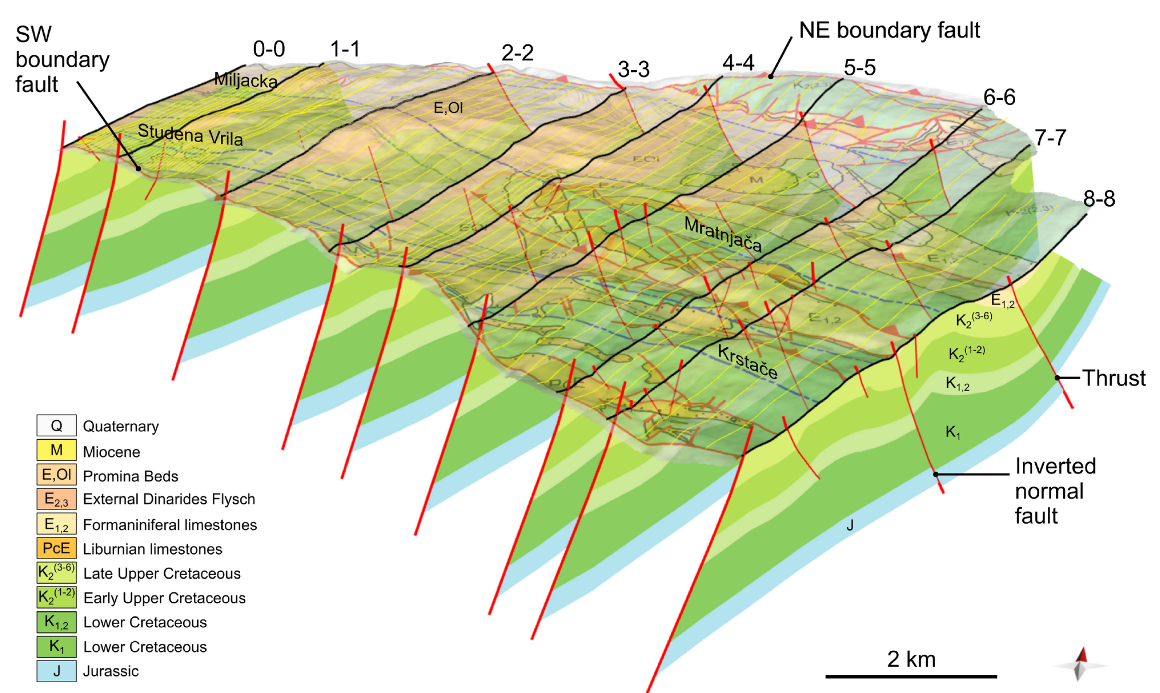
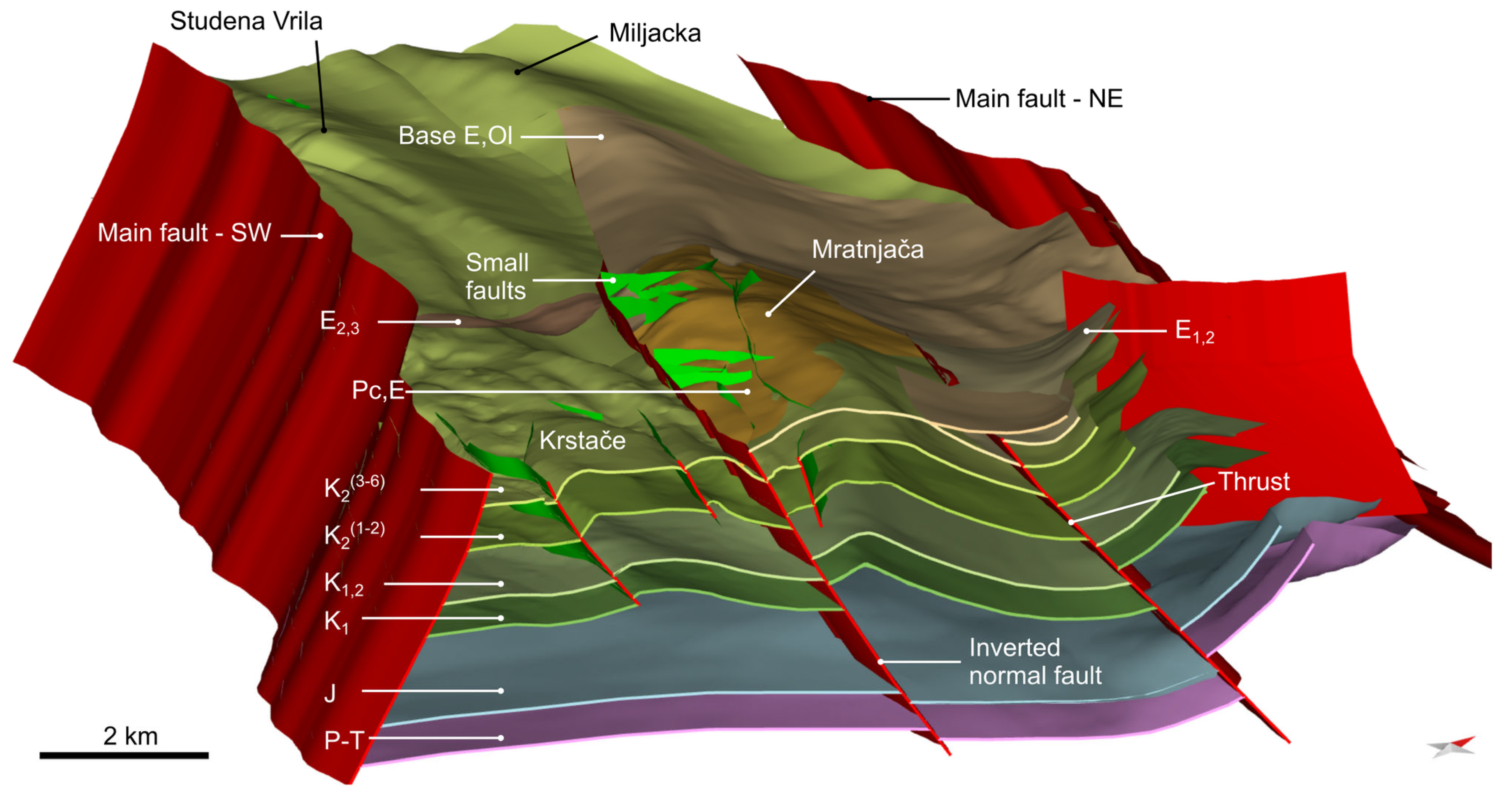
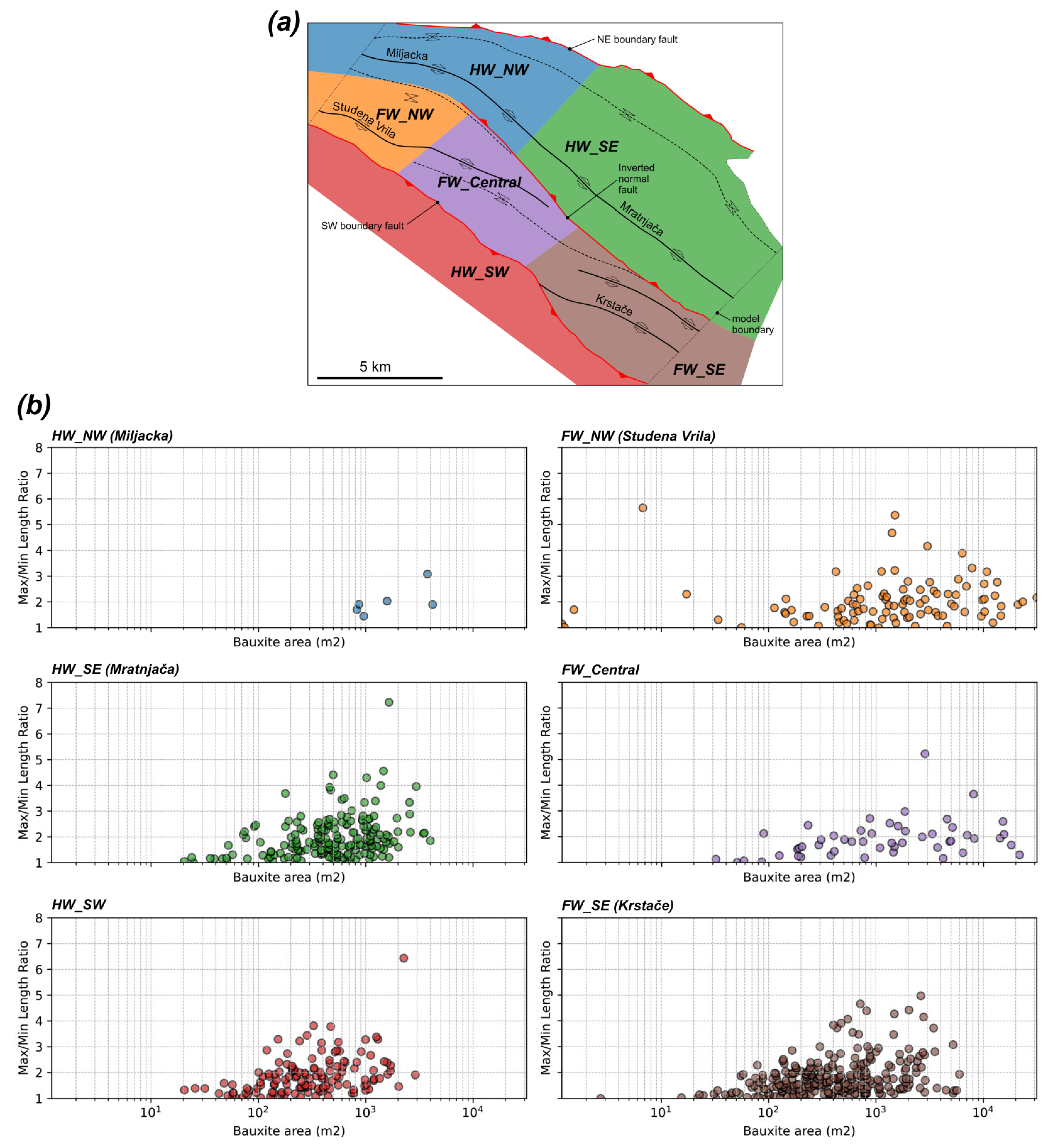
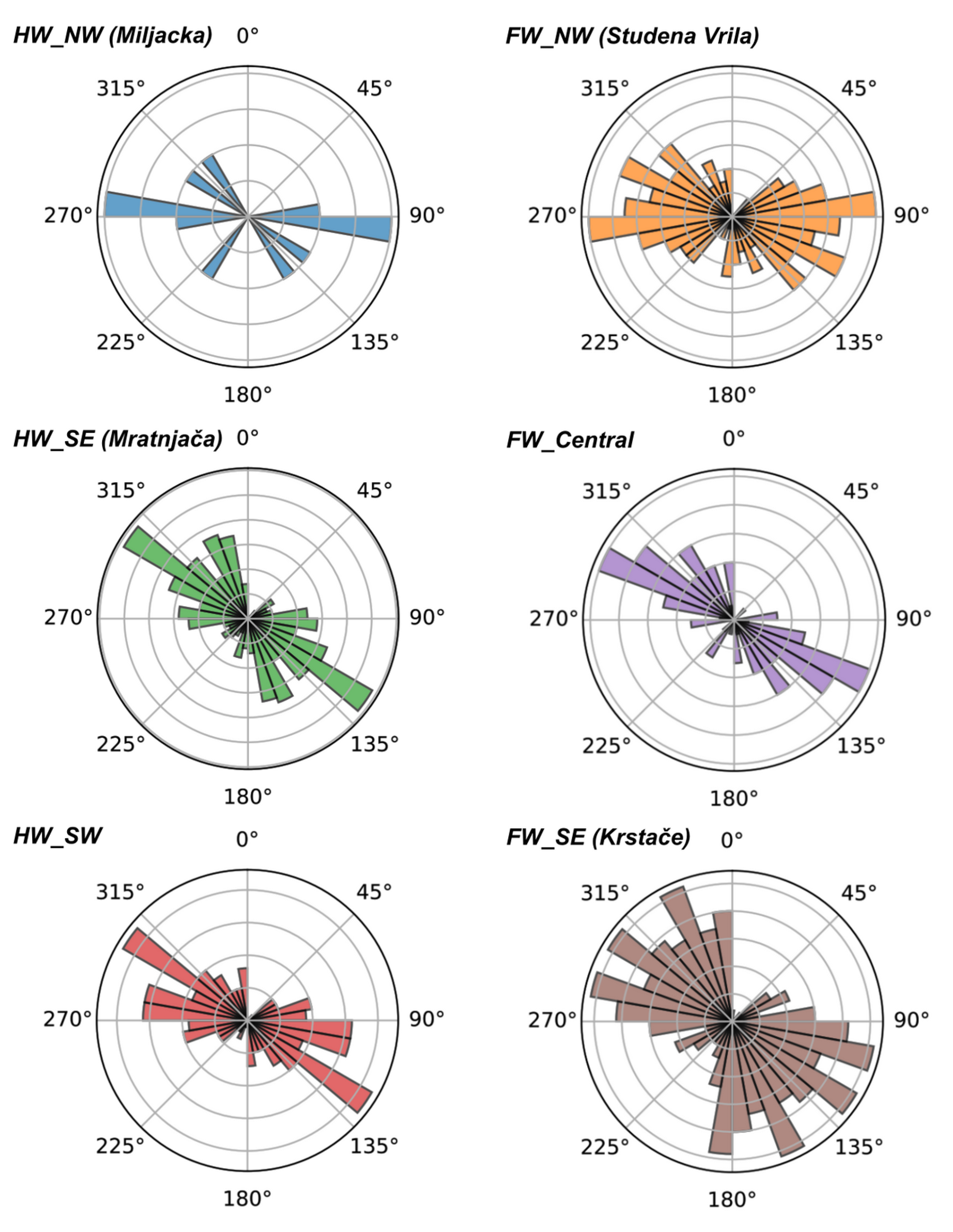
4. Three-Dimensional Geological Model and Bauxite Distribution

The 3D geological model covers a structurally depressed region bounded by large reverse faults to the northeast and southwest (NE and SW boundary faults in Figure 3). These faults, parallel to the local trend of the fold–thrust belt, juxtapose Lower and Upper Cretaceous in their hanging wall to Eocene and Oligocene deposits in their footwall (Figure 1c). The SW boundary fault is identified as a steeply dipping back-thrust with dip-slip kinematic indicators. The model extends from the erosive base of the Promina Beds, at the top, down to the top of the Permo-Triassic sequence, encompassing approximately 3000 m of stratigraphy and reaching a maximum depth of approximately 4000 m (Figure 4).
The model is characterized by roughly NW–SE trending folds and thrusts that curve into a more E–W trend to the NW (Figure 1c). At surface, the most prominent structure is the Mratnjača anticline that exposes the Upper Cretaceous carbonate platform on the SE half of the model. To the southwest, other minor short wavelength anticlines, including the Krstače anticline, expose Upper Cretaceous rocks. These structures extend to the northwest where the Cretaceous platform is only exposed in the core of minor anticlines (e.g., Miljacka and Studena Vrila anticlines), testifying a general deepening of the structural level from southeast to northwest (Figure 1c). The structural level is also higher along the southwest bounding fault, while it reaches its maximum depth along the syncline that occupies the northeastern half of the model, where the top Cretaceous unconformity is predicted to reach a depth of 1200 m (Figure 5). Complex fold axial trace geometries suggest lateral growth and stress field interaction between developing folds. In addition to the NE and SW boundary faults, the two main faults within the model are located on the forelimb and backlimb of the Mratnjača anticline (Figure 4). Other minor faults are modeled within Cretaceous layers along the Mratnjača anticline core and along fore- and backlimbs of other minor folds. The two faults along the Mratnjača anticline are modeled as high-angle thrusts, but only the structure on its southwestern limb is interpreted to be an inverted normal fault (Figure 4). This interpretation is based on the tectonic control this fault exerts on the thickness of the Liburnian and Foraminiferal limestones. In fact, what rests on top of the top Cretaceous unconformity changes rapidly within the modeled area. On both flanks of the Mratnjača anticline (i.e., on the hanging wall of the inverted normal fault), the top Cretaceous unconformity is overlain by 170–350 m of Paleocene–Middle Eocene Liburnian and Foraminiferal limestones. In this stratigraphic interval, the Liburnian limestones have a maximum thickness of 150 m, but, at places, they pinch out and leave the Foraminiferal limestones directly onto the unconformity. Moving southwest, on the footwall of the same fault, these formations are practically absent with exceptions of thin outcrops of Liburnian limestones along the SW boundary fault (Krstače anticline). In this area, the External Dinarides Flysch unconformably overlies the Upper Cretaceous platform. To the northeast, the Liburnian limestones are only found in small highly tectonized outcrops along the NE boundary fault. The Foraminiferal limestones and the External Dinarides Flysch progressively thin towards the north-west and finally pinch out to leave Promina Beds directly on the top Cretaceous unconformity (Miljacka and Studena Vrila anticlines). The highly variable fold wavelength across the basin suggests the occurrence of multiple detachment levels within the Cretaceous stratigraphy.
The bauxite-bearing top Cretaceous unconformity, built with the integration of surface and subsurface data through structural modeling and validation, represents a tool that can guide drilling and geophysical surveying in an early exploration phase. The model can be easily interrogated to provide a map of areas where the top Cretaceous unconformity lies within economically viable mining depths. In this case, the maximum depth that is considered economical for underground bauxite production is 250 m. Figure 5 shows a top Cretaceous unconformity depth map segmented into three main classes according to depth of the top Cretaceous unconformity: (1) Upper Cretaceous platform exposed at surface; (2) unconformity between surface and 250 m depth; and (3) unconformity below 250 m depth. Large underexplored areas are identified on the southwestern half of the model and away from the mapped bauxite occurrences (red polygons) and drilled exploration boreholes (green dots in Figure 5).
The available bauxite occurrence dataset, a mixed dataset including bauxite mapped at surface and bauxite bodies intercepted by exploration boreholes, is obviously biased by available exposure of the unconformity at surface and mining operations, but it can provide valuable insights into the distribution of karst bauxite across different structural domains within the basin. While mapped bauxite bodies lie entirely in the southwestern half of the model, these occur around all Upper Cretaceous outcrops regardless of their structural position. Bauxites are indeed found in the hanging wall and footwall of the inverted normal fault, and they are overlain by the Liburnian and Foraminiferal limestones or directly by the transitional marls and the External Dinarides Flysch/Promina Beds prograding system. They occur in prominent anticline crests (Mratnjača anticline) as well as more structurally depressed areas (e.g., Miljacka and Studena Vrila anticlines).
To evaluate the controls that the tectono-stratigraphic evolution of the area may have exerted on the accumulation and preservation of bauxite bodies, we subdivided the available bauxite polygons into six structural domains for statistical analysis. The six domains are (Figure 6a): (1) southeast hanging wall of the inverted normal fault (HW_SE); (2) northwest hanging wall of the inverted normal fault (HW_NW); (3) hanging wall of the SW boundary fault (HW_SW); (4) southeast footwall of the inverted normal fault (FW_SE); (5) central footwall of the inverted normal fault (FW_Central); and (6) northwest footwall of the inverted normal fault (FW_NW).
Shape parameters were derived from Principal Component Analysis (PCA), which was used to define the orientation and elongation of each polygon (mapped bauxite body) by projecting its vertices onto the principal axes of spatial variance. The aspect ratio is defined as the ratio between the lengths of the polygon along the PCA major and minor axes, and the orientation corresponds to the azimuth of the major axis.
The shapes of bauxite bodies range from nearly circular (aspect ratio close to 1) to highly elongated (aspect ratios greater than 7) and may exhibit complex geometries in map view. In general, small bodies tend to be more circular, while, at increasing sizes, one can find very variable aspect ratios from nearly circular to very elongated (Figure 6b). The elongated bodies are dominantly trending NW–SE and turn into a more E–W trend towards the NW (Figure 7). The trend of the elongated bauxite bodies closely follows the orientation of the main tectonic structures in the model.
Whereas aspect ratio and orientation distribution appear relatively homogeneous across the whole study area, bauxite size shows a preferential distribution. The size distribution plots for the six structural domains are skewed, with many small bodies and few larger ones (Figure 8). In general, we observe larger bodies in the footwall of the inverted normal fault and increasing size towards the NW. In particular, in the hanging wall of the inverted normal fault (HW_SE and HW_NW structural domains), the maximum size of bauxite bodies is approximately 4000 m2 and the median increases from ~500 to ~1300 m2 from SE to NW. In the footwall of the same fault (FW_SE, FW_Central, FW_NW structural domains), the maximum size is generally larger than in the hanging wall and increases from roughly 6000 m2 in the SE to ca. 31,500 m2 in the NW. The median values also increase from SE to NW from 390 to 1470 m2. In the hanging wall of the southwestern boundary fault (HW_SW domain), the bauxite body size is slightly smaller than in the hanging wall of the inverted fault (HW_SE domain). Maximum value here is ca. 2900 m2 and median 290 m2. When the cumulative number of bauxite deposits is plotted as a function of their area (m2) in a log–log plot, data clearly follow a power-law distribution in the 103–104 m2 range, indicating a self-similar (fractal) distribution of bauxite size (Figure 9). The regression line of each dataset has a different exponent (α), suggesting variations in the geological processes controlling deposit formation. Steeper slopes (α < −2) indicate a rapid decrease in the number of large deposits. Shallower slopes (α > −1) imply a higher proportion of large deposits relative to small ones. Deviations from the power-law distribution at lower size values most likely indicate sampling bias, while at higher values they might indicate a natural cut-off. This plot confirms a general increase in the number of large bodies in the footwall of the inverted normal fault, especially in its central and NW parts.

5. Discussion

In the Posušje area, bauxites occur in karstic depressions and cavities at the top of the Late Cretaceous carbonate platform, and, to a minor extent, at the top of Early Eocene Foraminiferal limestones [108]. The hiatus recorded at the top Cretaceous unconformity is highly heterogeneous across the study area, raising the question of whether bauxite accumulation resulted from a single event or multiple stages [36].
The oldest deposits above the unconformity are the Paleocene–Lower Eocene Liburnian limestones (Pc, E). However, in the Krstače anticline and in the northwestern half of the model (Miljacka and Studena Vrila anticlines), the Cretaceous rocks and bauxite deposits are unconformably overlain by the Middle Eocene hemipelagic transitional marls, followed by the Middle–Upper Eocene External Dinarides Flysch (E2,3) to the southeast, or directly by the Upper Eocene–Oligocene Promina Beds (E, Ol) to the northwest.
The heterogeneous distribution of Liburnian and Foraminiferal limestones may reflect two end-member scenarios. In the first case, syn-depositional normal faulting controlled the distribution and thickness of the Liburnian and Foraminiferal limestones during a Paleocene–Early Eocene extensional phase. In this scenario, deposition of Paleocene–Early Eocene carbonates would be limited to the hanging wall of tilted fault blocks, while none or very condensed sedimentation occurred in the footwall. In the second case, a relatively homogeneous thickness of Liburnian and Foraminiferal limestones was locally removed as a consequence of Middle Eocene faulting and localized emersion in the footwall of tilted fault blocks. In both end-member scenarios, in the footwall of the normal faults, Late Cretaceous–Early Paleocene bauxites may have been reworked or replaced with younger bauxite deposits. In the first case, large areas remained emerged during the Paleocene–Middle Eocene, with possible rejuvenation and further maturation of pre-existing karst bauxite accumulations or replacement with younger deposits. In the second case, Late Cretaceous–Paleocene bauxite deposits may have been locally exposed, reworked, or replaced in the Middle Eocene. An alternative scenario where erosion occurs at the base of the transgressive Middle Eocene transitional marls is possible but considered unlikely due to small chances to remove large parts of the tilted fault blocks in a subaqueous environment. We also exclude local removal of Paleocene–Early Eocene rocks by erosion at fold crests of structures formed during an early folding event as their main thickness is found at the crest of the most prominent structure, the Mratnjača anticline. We therefore interpret the Late Cretaceous–Paleocene unconformity to be pre-folding and pre- to syn-kinematic with respect to extensional faults that control the distribution and thickness of Liburnian and Foraminiferal limestones. Normal faulting was likely responsible for the uplift of footwall blocks, where carbonate deposition was inhibited by subaerial exposure or later removed through erosion.
The occurrence of bauxites in the hanging wall of these faults indicates that emersion and bauxite accumulation started before normal faulting and occurred across the whole study area. The occurrence of intense karstification and bauxite deposits of the same age across vast areas of the External Dinarides suggests that this emersion phase has a regional extent and significance [20]. Regardless of the deposits overlaying the top Cretaceous unconformity, the bauxites’ bodies are always found below the Middle Eocene hemipelagic transitional marls that represent the more basinal facies of the foredeep basin. The local absence of the shallow water transgressive Liburnian and Foraminiferal limestones may reflect either non-deposition or erosion during early transgression, possibly due to footwall uplift. In any case, deposition of hemipelagic transitional marls directly on top of the top Cretaceous unconformity may indicate rapid subsidence, leading to a direct transition from subaerial exposure to deeper-water sedimentation. This geometric relationship suggests that bauxites accumulated during one or multiple emersion phases associated with the development of the External Dinarides forebulge (Figure 10—Steps 1–2) [109,110,111] and were subsequently buried underneath the outer (Liburnian and Foraminiferal limestones) and/or inner (External Dinarides Flysch and Promina Beds) depositional systems of the Dinarides fold–thrust belt foredeep basin (Figure 10—Steps 2–4). In the External Hellenides (structurally equivalent to External Dinarides), karst bauxites are found in similar tectonic positions. In the Parnassos–Ghiona area, bauxites accumulated on top of a heavily karstified Cenomanian–Turonian carbonate platform [16]. Although there is no direct mention of forebulge uplift and emersion, researchers relate the unconformity with tectonic “doming” during convergence [16,112]. The occurrence of karst bauxites at the forebulge unconformity is common in other fold–thrust belts. The best analogue is probably represented by the bauxite deposits found in the Simply Folded Belt of the Zagros Mountains. This part of the belt is structurally equivalent to the External Dinarides, and bauxites are found along the regional unconformity that separates the massive shallow marine carbonates of the Sarvak Fm. from the overlain open marine Ilam Fm. [9,113,114]. Similarly to the Posušje area, these bauxite deposits are overlain by outer-shelf to upper-slope carbonates that mark the onset of foredeep subsidence due to flexural loading from advancing tectonic thrust sheets [115]. The Apuseni Mountains in Romania exhibit a more complex tectonic history. However, Early Cretaceous karst bauxites are still found on an unconformity predating the syn-orogenic Barremian to middle Albian flysch associated with the Austrian phase [116].
Recent U-Pb dating of zircons from the Posušje bauxites yielded a maximum age of ~56 Ma (latest Paleocene) for the protolithic material [11]. The data were interpreted as bauxitization during the Paleocene–Eocene Thermal Maximum [117,118,119], with the contribution of siliciclastic material and well-preserved zircons largely transported as volcanic ash [11]. However, significant parts of the zircons from the same deposits were dated to 69–92 Ma (Turonian–Maastrichtian), indicating the contribution of older precursor material. These ages support a bauxite accumulation on the paleokarst surfaces over a longer time and from eolian, volcanic, and terrestrial sources, including reworking of bauxites. The Liburnian limestones exposed in the Posušje area are discontinuous and relatively non-fossiliferous, making biostratigraphic dating challenging. The 56 Ma age of the zircons in the bauxites overlain by Liburnian limestones may indicate that this unit is locally Early Eocene rather than Paleocene and laterally equivalent to Foraminiferal limestones.
The concentration of larger bodies in the footwall of Cenozoic inverted normal faults suggests that localized prolonged or renewed exposure in the forebulge or outer foredeep settings may have produced larger karst depressions for bauxite accumulation or remobilization. However, the areas hosting the larger bauxite bodies also correspond to areas with less pronounced inversion and lower levels of present day exposure (e.g., Miljacka and Studena Vrila anticlines). The difference in size may therefore simply reflect different levels of preservation of the deposits (Figure 10—Step 5). Although we cannot rule out present-day removal as a cause for the observed size distribution, we believe that, at least partially, the differences in size respond to the primary conditions. This is supported by the fact that, in the hanging wall of the inverted normal fault (Mratnjača anticline), the buried bauxite bodies are significantly smaller than those found in the footwall of the same fault, especially towards the NW (e.g., Studena Vrila anticline).
Pre-existing faults and fractures, if not cemented, represent a preferential path for fluid flow [120]. In carbonate rocks, this often translates to dissolution and karstic features aligned along these structures [121,122,123,124]. In the study area, the NW–SE preferential orientation of elongated bauxite bodies is sub-parallel to the Adriatic microplate NE margin and local orientation of the Dinarides fold–thrust belt. This, together with the fact that the bauxite-bearing unconformity separates passive margin deposits from foredeep deposits, suggest that the preferential NW–SE orientation of the karstic depressions hosting bauxite bodies was controlled by either fractures and normal faults developed within the NE Adriatic plate passive margin or by newly formed or reactivated fractures and normal faults associated with forebulge extension. In the External Dinarides, karst bauxites of varying shapes and sizes reflect the diversity of karst depressions and cavities [38]. The increasing amount of elongated shapes for larger body sizes documented in the body PCA-derived aspect ratio vs. size plot (Figure 6b) may indicate progressive coalescence of smaller and rounded karstic features along structurally controlled lineaments or fractured zones to form larger elongated depressions [125].
A systematic analysis of the bauxite maturity and geochemical signature is needed to assess the processes that may have contributed to the size distribution heterogeneity across the study area and to determine to what extent Late Cretaceous–Early Eocene bauxites have been rejuvenated, reworked, or replaced by younger deposits during prolonged or new emersion phases.

6. Conclusions

The geological model built for the Posušje area, together with the systematic analysis of bauxite occurrences, clearly defines zones with higher mining potential within the basin. The top Cretaceous unconformity depth map defines large underexplored areas where the bauxite-bearing surface lies within an economically mineable depth. These areas are located along the southwestern boundary fault and close to proven deposits but also along the crest of a secondary anticline that runs SW of the inverted normal fault. The analysis of bauxite occurrences, together with an improved understanding of the tectono-stratigraphic evolution of the area gained through cross-section balancing and restoration, suggest that larger bauxite bodies are more abundant in the footwall of the inverted normal fault and towards the northwest. Shallower log–log slopes (e.g., FW_NW and FW_Central) in these areas mean a higher proportion of large deposits, making them more favorable for underground mining. On the contrary, areas with steeper slopes (e.g., HW_SE, HW_SW) may require extensive exploration efforts to locate economically viable deposits in the subsurface.
Structural modeling and validation clearly represent a low-cost powerful tool to determine subsurface geometries in structurally complex areas at reasonable resolution and accuracy. Structural modeling can help in identifying high-priority areas and reducing exploration risk. This is particularly true in an early exploration phase when subsurface data are scarce. A modeled bauxite-bearing horizon can be used to plan geophysical surveys and exploration drilling campaigns for the identification of “sweet spots” in selected areas of the basin. Few boreholes can be drilled across new exploration areas to constrain, together with available geophysical data, the initial structural model, further decreasing uncertainty and exploration risks.
In the study area, karst bauxites are primarily associated with the development of a regional forebulge unconformity that formed in the Late Cretaceous–Paleogene at the top of the Adriatic Carbonate Platform. The area was progressively flooded, becoming part of the outer Dinarides foredeep, where Liburnian and Foraminiferal limestones were deposited. This phase was accompanied by normal faulting, which selectively controlled the accumulation and/or preservation of Paleocene (?)–Early Eocene limestones in the hanging walls of the faults. Continued or renewed emersion during the Early–Middle Eocene in the footwalls of syn-depositional normal faults possibly locally rejuvenated, reworked, or replaced Late Cretaceous–Early Eocene bauxites and facilitated the formation of larger bauxite bodies. Although folding and thrusting did not control the primary accumulation of karst bauxites in the study area, recent erosion or remobilization at fold crests may have locally affected their preservation. Detailed geochemical analysis to confirm the bauxite ages and reworking history is necessary to evaluate the extent of these processes.

Author Contributions

Conceptualization, G.C.; Data curation, G.C., I.P. (Ivica Pavičić), I.P. (Ida Pavlin), Š.B. and I.P. (Irena Peytcheva); Formal analysis, G.C.; Funding acquisition, G.C., I.P. (Irena Peytcheva) and F.Š.; Investigation, G.C., E.S., I.P. (Ivica Pavičić), I.P. (Ida Pavlin), Š.B. and I.P. (Irena Peytcheva); Methodology, G.C. and E.S.; Validation, G.C.; Visualization, G.C.; Writing—original draft, G.C.; Writing—review and editing, E.S., I.P. (Ivica Pavičić), I.P. (Ida Pavlin), Š.B., I.P. (Irena Peytcheva) and F.Š. All authors have read and agreed to the published version of the manuscript.

Funding

This study was supported by the AGEMERA project (Agile Exploration and Geo-modelling for European Critical Raw Materials), which has received funding from the European Union’s Horizon Europe research and innovation program (Grant Agreement: 101058178; DOI: https://doi.org/10.3030/101058178).

Data Availability Statement

The raw data supporting the conclusions of this paper will be made available by the corresponding author on request due to internal policy.

Acknowledgments

We sincerely thank Rudnici boksita d.o.o. za eksploataciju rude Posušje (Posušje mine) for providing access to borehole data and information on bauxite occurrences, which were essential for this study. We also extend our gratitude to the editor and reviewers for their constructive feedback, which helped to improve the clarity and quality of this manuscript.

Conflicts of Interest

G.C. and E.S. are associates at Lithica SCCL—a consulting company, beneficiary partner in the Horizon Europe Agemera project (Grant Agreement No. 101058178; DOI: https://doi.org/10.3030/101058178). Lithica SCCL, as a commercial entity, had no involvement in the study design, data collection, analysis, interpretation, or manuscript preparation. Giulio Casini and Eduard Saura declare no conflicts of interest beyond their employment at Lithica SCCL. I.P. (Irena Peytcheva), I.P. (Ivica Pavičić), I.P. (Ida Pavlin), Š.B., and F.Š. declare no conflicts of interest related to the content of this manuscript.

References

  1. Georgitzikis, K.; Mancini, L.; d’Elia, E.; Vidal-Legaz, B. Sustainability Aspects of Bauxite and Aluminium—Climate Change, Environmental, Socio-Economic and Circular Economy Considerations. Publications Office. 2021. Available online: https://data.europa.eu/doi/10.2760/702356 (accessed on 15 February 2025).
  2. SCRREEN. Factsheets Updates. 2023. Available online: https://scrreen.eu/crms-2023/ (accessed on 13 February 2025).
  3. Khosravi, M.; Abedini, A.; Alipour, S.; Mongelli, G. The Darzi-Vali bauxite deposit, West-Azarbaidjan Province, Iran: Critical metals distribution and parental affinities. J. Afr. Earth Sci. 2017, 129, 960972. [Google Scholar] [CrossRef]
  4. Mongelli, G.; Boni, M.; Oggiano, G.; Mameli, P.; Sinisi, R.; Buccione, R.; Mondillo, N. Critical metals distribution in Tethyan karst bauxite: The cretaceous Italian ores. Ore Geol. Rev. 2017, 86, 526–536. [Google Scholar] [CrossRef]
  5. Reinhardt, N.; Proenza, J.A.; Villanova-De-benavent, C.; Aiglsperger, T.; Bover-Arnal, T.; Torró, L.; Salas, R.; Dziggel, A. Geochemistry and mineralogy of rare earth elements (REE) in bauxitic ores of the catalan coastal range, NE Spain. Minerals 2018, 8, 562. [Google Scholar] [CrossRef]
  6. Mondillo, N.; Balassone, G.; Boni, M.; Chelle-Michou, C.; Cretella, S.; Mormone, A.; Putzolu, F.; Santoro, L.; Scognamiglio, G.; Tarallo, M. Rare earth elements (REE) in Al- and Fe-(oxy)-hydroxides in bauxites of provence and languedoc (Southern France): Implications for the potential recovery of rees as by-products of bauxite mining. Minerals 2019, 9, 504. [Google Scholar] [CrossRef]
  7. Abedini, A.; Khosravi, M.; Dill, H. Rare earth element geochemical characteristics of the late Permian Badamlu karst bauxite deposit, NW Iran. J. Afr. Earth Sci. 2020, 172, 103974. [Google Scholar] [CrossRef]
  8. Radusinović, S.; Papadopoulos, A. The potential for REE and associated critical metals in karstic bauxites and bauxite residue of Montenegro. Minerals 2021, 11, 975. [Google Scholar] [CrossRef]
  9. Ahmadnejad, F.; Mongelli, G. Geochemistry of Upper Cretaceous bauxite deposits, Zagros Fold Thrust Belt, SW Iran: Paleoenvironment and provenance constraints. Sediment. Geol. 2023, 454, 106461. [Google Scholar] [CrossRef]
  10. Bilić, Š.; Peytcheva, I.; Georgiev, S.; Hikov, A.; Pavičić, I.; Deljak, G.; Šumanovac, F.; Holma, M. Petrography and geochemistry of Cretaceous bauxites from Jajce, Bosnia and Herzegovina. Rev. Bulg. Geol. Soc. 2023, 84, 77–80. [Google Scholar] [CrossRef]
  11. Peytcheva, I.; Bilić, Š.; Georgiev, S.; Pavičić, I.; Šumanovac, F.; Hikov, A.; Holma, M.; Guillong, M.; Grubišić, I. Posušje bauxites in Bosnia and Herzegovina: A source of critical raw materials and a paleoclimatic marker. Rev. Bulg. Geol. Soc. 2023, 84, 133–136. [Google Scholar] [CrossRef]
  12. Perković, I.; Martinuš, M.; Cvetko Tešović, B.; Vlahović, I.; Matešić, D.; Newton, R.J.; He, T.; Šoufek, M.; Razum, I.; Durn, G. Tracing the evolution of the world’s first mined bauxite from palaeotopography to pyritization: Insights from Minjera deposits, Istria, Croatia. Geol. Croat. 2024, 77, 159–178. [Google Scholar] [CrossRef]
  13. U.S. Geological Survey. Mineral Commodity Summaries 2025; U.S. Geological Survey: Reston, VA, USA, 2025; 212p. [CrossRef]
  14. Idoine, N.E.; Raycraft, E.R.; Shaw, R.A.; Hobbs, S.F.; Deady, E.A.; Everett, P.; Evans, E.J.; Mills, A.J. World Mineral Production 2016–2020; British Geological Survey: Keyworth, Nottingham, 2022.
  15. U.S. Geological Survey. Mineral Commodity Summaries 2018; U.S. Geological Survey: Reston, VA, USA, 2018; 200p. [CrossRef]
  16. Williams, R.J. Karst-Associated Bauxite Deposits of Parnassos-Ghiona, Central Greece: Ore Genesis and Structural Evolution. Ph.D. Thesis, University of Brighton, Brighton, UK, 2014. [Google Scholar]
  17. Timotijević, S. Metallogenetic Prognosis of Bauxite Deposits in Western Serbia; Special Editions of Geoinstitute: Belgrade, Serbia, 1995; 102p. [Google Scholar]
  18. Pajović, M. Geology and Genesis of Red Bauxites of Montenegro; Separate Issues of Geological Bulletin; Geological Survey of Montenegro: Podgorica, Montenegro, 2000; Volume XVII, 242p. [Google Scholar]
  19. Timotijević, S.B. Cretaceous bauxites of Serbia. Poseb. Izd. Geoinstituta 2001, 27, 94. [Google Scholar]
  20. Vlahović, I.; Tišljar, J.; Velić, I.; Matičec, D. Evolution of the Adriatic Carbonate Platform: Palaeogeography, main events and depositional dynamics. Palaeogeogr. Palaeoclimatol. Palaeoecol. 2005, 220, 333–360. [Google Scholar] [CrossRef]
  21. Pajović, M. Genesis and genetic types of karst bauxites. Iran. J. Earth Sci. 2009, 1, 44–56. [Google Scholar]
  22. Pajović, M.; Radusinović, S. Methods for Production of Metallogenic-Prognostic Map of Red Karst Bauxite in the Region of Nikšićka Župa, Montenegro (Europe). Iran. J. Earth Sci. 2012, 4, 12–20. [Google Scholar]
  23. Radusinović, S.; Jelenković, R.; Pačevski, A.; Simić, V.; Božović, D.; Holclajtner-Antunović, I.; Životić, D. Content and mode of occurrences of rare earth elements in the Zagrad karstic bauxite deposit (Nikšić area, Montenegro). Ore Geol. Rev. 2017, 80, 406–428. [Google Scholar] [CrossRef]
  24. Dragičević, I.; Papeš†, J.; Pavičić, I. Geological settings of the Jajce bauxite bearing-area (Bosnia and Herzegovina). J. Maps 2019, 15, 744–750. [Google Scholar] [CrossRef]
  25. Brčić, V.; Dunkl, I.; Mindszenty, A.; Brlek, M.; Trinajstić, N.; Bajo, P.; Bauluz, B.; Mišur, I.; Karius, V.; Šuica, S.; et al. A time-space window between Eocene karst bauxite genesis and the first molasse deposition in the Dinaric Foreland Basin in the North Dalmatia, Croatia. Front. Earth Sci. 2023, 11, 1224164. [Google Scholar] [CrossRef]
  26. Spahić, D.; Tančić, P.; Kurešević, L.; Cvetković, Ž.; Poznanović Spahić, M. The intra-Mesozoic bauxite-bearing truncations of the peri-Neotethyan realm (Dinarides/Vardar Zone): A multidisciplinary approach shedding new light on the Neocimmerian event. Earth-Sci. Rev. 2025, 262, 105040. [Google Scholar] [CrossRef]
  27. Ionescu, G.E. Bauxite development in the North Apuseni mountains, western Romania. Cretac. Res. 1993, 14, 669–683. [Google Scholar] [CrossRef]
  28. Molina, J.M. A review of karst bauxites and related paleokarsts in Spain. Acta Geol. Hung. 1991, 34, 179–194. [Google Scholar]
  29. Molina, J.M.; Ruiz-Ortiz, P.A.; Vera, J.A. Jurassic karst bauxites in the Subbetic, Betic Cordillera, southern Spain. Acta Geol. Hung. 1991, 34, 163–178. [Google Scholar]
  30. Combes, P.-J. Typologie, cadre géodynamique et genèse des bauxites françaises. Geodin. Acta 1990, 4, 91–109. [Google Scholar] [CrossRef]
  31. Guyonnet-Benaize, C.; Lamarche, J.; Masse, J.P.; Villeneuve, M.; Viseur, S. 3D structural modelling of small-deformations in poly-phase faults pattern. Application to the Mid-Cretaceous Durance uplift, Provence (SE France). J. Geodyn. 2010, 50, 81–93. [Google Scholar] [CrossRef]
  32. Tari, G.; Linzer, H.G. Austrian versus Hungarian bauxites in an Alpine tectonic context: A tribute to Prof. Andrea Mindszenty. Foldt. Kozlony 2018, 148, 35–44. [Google Scholar] [CrossRef]
  33. Kelemen, P.; Dunkl, I.; Csillag, G.; Mindszenty, A.; Józsa, S.; Fodor, L.; von Eynatten, H. Origin, timing and paleogeographic implications of Paleogene karst bauxites in the northern Transdanubian range, Hungary. Int. J. Earth Sci. 2023, 112, 243–264. [Google Scholar] [CrossRef]
  34. Boni, M.; Rollinson, G.; Mondillo, N.; Balassone, G.; Santoro, L. Quantitative Mineralogical Characterization of Karst Bauxite Deposits in the Southern Apennines, Italy. Econ. Geol. 2013, 108, 813–833. [Google Scholar] [CrossRef]
  35. Mongelli, G.; Boni, M.; Buccione, R.; Sinisi, R. Geochemistry of the Apulian karst bauxites (southern Italy): Chemical fractionation and parental affinities. Ore Geol. Rev. 2014, 63, 9–21. [Google Scholar] [CrossRef]
  36. Bárdossy, G. Karst bauxites: Bauxite deposits on carbonate rocks. In Developments in Economic Geology, 14; Elsevier Scientific Publishing Company: Amsterdam, The Netherlands, 1982; 441p. [Google Scholar]
  37. Bardossy, G.; Combes, P.-J. Karst Bauxites: Interfingering of Deposition and Palaeoweathering. In Palaeoweathering, Palaeosurfaces and Related Continental Deposits; Thiry, M., Simon-Coinçon, R., Eds.; Blackwell Science: Oxford, UK, 1995; pp. 189–206. [Google Scholar] [CrossRef]
  38. Pavičić, I.; Dragičević, I.; Ivkić, I. High-resolution 3D geological model of the bauxite-bearing area Crvene Stijene (Jajce, Bosnia and Herzegovina) and its application in ongoing research and mining. Geol. Q. 2018, 62, 100–119. [Google Scholar] [CrossRef]
  39. Molinaro, M.; Guezou, J.C.; Leturmy, P.; Eshraghi, S.A.; de Lamotte, D.F. The origin of changes in structural style across the Bandar Abbas syntaxis, SE Zagros (Iran). Mar. Pet. Geol. 2004, 21, 735–752. [Google Scholar] [CrossRef]
  40. Smith, B.; Aubourg, C.; Guézou, J.C.C.; Nazari, H.; Molinaro, M.; Braud, X.; Guya, N. Kinematics of a sigmoidal fold and vertical axis rotation in the east of the Zagros-Makran syntaxis (southern Iran): Paleomagnetic, magnetic fabric and microtectonic approaches. Tectonophysics 2005, 411, 89–109. [Google Scholar] [CrossRef]
  41. Aubourg, C.; Smith, B.; Bakhtari, H.R.; Guya, N.; Eshraghi, A. Tertiary block rotations in the Fars Arc (Zagros, Iran). Geophys. J. Int. 2008, 173, 659–673. [Google Scholar] [CrossRef]
  42. Butler, R.W.H.; Bond, C.E.; Robledo, F. Basement Controls on Structural Evolution in Thin-Skinned Thrust Belts—Implications for Migration of Deformation Into Orogenic Forelands. Tectonics 2025, 44, e2024TC008347. [Google Scholar] [CrossRef]
  43. Butler, R.W.H.; Tavarnelli, E.; Grasso, M. Structural inheritance in mountain belts: An Alpine–Apennine perspective. J. Struct. Geol. 2006, 28, 1893–1908. [Google Scholar] [CrossRef]
  44. Casini, G.; Gillespie, P.A.; Vergés, J.; Romaire, I.; Fernández, N.; Casciello, E.; Saura, E.; Mehl, C.; Homke, S.; Embry, J.-C.; et al. Sub-seismic fractures in foreland fold and thrust belts: Insight from the Lurestan Province, Zagros Mountains, Iran. Pet. Geosci. 2011, 17, 263–282. [Google Scholar] [CrossRef]
  45. Tavani, S.; Parente, M.; Vitale, S.; Iannace, A.; Corradetti, A.; Bottini, C.; Morsalnejad, D.; Mazzoli, S. Early Jurassic rifting of the Arabian passive continental margin of the Neo-Tethys. Field evidence from the Lurestan region of the Zagros fold-and-thrust belt, Iran. Tectonics 2018, 37, 2586–2607. [Google Scholar] [CrossRef]
  46. Macedo, J.; Marshak, S. Controls on the geometry of fold-thrust belt salients. Geol. Soc. Am. Bull. 1999, 111, 1808–1822. [Google Scholar] [CrossRef]
  47. Cotton, J.T.; Koyi, H.A. Modeling of thrust fronts above ductile and frictional detachments: Application to structures in the Salt Range and Potwar Plateau, Pakistan. Geol. Soc. Am. Bull. 2000, 112, 351–363. [Google Scholar] [CrossRef]
  48. Bahroudi, A.; Koyi, H.A. Effect of spatial distribution of Hormuz salt on deformation style in the Zagros fold and thrust belt: An analogue modelling approach. J. Geol. Soc. 2003, 160, 719–733. [Google Scholar] [CrossRef]
  49. Casciello, E.; Vergés, J.; Saura, E.; Casini, G.; Fernández, N.; Blanc, E.; Homke, S.; Hunt, D.W. Fold patterns and multilayer rheology of the Lurestan Province, Zagros Simply Folded Belt (Iran). J. Geol. Soc. 2009, 166, 947–959. [Google Scholar] [CrossRef]
  50. Najafi, M.; Yassaghi, A.; Bahroudi, A.; Vergés, J.; Sherkati, S. Impact of the Late Triassic Dashtak intermediate detachment horizon on anticline geometry in the Central Frontal Fars, SE Zagros fold belt, Iran. Mar. Pet. Geol. 2014, 54, 23–36. [Google Scholar] [CrossRef]
  51. Casini, G.; Romaire, I.; Casciello, E.; Saura, E.; Vergés, J.; Fernández, N.; Hunt, D.W. Fracture characterization in sigmoidal folds: Insights from the Siah Kuh anticline, Zagros, Iran. AAPG Bull. 2018, 102, 369–399. [Google Scholar] [CrossRef]
  52. Koyi, H.A.; Mansurbeg, H. The Role of Multiple Weak Lithologies in the Deformation of Cover Units in the Northwestern Segment of the Zagros Fold-and-Thrust Belt. J. Pet. Geol. 2021, 44, 145–166. [Google Scholar] [CrossRef]
  53. Vergés, J.; Casini, G.; Ruh, J.; Cosgrove, J.; Sherkati, S.; Najafi, M.; Casciello, E.; Saura, E.; Fard, I.A.; Piryaei, A.; et al. Structural style and timing of NW-SE trending Zagros folds in SW Iran: Interaction with north-south tranding Arabian folds and implication for petroleum geology. J. Pet. Geol. 2024, 47, 3–74. [Google Scholar] [CrossRef]
  54. Butler, R.W.H.; Coward, M.P.; Harwood, G.M.; Knipe, R.J. Salt control on thrust geometry, structural style and gravitational collapse along the Himalayan mountain front in the salt range of northern Pakistan. In Dynamical Geology of Salt and Related Structures; Lerche, I., O’Brien, J.J., Eds.; Elsevier: Amsterdam, The Netherlands, 1987; pp. 339–418. [Google Scholar] [CrossRef]
  55. Callot, J.P.; Jahani, S.; Letouzey, J. The Role of Pre-Existing Diapirs in Fold and Thrust Belt Development. In Thrust Belts and Foreland Basins; Lacombe, O., Lavé, J., Roure, F., Vergés, J., Eds.; Frontiers in Earth Sciences; Springer: Berlin/Heidelberg, Germany, 2007; pp. 309–325. [Google Scholar] [CrossRef]
  56. Burrel, L.; Teixell, A. Contractional salt tectonics and role of pre-existing diapiric structures in the Southern Pyrenean foreland fold–thrust belt (Montsec and Serres Marginals). J. Geol. Soc. 2021, 178, jgs2020-jgs085. [Google Scholar] [CrossRef]
  57. Casini, G.; Vergés, J.; Drzewiecki, P.; Ford, M.; Cruset, D.; Wright, W.; Hunt, D. Reconstructing the Iberian salt-bearing rifted margin of the Southern Pyrenees: Insights from the Organyà Basin. Tectonics 2023, 42, e2022TC007715. [Google Scholar] [CrossRef]
  58. Šumanovac, F.; Kapuralić, J.; Pavičić, I.; Perković, L. Assessment of Near-Surface Geophysical Methods Used to Discover Karst Bauxite Deposits in the Dinarides Using the Example of Posušje Area, Bosnia and Herzegovina. Minerals 2024, 14, 378. [Google Scholar] [CrossRef]
  59. Joutsenvaara, J.; Holma, M.; Kuusiniemi, P.; Korteniemi, J.; Seivane, H.; Marti-Linares, D.; Schimmel, M.; Casini, G.; Buffett, G.G.; Pirttijärvi, M.; et al. The Horizon Europe AGEMERA Project: Innovative Non-Invasive Geophysical Methodologies for Mineral Exploration. Adv. Geosci. 2025, 65, 171–180. [Google Scholar] [CrossRef]
  60. Rudnici boksita, d.o.o. za eksploataciju rude Posušje. Private Communication, 2024.
  61. Balling, P.; Tomljenović, B.; Schmid, S.M.; Ustaszewski, K. Contrasting along-strike deformation styles in the central external Dinarides assessed by balanced cross-sections: Implications for the tectonic evolution of its Paleogene flexural foreland basin system. Glob. Planet. Change 2021, 205, 103587. [Google Scholar] [CrossRef]
  62. Raić, V.; Ahac, A.; Papeš, J. Basic Geological Map of Former SFRJ, Sheet Imotski (L33-23), Scale 1:100,000; Institute for Geological Research (IGI), Sarajevo (1962–1967); Federal Geological Survey: Belgrade, Serbia, 1976. [Google Scholar]
  63. Channell, J.E.T.; Tüysüz, O.; Bektas, O.; Sengör, A.M.C. Jurassic-Cretaceous paleomagnetism and paleogeography of the Pontides (Turkey). Tectonics 1996, 15, 201–212. [Google Scholar] [CrossRef]
  64. Pamić, J.; Gušić, I.; Jelaska, V. Geodynamic evolution of the Central Dinarides. Tectonophysics 1998, 297, 251–268. [Google Scholar] [CrossRef]
  65. Chiari, M.; Djerić, N.; Garfagnoli, F.; Hrvatović, H.; Krstić, M.; Levi, N.; Malasoma, A.; Marroni, M.; Menna, F.; Nirta, G.; et al. The geology of the Zlatibor-Maljen area (western Serbia): A geotraverse across the ophiolites of the Dinaric-Hellenic collisional belt. Ofioliti 2011, 36, 139–166. [Google Scholar] [CrossRef]
  66. Gallhofer, D.; von Quadt, A.; Schmid, S.M.; Guillong, M.; Peytcheva, I.; Seghedi, I. Magmatic and tectonic history of Jurassic ophiolites and associated granitoids from the South Apuseni Mountains (Romania). Swiss J. Geosci. 2017, 110, 699–719. [Google Scholar] [CrossRef]
  67. Maffione, M.; van Hinsbergen, D.J.J. Reconstructing plate boundaries in the Jurassic neo-Tethys from the east and west Vardar ophi- olites (Greece and Serbia). Tectonics 2018, 37, 858–887. [Google Scholar] [CrossRef]
  68. Schmid, S.M.; Fügenschuh, B.; Kounov, A.; Maţenco, L.; Nievergelt, P.; Oberhänsli, R.; Pleuger, J.; Schefer, S.; Schuster, R.; Tomljenović, B.; et al. Tectonic units of the Alpine collision zone between Eastern Alps and western Turkey. Gondwana Res. 2020, 78, 308–374. [Google Scholar] [CrossRef]
  69. Šumanovac, F.; Markušić, S.; Engelsfeld, T.; Jurković, K.; Orešković, J. Shallow and deep lithosphere slabs beneath the Dinarides from teleseismic tomography as the result of the Adriatic lithosphere downwelling. Tectonophysics 2017, 712–713, 523–541. [Google Scholar] [CrossRef]
  70. Hua, Y.; Zhao, D.; Xu, Y. P wave anisotropic tomography of the Alps. J. Geophys. Res. Solid Earth 2017, 122, 4509–4528. [Google Scholar] [CrossRef]
  71. Šumanovac, F. Lithosphere structure of the southern Dinarides and continuity of the Adriatic lithosphere slab beneath the northern Dinarides unravelled by seismic modelling. Geosciences 2022, 12, 439. [Google Scholar] [CrossRef]
  72. Dimitrijević, M.D. Geology of Yugoslavia; Geological Institute GEMINI: Belgrade, Serbia, 1997; p. 187. [Google Scholar]
  73. Tari, V. Evolution of the northern and western Dinarides: A tectonostratigraphic approach. Stephan Mueller Spéc. Publ. Ser. 2002, 1, 223–236. [Google Scholar] [CrossRef]
  74. Schmid, S.M.; Bernoulli, D.; Fügenschuh, B.; Matenco, L.; Schefer, S.; Schuster, R.; Tischler, M.; Ustaszewski, K. The Alpine-Carpathian-Dinaridic orogenic system: Correlation and evolution of tectonic units. Swiss J. Geosci. 2008, 101, 139–183. [Google Scholar] [CrossRef]
  75. Tomljenović, B.; Csontos, L.; Márton, E.; Márton, P. Tectonic evolution of the northwestern Internal Dinarides as constrained by structures and rotation of Medvednica Mountains, North Croatia. Geol. Soc. Lond. Spec. Publ. 2008, 298, 145–167. [Google Scholar] [CrossRef]
  76. Placer, L.; Vrabec, M.; Celarc, B. The bases for understanding of the NW Dinarides and Istria Peninsula tectonics. Geologija 2010, 53, 55–86. [Google Scholar] [CrossRef]
  77. Robertson, A.; Karamata, S.; Šarić, K. Overview of ophiolites and related units in the Late Palaeozoic–Early Cenozoic magmatic and tectonic development of Tethys in the northern part of the Balkan region. Lithos 2009, 108, 1–36. [Google Scholar] [CrossRef]
  78. Pamić, J.; Tomljenović, B.; Balen, D. Geodynamic and petrogenetic evolution of alpine ophiolites from the central and NW Dinarides: An overview. Lithos 2002, 65, 113–142. [Google Scholar] [CrossRef]
  79. Ustaszewski, K.; Kounov, A.; Schmid, S.M.; Schaltegger, U.; Krenn, E.; Frank, W.; Fügenschuh, B. Evolution of the Adria-Europe plate boundary in the northern Dinarides: From continent-continent collision to back-arc extension. Tectonics 2010, 29, TC6017. [Google Scholar] [CrossRef]
  80. Handy, M.R.; Ustaszewski, K.; Kissling, E. Reconstructing the Alps–Carpathians–Dinarides as a key to understanding switches in subduction polarity, slab gaps and surface motion. Int. J. Earth Sci. 2015, 104, 1–26. [Google Scholar] [CrossRef]
  81. van Hinsbergen, D.J.J.; Torsvik, T.H.; Schmid, S.M.; Maţenco, L.C.; Maffione, M.; Vissers, R.L.M.; Gürer, D.; Spakman, W. Orogenic architecture of the Mediterranean region and kinematic reconstruction of its tectonic evolution since the Triassic. Gondwana Res. 2020, 81, 79–229. [Google Scholar] [CrossRef]
  82. Dragičević, I.; Benić, J.; Blašković, I. Novi stratigrafski podaci o paleogenskim klastitima Studenih Vrila-Zapadna Hercegovina. Geološki. Vjesnik. 1985, 38, 31–34. [Google Scholar]
  83. Dragičević, I.; Blašković, I.; Tišljar, J.; Benić, J. Stratigraphy of Paleogene Strata within the Mesihovina-Rakitno Area (Western Herzegovina). Geol. Croat. 1992, 45, 25–52. [Google Scholar]
  84. Gobo, K.; Mrinjek, E.; Ćosović, V. Mass-transport deposits and the onset of wedge- top basin development: An example from the Dinaric Foreland Basin, Croatia. J. Sediment. Res. 2020, 90, 1527–1548. [Google Scholar] [CrossRef]
  85. Sokač, B.; Nikler, L.; Velić, I.; Mamužić, P. Basic Geological Map of Former SFRJ, Sheet Gospić (L33–127), Scale 1:100,000; Institute for Geological Research (IGI), Zagreb (1963–1967); Federal Geological Survey: Belgrade, Serbia, 1974. [Google Scholar]
  86. Šušnjara, A.; Sakač, K.; Jelen, B.; Gabrić, A. Upper Permian evaporites and associated rocks of Dalmatia and borderline area of Lika and Bosnia. Geol. Croat. 1992, 45, 95–114. [Google Scholar]
  87. Tišljar, J. Origin and depositional environments of the evaporite and carbonate complex (Upper Permian) from the central part of the Dinarides (Southern Croatia and Western Bosnia). Geol. Croat. 1992, 45, 115–126. [Google Scholar]
  88. Velić, I.; Vlahović, I.; Matičec, D. Depositional sequences and Palaeography of the Adriatic Carbonate Platform. Mem. Della Soc. Geologica Ital. 2002, 57, 141–151. [Google Scholar]
  89. Fio, K.; Spangenberg, J.E.; Vlahović, I.; Sremac, J.; Velić, I.; Mrinjek, E. Stable isotope and trace element stratigraphy across the Permian–Triassic transition: A redefinition of the boundary in the Velebit Mountain, Croatia. Chem. Geol. 2010, 278, 38–57. [Google Scholar] [CrossRef]
  90. Kulušić, A.; Borojević Šostarić, S. Dinaride evaporite mélange: Diagenesis of the Kosovo Polje evaporites. Geol. Croat. 2014, 67, 59–74. [Google Scholar] [CrossRef]
  91. Pamić, J.J. Triassic magmatism of the Dinarides in Yugoslavia. Tectonophysics 1984, 109, 273–307. [Google Scholar] [CrossRef]
  92. Lawrence, S.; Tari-Kovačić, V.; Gjukic, B. Geological evolution model of the Dinarides. Nafta 1995, 46, 103–113. [Google Scholar]
  93. Smirčić, D.; Aljinović, D.; Barudžija, U.; Kolar-Jurkovšek, T. Middle Trias- sic syntectonic sedimentation and volcanic influence in the central part of the External Dinarides, Croatia (Velebit Mts.). Geol. Q. 2020, 64, 220–239. [Google Scholar] [CrossRef]
  94. Jenkyns, H.C. Geochemistry of oceanic anoxic events. Geochem. Geophys. Geosystems 2010, 11, Q03004. [Google Scholar] [CrossRef]
  95. Ćosović, V.; Mrinjek, E.; Nemec, W.; Španiček, J.; Terzić, K. Development of transient carbonate ramps in an evolving foreland basin. Basin Res. 2018, 30, 746–765. [Google Scholar] [CrossRef]
  96. Tešović, B.; Martinuš, M.; Golec, I.; Vlahović, I. Lithostratigraphy and biostratigraphy of the uppermost Cretaceous to lowermost Palaeogene shallow-marine succession: Top of the Adriatic Carbonate Platform at the Likva Cove section (island of Brač, Croatia). Cretac. Res. 2020, 114, 104507. [Google Scholar] [CrossRef]
  97. Tišljar, J.; Vlahović, I.; Velić, I.; Sokač, B. Carbonate platform megafacies of the Jurassic and cretaceous deposits of the Karst Dinarides. Geol. Croat. 2002, 55, 139–170. [Google Scholar] [CrossRef]
  98. Mrinjek, E.; Nemec, W.; Pecinger, V.; Mikša, G.; Vlahović, I.; Ćosović, V.; Velić, I.; Bergant, S.; Matičec, D. The eocene-oligocene promina beds of the Dinaric foreland basin in northern Dalmatia. J. Alp. Geol. 2012, 55, 409–451. [Google Scholar]
  99. Španiček, J.; Ćosović, V.; Mrinjek, E.; Vlahović, I. Early eocene evolution of carbonate depositional environments recorded in the čikola canyon (north almatian foreland basin, Croatia). Geol. Croat. 2017, 70, 11–25. [Google Scholar] [CrossRef]
  100. Marjanac, T. Deposition of megabeds (megaturbidites) and sea-level change in a proximal part of the Eocene-Miocene flysch of Central Dalmatia (Croatia). Geology 1996, 24, 543–546. [Google Scholar] [CrossRef]
  101. Babić, L.; Hernitz-Kučenjak, M.; Ćorić, S.; Zupanič, J. The Middle Eocene age of the supposed Late Oligocene sediments in the flysch of the Pazin basin (Istria, Outer Dinarides). Nat. Croat. 2007, 16, 83–103. [Google Scholar]
  102. Zupanič, J.; Babić, L. Sedimentary evolution of an inner foreland basin margin: Paleogene Promina Beds of the type area, Mt. Promina (Dinarides, Croatia). Geol. Croat. 2011, 64, 101–119. [Google Scholar] [CrossRef]
  103. Persico, D.; Succo, A.; Mittempergher, S.; Storti, F.; Piccinini, E.; Villa, G. Calcareous nannofossil biostratigraphy of the External Dinarides flysch (Vrčić-Staravasa Pag Island, Croatia): A key to an Eocene tectono-stratigraphic and paleoenvironmental interpretation. Geol. J. 2020, 55, 4656–4669. [Google Scholar] [CrossRef]
  104. Ćosović, V.; Balončić, D.; Koić, M.; Marjanac, T.; Moro, A.; Gušić, I.; Jelaska, V. Paleontological evidence of Paleogene transgression on Adriatic carbonate platform. Géologie Méditerranéenne 1994, 21, 49–53. [Google Scholar] [CrossRef]
  105. Zivkovic, S.; Babić, L. Paleoceanographic implications of smaller benthic and planktonic foraminifera from the Eocene Pazin Basin (Coastal Dinarides, Croatia). Facies 2003, 49, 49–60. [Google Scholar] [CrossRef]
  106. de Leeuw, A.; Mandic, O.; Krijgsman, W.; Kuiper, K.; Hrvatović, H. Paleomagnetic and geochronologic constraints on the geodynamic evolution of the Central Dinarides. Tectonophysics 2012, 530, 286–298. [Google Scholar] [CrossRef]
  107. Raić, V.; Ahac, A.; Papeš, J. Explanatory Notes for Sheet Imotski (L33-23), Scale 1:100,000; Institute for Geological Research (IGI), Sarajevo (1968); Federal Geological Survey: Belgrade, Serbia, 1978; 51p. [Google Scholar]
  108. Dragičević, I.; Blašković, I. On Stratigraphy and Bauxitogenesis of Paleogene Bauxites of the Carbonate Dinarides. Geološki Glas. 2001, 34, 5–18. [Google Scholar]
  109. Otoničar, B. Upper Cretaceous to Paleogene forbulge unconformity associated with foreland basin evolution (Kras, Matarsko Podolje and Istria; SW Slovenia and NW Croatia). Acta Carsologica 2007, 36, 101–120. [Google Scholar] [CrossRef]
  110. Peh, Z.; Kovačević Galović, E. Geochemistry of Istrian Lower Palaeogene bauxites—Is it relevant to the extent of subaerial exposure during Cretaceous times? Ore Geol. Rev. 2014, 63, 296–306. [Google Scholar] [CrossRef]
  111. Ilijanić, N.; Kovačević Galović, E.; Gizdavec, N.; Ivkić Filipović, I.; Miko, S.; Peh, Z. Geochemical records in subaerial exposure environments in Croatia using discriminant function analysis of bauxite data. Front. Earth Sci. 2023, 10, 1055435. [Google Scholar] [CrossRef]
  112. Valeton, I.; Biermann, M.; Reche, R.; Rosenberg, F. Genesis of nickel laterites and bauxites in greece during the jurassic and cretaceous, and their relation to ultrabasic parent rocks. Ore Geol. Rev. 1987, 2, 359–404. [Google Scholar] [CrossRef]
  113. Zarasvandi, A.; Charchi, A.; Carranza, E.J.M.; Alizadeh, B. Karst bauxite deposits in the Zagros Mountain Belt, Iran. Ore Geol. Rev. 2008, 34, 521–532. [Google Scholar] [CrossRef]
  114. Khosravi, M.; Vérard, C.; Abedini, A. Palaeogeographic and geodynamic control on the Iranian karst-type bauxite deposits. Ore Geol. Rev. 2021, 139, 104589. [Google Scholar] [CrossRef]
  115. Mehdi, A. Regional stratigraphy of the Zagros fold-thrust belt of Iran and its proforeland evolution. Am. J. Sci. 2004, 304, 1–20. [Google Scholar] [CrossRef]
  116. Reiser, M.K. The Tectonometamorphic Evolution of the Apuseni Mountains During the Cretaceous. Ph.D. Thesis, University of Innsbruck, Innsbruck, Austria, 2015. [Google Scholar]
  117. Kennett, J.P.; Stott, L.D. Abrupt deep-sea warming, palaeoceanographic changes and benthic extinctions at the end of the Palaeocene. Nature 1991, 353, 225–229. [Google Scholar] [CrossRef]
  118. Meissner, K.J.; Bralower, T.J.; Alexander, K.; Jones, T.D.; Sijp, W.; Ward, M. The Paleocene-Eocene Thermal Maximum: How much carbon is enough? Paleoceanography 2014, 29, 946–963. [Google Scholar] [CrossRef]
  119. Gutjahr, M.; Ridgwell, A.; Sexton, P.F.; Anagnostou, E.; Pearson, P.N.; Pälike, H.; Norris, R.D.; Thomas, E.; Foster, G.L. Very large release of mostly volcanic carbon during the Palaeocene–Eocene Thermal Maximum. Nature 2017, 548, 573–577. [Google Scholar] [CrossRef] [PubMed]
  120. Nelson, R. Geologic Analysis of Naturally Fractured Reservoirs; Gulf Professional Publishing: Oxford, UK, 2001; 332p. [Google Scholar]
  121. Deike, G.H. Fracture Controls on Conduit Development. In Karst Hydrology; Springer: Boston, MA, USA, 1989; pp. 259–291. [Google Scholar] [CrossRef]
  122. Deike, R.G. Relations of jointing to orientation of solution cavities in limestones of central Pennsylvania. Am. J. Sci. 1969, 267, 1230–1248. [Google Scholar] [CrossRef]
  123. Palmer, A.N. Stratigraphic and Structural Control of Cave Development and Groundwater Flow in the Mammoth Cave Region. In Karst Hydrology; Springer: Boston, MA, USA, 1989; pp. 293–316. [Google Scholar] [CrossRef]
  124. Wennberg, O.P.; Casini, G.; Jonoud, S.; Peacock, D.C.P. The characteristics of open fractures in carbonate reservoirs and their impact on fluid flow: A discussion. Pet. Geosci. 2016, 22, 91–104. [Google Scholar] [CrossRef]
  125. Sweeting, M.M. Karst landforms. In Geographical Readings; Macmillan: New York, NY, USA, 1972; 362p. [Google Scholar]
Figure 1. (a) Location of (b). (b) Schematic geological map of the Dinarides (modified after [61]) and location of the study area (c). HR—Croatia; SI—Slovenia; BA—Bosnia and Herzegovina; RS—Serbia; ME—Montenegro; HU—Hungary. (c) Detailed geological map of the Posušje area (modified after working 1:25,000 geological maps of the basic 1:100,000 geological map of former SFRJ, Sheet Imotski, L 33–23; [62]).
Minerals 15 00415 g001
Figure 2. Late Cretaceous–Neogene tectono-stratigraphic chart for the principal domains within the Posušje area: northwest, southeast normal fault footwall (FW), and hanging wall (HW). Hiatuses and unconformities marked by gaps and wavy lines in the stratigraphic columns.
Minerals 15 00415 g002
Figure 3. 3D with balanced cross-sections (black traces numbered 0-0 to 8-8) and infilling cross-sections (thin yellow traces). No vertical exaggeration applied.
Minerals 15 00415 g003
Figure 4. Overview of the 3D geological model. E, Ol—Promina Beds; E2,3—External Dynarides Flysch; E1,2—Foraminiferal limestones; Pc,E—Liburnian limestones; K2(3−6) and K2(1−2)—Upper Cretaceous; K1,2 and K1—Lower Cretaceous; J—Jurassic; P-T—Permo-Triassic. No vertical exaggeration applied.
Minerals 15 00415 g004
Figure 5. Top Cretaceous unconformity colored according to depth from surface (contour lines every 25 m).
Minerals 15 00415 g005
Figure 6. (a) Subdivision of the study area in six structural domains. (b) Bauxite body PCA-derived aspect ratio vs. size.
Minerals 15 00415 g006
Figure 7. Azimuth distribution of the bauxite body first principal eigenvector for each structural domain. All bauxite bodies contribute equally to the distribution; no weighting by size or aspect ratio was applied.
Minerals 15 00415 g007
Figure 8. Bauxite size frequency distribution across structural domains.
Minerals 15 00415 g008
Figure 9. Log–log plot of the cumulative number of bauxite deposits as a function of their area (m2) for the different structural domains. Data from the HW_NW domain (Miljacka anticline) have not been plotted due to too few data points.
Minerals 15 00415 g009
Figure 10. Schematic diagram illustrating bauxite accumulation, preservation, and rejuvenation through forebulge, foredeep, and wedge-top settings. Diagrams are not to scale.
Minerals 15 00415 g010
Disclaimer/Publisher’s Note: The statements, opinions and data contained in all publications are solely those of the individual author(s) and contributor(s) and not of MDPI and/or the editor(s). MDPI and/or the editor(s) disclaim responsibility for any injury to people or property resulting from any ideas, methods, instructions or products referred to in the content.

