
Study on the Key Factors Controlling Oil Accumulation in a Multi-Source System: A Case Study of the Chang 9 Reservoir in the Triassic Yanchang Formation, Dingbian Area, Ordos Basin, China
Abstract
1. Introduction
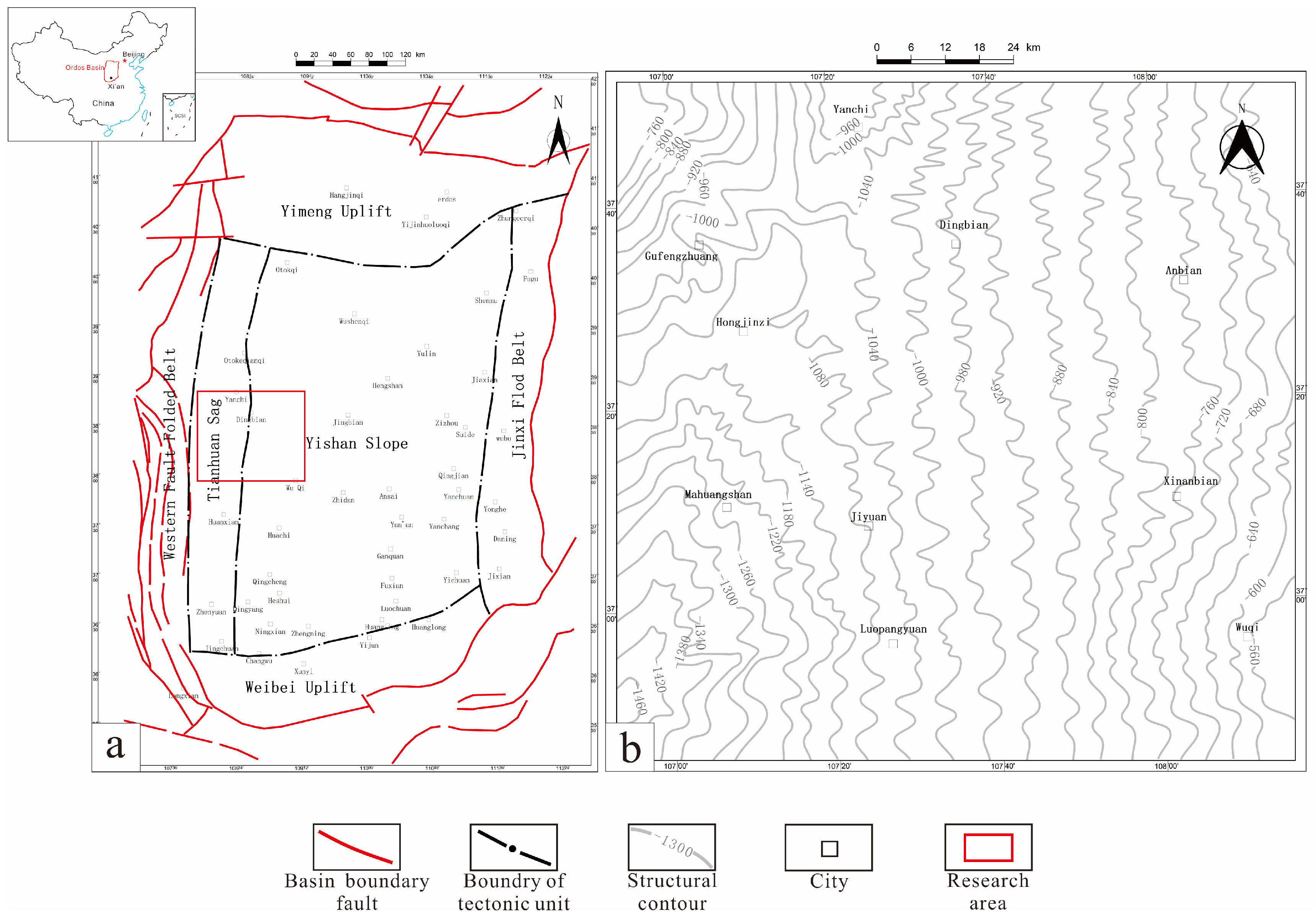
2. Geological Background
3. Samples and Methods
3.1. Samples
3.2. Methods
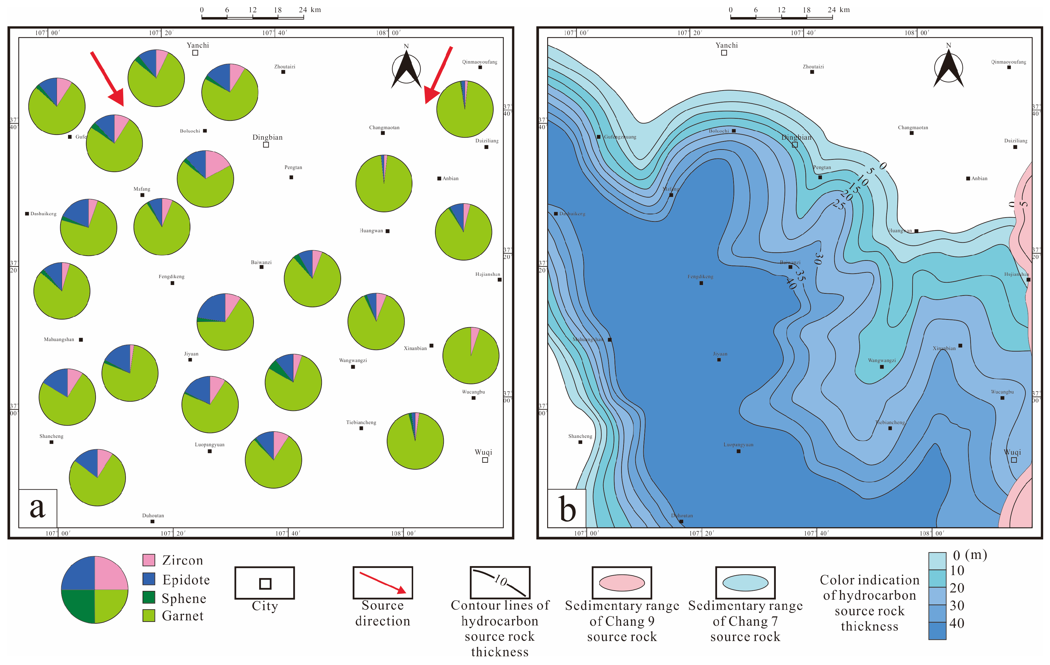
4. Results
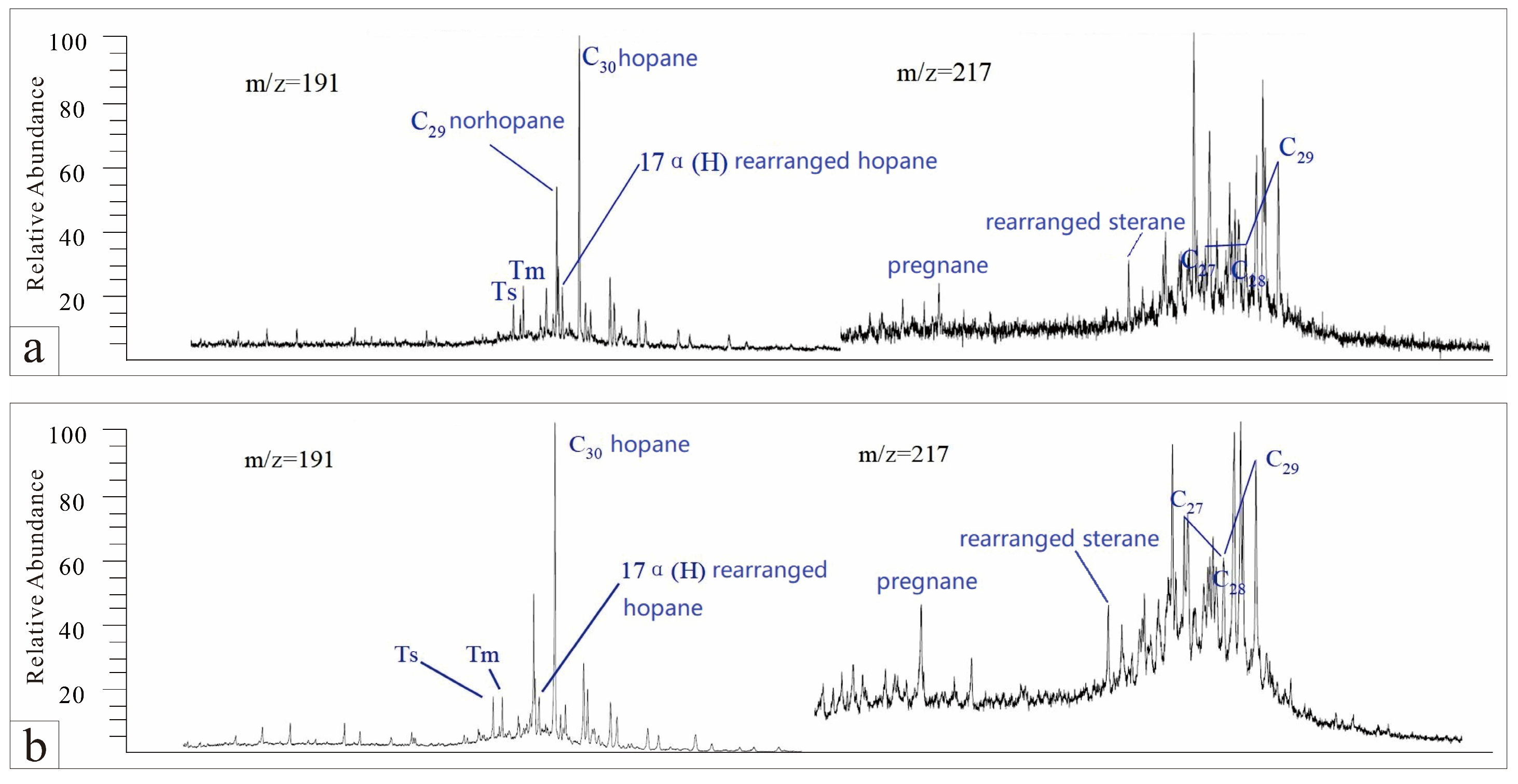
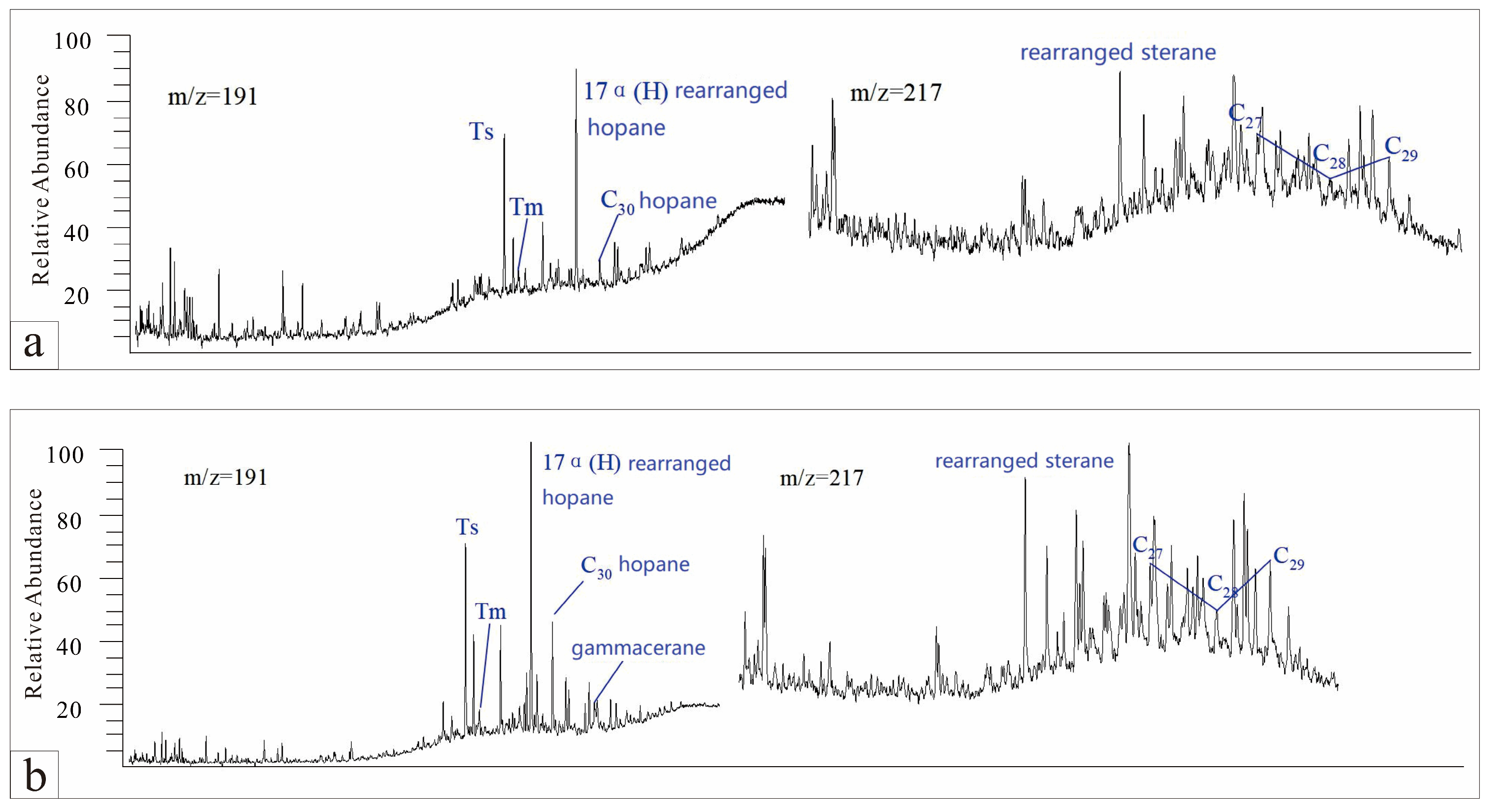
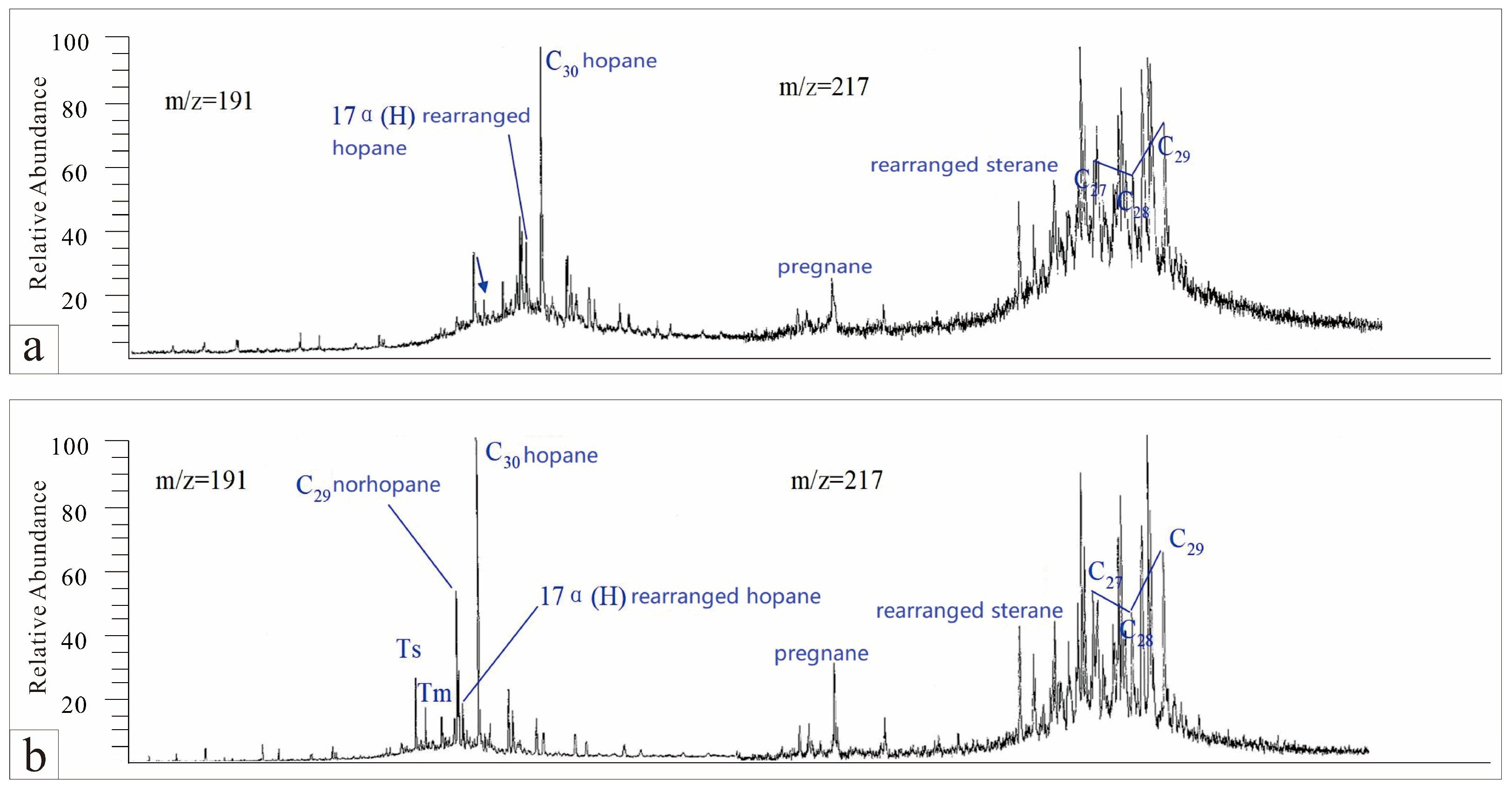
4.1. Oil Source Comparison
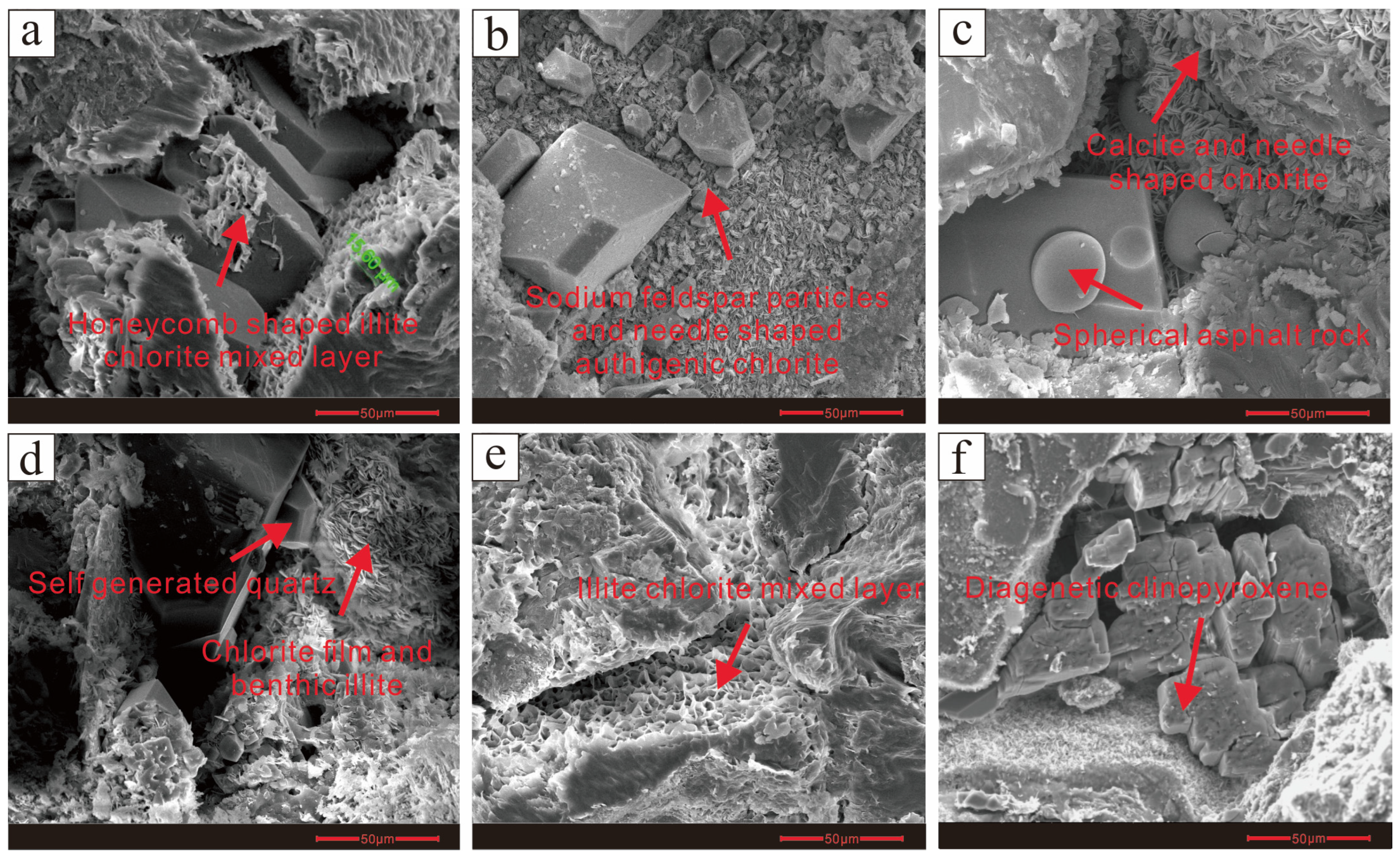
4.2. Reservoir Petrographic Characteristics
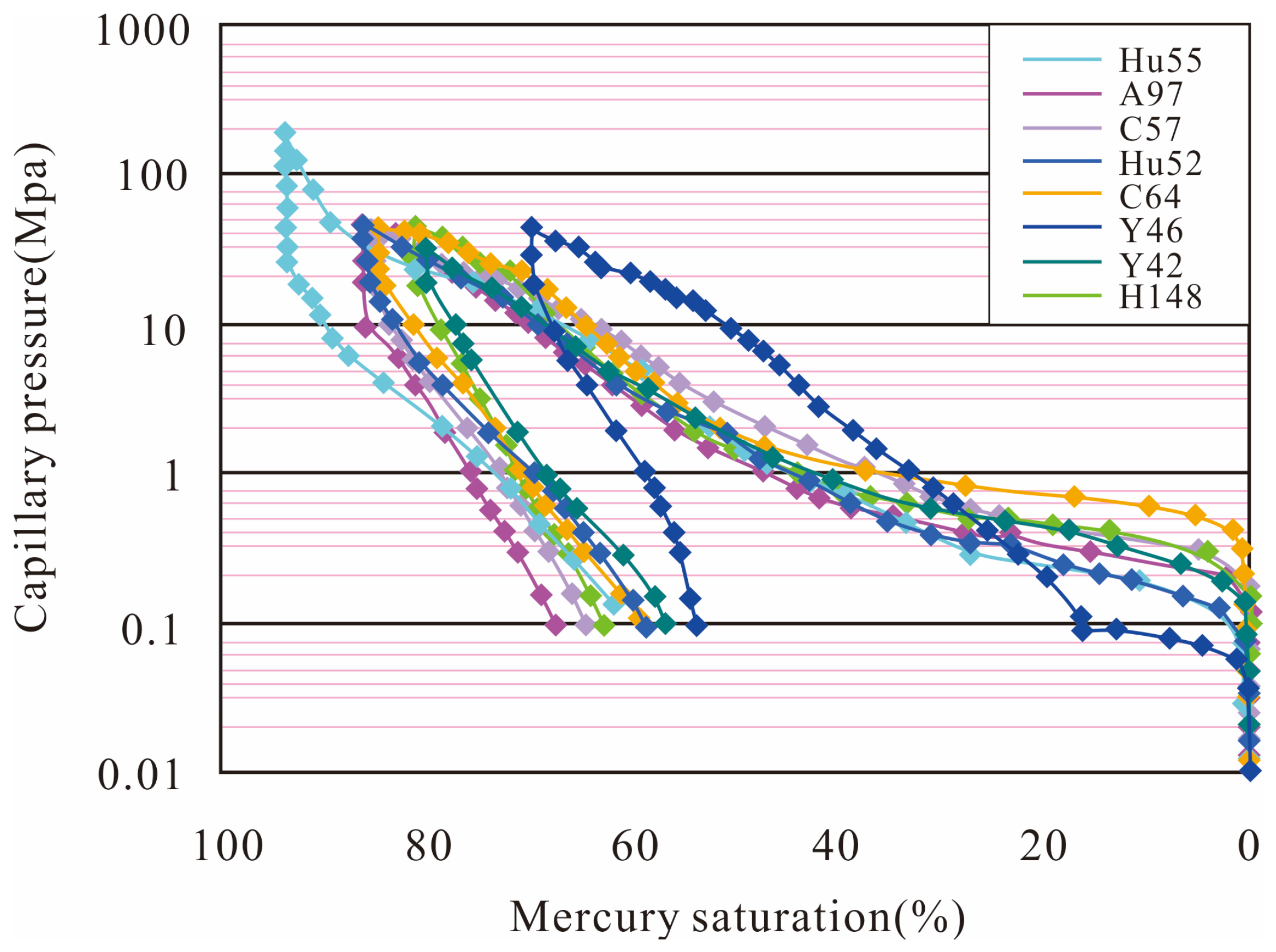
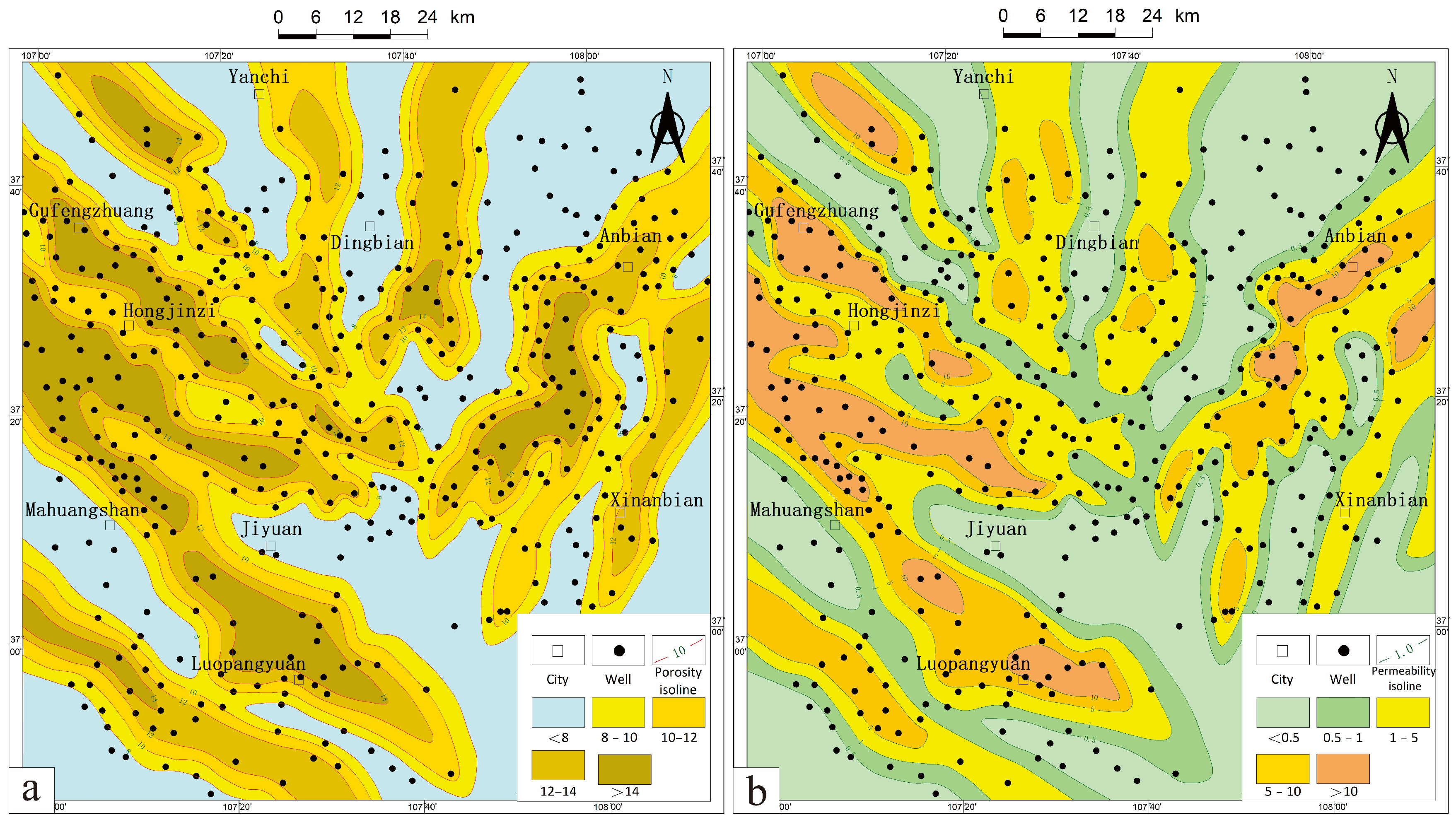
4.3. Reservoir Physical Property
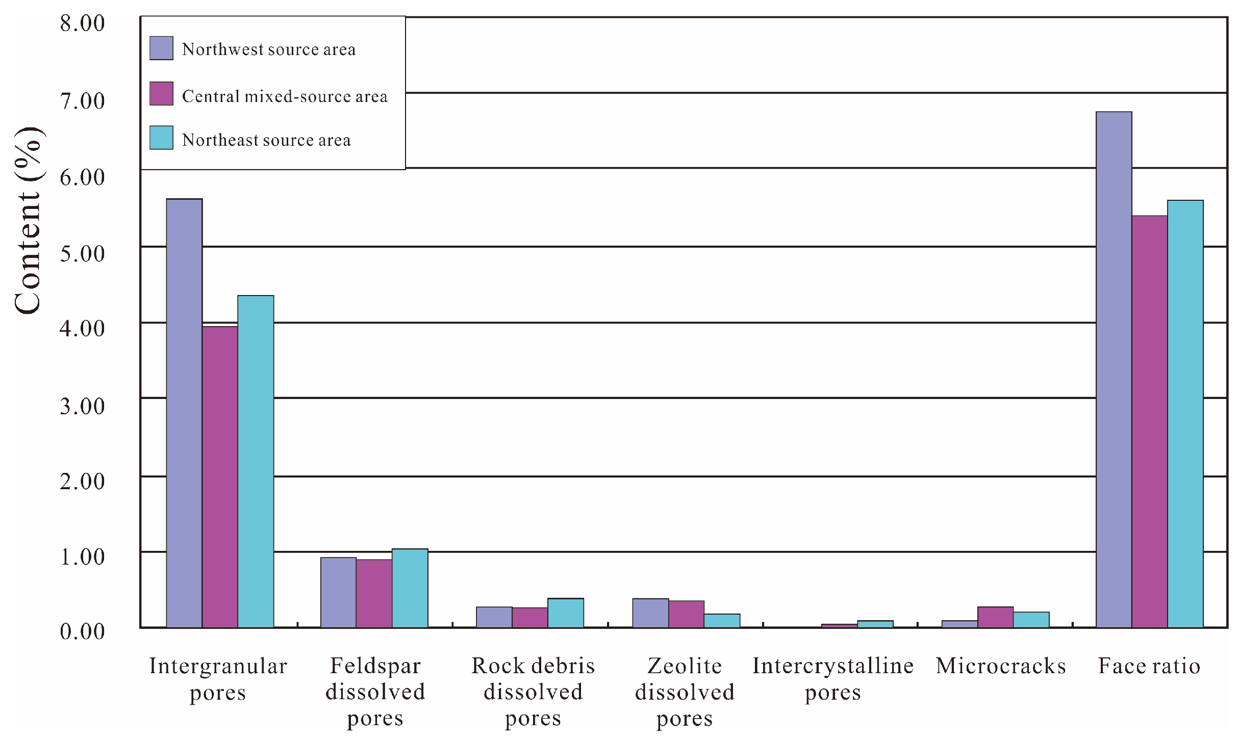
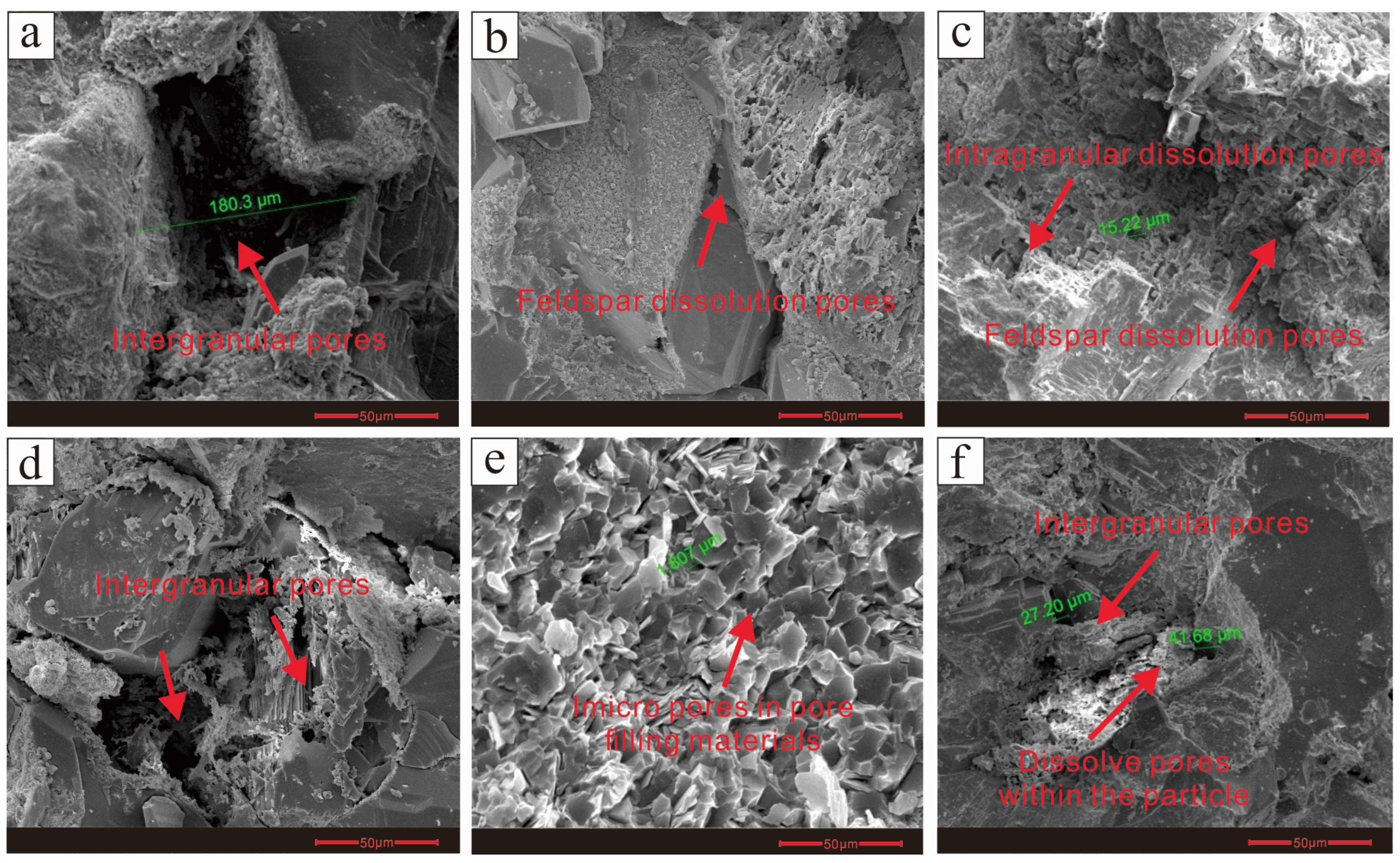
4.4. Reservoir Type
4.5. Crude Oil Properties
5. Discussion
5.1. Impact of Structural Control on Oil Composition and Reservoir Characteristics in Different Source Areas
5.2. Origin and Migration Path of Crude Oil in the Chang 9 Reservoir: Evidence from Biomarker Analysis
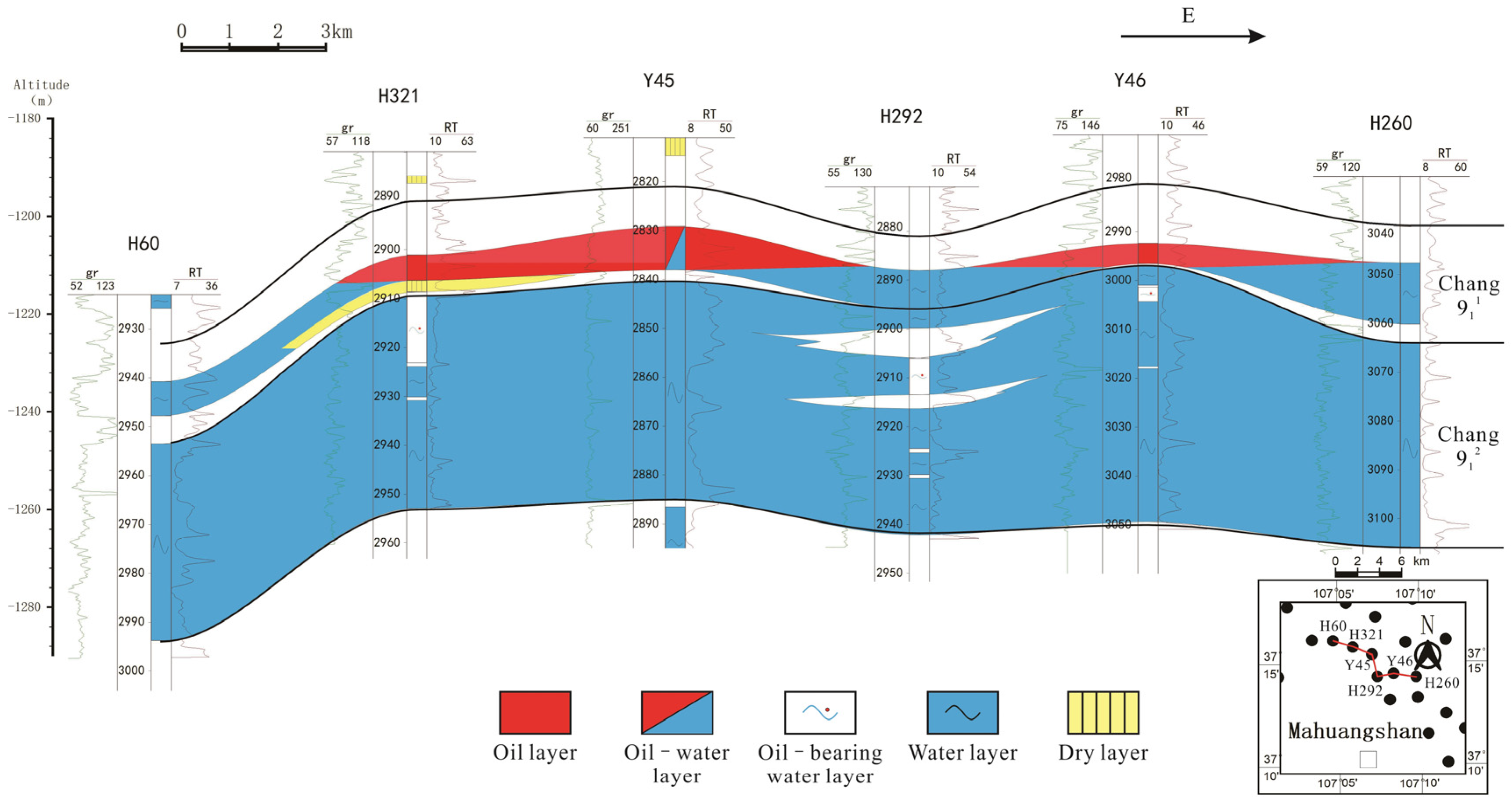
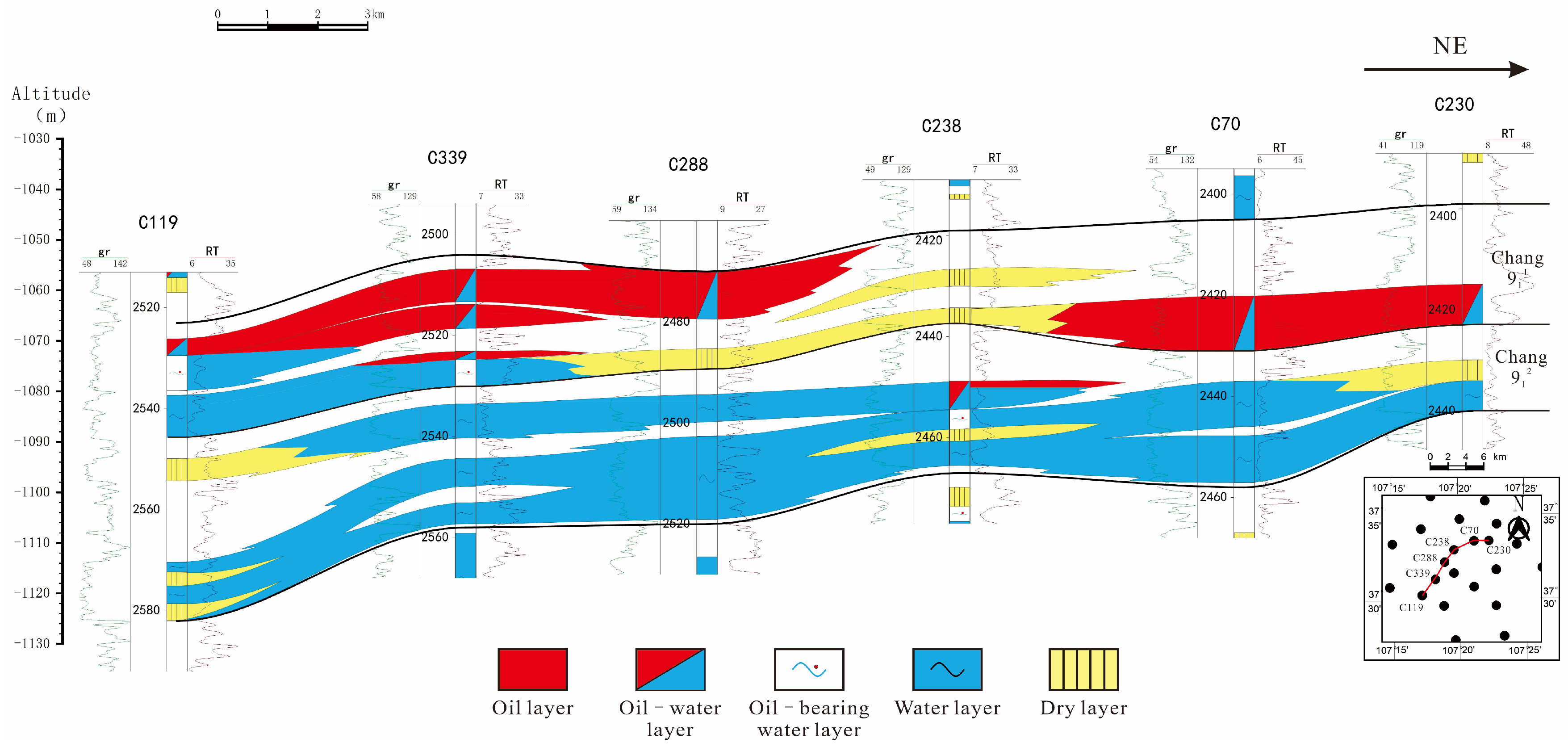
5.3. Oil Accumulation Models in the Dingbian Area: A Zonal Study of Different Source Areas
5.4. Exploration Insights and Technological Outlook
6. Conclusions
Author Contributions
Funding
Data Availability Statement
Acknowledgments
Conflicts of Interest
References
- Galloway, W.E. Process framework for describing the morphologic and stratigraphic evolution of deltaic depositional systems. In Deltas: Models for Exploration; Broussard, M.L., Ed.; Houston Geological Society: Houston, TX, USA, 1975; pp. 87–98. [Google Scholar]
- Bhattacharya, J.P.; Walker, R.G. Deltas. In Facies Models: Response to Sea-Level Change; Walker, R.G., James, N.P., Eds.; Geological Association of Canada: St. John’s, NF, Canada, 1992; pp. 157–177. [Google Scholar]
- Bhattacharya, J.P.; Giosan, L. Wave-influenced deltas: Geomorphological implications for facies reconstruction. Sedimentology 2003, 50, 187–210. [Google Scholar] [CrossRef]
- Lavecchia, G.; de Nardis, R.; Ferrarini, F.; Cirillo, D.; Bello, S.; Brozzetti, F. Regional seismotectonic zonation of hydrocarbon fields in active thrust belts: A case study from Italy. In Building Knowledge for Geohazard Assessment and Management in the Caucasus and Other Orogenic Regions; Springer Netherlands: Berlin/Heidelberg, Germany, 2021; pp. 89–128. [Google Scholar]
- Eshimokhai, S.; Akhirevbulu, O.E. Reservoir characterization using seismic and well logs data (a case study of Niger Delta). Ethiop. J. Environ. Stud. Manag. 2012, 5, 597–603. [Google Scholar] [CrossRef]
- Paillet, F.L.; Crowder, R.E. A generalized approach for the interpretation of geophysical well logs in ground-water studies—Theory and application. Groundwater 1996, 34, 883–898. [Google Scholar] [CrossRef]
- Zhao, P.; Zhuang, W.; Sun, Z.; Wang, Z.; Luo, X.; Mao, Z.; Tong, Z. Methods for estimating petrophysical parameters from well logs in tight oil reservoirs: A case study. J. Geophys. Eng. 2016, 13, 78–85. [Google Scholar] [CrossRef]
- Shanley, K.W.; McCabe, P.J. Perspectives on the sequence stratigraphy of continental strata. AAPG Bull. 1994, 78, 544–568. [Google Scholar]
- Weber, K.J. How Heterogeneity Affects Oil Recovery. In Reservoir Characterization; Lake, L.W., Carroll, H.B., Eds.; Academic Press: Orlando, FL, USA, 1986; pp. 487–544. [Google Scholar]
- Sun, Z.; Lin, S.; Wang, G.; Liu, L.; Wang, M. Sedimentary evolution pattern influenced by sequence stratigraphy: A case study of the Nanpu Sag, Bohai Bay Basin, China. Geosci. Lett. 2024, 11, 30. [Google Scholar] [CrossRef]
- Liu, E.; Wang, H.; Feng, Y.; Pan, S.; Jing, Z.; Ma, Q.; Gan, H.; Zhao, J.-X. Sedimentary architecture and provenance analysis of a sublacustrine fan system in a half-graben rift depression of the South China Sea. Sediment. Geol. 2020, 409, 105781. [Google Scholar] [CrossRef]
- Pettijohn, F.J.; Potter, P.E.; Siever, R. Sand and Sandstone; Springer Business & Media: Berlin/Heidelberg, Germany, 2012; p. 618. [Google Scholar]
- Rocks, S. Petrology of Sedimentary Rocks; Hemphill Publishing Company: Austin, TX, USA, 1968. [Google Scholar]
- Folk, R.L. Petrology of Sedimentary Rocks; Hemphill Publishing Company: Austin, TX, USA, 1980; p. 184. [Google Scholar]
- McManus, J. Grain Size Determination and Interpretation. In Techniques in Sedimentology; Tucker, M., Ed.; Blackwell Scientific Publ.: Hoboken, NJ, USA, 1988; pp. 63–85. [Google Scholar]
- Le Pera, E.; Tangari, A.C.; Marinangeli, L.; Morrone, C.; Riber, L.; Andò, S. Provenance of modern sands from Baja California rivers (Mexico): Petrographic constraints from light and heavy minerals. J. Sediment. Res. 2023, 93, 617–641. [Google Scholar] [CrossRef]
- Garzanti, E.; Andò, S.; Vezzoli, G. Settling equivalence of detrital minerals and grain-size dependence of sediment composition. Earth Planet. Sci. Lett. 2008, 273, 138–151. [Google Scholar] [CrossRef]
- Jiang, Z.; Xiangxin, K.; Yepeng, Y.; Zhang, J.; Zhang, Y.; Li, W.A.N.G.; Xiaodong, Y. Multi-source genesis of continental carbonate-rich fine-grained sedimentary rocks and hydrocarbon sweet spots. Pet. Explor. Dev. 2021, 48, 30–42. [Google Scholar] [CrossRef]
- Zhou, Z.; Zhu, H.; Liu, Q.; Qin, L. The Segmented Multi-Source Sediment Routing System on the Hangingwall Dipslope of the Xihu Depression, East China Sea Shelf Basin: Insights from Palaeogeomorphology, U–Pb Ages and Heavy Minerals. Basin Res. 2024, 36, e70007. [Google Scholar] [CrossRef]
- Hawie, N.; Deschamps, R.; Granjeon, D.; Nader, F.H.; Gorini, C.; Müller, C.; Montadert, L.; Baudin, F. Multi-scale constraints of sediment source to sink systems in frontier basins: A forward stratigraphic modelling case study of the Levant region. Basin Res. 2017, 29, 418–445. [Google Scholar] [CrossRef]
- Ringrose, P.; Bentley, M. Reservoir Model Design; Springer: Berlin/Heidelberg, Germany, 2016; Volume 2. [Google Scholar]
- Frey-Martínez, J.; Cartwright, J.; Hall, B.; Huuse, M. Sand Injectites: Implications for Hydrocarbon Exploration and Production. Sand Inject. Implic. Hydrocarb. Explor. Prod. 2007, 87, 49–63. [Google Scholar]
- Liu, S. The coupling mechanism of basin and orogen in the western Ordos Basin and adjacent regions of China. J. Asian Earth Sci. 1998, 16, 369–383. [Google Scholar] [CrossRef]
- Fu, J.; Dong, G.; Zhou, X.; Hui, X.; Dan, W.; Fan, L.; Wang, Y.; Zhang, H.; Gu, Y.; Zhou, G. Research progress of petroleum geology and exploration technology in Ordos Basin. China Pet. Explor. 2021, 26, 19. [Google Scholar]
- Yang, Y.; Li, W.; Ma, L. Tectonic and stratigraphic controls of hydrocarbon systems in the Ordos basin: A multicycle cratonic basin in central China. AAPG Bull. 2005, 89, 255–269. [Google Scholar] [CrossRef]
- Xiao, X.M.; Zhao, B.Q.; Thu, Z.L.; Song, Z.G.; Wilkins, R.W.T. Upper paleozoic petroleum system, Ordos basin, China. Mar. Pet. Geol. 2005, 22, 945–963. [Google Scholar] [CrossRef]
- Jingli, Y.; Xiuqin, D.; Yande, Z.; Tianyou, H.; Meijuan, C.; Jinlian, P. Characteristics of tight oil in Triassic Yanchang formation, Ordos Basin. Pet. Explor. Dev. 2013, 40, 161–169. [Google Scholar]
- Zhang, C.; Zhang, L.; Chen, T.; Zhang, Y.; Yang, Y.; Huang, J.; He, J.; Li, H. Provenance analysis and source rock types during the deposition of the Chang 7 member of the Yanchang Formation in the Ordos Basin. Acta Sedimentol. Sin. 2013, 31, 430–439. [Google Scholar]
- Wang, B.; He, Y.; Wang, K.; Wang, Y.; Dong, L.; Li, A. Reservoir characteristics of the lower combination of the Yanchang Formation in the Dingbian-Ansei area, Ordos Basin. Lithol. Reserv. 2014, 26, 64–68. [Google Scholar]
- Yang, H.; Fu, J.; Wei, X. Characteristics of natural gas accumulation in the Ordos Basin. Nat. Gas Ind. 2005, 25, 5–8. [Google Scholar]
- Yang, J.; Li, K.; Zhang, D. Petroleum Geology of China, Volume 12: Changqing Oilfield; Petroleum Industry Press: Beijing, China, 1992; Volume 12. [Google Scholar]
- Ritts, B.D.; Hanson, A.D.; Darby, B.J.; Nanson, L.; Berry, A. Sedimentary record of Triassic intraplate extension in North China: Evidence from the nonmarine NW Ordos Basin, Helan Shan and Zhuozi Shan. Tectonophysics 2004, 386, 177–202. [Google Scholar] [CrossRef]
- Yang, Y. Sedimentary systems and sequence characteristics of the Yanchang Formation in the southern Ordos Basin. Geol. Bull. China 2005, 24, 369–372. [Google Scholar]
- Seifert, W.F. Matching the Fluid with the Process. Chem. Eng. 1989, 96, 99. [Google Scholar]
- Parks, L.W.; Smith, S.J.; Crowley, J.H. Biochemical and physiological effects of sterol alterations in yeast—A review. Lipids 1995, 30, 227–230. [Google Scholar] [CrossRef] [PubMed]
- Zhang, S.; Deng, P.; Peng, Y.; Xu, Z.; Li, M.; Xiao, Z.; Yan, G. Origin and source rock potential of Meso-Cenozoic continental oil in the Luntai Uplift, Tarim Basin. Xinjiang Pet. Geol. 1995, 16, 307. [Google Scholar]
- Huang, D.; Xiong, C. Petroleum generation, migration, and potential evaluation of coal-bearing strata. China Pet. Explor. 1996, 1, 6. [Google Scholar]
- Bao, J.; Yang, Q.; Zhu, C. 8,14-Seco-hopane series in marine oils from the Tazhong area, Tarim Basin, and its geochemical significance. Pet. Explor. Dev. 2021, 48, 1077–1088. [Google Scholar] [CrossRef]
- Yang, H.; Liu, X.; Zhang, C.; Han, T.; Hui, X. Key controlling factors and distribution patterns of permeable lithologic oil reservoirs in the Triassic Yanchang Formation, Ordos Basin. Lithol. Reserv. 2007, 19, 1–6. [Google Scholar]
- Tissot, B.P.; Welte, D.H. Petroleum Formation and Occurrence; Springer: Berlin/Heidelberg, Germany, 2013. [Google Scholar]
- Hunt, J.M. Petroleum geochemistry and geology (textbook). In Petroleum Geochemistry and Geology (Textbook), 2nd ed.; WH Freeman Company: New York, NY, USA, 1995. [Google Scholar]
- Larter, S.; Wilhelms, A.; Head, I.; Koopmans, M.; Aplin, A.; Di Primio, R.; Zwach, C.; Erdmann, M.; Telnaes, N. The controls on the composition of biodegraded oils in the deep subsurface—Part 1: Biodegradation rates in petroleum reservoirs. Org. Geochem. 2003, 34, 601–613. [Google Scholar] [CrossRef]
- Pepper, A.S.; Corvi, P.J. Simple kinetic models of petroleum formation. Part III: Modelling an open system. Mar. Pet. Geol. 1995, 12, 417–452. [Google Scholar] [CrossRef]
- Lewan, M.D.; Maynard, J.B. Factors controlling enrichment of vanadium and nickel in the bitumen of organic sedimentary rocks. Geochim. Cosmochim. Acta 1982, 46, 2547–2560. [Google Scholar] [CrossRef]
- Zhu, G.; Milkov, A.V.; Li, J.; Xue, N.; Chen, Y.; Hu, J.; Li, T.; Zhang, Z.; Chen, Z. Deepest oil in Asia: Characteristics of petroleum system in the Tarim basin, China. J. Pet. Sci. Eng. 2021, 199, 108246. [Google Scholar] [CrossRef]


| Sample Name | Sample Type | Stratigraphic Position | Source Area |
|---|---|---|---|
| Sample 1 | Source Rock | Chang 7 | Northwest Area |
| Sample 2 | Source Rock | Chang 7 | Central Mixed Area |
| Sample 3 | Source Rock | Chang 9 | Northeast Area |
| Sample 4 | Source Rock | Chang 9 | Central Mixed Area |
| Sample 5 | Crude Oil | Chang 9 | Northwest Area |
| Sample 6 | Crude Oil | Chang 9 | Northeast Area |
| Source Region | Quartz (%) | Feldspar (%) | Lithic Fragments (%) | |||||||||||||
|---|---|---|---|---|---|---|---|---|---|---|---|---|---|---|---|---|
| Granite | Volcanic Rock | Silver Ore | High-grade Metamorphic Rock | Quartzite | Schist | Phyllite | Metamorphic Sandstone | Slate | Siltstone | Mudstone | Mica | Chlorite | Total (%) | |||
| NorthWest Source Area | 29.8 | 34.5 | 0.1 | 4.9 | 1.9 | 3.2 | 3.0 | 1.7 | 3.1 | 1.6 | 2.0 | 0 | 0.2 | 3.4 | 0.4 | 25.5 |
| North East Source Area | 28.8 | 39.1 | 0.2 | 1.4 | 0.1 | 4.8 | 5.2 | 0.9 | 1.5 | 0.8 | 1.0 | 0 | 0.1 | 3.8 | 0.4 | 20.2 |
| Central Mixed-Source Area | 30.4 | 37.1 | 0.4 | 1.9 | 1.4 | 3.9 | 3.4 | 0.1 | 1.0 | 1.1 | 1.3 | 0.1 | 0.1 | 3.5 | 0.5 | 18.5 |
| Source Region | Kaolinite (%) | Muscovite (%) | Chlorite Film (%) | Tuff (%) | Calcite (%) | Ferroan Calcite (%) | Zeolite (%) | Silica (%) | Total (%) |
|---|---|---|---|---|---|---|---|---|---|
| Northwest Source Area | 0.1 | 1.0 | 3.7 | 0 | 0.3 | 0.2 | 2.0 | 3.0 | 10.2 |
| Northeast Source Area | 0.2 | 1.5 | 3.6 | 0.3 | 1.6 | 1.7 | 2.0 | 1.0 | 11.9 |
| Central Mixed-Source Area | 0.1 | 0.8 | 4.2 | 0 | 0.3 | 1.5 | 3.2 | 4.1 | 14.0 |
| Source Area | Median Radius (μm) | Median Pressure (MPa) | Displacement Pressure (MPa) | Maximum SHg (%) | Mercury Drainage Efficiency (%) |
|---|---|---|---|---|---|
| Northwest Source Area | 0.42 | 1.69 | 0.42 | 80.52 | 26.67 |
| Northeast Source Area | 0.29 | 6.02 | 0.53 | 69.99 | 24.49 |
| Central Mixed-Source Area | 0.31 | 4.97 | 0.52 | 79.69 | 23.48 |
| Source Region | Porosity Range (%) | Average Porosity (%) | Permeability Range (mD) | Average Permeability (mD) |
|---|---|---|---|---|
| Northwest Source Area | 12–16 | 13.4 | 1–10 | 16.25 |
| Northeast Source Area | 10–14 | 11.8 | 1–5 | 5.01 |
| Central Mixed-Source Area | 8–14 | 11.4 | 1–5 | 3.11 |
Disclaimer/Publisher’s Note: The statements, opinions and data contained in all publications are solely those of the individual author(s) and contributor(s) and not of MDPI and/or the editor(s). MDPI and/or the editor(s) disclaim responsibility for any injury to people or property resulting from any ideas, methods, instructions or products referred to in the content. |
© 2025 by the authors. Licensee MDPI, Basel, Switzerland. This article is an open access article distributed under the terms and conditions of the Creative Commons Attribution (CC BY) license (https://creativecommons.org/licenses/by/4.0/).
Share and Cite
Yong, Z.; Zhang, J.; Li, J.; Shi, B.; Wang, Z.; Wang, F. Study on the Key Factors Controlling Oil Accumulation in a Multi-Source System: A Case Study of the Chang 9 Reservoir in the Triassic Yanchang Formation, Dingbian Area, Ordos Basin, China. Minerals 2025, 15, 303. https://doi.org/10.3390/min15030303
Yong Z, Zhang J, Li J, Shi B, Wang Z, Wang F. Study on the Key Factors Controlling Oil Accumulation in a Multi-Source System: A Case Study of the Chang 9 Reservoir in the Triassic Yanchang Formation, Dingbian Area, Ordos Basin, China. Minerals. 2025; 15(3):303. https://doi.org/10.3390/min15030303
Chicago/Turabian StyleYong, Zishu, Jingong Zhang, Jihong Li, Baohong Shi, Zhenze Wang, and Feifei Wang. 2025. "Study on the Key Factors Controlling Oil Accumulation in a Multi-Source System: A Case Study of the Chang 9 Reservoir in the Triassic Yanchang Formation, Dingbian Area, Ordos Basin, China" Minerals 15, no. 3: 303. https://doi.org/10.3390/min15030303
APA StyleYong, Z., Zhang, J., Li, J., Shi, B., Wang, Z., & Wang, F. (2025). Study on the Key Factors Controlling Oil Accumulation in a Multi-Source System: A Case Study of the Chang 9 Reservoir in the Triassic Yanchang Formation, Dingbian Area, Ordos Basin, China. Minerals, 15(3), 303. https://doi.org/10.3390/min15030303