Article

From the Mountain and the Sea: Provenance of the Stones of the Prehistoric La Pastora Tholos (Valencina de la Concepción, Seville, Spain)

by
Luis Miguel Cáceres
1,2,
Teodosio Donaire
1,
Samuel Ramírez-Cruzado
3,
Juan Manuel Vargas
4,
Fernando Muñiz
5,
Mónica Martín
6,
Joaquín Rodríguez-Vidal
1,2,
Francisco Ruiz
1,2,* and
Leonardo García Sanjuán
3
1
Departamento de Ciencias de la Tierra, Universidad de Huelva, Avda. Tres de Marzo, s/n, 21071 Huelva, Spain
2
Centro de Investigación en Patrimonio Histórico, Cultural y Natural (CIPHCN), Facultad de Humanidades, Universidad de Huelva, Avda. Tres de Marzo s/n, 21071 Huelva, Spain
3
Departamento de Prehistoria y Arqueología, Universidad de Sevilla, C/Doña María de Padilla, 41004 Sevilla, Spain
4
Servicio de Arqueología, Ayuntamiento de Valencina de la Concepción, Plaza de España 9, 41907 Valencina de la Concepción, Seville, Spain
5
Departamento de Cristalografía, Mineralogía y Química Agrícola, Facultad de Química, Universidad de Sevilla, C/Prof. García González, s/n, 41012 Seville, Spain
6
Área de Ciencias Experimentales, Universidad C.E.U. Cardenal Espínola CEU, 41930 Bormujos, Sevilla, Spain
*
Author to whom correspondence should be addressed.
Minerals 2024, 14(2), 194; https://doi.org/10.3390/min14020194
Submission received: 18 January 2024 / Revised: 6 February 2024 / Accepted: 9 February 2024 / Published: 12 February 2024

Abstract

:
La Pastora tholos is the most complete and characteristic megalithic monument of the Valencina de la Concepción-Castilleja de Guzmán mega-site. This monument was built using three types of rock, each with different functions and coming from three different places: Paleozoic quartzarenite, granite, and Tertiary calcareous sandstone. A detailed petrological study of the rocks of the tholos and outcrops of similar rocks in the surroundings has been carried out, locating the possible source areas in areas at least 30 km to the N of the monument for the quartzarenite, 15 km for the granite, and 15 km to the S for the sandstone. Therefore, the community that built the monument has a high knowledge of the nature by, which allows them to locate these resources, and a sufficient social organization to exploit them and move them to the mega-site. In this sense, the layout of the outcrops suggests the possible use of boats or rafts to facilitate their displacement, or at least part of their movement.

1. Introduction

The third millennium BC mega-site of Valencina de la Concepción-Castilleja de Guzmán (henceforth Valencina), located about 8 km west of the city of Seville, sits on the Aljarafe plateau, which, with a drop of more than 100 m (even 150 m at some points of the site), dominates the current floodplain of the Guadalquivir River. This floodplain was mostly flooded by oceanic waters [1,2] since the Flandrian maximum, 6500 years ago [3], and in subsequent millennia, constituting a marine inlet part of which was known in Roman times as Lacus Ligustinus.
Thus, the Copper Age site of Valencina was in a privileged geographic position due to its location, topographically dominating the palaeoestuary of the Guadalquivir and the marine gulf the river emptied into. This is very significant in terms of the economic resources as well as the connectivity and communication affordances locally available at the time. In addition to being located on the sedimentary terrains of the Guadalquivir basin, which are very fertile for agriculture, its location was also strategic due to its proximity to the Sierra Morena Mountain range and all the natural resources that this region has to offer (multiple rocky and mineral materials, including copper, biomass, etc.). As a result, the development of the site (Figure 1) reached an extension that far exceeded that of any other sites at the time: with c. 460 ha. [4], it is the largest third millennium site in the Iberian Peninsula and Western Europe [5].
There is currently no consensus on the interpretation of the site. For some authors, it is a continuous and permanently settled dwelling site (a village) with areas of specialization in different manufactures [6]. However, other authors have pointed to reasonable doubts as to the true entity of the site, interpreting it as an aggregation center that, seasonally and at certain symbolic times or periods, would bring together the surrounding communities during the third millennium BC [5]. In any case, the society that occupied the site reached a high degree of development and sophistication.
Proof of the complexity of the site and of the society that inhabited it are the megalithic constructions that are still preserved today, such as Ontiveros, Montelirio, La Pastora, Matarrubilla, and Structure 10.042–10.049 (Figure 1). In addition, each of these monuments has its own distinctive characteristics in terms of its architecture and construction materials. Thus, for example, La Pastora and Matarrubilla have masonry walls and capstones made of sandstone and granite, but in Matarrubilla, its chamber is occupied by a large quadrangular monolithic basin carved in gypsum [7,8]. On the other hand, in Montelirio and Ontiveros, the walls are formed by vertical orthostats of shale, but the first one has two chambers, and the roofing was achieved by means of domes of sun-dried marl and clay [9]. For its part, the structure 10.042–10.049 is smaller and has slate slabs covering the walls but without supporting function, neither in the corridor nor in its two chambers [10].
The study of the geological materials with which the megalithic monuments were built is the first step in their geoarchaeological analysis. This analysis is basic for the determination of the source areas (i.e., quarries) and the estimation of transport distances. With this knowledge, it is more feasible to approach the characteristics of the societies that built them, including their social organization, worldview, knowledge of the natural environment, and even their technical capabilities [11]. Among these capabilities, those related to the extraction of rocks and their transport are very significant, although it is not always possible to obtain direct data on these activities. Whenever specific quarries can be identified, it is possible to look for evidence of the extraction procedures and tools used. On the other hand, the evidence of the means of transport used will always be more linked to speculation and experimental tests than to the finding of empirical evidence.
Geoarchaeological studies along the lines mentioned above have been carried out at major world sites, such as Stonehenge (Great Britain) [12,13] or Easter Island [14], providing fundamental data on quarry areas and rock transport. In the Iberian Peninsula, where thousands of megaliths have been discovered and catalogued, however, geoarchaeological approaches have been undertaken only in a few cases. These include La Chabola de la Hechicera, Dolmen de Aizkomendi, and Puigseslloses [15,16,17,18], in the north; Vale Rodrigo, Anta da Lajinha, and Freixo-Redondo, in Portugal [19,20,21]; El Portillo in inner Iberia [22]; and Alberite [23], Palacio III [24], Panoría [25], El Pozuelo [26], and Menga [11] in the south.
Regarding Valencina, characterization studies of the rocks used to build the tholoi of La Pastora, Matarrubilla, and Montelirio have been carried out [7,8,27], but a detailed analysis of the provenance of these materials has not been addressed so far. In this paper, the main objective will be to determine the source areas of the three types of rocks used to build La Pastora, establishing the minimum distances to the deposit itself. We will also suggest possible means and types of transport that could have been used. Therefore, the study presented here is geoarchaeological in character, although its approach differs from the traditional currents developed by the French and Anglo-Saxon schools [28]. The main aim of our work is linked to the analysis of the organization of settlements at the regional level, based on the development of models of resource exploitation and management. The resources, in this case, are the lithic elements used for the construction of the megalithic monument of La Pastora.

2. La Pastora Tholos

Of all the major megalithic monuments currently known at the Valencina mega-site La Pastora is perhaps the most representative, complete, and least altered. It is a tholos-type structure with a long corridor and a circular chamber roofed by corbelling topped with a massive capstone (Figure 2). The roofs of both the corridor and the chamber are made of large stone slabs, and the whole is covered by a tumulus of loose materials. In this case, the tumulus is very degraded, but it is known to have reached, at least at the time of its discovery in 1860, a maximum thickness of about 2 m [29].
The corridor of La Pastora is 44.36 m long, making it the longest of all Iberian megaliths, while its average width is 1 m, although its section is slightly trapezoidal. This corridor is divided into three sections that are separated by vertical and protruding orthostats, like “doors” with jambs, a lintel (the middle “door”), and a threshold step (in the access into the chamber). These “doors” are preserved between the second and third sections and at the threshold of the entrance to the chamber. Of the three sections of the corridor, the two closest to the chamber are in perfect condition, while the first (the most external) does not preserve the capstone cover. Thus, the height in these two sections varies from 1.4 to 1.8 m. On the other hand, the chamber has a diameter of 2.6 m and a height of 2.7 m. Therefore, the total length of the monument is 46.96 m [30]. Another relevant feature is its orientation towards sunset (243°), which runs counter to that of most Iberian megaliths towards sunrise [31].
La Pastora was built in a uniform manner, with no recognizable phasing, distinctions, or later reconstructions. The only alterations are recent, after its discovery, and of minor importance, such as the niche in the chamber and the specific place where it was accessed in the 19th century [30].
The monument is built with three types of rocks (Figure 2): quartzarenite in smaller blocks, forming the dry masonry walls; large granite blocks used as capstones in the chamber and part of the corridor (six preserved in total); and calcareous sandstone used with diverse functionalities: in the two upper rows of the chamber wall, capstones in a large part of the corridor (20 of which are preserved), jambs, lintels, and floor slabs [7,8].

3. Geological Setting

La Pastora tholos is built on sediments deposited in the Guadalquivir Basin (Figure 3), one of the main Cenozoic sedimentary basins of the Iberian Peninsula. It has an ENE to WSW elongated triangular outline, with an approximate length of 360 km and about 110 km on its SW side. Towards the northern margin, the sediments are autochthonous and are unconformably disposed on the Paleozoic rocks of the Iberian Massif, a large geological unit that occupies most of the western Iberian Peninsula. On the southern margin, sedimentary deposits are related to orogenic activity in the Betic Cordillera [32,33].
Valencina and La Pastora are located on the northern margin of the Guadalquivir Basin, where the stratigraphic sequence presents the following lithologies from the base to the top:
(1)
Sandstone and conglomerates with carbonated cement date back to the late Tortonian [34].
(2)
Blue Marl Unit [34]: marine gray-greenish marl from the Miocene (late Tortonian–Messinian).
(3)
Transition facies [35]: marly clay, sand, and sandstone deposited in the Upper Miocene.
(4)
Pliocene sand and silt [34]: yellow sandy silt with calcareous nodules (Lower Pliocene), sandier and more reddish upward.
(5)
Finally, the Quaternary is basically made up of eolian and coastal sandy deposits, fluvial sand, gravel, and marsh clay (Figure 3).
About 15 km north of Valencina, the Iberian Massif outcrops extend widely to the east and west. The Iberian Massif is divided into several zones with different lithological and structural features. Thus, in the study sector, the sedimentary rocks of the Guadalquivir Basin were deposited on the southernmost area, named the South Portuguese Zone (SPZ). This zone is formed by rocks from the Upper Devonian to the Permian and is divided into various geological domains. The Iberian Pyritic Belt (IPB) and the Sierra Norte de Sevilla batholith (SNSB) are the domains that crop out in this area, as well as volcanic and sedimentary formations of the Permian Viar Basin (PVB). The IPB is further subdivided into three groups [36,37] (Figure 3):
(1)
The Phyllite–Quartzite (PQ) Group is formed by quartzarenites and shales of late Devonian age.
(2)
The Volcano–Sedimentary Complex has a predominance of volcanic and sedimentary rocks interstratified, as well as rocks of chemical origin. The largest massive sulfide deposits are located in this complex.
(3)
The Culm Group is formed by greywackes and shales. The age of this and the previous group is Carboniferous.
The rocks of the SNSB intrude into the previous formations from the Devonic to the early Carboniferous and are characterized by their abundance and types of plutonic rocks, from ultramafic/mafic to granitoid rocks [38].

4. Materials and Methods

The geoarchaeological study of the stones from La Pastora tholos has been approached from the perspective of their characterization and petrographic analysis. Petrography is a discipline that studies rocks from the point of view of their description, mineralogical composition, and structure. Thus, a petrographic study includes a visual analysis of the rock and a detailed petrographic microscopic study. In this way, the rocks are characterized in terms of their arrangement, texture, mineralogy, organic components, and classification. With these well-defined characteristics, it is possible to compare samples from megaliths with those from rock outcrops to determine, based on their similarity or difference, the possible provenance of the stones used to build each monument.
First, the rock was analyzed as a whole by direct observation, both in the monument and in the outcrop identified as the most probable source area. In both cases, the properties concerning the appearance, fabric, general color, texture, fossiliferous content, and mineralogy are determined visually. On the other hand, structural characteristics, including its disposition, the existence and characteristics of discontinuities such as fractures, foliation, or stratification surfaces, as well as the relationship with other rocks in the surrounding area, are examined through fieldwork.
Secondly, thin sections of rock samples from both monument and outcrops are studied by petrographic microscopy. In this case, a Nikon Eclipse LV-100 POL polarized light microscope connected with a Nikon DS-Fi digital camera (Nikon Instruments Inc., Tokyo, Japan), available at the Laboratory of the Department of Earth Sciences, University of Huelva (Huelva, Spain), has been used. The thin sections were made at the Central Laboratories of the University of Huelva and were analyzed under plane and cross-polarized transmitted light. This analysis reveals the shape and size of the minerals that make up the rock, the nature of these minerals, their abundance, the spatial relationship between them (texture), the existence and percentage of the matrix, the microstructure, microfossils, and a whole series of evaluable properties. In this way, the rock can be classified and some specific aspects related to its formation and evolution can be determined [39,40,41].
The rocks were sampled for thin sections differently depending on whether they were from the monument or the field. In the case of the latter, it has been possible to extract a larger number of samples of greater size. On the other hand, given the monument’s protected heritage status, sampling has been much more restricted. Loose or nearly loose fragments of La Pastora stones have been taken in most cases, and always in inconspicuous areas of the monument. Therefore, in this case, the sampling has not been intensive, nor has it encompassed all the stones of the monument, although, overall, the sampling achieved is considered sufficient to account for the diversity of rock types present in the monument.

5. Results and Discussion

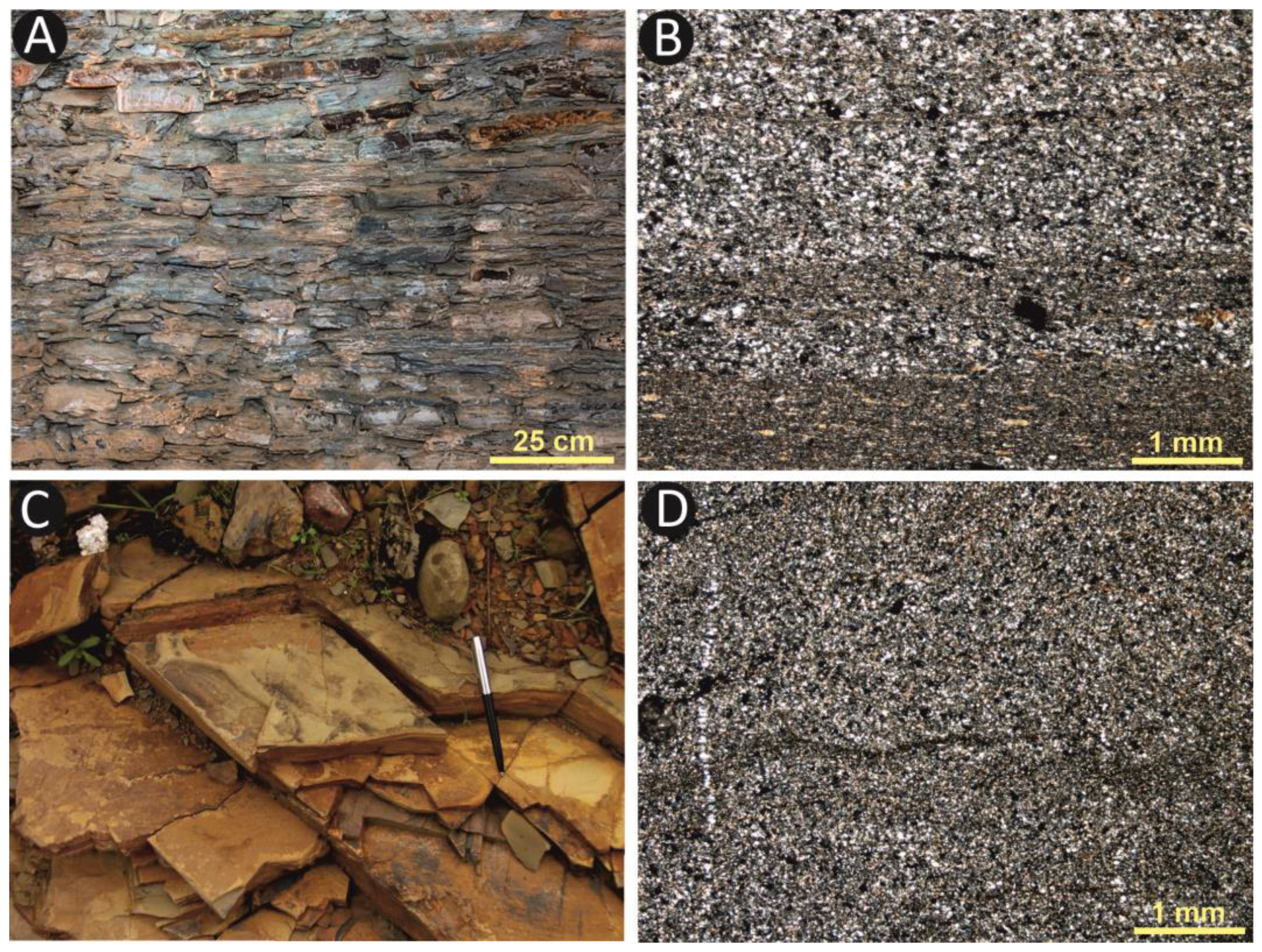
5.1. Petrography of the La Pastora Stones

Quartzarenite is the stone material used in the masonry walls of the tholos (Figure 2). They are natural “bricks”, with commonly rhombohedral shapes and variable sizes but in the decimetric range (Figure 4A). Their faces are natural and correspond to stratification, foliation, and/or jointing surfaces. These rocks have fine intercalations of shales. Both materials show horizontal and cross laminations. Thin sections show a well-sorted, very fine-grained quartzarenite formed by quartz and, to a lesser extent, feldspars, white mica, green mica (chlorite?), and opaque minerals included in a sericitic matrix. The shale intercalations have a mineralogical composition similar to quartzarenite but with a greater abundance of sericite. The alternation of quartzarenite and shale can also be observed in thin sections, as layers of lighter color and coarser grain size (sandstone) and layers of darker color and finer grain size (Figure 4B).
The granite slabs all appear to be fairly homogeneous, except for one of them, which has an aplite dyke on one of its edges (Figure 2, capstone number 8), resulting in an interesting contrast of texture and color.
The structure of these blocks is massive (Figure 5A), and the texture under the microscope is equigranular hypidiomorphic, with a grain size between 1 and 2 mm (Figure 4B). Its essential mineralogical components are quartz, plagioclase, alkali feldspar, and biotite, although the latter in a smaller proportion. Apatite, opaque minerals, and zircon are accessory minerals. Chlorite, which appears because of the alteration of biotite crystals, and sericite, due to the alteration of alkali feldspars, are secondary minerals. An interesting textural characteristic of these granites is a micrographic texture with intergrowths of quartz and alkali feldspar, which gives rise to singular black and white patterns when viewed under the petrographic microscope with cross-polarized transmitted light. (Figure 5B).
As mentioned above, granite capstone number 8 (Figure 2 and Figure 6) partially includes an aplite dyke on one of its edges. Aplite is a subvolcanic rock with a composition similar to granite but with a very fine grain size and a whitish color due to the absence of black micas (biotites).
Calcareous sandstone is the third rock type found in the monument (Figure 7A) and is the one that has been used with greater functionality, as mentioned above (Figure 2). These are rocks of the Neogene age that present numerous sedimentary and biogenic structures original to the deposit (synsedimentary) and prior to the diagenetic processes of consolidation of these deposits. Among the sedimentary structures, there are very evident current marks as well as laminations, mainly horizontal. Regarding the bioturbation structures, the Ophiomorpha ichnogenus, which are vertical and horizontal burrows related to the activity of decapod crustaceans, stand out for their abundance.
On the other hand, some sandstone slabs present bioerosion structures and remains of recent marine organisms, such as ostreids, barnacles, and petrophagous bivalves, the latter (Petricola lithophaga Retzius) inside their boring excavated in the rock itself (Figure 7A) [7,8].
In thin sections, the calcareous sandstone has a very fine grain size (around 0.1 mm) and is generally well sorted (Figure 7B). Mineralogically, it is essentially composed of quartz grains in a percentage of around 60%, with angular to subangular shapes, and abundant fossil remains (foraminifera, bivalves, spicules, and echinoderm plates) in a percentage of around 20%. Minor mineral components include plagioclase, white micas, tourmalines, and opaque minerals. The rest of the rock (20%) is carbonate cement.

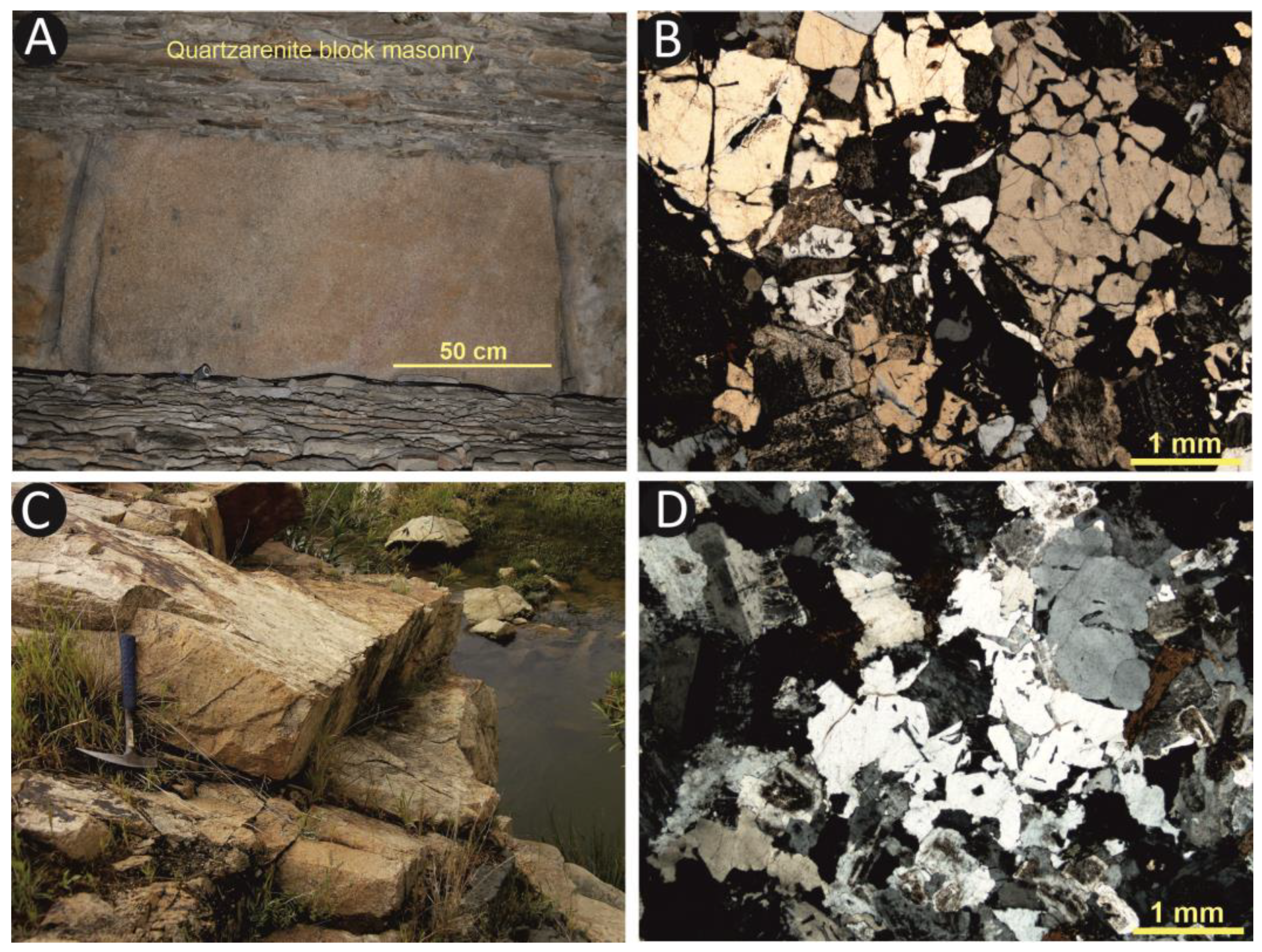
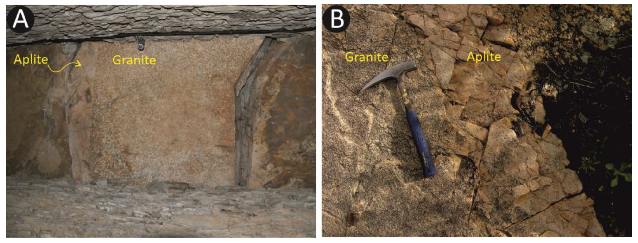
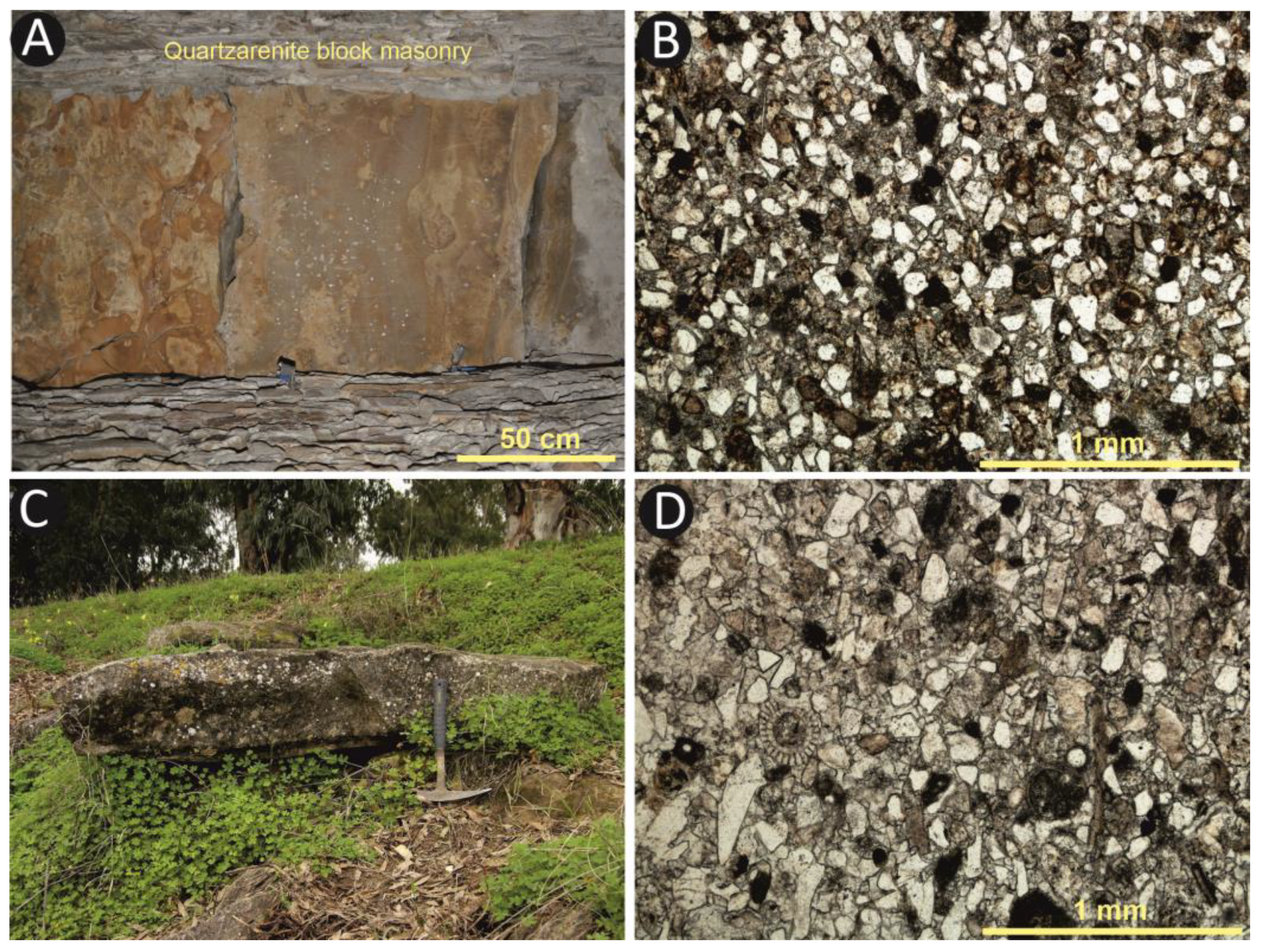
5.2. Petrologic Relationships between the Stones of the Tholos and Nearby Outcrops

La Pastora tholos is located on a substrate of soft sediments, specifically on yellow sandy silts with calcareous nodules from the Lower Pliocene of the Guadalquivir Basin (Figure 3). Therefore, the stone materials used in its construction were quarried from areas not in its immediate surroundings. In order to fulfill the main objective of this study, once the materials of the monument have been characterized and classified, the next step is the analysis of the nearest outcrops of similar rocks, according to the geological framework seen above. In this way, a detailed petrographic comparison of the different lithofacies used for the construction of the tholos with the geological outcrops can then be made.
Quartzarenite, which occurs in the corridor blocks, is described in the region among the PQ group materials [42] (Figure 3). In fact, they are alternations of quartzoarenites and shales, with a predominance of the former. Despite showing fairly homogeneous lithofacies throughout the outcrops, their structures and textures are regionally variable. Thus, the facies closest to the granites show features of contact metamorphism, with the formation of hornfels and spotted slates, which is reflected in the outcrops extending further south and west [43]. On the other hand, facies that have undergone more deformation and show very penetrative tectonic foliations are frequent, making them very weak and fracturable rocks. Neither of the above two characteristics is observed in the La Pastora quartzarenites, so examination somewhat further north is necessary to find outcrops of similar rocks. Thus, in the area known as Cuesta de la Media Fanega (Figure 4C and Figure 8), c. 30 km north of Valencina, this particular type of sandstone appears, very similar to that which makes up the walls of La Pastora tholos. In addition, it can be observed in the outcrop how this rock is affected by double jointing, which adds to the stratification surfaces typical of its sedimentary nature. These natural surfaces form angles between each other and define decimetric blocks very similar to those observed in the masonry of La Pastora’s walls. This situation also facilitates the possible extraction in the outcrops themselves by simple levering between the discontinuities, which means that these already defined blocks can be detached without having to make much effort and without the need for subsequent retouching work. Also, the size of the blocks facilitates their transport, as they are not too heavy or large.
The petrographic features observed in the thin section of the samples from Cuesta de la Media Fanega (Figure 4D) are like those of the quartzarenites found in La Pastora: they are rocks composed essentially of quartz grains of very fine grain size, well sorted, and with accessory contents of feldspars, micas, and opaque minerals included in a sericitic matrix. If both samples are compared, the similarities are evident (Figure 4B,D), as they are basically the same rock with the same characteristics. Therefore, it is highly likely that the quartzarenites from La Pastora came from this area (Figure 8), located 30 km north of the megalith. No extraction points, i.e., possible quarries, have been located, which seems complicated given the rugged and forested characteristics of the area.
The granite outcrops are closest to the La Pastora tholos and, with the same mineralogical and textural features, are found in the batholith of the Sierra Norte de Sevilla, specifically in the vicinity of the towns of Guillena and Gerena (Figure 3), some 15 km to the north of Valencina, where these rocks are still being exploited nowadays in open-air quarries. As can be seen in Figure 5C, these granite formations display a very significant structural feature, namely the existence of intersecting joints that delimit well-defined blocks. The joints parallel to the topography are typical of massive rocks formed at great depths because of decompression processes due to surface erosion, known as sheeting [44]. In addition, tectonic processes can generate other subvertical joints. These geological processes lead to the natural formation of slabs and blocks, which can greatly facilitate the extraction of stones suitable for megalithic construction by means of levers and wedges probably supported by fire and water. However, the size and thickness of these extracted blocks are conditioned by nature, and their use by the Valencina megalith-builder must have been adapted accordingly.
Under the microscope, the Gerena and Guillena granites also have a hypidiomorphic equigranular texture, medium grain size (1–2 mm), and a mineralogical composition identical to those found in the granite capstones of La Pastora (Figure 5D). In addition, these granites also have a micrographic texture (Figure 5B), which is typical of epizonal granites, i.e., those that crystallized in a relatively shallow emplacement.
Aplite dykes are also observed in these granite outcrops (Figure 6B). These dykes are the result of the crystallization of magmas that intruded through fractures in previous rocks, in this case, granites. Thus, they are included in the rock massifs, with clear and planar contact with their host rocks, and outcrop without any physical separation between them. Part of such a dyke is represented in block 8 of La Pastora’s corridor roof (Figure 6A). Apart from aplites, these granite outcrops also have important diabase dykes. These latter materials have been found in Valencina and are commonly used for axes.
Therefore, given the mineralogical and textural similarity, as well as the occurrence of aplite dykes and the characteristics of the observed jointed, we can determine that the sector around the towns of Guillena and Gerena is the most likely place of origin of the granites that appear in La Pastora. Furthermore, these are the closest granite outcrops to Valencina (Figure 8). On the other hand, these outcrops are probably the source of the granite used to manufacture the fragments of grinding slabs commonly found in the pits and ditches of Valencina [45].
The calcareous sandstone of the tholos and its palaeontological content indicate that they are Miocene materials from the Guadalquivir Basin, specifically corresponding to the Transition Facies. These facies outcrop in the vicinity of Valencina (Figure 3) and constitute, from a stratigraphic point of view, the transition between the lower marly formations and the upper sandy silts. It is predominantly a rhythmic alternation of clayey–silty and sandy–sandstony terms, but towards the top of the series there are 10–70-cm-thick levels of carbonated sand and sandstone alternating with 10–30-cm-thick strata of clay [35] (Figure 7C). Therefore, it would be from these carbonate sandstone levels that all the sandstones in La Pastora would come from (Figure 2).
Under the microscope (Figure 7D), the composition of the rocks sampled in the field is mostly subangular quartz grains, like the sandstone of La Pastora (Figure 7B). Also noticeable and comparable is the high content of microfauna and the remains of other organisms, as well as the content of other minerals and carbonate cement and their proportion. The only apparent difference between the two thin sections is the grain size, which is slightly larger in the field sample. However, this small difference in grain size is very common in sedimentary rocks, in which variations can occur between different levels or even lateral facies changes within the same level as the energetic conditions of the environment in which they were deposited change. Therefore, it is the same rock.
As mentioned above, this geological formation outcrops in the vicinity of Valencina. However, it does so at heights of around 100 m and does not show the bioerosion or the remains of recent marine fauna that appear in many slabs at La Pastora. These organisms have been radiocarbon dated to between 5460 and 4300 years B.P. [7], a period when the sea level was at or slightly above the present sea level [3,46]. On the other hand, it has been found that many of the borings excavated by lithophagous bivalves in the capstones of La Pastora are filled with littoral sand with abundant marine microfauna [47]. Therefore, we interpret that these stones were extracted from a coastal environment where this formation was outcropping and where there was intense biological activity in the intertidal zone and below it [7]. The alternation of clayey materials, which are weaker, and sandstones cemented by calcium carbonate, which are more resistant, would mean that coastal erosion would eliminate the weak sediments, and the resistant ones would remain as ledges or detached blocks in the same intertidal zone. Therefore, the location of this outcrop should correspond to a point where the Transition Facies outcrops at present sea level. This situation occurs in the area around the present-day town of Coria del Río, some 15 km south of Valencina, thanks to the slight southward inclination, over 2%, of this geological formation [7]. The geography at this place today is very different from that of the third millennium BC, when, after the Flandrian transgression, the mouth of the Guadalquivir River formed a wide bay and the sea entered many kilometers along its lower valley (Figure 8). At present, this sector is largely covered by sediments of the river, which form its alluvial plain and the marshes at its mouth, so that the exact outcrop where these calcareous sandstones were extracted and then used to build La Pastora would be hidden and buried under these sediments [7]. The sample studied (Figure 5C,D) corresponds to the sandstone outcrops belonging to the Transition Facies in the locality of Coria del Río at the lowest levels where it has been possible to sample and, therefore, the closest in elevation to the possible original quarry.
The map shown in Figure 8 synthesizes the location of the most likely candidate sources for all the stone types identified at La Pastora, as described above. Furthermore, this map is intended as an approximation to the geography of the third millennium BC in the area around Valencina and the mouth of the Guadalquivir. The relationship that can be deduced from this geographical situation and the places of origin of the rocks leads us to think about the possibility of using boats to transport the materials. The quartzarenite blocks are relatively easy to transport due to their size and weight, but the proximity of the Rivera de Huelva River and its close confluence with the Guadalquivir suggest that this river may have been used not only as a means of locating and accessing the outcrops but also as a means of transporting the stones. At least, it is within reason to expect that once the Guadalquivir River was reached, its greater flow and depth would allow the use of larger rafts or boats, which may have been used to transport the stones. It should also be borne in mind that a slightly higher sea level and the proximity in time of the Flandrian maximum would represent a greater availability of water in the lower courses of the rivers, which would make them more navigable.
In the same way, the granite blocks could also have been transported by land to the Rivera de Huelva or to its confluence with the Guadalquivir, and from there by raft or boat to the base of the Aljarafe plateau, where the Valencina mega-site is located.
Regarding the calcareous sandstones, the outcrop itself must have been on the coast of the bay formed at the mouth of the Guadalquivir, as explained above, so it would have been easier to move the rocks out to sea than overland. In this way, the main effort would be to load the stones in the right place and in the right way, to later go up the palaeoestuary to the landing area at the foot of Valencina.
However, although this type of transport seems the most reasonable, there is no evidence to confirm it, and, therefore, we should not rule out the possibility that all this type of lithological material was moved by land, given that all the locations are on the right bank of the Guadalquivir River.
From a social perspective, the catchment and transportation of these stones from the quarries onto the building site would have been supported by a network of these communities, which frequented the Valencina mega-site and were integrated into the very socio-cultural fabric that led to its definition as a central place of supra-regional significance. There is ample evidence of Copper Age occupation throughout the Lower Guadalquivir River, in some cases very near the possible quarrying sites mentioned above—for some examples, see Andalusia and the province of Seville [48,49,50], the area around Cuesta de la Media Fanega [50], Gerena [51], Coria del Río, and the surrounding area [52].

6. Conclusions

The location of the Valencina mega-site is, in addition to the advantages mentioned in the introduction regarding its dominant position in proximity to the Guadalquivir River and diversity of natural resources, the stability of the terrain on which it stands. The Aljarafe plateau is made up of soft sandy sediments from the Guadalquivir basin but is much more stable for construction compared to the expansiveness of the nearby clayey soils somewhat further north. However, among these more immediate geological materials, lithic resources are very scarce, so they had to be procured and brought to the site for a wide array of uses and needs, including megalithic constructions.
Unlike other megaliths in southern Iberia, which were essentially built with materials extracted from nearby areas (Menga, Soto, Alberite, or El Pozuelo), for the construction of the La Pastora tholos, the Valencina builders had to source a greater lithological diversity from areas farther afield. This shows that the lack of nearby lithic resources was not an obstacle to the genesis and subsequent flourishing of the mega-site, particularly between c. 2900 and 2300 BC. The lack of immediate stone quarries was easily solved, firstly, thanks to the social network Valencina was part of across a large territory, and secondly, through a detailed knowledge of the environment. The latter allowed the architects of monuments like La Pastora to choose the right types of rocks for their construction; the former facilitated the acquisition and transportation of these materials from a host of locations to the site. Another important fact is that, compared to the megaliths mentioned above, the lithological diversity of the Valencina monuments suggests a greater concern for decoration, design, and/or differentiation on the part of the builders [8].
In the particular case of La Pastora, three types of rocks from three different locations were used:
Quartzarenite is used in blocks of decimetric size and placed as dry masonry to form the walls of the monument. These rocks come from the geological formation known as PQ, which belongs to the Iberian Pyritic Belt (IPB) of the Iberian Massif and whose outcrops with rocks with characteristics more similar to those of La Pastora are located at a distance of around 30 km to the north of Valencina.
Granite, used in large capstones, covers the chamber and part of the corridor. These are rocks from the Sierra Norte de Sevilla batholith of the Iberian Massif. The nearest outcrops of this lithology, and where these La Pastora materials probably come from, are 15 km north of Valencina.
Calcareous sandstone has been used as floor slabs, lintels, and jambs that delimit the different sectors of the monument, blocks of the upper rows of the masonry of the tholos chamber, and as capstones on the corridor. This rock comes from the Upper Miocene Transition Facies geological formation that outcrops in the area around Valencina. However, the presence of marine bioerosion, remains of marine fauna, and beach sand in bioerosioned borings, all dated to the third millennium BC, has led us to determine that these stones come from coastal outcrops in the area around the present-day town of Coria del Río, some 15 km south of Valencina.
In none of the three cases has it been possible to locate the original quarries from which these stones came, but at least it has been possible to determine the minimum distances these materials had to travel to the location of the tholos. It also points to the means of extraction of each one of them, largely facilitated by the existence of discontinuities such as fractures, joints, or stratification surfaces or by the work exerted by coastal agents such as waves in the case of the calcareous sandstones. However, the greatest effort for the builders must have been the transfer of the materials from their outcrops to the monument. In this sense, given the situation of the source areas and the regional geography in the third millennium BC, it is suggested that the easiest form of transport could have been by boat both from the north, along the Rivera de Huelva and the Guadalquivir, and from the south, bordering the palaeocoast of the post-Flandrian marine inlet and ascending the final stretch of the Guadalquivir, to the foot of the Valencina mega-site.

Author Contributions

Conceptualization: L.M.C. and T.D.; methodology: all authors; software, T.D. and S.R.-C.; validation: J.M.V., J.R.-V., L.G.S. and F.M.; formal analysis: T.D.; investigation: all authors.; resources: L.M.C. and T.D.; data curation: M.M. and F.R.; writing—original draft preparation: L.M.C. and T.D.; writing—review and editing: J.M.V. and L.G.S.; visualization: all authors; supervision: L.M.C. and T.D.; project administration: L.M.C.; funding acquisition: L.M.C. All authors have read and agreed to the published version of the manuscript.

Funding

This research was funded by EPIT-2020 of the University of Huelva (Proyectos IP Noveles 636). Other funds have come from the Andalusian Government (group RNM-293). It is a contribution to the Research Center in Historical, Cultural, and Natural Heritage (CIPHCN) of the University of Huelva.

Data Availability Statement

The data is available within the article.

Conflicts of Interest

The authors declare no conflicts of interest.

References

  1. Barragán Mallofret, D. La línea de costa flandriense en el Paleoestuario del Río Guadalquivir (c. 6500 BP). Rev. Atl-Med. Prehist. Arqueol. Soc. 2016, 18, 111–138. [Google Scholar] [CrossRef]
  2. Borja Barrera, F.; Borja Barrera, C.; Jiménez Sancho, Á.; García Vargas, E. Evolución de la llanura aluvial del bajo Guadalquivir durante el Holoceno medio-superior. Geoarqueología y reconstrucción paleogeográfica de la vega de Itálica (Santiponce, Sevilla, España). Bol. Geol. Min. 2018, 1129, 371–420. [Google Scholar] [CrossRef]
  3. Zazo, C.; Goy, J.L.; Somoza, L.; Dabrio, C.J.; Belluomini, G.; Improta, S.; Lario, J.; Bardají, T.; Silva, P.G. Holocene sequence of relative sea level highstand lowstand in relation to the climatic trends in the Atlantic–Mediterranean linkage coast: Forecast for future coastal changes and hazards. J. Coast. Res. 1994, 10, 933–945. [Google Scholar]
  4. Vargas, J.M. Elementos para la definición territorial del yacimiento prehistórico de Valencina de la Concepción (Sevilla). Spal 2003, 12, 125–144. [Google Scholar] [CrossRef]
  5. García-Sanjuán, L.; Scarre, C.; Wheatley, D. The mega-site of Valencina de la Concepción (Seville, Spain): Debating settlement form, monumentality and aggregation in southern Iberian Copper Age Societies. J. World Prehist. 2017, 30, 239–257. [Google Scholar] [CrossRef]
  6. Nocete, F.; Queipo, G.; Saez, R.; Nieto, J.M.; Inácio, N.; Bayona, M.R.; Peramo, A.; Vargas, J.M.; Cruz-Auñón, R.; Gil-Ibarguchi, J.I.; et al. The smelting quarter of Valencina de la Concepción (Seville, Spain): The specialised copper industry in a political centre of Guadalquivir Valley during the Third millennium BC (2750–2500 BC). J. Archaeol. Sci. 2008, 35, 717–732. [Google Scholar] [CrossRef]
  7. Cáceres, L.M.; Muñiz, F.; Rodríguez-Vidal, J.; Vargas, J.M.; Donaire, T. Marine bioerosion in Rocks of the prehistoric tholos of La Pastora (Valencina de la Concepción, Seville, Spain): Archaeological and palaeoenvironmental implications. J. Archaeol. Sci. 2014, 41, 435–446. [Google Scholar] [CrossRef]
  8. Cáceres Puro, L.M.; Vargas, J.M.; Muñiz, F.; Donaire, T.; García Sanjuán, L.; Odriozola, C.; Rodríguez-Vidal, J. Natural “Megalithic art” at Valencina (Seville): A Geoarchaeological Approach to Stone, Architecture, and Cultural Choice in Copper Age Iberia. Archaeol. Anthropol. Sci. 2019, 11, 4621–4641. [Google Scholar] [CrossRef]
  9. Fernández, A.; Aycart, V. Montelirio. Un sepulcro clave para la comprensión del registro de los grandes monumentos megalíticos de Valencina de la Concepción-Castilleja de Guzmán (Sevilla). In El Asentamiento Prehistórico de Valencina de la Concepción (Sevilla): Investigación y Tutela en el 150 aniversario del Descubrimiento de La Pastora; García Sanjuán, L., Vargas, J.M., Hurtado, V., Ruiz Moreno, T., Cruz-Auñón, R., Eds.; Universidad de Sevilla: Sevilla, Spain, 2013; pp. 233–259. [Google Scholar]
  10. Mora Molina, C.; García SanJuán, L.; Peinado Cucarella, J.; Wheatley, D.W. Las estructuras de la edad del cobre del sector PP4-Montelirio del sitio arqueológico de Valencina de la Concepción-Castilleja de Guzmán (Sevilla). In El Asentamiento Prehistórico de Valencina de la Concepción (Sevilla): Investigación y Tutela en el 150 aniversario del Descubrimiento de La Pastora; García Sanjuán, L., Vargas, J.M., Hurtado, V., Ruiz Moreno, T., Cruz-Auñón, R., Eds.; Universidad de Sevilla: Sevilla, Spain, 2013; pp. 261–279. [Google Scholar]
  11. Lozano Rodríguez, J.A.; García Sanjuán, L.; Álvarez-Valero, A.M.; Jiménez-Espejo, F.; Arrieta, J.M.; Fraile-Nuez, E.; Montero Artús, R.; Cultrone, G.; Muñoz-Carballeda, F.A.; Martínez-Sevilla, F. The provenance of the stones in the Menga dolmen reveals one of the greatest engineering feats of the Neolithic. Sci. Rep. 2023, 13, 21184. [Google Scholar] [CrossRef]
  12. Parker Pearson, M.; Pollard, J.; Richards, C.; Welham, K.; Casswell, C.; French, C.; Schlee, D.; Shaw, D.; Simmons, E.; Standford, A.; et al. Megalith quarries for Stonehenge’s bluestones. Antiquity 2019, 93, 45–62. [Google Scholar] [CrossRef]
  13. Parker Pearson, M.; Bevis, R.; Ixer, R.; Pollard, J.; Richards, C.; Welham, K. Long-distance landscapes: From quarries to monument at Stonehenge. In Megaliths and Geology: Megálitos e Geologia: MEGA-TALKS 2: 19–20 November 2015 (Redondo, Portugal); Boaventura, R., Mataloto, R., Pereira, A., Eds.; Archaeopress Access Archaeology: Oxford, UK, 2020; pp. 151–170. [Google Scholar] [CrossRef]
  14. Lipo, C.; Hunt, T.L. Mapping prehistoric statue roads on Easter Island. Antiquity 2005, 79, 158–168. [Google Scholar] [CrossRef]
  15. Martínez-Torres, L.M.; Fernández-Eraso, J.; Mujika-Alustiza, J.A.; Rodríguez-Miranda, Á.; Valle-Melón, J.M. Geoarchaeology and Construction of the La Chabola de la Hechicera Megalithic Tomb, Elvillar Northern Spain. Geoarchaeology 2014, 29, 300–311. [Google Scholar] [CrossRef]
  16. Martínez-Torres, L.M. Building Materials of Neolithic Tombs in Alava Northern Spain. Open Constr. Build. Technol. J. 2017, 11, 152–163. [Google Scholar] [CrossRef]
  17. Vegas, J.I.; Martínez-Torres, L.M.; Orue-Etxebarria, X.; García-Garmilla, F.J. Procedencia de las rocas empleadas en el dolmen de Aizkomendi (Eguílaz, Álava). In The Late Quaternary in the Western Pyrenean Region; Cearreta Bilbao, A., Ugarte, F.M., Eds.; Universidad del País Vasco: Bilbao, Spain, 1992; pp. 427–433. [Google Scholar]
  18. Vicens, E.; Arribas, E.; Clop, X.; Estrada, R.; Maestro, E.; Oms, O.; Serrat, D.; Molist, M. Characterization and provenance of the slabs of the Puigseslloses Megalith, Barcelona Spain. Geoarchaeology 2010, 25, 195–219. [Google Scholar] [CrossRef]
  19. Kalb, P. Rare rocks in the megalithic monuments of Vale de Rodrigo, Portugal. Menga J. Andalusian Prehist. 2011, Monográfico 1, 371–381. [Google Scholar]
  20. Moleiro, V.; Cura, S.; Sá, A.; Oosterbeek, L. Petrological identification of the slabs used at the Anta da Lajinha. In Megalithic Tombs in Western Iberia. Excavations at the Anta da Lajinha; Scarre, C., Oosterbeek, L., Eds.; Oxbow Books: Oxford, UK, 2019; pp. 62–67. [Google Scholar]
  21. Boaventura, R.; Moita, P.; Pedro, J.; Mataloto, R.; Almeida, L.; Nogueira, P.; Máximo, J.; Pereira, A.; Santos, J.F.; Ribeiro, S. Moving megaliths in the Neolithic—A multi analytical case study of dolmens in Freixo-Redondo (Alentejo, Portugal). In Megaliths and Geology: Megálitos e Geologia: MEGA-TALKS 2: 19–20 November 2015 (Redondo, Portugal); Boaventura, R., Mataloto, R., Pereira, A., Eds.; Archaeopress Access Archaeology: Oxford, UK, 2020; pp. 1–24. [Google Scholar] [CrossRef]
  22. Bueno Ramírez, P.; Barroso Bermejo, R.; de Balbín Behrmann, R.; González Marín, A.; Cambra-Moo, O.; García Gil, O.; Odriozola-Lloret, C.; López, O.; Escalante, S.; Lancharro-Guitiérrez, M.A.; et al. Pasados releídos: El dolmen del Portillo de las Cortes, Guadalajara/MAN. Bol. Mus. Arqueol. Nac. 2016, 34, 9–28. [Google Scholar]
  23. Doyague, A. Materias primas constructivas en el dolmen de Alberite II. Análisis petrológico, áreas fuente geológicas: Aportaciones arqueológicas a la definición de un megalito destruido en la necrópolis de Villamartín. Rev. Atl-Med. Prehist. Arqueol. Soc. 2015, 17, 67–79. [Google Scholar] [CrossRef]
  24. García Sanjuán, L.G.; Afonso Marrero, J.A.; Bueno Ramírez, P.; de Balbín Behrmann, R.; Lozano Rodríguez, J.A.; Martínez Fernández, G.; Wheatley, D.W.; Cintas Peñas, M. Striking, colourful, smooth, rare: Lithic resouces and cultural choices in the architecture, sculpture and portable artefacts of the Palacio III tholos monument (Seville, Spain). Trab. Prehist. 2019, 76, 254–271. [Google Scholar] [CrossRef]
  25. Aranda Jiménez, G.; Lozano, J.A.; Pérez Valera, F. The megalithic necropolis of Panoria, Granada, Spain: Geoarchaeological characterization and provenance studies. Geoarchaeology 2018, 33, 260–270. [Google Scholar] [CrossRef]
  26. Linares-Catela, J.A.; Donaire Romero, T.; Mora Molina, C.; Cáceres Puro, L.M. Choosing the site, getting the stones, building the dolmens: Local sourcing of andesites at the El Pozuelo megalithic complex (Huelva, Spain). Archaeol. Anthropol. Sci. 2023, 15, 101. [Google Scholar] [CrossRef]
  27. Borja Barrera, F.; Borja Barrera, C. Los materiales constructivos pétreos de Montelirio. In Montelirio: Un Gran Monumento Megalítico de la Edad del Cobre; Fernández, A., García-Sanjuán, L., Díaz-Zorita, M., Eds.; Junta de Andalucía: Sevilla, Spain, 2016; pp. 143–163. [Google Scholar]
  28. Polo Díaz, A. Geoarqueología y reconstrucción de contextos arqueológicos. Contribución y nuevas perspectivas desde el Área de Prehistoria de la Universidad del País Vasco. Veleia 2007, 24–25, 689–702. [Google Scholar]
  29. Tubino, F.M. Estudios Prehistóricos; Revista de Bellas Artes: Madrid, Spain, 1868; pp. 49–59. [Google Scholar]
  30. Vargas Jiménez, J.M.; Cáceres Puro, L.M.; Odriozola, C. El tholos de La Pastora, una nueva perspectiva a partir del análisis arqueológico de su construcción. Spal 2019, 2, 113–141. [Google Scholar] [CrossRef]
  31. Hoskin, M. Studies in Iberian archaeoastronomy: (9) an overview. Archaeoastronomy 2002, 27, 75–82. [Google Scholar] [CrossRef]
  32. Civis, J.; Dabrio, C.J.; González-Delgado, J.A.; Goy, J.L.; Ledesma, S.; País, J.; Sierro, F.J.; Zazo, C. Cuenca del Guadalquivir. In Geología de España; Vera, J.A., Ed.; IGME: Zaragoza, Spain, 2004; pp. 543–550. [Google Scholar]
  33. Pérez-Valera, F.; Sánchez-Gómez, M.; Pérez-López, A.; Pérez-Valera, L.A. An evaporite-bearing accretionary complex in the northern front of the Betic-Rif orogen. Tectonics 2017, 36, 1006–1036. [Google Scholar] [CrossRef]
  34. Civis, J.; Sierro, F.J.; González Delgado, J.A.; Flores, J.A.; Andrés, I.; Porta, J.; Valle, M. El Neógeno marino de la provincia de Huelva: Antecedentes, y definición de las unidades litoestratigráficas. In Paleontología del Neógeno de Huelva; Civis, J., Ed.; Ediciones de la Universidad de Salamanca: Salamanca, Spain, 1987; pp. 9–21. [Google Scholar]
  35. Mayoral, E.; González, I. Contribución al estudio de las facies de tránsito (Mioceno-Plioceno) en el sector noroccidental de la Cuenca del Guadalquivir (Valencina de la Concepción, Sevilla). Acta Geol. Hispán. 1987, 21–22, 177–184. [Google Scholar]
  36. Schermerhorn, L.J.G. An outline stratigraphy of the Iberian Pyrite Belt. Bol. Geol. Min. 1971, 82, 23–52. [Google Scholar]
  37. Leistel, J.M.; Marcoux, E.; Thiéblemont, E.; Quesada, C.; Sánchez, A.; Almodóvar, G.R.; Pascual, E.; Saez, R. The volcanic-hosted massive sulphide deposits of the Iberian Pyrite Belt. Miner. Depos. 1998, 33, 2–30. [Google Scholar] [CrossRef]
  38. De la Rosa, J.D. Petrologia de las Rocas Básicas y Granitoides del Batolito de la Sierra Norte de Sevilla, Zona Surportuguesa, Macizo Ibérico. Ph.D. Thesis, Universidad de Sevilla, Seville, Spain, 1992. [Google Scholar]
  39. Ehlers, E. Optical Mineralogy, Vols. 1 y 2; Blackwell Scientific: Oxford, UK, 1987. [Google Scholar]
  40. Nesse, W.D. Introduction to Mineralogy; Oxford University Press: Oxford, UK, 2000. [Google Scholar]
  41. Mackenzie, W.S.; Donaldson, C.H.; Guilford, C. Atlas de Rocas Ígneas y Sus Texturas; Ed. Masson S.A.: Barcelona, Spain, 1996. [Google Scholar]
  42. Matas, J.; Martín Parra, L.M.; Rubio Pascual, F.J.; Roldán, F.J.; Martín-Serrano, A. Mapa geológico de España y Memoria, Hoja 74/75 (Sevilla-Puebla de Guzmán). Mapa Geológico de España E 1:200.000; IGME: Madrid, Spain, 2015. [Google Scholar]
  43. Muelas Peña, A.; Crespo Zamorano, A. Mapa geológico de España y Memoria, Hoja 962 (Alcalá del Río). Mapa Geológico de España E 1:50.000; IGME: Madrid, Spain, 1976. [Google Scholar]
  44. Twidale, C.R.; Vidal Romaní, J.R. Landforms and Geology of Granite Terrains; Balkema: Leiden, The Netherlands, 2005. [Google Scholar]
  45. Martínez-Sevilla, F.; García Sanjuán, L.; Lozano Rodríguez, J.A.; Martínez Jordán, J.M.; Scarre, C.; Vargas Jiménez, J.M.; Pajuelo Pando, A.; López Aldana, P. A new perspective on Copper Age technology, economy and settlement. Grinding tools at the Valencina Mega-Site. J. World Prehist. 2020, 33, 513–559. [Google Scholar] [CrossRef]
  46. Goy, J.L.; Zazo, C.; Dabrio, C.J. A beach-ridge progradation complex reflecting periodical sea-level and climate variability during the Holocene (Gulf of Almería, Western Mediterranean). Geomorphology 2003, 50, 251–268. [Google Scholar] [CrossRef]
  47. Ramírez-Cruzado, S.; Muñiz Guinea, F.; Ruiz Muñoz, F.; González-Regalado, M.L.; Vargas Jiménez, J.M.; Díaz-Guardamino, M.; García Sanjuán, L.; Donaire Romero, T.; Rodríguez-Vidal, J.; Cáceres Puro, L.M. Gastrochaenolites as palaeoenvironmental information traps: The case of the Tholos of La Pastora (Valencina de la Concepción, SW Spain). Environ. Archaeol. 2023. [Google Scholar] [CrossRef]
  48. Cruz-Auñón Briones, R.; Moreno Alonso, E.; Cáceres Misa, P. Registros de la expresión poblacional durante el III milenio en Andalucía Occidental. Spal 1992, 1, 125–149. [Google Scholar] [CrossRef]
  49. Lazarich González, M. Bell Beaker settlements in Andalusia. In Bell Beaker Settlement of Europe. In The Bell Beaker Phenomenon from a Domestic Perspective; Gibson, A.M., Ed.; Oxbow: Oxford, UK, 2019; pp. 67–80. [Google Scholar]
  50. IAPH. Megalitos de la Provincia de Sevilla. PH Ediciones Multimedia 3; Junta de Andalucía: Sevilla, Spain, 2000. [Google Scholar]
  51. Guisado, F.; Garrido, P.; Costa, M.E. Catálogos de Bienes Protegidos del PGOU de Gerena, Tomo III; Unpublished Work; Ayuntamiento de Gerena—Diputación de Sevilla: Seville, Spain, 2010. [Google Scholar]
  52. García Rivero, D.; Escacena, J.L. Del Calcolítico al Bronce Antiguo en el Guadalquivir inferior. El Cerro de San Juan (Coria del Río, Sevilla) y el ‘modelo de reemplazo’. Zephyrus 2015, 76, 15–38. [Google Scholar] [CrossRef]
Figure 1. (A): Location and extent (brown) of the Valencina mega-site and position of its main megalithic monuments: 1: La Pastora; 2: Matarrubilla; 3: Montelirio; 4: Structure 10.042–10.049; 5: Ontiveros (background image by Google Earth). (B,C): Views of the interior of La Pastora tholos: from the access towards the interior (B) and from the chamber towards the corridor (C).
Minerals 14 00194 g001
Figure 2. La Pastora section, capstones, and floor plans, with the lithology of their constructive elements and numbering of capstones and floor slabs of the monument ordered from the entrance to the chamber. (modified from [8]).
Minerals 14 00194 g002
Figure 3. Geological setting of the southwest of the Iberian Peninsula, around the Valencina mega-site. Key: 1: Devonian quartzarenites and shales, the PQ Group; 2: Carboniferous Volcanic Sedimentary Complex; 3: Granitoid (SNSB); 4: Basic plutonic rocks (SNSB); 5: Carboniferous greywackes andshales, the Culm Group; 6: Permian volcanic and sedimentary rock (PVB); 7: Triassic clay and gypsum; 8: Miocene marl, sandstone, and flint stone; 9: Tortonian sandstone and conglomerate; 10: Miocene marl, Blue Marl Unit; 11: Transition Facies; 12: Pliocene sand and silt; 13: Quaternary sand (dunes and beaches); 14: Quaternary fluvial deposits (conglomerate, sand, and clay); and 15: marshland. In color, the geological formations from which the stones of La Pastora tholos come (modified from [7]).
Minerals 14 00194 g003
Figure 4. Quartzarenite. (A): Blocks of this lithology as masonry in the walls of La Pastora. (B): A representative thin-section photomicrograph of a block from the monument. (C): Outcrop of the PQ formation in the Cuesta de la Media Fanega area. (D): A thin section of quartzarenites in the latter outcrop.
Minerals 14 00194 g004
Figure 5. Granite. (A): Capstone of granite in La Pastora (view from below). (B): A representative thin-section photomicrograph of this stone. (C): Outcrop of the granite near Guillena. (D): A thin section of granite in the latter outcrop.
Minerals 14 00194 g005
Figure 6. (A): Capstone 8 of La Pastora. It is a granite block with an aplite dyke on the right and is of a lighter color. (B): Same situation in the field outcrop in the Guillena area.
Minerals 14 00194 g006
Figure 7. Calcareous sandstone. (A): Capstone of the sandstone in La Pastora (view from below). (B): A representative thin-section photomicrograph of this lithology from the monument. (C): Outcrop of calcareous sandstone of transition facies in Coria del Río. (D): A thin section of this rock is in the latter outcrop.
Minerals 14 00194 g007
Figure 8. Map showing the approximate situation of the area around Valencina in the third millennium BC. Location of the possible areas of provenance of the rocks of La Pastora with distances to the Valencina mega-site: 1: Cuesta de la Media Fanega. 2: Gerena (west point) and Guillena (east point). 3: Coria del Río. (map art by Francisco Sánchez Díaz).
Minerals 14 00194 g008
Disclaimer/Publisher’s Note: The statements, opinions and data contained in all publications are solely those of the individual author(s) and contributor(s) and not of MDPI and/or the editor(s). MDPI and/or the editor(s) disclaim responsibility for any injury to people or property resulting from any ideas, methods, instructions or products referred to in the content.

